Annular solar eclipse of 01/30/-0299
| Day of week: | Friday |
| Maximum duration of eclipse: | 08m15s |
| Maximum width of eclipse path: | 295 km |
| Saros cycle: | 55 |
| Coverage: | 92.5% |
| Magnitude: | 0.9254 |
| Gamma: | -0.3069 |
Wo kann man die Sonnenfinsternis vom 01/30/-0299 sehen?
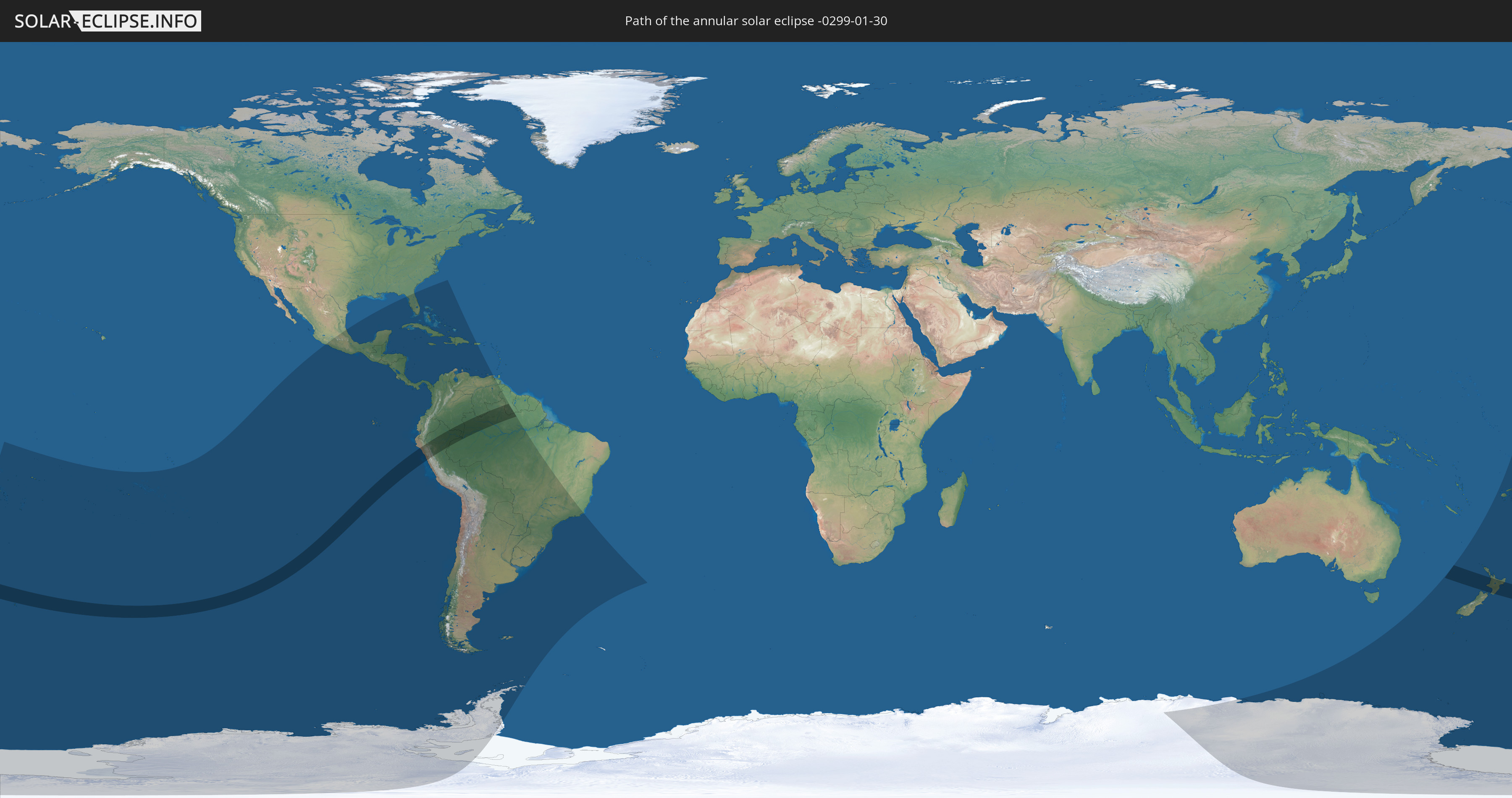
Die Sonnenfinsternis am 01/30/-0299 kann man in 46 Ländern als partielle Sonnenfinsternis beobachten.
Der Finsternispfad verläuft durch 6 Länder. Nur in diesen Ländern ist sie als annular Sonnenfinsternis zu sehen.
In den folgenden Ländern ist die Sonnenfinsternis annular zu sehen
 New Zealand
 Colombia
 Peru
Peru
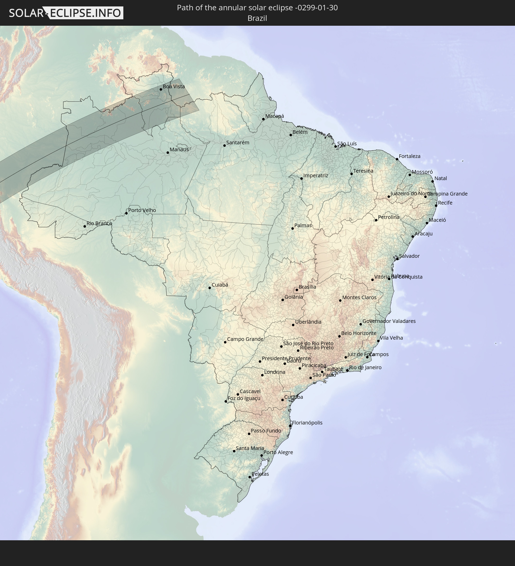 Brazil
 Venezuela
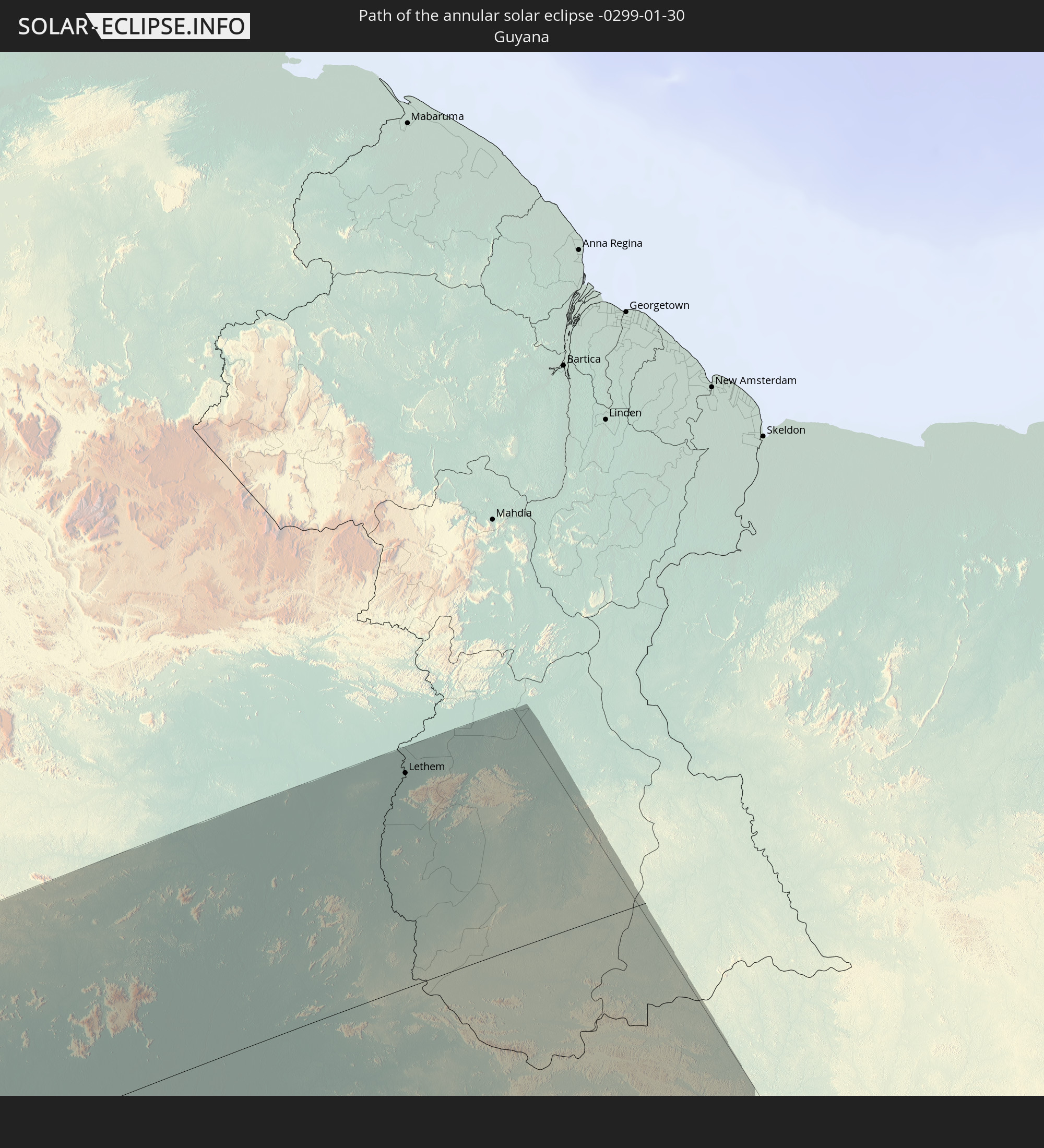 Guyana
In den folgenden Ländern ist die Sonnenfinsternis partiell zu sehen
 Antarctica
 Fiji
Fiji
 United States
 New Zealand
 United States Minor Outlying Islands
 Wallis and Futuna
 Tonga
Tonga
 Kiribati
 Samoa
Samoa
 Tokelau
 American Samoa
 Niue
Niue
 Cook Islands
 French Polynesia
 Pitcairn Islands
 Mexico
 Chile
Chile
 Guatemala
 Ecuador
 El Salvador
 Honduras
 Belize
 Nicaragua
 Costa Rica
 Cuba
Cuba
 Panama
 Colombia
 Cayman Islands
 Peru
Peru
 The Bahamas
 Jamaica
 Haiti
Haiti
 Brazil
 Argentina
 Venezuela
 Turks and Caicos Islands
 Dominican Republic
 Aruba
Aruba
 Bolivia
 Puerto Rico
 Paraguay
 Falkland Islands
 Guyana
 Uruguay
 Australia
 Tuvalu
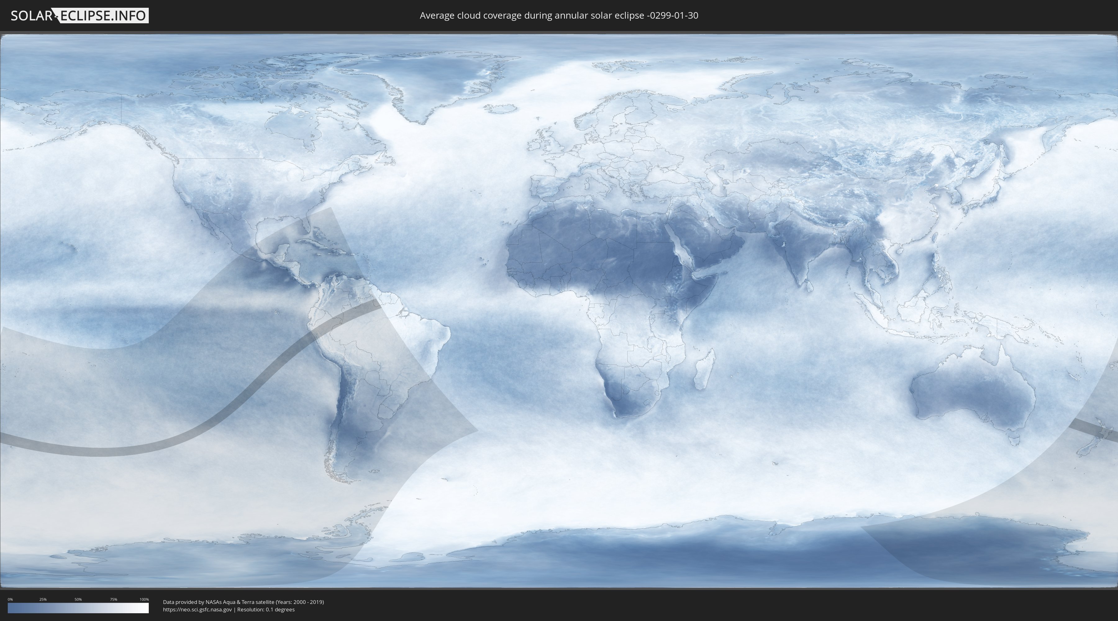
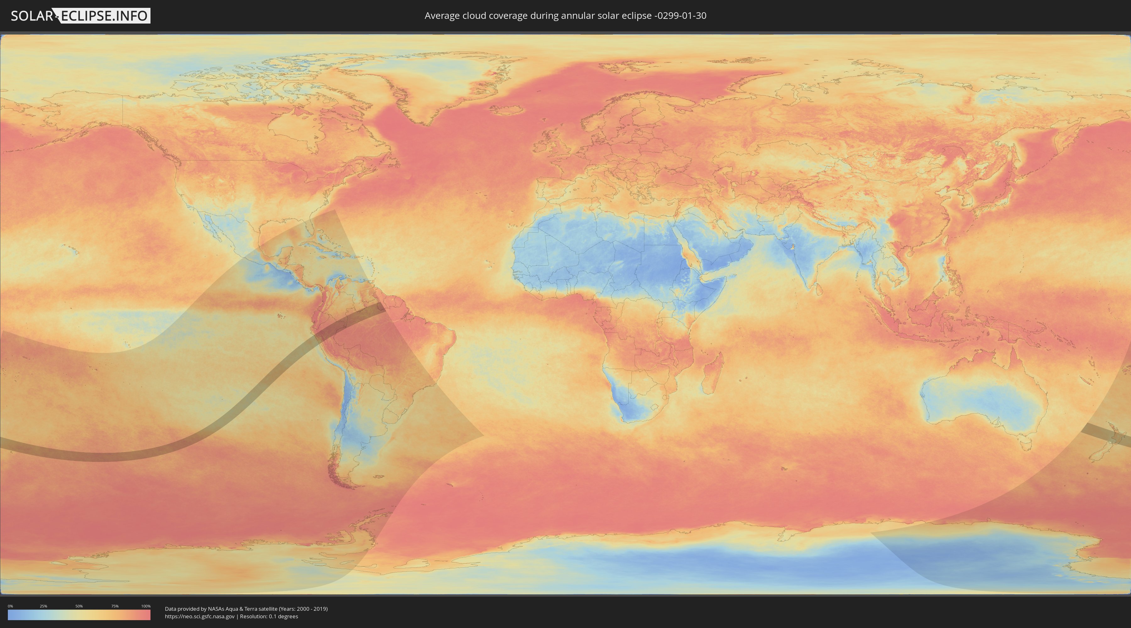
How will be the weather during the annular solar eclipse on 01/30/-0299?
Where is the best place to see the annular solar eclipse of 01/30/-0299?
The following maps show the average cloud coverage for the day of the annular solar eclipse.
With the help of these maps, it is possible to find the place along the eclipse path, which has the best
chance of a cloudless sky.
Nevertheless, you should consider local circumstances and inform about the weather of your chosen
observation site.
The data is provided by NASAs satellites
AQUA and TERRA.
The cloud maps are averaged over a period of 19 years (2000 - 2019).
Detailed country maps
 New Zealand
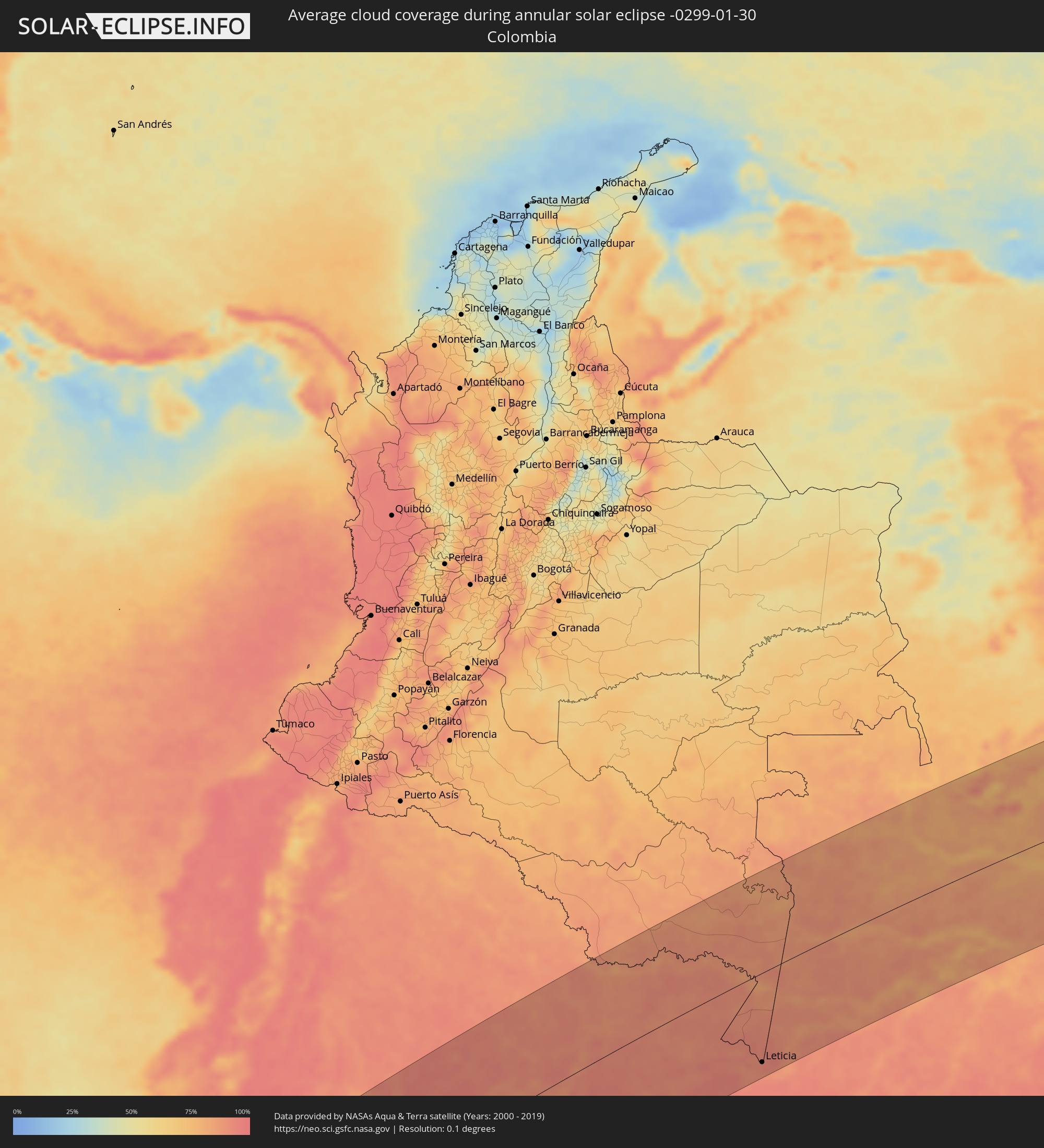 Colombia
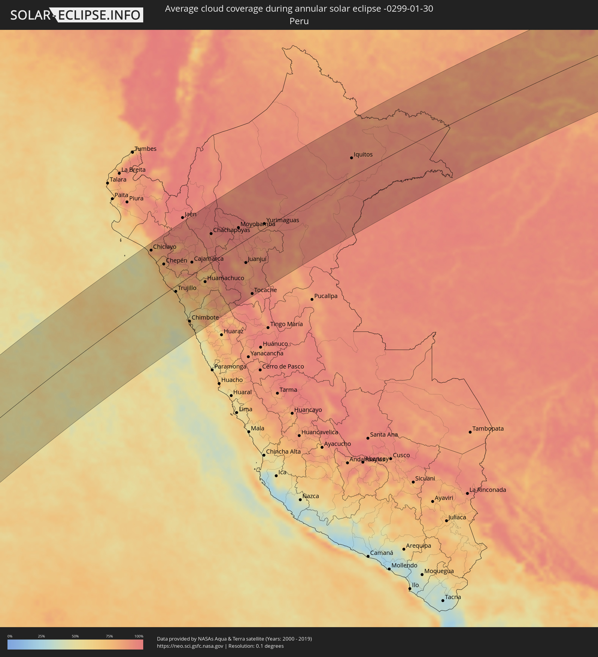 Peru
Peru
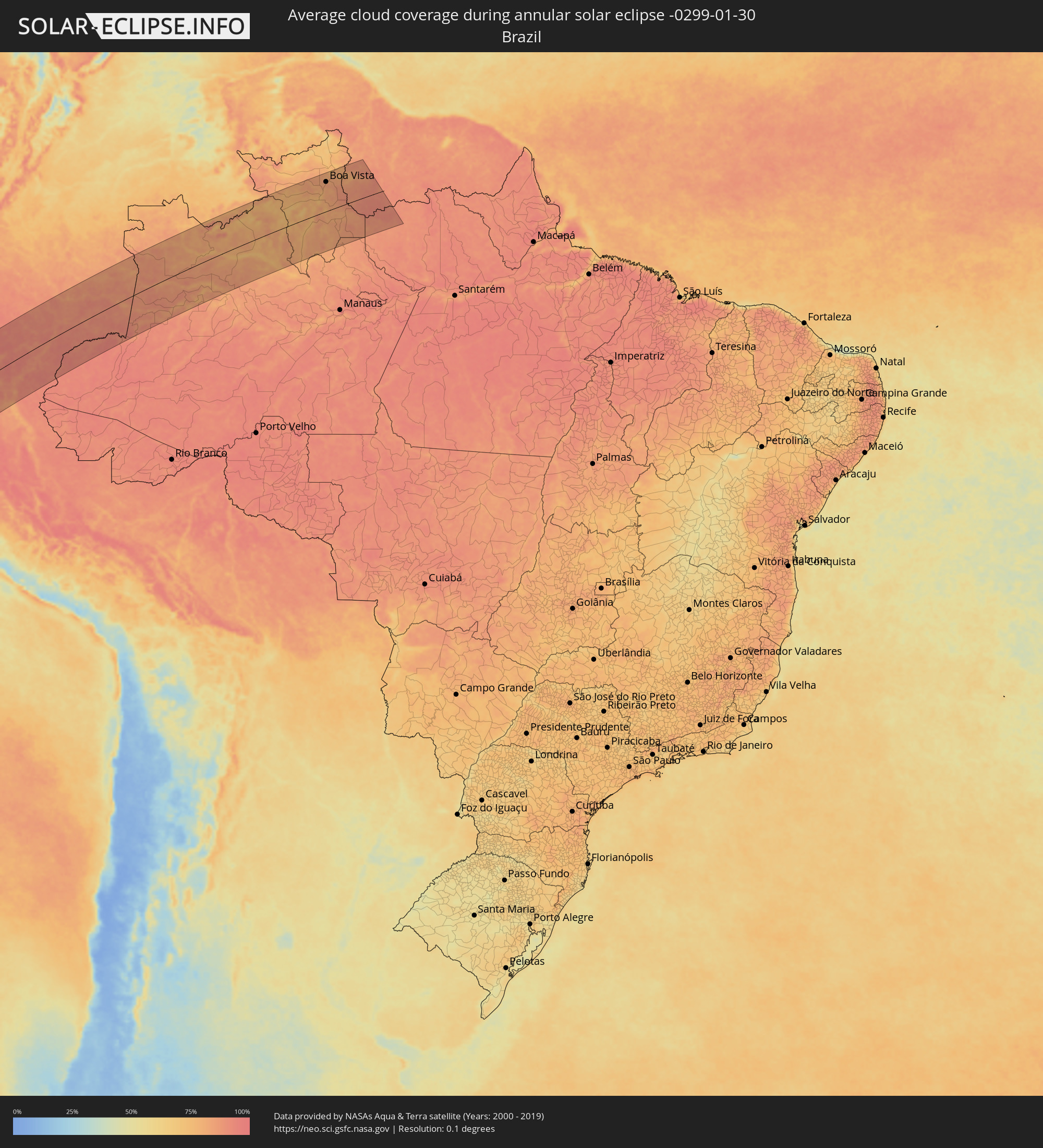 Brazil
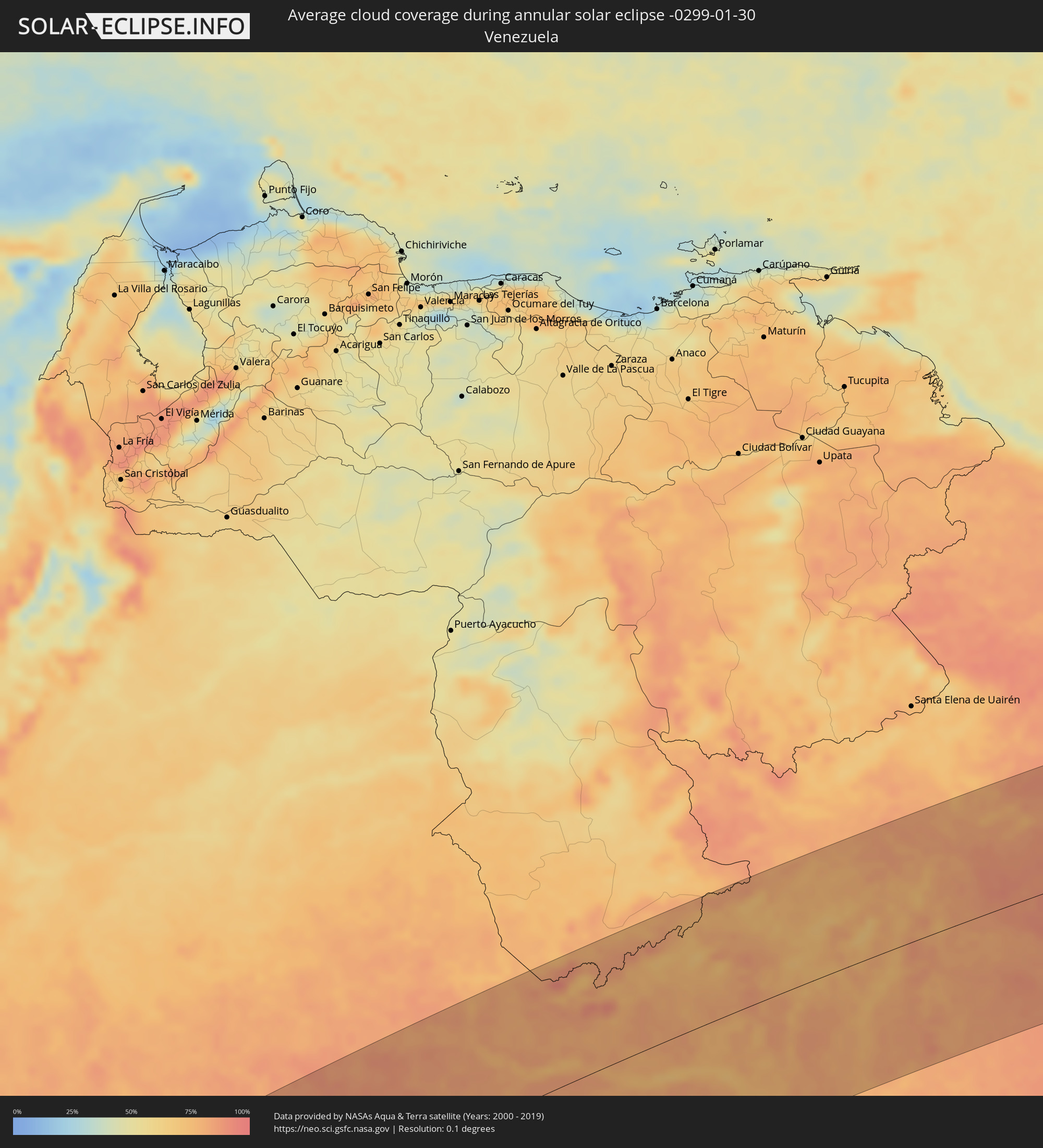 Venezuela
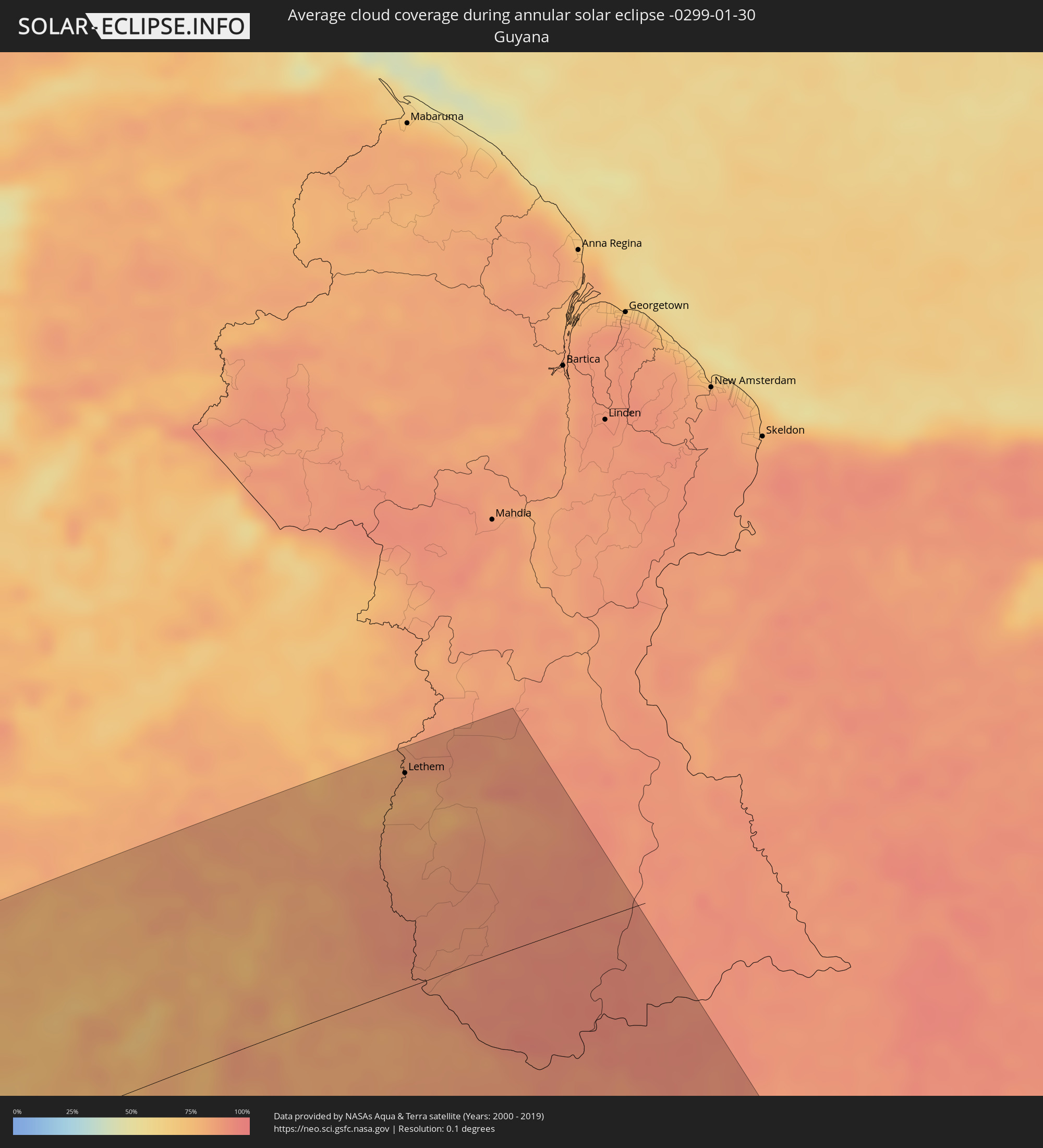 Guyana
Cities inside the path of the eclipse
The following table shows all locations with a population of more than 5,000 inside the eclipse path. Cities which have more than 100,000 inhabitants are marked bold. A click at the locations opens a detailed map.
| City | Type | Eclipse duration | Local time of max. eclipse | Distance to central line | Ø Cloud coverage |
|
Pimentel, Lambayeque
|
annular | - | 16:45:52 UTC-05:08 | 157 km | 76% |
|
Eten, Lambayeque
|
annular | - | 16:45:47 UTC-05:08 | 146 km | 64% |
|
Chiclayo, Lambayeque
|
annular | - | 16:46:00 UTC-05:08 | 157 km | 73% |
|
Santa Rosa, Lambayeque
|
annular | - | 16:46:01 UTC-05:08 | 157 km | 73% |
|
Ferreñafe, Lambayeque
|
annular | - | 16:46:13 UTC-05:08 | 166 km | 81% |
|
Saña, Lambayeque
|
annular | - | 16:45:53 UTC-05:08 | 127 km | 76% |
|
Pacasmayo, La Libertad
|
annular | - | 16:45:10 UTC-05:08 | 82 km | 67% |
|
San Pedro de Lloc, La Libertad
|
annular | - | 16:45:09 UTC-05:08 | 75 km | 71% |
|
Chepén, La Libertad
|
annular | - | 16:45:30 UTC-05:08 | 89 km | 80% |
|
Chongoyape, Lambayeque
|
annular | - | 16:46:23 UTC-05:08 | 141 km | 87% |
|
Santiago de Cao, La Libertad
|
annular | - | 16:44:27 UTC-05:08 | 10 km | 67% |
|
Chocope, La Libertad
|
annular | - | 16:44:43 UTC-05:08 | 25 km | 79% |
|
Chicama, La Libertad
|
annular | - | 16:44:40 UTC-05:08 | 15 km | 67% |
|
Ascope, La Libertad
|
annular | - | 16:44:53 UTC-05:08 | 25 km | 73% |
|
Trujillo, La Libertad
|
annular | - | 16:44:18 UTC-05:08 | 17 km | 73% |
|
Virú, La Libertad
|
annular | - | 16:43:58 UTC-05:08 | 62 km | 67% |
|
Chota, Cajamarca
|
annular | - | 16:46:49 UTC-05:08 | 104 km | 92% |
|
Puerto Santa, Ancash
|
annular | - | 16:43:07 UTC-05:08 | 121 km | 66% |
|
Coishco, Ancash
|
annular | - | 16:43:05 UTC-05:08 | 126 km | 66% |
|
Chimbote, Ancash
|
annular | - | 16:43:00 UTC-05:08 | 134 km | 66% |
|
Bambamarca, Cajamarca
|
annular | - | 16:46:39 UTC-05:08 | 85 km | 88% |
|
Cajamarca, Cajamarca
|
annular | - | 16:45:58 UTC-05:08 | 38 km | 82% |
|
Bagua Grande, Amazonas
|
annular | - | 16:48:02 UTC-05:08 | 165 km | 93% |
|
La Peca, Amazonas
|
annular | - | 16:48:15 UTC-05:08 | 179 km | 95% |
|
Celendín, Cajamarca
|
annular | - | 16:46:32 UTC-05:08 | 44 km | 88% |
|
Huamachuco, La Libertad
|
annular | - | 16:45:11 UTC-05:08 | 47 km | 76% |
|
Cajabamba, Cajamarca
|
annular | - | 16:45:28 UTC-05:08 | 31 km | 72% |
|
Chachapoyas, Amazonas
|
annular | - | 16:47:34 UTC-05:08 | 87 km | 91% |
|
Carás, Ancash
|
annular | - | 16:43:23 UTC-05:08 | 179 km | 61% |
|
Rioja, San Martín
|
annular | - | 16:48:03 UTC-05:08 | 61 km | 96% |
|
Soritor, San Martín
|
annular | - | 16:47:57 UTC-05:08 | 50 km | 94% |
|
Moyobamba, San Martín
|
annular | - | 16:48:09 UTC-05:08 | 52 km | 93% |
|
Saposoa, San Martín
|
annular | - | 16:46:56 UTC-05:08 | 45 km | 89% |
|
Juanjuí, San Martín
|
annular | - | 16:46:35 UTC-05:08 | 70 km | 83% |
|
Tabalosos, San Martín
|
annular | - | 16:47:48 UTC-05:08 | 5 km | 91% |
|
Bellavista, San Martín
|
annular | - | 16:46:49 UTC-05:08 | 67 km | 86% |
|
Lamas, San Martín
|
annular | - | 16:47:45 UTC-05:08 | 10 km | 90% |
|
Tocache, San Martín
|
annular | - | 16:45:10 UTC-05:08 | 177 km | 83% |
|
Yurimaguas, Loreto
|
annular | - | 16:48:36 UTC-05:08 | 14 km | 89% |
|
Iquitos, Loreto
|
annular | - | 16:52:08 UTC-05:08 | 60 km | 89% |
|
Benjamin Constant, Amazonas
|
annular | - | 17:57:44 UTC-04:02 | 171 km | 92% |
|
Leticia, Amazonas
|
annular | - | 17:57:57 UTC-04:02 | 160 km | 93% |
|
Tabatinga, Amazonas
|
annular | - | 17:57:56 UTC-04:02 | 162 km | 93% |
|
São Paulo de Olivença, Amazonas
|
annular | - | 17:59:02 UTC-04:02 | 131 km | 86% |
|
Santo Antônio do Içá, Amazonas
|
annular | - | 17:59:23 UTC-04:02 | 149 km | 84% |
|
São Gabriel da Cachoeira, Amazonas
|
annular | - | 18:02:38 UTC-04:02 | 111 km | 77% |
|
Fonte Boa, Amazonas
|
annular | - | 18:00:03 UTC-04:02 | 177 km | 82% |
|
Barcelos, Amazonas
|
annular | - | 18:01:24 UTC-04:02 | 160 km | 76% |
|
Boa Vista, Roraima
|
annular | - | 18:04:29 UTC-04:02 | 142 km | 82% |
|
Lethem, Upper Takutu-Upper Essequibo
|
annular | - | 18:14:44 UTC-03:52 | 168 km | 82% |
|
New Plymouth, Taranaki
|
annular | - | 05:51:00 UTC+11:30 | 2 km | 64% |
|
Waitara, Taranaki
|
annular | - | 05:50:56 UTC+11:30 | 10 km | 59% |
|
Hawera, Taranaki
|
annular | - | 05:51:30 UTC+11:30 | 50 km | 55% |
|
Paraparaumu, Wellington
|
annular | - | 05:52:48 UTC+11:30 | 164 km | 61% |
|
Wanganui, Manawatu-Wanganui
|
annular | - | 05:51:50 UTC+11:30 | 61 km | 53% |
|
Otaki, Wellington
|
annular | - | 05:52:39 UTC+11:30 | 143 km | 66% |
|
Ngaruawahia, Waikato
|
annular | - | 05:49:41 UTC+11:30 | 177 km | 72% |
|
Levin, Manawatu-Wanganui
|
annular | - | 05:52:31 UTC+11:30 | 126 km | 68% |
|
Hamilton, Waikato
|
annular | - | 05:49:47 UTC+11:30 | 169 km | 70% |
|
Cambridge, Waikato
|
annular | - | 05:49:53 UTC+11:30 | 164 km | 69% |
|
Palmerston North, Manawatu-Wanganui
|
annular | - | 05:52:15 UTC+11:30 | 87 km | 67% |
|
Masterton, Wellington
|
annular | - | 05:52:52 UTC+11:30 | 148 km | 62% |
|
Tokoroa, Waikato
|
annular | - | 05:50:13 UTC+11:30 | 141 km | 67% |
|
Taupo, Waikato
|
annular | - | 05:50:39 UTC+11:30 | 101 km | 57% |
|
Rotorua, Bay of Plenty Region
|
annular | - | 05:50:08 UTC+11:30 | 163 km | 64% |
|
Hastings, Hawke's Bay
|
annular | - | 05:51:36 UTC+11:30 | 26 km | 62% |
|
Taradale, Hawke's Bay
|
annular | - | 05:51:30 UTC+11:30 | 37 km | 56% |
|
Napier, Hawke's Bay
|
annular | - | 05:51:27 UTC+11:30 | 44 km | 56% |
|
Gisborne, Gisborne
|
annular | - | 05:50:44 UTC+11:30 | 164 km | 57% |