Total solar eclipse of 06/23/-0372
| Day of week: | Wednesday |
| Maximum duration of eclipse: | 04m17s |
| Maximum width of eclipse path: | 323 km |
| Saros cycle: | 50 |
| Coverage: | 100% |
| Magnitude: | 1.0686 |
| Gamma: | 0.7165 |
Wo kann man die Sonnenfinsternis vom 06/23/-0372 sehen?
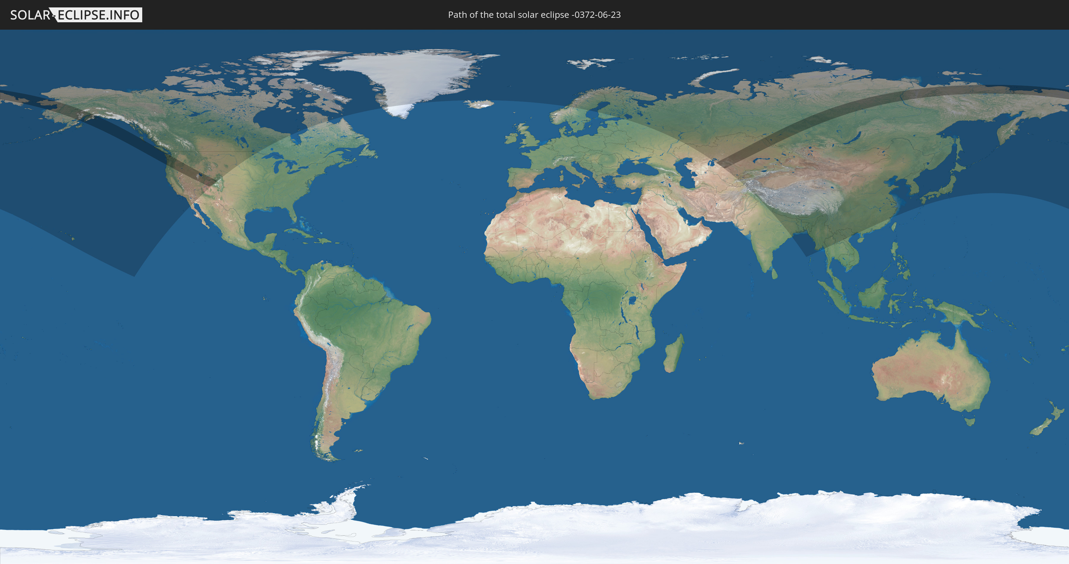
Die Sonnenfinsternis am 06/23/-0372 kann man in 30 Ländern als partielle Sonnenfinsternis beobachten.
Der Finsternispfad verläuft durch 5 Länder. Nur in diesen Ländern ist sie als total Sonnenfinsternis zu sehen.
In den folgenden Ländern ist die Sonnenfinsternis total zu sehen
 Russia
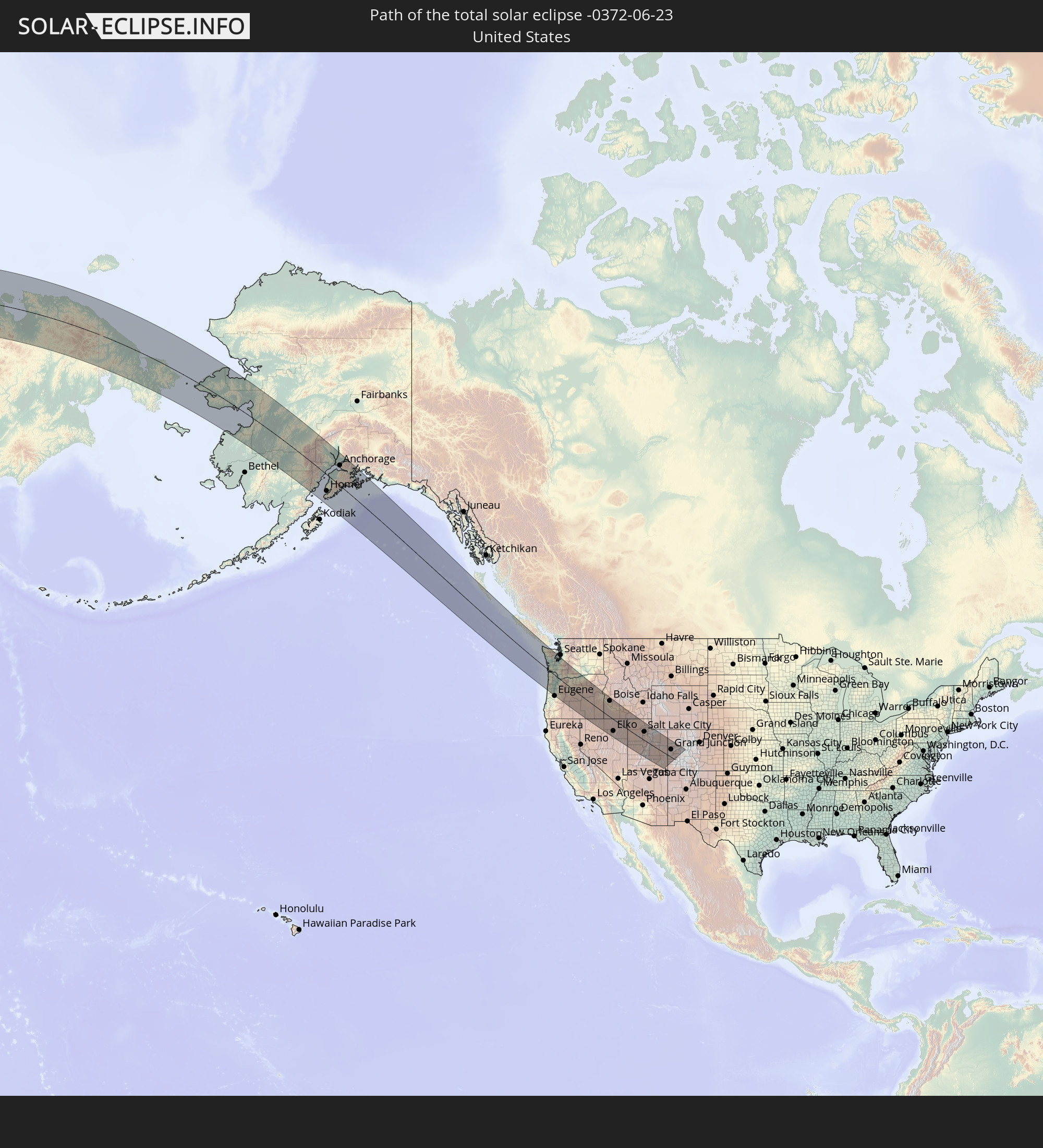 United States
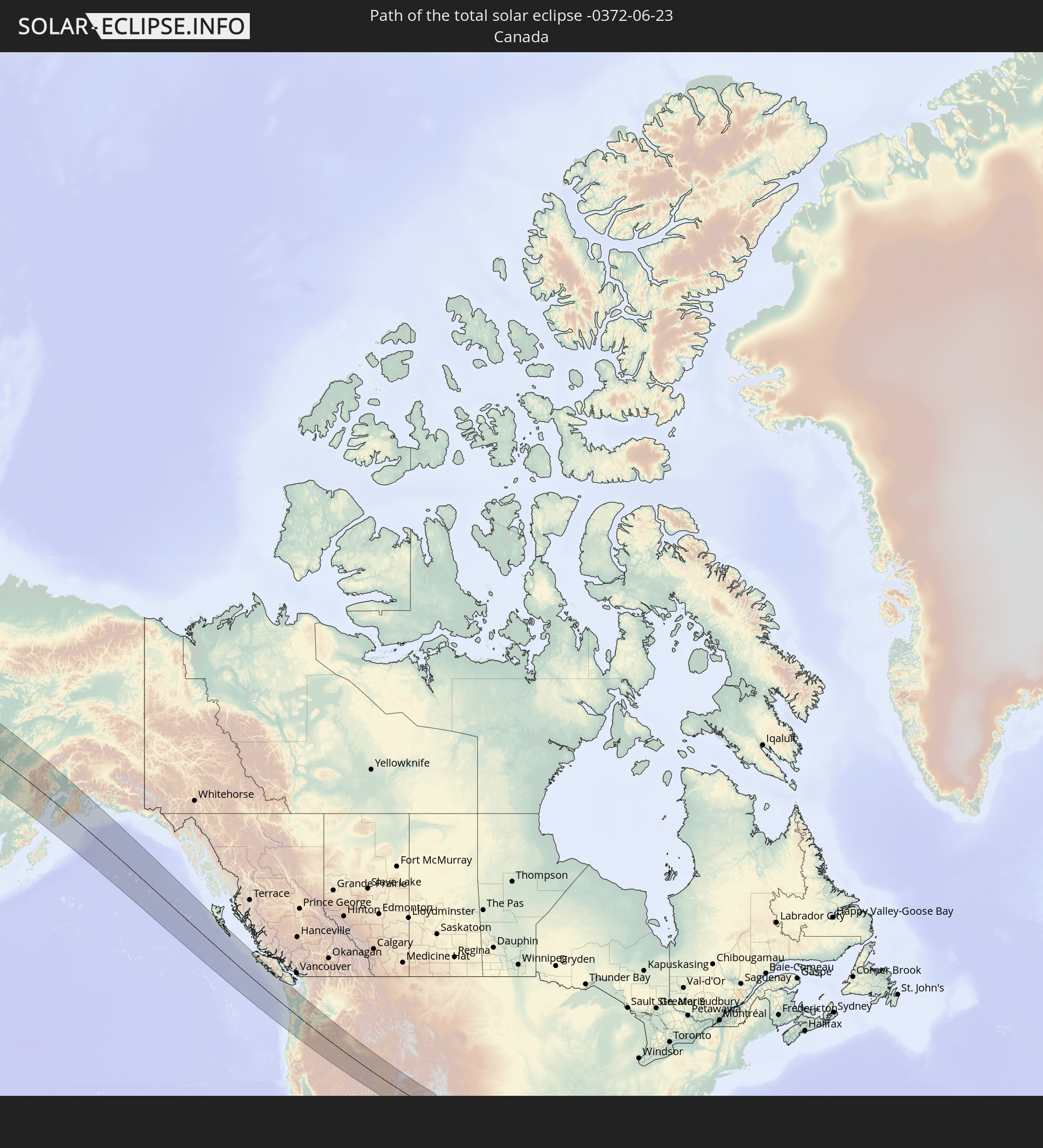 Canada
 Kazakhstan
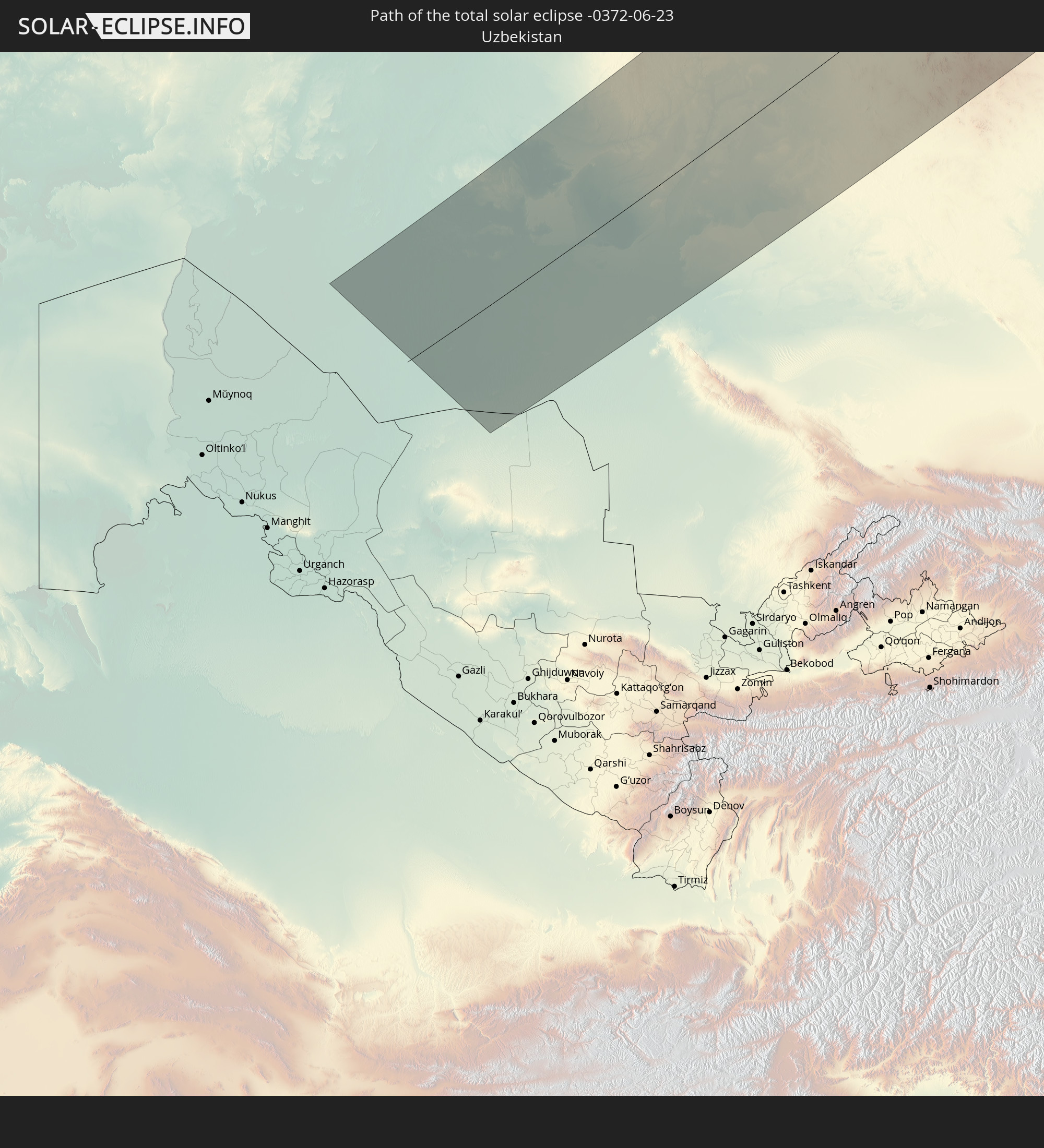 Uzbekistan
In den folgenden Ländern ist die Sonnenfinsternis partiell zu sehen
 Russia
 United States
 United States Minor Outlying Islands
 Canada
 Mexico
 Greenland
 Iceland
 Svalbard and Jan Mayen
 Norway
 Sweden
 Finland
 Kazakhstan
 Uzbekistan
 Afghanistan
 Pakistan
 Tajikistan
 India
India
 Kyrgyzstan
 China
China
 Nepal
Nepal
 Mongolia
 Bangladesh
 Bhutan
 Myanmar
 Thailand
 Laos
Laos
 Vietnam
 Japan
Japan
 North Korea
 South Korea
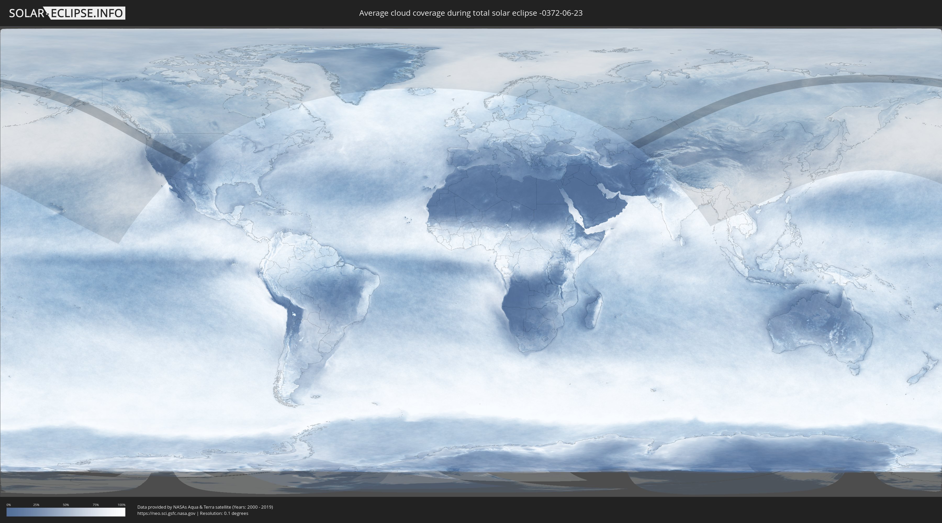
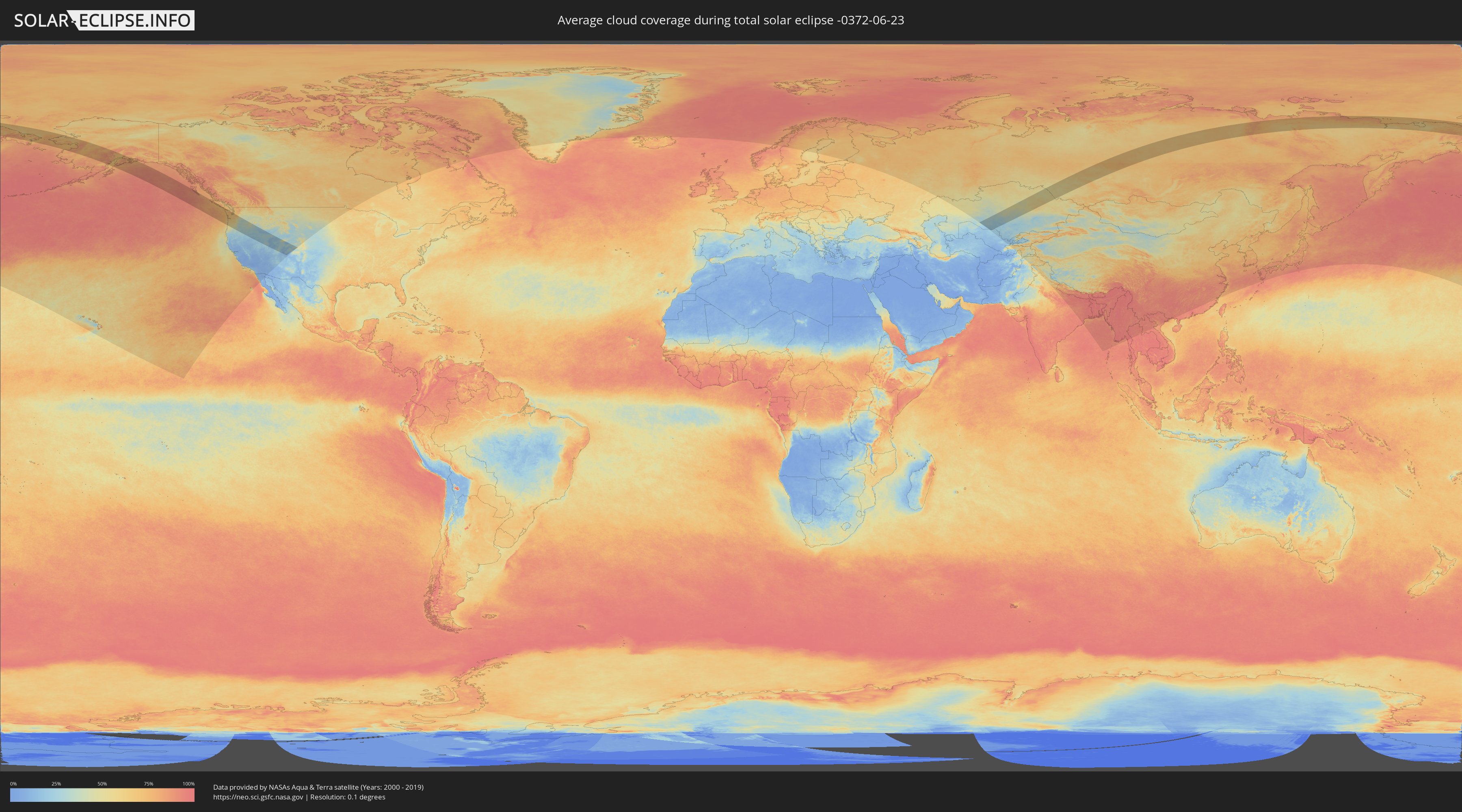
How will be the weather during the total solar eclipse on 06/23/-0372?
Where is the best place to see the total solar eclipse of 06/23/-0372?
The following maps show the average cloud coverage for the day of the total solar eclipse.
With the help of these maps, it is possible to find the place along the eclipse path, which has the best
chance of a cloudless sky.
Nevertheless, you should consider local circumstances and inform about the weather of your chosen
observation site.
The data is provided by NASAs satellites
AQUA and TERRA.
The cloud maps are averaged over a period of 19 years (2000 - 2019).
Detailed country maps
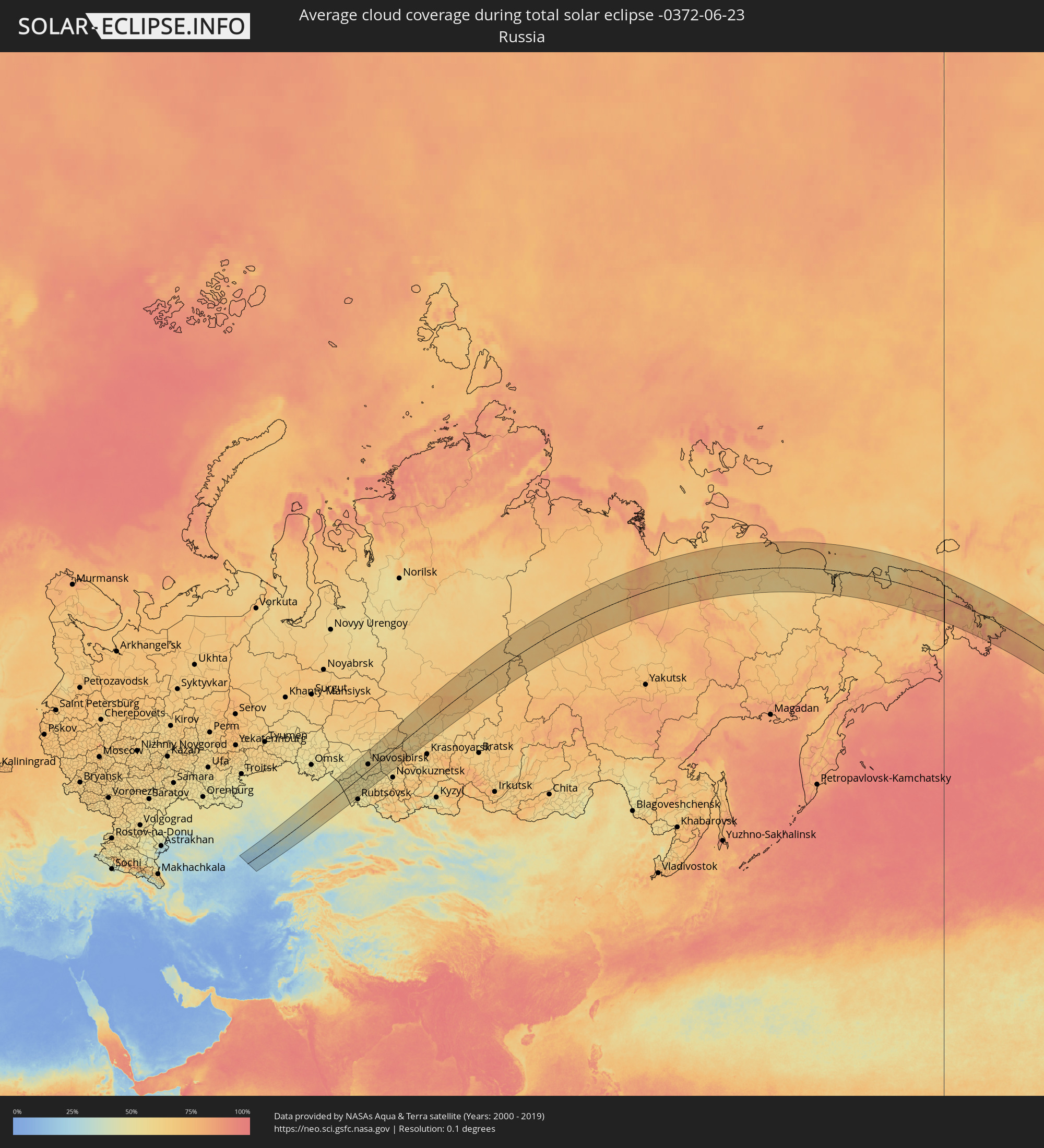 Russia
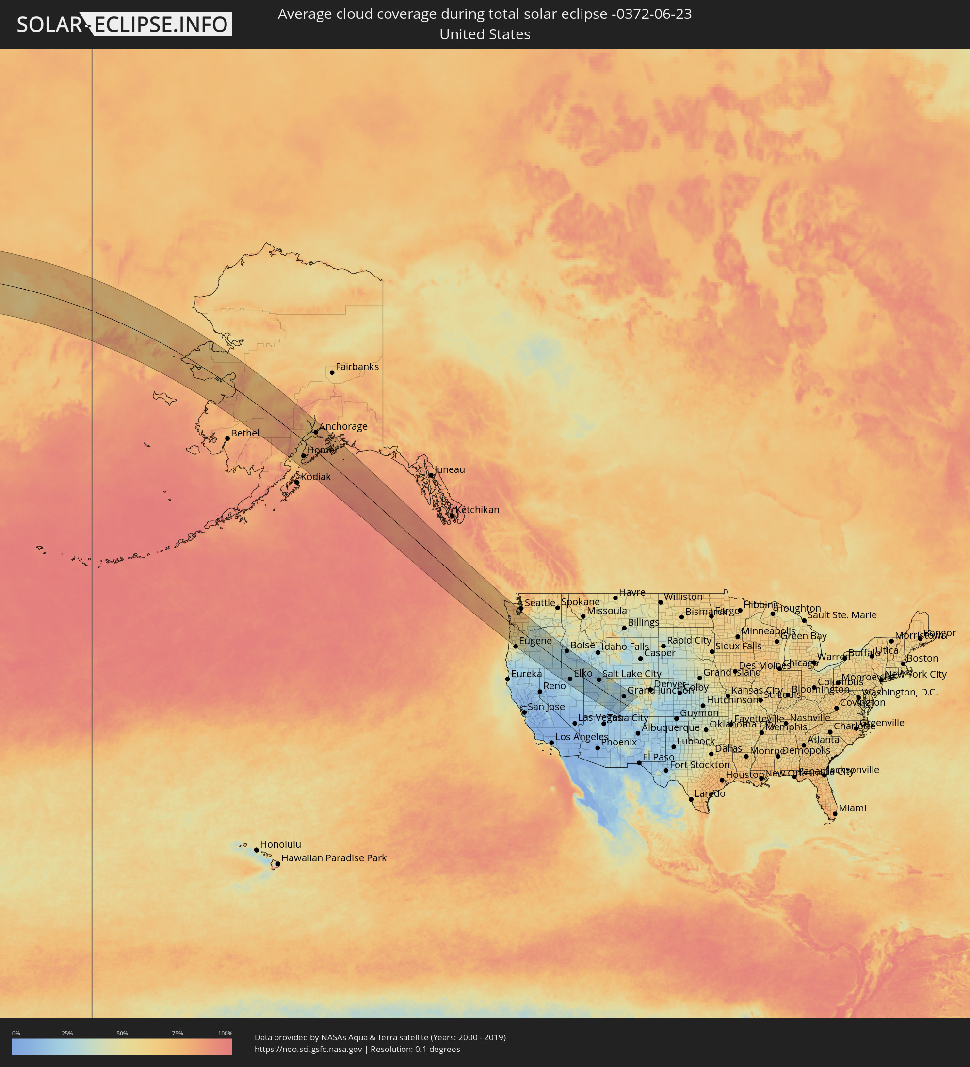 United States
 Canada
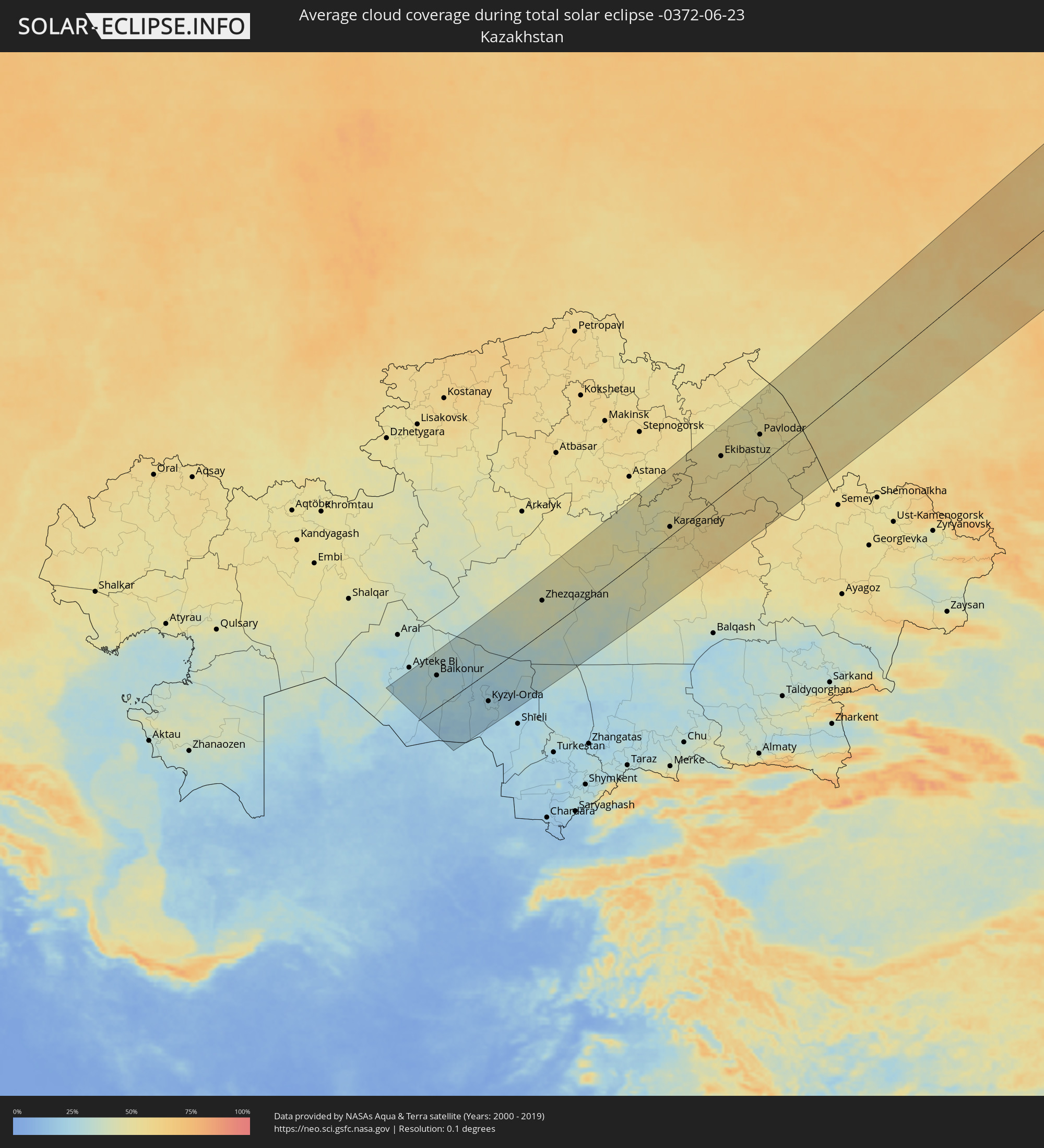 Kazakhstan
 Uzbekistan
Cities inside the path of the eclipse
The following table shows all locations with a population of more than 5,000 inside the eclipse path. Cities which have more than 100,000 inhabitants are marked bold. A click at the locations opens a detailed map.
| City | Type | Eclipse duration | Local time of max. eclipse | Distance to central line | Ø Cloud coverage |
|
Anchorage, Alaska
|
total | - | 15:54:30 UTC-10:00 | 105 km | 74% |
|
Knik-Fairview, Alaska
|
total | - | 15:54:08 UTC-10:00 | 141 km | 79% |
|
Eagle River, Alaska
|
total | - | 15:54:28 UTC-10:00 | 125 km | 76% |
|
Newport, Oregon
|
total | - | 18:25:25 UTC-08:00 | 157 km | 57% |
|
Astoria, Oregon
|
total | - | 18:23:11 UTC-08:00 | 26 km | 66% |
|
Aberdeen, Washington
|
total | - | 18:22:03 UTC-08:00 | 57 km | 70% |
|
Dallas, Oregon
|
total | - | 18:24:54 UTC-08:00 | 97 km | 57% |
|
Corvallis, Oregon
|
total | - | 18:25:23 UTC-08:00 | 127 km | 53% |
|
McMinnville, Oregon
|
total | - | 18:24:28 UTC-08:00 | 68 km | 59% |
|
Shelton, Washington
|
total | - | 18:21:35 UTC-08:00 | 113 km | 66% |
|
Salem, Oregon
|
total | - | 18:24:49 UTC-08:00 | 82 km | 56% |
|
Hillsboro, Oregon
|
total | - | 18:23:59 UTC-08:00 | 28 km | 61% |
|
Newberg, Oregon
|
total | - | 18:24:18 UTC-08:00 | 48 km | 58% |
|
Centralia, Washington
|
total | - | 18:22:17 UTC-08:00 | 77 km | 67% |
|
Longview, Washington
|
total | - | 18:23:06 UTC-08:00 | 28 km | 64% |
|
Lebanon, Oregon
|
total | - | 18:25:21 UTC-08:00 | 111 km | 52% |
|
Olympia, Washington
|
total | - | 18:21:49 UTC-08:00 | 107 km | 67% |
|
Woodburn, Oregon
|
total | - | 18:24:30 UTC-08:00 | 55 km | 55% |
|
Saint Helens, Oregon
|
total | - | 18:23:28 UTC-08:00 | 10 km | 58% |
|
Silverton, Oregon
|
total | - | 18:24:41 UTC-08:00 | 67 km | 55% |
|
Sweet Home, Oregon
|
total | - | 18:25:31 UTC-08:00 | 115 km | 50% |
|
Portland, Oregon
|
total | - | 18:23:56 UTC-08:00 | 15 km | 61% |
|
Salmon Creek, Washington
|
total | - | 18:23:40 UTC-08:00 | 19 km | 63% |
|
Port Orchard, Washington
|
total | - | 18:21:03 UTC-08:00 | 163 km | 66% |
|
Oregon City, Oregon
|
total | - | 18:24:09 UTC-08:00 | 25 km | 60% |
|
Fort Lewis, Washington
|
total | - | 18:21:40 UTC-08:00 | 130 km | 68% |
|
Tacoma, Washington
|
total | - | 18:21:26 UTC-08:00 | 149 km | 67% |
|
Klahanie, Washington
|
total | - | 18:21:10 UTC-08:00 | 163 km | 63% |
|
Gresham, Oregon
|
total | - | 18:23:55 UTC-08:00 | 10 km | 64% |
|
South Hill, Washington
|
total | - | 18:21:34 UTC-08:00 | 147 km | 69% |
|
Sandy, Oregon
|
total | - | 18:24:02 UTC-08:00 | 23 km | 62% |
|
Auburn, Washington
|
total | - | 18:21:19 UTC-08:00 | 163 km | 68% |
|
Bend, Oregon
|
total | - | 18:25:41 UTC-08:00 | 75 km | 32% |
|
The Dalles, Oregon
|
total | - | 18:23:33 UTC-08:00 | 69 km | 39% |
|
Redmond, Oregon
|
total | - | 18:25:22 UTC-08:00 | 50 km | 29% |
|
Prineville, Oregon
|
total | - | 18:25:15 UTC-08:00 | 31 km | 30% |
|
Baker City, Oregon
|
total | - | 18:23:51 UTC-08:00 | 156 km | 34% |
|
Ontario, Oregon
|
total | - | 19:24:36 UTC-07:00 | 132 km | 29% |
|
Caldwell, Idaho
|
total | - | 19:24:59 UTC-07:00 | 113 km | 24% |
|
Nampa, Idaho
|
total | - | 19:25:07 UTC-07:00 | 109 km | 23% |
|
Meridian, Idaho
|
total | - | 19:24:58 UTC-07:00 | 124 km | 21% |
|
Boise, Idaho
|
total | - | 19:24:54 UTC-07:00 | 133 km | 23% |
|
Elko, Nevada
|
total | - | 18:28:16 UTC-08:00 | 100 km | 24% |
|
Mountain Home, Idaho
|
total | - | 19:25:21 UTC-07:00 | 113 km | 23% |
|
Spring Creek, Nevada
|
total | - | 18:28:20 UTC-08:00 | 101 km | 23% |
|
Jerome, Idaho
|
total | - | 19:25:28 UTC-07:00 | 132 km | 20% |
|
Twin Falls, Idaho
|
total | - | 19:25:39 UTC-07:00 | 122 km | 22% |
|
Burley, Idaho
|
total | - | 19:25:27 UTC-07:00 | 151 km | 22% |
|
Grantsville, Utah
|
total | - | 19:27:17 UTC-07:00 | 39 km | 21% |
|
Tooele, Utah
|
total | - | 19:27:18 UTC-07:00 | 36 km | 26% |
|
Magna, Utah
|
total | - | 19:27:00 UTC-07:00 | 61 km | 22% |
|
Brigham City, Utah
|
total | - | 19:26:01 UTC-07:00 | 140 km | 19% |
|
Eagle Mountain, Utah
|
total | - | 19:27:26 UTC-07:00 | 35 km | 25% |
|
Ogden, Utah
|
total | - | 19:26:20 UTC-07:00 | 117 km | 18% |
|
Layton, Utah
|
total | - | 19:26:32 UTC-07:00 | 101 km | 18% |
|
West Jordan, Utah
|
total | - | 19:27:03 UTC-07:00 | 62 km | 21% |
|
Salt Lake City, Utah
|
total | - | 19:26:51 UTC-07:00 | 77 km | 18% |
|
Centerville, Utah
|
total | - | 19:26:40 UTC-07:00 | 92 km | 19% |
|
Lehi, Utah
|
total | - | 19:27:16 UTC-07:00 | 46 km | 22% |
|
Payson, Utah
|
total | - | 19:27:38 UTC-07:00 | 23 km | 23% |
|
Provo, Utah
|
total | - | 19:27:22 UTC-07:00 | 39 km | 19% |
|
Heber City, Utah
|
total | - | 19:26:57 UTC-07:00 | 75 km | 21% |
|
Fruita, Colorado
|
total | - | 19:27:16 UTC-07:00 | 73 km | 23% |
|
Grand Junction, Colorado
|
total | - | 19:27:17 UTC-07:00 | 70 km | 27% |
|
Delta, Colorado
|
total | - | 19:27:24 UTC-07:00 | 62 km | 26% |
|
Montrose, Colorado
|
total | - | 19:27:36 UTC-07:00 | 45 km | 27% |
|
Rifle, Colorado
|
total | - | 19:26:24 UTC-07:00 | 150 km | 29% |
|
Tyuratam, Baikonur
|
total | - | 04:27:20 UTC+04:21 | 92 km | 28% |
|
Baikonur, Baikonur
|
total | - | 04:27:17 UTC+04:21 | 89 km | 29% |
|
Zhosaly, Qyzylorda
|
total | - | 04:26:47 UTC+04:21 | 44 km | 25% |
|
Dzhalagash, Qyzylorda
|
total | - | 04:26:05 UTC+04:21 | 21 km | 22% |
|
Terenozek, Qyzylorda
|
total | - | 04:25:54 UTC+04:21 | 43 km | 24% |
|
Kyzyl-Orda, Qyzylorda
|
total | - | 04:25:26 UTC+04:21 | 80 km | 26% |
|
Kyzylorda, Qyzylorda
|
total | - | 04:25:26 UTC+04:21 | 80 km | 24% |
|
Tasböget, Qyzylorda
|
total | - | 04:25:20 UTC+04:21 | 89 km | 25% |
|
Zhezqazghan, Qaraghandy
|
total | - | 04:27:48 UTC+04:21 | 83 km | 43% |
|
Qarazhal, Qaraghandy
|
total | - | 04:26:58 UTC+04:21 | 33 km | 44% |
|
Kīevka, Qaraghandy
|
total | - | 04:29:32 UTC+04:21 | 132 km | 45% |
|
Atasū, Qaraghandy
|
total | - | 04:27:31 UTC+04:21 | 12 km | 47% |
|
Osakarovka, Qaraghandy
|
total | - | 04:29:37 UTC+04:21 | 112 km | 48% |
|
Shakhan, Qaraghandy
|
total | - | 04:28:38 UTC+04:21 | 44 km | 49% |
|
Novodolīnskīy, Qaraghandy
|
total | - | 04:28:28 UTC+04:21 | 31 km | 46% |
|
Aktau, Qaraghandy
|
total | - | 04:26:19 UTC+04:21 | 123 km | 46% |
|
Sorang, Qaraghandy
|
total | - | 04:28:33 UTC+04:21 | 35 km | 49% |
|
Aqadyr, Qaraghandy
|
total | - | 04:26:36 UTC+04:21 | 103 km | 47% |
|
Abay, Qaraghandy
|
total | - | 04:28:20 UTC+04:21 | 18 km | 50% |
|
Aqtas, Qaraghandy
|
total | - | 04:28:30 UTC+04:21 | 31 km | 52% |
|
Temirtau, Qaraghandy
|
total | - | 04:28:51 UTC+04:21 | 51 km | 52% |
|
Aqtaū, Qaraghandy
|
total | - | 04:29:03 UTC+04:21 | 62 km | 50% |
|
Karagandy, Qaraghandy
|
total | - | 04:28:30 UTC+04:21 | 26 km | 53% |
|
Ekibastuz, Pavlodar
|
total | - | 04:30:27 UTC+04:21 | 92 km | 52% |
|
Qarqaraly, Qaraghandy
|
total | - | 04:27:20 UTC+04:21 | 117 km | 59% |
|
Bayanaul, Pavlodar
|
total | - | 04:29:06 UTC+04:21 | 14 km | 59% |
|
Mayqayyng, Pavlodar
|
total | - | 04:29:59 UTC+04:21 | 51 km | 53% |
|
Qalqaman, Pavlodar
|
total | - | 04:30:36 UTC+04:21 | 82 km | 50% |
|
Leninskiy, Pavlodar
|
total | - | 04:30:51 UTC+04:21 | 73 km | 47% |
|
Aksu, Pavlodar
|
total | - | 04:30:32 UTC+04:21 | 49 km | 49% |
|
Pavlodar, Pavlodar
|
total | - | 04:30:51 UTC+04:21 | 67 km | 51% |
|
Karasuk, Novosibirsk
|
total | - | 06:22:16 UTC+06:11 | 145 km | 50% |
|
Kūrchatov, Pavlodar
|
total | - | 04:28:27 UTC+04:21 | 135 km | 51% |
|
Slavgorod, Altai Krai
|
total | - | 06:21:07 UTC+06:11 | 58 km | 53% |
|
Kulunda, Altai Krai
|
total | - | 06:20:28 UTC+06:11 | 6 km | 51% |
|
Klyuchi, Altai Krai
|
total | - | 06:19:59 UTC+06:11 | 32 km | 54% |
|
Krasnozërskoye, Novosibirsk
|
total | - | 06:22:26 UTC+06:11 | 115 km | 53% |
|
Mikhaylovskoye, Altai Krai
|
total | - | 06:19:18 UTC+06:11 | 92 km | 58% |
|
Blagoveshchenka, Altai Krai
|
total | - | 06:20:42 UTC+06:11 | 23 km | 54% |
|
Rodino, Altai Krai
|
total | - | 06:20:11 UTC+06:11 | 57 km | 52% |
|
Volchikha, Altai Krai
|
total | - | 06:19:28 UTC+06:11 | 103 km | 56% |
|
Zav’yalovo, Altai Krai
|
total | - | 06:20:34 UTC+06:11 | 56 km | 52% |
|
Chulym, Novosibirsk
|
total | - | 06:23:51 UTC+06:11 | 137 km | 57% |
|
Kamen’-na-Obi, Altai Krai
|
total | - | 06:21:53 UTC+06:11 | 11 km | 52% |
|
Mamontovo, Altai Krai
|
total | - | 06:20:18 UTC+06:11 | 98 km | 52% |
|
Ordynskoye, Novosibirsk
|
total | - | 06:22:41 UTC+06:11 | 41 km | 51% |
|
Kochenëvo, Novosibirsk
|
total | - | 06:23:37 UTC+06:11 | 78 km | 57% |
|
Suzun, Novosibirsk
|
total | - | 06:21:47 UTC+06:11 | 32 km | 58% |
|
Ob’, Novosibirsk
|
total | - | 06:23:32 UTC+06:11 | 58 km | 58% |
|
Kolyvan’, Novosibirsk
|
total | - | 06:24:00 UTC+06:11 | 80 km | 58% |
|
Novosibirsk, Novosibirsk
|
total | - | 06:23:36 UTC+06:11 | 50 km | 63% |
|
Pavlovsk, Altai Krai
|
total | - | 06:21:03 UTC+06:11 | 100 km | 57% |
|
Berdsk, Novosibirsk
|
total | - | 06:23:10 UTC+06:11 | 26 km | 57% |
|
Topchikha, Altai Krai
|
total | - | 06:20:18 UTC+06:11 | 150 km | 55% |
|
Kol’tsovo, Novosibirsk
|
total | - | 06:23:25 UTC+06:11 | 31 km | 59% |
|
Iskitim, Novosibirsk
|
total | - | 06:22:58 UTC+06:11 | 16 km | 57% |
|
Linëvo, Novosibirsk
|
total | - | 06:22:42 UTC+06:11 | 25 km | 59% |
|
Cherepanovo, Novosibirsk
|
total | - | 06:22:21 UTC+06:11 | 39 km | 56% |
|
Tal’menka, Altai Krai
|
total | - | 06:21:44 UTC+06:11 | 83 km | 58% |
|
Moshkovo, Novosibirsk
|
total | - | 06:23:57 UTC+06:11 | 45 km | 56% |
|
Novosilikatnyy, Altai Krai
|
total | - | 06:20:59 UTC+06:11 | 128 km | 56% |
|
Sibirskiy, Altai Krai
|
total | - | 06:21:22 UTC+06:11 | 111 km | 58% |
|
Barnaul, Altai Krai
|
total | - | 06:21:03 UTC+06:11 | 129 km | 58% |
|
Beloyarsk, Altai Krai
|
total | - | 06:21:10 UTC+06:11 | 128 km | 57% |
|
Gornyy, Novosibirsk
|
total | - | 06:23:39 UTC+06:11 | 17 km | 57% |
|
Mel’nikovo, Tomsk
|
total | - | 06:25:49 UTC+06:11 | 131 km | 62% |
|
Maslyanino, Novosibirsk
|
total | - | 06:22:29 UTC+06:11 | 63 km | 57% |
|
Toguchin, Novosibirsk
|
total | - | 06:23:48 UTC+06:11 | 8 km | 54% |
|
Bolotnoye, Novosibirsk
|
total | - | 06:24:28 UTC+06:11 | 46 km | 58% |
|
Yurga, Kemerovo
|
total | - | 06:24:32 UTC+06:11 | 32 km | 55% |
|
Zarinsk, Altai Krai
|
total | - | 06:21:30 UTC+06:11 | 148 km | 54% |
|
Tomsk, Tomsk
|
total | - | 06:25:42 UTC+06:11 | 91 km | 64% |
|
Yashkino, Kemerovo
|
total | - | 06:24:45 UTC+06:11 | 22 km | 61% |
|
Topki, Kemerovo
|
total | - | 06:23:50 UTC+06:11 | 43 km | 57% |
|
Tayga, Kemerovo
|
total | - | 06:25:02 UTC+06:11 | 29 km | 65% |
|
Promyshlennaya, Kemerovo
|
total | - | 06:23:17 UTC+06:11 | 72 km | 57% |
|
Salair, Kemerovo
|
total | - | 06:22:15 UTC+06:11 | 137 km | 60% |
|
Gur’yevsk, Kemerovo
|
total | - | 06:22:19 UTC+06:11 | 138 km | 60% |
|
Anzhero-Sudzhensk, Kemerovo
|
total | - | 06:25:03 UTC+06:11 | 19 km | 64% |
|
Kemerovo, Kemerovo
|
total | - | 06:23:55 UTC+06:11 | 53 km | 57% |
|
Bachatskiy, Kemerovo
|
total | - | 06:22:20 UTC+06:11 | 146 km | 60% |
|
Asino, Tomsk
|
total | - | 06:26:28 UTC+06:11 | 87 km | 62% |
|
Leninsk-Kuznetsky, Kemerovo
|
total | - | 06:22:53 UTC+06:11 | 115 km | 61% |
|
Berëzovskiy, Kemerovo
|
total | - | 06:24:19 UTC+06:11 | 37 km | 63% |
|
Belovo, Kemerovo
|
total | - | 06:22:31 UTC+06:11 | 141 km | 59% |
|
Gramoteino, Kemerovo
|
total | - | 06:22:42 UTC+06:11 | 134 km | 58% |
|
Yaya, Kemerovo
|
total | - | 06:25:15 UTC+06:11 | 8 km | 60% |
|
Inskoy, Kemerovo
|
total | - | 06:22:32 UTC+06:11 | 146 km | 57% |
|
Mariinsk, Kemerovo
|
total | - | 06:25:17 UTC+06:11 | 46 km | 61% |
|
Tisul’, Kemerovo
|
total | - | 06:24:35 UTC+06:11 | 107 km | 59% |
|
Tyazhinskiy, Kemerovo
|
total | - | 06:25:09 UTC+06:11 | 83 km | 60% |
|
Dubinino, Krasnoyarskiy
|
total | - | 06:24:24 UTC+06:11 | 148 km | 59% |
|
Sharypovo, Krasnoyarskiy
|
total | - | 06:24:17 UTC+06:11 | 159 km | 61% |
|
Bogotol, Krasnoyarskiy
|
total | - | 06:25:20 UTC+06:11 | 114 km | 61% |
|
Achinsk, Krasnoyarskiy
|
total | - | 06:25:30 UTC+06:11 | 145 km | 64% |
|
Yeniseysk, Krasnoyarskiy
|
total | - | 06:29:08 UTC+06:11 | 19 km | 65% |
|
Lesosibirsk, Krasnoyarskiy
|
total | - | 06:28:49 UTC+06:11 | 49 km | 65% |
|
Aykhal, Sakha
|
total | - | 09:14:21 UTC+08:38 | 72 km | 66% |
|
Udachny, Sakha
|
total | - | 09:15:30 UTC+08:38 | 96 km | 66% |