Total solar eclipse of 10/14/-0396
| Day of week: | Tuesday |
| Maximum duration of eclipse: | 03m39s |
| Maximum width of eclipse path: | 165 km |
| Saros cycle: | 66 |
| Coverage: | 100% |
| Magnitude: | 1.0463 |
| Gamma: | -0.3782 |
Wo kann man die Sonnenfinsternis vom 10/14/-0396 sehen?

Die Sonnenfinsternis am 10/14/-0396 kann man in 59 Ländern als partielle Sonnenfinsternis beobachten.
Der Finsternispfad verläuft durch 3 Länder. Nur in diesen Ländern ist sie als total Sonnenfinsternis zu sehen.
In den folgenden Ländern ist die Sonnenfinsternis total zu sehen
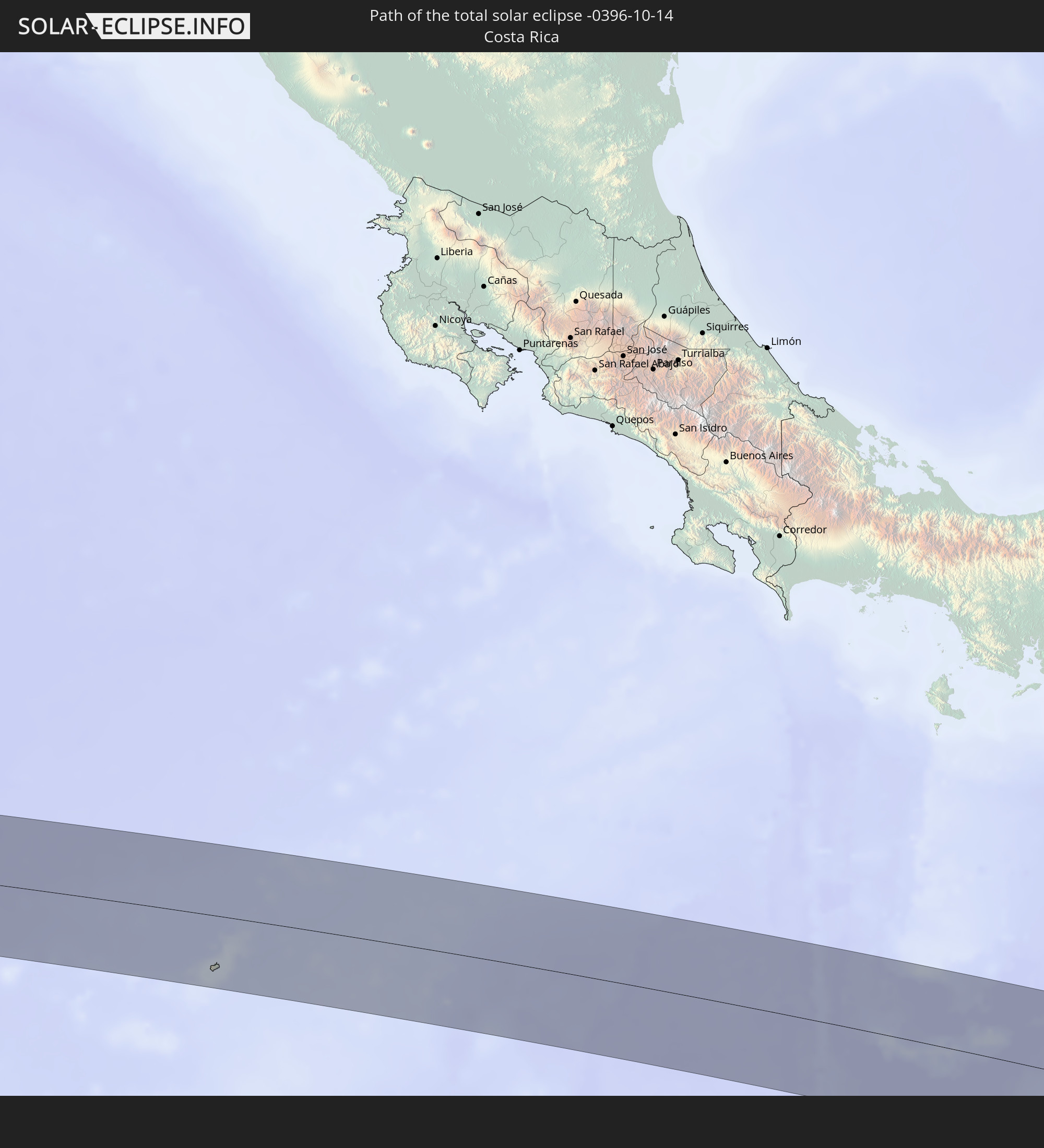 Costa Rica
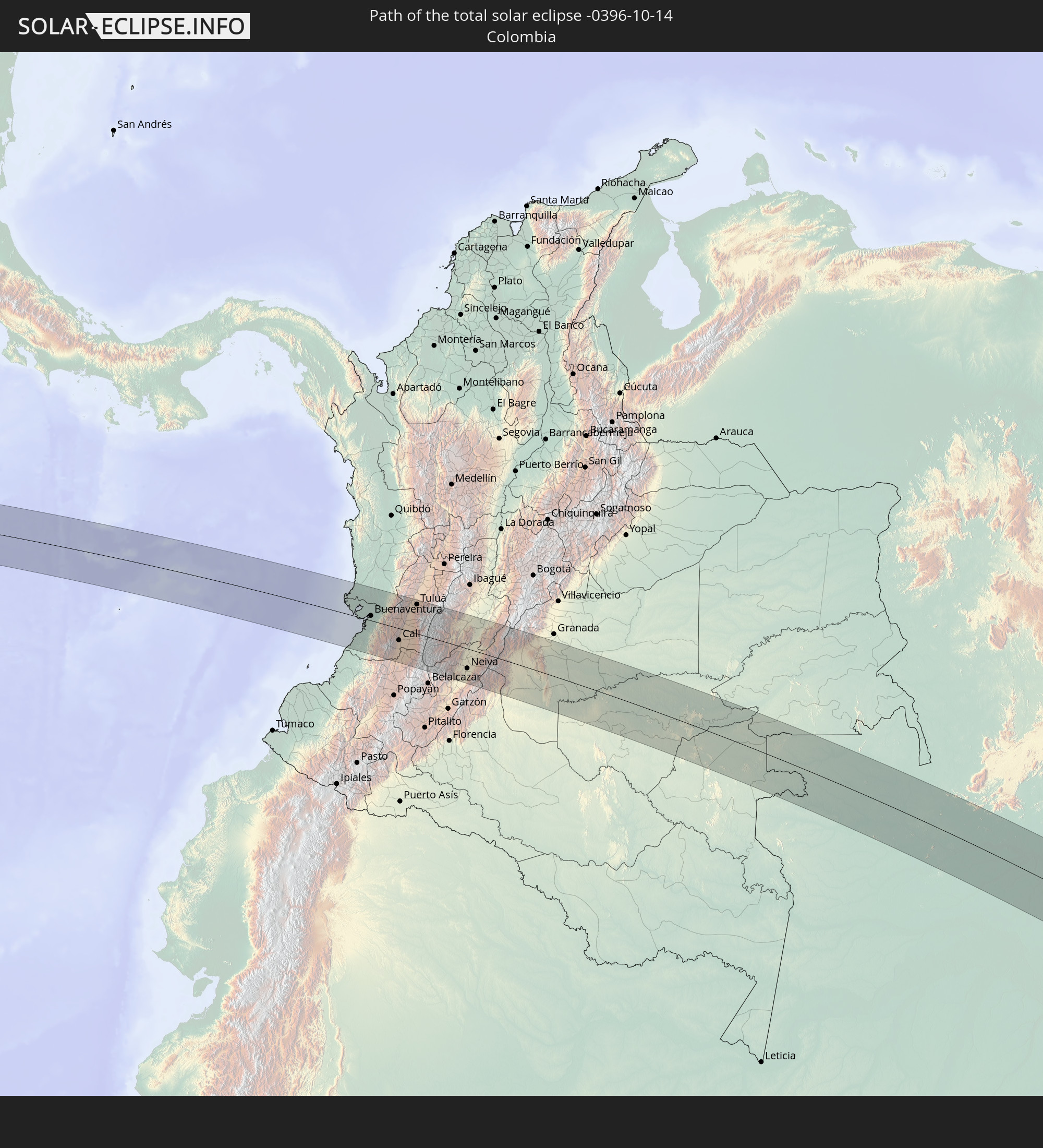 Colombia
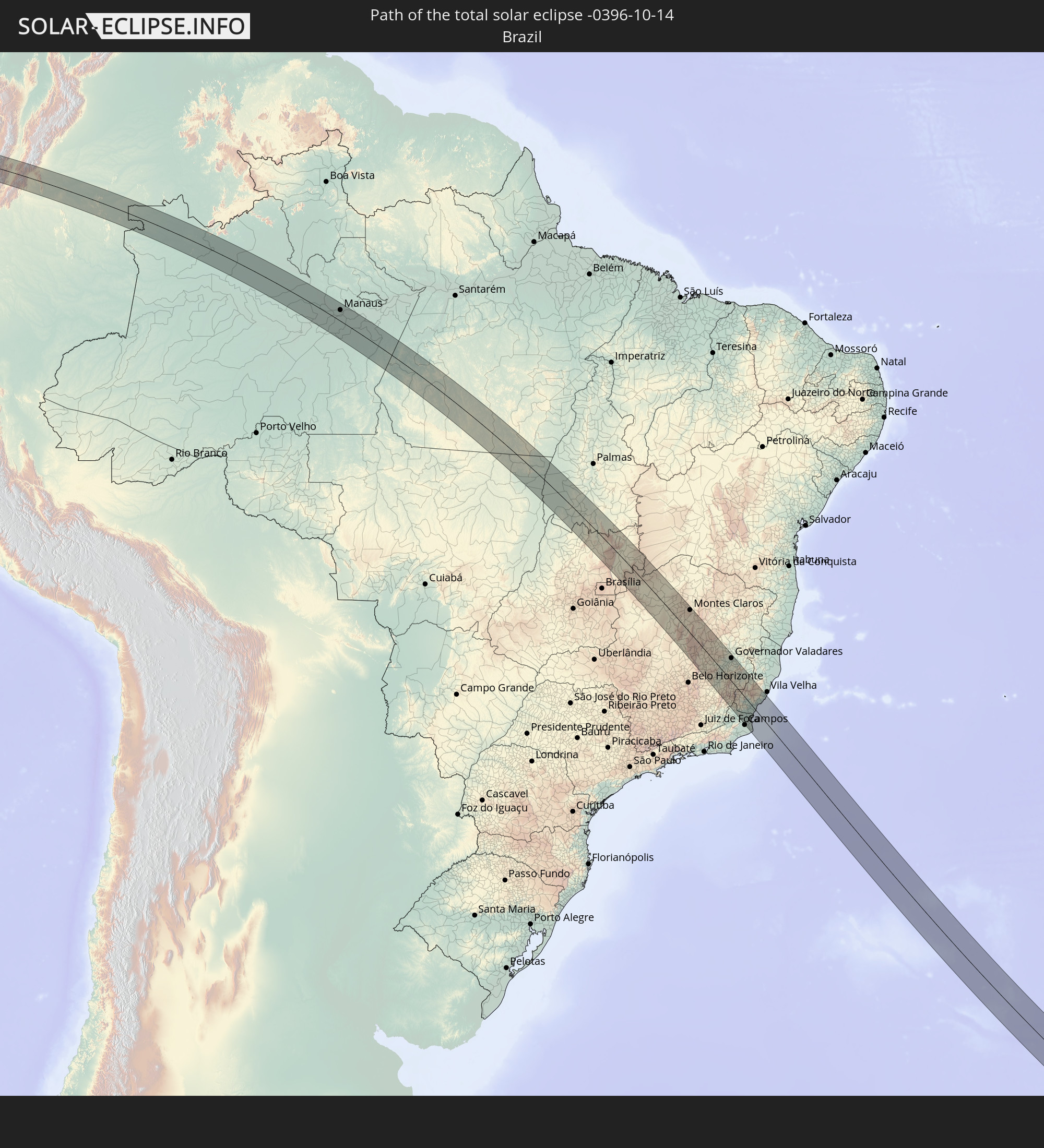 Brazil
In den folgenden Ländern ist die Sonnenfinsternis partiell zu sehen
 Antarctica
 United States
 United States Minor Outlying Islands
 Chile
Chile
 Ecuador
 El Salvador
 Honduras
 Nicaragua
 Costa Rica
 Cuba
Cuba
 Panama
 Colombia
 Cayman Islands
 Peru
Peru
 The Bahamas
 Jamaica
 Haiti
Haiti
 Brazil
 Argentina
 Venezuela
 Turks and Caicos Islands
 Dominican Republic
 Aruba
Aruba
 Bolivia
 Puerto Rico
 United States Virgin Islands
 Bermuda
 British Virgin Islands
 Anguilla
 Collectivity of Saint Martin
 Saint Barthélemy
 Saint Kitts and Nevis
 Paraguay
 Antigua and Barbuda
 Montserrat
 Trinidad and Tobago
 Guadeloupe
 Grenada
 Dominica
 Saint Vincent and the Grenadines
 Falkland Islands
 Guyana
 Martinique
 Saint Lucia
 Barbados
 Uruguay
 Suriname
 French Guiana
 South Georgia and the South Sandwich Islands
 Saint Helena, Ascension and Tristan da Cunha
 Bouvet Island
 Namibia
 South Africa
 Botswana
 Zimbabwe
 Lesotho
 Mozambique
 Swaziland
 French Southern and Antarctic Lands
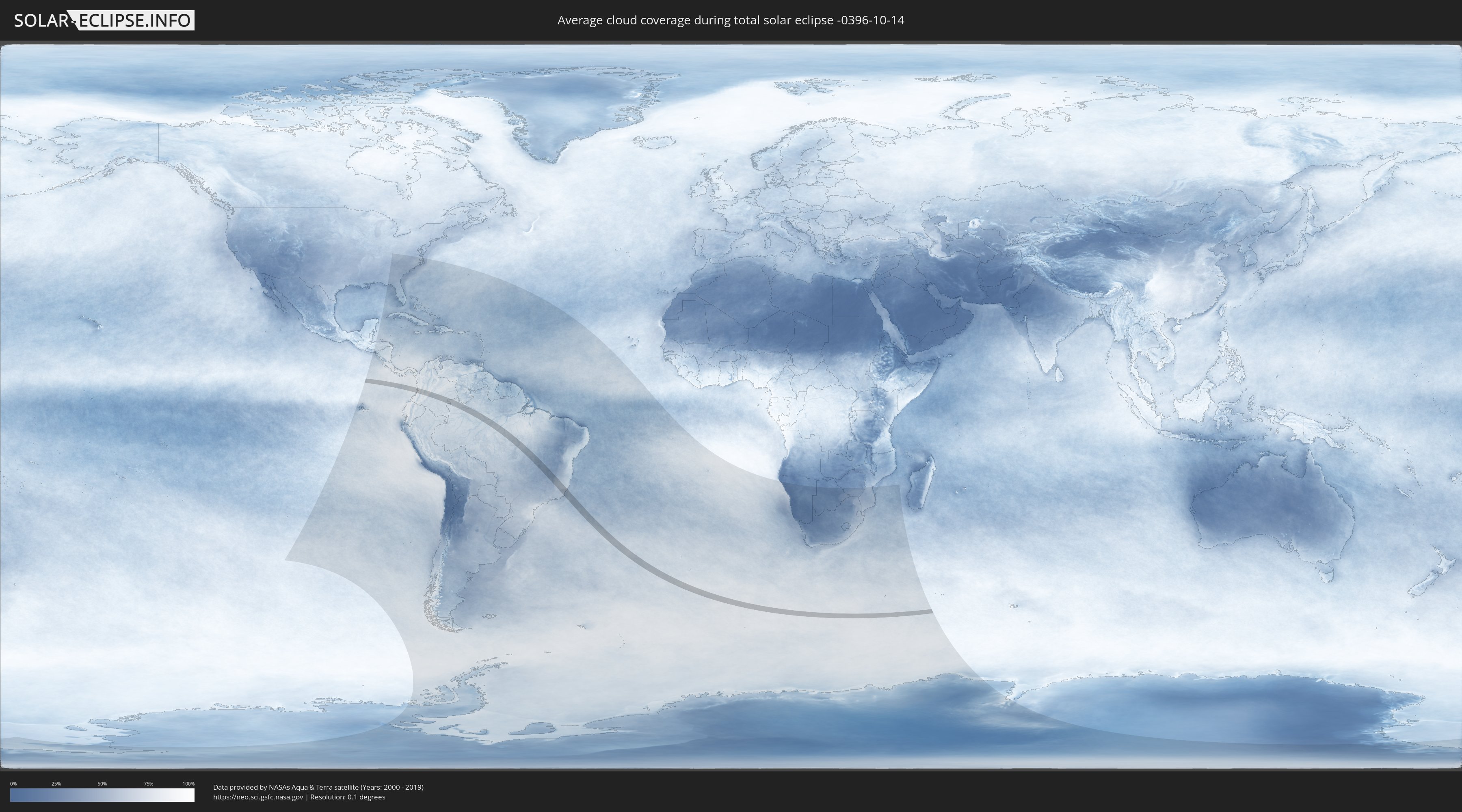
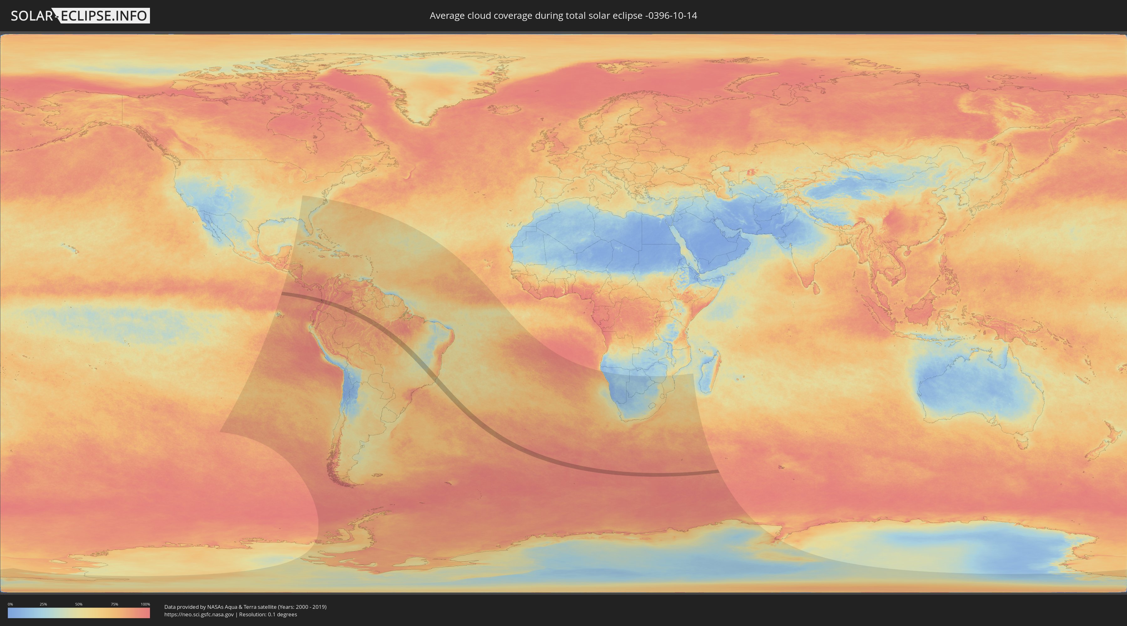
How will be the weather during the total solar eclipse on 10/14/-0396?
Where is the best place to see the total solar eclipse of 10/14/-0396?
The following maps show the average cloud coverage for the day of the total solar eclipse.
With the help of these maps, it is possible to find the place along the eclipse path, which has the best
chance of a cloudless sky.
Nevertheless, you should consider local circumstances and inform about the weather of your chosen
observation site.
The data is provided by NASAs satellites
AQUA and TERRA.
The cloud maps are averaged over a period of 19 years (2000 - 2019).
Detailed country maps
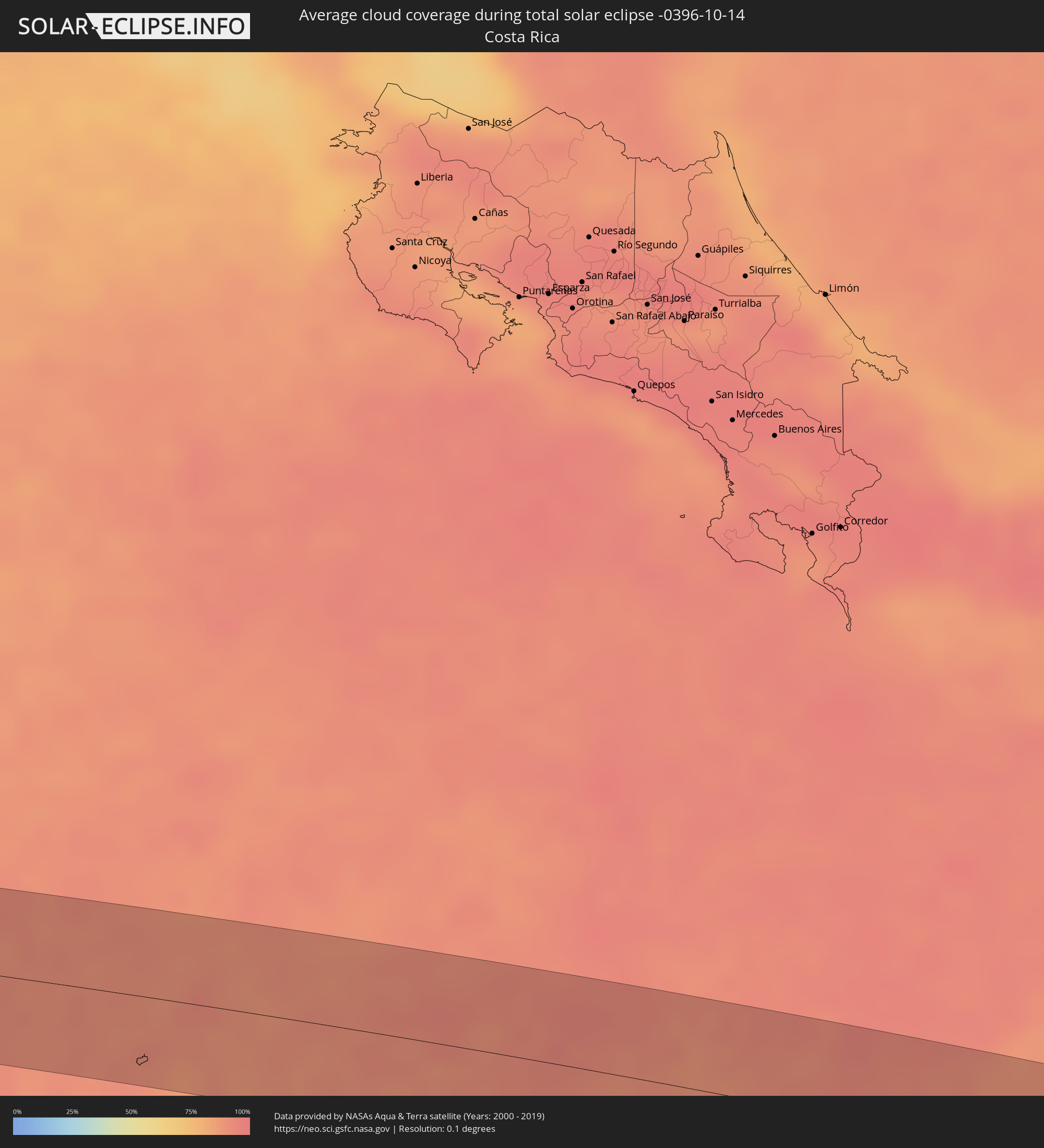 Costa Rica
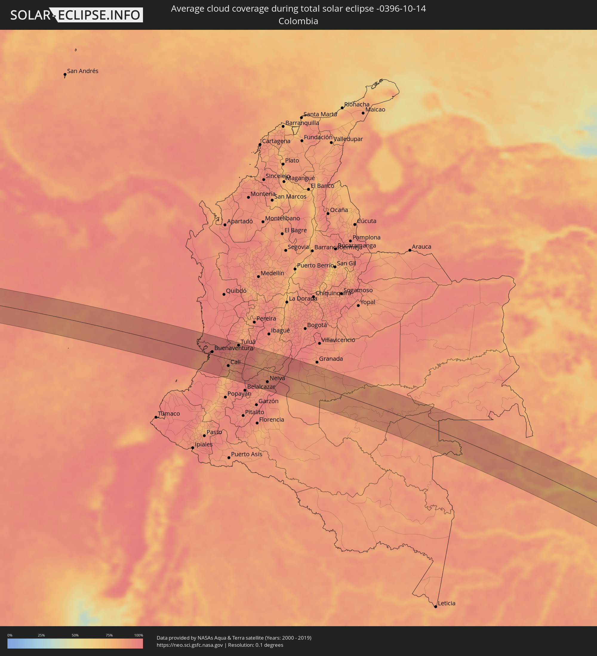 Colombia
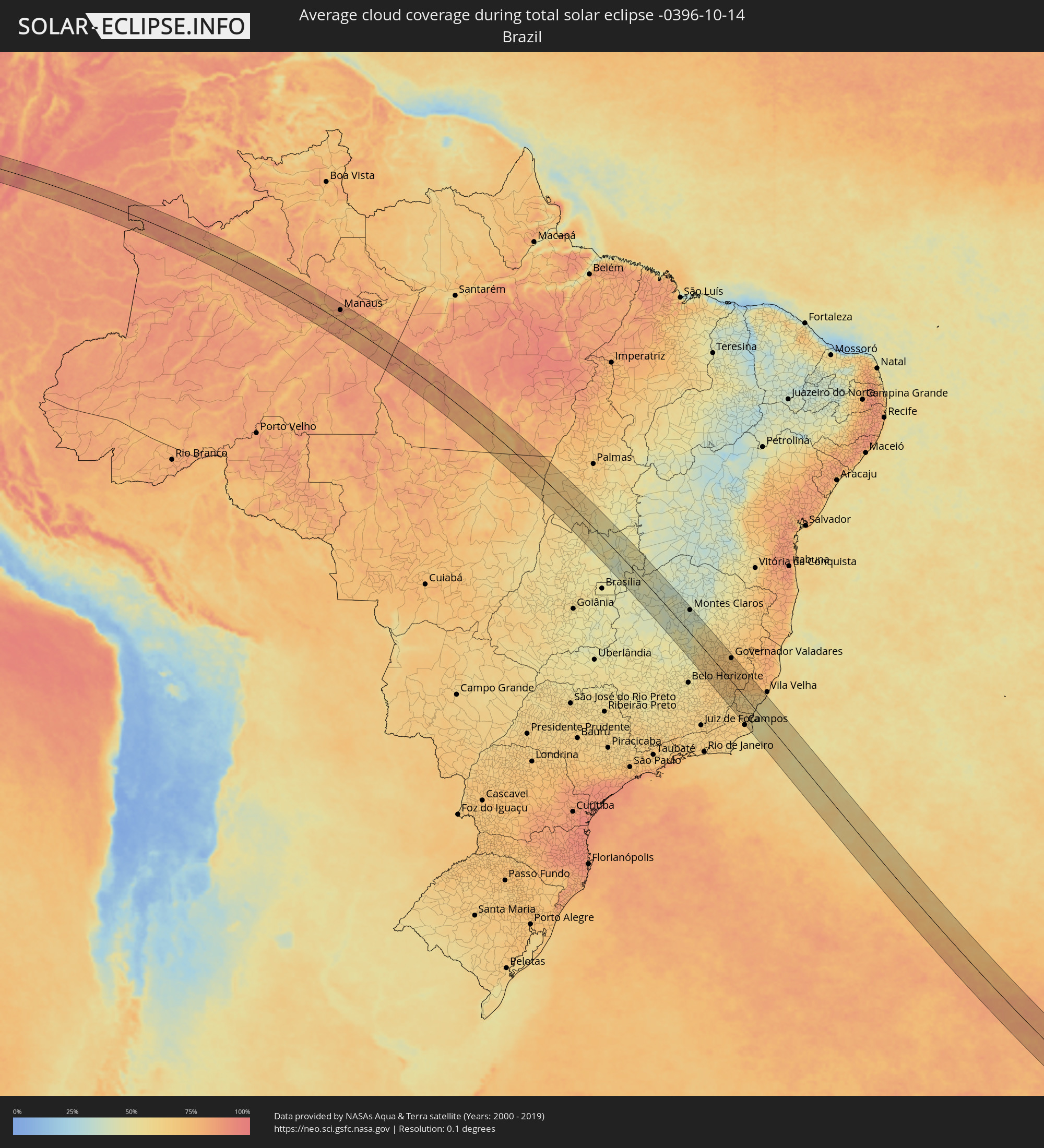 Brazil
Cities inside the path of the eclipse
The following table shows all locations with a population of more than 5,000 inside the eclipse path. Cities which have more than 100,000 inhabitants are marked bold. A click at the locations opens a detailed map.
| City | Type | Eclipse duration | Local time of max. eclipse | Distance to central line | Ø Cloud coverage |
|
Buenaventura, Valle del Cauca
|
total | - | 06:59:45 UTC-04:56 | 9 km | 96% |
|
Buenaventura, Valle del Cauca
|
total | - | 07:00:03 UTC-04:56 | 22 km | 97% |
|
Dagua, Valle del Cauca
|
total | - | 07:00:04 UTC-04:56 | 4 km | 90% |
|
Jamundí, Valle del Cauca
|
total | - | 07:00:30 UTC-04:56 | 42 km | 81% |
|
Cali, Valle del Cauca
|
total | - | 07:00:20 UTC-04:56 | 23 km | 84% |
|
Restrepo, Valle del Cauca
|
total | - | 06:59:57 UTC-04:56 | 18 km | 89% |
|
Yumbo, Valle del Cauca
|
total | - | 07:00:12 UTC-04:56 | 6 km | 88% |
|
Puerto Tejada, Cauca
|
total | - | 07:00:34 UTC-04:56 | 42 km | 84% |
|
Caloto, Cauca
|
total | - | 07:00:46 UTC-04:56 | 62 km | 90% |
|
Yotoco, Valle del Cauca
|
total | - | 06:59:57 UTC-04:56 | 27 km | 87% |
|
Candelaria, Valle del Cauca
|
total | - | 07:00:25 UTC-04:56 | 21 km | 86% |
|
Guacarí, Valle del Cauca
|
total | - | 07:00:04 UTC-04:56 | 18 km | 89% |
|
El Cerrito, Valle del Cauca
|
total | - | 07:00:09 UTC-04:56 | 10 km | 88% |
|
Palmira, Valle del Cauca
|
total | - | 07:00:18 UTC-04:56 | 5 km | 87% |
|
Buga, Valle del Cauca
|
total | - | 06:59:56 UTC-04:56 | 34 km | 88% |
|
Riofrío, Valle del Cauca
|
total | - | 06:59:41 UTC-04:56 | 61 km | 88% |
|
Ginebra, Valle del Cauca
|
total | - | 07:00:07 UTC-04:56 | 16 km | 88% |
|
Corinto, Cauca
|
total | - | 07:00:41 UTC-04:56 | 43 km | 88% |
|
Pradera, Valle del Cauca
|
total | - | 07:00:26 UTC-04:56 | 16 km | 92% |
|
Florida, Valle del Cauca
|
total | - | 07:00:32 UTC-04:56 | 26 km | 92% |
|
San Pedro, Valle del Cauca
|
total | - | 06:59:52 UTC-04:56 | 46 km | 92% |
|
Miranda, Cauca
|
total | - | 07:00:36 UTC-04:56 | 34 km | 93% |
|
Tuluá, Valle del Cauca
|
total | - | 06:59:47 UTC-04:56 | 56 km | 89% |
|
Rioblanco, Tolima
|
total | - | 07:00:30 UTC-04:56 | 13 km | 84% |
|
Planadas, Tolima
|
total | - | 07:00:51 UTC-04:56 | 21 km | 91% |
|
Chaparral, Tolima
|
total | - | 07:00:22 UTC-04:56 | 40 km | 83% |
|
San Antonio, Tolima
|
total | - | 07:00:10 UTC-04:56 | 61 km | 86% |
|
Palermo, Huila
|
total | - | 07:01:14 UTC-04:56 | 47 km | 88% |
|
Campoalegre, Huila
|
total | - | 07:01:29 UTC-04:56 | 65 km | 93% |
|
Neiva, Huila
|
total | - | 07:01:15 UTC-04:56 | 38 km | 90% |
|
Rivera, Huila
|
total | - | 07:01:25 UTC-04:56 | 53 km | 91% |
|
Aipe, Huila
|
total | - | 07:00:57 UTC-04:56 | 5 km | 86% |
|
Natagaima, Tolima
|
total | - | 07:00:36 UTC-04:56 | 42 km | 87% |
|
Puerto Lleras, Meta
|
total | - | 07:01:50 UTC-04:56 | 36 km | 83% |
|
Puerto Yuca, Meta
|
total | - | 07:02:00 UTC-04:56 | 34 km | 82% |
|
San José del Guaviare, Guaviare
|
total | - | 07:02:37 UTC-04:56 | 16 km | 83% |
|
Mitú, Vaupés
|
total | - | 07:05:14 UTC-04:56 | 28 km | 83% |
|
São Gabriel da Cachoeira, Amazonas
|
total | - | 08:02:18 UTC-04:02 | 32 km | 82% |
|
Manacapuru, Amazonas
|
total | - | 08:11:31 UTC-04:02 | 6 km | 77% |
|
Manaquiri, Amazonas
|
total | - | 08:11:46 UTC-04:02 | 9 km | 76% |
|
Iranduba, Amazonas
|
total | - | 08:11:52 UTC-04:02 | 21 km | 77% |
|
Manaus, Amazonas
|
total | - | 08:11:44 UTC-04:02 | 48 km | 82% |
|
Careiro da Várzea, Amazonas
|
total | - | 08:12:03 UTC-04:02 | 51 km | 74% |
|
Borba, Amazonas
|
total | - | 08:14:06 UTC-04:02 | 47 km | 81% |
|
Autazes, Amazonas
|
total | - | 08:13:15 UTC-04:02 | 57 km | 79% |
|
Nova Olinda do Norte, Amazonas
|
total | - | 08:13:46 UTC-04:02 | 30 km | 79% |
|
Alvorada, Tocantins
|
total | - | 10:08:32 UTC-02:34 | 15 km | 59% |
|
Gurupi, Tocantins
|
total | - | 10:07:10 UTC-02:34 | 49 km | 62% |
|
Iaciara, Goiás
|
total | - | 09:42:32 UTC-03:06 | 53 km | 50% |
|
Buritis, Minas Gerais
|
total | - | 09:45:50 UTC-03:06 | 46 km | 42% |
|
Posse, Goiás
|
total | - | 09:42:53 UTC-03:06 | 74 km | 50% |
|
Arinos, Minas Gerais
|
total | - | 09:46:53 UTC-03:06 | 43 km | 42% |
|
Buritizeiro, Minas Gerais
|
total | - | 09:51:22 UTC-03:06 | 59 km | 40% |
|
Pirapora, Minas Gerais
|
total | - | 09:51:23 UTC-03:06 | 57 km | 40% |
|
São Francisco, Minas Gerais
|
total | - | 09:48:41 UTC-03:06 | 53 km | 38% |
|
Várzea da Palma, Minas Gerais
|
total | - | 09:52:11 UTC-03:06 | 59 km | 44% |
|
Brasília de Minas, Minas Gerais
|
total | - | 09:49:49 UTC-03:06 | 68 km | 42% |
|
Coração de Jesus, Minas Gerais
|
total | - | 09:50:53 UTC-03:06 | 38 km | 39% |
|
Montes Claros, Minas Gerais
|
total | - | 09:51:42 UTC-03:06 | 74 km | 39% |
|
Bocaiúva, Minas Gerais
|
total | - | 09:52:31 UTC-03:06 | 51 km | 39% |
|
Diamantina, Minas Gerais
|
total | - | 09:55:08 UTC-03:06 | 16 km | 52% |
|
Conceição do Mato Dentro, Minas Gerais
|
total | - | 09:56:59 UTC-03:06 | 59 km | 63% |
|
Serro, Minas Gerais
|
total | - | 09:56:11 UTC-03:06 | 24 km | 61% |
|
Sabinópolis, Minas Gerais
|
total | - | 09:56:45 UTC-03:06 | 5 km | 62% |
|
Nova Era, Minas Gerais
|
total | - | 09:59:00 UTC-03:06 | 79 km | 65% |
|
São Domingos do Prata, Minas Gerais
|
total | - | 09:59:20 UTC-03:06 | 82 km | 65% |
|
Guanhães, Minas Gerais
|
total | - | 09:57:11 UTC-03:06 | 0 km | 65% |
|
Itamarandiba, Minas Gerais
|
total | - | 09:55:26 UTC-03:06 | 72 km | 59% |
|
São João Evangelista, Minas Gerais
|
total | - | 09:56:59 UTC-03:06 | 30 km | 64% |
|
Rio Casca, Minas Gerais
|
total | - | 10:00:32 UTC-03:06 | 82 km | 67% |
|
Timóteo, Minas Gerais
|
total | - | 09:59:14 UTC-03:06 | 36 km | 68% |
|
Coronel Fabriciano, Minas Gerais
|
total | - | 09:59:08 UTC-03:06 | 30 km | 69% |
|
Santana do Paraíso, Minas Gerais
|
total | - | 09:58:55 UTC-03:06 | 14 km | 70% |
|
Peçanha, Minas Gerais
|
total | - | 09:57:17 UTC-03:06 | 46 km | 65% |
|
Açucena, Minas Gerais
|
total | - | 09:58:22 UTC-03:06 | 9 km | 69% |
|
Ipatinga, Minas Gerais
|
total | - | 09:59:10 UTC-03:06 | 19 km | 68% |
|
Belo Oriente, Minas Gerais
|
total | - | 09:58:45 UTC-03:06 | 3 km | 71% |
|
Ipaba, Minas Gerais
|
total | - | 09:59:14 UTC-03:06 | 5 km | 69% |
|
Santa Maria do Suaçuí, Minas Gerais
|
total | - | 09:56:46 UTC-03:06 | 84 km | 66% |
|
Matipó, Minas Gerais
|
total | - | 10:01:07 UTC-03:06 | 62 km | 69% |
|
Bom Jesus do Galho, Minas Gerais
|
total | - | 10:00:14 UTC-03:06 | 27 km | 68% |
|
Caratinga, Minas Gerais
|
total | - | 10:00:25 UTC-03:06 | 10 km | 70% |
|
Inhapim, Minas Gerais
|
total | - | 09:59:58 UTC-03:06 | 9 km | 73% |
|
Manhuaçu, Minas Gerais
|
total | - | 10:01:31 UTC-03:06 | 35 km | 69% |
|
Carangola, Minas Gerais
|
total | - | 10:02:29 UTC-03:06 | 69 km | 58% |
|
Manhumirim, Minas Gerais
|
total | - | 10:01:50 UTC-03:06 | 36 km | 68% |
|
Governador Valadares, Minas Gerais
|
total | - | 09:58:48 UTC-03:06 | 73 km | 71% |
|
Espera Feliz, Minas Gerais
|
total | - | 10:02:30 UTC-03:06 | 53 km | 60% |
|
Bom Jesus do Itabapoana, Rio de Janeiro
|
total | - | 10:03:49 UTC-03:06 | 69 km | 63% |
|
Guaçuí, Espírito Santo
|
total | - | 10:03:06 UTC-03:06 | 44 km | 63% |
|
São José do Calçado, Espírito Santo
|
total | - | 10:03:38 UTC-03:06 | 60 km | 63% |
|
Lajinha, Minas Gerais
|
total | - | 10:01:55 UTC-03:06 | 5 km | 70% |
|
Iúna, Espírito Santo
|
total | - | 10:02:27 UTC-03:06 | 2 km | 64% |
|
Alegre, Espírito Santo
|
total | - | 10:03:18 UTC-03:06 | 31 km | 63% |
|
Ibatiba, Espírito Santo
|
total | - | 10:02:16 UTC-03:06 | 8 km | 68% |
|
Mutum, Minas Gerais
|
total | - | 10:01:30 UTC-03:06 | 45 km | 72% |
|
Muniz Freire, Espírito Santo
|
total | - | 10:02:52 UTC-03:06 | 0 km | 60% |
|
Jerônimo Monteiro, Espírito Santo
|
total | - | 10:03:33 UTC-03:06 | 22 km | 61% |
|
Mimoso do Sul, Espírito Santo
|
total | - | 10:04:09 UTC-03:06 | 39 km | 63% |
|
Castelo, Espírito Santo
|
total | - | 10:03:30 UTC-03:06 | 8 km | 60% |
|
Afonso Cláudio, Espírito Santo
|
total | - | 10:02:31 UTC-03:06 | 51 km | 72% |
|
Cachoeiro de Itapemirim, Espírito Santo
|
total | - | 10:04:06 UTC-03:06 | 4 km | 62% |
|
São João da Barra, Rio de Janeiro
|
total | - | 10:05:47 UTC-03:06 | 55 km | 57% |
|
Rio Novo do Sul, Espírito Santo
|
total | - | 10:04:24 UTC-03:06 | 9 km | 58% |
|
Itapemirim, Espírito Santo
|
total | - | 10:04:51 UTC-03:06 | 7 km | 54% |
|
Marataizes, Espírito Santo
|
total | - | 10:04:56 UTC-03:06 | 5 km | 54% |
|
Iconha, Espírito Santo
|
total | - | 10:04:27 UTC-03:06 | 24 km | 57% |
|
Alfredo Chaves, Espírito Santo
|
total | - | 10:04:14 UTC-03:06 | 40 km | 60% |
|
Piúma, Espírito Santo
|
total | - | 10:04:41 UTC-03:06 | 28 km | 55% |
|
Marechal Floriano, Espírito Santo
|
total | - | 10:03:53 UTC-03:06 | 62 km | 65% |
|
Domingos Martins, Espírito Santo
|
total | - | 10:03:49 UTC-03:06 | 67 km | 65% |
|
Guarapari, Espírito Santo
|
total | - | 10:04:38 UTC-03:06 | 59 km | 55% |
|
Viana, Espírito Santo
|
total | - | 10:04:07 UTC-03:06 | 78 km | 64% |