Total solar eclipse of 12/06/-0474
| Day of week: | Sunday |
| Maximum duration of eclipse: | 03m27s |
| Maximum width of eclipse path: | 213 km |
| Saros cycle: | 44 |
| Coverage: | 100% |
| Magnitude: | 1.0397 |
| Gamma: | 0.7855 |
Wo kann man die Sonnenfinsternis vom 12/06/-0474 sehen?
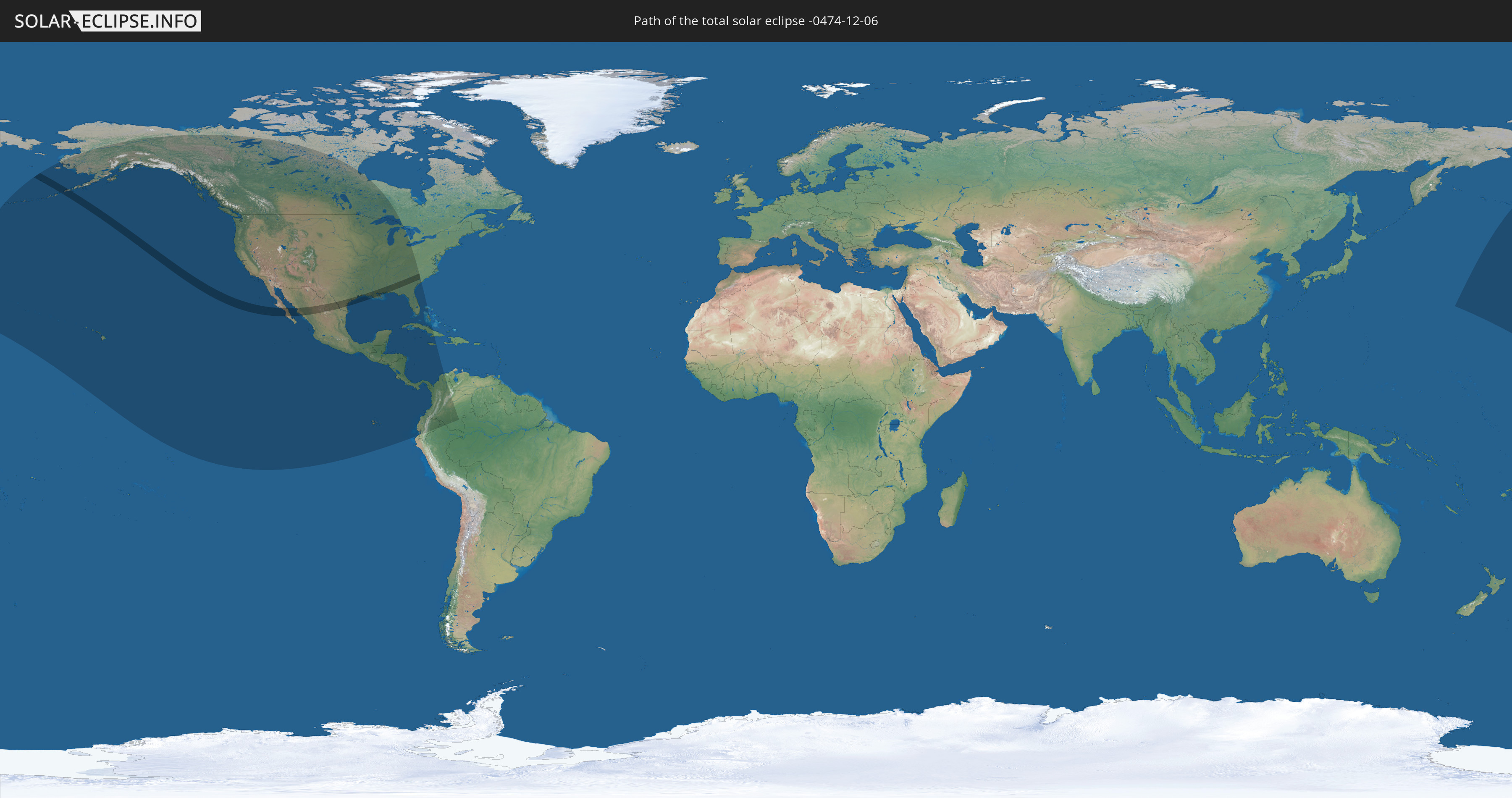
Die Sonnenfinsternis am 12/06/-0474 kann man in 19 Ländern als partielle Sonnenfinsternis beobachten.
Der Finsternispfad verläuft durch 2 Länder. Nur in diesen Ländern ist sie als total Sonnenfinsternis zu sehen.
In den folgenden Ländern ist die Sonnenfinsternis total zu sehen
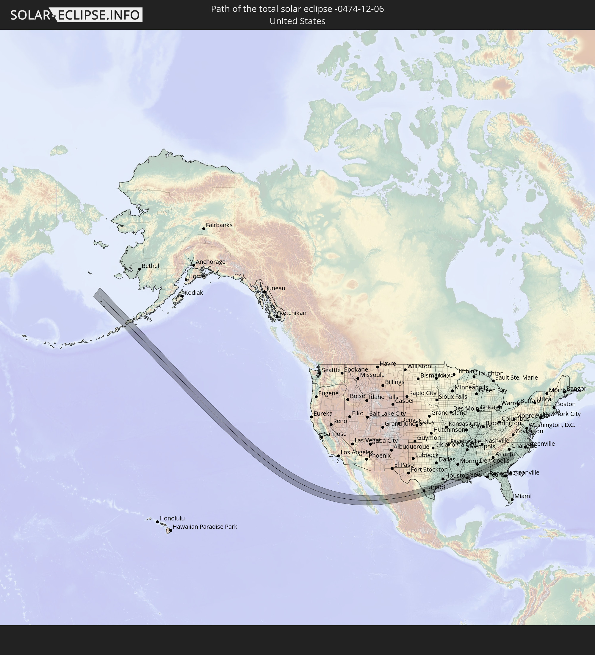 United States
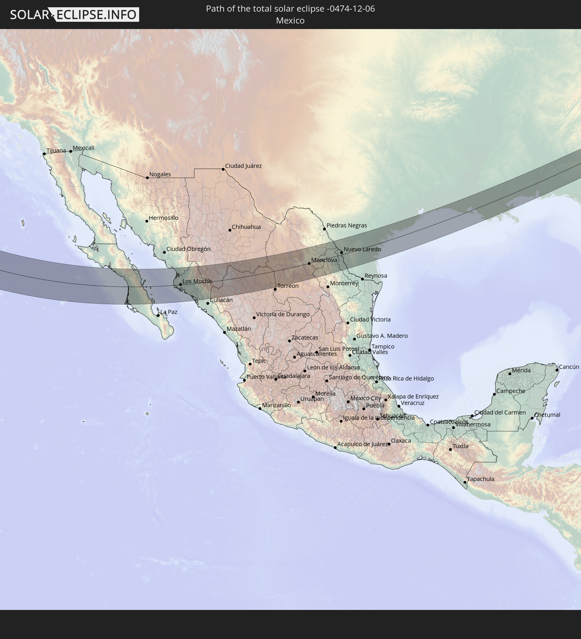 Mexico
In den folgenden Ländern ist die Sonnenfinsternis partiell zu sehen


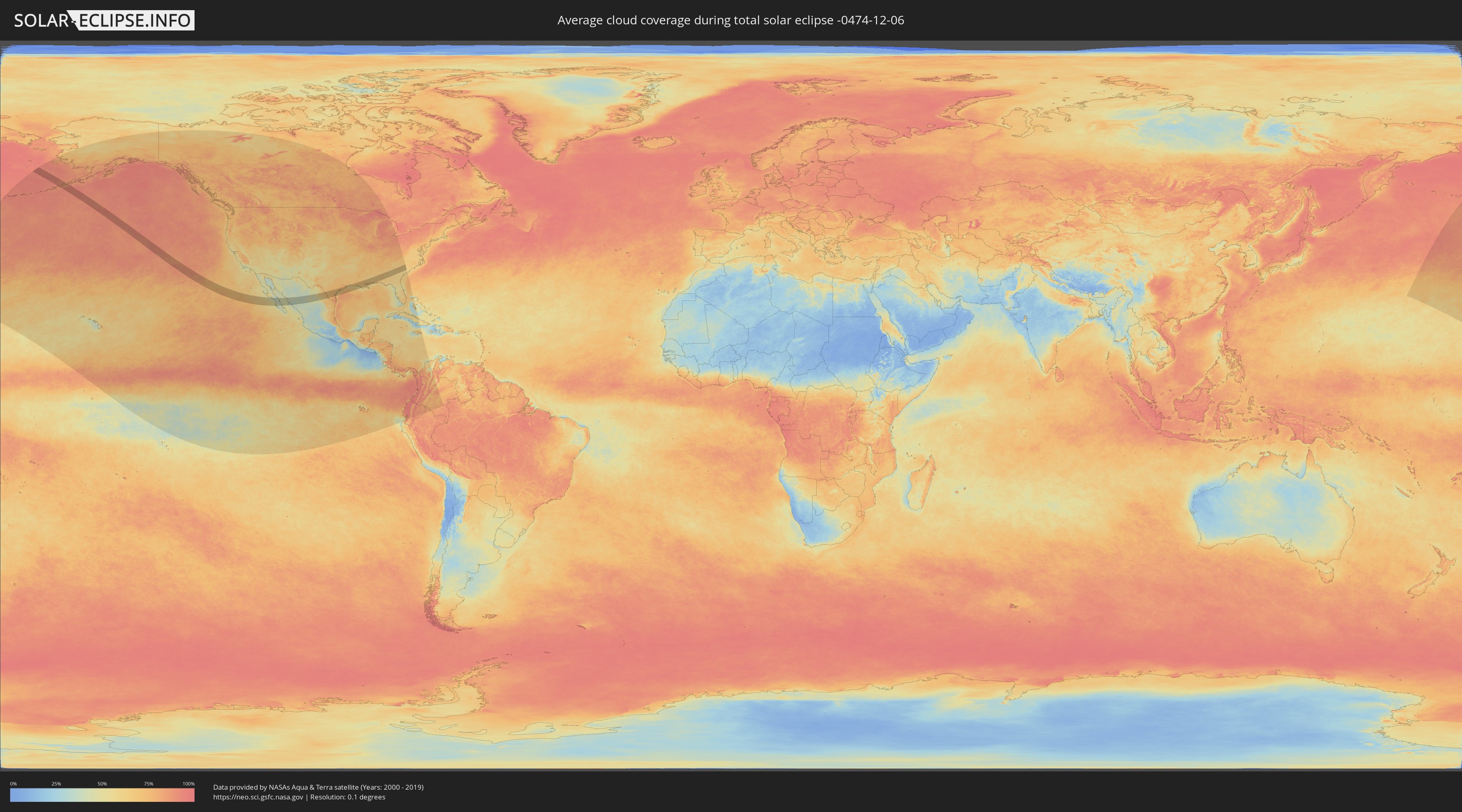
How will be the weather during the total solar eclipse on 12/06/-0474?
Where is the best place to see the total solar eclipse of 12/06/-0474?
The following maps show the average cloud coverage for the day of the total solar eclipse.
With the help of these maps, it is possible to find the place along the eclipse path, which has the best
chance of a cloudless sky.
Nevertheless, you should consider local circumstances and inform about the weather of your chosen
observation site.
The data is provided by NASAs satellites
AQUA and TERRA.
The cloud maps are averaged over a period of 19 years (2000 - 2019).

Detailed country maps
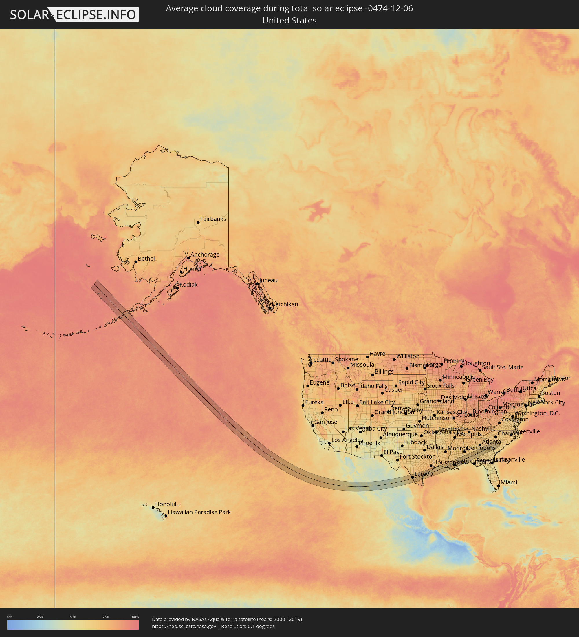 United States
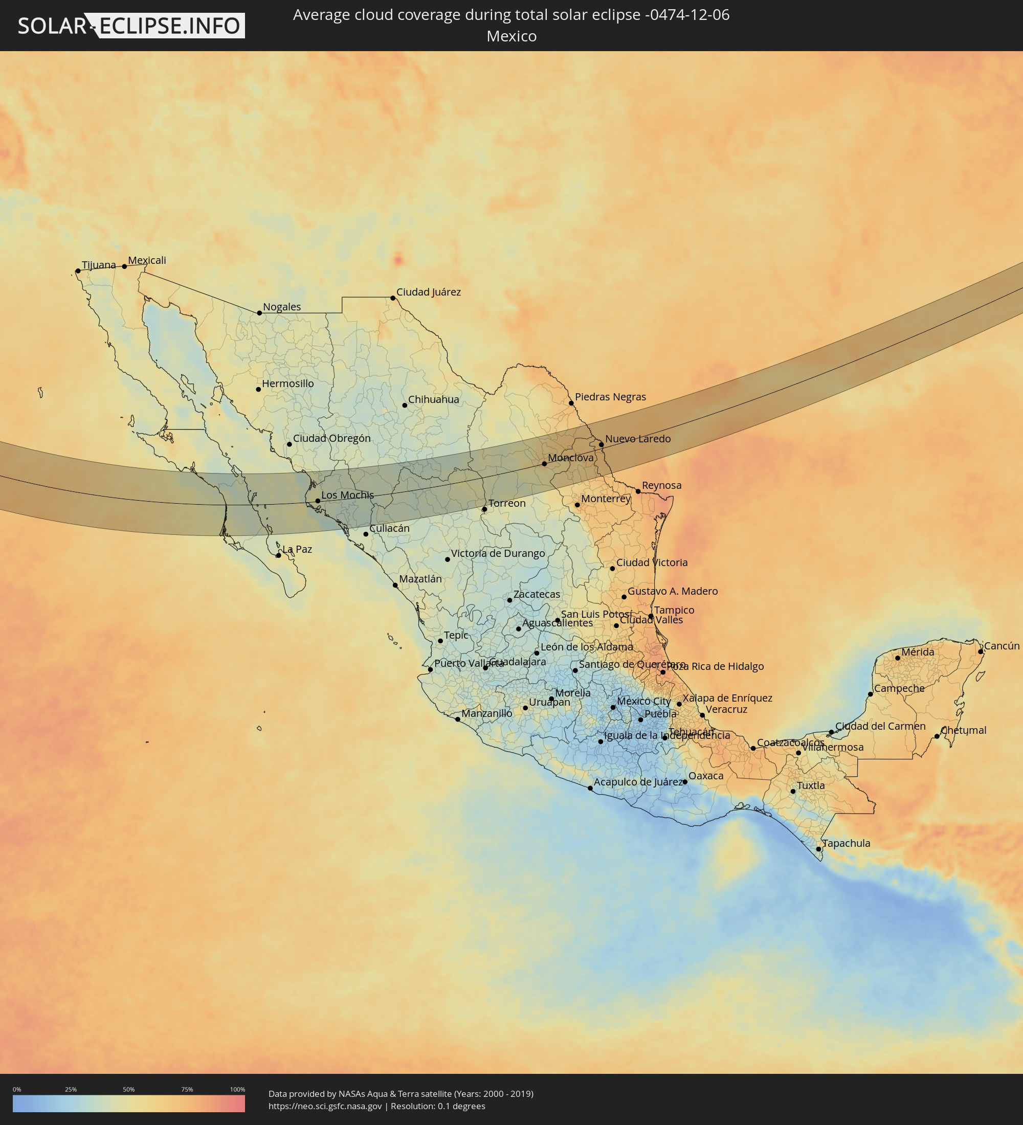 Mexico
Cities inside the path of the eclipse
The following table shows all locations with a population of more than 5,000 inside the eclipse path. Cities which have more than 100,000 inhabitants are marked bold. A click at the locations opens a detailed map.
| City | Type | Eclipse duration | Local time of max. eclipse | Distance to central line | Ø Cloud coverage |
 Ciudad Insurgentes, Baja California Sur
|
total | - | 14:35:49 UTC-07:05 | 48 km | 43% |
|
Ciudad Constitución, Baja California Sur
|
total | - | 14:36:19 UTC-07:05 | 74 km | 45% |
|
Loreto, Baja California Sur
|
total | - | 14:35:52 UTC-07:05 | 35 km | 39% |
|
Higuera de Zaragoza, Sinaloa
|
total | - | 14:40:03 UTC-07:05 | 21 km | 47% |
|
Ahome, Sinaloa
|
total | - | 14:40:22 UTC-07:05 | 15 km | 48% |
|
Topolobampo, Sinaloa
|
total | - | 14:40:58 UTC-07:05 | 21 km | 36% |
|
San Miguel Zapotitlan, Sinaloa
|
total | - | 14:40:34 UTC-07:05 | 17 km | 47% |
|
Los Mochis, Sinaloa
|
total | - | 14:40:51 UTC-07:05 | 0 km | 45% |
|
Juan Jose Rios, Sinaloa
|
total | - | 14:41:14 UTC-07:05 | 6 km | 40% |
|
San Blas, Sinaloa
|
total | - | 14:40:59 UTC-07:05 | 29 km | 41% |
|
Adolfo Ruíz Cortínes, Sinaloa
|
total | - | 14:41:23 UTC-07:05 | 7 km | 40% |
|
Leyva Solano, Sinaloa
|
total | - | 14:41:42 UTC-07:05 | 18 km | 39% |
|
El Fuerte de Montes Claros, Sinaloa
|
total | - | 14:40:52 UTC-07:05 | 66 km | 41% |
|
Guasave, Sinaloa
|
total | - | 14:42:08 UTC-07:05 | 30 km | 40% |
|
Choix, Sinaloa
|
total | - | 14:41:05 UTC-07:05 | 95 km | 39% |
|
Guamúchil, Sinaloa
|
total | - | 14:43:01 UTC-07:05 | 46 km | 38% |
|
La Reforma, Sinaloa
|
total | - | 14:43:29 UTC-07:05 | 88 km | 38% |
|
Mocorito, Sinaloa
|
total | - | 14:43:17 UTC-07:05 | 45 km | 36% |
|
Santa Bárbara, Chihuahua
|
total | - | 14:45:37 UTC-07:05 | 74 km | 38% |
|
Hidalgo del Parral, Chihuahua
|
total | - | 14:45:45 UTC-07:05 | 85 km | 38% |
|
Santa María del Oro, Durango
|
total | - | 15:16:29 UTC-06:36 | 28 km | 42% |
|
Bermejillo, Durango
|
total | - | 15:19:32 UTC-06:36 | 66 km | 47% |
|
Poanas, Durango
|
total | - | 15:19:42 UTC-06:36 | 79 km | 46% |
|
Tlahualilo de Zaragoza, Durango
|
total | - | 15:19:35 UTC-06:36 | 46 km | 43% |
|
Concordia, Coahuila
|
total | - | 15:20:30 UTC-06:36 | 88 km | 43% |
|
San Buenaventura, Coahuila
|
total | - | 15:21:29 UTC-06:36 | 17 km | 64% |
|
Ciudad Frontera, Coahuila
|
total | - | 15:21:48 UTC-06:36 | 0 km | 57% |
|
Castaños, Coahuila
|
total | - | 15:22:00 UTC-06:36 | 16 km | 55% |
|
Monclova, Coahuila
|
total | - | 15:21:52 UTC-06:36 | 3 km | 56% |
|
Minas de Barroterán, Coahuila
|
total | - | 15:21:12 UTC-06:36 | 74 km | 60% |
|
Lampazos de Naranjo, Nuevo León
|
total | - | 15:23:07 UTC-06:36 | 13 km | 62% |
|
Sabinas Hidalgo, Nuevo León
|
total | - | 15:24:12 UTC-06:36 | 77 km | 62% |
|
Ciudad Anáhuac, Nuevo León
|
total | - | 15:23:25 UTC-06:36 | 1 km | 68% |
|
Anáhuac, Nuevo León
|
total | - | 15:23:25 UTC-06:36 | 1 km | 68% |
|
El Campanario y Oradel, Tamaulipas
|
total | - | 15:23:53 UTC-06:36 | 12 km | 72% |
|
Nuevo Laredo, Tamaulipas
|
total | - | 15:24:02 UTC-06:36 | 10 km | 72% |
 Laredo, Texas
|
total | - | 16:00:36 UTC-06:00 | 13 km | 72% |
|
Alice, Texas
|
total | - | 16:02:19 UTC-06:00 | 1 km | 73% |
|
Kingsville, Texas
|
total | - | 16:02:53 UTC-06:00 | 32 km | 72% |
|
Beeville, Texas
|
total | - | 16:01:58 UTC-06:00 | 58 km | 73% |
|
Robstown, Texas
|
total | - | 16:02:49 UTC-06:00 | 9 km | 70% |
|
Corpus Christi, Texas
|
total | - | 16:03:10 UTC-06:00 | 16 km | 71% |
|
Ingleside, Texas
|
total | - | 16:03:19 UTC-06:00 | 13 km | 69% |
|
Aransas Pass, Texas
|
total | - | 16:03:21 UTC-06:00 | 12 km | 66% |
|
Rockport, Texas
|
total | - | 16:03:21 UTC-06:00 | 3 km | 68% |
|
Victoria, Texas
|
total | - | 16:02:28 UTC-06:00 | 79 km | 72% |
|
Port Lavaca, Texas
|
total | - | 16:03:11 UTC-06:00 | 47 km | 72% |
|
Bay City, Texas
|
total | - | 16:03:34 UTC-06:00 | 65 km | 75% |
|
Lake Jackson, Texas
|
total | - | 16:04:10 UTC-06:00 | 54 km | 74% |
|
Angleton, Texas
|
total | - | 16:04:00 UTC-06:00 | 68 km | 75% |
|
La Marque, Texas
|
total | - | 16:04:19 UTC-06:00 | 74 km | 74% |
|
Galveston, Texas
|
total | - | 16:04:36 UTC-06:00 | 61 km | 67% |
|
Crowley, Louisiana
|
total | - | 16:06:12 UTC-06:00 | 73 km | 73% |
|
Abbeville, Louisiana
|
total | - | 16:06:45 UTC-06:00 | 40 km | 71% |
|
Scott, Louisiana
|
total | - | 16:06:28 UTC-06:00 | 66 km | 73% |
|
Lafayette, Louisiana
|
total | - | 16:06:34 UTC-06:00 | 62 km | 73% |
|
Youngsville, Louisiana
|
total | - | 16:06:45 UTC-06:00 | 48 km | 73% |
|
Broussard, Louisiana
|
total | - | 16:06:43 UTC-06:00 | 52 km | 73% |
|
Breaux Bridge, Louisiana
|
total | - | 16:06:38 UTC-06:00 | 63 km | 69% |
|
New Iberia, Louisiana
|
total | - | 16:07:03 UTC-06:00 | 32 km | 68% |
|
Morgan City, Louisiana
|
total | - | 16:08:03 UTC-06:00 | 22 km | 64% |
|
Zachary, Louisiana
|
total | - | 16:06:56 UTC-06:00 | 75 km | 72% |
|
Baton Rouge, Louisiana
|
total | - | 16:07:11 UTC-06:00 | 54 km | 75% |
|
Gardere, Louisiana
|
total | - | 16:07:19 UTC-06:00 | 43 km | 72% |
|
Merrydale, Louisiana
|
total | - | 16:07:10 UTC-06:00 | 58 km | 75% |
|
Oak Hills Place, Louisiana
|
total | - | 16:07:21 UTC-06:00 | 42 km | 73% |
|
Central, Louisiana
|
total | - | 16:07:10 UTC-06:00 | 60 km | 71% |
|
Prairieville, Louisiana
|
total | - | 16:07:33 UTC-06:00 | 32 km | 73% |
|
Denham Springs, Louisiana
|
total | - | 16:07:20 UTC-06:00 | 51 km | 72% |
|
Gonzales, Louisiana
|
total | - | 16:07:40 UTC-06:00 | 24 km | 70% |
|
Thibodaux, Louisiana
|
total | - | 16:08:19 UTC-06:00 | 26 km | 71% |
|
Houma, Louisiana
|
total | - | 16:08:40 UTC-06:00 | 50 km | 71% |
|
Raceland, Louisiana
|
total | - | 16:08:37 UTC-06:00 | 41 km | 70% |
|
Reserve, Louisiana
|
total | - | 16:08:16 UTC-06:00 | 9 km | 71% |
|
Laplace, Louisiana
|
total | - | 16:08:19 UTC-06:00 | 10 km | 71% |
|
Hammond, Louisiana
|
total | - | 16:07:48 UTC-06:00 | 34 km | 68% |
|
Saint Rose, Louisiana
|
total | - | 16:08:37 UTC-06:00 | 28 km | 68% |
|
Kenner, Louisiana
|
total | - | 16:08:38 UTC-06:00 | 26 km | 73% |
|
Waggaman, Louisiana
|
total | - | 16:08:46 UTC-06:00 | 35 km | 69% |
|
Harahan, Louisiana
|
total | - | 16:08:45 UTC-06:00 | 33 km | 69% |
|
Westwego, Louisiana
|
total | - | 16:08:51 UTC-06:00 | 39 km | 71% |
|
Covington, Louisiana
|
total | - | 16:08:11 UTC-06:00 | 18 km | 67% |
|
New Orleans, Louisiana
|
total | - | 16:08:51 UTC-06:00 | 36 km | 73% |
|
Mandeville, Louisiana
|
total | - | 16:08:22 UTC-06:00 | 5 km | 66% |
|
Timberlane, Louisiana
|
total | - | 16:08:59 UTC-06:00 | 46 km | 71% |
|
Lacombe, Louisiana
|
total | - | 16:08:32 UTC-06:00 | 4 km | 67% |
|
Bogalusa, Louisiana
|
total | - | 16:08:02 UTC-06:00 | 41 km | 70% |
|
Slidell, Louisiana
|
total | - | 16:08:44 UTC-06:00 | 14 km | 69% |
|
Carriere, Mississippi
|
total | - | 16:08:26 UTC-06:00 | 16 km | 71% |
|
Diamondhead, Mississippi
|
total | - | 16:08:58 UTC-06:00 | 18 km | 63% |
|
Bay Saint Louis, Mississippi
|
total | - | 16:09:07 UTC-06:00 | 28 km | 62% |
|
Hattiesburg, Mississippi
|
total | - | 16:07:53 UTC-06:00 | 75 km | 66% |
|
Petal, Mississippi
|
total | - | 16:07:53 UTC-06:00 | 76 km | 66% |
|
West Gulfport, Mississippi
|
total | - | 16:09:13 UTC-06:00 | 27 km | 66% |
|
D'Iberville, Mississippi
|
total | - | 16:09:22 UTC-06:00 | 32 km | 62% |
|
Biloxi, Mississippi
|
total | - | 16:09:24 UTC-06:00 | 35 km | 62% |
|
Pascagoula, Mississippi
|
total | - | 16:09:44 UTC-06:00 | 51 km | 65% |
|
Tillmans Corner, Alabama
|
total | - | 16:09:48 UTC-06:00 | 43 km | 70% |
|
Mobile, Alabama
|
total | - | 16:09:47 UTC-06:00 | 37 km | 65% |
|
Daphne, Alabama
|
total | - | 16:10:01 UTC-06:00 | 52 km | 65% |
|
Bay Minette, Alabama
|
total | - | 16:09:47 UTC-06:00 | 28 km | 64% |
|
Atmore, Alabama
|
total | - | 16:09:50 UTC-06:00 | 24 km | 66% |
|
Cantonment, Florida
|
total | - | 16:10:29 UTC-06:00 | 73 km | 68% |
|
Greenville, Alabama
|
total | - | 16:09:33 UTC-06:00 | 23 km | 66% |
|
Andalusia, Alabama
|
total | - | 16:10:19 UTC-06:00 | 35 km | 66% |
|
Montgomery, Alabama
|
total | - | 16:09:07 UTC-06:00 | 65 km | 69% |
|
Troy, Alabama
|
total | - | 16:10:05 UTC-06:00 | 4 km | 69% |
|
Enterprise, Alabama
|
total | - | 16:10:48 UTC-06:00 | 59 km | 68% |
|
Tuskegee, Alabama
|
total | - | 16:09:32 UTC-06:00 | 47 km | 67% |
|
Ozark, Alabama
|
total | - | 16:10:47 UTC-06:00 | 53 km | 64% |
|
Auburn, Alabama
|
total | - | 16:09:27 UTC-06:00 | 57 km | 68% |
|
Valley, Alabama
|
total | - | 16:09:24 UTC-06:00 | 66 km | 65% |
|
Eufaula, Alabama
|
total | - | 16:10:37 UTC-06:00 | 29 km | 61% |
|
Columbus, Georgia
|
total | - | 17:10:00 UTC-05:00 | 22 km | 66% |
|
Cusseta, Georgia
|
total | - | 17:10:22 UTC-05:00 | 2 km | 61% |
|
Thomaston, Georgia
|
total | - | 17:09:56 UTC-05:00 | 39 km | 62% |
|
Americus, Georgia
|
total | - | 17:11:03 UTC-05:00 | 47 km | 63% |
|
Fort Valley, Georgia
|
total | - | 17:10:40 UTC-05:00 | 13 km | 63% |
|
Perry, Georgia
|
total | - | 17:10:54 UTC-05:00 | 29 km | 62% |
|
Macon, Georgia
|
total | - | 17:10:29 UTC-05:00 | 6 km | 60% |
|
Warner Robins, Georgia
|
total | - | 17:10:47 UTC-05:00 | 17 km | 63% |
|
Milledgeville, Georgia
|
total | - | 17:10:27 UTC-05:00 | 13 km | 61% |
|
Dublin, Georgia
|
total | - | 17:11:21 UTC-05:00 | 54 km | 64% |
|
Evans, Georgia
|
total | - | 17:10:35 UTC-05:00 | 14 km | 65% |
|
Augusta, Georgia
|
total | - | 17:10:45 UTC-05:00 | 1 km | 63% |
|
Aiken, South Carolina
|
total | - | 17:10:48 UTC-05:00 | 1 km | 63% |
|
Newberry, South Carolina
|
total | - | 17:09:56 UTC-05:00 | 66 km | 65% |
|
Red Bank, South Carolina
|
total | - | 17:10:36 UTC-05:00 | 16 km | 66% |
|
Lexington, South Carolina
|
total | - | 17:10:33 UTC-05:00 | 21 km | 66% |
|
Oak Grove, South Carolina
|
total | - | 17:10:36 UTC-05:00 | 17 km | 66% |
|
Columbia, South Carolina
|
total | - | 17:10:38 UTC-05:00 | 14 km | 65% |
|
Forest Acres, South Carolina
|
total | - | 17:10:38 UTC-05:00 | 14 km | 65% |
|
Oak Grove, South Carolina
|
total | - | 17:10:58 UTC-05:00 | 10 km | 63% |
|
Woodfield, South Carolina
|
total | - | 17:10:37 UTC-05:00 | 16 km | 64% |
|
Orangeburg, South Carolina
|
total | - | 17:11:24 UTC-05:00 | 44 km | 63% |
|
Sumter, South Carolina
|
total | - | 17:11:08 UTC-05:00 | 22 km | 64% |