Total solar eclipse of 07/22/-0494
| Day of week: | Saturday |
| Maximum duration of eclipse: | 06m11s |
| Maximum width of eclipse path: | 220 km |
| Saros cycle: | 57 |
| Coverage: | 100% |
| Magnitude: | 1.0674 |
| Gamma: | -0.0322 |
Wo kann man die Sonnenfinsternis vom 07/22/-0494 sehen?
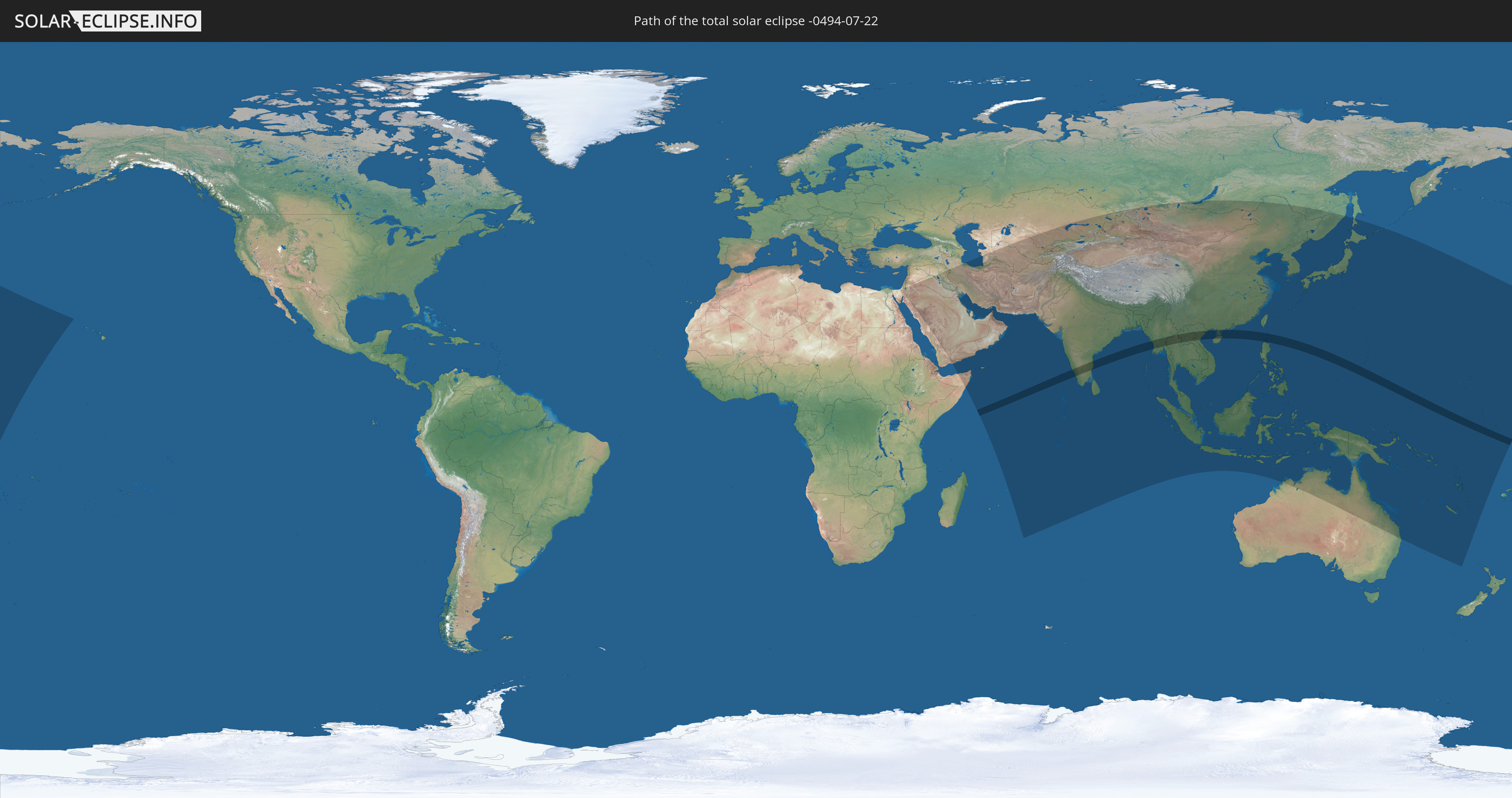
Die Sonnenfinsternis am 07/22/-0494 kann man in 65 Ländern als partielle Sonnenfinsternis beobachten.
Der Finsternispfad verläuft durch 11 Länder. Nur in diesen Ländern ist sie als total Sonnenfinsternis zu sehen.
In den folgenden Ländern ist die Sonnenfinsternis total zu sehen
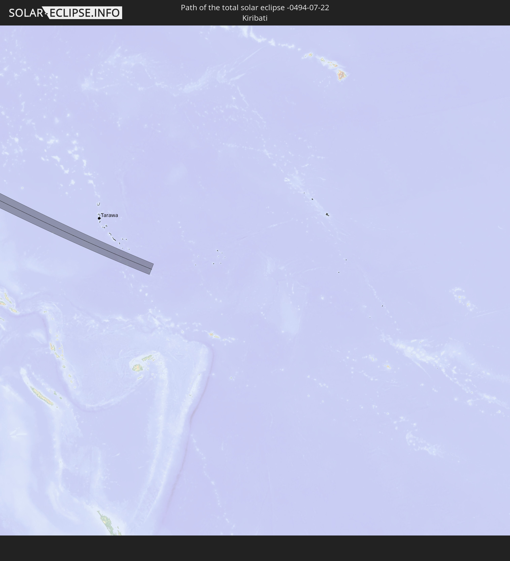 Kiribati
 India
India
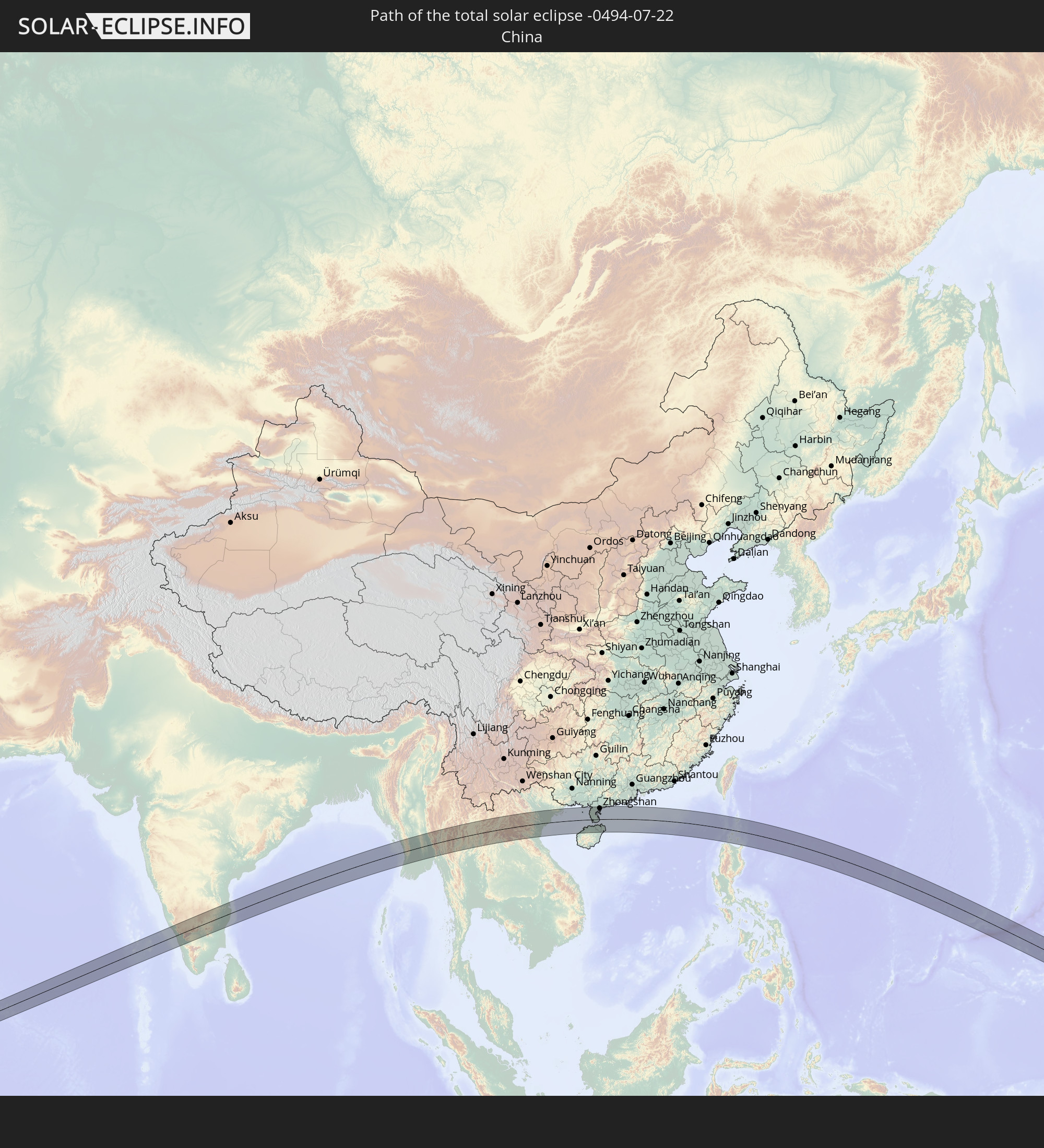 China
China
 Myanmar
 Thailand
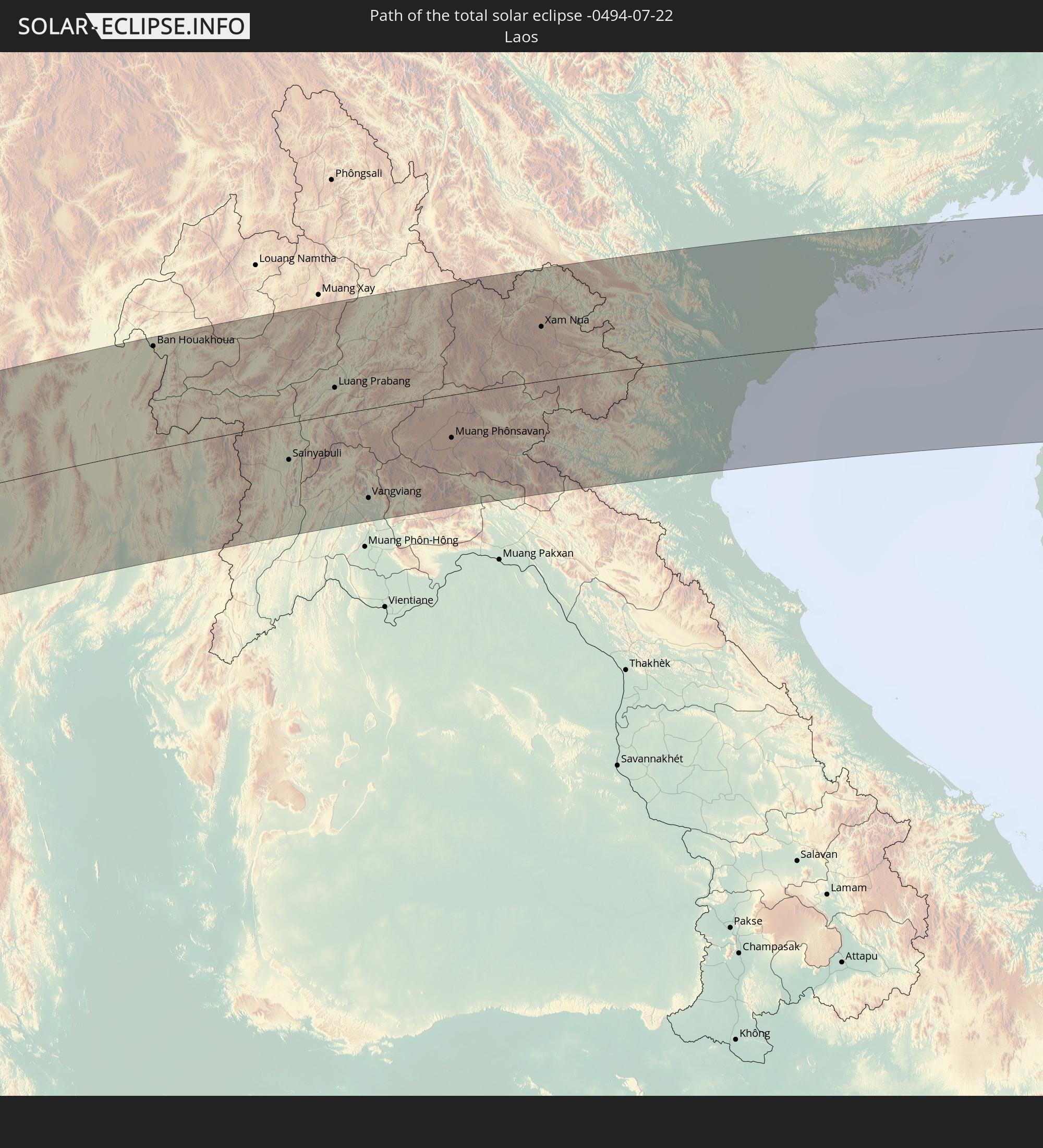 Laos
Laos
 Vietnam
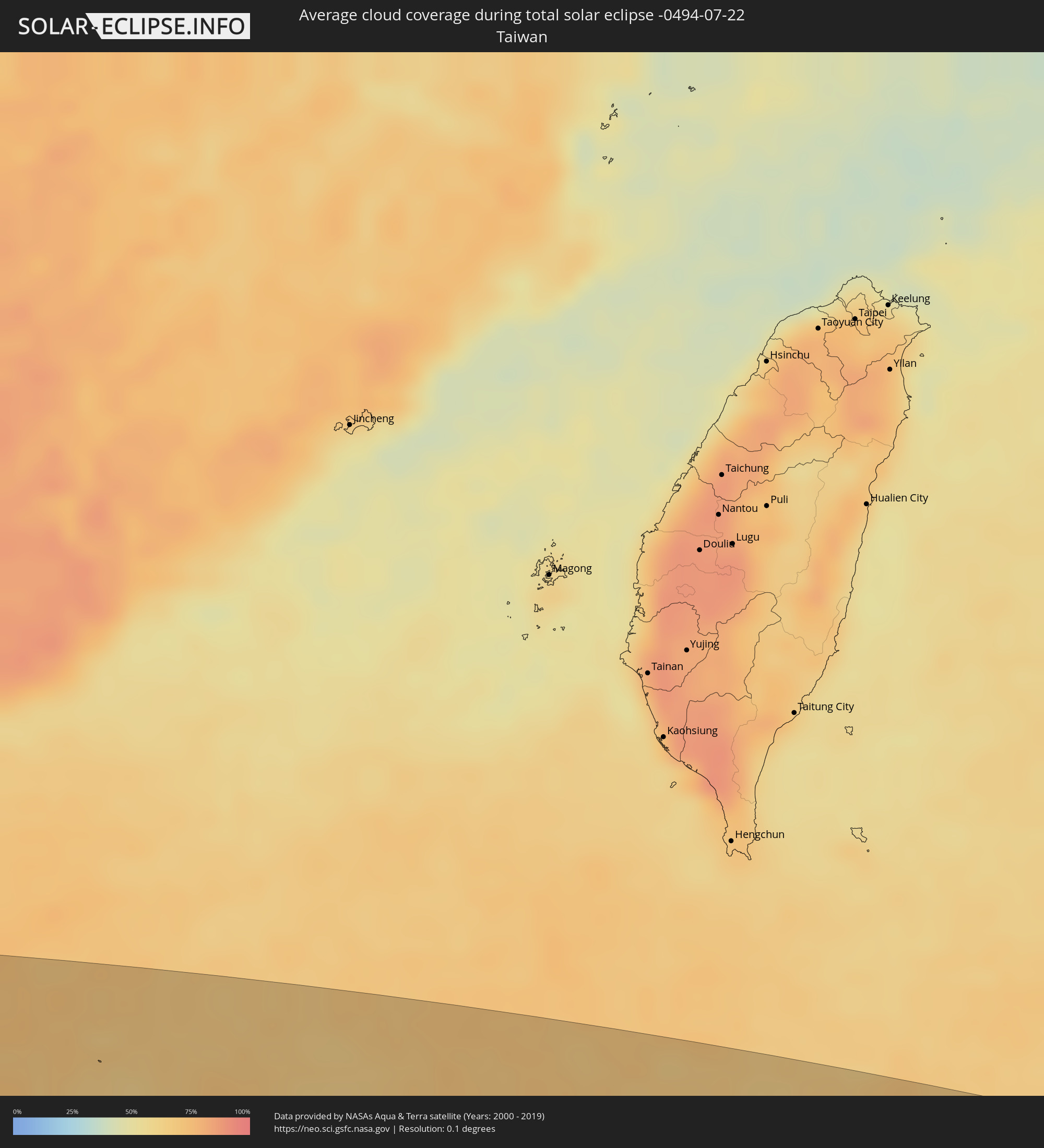
 Taiwan
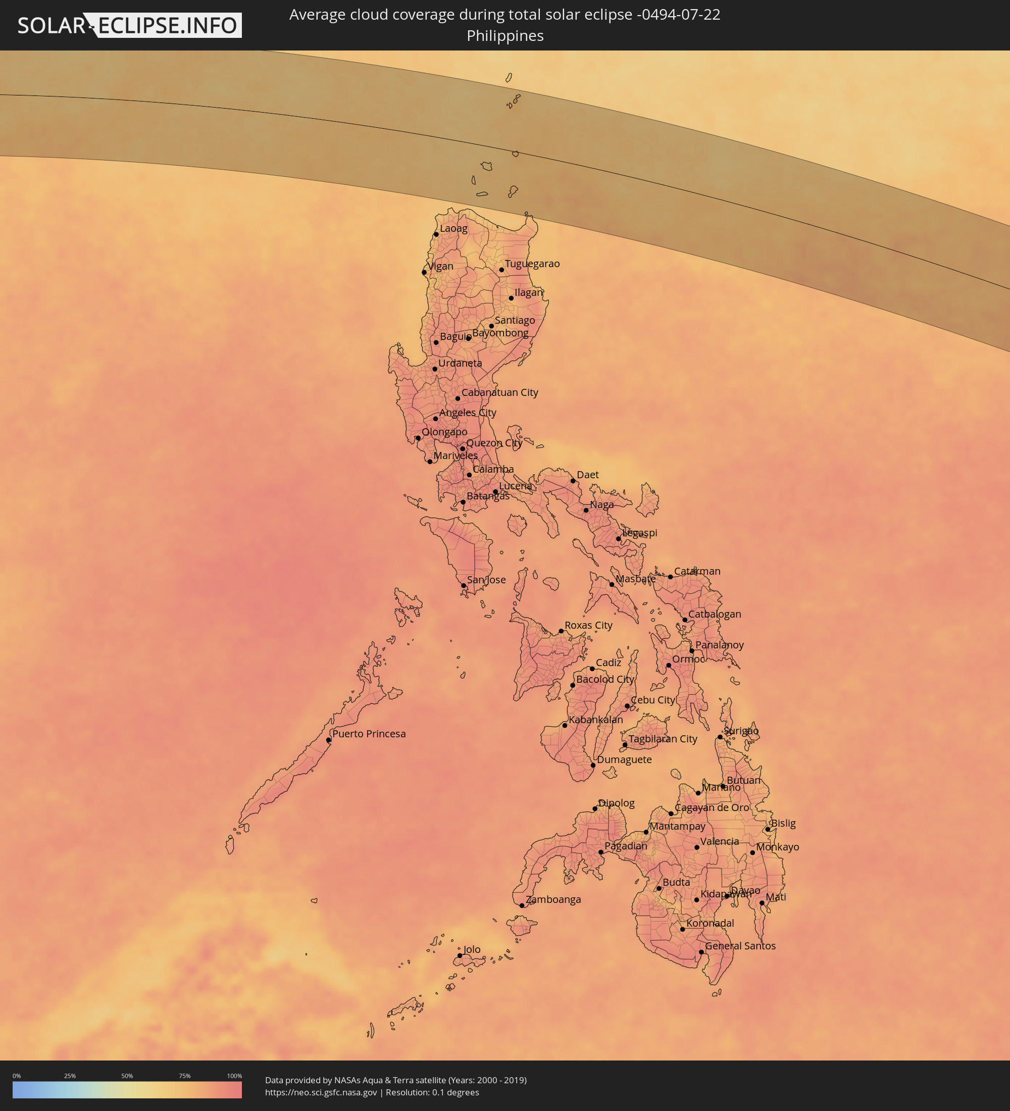
 Philippines
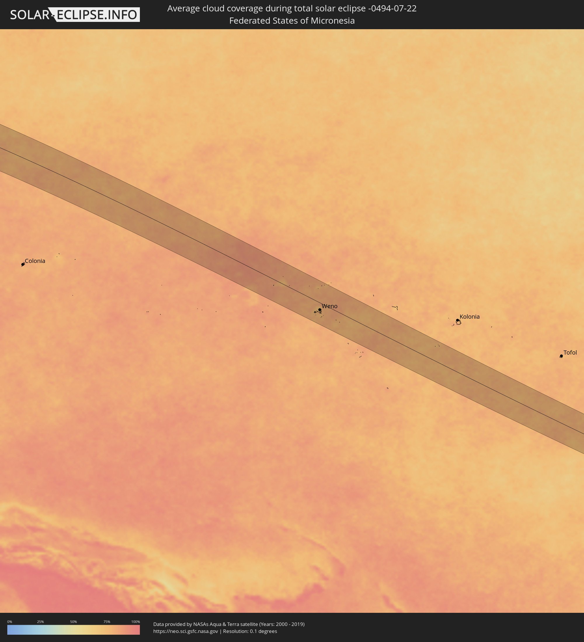
 Federated States of Micronesia
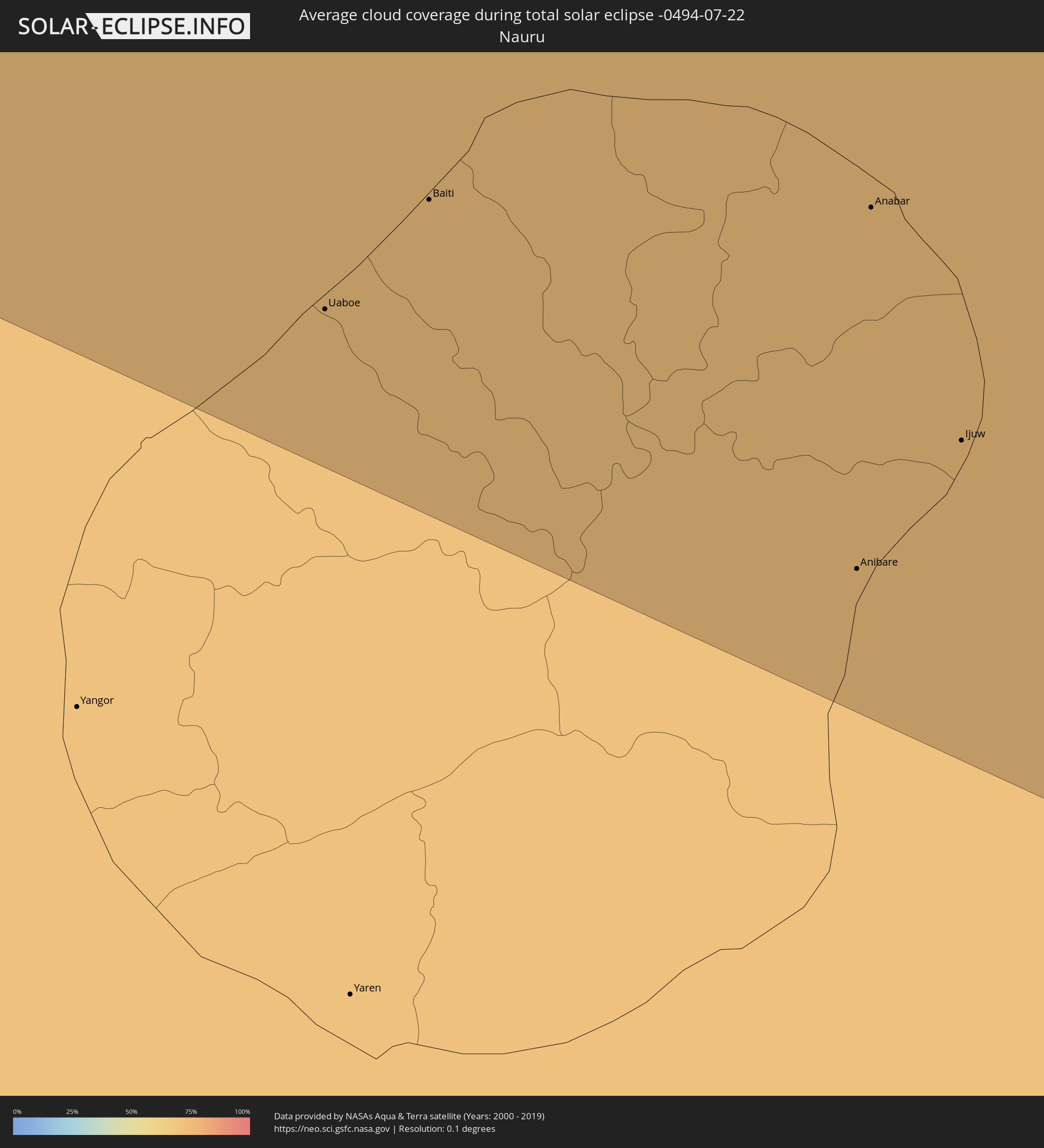
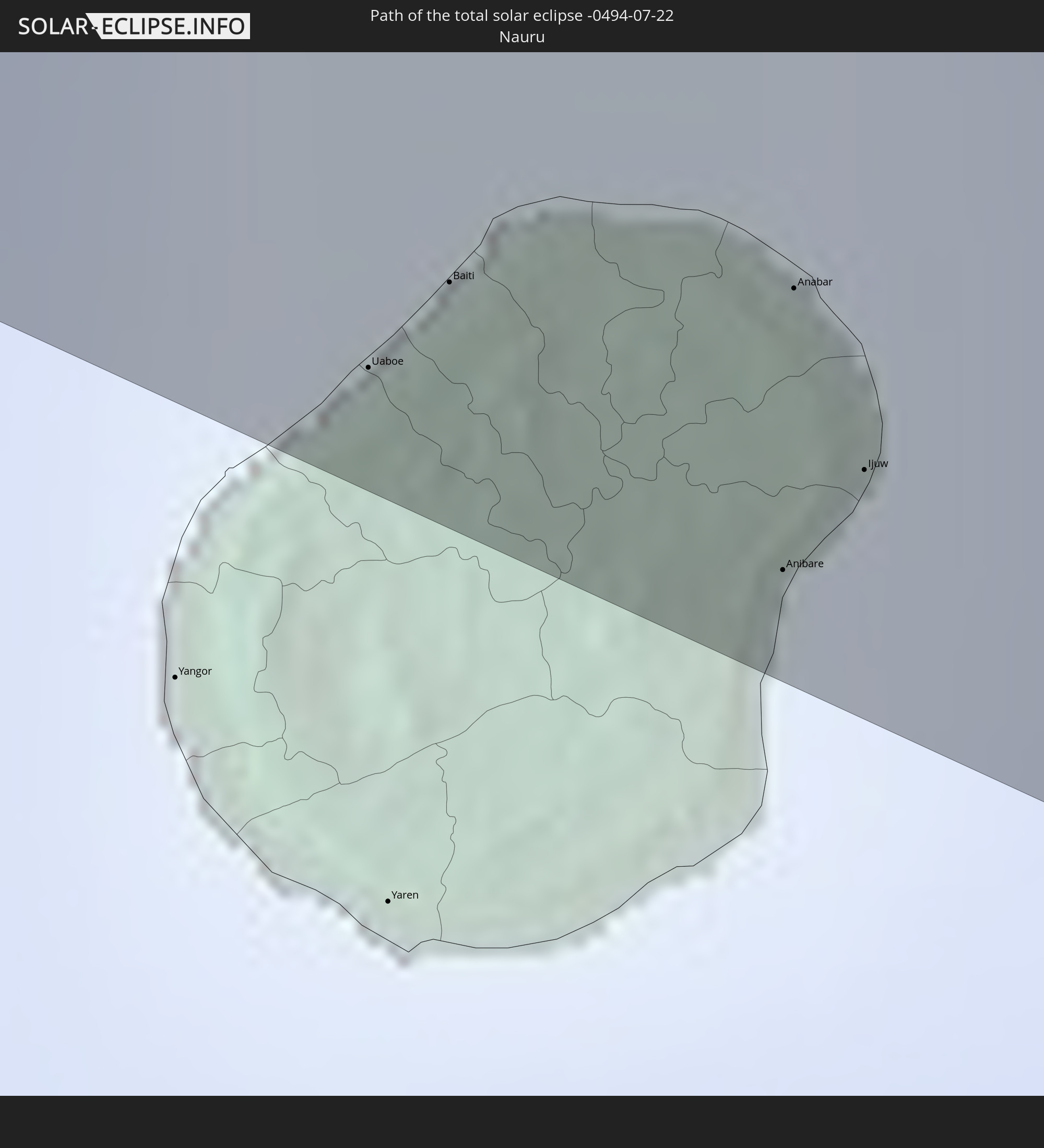 Nauru
Nauru
In den folgenden Ländern ist die Sonnenfinsternis partiell zu sehen
 Russia
 United States Minor Outlying Islands
 Kiribati
 Israel
 Saudi Arabia
 Jordan
 Iraq
Iraq
 Somalia
 Yemen
Yemen
 Iran
Iran
 Seychelles
 Kazakhstan
 Kuwait
 Bahrain
 Qatar
Qatar
 United Arab Emirates
 Oman
Oman
 Turkmenistan
 Uzbekistan
 Mauritius
 Afghanistan
 Pakistan
 Tajikistan
 India
India
 Kyrgyzstan
 British Indian Ocean Territory
 Maldives
 China
China
 Sri Lanka
 Nepal
Nepal
 Mongolia
 Bangladesh
 Bhutan
 Myanmar
 Indonesia
 Cocos Islands
 Thailand
 Malaysia
 Laos
Laos
 Vietnam
 Cambodia
 Singapore
 Christmas Island
 Australia
 Macau
Macau
 Hong Kong
 Brunei
 Taiwan
 Philippines
 Japan
Japan
 East Timor
 North Korea
 South Korea
 Palau
Palau
 Federated States of Micronesia
 Papua New Guinea
 Guam
Guam
 Northern Mariana Islands
 Solomon Islands
 New Caledonia
 Marshall Islands
 Vanuatu
 Nauru
Nauru
 Norfolk Island
 Tuvalu
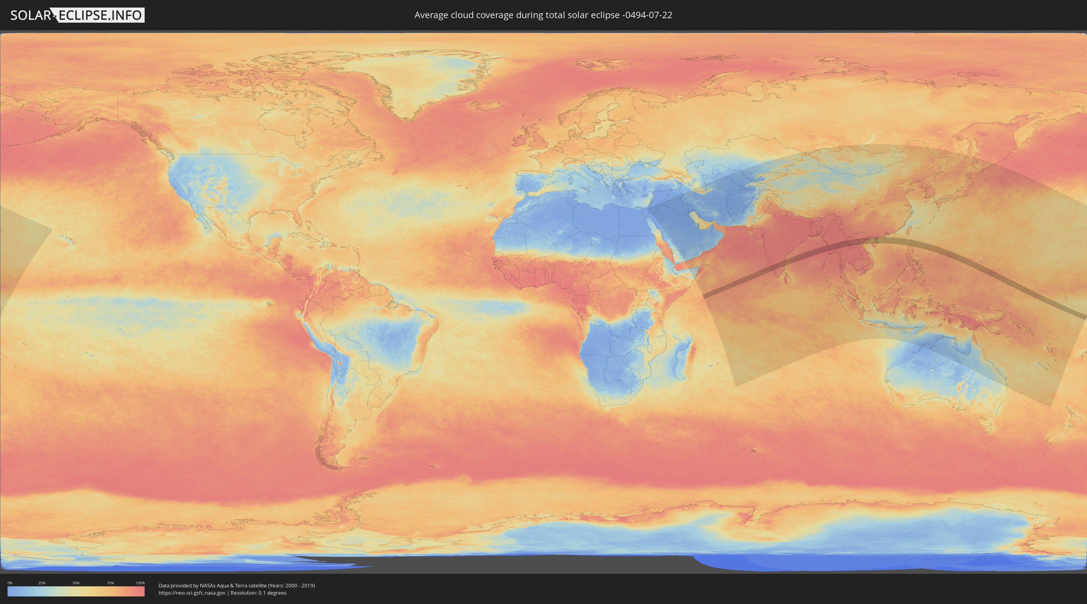
How will be the weather during the total solar eclipse on 07/22/-0494?
Where is the best place to see the total solar eclipse of 07/22/-0494?
The following maps show the average cloud coverage for the day of the total solar eclipse.
With the help of these maps, it is possible to find the place along the eclipse path, which has the best
chance of a cloudless sky.
Nevertheless, you should consider local circumstances and inform about the weather of your chosen
observation site.
The data is provided by NASAs satellites
AQUA and TERRA.
The cloud maps are averaged over a period of 19 years (2000 - 2019).

Detailed country maps
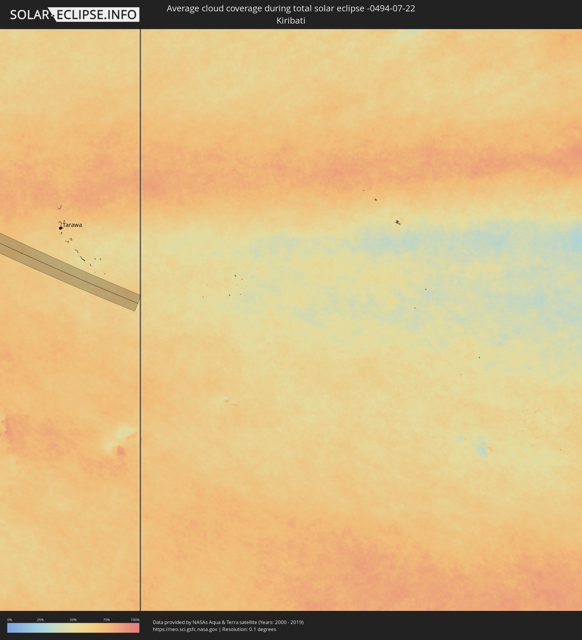 Kiribati
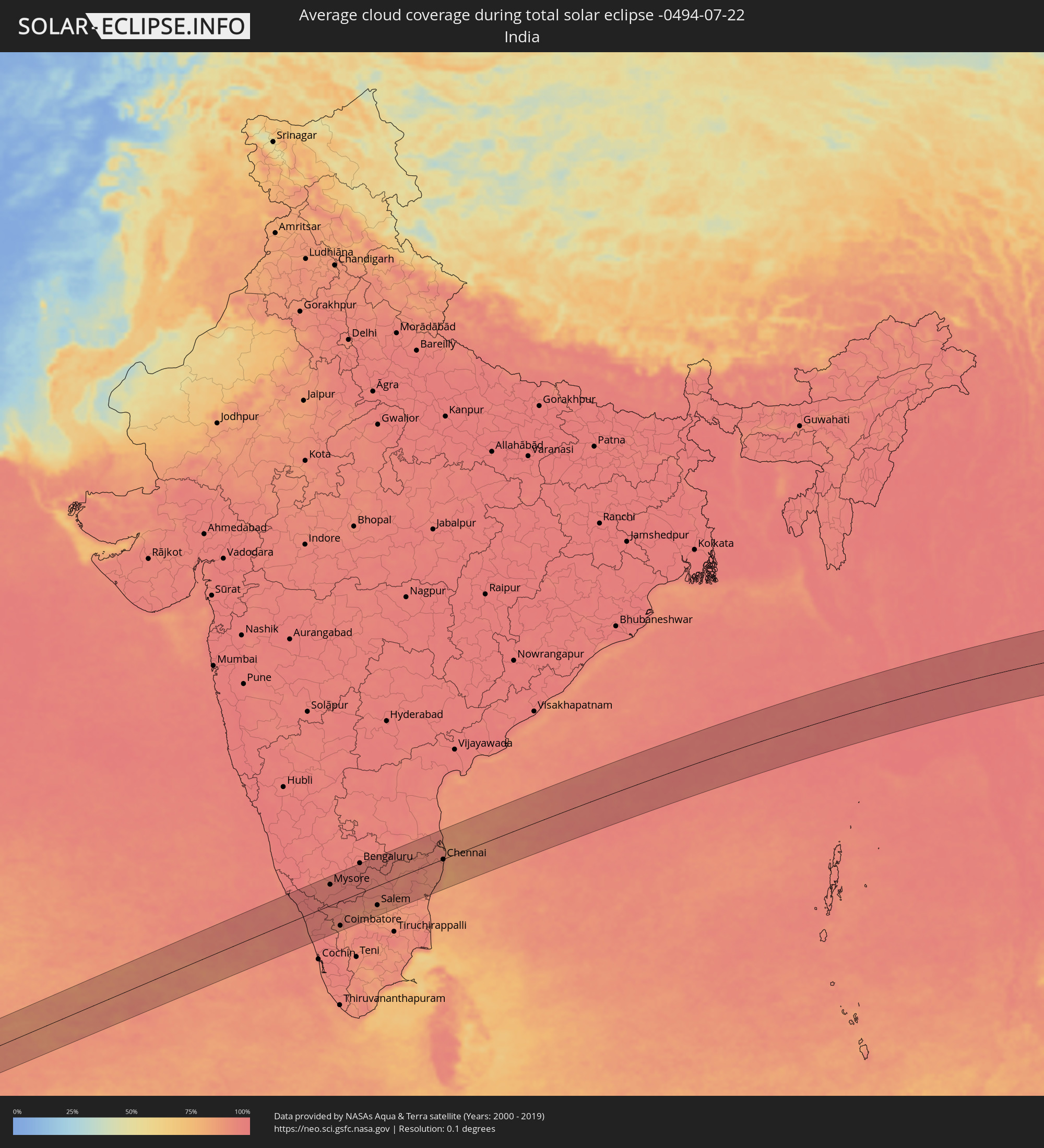 India
India
 China
China
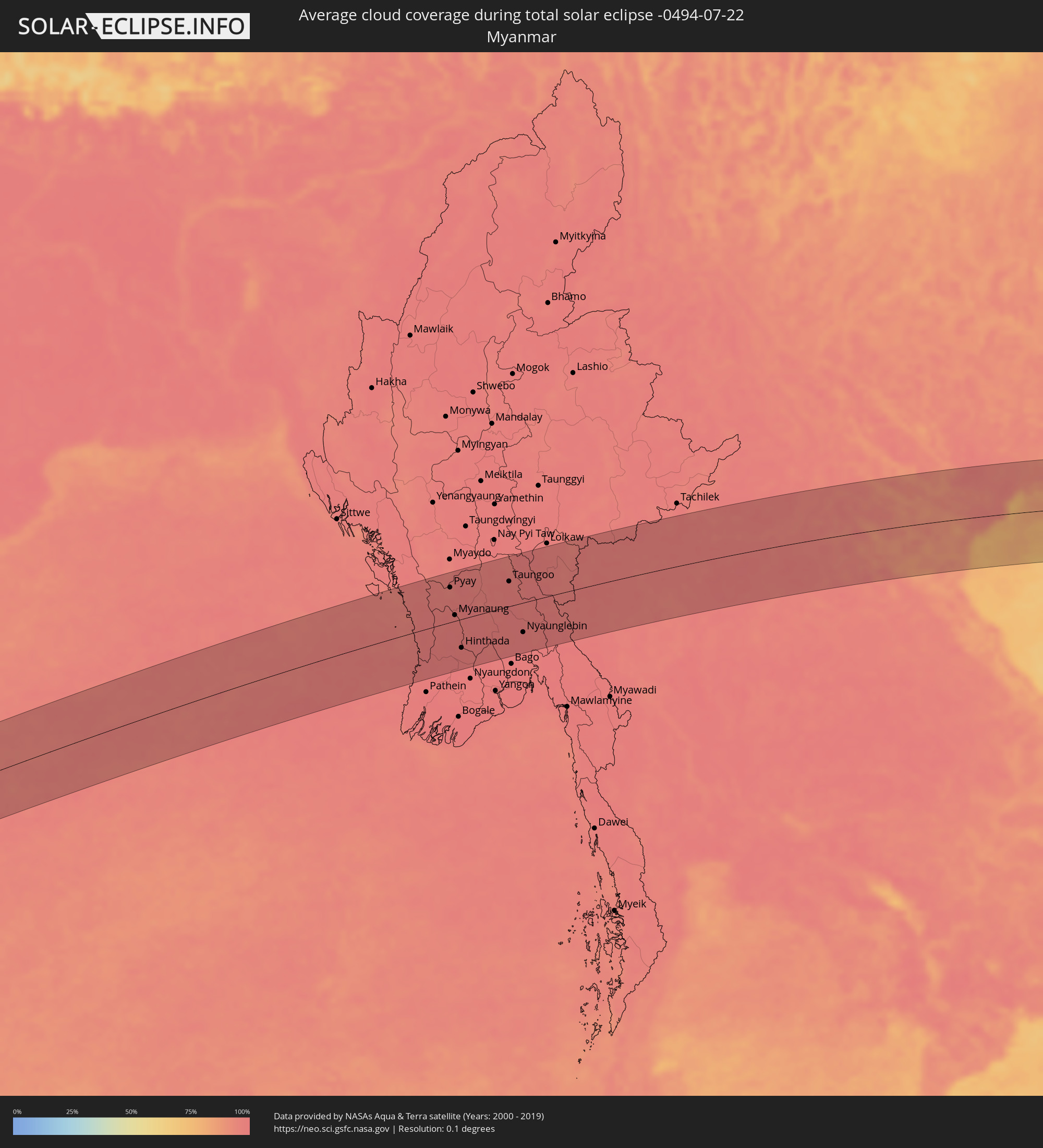 Myanmar
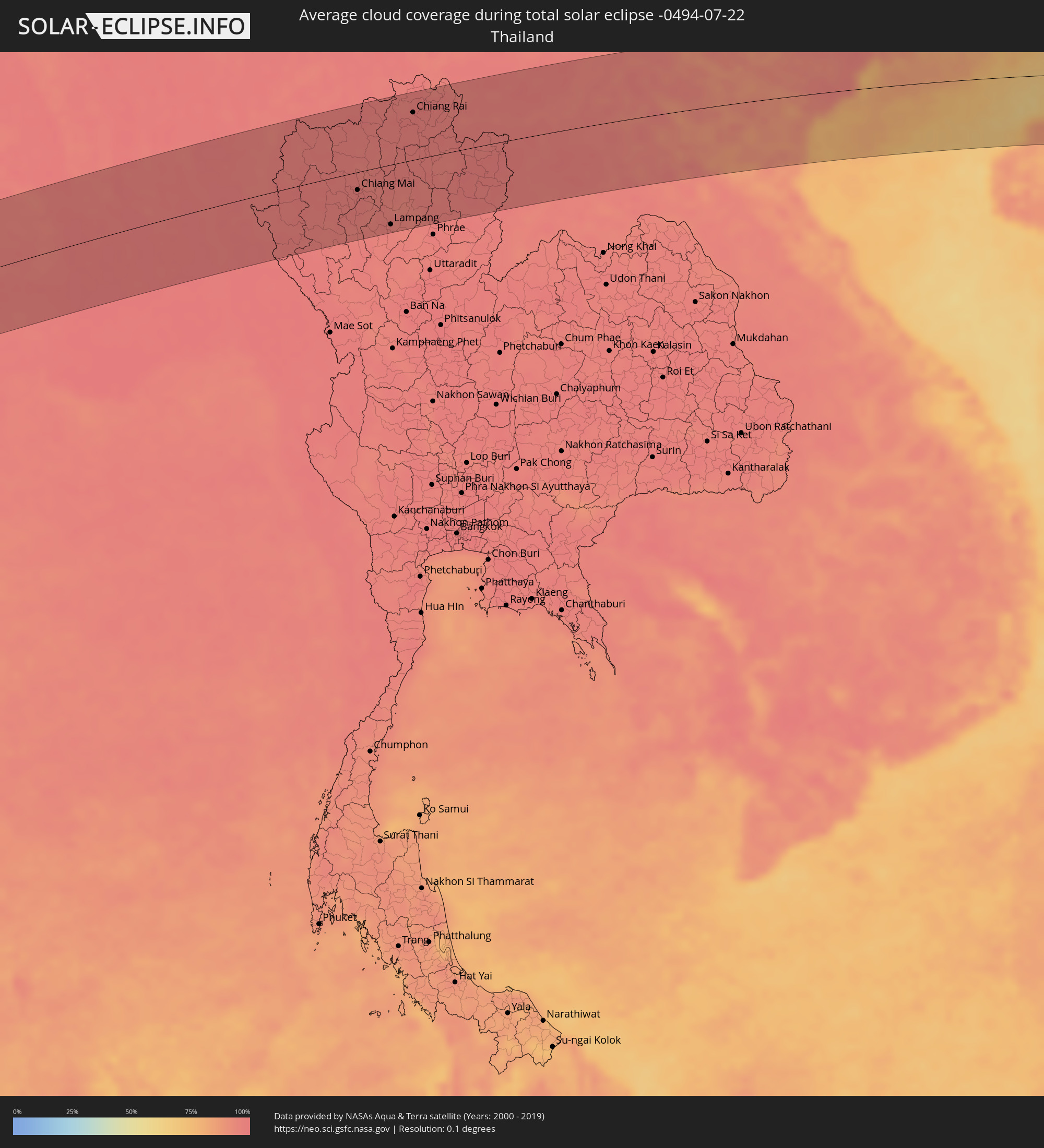 Thailand
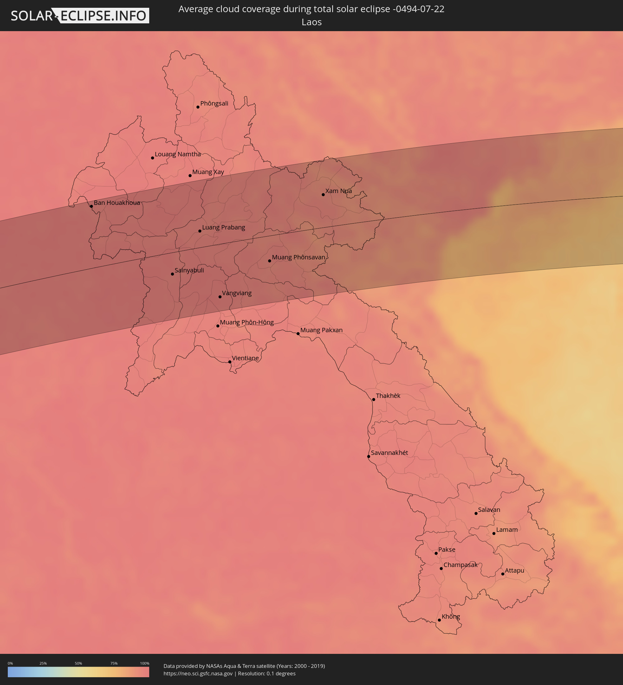 Laos
Laos
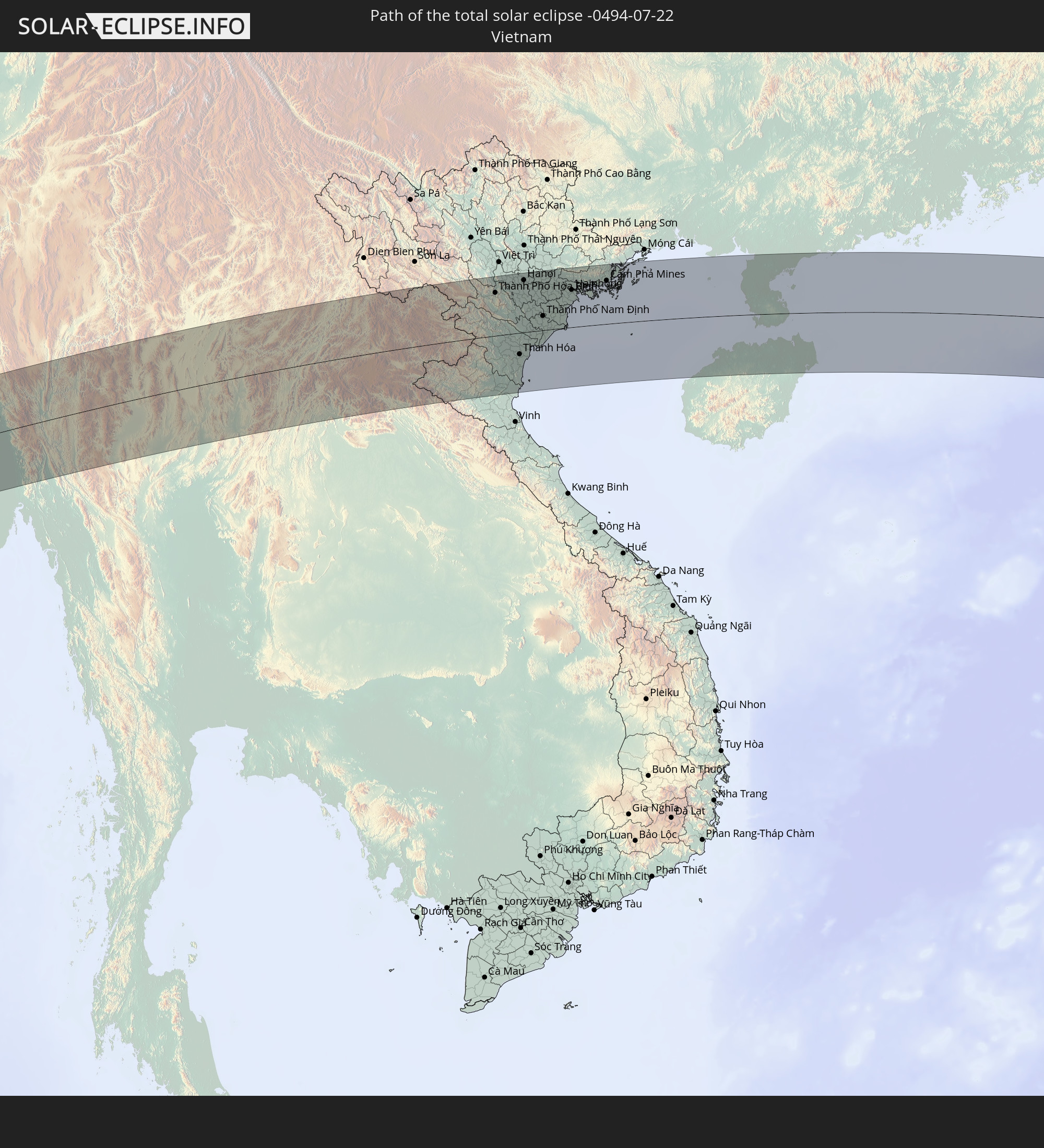
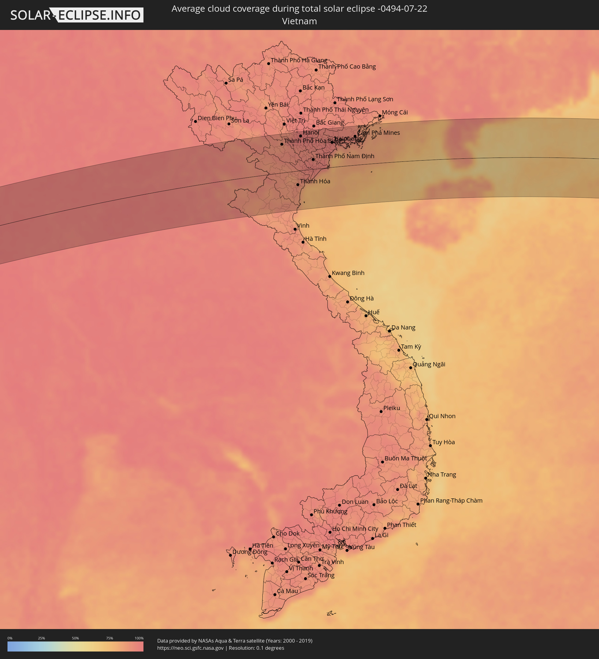 Vietnam
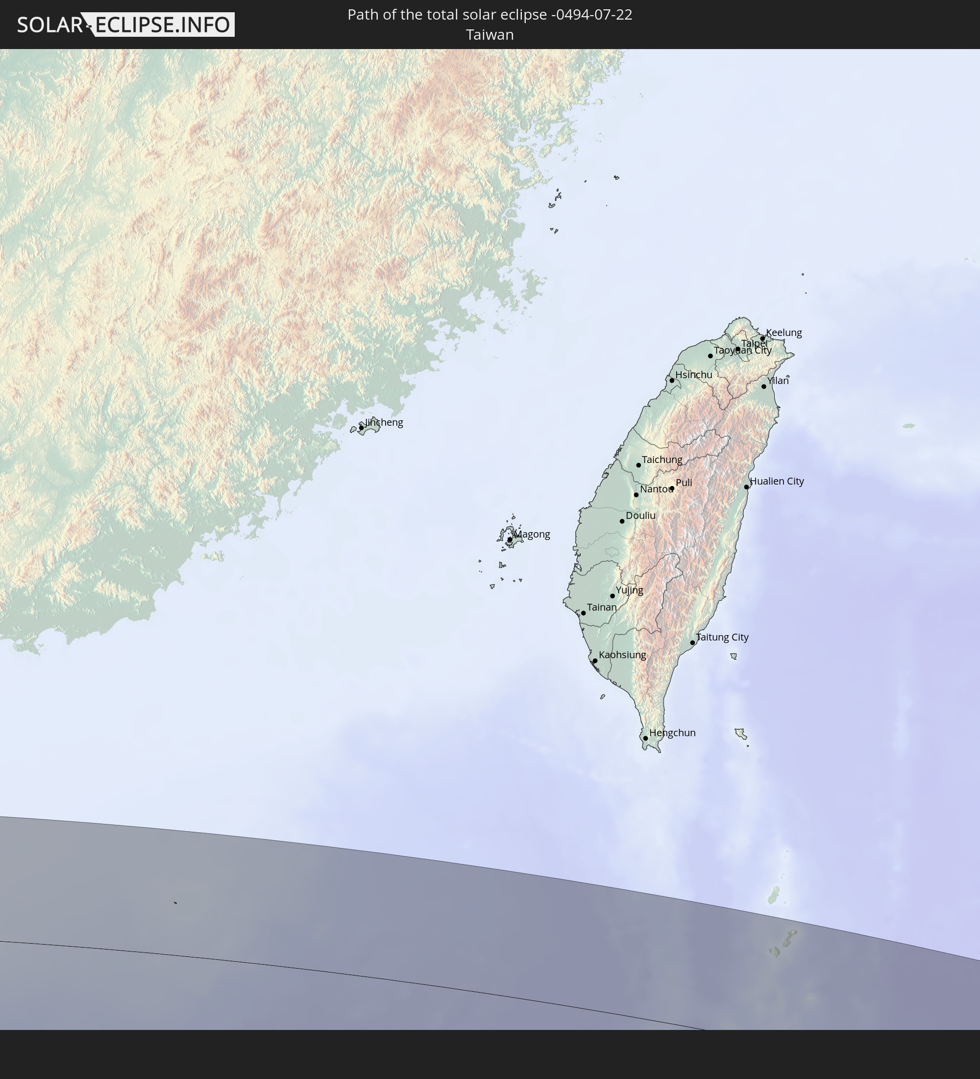
 Taiwan
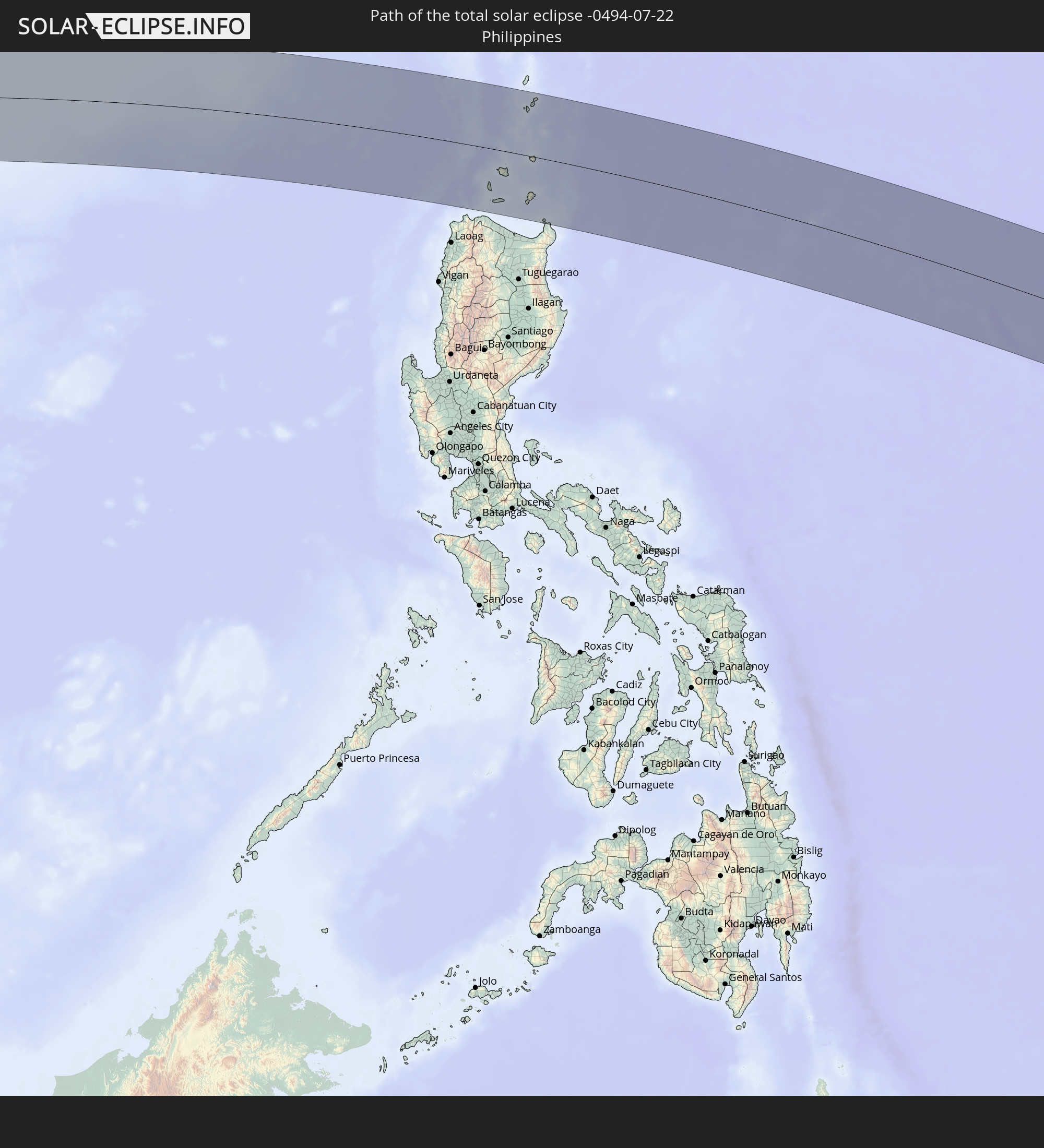
 Philippines
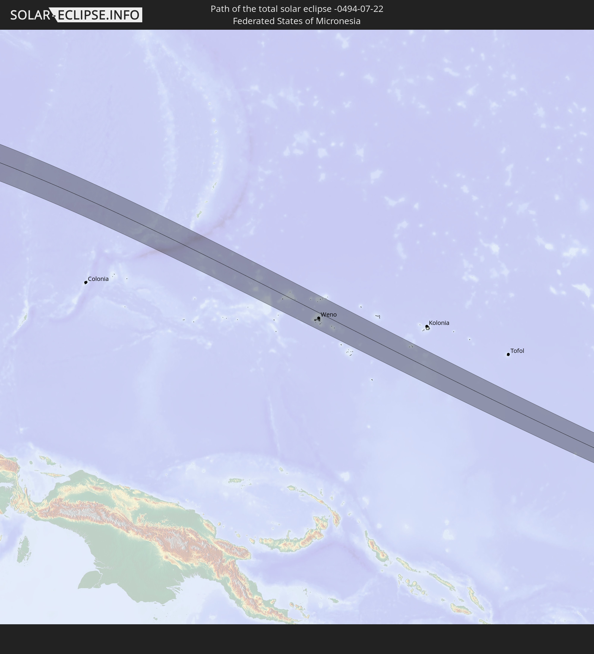
 Federated States of Micronesia
 Nauru
Nauru
Cities inside the path of the eclipse
The following table shows all locations with a population of more than 5,000 inside the eclipse path. Cities which have more than 100,000 inhabitants are marked bold. A click at the locations opens a detailed map.
| City | Type | Eclipse duration | Local time of max. eclipse | Distance to central line | Ø Cloud coverage |
|
Tellicherry, Kerala
|
total | - | 07:59:39 UTC+05:21 | 58 km | 94% |
|
Kozhikode, Kerala
|
total | - | 07:59:35 UTC+05:21 | 5 km | 94% |
|
Ponnāni, Kerala
|
total | - | 07:59:25 UTC+05:21 | 61 km | 93% |
|
Mysore, Karnataka
|
total | - | 08:00:58 UTC+05:21 | 67 km | 95% |
|
Palakkad, Kerala
|
total | - | 08:00:03 UTC+05:21 | 91 km | 95% |
|
Ooty, Tamil Nadu
|
total | - | 08:00:28 UTC+05:21 | 27 km | 92% |
|
Mandya, Karnataka
|
total | - | 08:01:21 UTC+05:21 | 79 km | 96% |
|
Coimbatore, Tamil Nadu
|
total | - | 08:00:28 UTC+05:21 | 80 km | 89% |
|
Tiruppur, Tamil Nadu
|
total | - | 08:00:53 UTC+05:21 | 85 km | 91% |
|
Erode, Tamil Nadu
|
total | - | 08:01:22 UTC+05:21 | 77 km | 91% |
|
Hosūr, Tamil Nadu
|
total | - | 08:02:21 UTC+05:21 | 62 km | 95% |
|
Kolār, Karnataka
|
total | - | 08:02:54 UTC+05:21 | 91 km | 95% |
|
Salem, Tamil Nadu
|
total | - | 08:01:58 UTC+05:21 | 63 km | 87% |
|
Robertsonpet, Karnataka
|
total | - | 08:02:55 UTC+05:21 | 66 km | 94% |
|
Ambur, Tamil Nadu
|
total | - | 08:03:15 UTC+05:21 | 31 km | 92% |
|
Tiruvannāmalai, Tamil Nadu
|
total | - | 08:03:15 UTC+05:21 | 42 km | 92% |
|
Vellore, Tamil Nadu
|
total | - | 08:03:45 UTC+05:21 | 27 km | 90% |
|
Tirupati, Andhra Pradesh
|
total | - | 08:04:32 UTC+05:21 | 90 km | 91% |
|
Villupuram, Tamil Nadu
|
total | - | 08:03:30 UTC+05:21 | 88 km | 90% |
|
Kānchipuram, Tamil Nadu
|
total | - | 08:04:17 UTC+05:21 | 4 km | 90% |
|
Āvadi, Tamil Nadu
|
total | - | 08:04:54 UTC+05:21 | 8 km | 92% |
|
Pallāvaram, Tamil Nadu
|
total | - | 08:04:51 UTC+05:21 | 9 km | 91% |
|
Chennai, Tamil Nadu
|
total | - | 08:05:04 UTC+05:21 | 2 km | 89% |
|
Pyay, Bago
|
total | - | 09:35:51 UTC+06:24 | 73 km | 96% |
|
Myanaung, Ayeyarwady
|
total | - | 09:35:42 UTC+06:24 | 12 km | 97% |
|
Hinthada, Ayeyarwady
|
total | - | 09:35:34 UTC+06:24 | 60 km | 98% |
|
Paungde, Bago
|
total | - | 09:36:13 UTC+06:24 | 29 km | 98% |
|
Letpandan, Bago
|
total | - | 09:36:16 UTC+06:24 | 53 km | 98% |
|
Tharyarwady, Bago
|
total | - | 09:36:16 UTC+06:24 | 69 km | 98% |
|
Taungoo, Bago
|
total | - | 09:38:26 UTC+06:24 | 52 km | 98% |
|
Pyu, Bago
|
total | - | 09:38:09 UTC+06:24 | 2 km | 98% |
|
Nyaunglebin, Bago
|
total | - | 09:38:26 UTC+06:24 | 62 km | 98% |
|
Mae Hong Son, Mae Hong Son
|
total | - | 09:59:15 UTC+06:42 | 52 km | 97% |
|
Pa Pae, Mae Hong Son
|
total | - | 09:58:48 UTC+06:42 | 63 km | 97% |
|
Chom Thong, Chiang Mai
|
total | - | 10:00:19 UTC+06:42 | 61 km | 97% |
|
San Pa Tong, Chiang Mai
|
total | - | 10:00:56 UTC+06:42 | 44 km | 97% |
|
Hang Dong, Chiang Mai
|
total | - | 10:01:01 UTC+06:42 | 38 km | 97% |
|
Pa Sang, Lamphun
|
total | - | 10:00:59 UTC+06:42 | 56 km | 97% |
|
Chiang Mai, Chiang Mai
|
total | - | 10:01:14 UTC+06:42 | 28 km | 98% |
|
Lamphun, Lamphun
|
total | - | 10:01:10 UTC+06:42 | 51 km | 97% |
|
San Kamphaeng, Chiang Mai
|
total | - | 10:01:31 UTC+06:42 | 36 km | 97% |
|
Mae Tha, Lamphun
|
total | - | 10:01:24 UTC+06:42 | 67 km | 96% |
|
Fang, Chiang Mai
|
total | - | 10:02:23 UTC+06:42 | 89 km | 97% |
|
Lampang, Lampang
|
total | - | 10:02:08 UTC+06:42 | 94 km | 97% |
|
Mae Chai, Phayao
|
total | - | 10:03:27 UTC+06:42 | 14 km | 97% |
|
Chiang Rai, Chiang Rai
|
total | - | 10:03:48 UTC+06:42 | 74 km | 98% |
|
Mae Chan, Chiang Rai
|
total | - | 10:03:58 UTC+06:42 | 100 km | 98% |
|
Phayao, Phayao
|
total | - | 10:03:31 UTC+06:42 | 5 km | 97% |
|
Pa Daet, Chiang Rai
|
total | - | 10:03:57 UTC+06:42 | 27 km | 97% |
|
Dok Kham Tai, Phayao
|
total | - | 10:03:46 UTC+06:42 | 10 km | 97% |
|
Pong, Phayao
|
total | - | 10:04:26 UTC+06:42 | 18 km | 95% |
|
Chiang Kham, Phayao
|
total | - | 10:04:41 UTC+06:42 | 22 km | 97% |
|
Chiang Khong, Chiang Rai
|
total | - | 10:05:19 UTC+06:42 | 101 km | 96% |
|
Ban Houayxay, Bokeo Province
|
total | - | 10:05:21 UTC+06:42 | 102 km | 96% |
|
Ban Houakhoua, Bokeo Province
|
total | - | 10:05:25 UTC+06:42 | 98 km | 96% |
|
Nan, Nan
|
total | - | 10:05:26 UTC+06:42 | 68 km | 98% |
|
Chiang Klang, Nan
|
total | - | 10:05:54 UTC+06:42 | 14 km | 98% |
|
Sainyabuli, Xiagnabouli
|
total | - | 10:07:56 UTC+06:42 | 35 km | 96% |
|
Luang Prabang, Louangphabang
|
total | - | 10:09:16 UTC+06:42 | 26 km | 96% |
|
Vangviang, Vientiane Province
|
total | - | 10:09:37 UTC+06:42 | 85 km | 96% |
|
Muang Phônsavan, Xiangkhoang
|
total | - | 10:11:47 UTC+06:42 | 41 km | 93% |
|
Xam Nua, Houaphan
|
total | - | 10:14:18 UTC+06:42 | 52 km | 94% |
|
Thành Phố Hòa Bình, Hòa Bình
|
total | - | 10:42:22 UTC+07:06 | 78 km | 89% |
|
Thanh Hóa, Thanh Hóa
|
total | - | 10:43:10 UTC+07:06 | 39 km | 89% |
|
Hà Đông, Ha Nội
|
total | - | 10:43:34 UTC+07:06 | 90 km | 96% |
|
Hanoi, Ha Nội
|
total | - | 10:43:44 UTC+07:06 | 95 km | 96% |
|
Bỉm Sơn, Thanh Hóa
|
total | - | 10:43:30 UTC+07:06 | 10 km | 93% |
|
Thành Phố Phủ Lý, Hà Nam
|
total | - | 10:43:47 UTC+07:06 | 41 km | 94% |
|
Thành Phố Ninh Bình, Ninh Bình
|
total | - | 10:43:52 UTC+07:06 | 9 km | 95% |
|
Hưng Yên, Hưng Yên
|
total | - | 10:44:11 UTC+07:06 | 51 km | 93% |
|
Thành Phố Nam Định, Nam Định
|
total | - | 10:44:27 UTC+07:06 | 26 km | 96% |
|
Thành Phố Hải Dương, Hải Dương
|
total | - | 10:45:01 UTC+07:06 | 80 km | 95% |
|
Thành Phố Thái Bình, Thái Bình
|
total | - | 10:44:53 UTC+07:06 | 26 km | 94% |
|
Haiphong, Hải Phòng
|
total | - | 10:45:55 UTC+07:06 | 68 km | 95% |
|
Thành Phố Uông Bí, Quảng Ninh
|
total | - | 10:46:12 UTC+07:06 | 86 km | 93% |
|
Cát Bà, Hải Phòng
|
total | - | 10:46:51 UTC+07:06 | 50 km | 82% |
|
Thành Phố Hạ Long, Quảng Ninh
|
total | - | 10:46:59 UTC+07:06 | 74 km | 91% |
|
Cẩm Phả Mines, Quảng Ninh
|
total | - | 10:47:36 UTC+07:06 | 79 km | 89% |
|
Lincheng, Hainan
|
total | - | 11:47:20 UTC+08:00 | 60 km | 89% |
|
Jinjiang, Hainan
|
total | - | 11:48:14 UTC+08:00 | 82 km | 81% |
|
Xucheng, Guangdong
|
total | - | 11:48:44 UTC+08:00 | 15 km | 73% |
|
Xiuying, Hainan
|
total | - | 11:49:04 UTC+08:00 | 52 km | 85% |
|
Haikou, Hainan
|
total | - | 11:49:13 UTC+08:00 | 48 km | 85% |
|
Zhanjiang, Guangdong
|
total | - | 11:49:19 UTC+08:00 | 90 km | 92% |
|
Qiongshan, Hainan
|
total | - | 11:49:15 UTC+08:00 | 52 km | 85% |
|
Zhongshan, Guangdong
|
total | - | 11:49:57 UTC+08:00 | 93 km | 85% |
|
Wuchuan, Guangdong
|
total | - | 11:50:30 UTC+08:00 | 108 km | 89% |
|
Basco, Cagayan Valley
|
total | - | 12:22:45 UTC+08:00 | 98 km | 72% |
|
Weno, Chuuk
|
total | - | 15:35:23 UTC+10:00 | 33 km | 79% |
|
Uaboe, Uaboe
|
total | - | 16:58:32 UTC+11:07 | 89 km | 73% |
|
Baiti, Baiti
|
total | - | 16:58:32 UTC+11:07 | 88 km | 73% |
|
Anibare, Anibare
|
total | - | 16:58:33 UTC+11:07 | 89 km | 68% |
|
Anabar, Anabar
|
total | - | 16:58:32 UTC+11:07 | 87 km | 68% |
|
Ijuw, Ijuw
|
total | - | 16:58:32 UTC+11:07 | 88 km | 68% |