Hybrid solar eclipse of 06/21/-0502
| Day of week: | Sunday |
| Maximum duration of eclipse: | 00m56s |
| Maximum width of eclipse path: | 48 km |
| Saros cycle: | 48 |
| Coverage: | 100% |
| Magnitude: | 1.0116 |
| Gamma: | 0.5529 |
Wo kann man die Sonnenfinsternis vom 06/21/-0502 sehen?
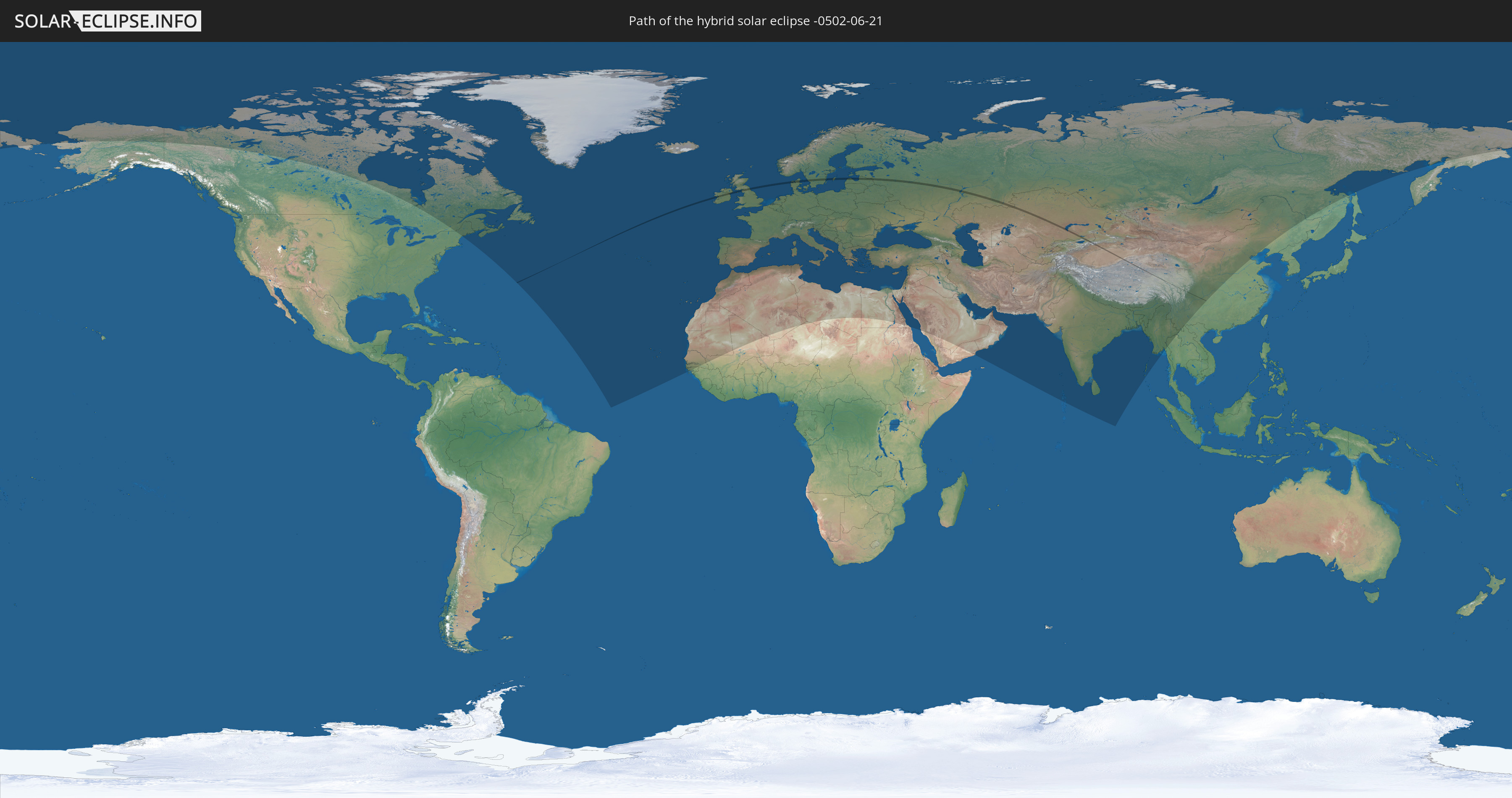
Die Sonnenfinsternis am 06/21/-0502 kann man in 105 Ländern als partielle Sonnenfinsternis beobachten.
Der Finsternispfad verläuft durch 11 Länder. Nur in diesen Ländern ist sie als hybrid Sonnenfinsternis zu sehen.
In den folgenden Ländern ist die Sonnenfinsternis hybrid zu sehen
 Russia
 Republic of Ireland
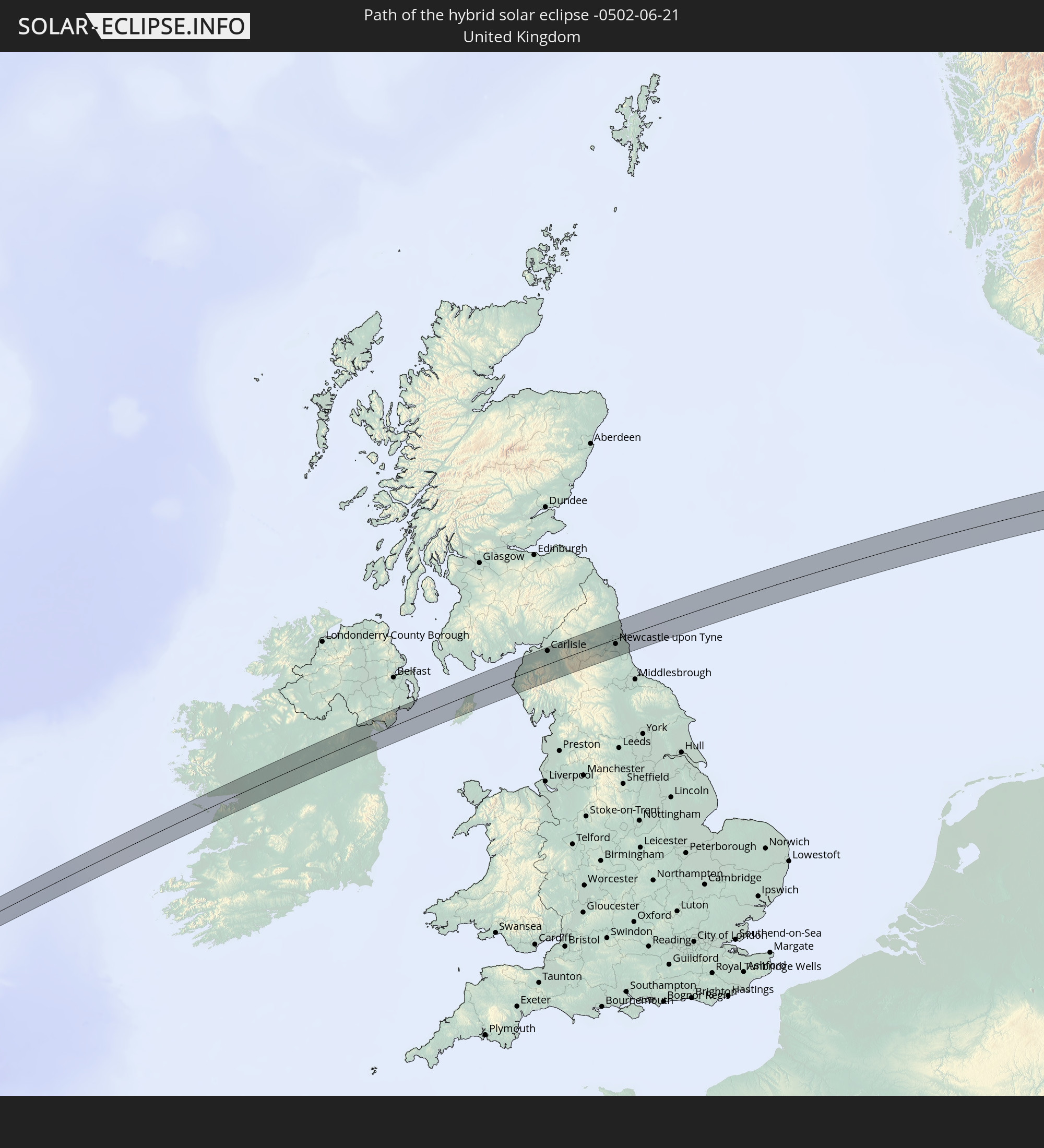 United Kingdom
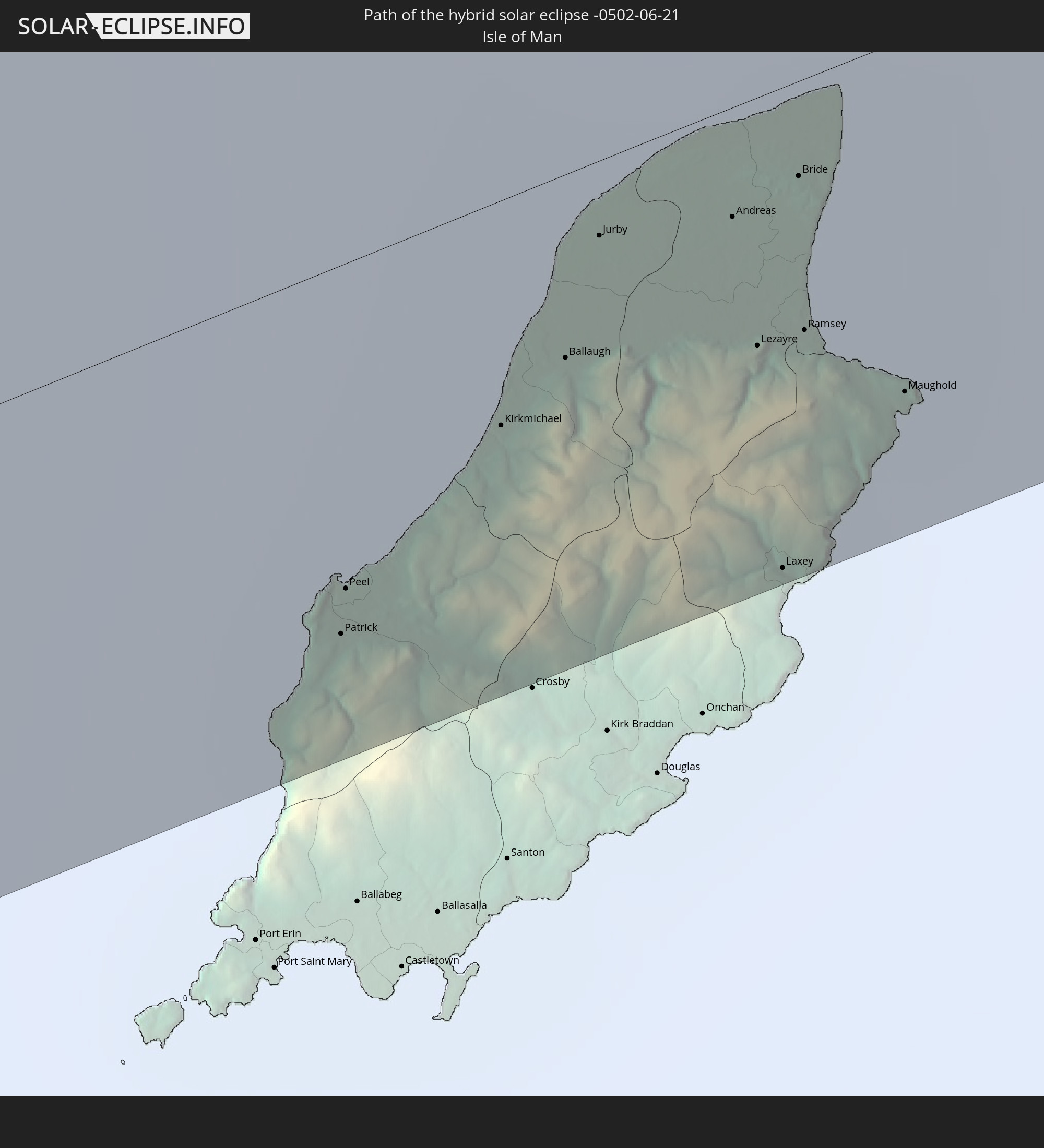 Isle of Man
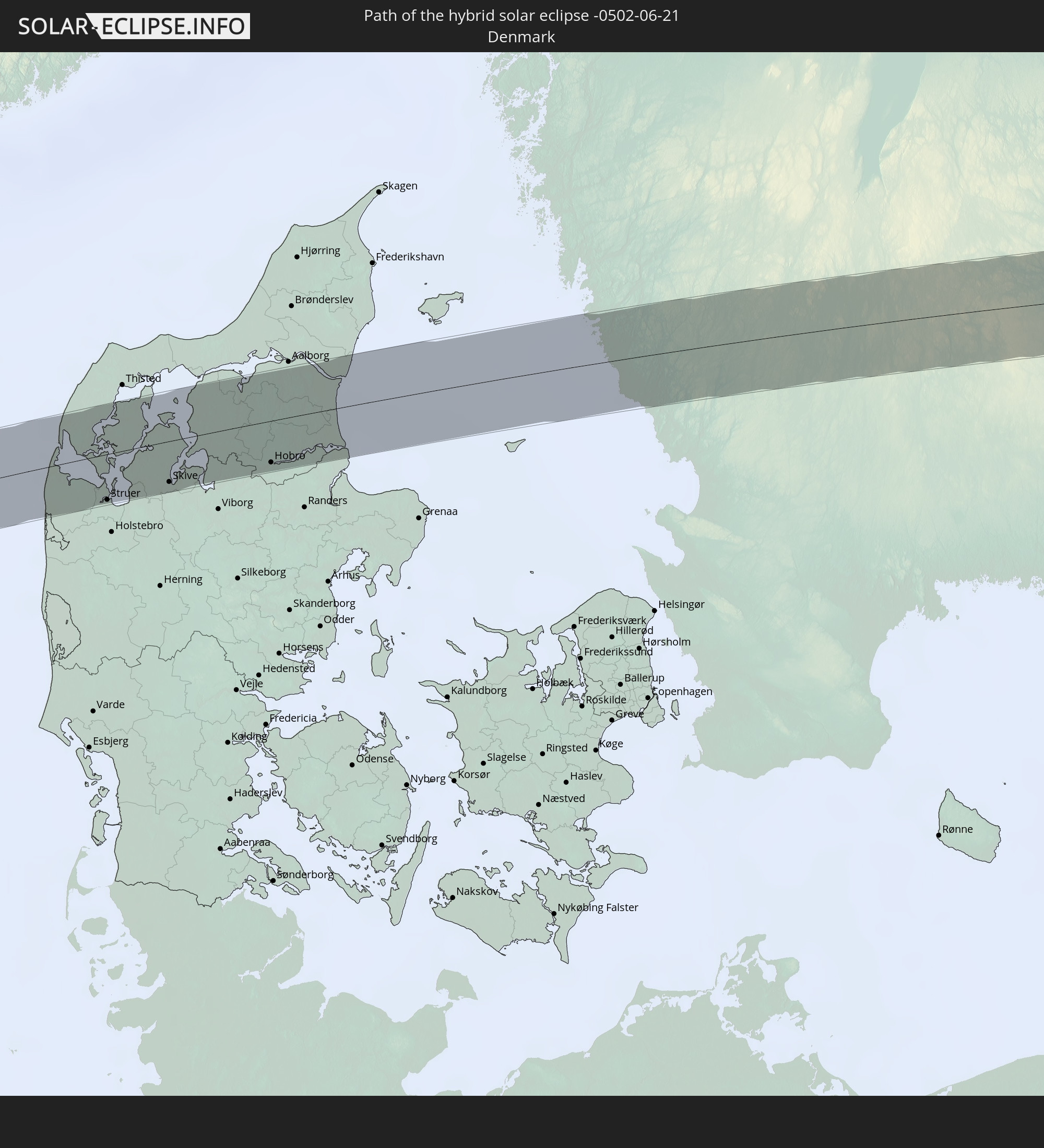 Denmark
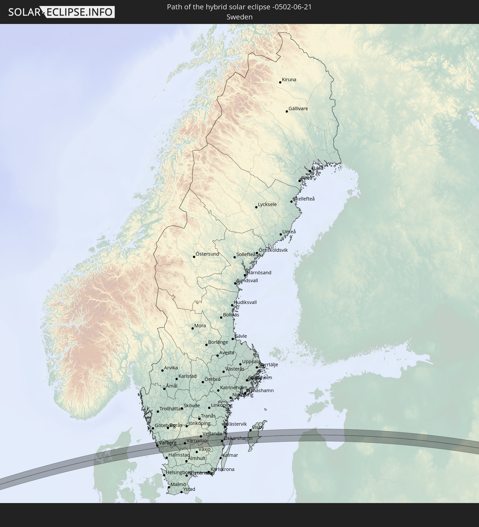 Sweden
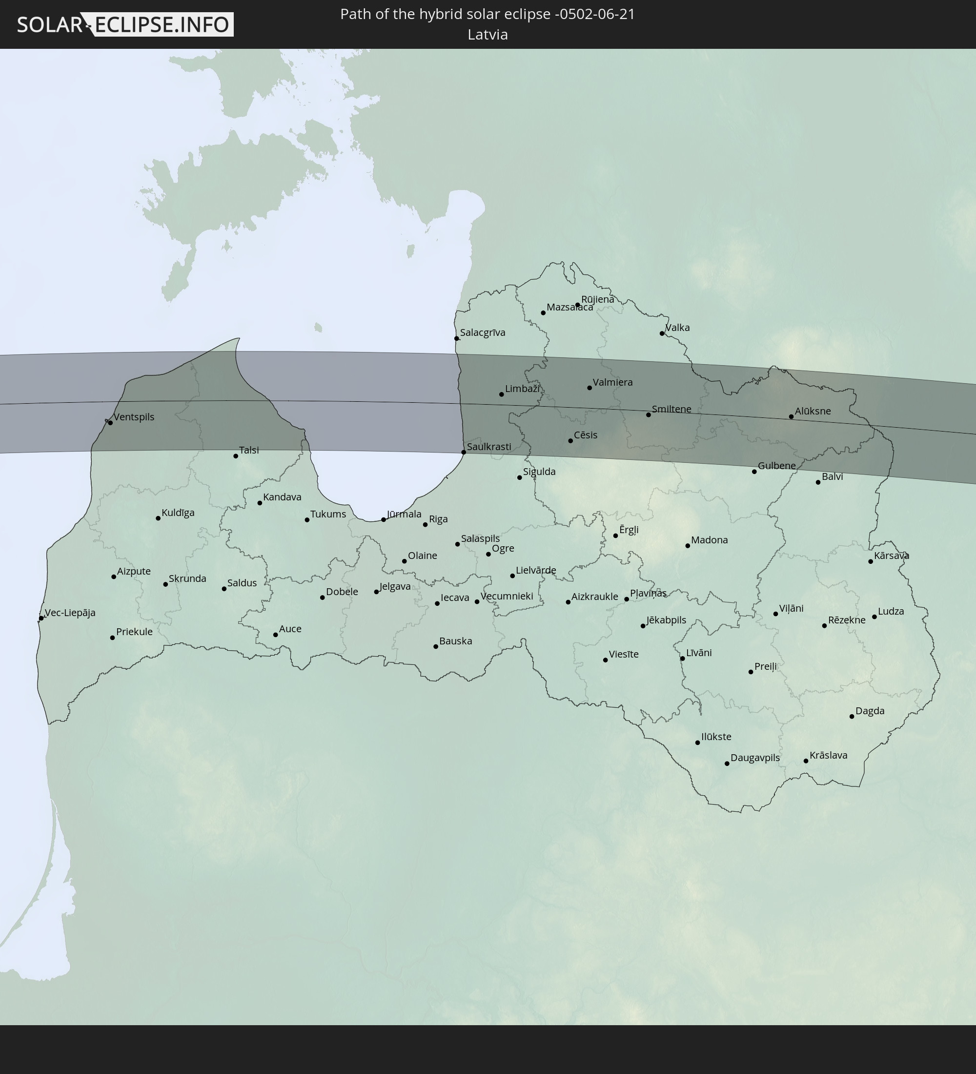 Latvia
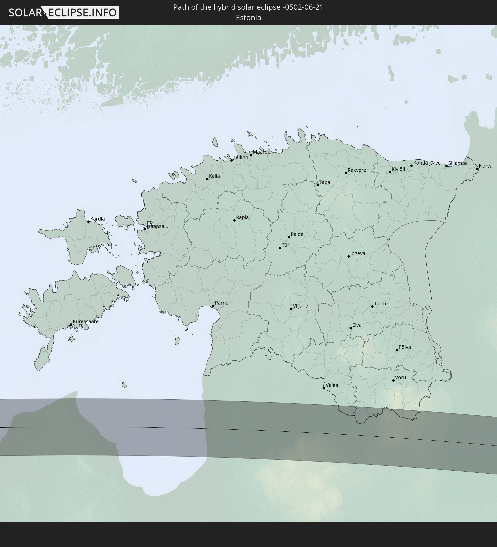 Estonia
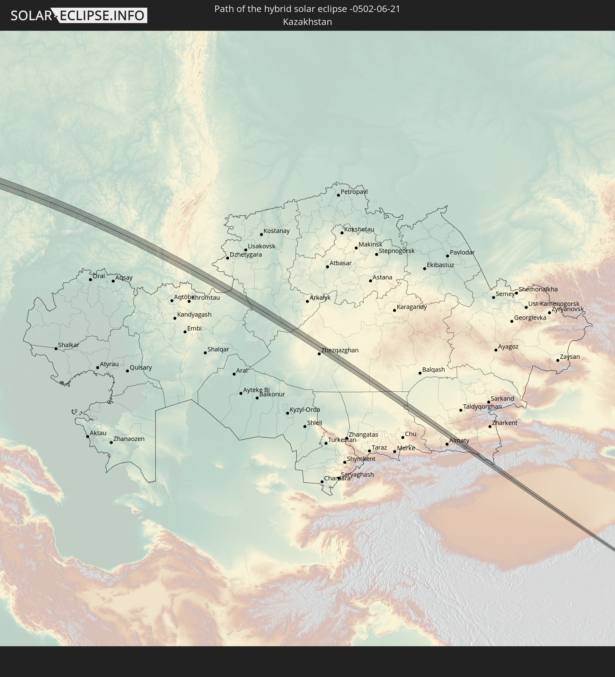 Kazakhstan
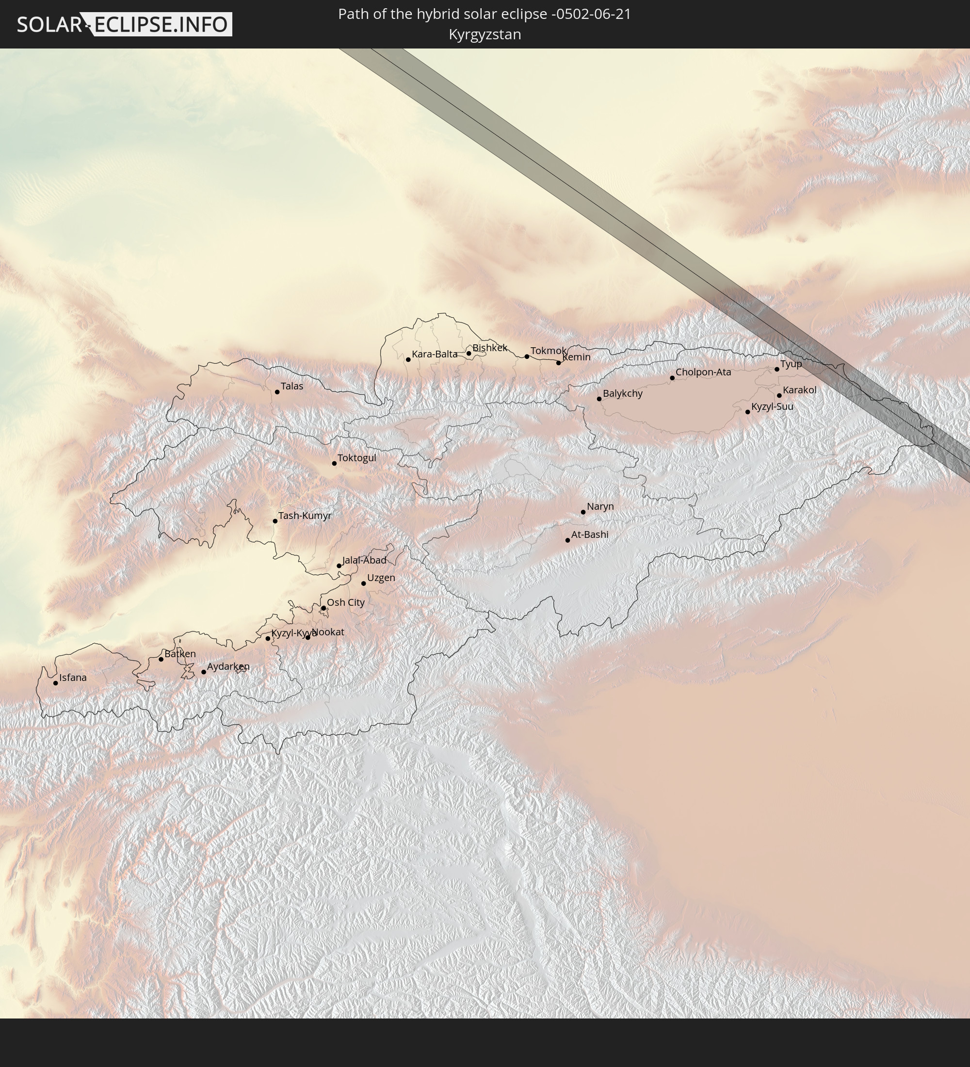 Kyrgyzstan
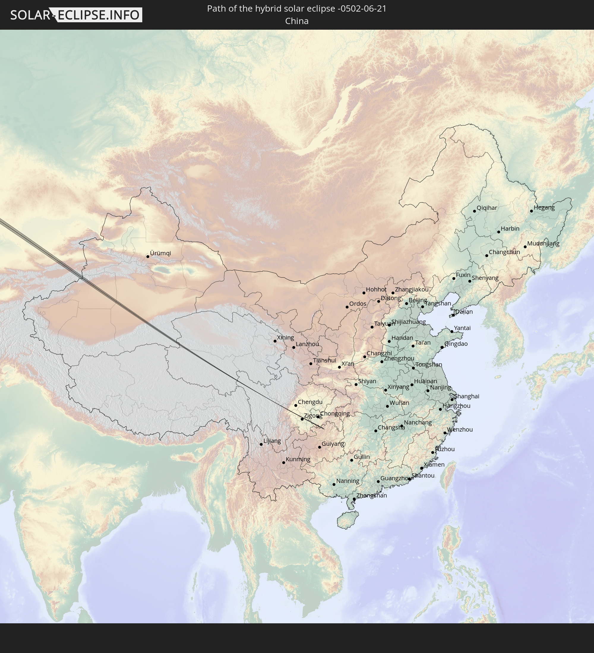 China
China
In den folgenden Ländern ist die Sonnenfinsternis partiell zu sehen
 Russia
 United States
 Canada
 Greenland
 Saint Pierre and Miquelon
 Portugal
 Cabo Verde
 Iceland
 Spain
Spain
 Senegal
 Mauritania
 The Gambia
 Guinea-Bissau
 Morocco
 Mali
Mali
 Republic of Ireland
 Svalbard and Jan Mayen
 Algeria
 United Kingdom
 Faroe Islands
 Gibraltar
 France
 Isle of Man
 Guernsey
 Jersey
 Niger
Niger
 Andorra
 Belgium
 Netherlands
 Norway
 Luxembourg
 Germany
 Switzerland
 Italy
Italy
 Monaco
 Tunisia
 Denmark
 Libya
Libya
 Liechtenstein
 Austria
 Sweden
 Czechia
 San Marino
 Vatican City
 Slovenia
 Croatia
 Poland
 Malta
Malta
 Bosnia and Herzegovina
 Hungary
 Slovakia
 Montenegro
 Serbia
 Albania
 Åland Islands
 Greece
 Romania
 Republic of Macedonia
 Finland
 Lithuania
 Latvia
 Estonia
 Sudan
Sudan
 Ukraine
 Bulgaria
 Belarus
 Egypt
Egypt
 Turkey
 Moldova
 Cyprus
 State of Palestine
 Israel
 Saudi Arabia
 Jordan
 Lebanon
 Syria
Syria
 Iraq
Iraq
 Georgia
 Yemen
Yemen
 Armenia
 Iran
Iran
 Azerbaijan
 Kazakhstan
 Kuwait
 Bahrain
 Qatar
Qatar
 United Arab Emirates
 Oman
Oman
 Turkmenistan
 Uzbekistan
 Afghanistan
 Pakistan
 Tajikistan
 India
India
 Kyrgyzstan
 Maldives
 China
China
 Sri Lanka
 Nepal
Nepal
 Mongolia
 Bangladesh
 Bhutan
 Myanmar
 Thailand
 Laos
Laos
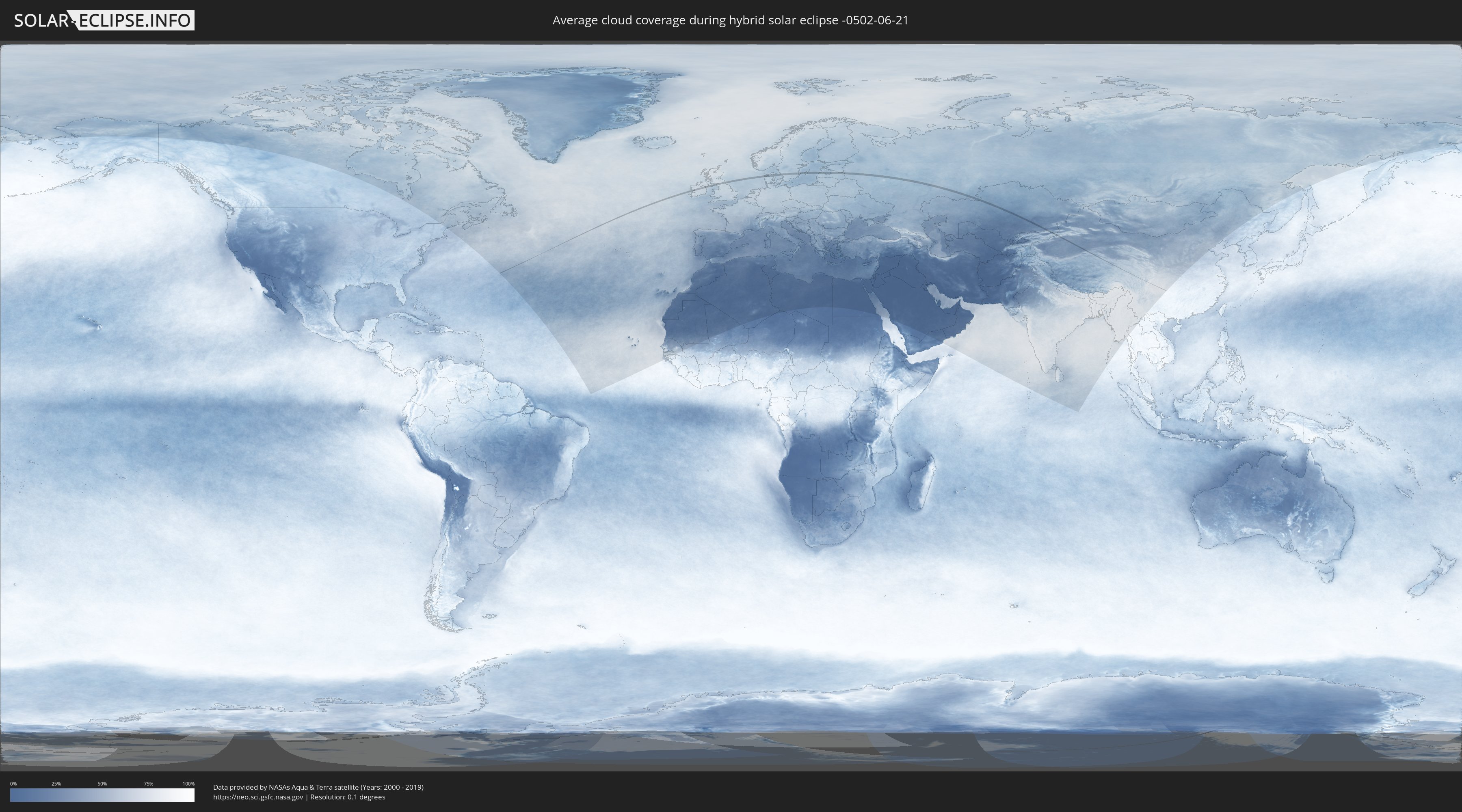
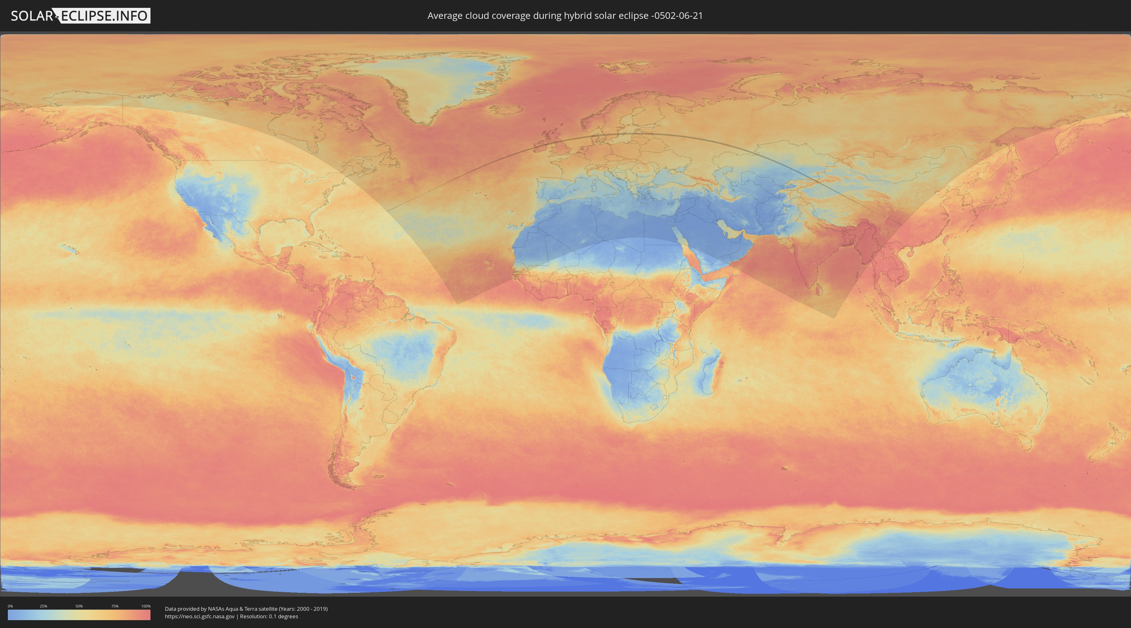
How will be the weather during the hybrid solar eclipse on 06/21/-0502?
Where is the best place to see the hybrid solar eclipse of 06/21/-0502?
The following maps show the average cloud coverage for the day of the hybrid solar eclipse.
With the help of these maps, it is possible to find the place along the eclipse path, which has the best
chance of a cloudless sky.
Nevertheless, you should consider local circumstances and inform about the weather of your chosen
observation site.
The data is provided by NASAs satellites
AQUA and TERRA.
The cloud maps are averaged over a period of 19 years (2000 - 2019).
Detailed country maps
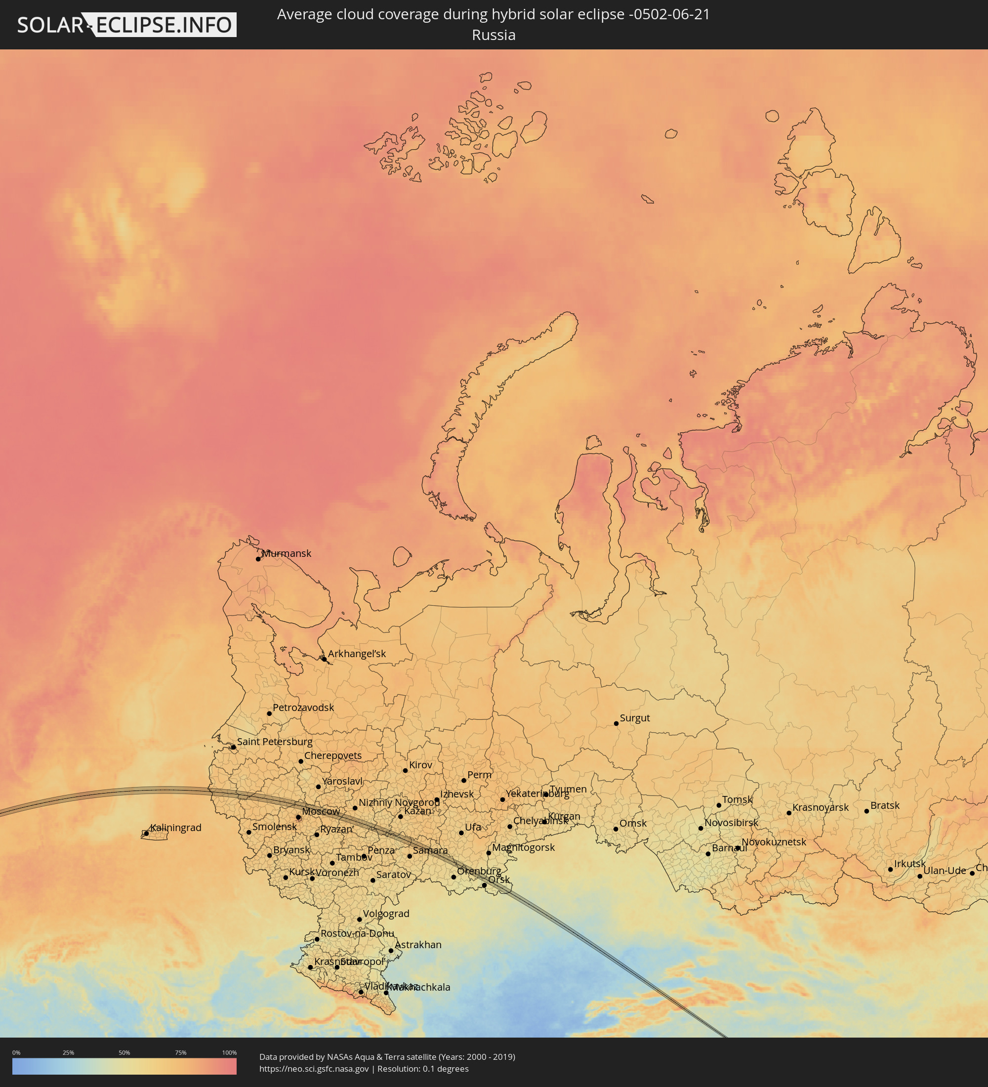 Russia
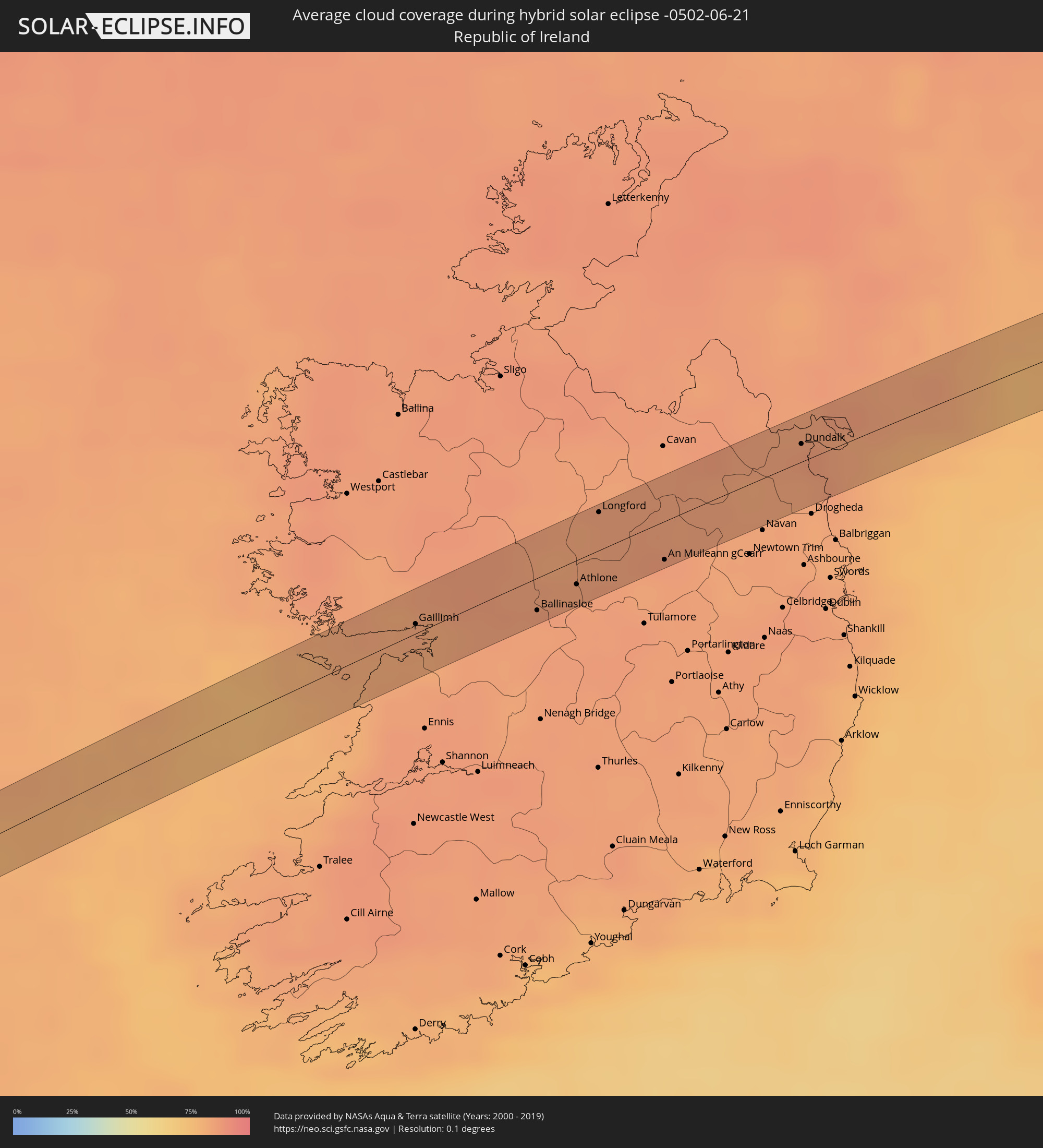 Republic of Ireland
 United Kingdom
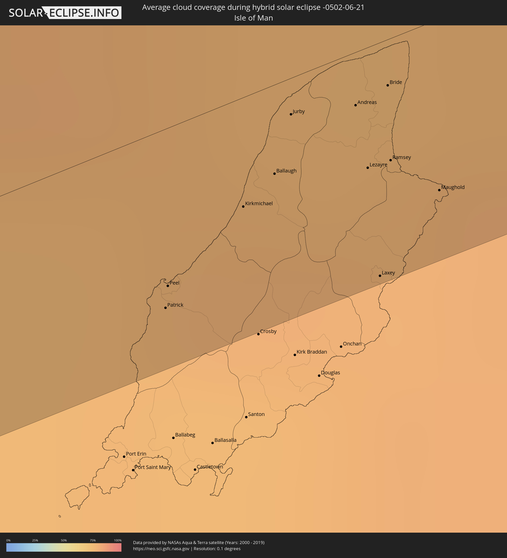 Isle of Man
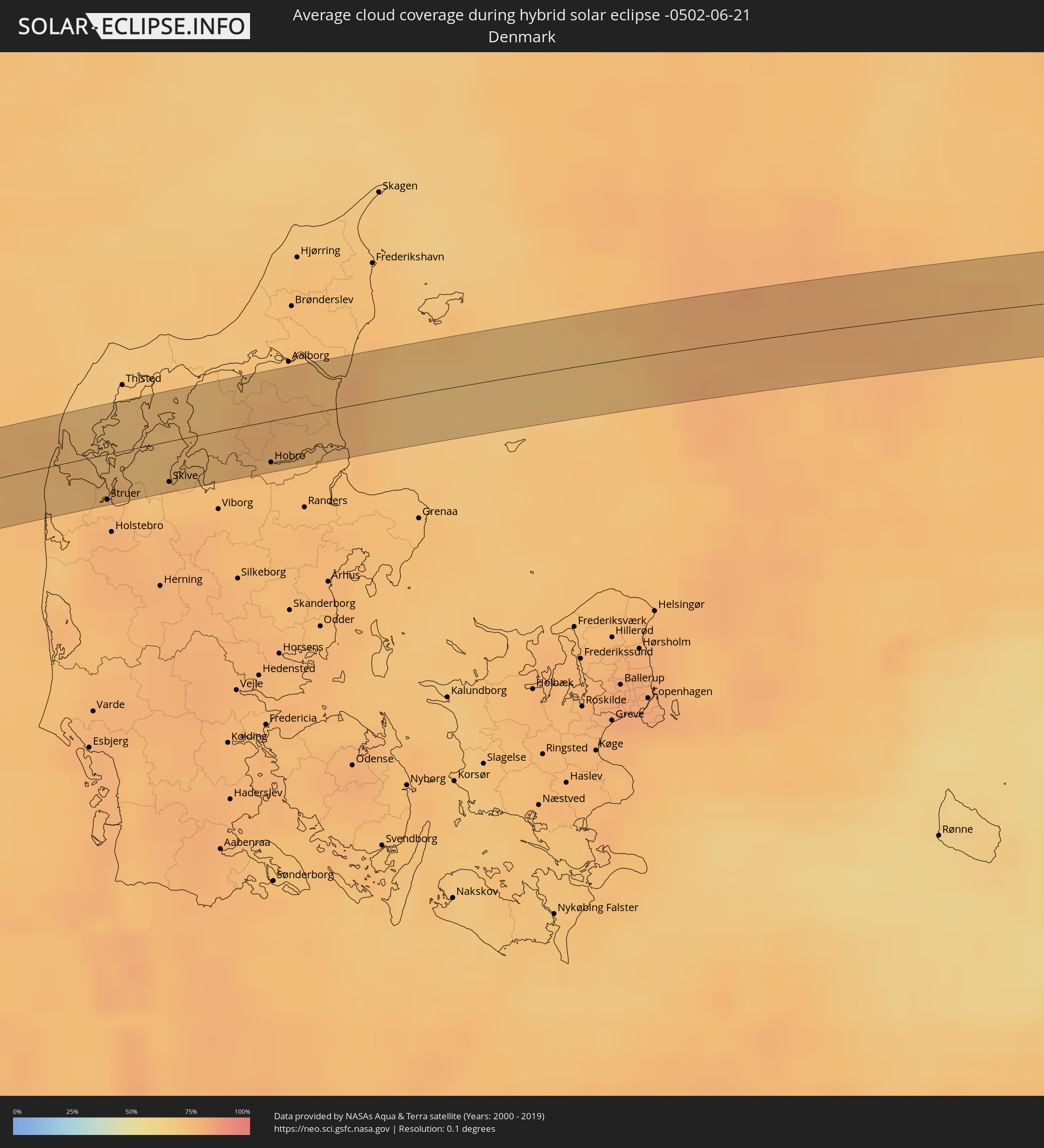 Denmark
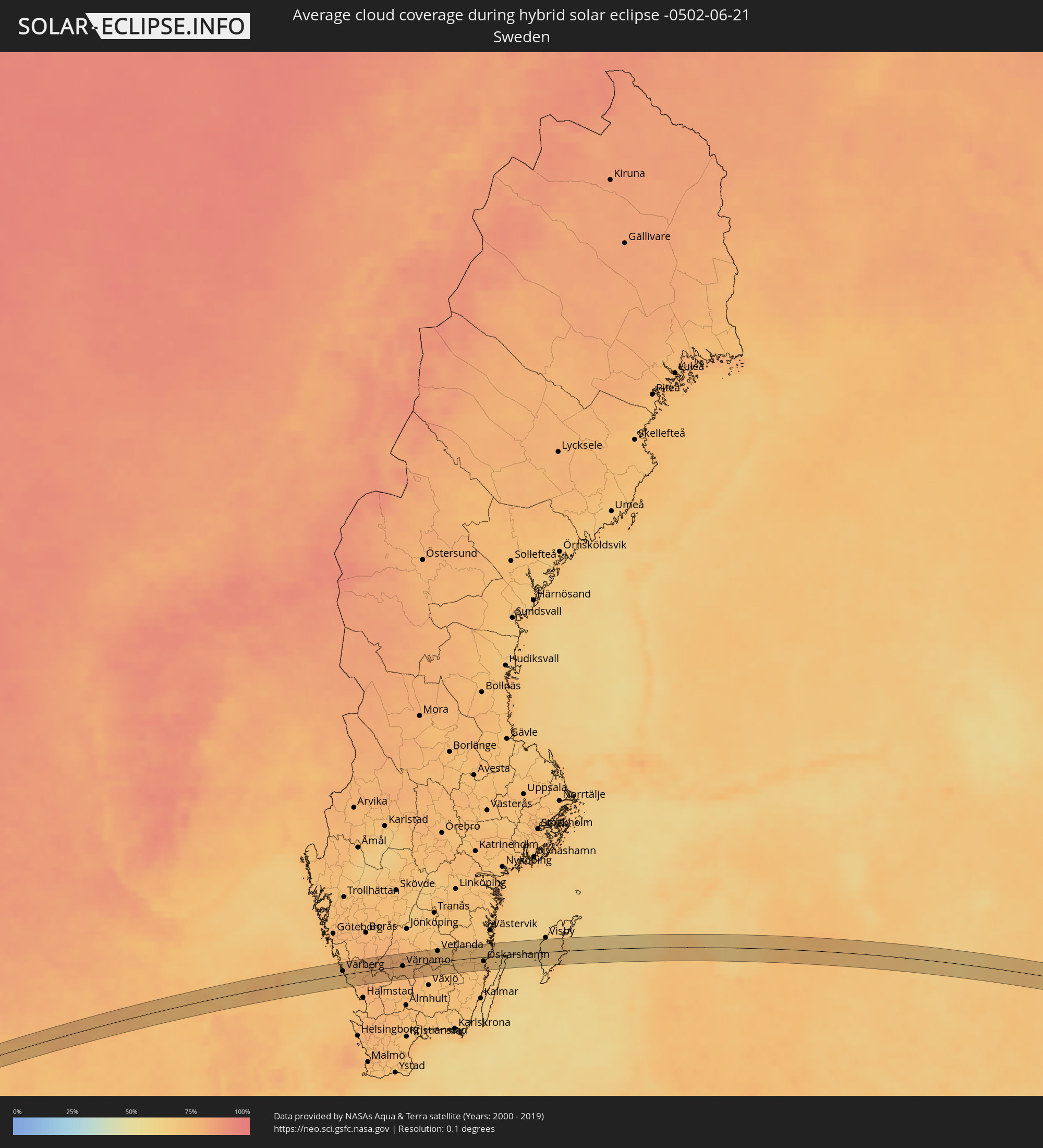 Sweden
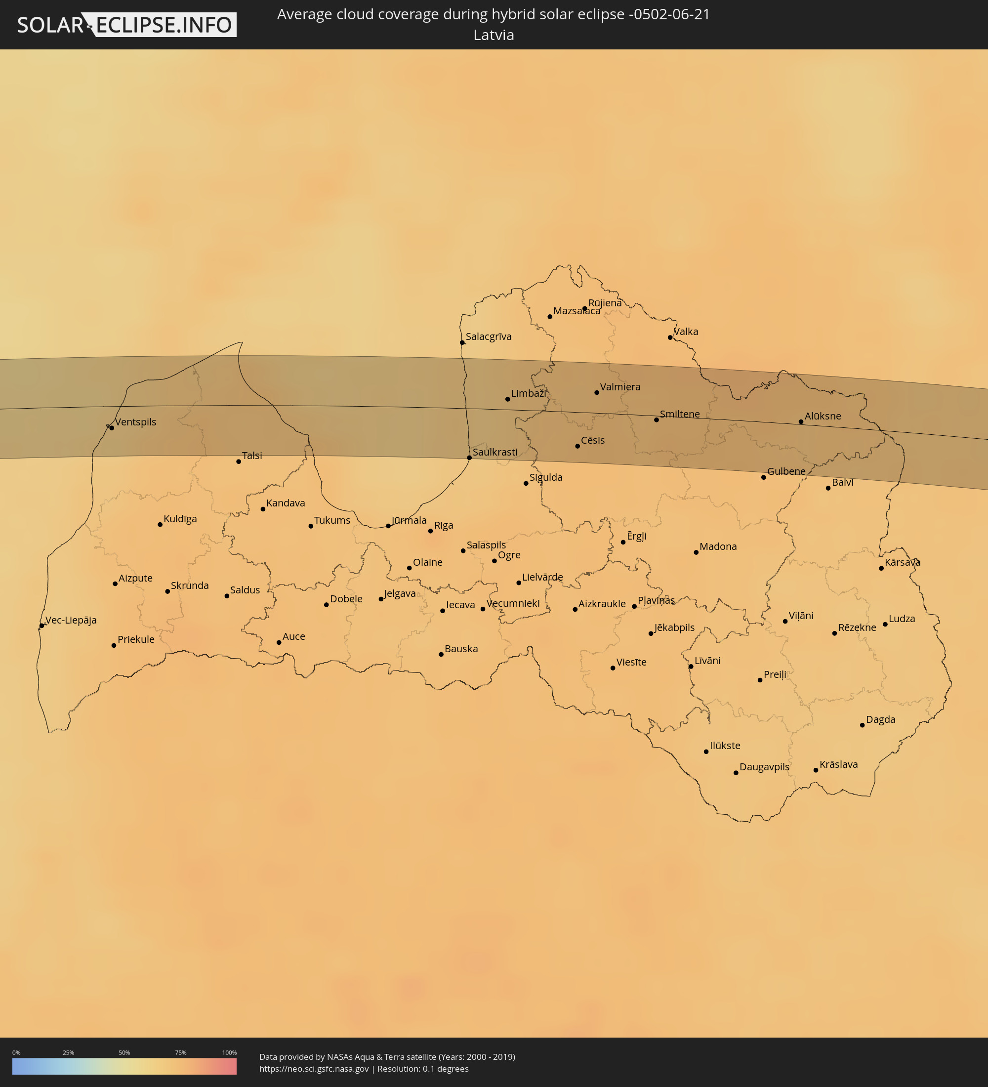 Latvia
 Estonia
 Kazakhstan
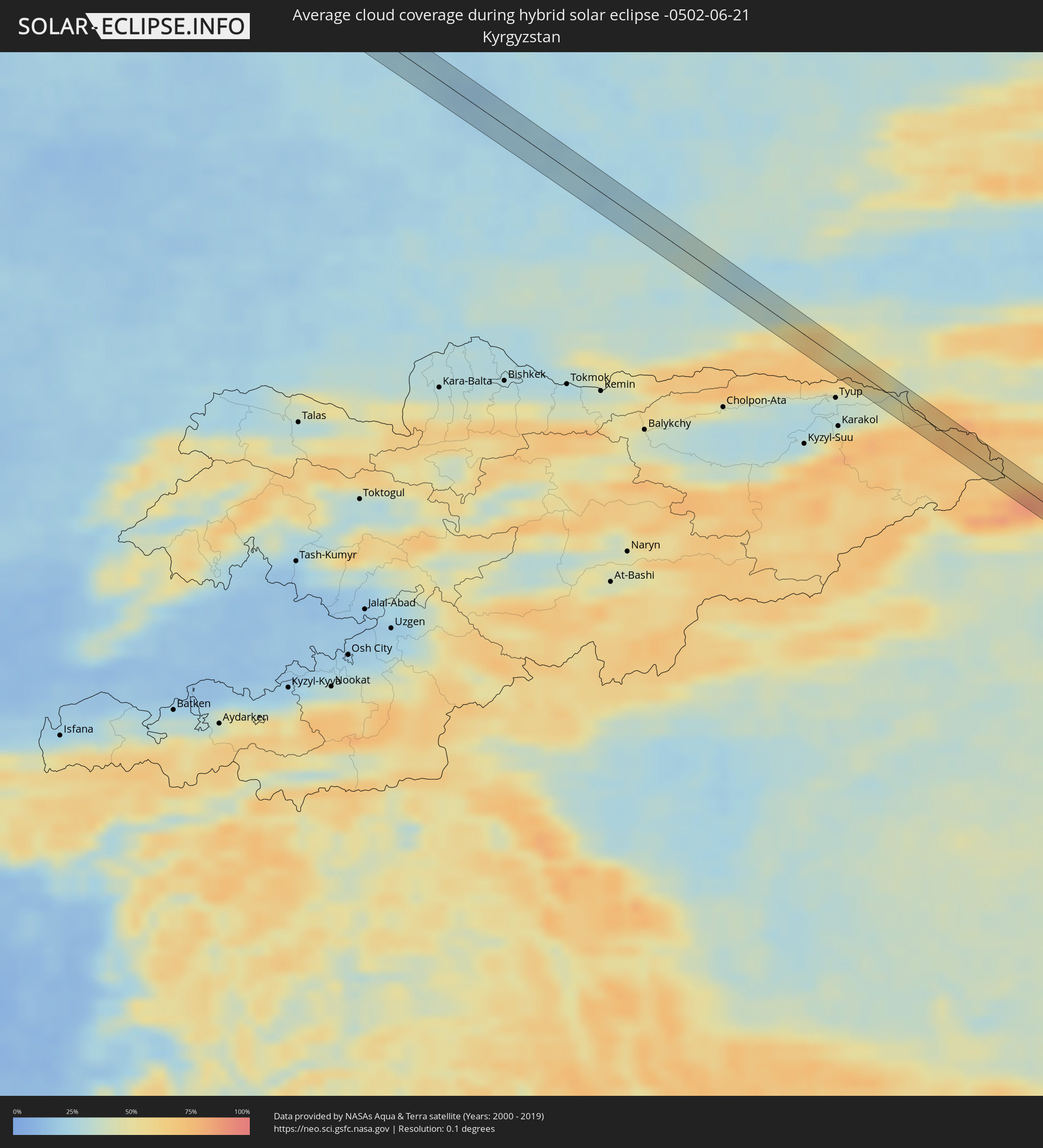 Kyrgyzstan
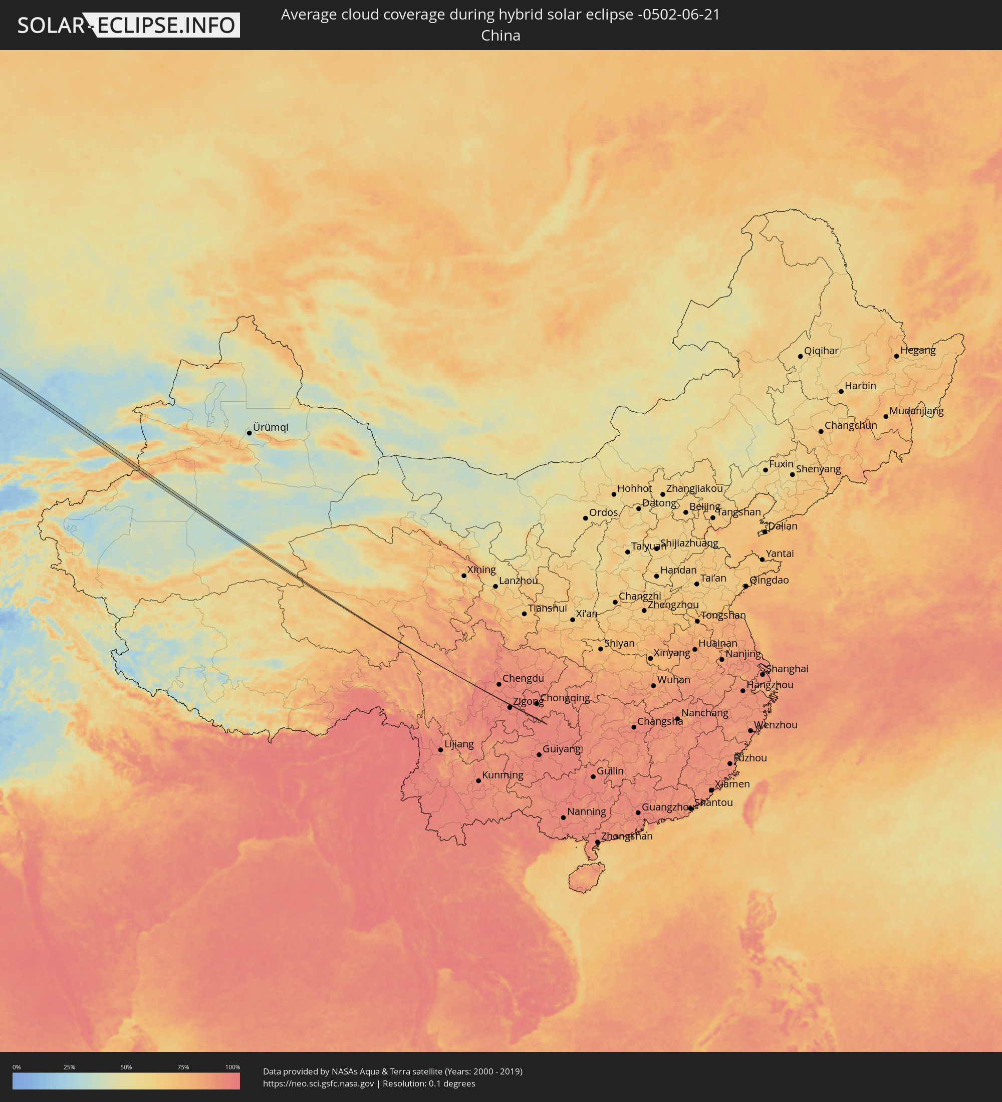 China
China
Cities inside the path of the eclipse
The following table shows all locations with a population of more than 5,000 inside the eclipse path. Cities which have more than 100,000 inhabitants are marked bold. A click at the locations opens a detailed map.
| City | Type | Eclipse duration | Local time of max. eclipse | Distance to central line | Ø Cloud coverage |
|
Gaillimh, Connaught
|
total | - | 08:51:46 UTC-00:25 | 4 km | 83% |
|
Loughrea, Connaught
|
total | - | 08:52:06 UTC-00:25 | 21 km | 84% |
|
Ballinasloe, Connaught
|
total | - | 08:52:37 UTC-00:25 | 20 km | 84% |
|
Roscommon, Connaught
|
total | - | 08:53:07 UTC-00:25 | 18 km | 83% |
|
Athlone, Leinster
|
total | - | 08:53:02 UTC-00:25 | 10 km | 86% |
|
Longford, Leinster
|
total | - | 08:53:37 UTC-00:25 | 21 km | 84% |
|
An Muileann gCearr, Leinster
|
total | - | 08:53:45 UTC-00:25 | 16 km | 84% |
|
Dundalk, Leinster
|
total | - | 08:55:21 UTC-00:25 | 12 km | 85% |
|
Warrenpoint, Northern Ireland
|
total | - | 08:55:39 UTC-00:25 | 18 km | 84% |
|
Kilkeel, Northern Ireland
|
total | - | 09:21:11 UTC+00:00 | 3 km | 83% |
|
Newcastle, Northern Ireland
|
total | - | 09:21:32 UTC+00:00 | 22 km | 84% |
|
Patrick, Patrick
|
total | - | 09:22:43 UTC+00:00 | 21 km | 75% |
|
Peel, Peel
|
total | - | 09:22:45 UTC+00:00 | 21 km | 75% |
|
Kirkmichael, Michael
|
total | - | 09:22:56 UTC+00:00 | 13 km | 77% |
|
Ballaugh, Ballaugh
|
total | - | 09:23:01 UTC+00:00 | 10 km | 78% |
|
Jurby, Jurby
|
total | - | 09:23:07 UTC+00:00 | 4 km | 76% |
|
Andreas, Andreas
|
total | - | 09:23:13 UTC+00:00 | 5 km | 76% |
|
Lezayre, Lezayre
|
total | - | 09:23:09 UTC+00:00 | 10 km | 77% |
|
Laxey, Laxey
|
total | - | 09:23:03 UTC+00:00 | 19 km | 78% |
|
Bride, Bride
|
total | - | 09:23:17 UTC+00:00 | 7 km | 76% |
|
Ramsey, Ramsey
|
total | - | 09:23:12 UTC+00:00 | 11 km | 77% |
|
Maughold, Maughold
|
total | - | 09:23:14 UTC+00:00 | 16 km | 78% |
|
Whitehaven, England
|
total | - | 09:24:21 UTC+00:00 | 10 km | 79% |
|
Egremont, England
|
total | - | 09:24:18 UTC+00:00 | 16 km | 80% |
|
Cleator Moor, England
|
total | - | 09:24:23 UTC+00:00 | 11 km | 80% |
|
Maryport, England
|
total | - | 09:24:40 UTC+00:00 | 10 km | 79% |
|
Cockermouth, England
|
total | - | 09:24:44 UTC+00:00 | 10 km | 82% |
|
Carlisle, England
|
total | - | 09:25:30 UTC+00:00 | 18 km | 85% |
|
Penrith, England
|
total | - | 09:25:23 UTC+00:00 | 17 km | 85% |
|
Hexham, England
|
total | - | 09:26:29 UTC+00:00 | 7 km | 82% |
|
Prudhoe, England
|
total | - | 09:26:45 UTC+00:00 | 10 km | 82% |
|
Consett, England
|
total | - | 09:26:38 UTC+00:00 | 15 km | 83% |
|
Darras Hall, England
|
total | - | 09:26:56 UTC+00:00 | 17 km | 83% |
|
Ponteland, England
|
total | - | 09:26:59 UTC+00:00 | 16 km | 83% |
|
Annfield Plain, England
|
total | - | 09:26:44 UTC+00:00 | 20 km | 82% |
|
Blaydon-on-Tyne, England
|
total | - | 09:26:54 UTC+00:00 | 17 km | 84% |
|
Morpeth, England
|
total | - | 09:27:12 UTC+00:00 | 18 km | 82% |
|
Benwell, England
|
total | - | 09:26:58 UTC+00:00 | 14 km | 84% |
|
Newcastle upon Tyne, England
|
total | - | 09:27:01 UTC+00:00 | 12 km | 85% |
|
Seaton Delaval, England
|
total | - | 09:27:15 UTC+00:00 | 3 km | 82% |
|
Newbiggin-by-the-Sea, England
|
total | - | 09:27:24 UTC+00:00 | 15 km | 81% |
|
Blyth, England
|
total | - | 09:27:20 UTC+00:00 | 8 km | 82% |
|
The Boldons, England
|
total | - | 09:27:09 UTC+00:00 | 13 km | 82% |
|
Sunderland, England
|
total | - | 09:27:11 UTC+00:00 | 18 km | 82% |
|
Lemvig, Central Jutland
|
total | - | 10:40:32 UTC+01:00 | 18 km | 75% |
|
Struer, Central Jutland
|
total | - | 10:40:50 UTC+01:00 | 20 km | 76% |
|
Nykøbing Mors, North Denmark
|
total | - | 10:41:26 UTC+01:00 | 12 km | 71% |
|
Skive, Central Jutland
|
total | - | 10:41:29 UTC+01:00 | 18 km | 73% |
|
Aars, North Denmark
|
total | - | 10:42:17 UTC+01:00 | 3 km | 77% |
|
Hobro, North Denmark
|
total | - | 10:42:30 UTC+01:00 | 23 km | 74% |
|
Støvring, North Denmark
|
total | - | 10:42:46 UTC+01:00 | 11 km | 77% |
|
Hadsund, North Denmark
|
total | - | 10:42:59 UTC+01:00 | 15 km | 75% |
|
Varberg, Halland
|
total | - | 10:46:03 UTC+01:00 | 16 km | 70% |
|
Falkenberg, Halland
|
total | - | 10:46:13 UTC+01:00 | 18 km | 74% |
|
Gislaved, Jönköping
|
total | - | 10:47:52 UTC+01:00 | 18 km | 78% |
|
Värnamo, Jönköping
|
total | - | 10:48:27 UTC+01:00 | 2 km | 78% |
|
Sävsjö, Jönköping
|
total | - | 10:49:25 UTC+01:00 | 23 km | 75% |
|
Vetlanda, Jönköping
|
total | - | 10:49:59 UTC+01:00 | 20 km | 75% |
|
Hultsfred, Kalmar
|
total | - | 10:51:02 UTC+01:00 | 22 km | 72% |
|
Oskarshamn, Kalmar
|
total | - | 10:51:43 UTC+01:00 | 9 km | 71% |
|
Ventspils, Ventspils
|
total | - | 11:35:22 UTC+01:36 | 11 km | 64% |
|
Dundaga, Dundaga
|
total | - | 11:36:28 UTC+01:36 | 9 km | 71% |
|
Roja, Rojas
|
total | - | 11:37:06 UTC+01:36 | 12 km | 71% |
|
Mērsrags, Mesraga
|
total | - | 11:37:31 UTC+01:36 | 19 km | 71% |
|
Saulkrasti, Saulkrastu
|
total | - | 11:39:19 UTC+01:36 | 24 km | 67% |
|
Limbaži, Limbažu Rajons
|
total | - | 11:39:45 UTC+01:36 | 5 km | 67% |
|
Stalbe, Pārgaujas
|
total | - | 11:40:11 UTC+01:36 | 10 km | 71% |
|
Cēsis, Cēsu Rajons
|
total | - | 11:40:31 UTC+01:36 | 16 km | 74% |
|
Kocēni, Kocēni
|
total | - | 11:40:36 UTC+01:36 | 7 km | 72% |
|
Priekuļi, Priekuļi
|
total | - | 11:40:38 UTC+01:36 | 16 km | 73% |
|
Valmiera, Valmieras Rajons
|
total | - | 11:40:44 UTC+01:36 | 9 km | 73% |
|
Murmuiža, Beverīna
|
total | - | 11:40:48 UTC+01:36 | 3 km | 73% |
|
Rauna, Raunas
|
total | - | 11:40:59 UTC+01:36 | 13 km | 73% |
|
Strenči, Strenči
|
total | - | 11:41:05 UTC+01:36 | 20 km | 72% |
|
Smiltene, Smiltene
|
total | - | 11:41:23 UTC+01:36 | 2 km | 74% |
|
Ape, Apes Novads
|
total | - | 11:42:29 UTC+01:36 | 13 km | 74% |
|
Alūksne, Alūksnes Rajons
|
total | - | 11:43:00 UTC+01:36 | 1 km | 70% |
|
Viļaka, Viļaka
|
total | - | 11:43:54 UTC+01:36 | 22 km | 70% |
|
Ostrov, Pskov
|
total | - | 12:38:32 UTC+02:30 | 1 km | 70% |
|
Ostashkov, Tverskaya
|
total | - | 12:45:13 UTC+02:30 | 14 km | 68% |
|
Torzhok, Tverskaya
|
total | - | 12:47:49 UTC+02:30 | 22 km | 66% |
|
Tver, Tverskaya
|
total | - | 12:49:12 UTC+02:30 | 15 km | 71% |
|
Konakovo, Tverskaya
|
total | - | 12:50:29 UTC+02:30 | 16 km | 67% |
|
Dubna, Moscow Oblast
|
total | - | 12:51:01 UTC+02:30 | 16 km | 67% |
|
Zaprudnya, Moscow Oblast
|
total | - | 12:51:29 UTC+02:30 | 4 km | 70% |
|
Dmitrov, Moscow Oblast
|
total | - | 12:51:46 UTC+02:30 | 24 km | 67% |
|
Taldom, Moscow Oblast
|
total | - | 12:51:30 UTC+02:30 | 20 km | 69% |
|
Sergiyev Posad, Moscow Oblast
|
total | - | 12:52:38 UTC+02:30 | 23 km | 69% |
|
Aleksandrov, Vladimir
|
total | - | 12:53:21 UTC+02:30 | 13 km | 67% |
|
Kol’chugino, Vladimir
|
total | - | 12:54:20 UTC+02:30 | 7 km | 67% |
|
Sobinka, Vladimir
|
total | - | 12:55:27 UTC+02:30 | 25 km | 67% |
|
Raduzhnyy, Vladimir
|
total | - | 12:55:52 UTC+02:30 | 18 km | 69% |
|
Vladimir, Vladimir
|
total | - | 12:55:50 UTC+02:30 | 6 km | 69% |
|
Sudogda, Vladimir
|
total | - | 12:56:37 UTC+02:30 | 14 km | 68% |
|
Arzamas, Nizjnij Novgorod
|
total | - | 13:01:06 UTC+02:30 | 18 km | 67% |
|
Alatyr’, Chuvashia
|
total | - | 13:05:14 UTC+02:30 | 22 km | 60% |
|
Cherdakly, Ulyanovsk
|
total | - | 13:58:42 UTC+03:20 | 16 km | 57% |
|
Dimitrovgrad, Ulyanovsk
|
total | - | 13:59:50 UTC+03:20 | 17 km | 67% |
|
Sukhodol, Samara
|
total | - | 14:02:09 UTC+03:20 | 16 km | 68% |
|
Pokhvistnevo, Samara
|
total | - | 14:03:34 UTC+03:20 | 10 km | 65% |
|
Buguruslan, Orenburg
|
total | - | 14:46:09 UTC+04:02 | 10 km | 64% |
|
Kumertau, Bashkortostan
|
total | - | 14:51:11 UTC+04:02 | 21 km | 58% |
|
Yasnyy, Orenburg
|
total | - | 14:58:09 UTC+04:02 | 21 km | 48% |
|
Kapshagay, Almaty Oblysy
|
total | - | 15:42:11 UTC+04:21 | 12 km | 30% |
|
Turgen, Almaty Oblysy
|
total | - | 15:43:12 UTC+04:21 | 15 km | 40% |