Total solar eclipse of 08/19/-0635
| Day of week: | Saturday |
| Maximum duration of eclipse: | 05m08s |
| Maximum width of eclipse path: | 197 km |
| Saros cycle: | 54 |
| Coverage: | 100% |
| Magnitude: | 1.06 |
| Gamma: | -0.0345 |
Wo kann man die Sonnenfinsternis vom 08/19/-0635 sehen?
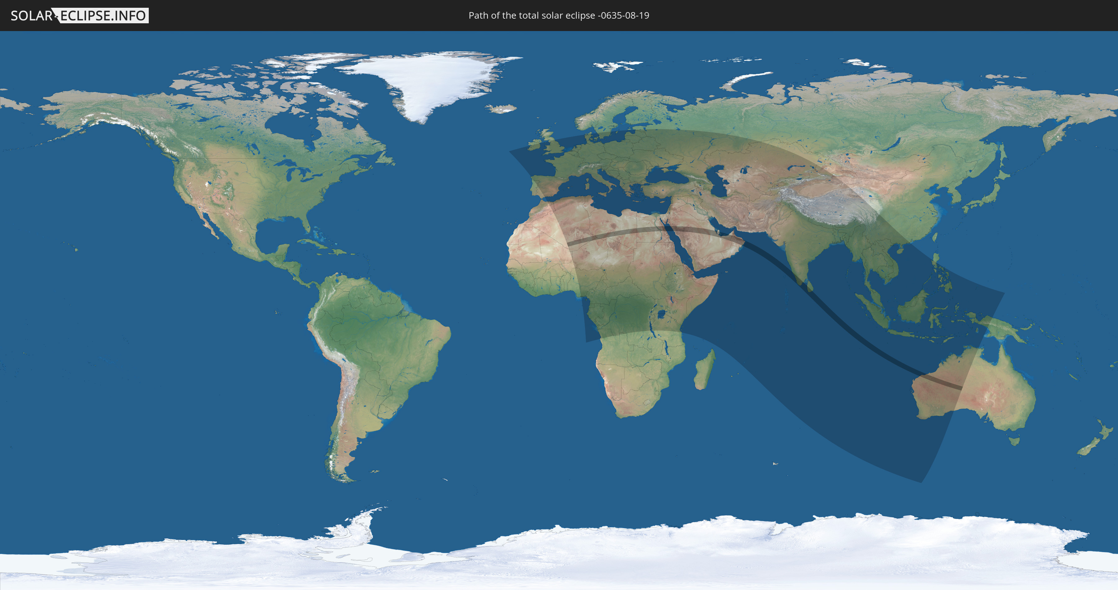
Die Sonnenfinsternis am 08/19/-0635 kann man in 121 Ländern als partielle Sonnenfinsternis beobachten.
Der Finsternispfad verläuft durch 12 Länder. Nur in diesen Ländern ist sie als total Sonnenfinsternis zu sehen.
In den folgenden Ländern ist die Sonnenfinsternis total zu sehen
 Algeria
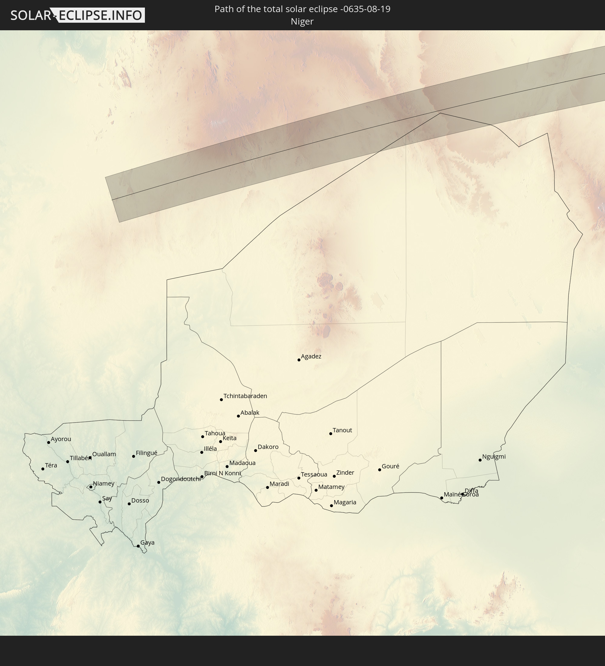 Niger
Niger
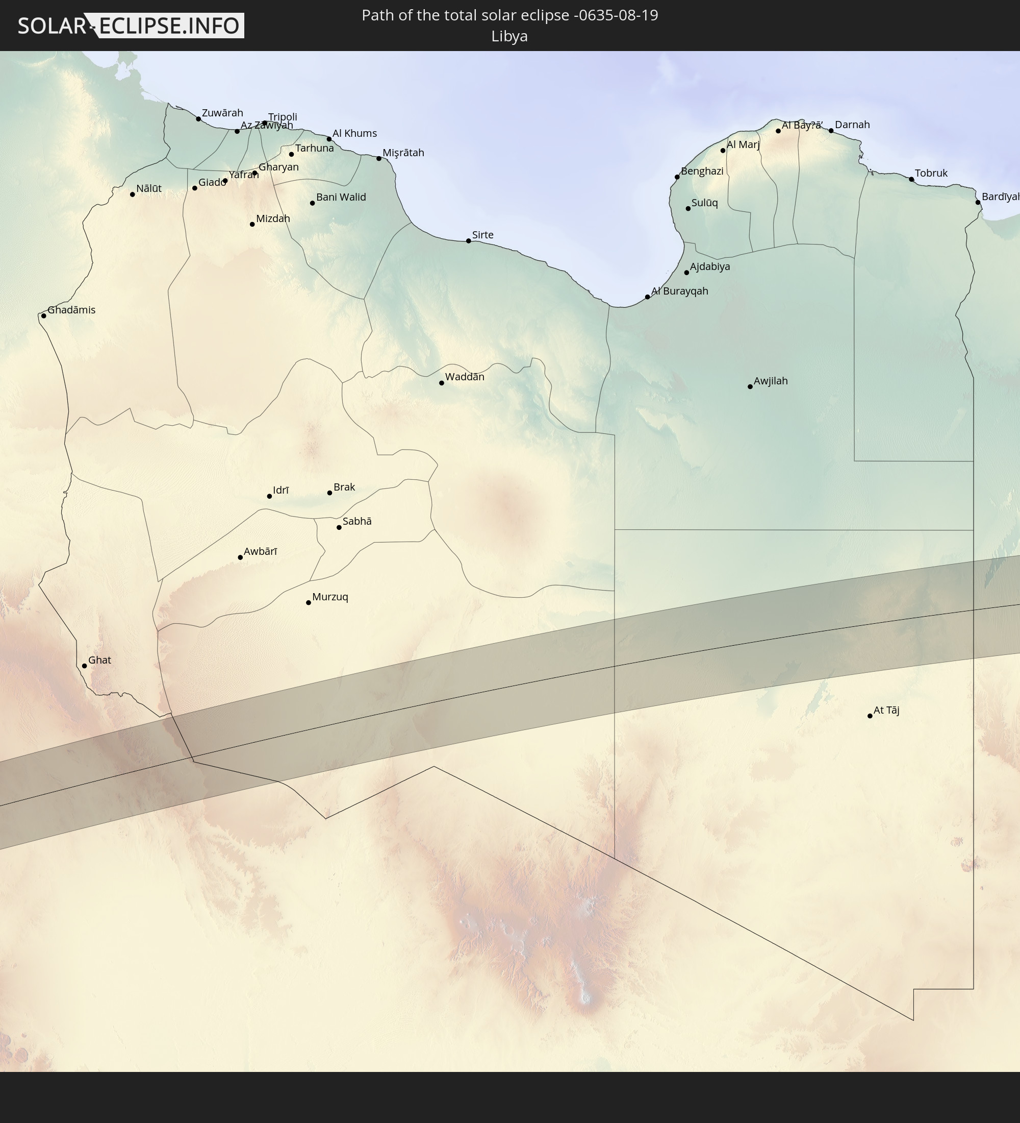 Libya
Libya
 Egypt
Egypt
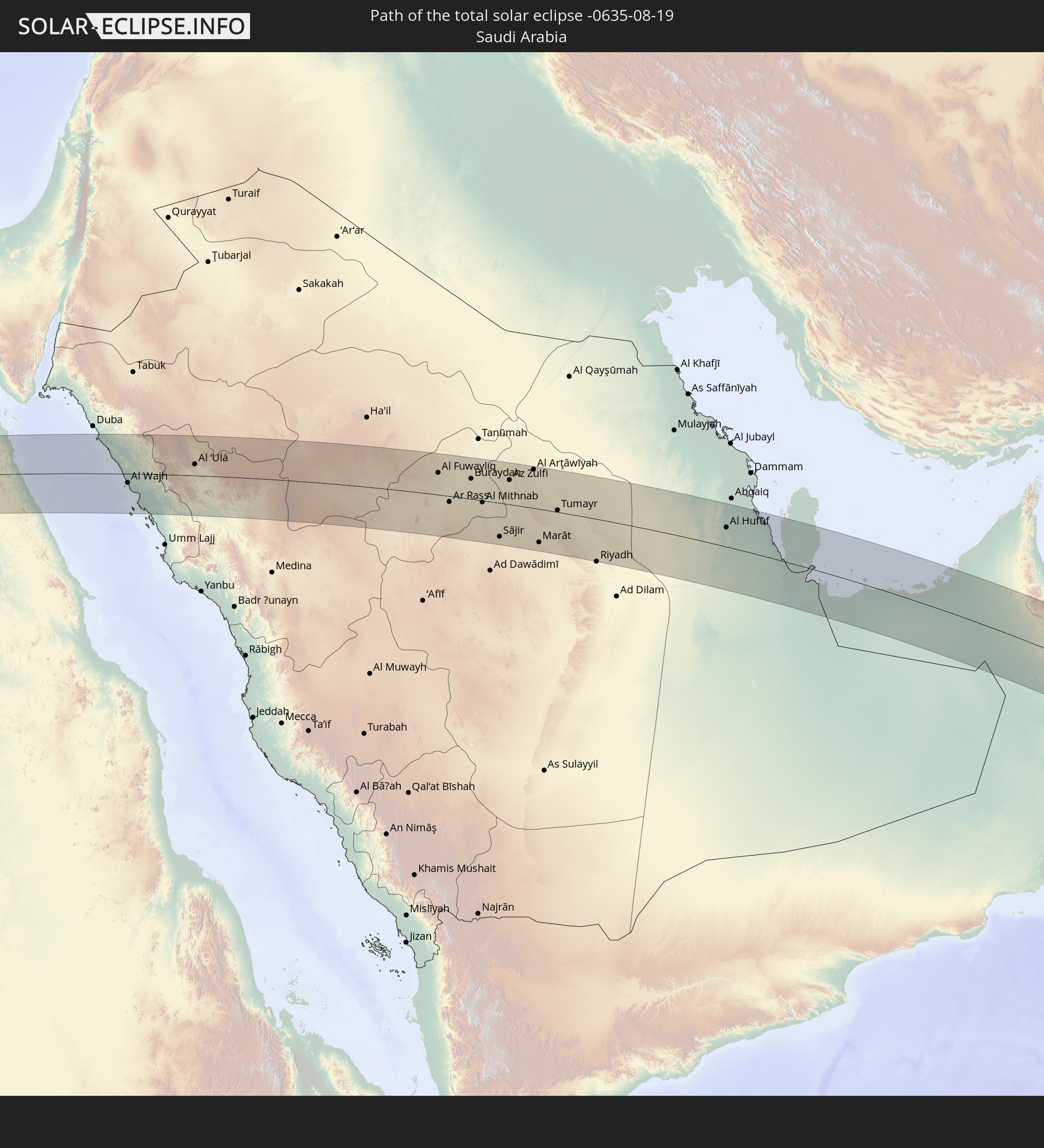 Saudi Arabia
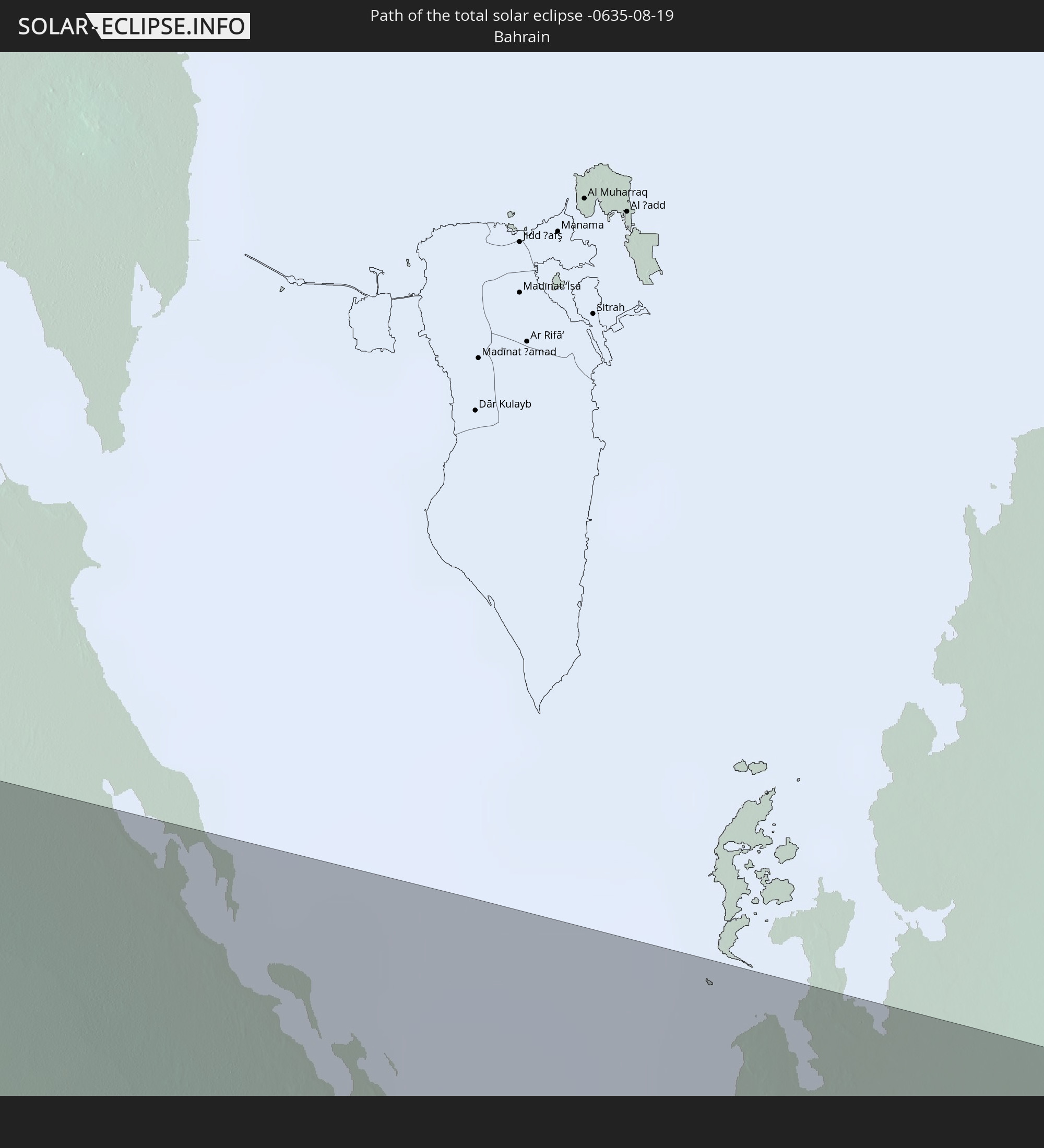 Bahrain
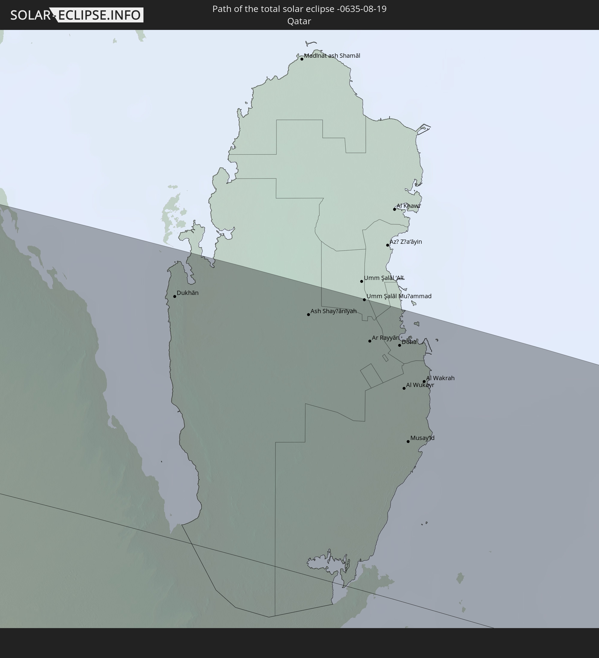 Qatar
Qatar
 United Arab Emirates
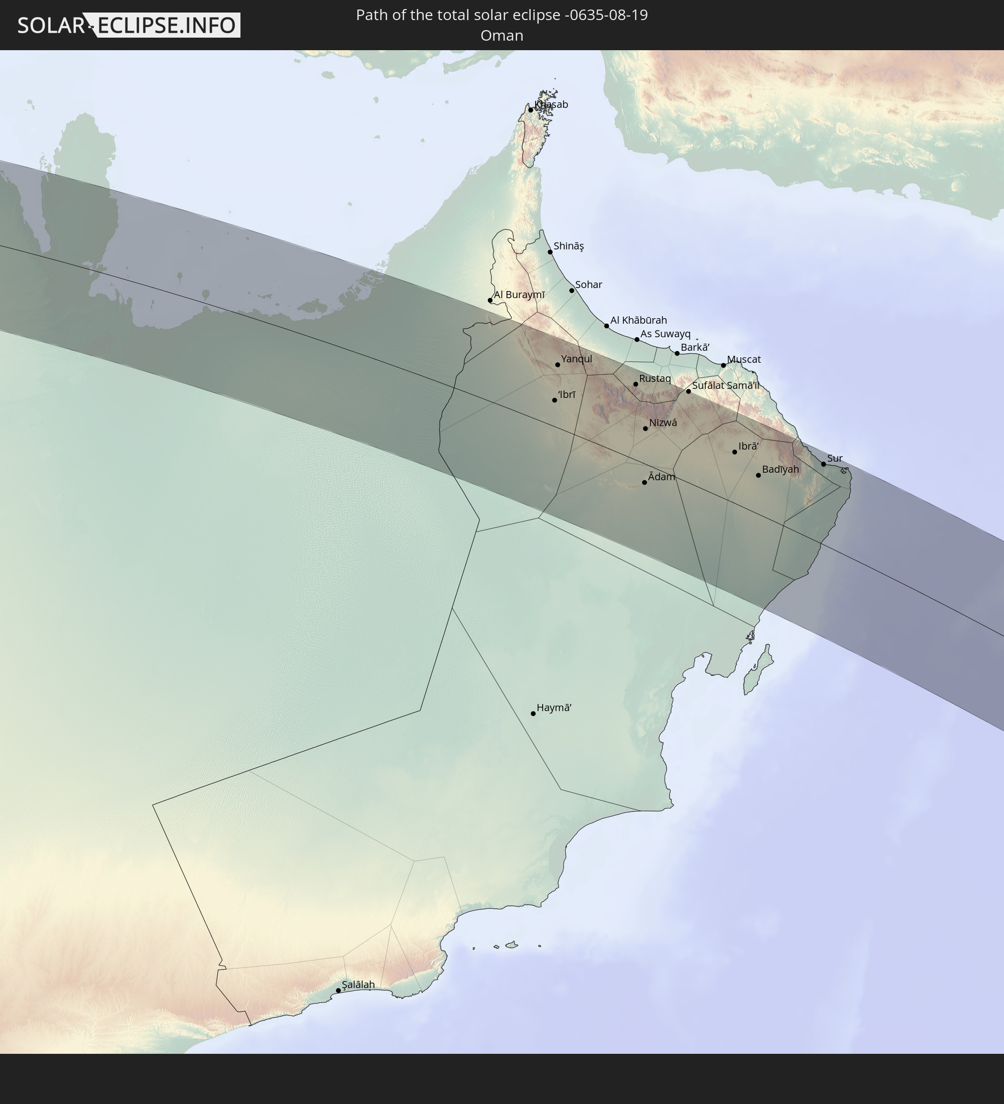 Oman
Oman
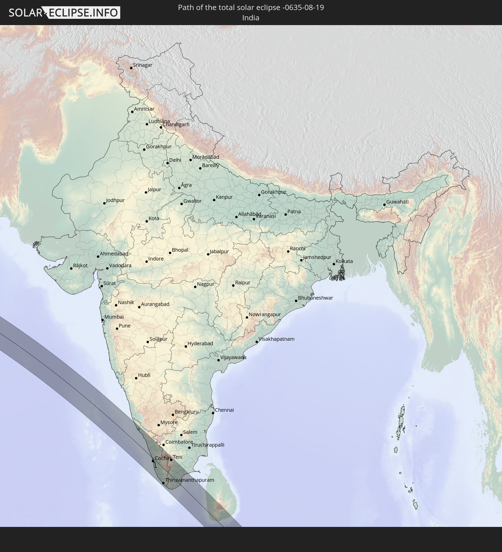 India
India
 Sri Lanka
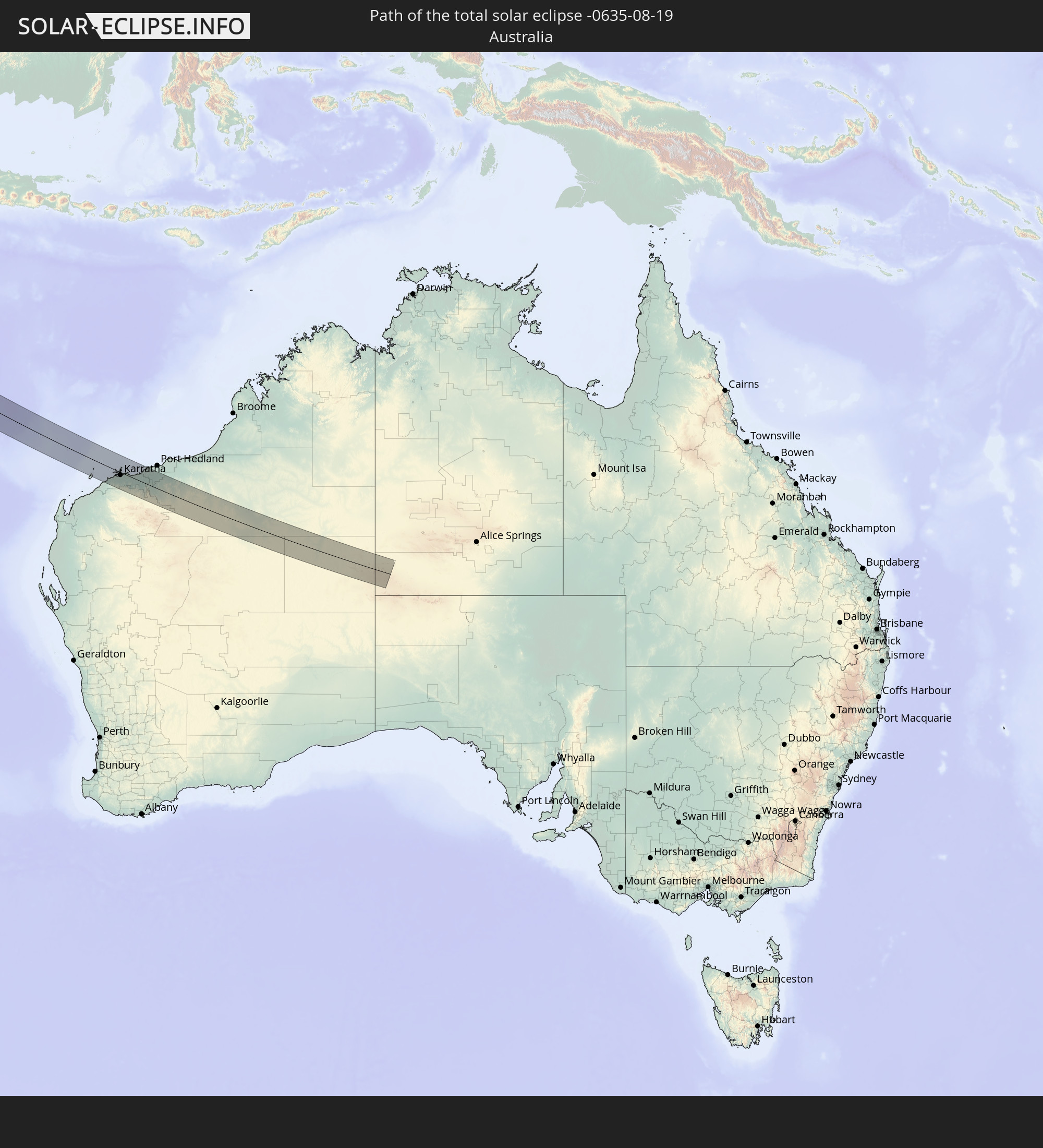 Australia
In den folgenden Ländern ist die Sonnenfinsternis partiell zu sehen
 Russia
 Portugal
 Spain
Spain
 Morocco
 Mali
Mali
 Republic of Ireland
 Algeria
 United Kingdom
 France
 Isle of Man
 Guernsey
 Jersey
 Niger
Niger
 Andorra
 Belgium
 Nigeria
 Netherlands
 Equatorial Guinea
 Luxembourg
 Germany
 Switzerland
 Italy
Italy
 Monaco
 Tunisia
 Denmark
 Cameroon
 Gabon
Gabon
 Libya
Libya
 Liechtenstein
 Austria
 Sweden
 Republic of the Congo
 Angola
 Czechia
 Democratic Republic of the Congo
 San Marino
 Vatican City
 Slovenia
 Chad
Chad
 Croatia
 Poland
 Malta
Malta
 Central African Republic
 Bosnia and Herzegovina
 Hungary
 Slovakia
 Montenegro
 Serbia
 Albania
 Greece
 Romania
 Republic of Macedonia
 Lithuania
 Latvia
 Estonia
 Sudan
Sudan
 Ukraine
 Bulgaria
 Belarus
 Egypt
Egypt
 Turkey
 Moldova
 Rwanda
 Burundi
 Tanzania
 Uganda
 Cyprus
 Ethiopia
 Kenya
Kenya
 State of Palestine
 Israel
 Saudi Arabia
 Jordan
 Lebanon
 Syria
Syria
 Eritrea
 Iraq
Iraq
 Georgia
 Somalia
 Djibouti
 Yemen
Yemen
 Armenia
 Iran
Iran
 Azerbaijan
 Seychelles
 Kazakhstan
 Kuwait
 Bahrain
 Qatar
Qatar
 United Arab Emirates
 Oman
Oman
 Turkmenistan
 Uzbekistan
 Mauritius
 Afghanistan
 Pakistan
 Tajikistan
 India
India
 Kyrgyzstan
 British Indian Ocean Territory
 Maldives
 China
China
 Sri Lanka
 Nepal
Nepal
 Bangladesh
 Bhutan
 Myanmar
 Indonesia
 Cocos Islands
 Thailand
 Malaysia
 Laos
Laos
 Vietnam
 Cambodia
 Singapore
 Christmas Island
 Australia
 Brunei
 Philippines
 East Timor
 Palau
Palau
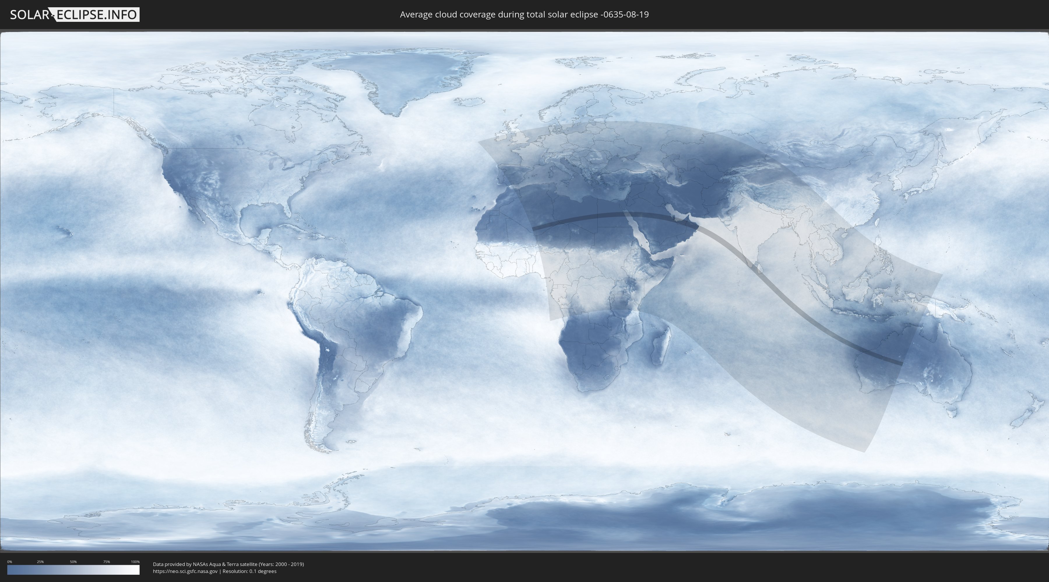
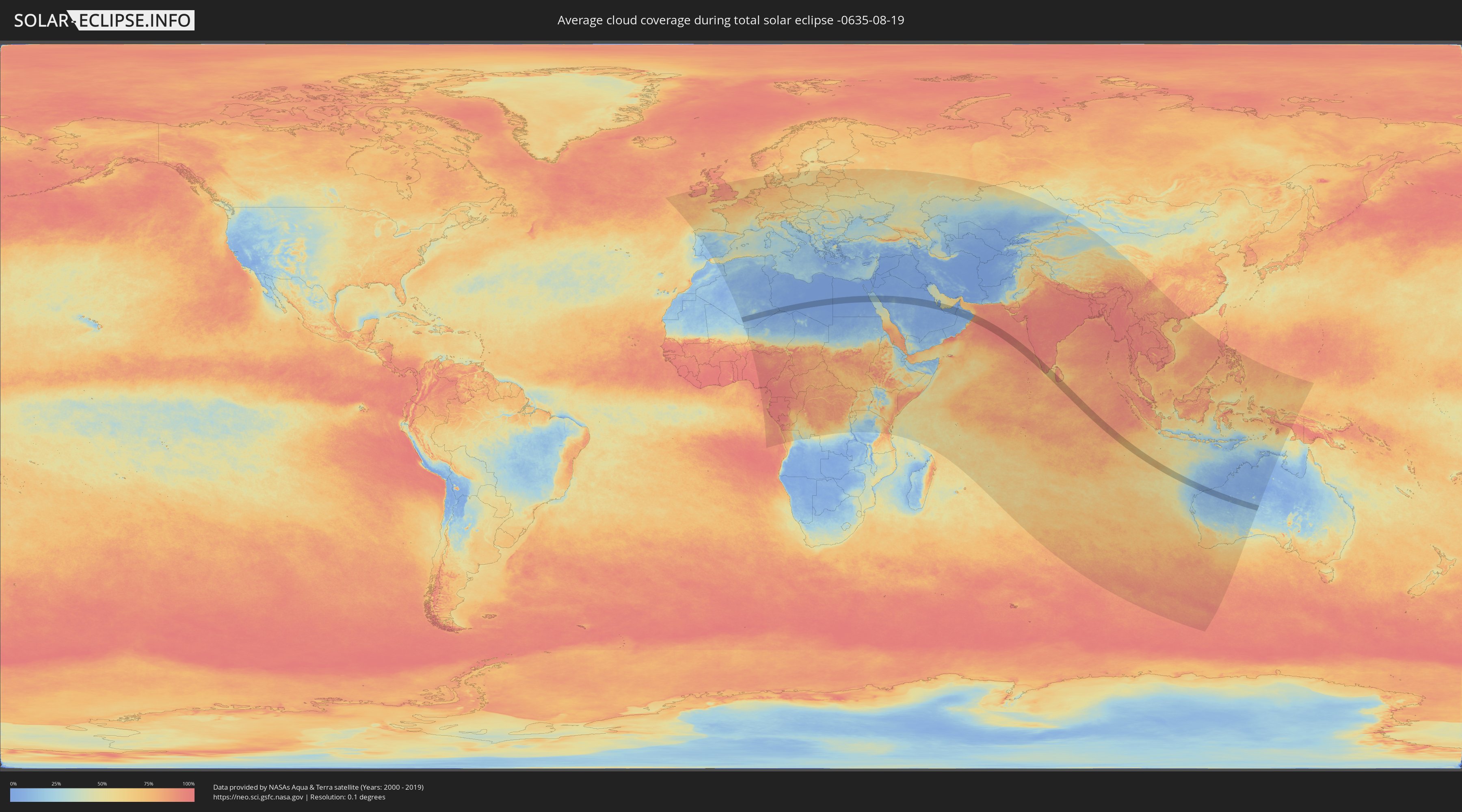
How will be the weather during the total solar eclipse on 08/19/-0635?
Where is the best place to see the total solar eclipse of 08/19/-0635?
The following maps show the average cloud coverage for the day of the total solar eclipse.
With the help of these maps, it is possible to find the place along the eclipse path, which has the best
chance of a cloudless sky.
Nevertheless, you should consider local circumstances and inform about the weather of your chosen
observation site.
The data is provided by NASAs satellites
AQUA and TERRA.
The cloud maps are averaged over a period of 19 years (2000 - 2019).
Detailed country maps
 Algeria
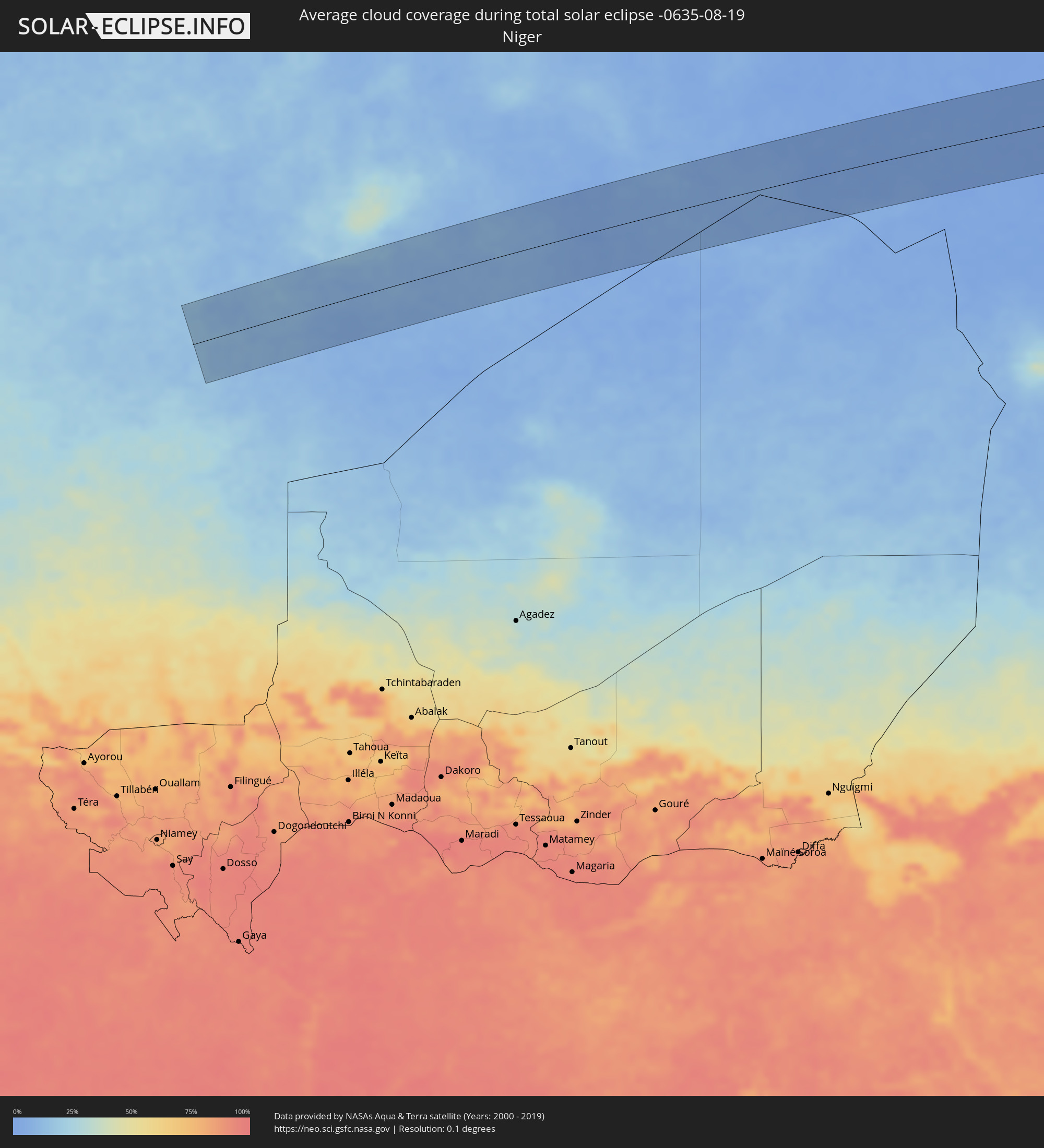 Niger
Niger
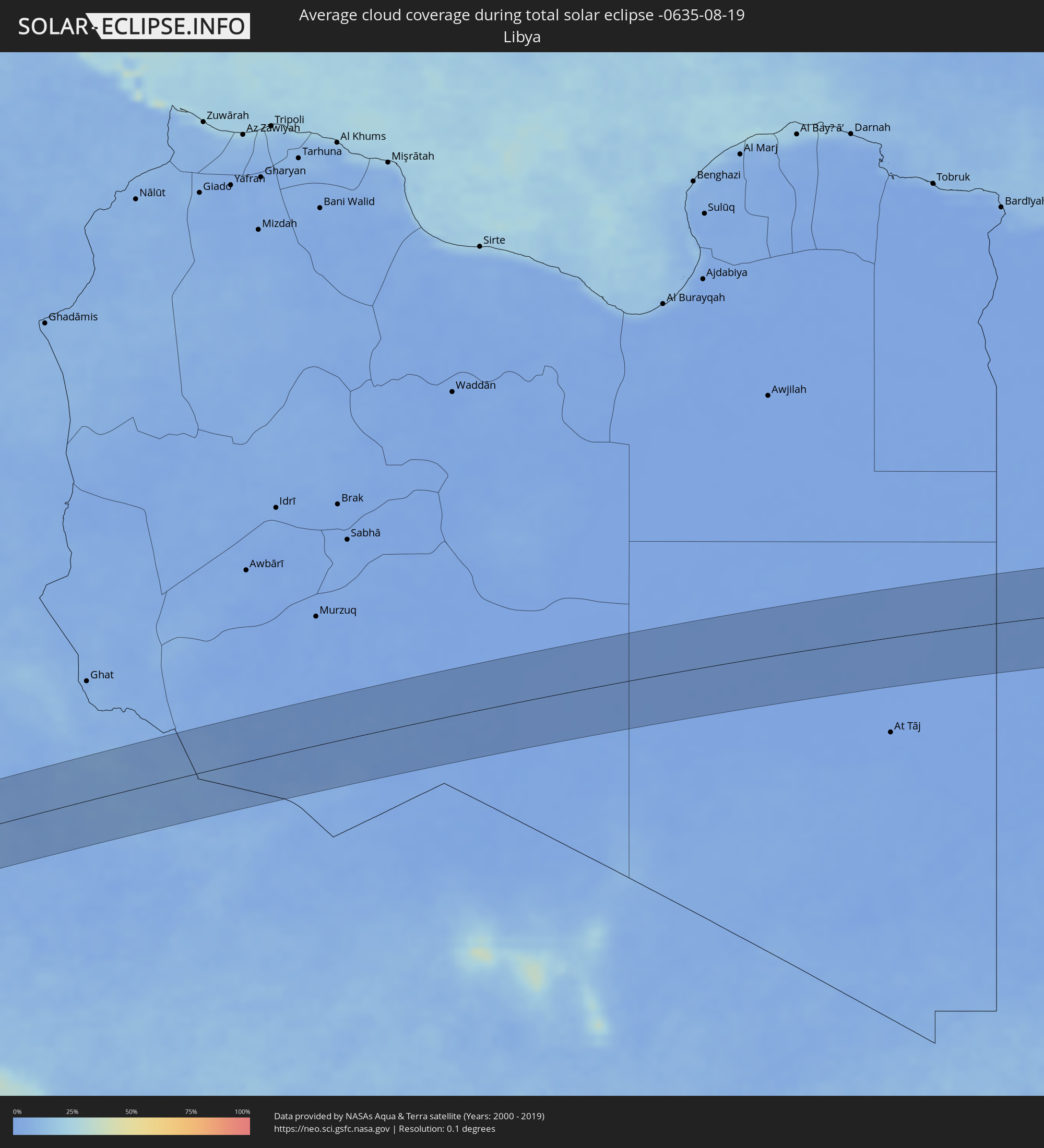 Libya
Libya
 Egypt
Egypt
 Saudi Arabia
 Bahrain
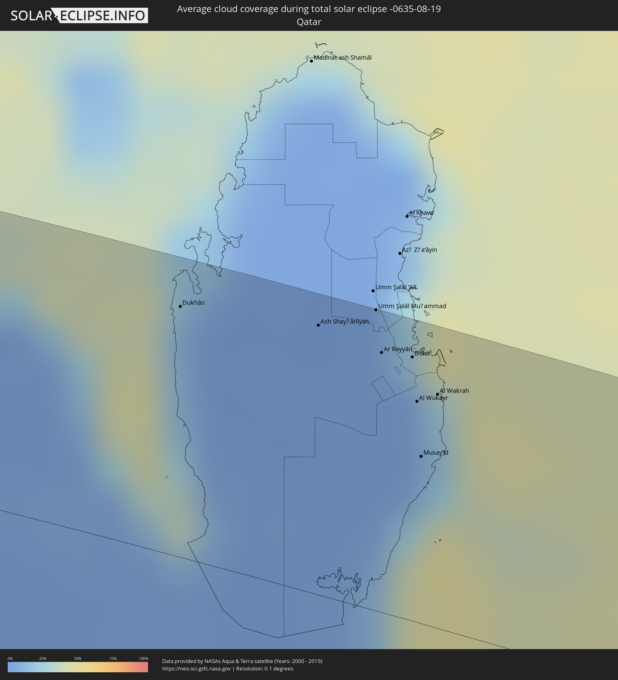 Qatar
Qatar
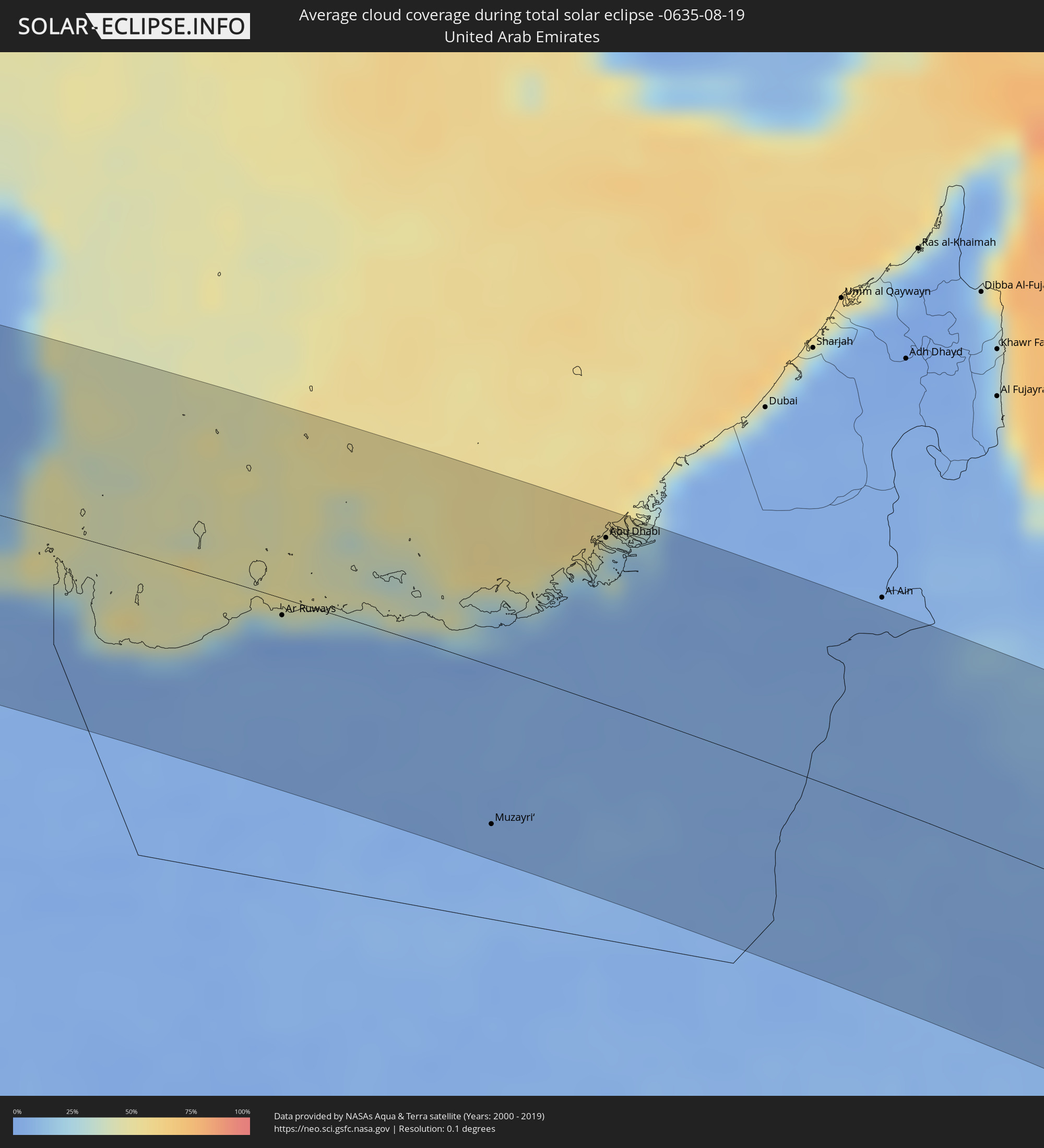 United Arab Emirates
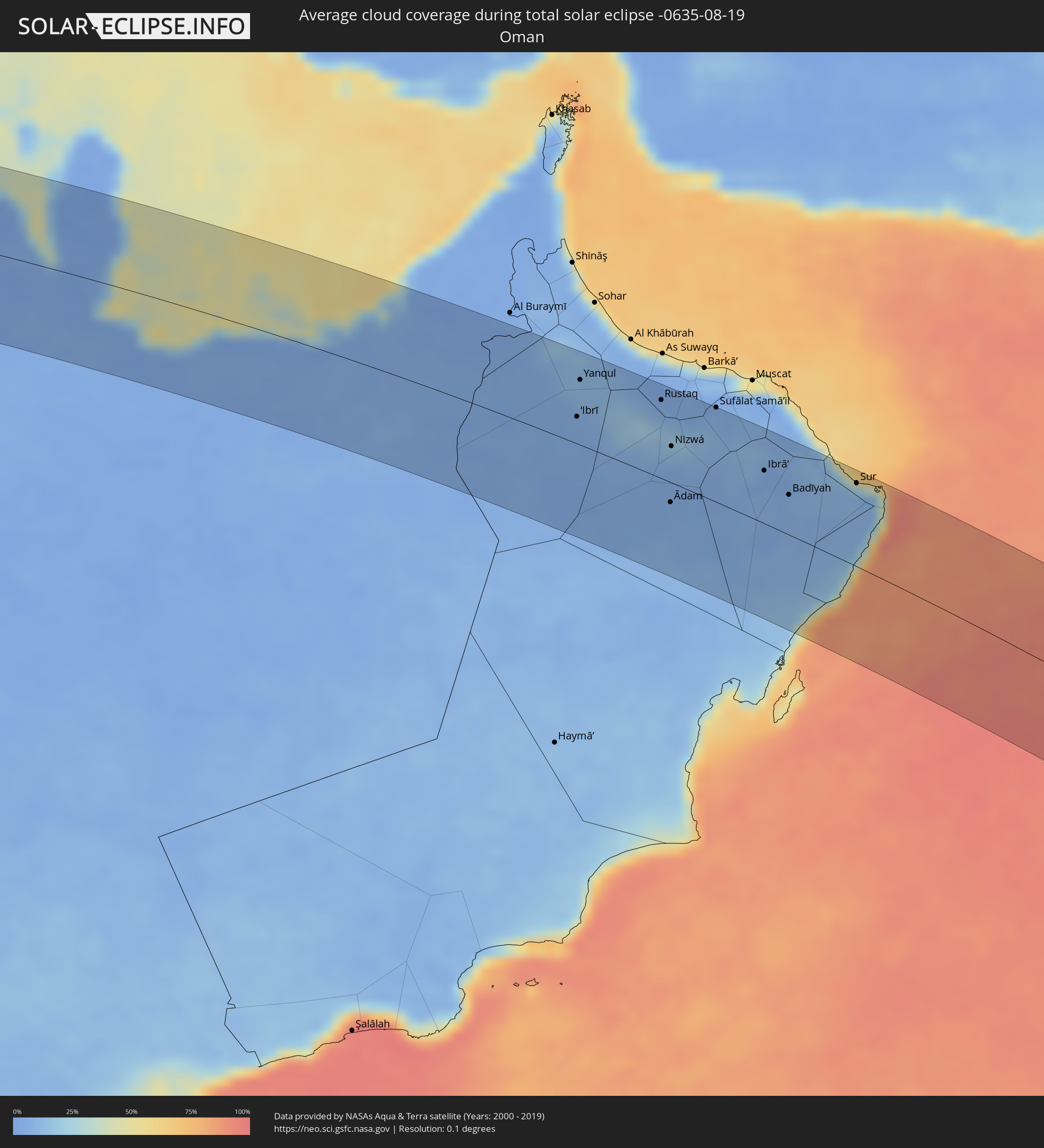 Oman
Oman
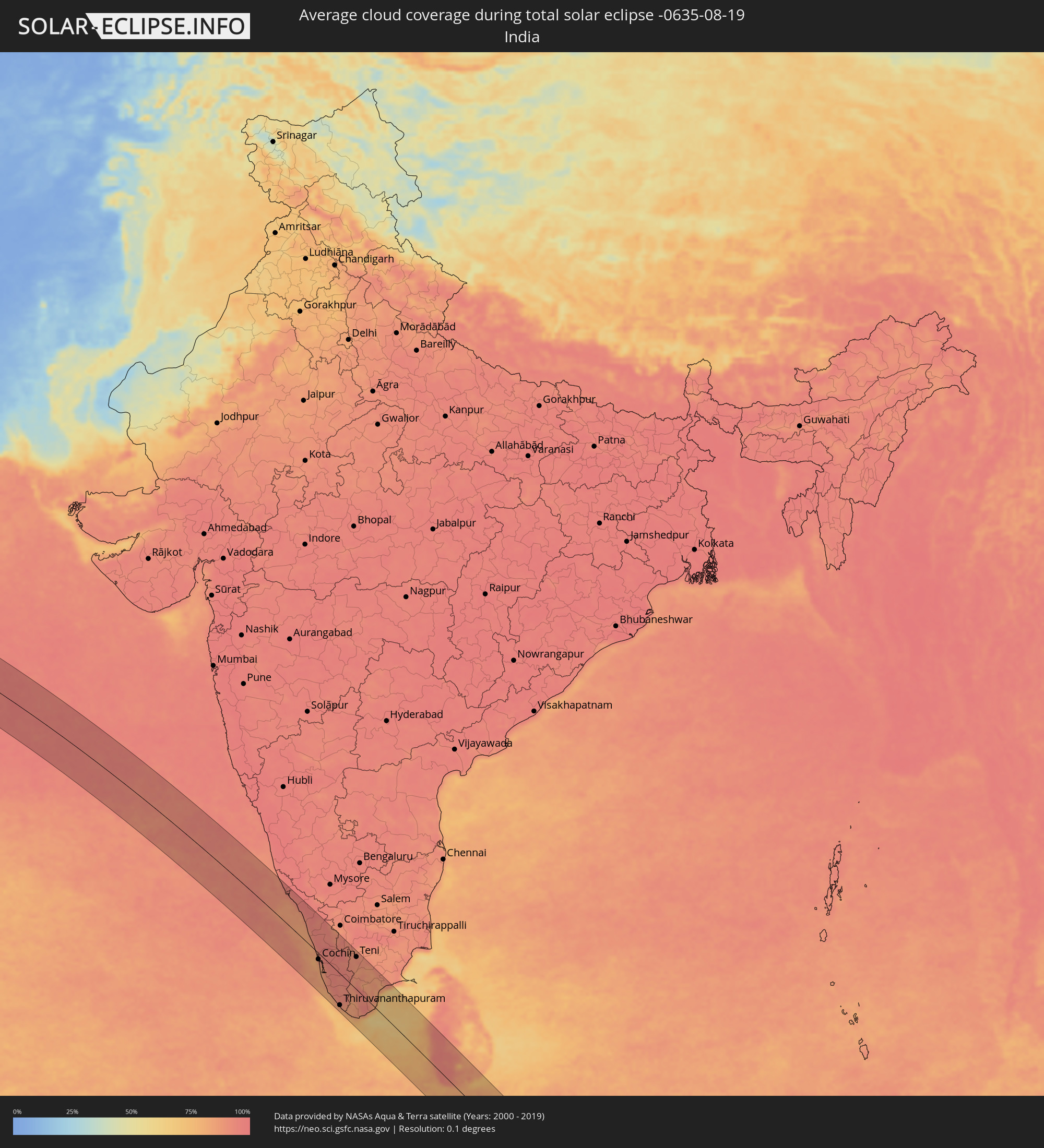 India
India
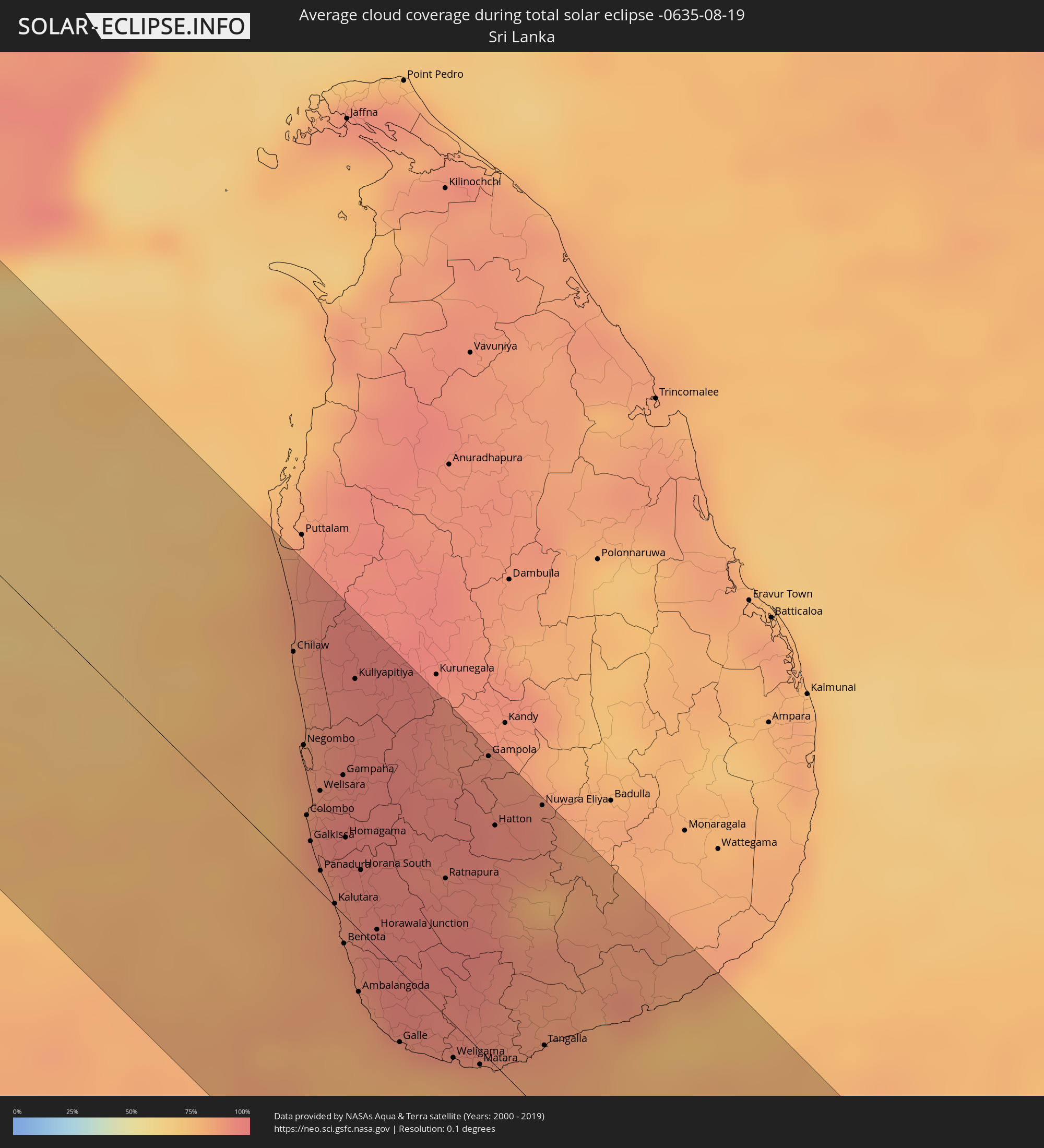 Sri Lanka
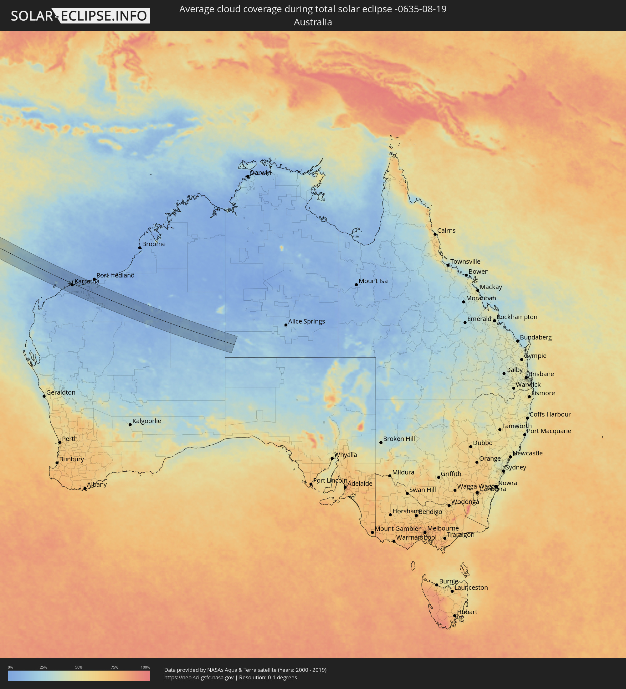 Australia
Cities inside the path of the eclipse
The following table shows all locations with a population of more than 5,000 inside the eclipse path. Cities which have more than 100,000 inhabitants are marked bold. A click at the locations opens a detailed map.
| City | Type | Eclipse duration | Local time of max. eclipse | Distance to central line | Ø Cloud coverage |
|
Abū Tīj, Asyut
|
total | - | 07:40:48 UTC+02:00 | 79 km | 1% |
|
Al Badārī, Asyut
|
total | - | 07:40:53 UTC+02:00 | 73 km | 0% |
|
Juhaynah, Sohag
|
total | - | 07:40:57 UTC+02:00 | 37 km | 1% |
|
Ţahţā, Sohag
|
total | - | 07:40:58 UTC+02:00 | 48 km | 1% |
|
Sohag, Sohag
|
total | - | 07:41:09 UTC+02:00 | 23 km | 1% |
|
Akhmīm, Sohag
|
total | - | 07:41:12 UTC+02:00 | 23 km | 1% |
|
Al Manshāh, Sohag
|
total | - | 07:41:15 UTC+02:00 | 14 km | 1% |
|
Jirjā, Sohag
|
total | - | 07:41:21 UTC+02:00 | 2 km | 2% |
|
Al Balyanā, Sohag
|
total | - | 07:41:27 UTC+02:00 | 14 km | 2% |
|
Farshūţ, Qena
|
total | - | 07:41:37 UTC+02:00 | 35 km | 2% |
|
Naj‘ Ḩammādī, Qena
|
total | - | 07:41:42 UTC+02:00 | 36 km | 2% |
|
Dishnā, Qena
|
total | - | 07:41:57 UTC+02:00 | 28 km | 1% |
|
Luxor, Luxor
|
total | - | 07:42:08 UTC+02:00 | 76 km | 1% |
|
Qinā, Qena
|
total | - | 07:42:13 UTC+02:00 | 25 km | 1% |
|
Kousa, Qena
|
total | - | 07:42:16 UTC+02:00 | 53 km | 2% |
|
Būr Safājah, Red Sea
|
total | - | 07:43:32 UTC+02:00 | 35 km | 4% |
|
Al Quşayr, Red Sea
|
total | - | 07:43:56 UTC+02:00 | 36 km | 11% |
|
Al Wajh, Tabuk
|
total | - | 08:53:23 UTC+03:06 | 20 km | 17% |
|
Al ‘Ulá, Al Madīnah al Munawwarah
|
total | - | 08:55:12 UTC+03:06 | 24 km | 2% |
|
Al Fuwayliq, Al-Qassim
|
total | - | 09:02:44 UTC+03:06 | 48 km | 2% |
|
Ar Rass, Al-Qassim
|
total | - | 09:03:17 UTC+03:06 | 13 km | 3% |
|
Al Bukayrīyah, Al-Qassim
|
total | - | 09:03:27 UTC+03:06 | 20 km | 3% |
|
Buraydah, Al-Qassim
|
total | - | 09:03:52 UTC+03:06 | 44 km | 4% |
|
Unaizah, Al-Qassim
|
total | - | 09:03:59 UTC+03:06 | 18 km | 5% |
|
Al Mithnab, Al-Qassim
|
total | - | 09:04:26 UTC+03:06 | 4 km | 5% |
|
Sājir, Ar Riyāḑ
|
total | - | 09:05:18 UTC+03:06 | 73 km | 5% |
|
Az Zulfi, Ar Riyāḑ
|
total | - | 09:05:12 UTC+03:06 | 53 km | 3% |
|
Al Arţāwīyah, Ar Riyāḑ
|
total | - | 09:05:58 UTC+03:06 | 84 km | 3% |
|
Marāt, Ar Riyāḑ
|
total | - | 09:06:46 UTC+03:06 | 72 km | 6% |
|
Tumayr, Ar Riyāḑ
|
total | - | 09:07:09 UTC+03:06 | 4 km | 6% |
|
Al Muţayrifī, Eastern Province
|
total | - | 09:13:37 UTC+03:06 | 54 km | 5% |
|
Al Hufūf, Eastern Province
|
total | - | 09:13:42 UTC+03:06 | 41 km | 4% |
|
Al Mubarraz, Eastern Province
|
total | - | 09:13:42 UTC+03:06 | 47 km | 4% |
|
Al Qurayn, Eastern Province
|
total | - | 09:13:41 UTC+03:06 | 55 km | 5% |
|
Julayjilah, Eastern Province
|
total | - | 09:13:41 UTC+03:06 | 57 km | 5% |
|
Al Baţţālīyah, Eastern Province
|
total | - | 09:13:47 UTC+03:06 | 50 km | 4% |
|
Al Jubayl, Eastern Province
|
total | - | 09:13:50 UTC+03:06 | 47 km | 4% |
|
Al Qārah, Eastern Province
|
total | - | 09:13:51 UTC+03:06 | 49 km | 4% |
|
Al Munayzilah, Eastern Province
|
total | - | 09:13:52 UTC+03:06 | 46 km | 4% |
|
Al Jafr, Eastern Province
|
total | - | 09:13:59 UTC+03:06 | 46 km | 4% |
|
Aţ Ţaraf, Eastern Province
|
total | - | 09:13:59 UTC+03:06 | 45 km | 4% |
|
Al Markaz, Eastern Province
|
total | - | 09:13:59 UTC+03:06 | 49 km | 4% |
|
Dukhān, Baladīyat ar Rayyān
|
total | - | 09:35:08 UTC+03:26 | 78 km | 14% |
|
Ash Shayḩānīyah, Baladīyat ar Rayyān
|
total | - | 09:35:58 UTC+03:26 | 84 km | 2% |
|
Umm Şalāl Muḩammad, Baladīyat Umm Şalāl
|
total | - | 09:36:17 UTC+03:26 | 93 km | 4% |
|
Ar Rayyān, Baladīyat ar Rayyān
|
total | - | 09:36:24 UTC+03:26 | 81 km | 3% |
|
Doha, Baladīyat ad Dawḩah
|
total | - | 09:36:35 UTC+03:26 | 82 km | 6% |
|
Al Wukayr, Al Wakrah
|
total | - | 09:36:43 UTC+03:26 | 68 km | 5% |
|
Musay‘īd, Al Wakrah
|
total | - | 09:36:51 UTC+03:26 | 52 km | 25% |
|
Al Wakrah, Al Wakrah
|
total | - | 09:36:49 UTC+03:26 | 72 km | 20% |
|
Ar Ruways, Abu Dhabi
|
total | - | 09:54:50 UTC+03:41 | 8 km | 4% |
|
Muzayri‘, Abu Dhabi
|
total | - | 09:57:44 UTC+03:41 | 77 km | 4% |
|
Abu Dhabi, Abu Dhabi
|
total | - | 09:57:43 UTC+03:41 | 81 km | 21% |
|
‘Ibrī, Az̧ Z̧āhirah
|
total | - | 10:03:11 UTC+03:41 | 28 km | 5% |
|
Yanqul, Az̧ Z̧āhirah
|
total | - | 10:02:53 UTC+03:41 | 67 km | 11% |
|
Bahlā’, Muḩāfaz̧at ad Dākhilīyah
|
total | - | 10:05:03 UTC+03:41 | 32 km | 12% |
|
Rustaq, Al Batinah South Governorate
|
total | - | 10:04:53 UTC+03:41 | 80 km | 7% |
|
Ādam, Muḩāfaz̧at ad Dākhilīyah
|
total | - | 10:06:10 UTC+03:41 | 20 km | 6% |
|
Bayt al ‘Awābī, Al Batinah South Governorate
|
total | - | 10:05:10 UTC+03:41 | 75 km | 10% |
|
Nizwá, Muḩāfaz̧at ad Dākhilīyah
|
total | - | 10:05:35 UTC+03:41 | 37 km | 10% |
|
Izkī, Muḩāfaz̧at ad Dākhilīyah
|
total | - | 10:06:04 UTC+03:41 | 47 km | 9% |
|
Sufālat Samā’il, Muḩāfaz̧at ad Dākhilīyah
|
total | - | 10:06:10 UTC+03:41 | 96 km | 7% |
|
Ibrā’, Ash Sharqiyah North Governorate
|
total | - | 10:07:56 UTC+03:41 | 53 km | 6% |
|
Al Qābil, Ash Sharqiyah North Governorate
|
total | - | 10:08:25 UTC+03:41 | 48 km | 5% |
|
Badīyah, Ash Sharqiyah North Governorate
|
total | - | 10:08:46 UTC+03:41 | 40 km | 8% |
|
Sur, Ash Sharqiyah South Governorate
|
total | - | 10:10:10 UTC+03:41 | 84 km | 20% |
|
Kānnangād, Kerala
|
total | - | 12:40:34 UTC+05:21 | 91 km | 89% |
|
Payyannūr, Kerala
|
total | - | 12:41:10 UTC+05:21 | 81 km | 90% |
|
Talipparamba, Kerala
|
total | - | 12:41:35 UTC+05:21 | 88 km | 90% |
|
Tellicherry, Kerala
|
total | - | 12:42:25 UTC+05:21 | 74 km | 86% |
|
Badagara, Kerala
|
total | - | 12:42:53 UTC+05:21 | 68 km | 84% |
|
Kozhikode, Kerala
|
total | - | 12:43:58 UTC+05:21 | 55 km | 83% |
|
Ponnāni, Kerala
|
total | - | 12:45:11 UTC+05:21 | 26 km | 82% |
|
Manjeri, Kerala
|
total | - | 12:44:54 UTC+05:21 | 69 km | 95% |
|
Trichūr, Kerala
|
total | - | 12:46:15 UTC+05:21 | 28 km | 92% |
|
Cochin, Kerala
|
total | - | 12:47:27 UTC+05:21 | 16 km | 85% |
|
Alleppey, Kerala
|
total | - | 12:48:27 UTC+05:21 | 47 km | 83% |
|
Kollam, Kerala
|
total | - | 12:50:09 UTC+05:21 | 76 km | 80% |
|
Palakkad, Kerala
|
total | - | 12:46:39 UTC+05:21 | 82 km | 92% |
|
Thiruvananthapuram, Kerala
|
total | - | 12:51:38 UTC+05:21 | 80 km | 82% |
|
Valparai, Tamil Nadu
|
total | - | 12:48:06 UTC+05:21 | 68 km | 96% |
|
Neyyāttinkara, Kerala
|
total | - | 12:52:04 UTC+05:21 | 77 km | 79% |
|
Kadayanallur, Tamil Nadu
|
total | - | 12:51:17 UTC+05:21 | 3 km | 88% |
|
Nāgercoil, Tamil Nadu
|
total | - | 12:53:11 UTC+05:21 | 68 km | 79% |
|
Teni, Tamil Nadu
|
total | - | 12:49:45 UTC+05:21 | 83 km | 90% |
|
Rajapalaiyam, Tamil Nadu
|
total | - | 12:50:58 UTC+05:21 | 43 km | 90% |
|
Tirunelveli, Tamil Nadu
|
total | - | 12:52:38 UTC+05:21 | 5 km | 92% |
|
Sivakasi, Tamil Nadu
|
total | - | 12:51:27 UTC+05:21 | 62 km | 86% |
|
Kovilpatti, Tamil Nadu
|
total | - | 12:52:08 UTC+05:21 | 45 km | 85% |
|
Virudunagar, Tamil Nadu
|
total | - | 12:51:31 UTC+05:21 | 85 km | 84% |
|
Aruppukkottai, Tamil Nadu
|
total | - | 12:51:55 UTC+05:21 | 89 km | 85% |
|
Chilaw, North Western
|
total | - | 12:57:15 UTC+05:19 | 66 km | 82% |
|
Negombo, Western
|
total | - | 12:58:02 UTC+05:19 | 41 km | 83% |
|
Colombo, Western
|
total | - | 12:58:35 UTC+05:19 | 20 km | 80% |
|
Moratuwa, Western
|
total | - | 12:58:56 UTC+05:19 | 10 km | 86% |
|
Peliyagoda, Western
|
total | - | 12:58:34 UTC+05:19 | 25 km | 91% |
|
Wattala, Western
|
total | - | 12:58:34 UTC+05:19 | 27 km | 91% |
|
Ja Ela, Western
|
total | - | 12:58:23 UTC+05:19 | 34 km | 88% |
|
Kandana, Western
|
total | - | 12:58:26 UTC+05:19 | 32 km | 91% |
|
Panadura, Western
|
total | - | 12:59:06 UTC+05:19 | 7 km | 83% |
|
Kelaniya, Western
|
total | - | 12:58:40 UTC+05:19 | 27 km | 91% |
|
Mulleriyawa, Western
|
total | - | 12:58:44 UTC+05:19 | 26 km | 91% |
|
Kalutara, Western
|
total | - | 12:59:27 UTC+05:19 | 1 km | 88% |
|
Beruwala, Western
|
total | - | 12:59:41 UTC+05:19 | 6 km | 87% |
|
Bentota, Southern
|
total | - | 12:59:49 UTC+05:19 | 9 km | 84% |
|
Homagama, Western
|
total | - | 12:59:02 UTC+05:19 | 25 km | 93% |
|
Ambalangoda, Southern
|
total | - | 13:00:17 UTC+05:19 | 19 km | 82% |
|
Hanwella Ihala, Western
|
total | - | 12:59:05 UTC+05:19 | 36 km | 95% |
|
Galle, Southern
|
total | - | 13:00:58 UTC+05:19 | 22 km | 79% |
|
Ratnapura, Sabaragamuwa
|
total | - | 13:00:04 UTC+05:19 | 43 km | 93% |
|
Weligama, Southern
|
total | - | 13:01:28 UTC+05:19 | 11 km | 80% |
|
Matara, Southern
|
total | - | 13:01:43 UTC+05:19 | 4 km | 79% |
|
Gampola, Central
|
total | - | 12:59:28 UTC+05:19 | 94 km | 90% |
|
Hatton, Central
|
total | - | 13:00:02 UTC+05:19 | 75 km | 93% |
|
Nuwara Eliya, Central
|
total | - | 13:00:14 UTC+05:19 | 96 km | 89% |
|
Tangalla, Southern
|
total | - | 13:02:02 UTC+05:19 | 22 km | 83% |
|
Karratha, Western Australia
|
total | - | 16:51:14 UTC+08:00 | 13 km | 7% |