Total solar eclipse of 04/26/-0638
| Day of week: | Saturday |
| Maximum duration of eclipse: | 05m26s |
| Maximum width of eclipse path: | 293 km |
| Saros cycle: | 57 |
| Coverage: | 100% |
| Magnitude: | 1.0768 |
| Gamma: | 0.5412 |
Wo kann man die Sonnenfinsternis vom 04/26/-0638 sehen?

Die Sonnenfinsternis am 04/26/-0638 kann man in 91 Ländern als partielle Sonnenfinsternis beobachten.
Der Finsternispfad verläuft durch 12 Länder. Nur in diesen Ländern ist sie als total Sonnenfinsternis zu sehen.
In den folgenden Ländern ist die Sonnenfinsternis total zu sehen
 Russia
 United States
 Canada
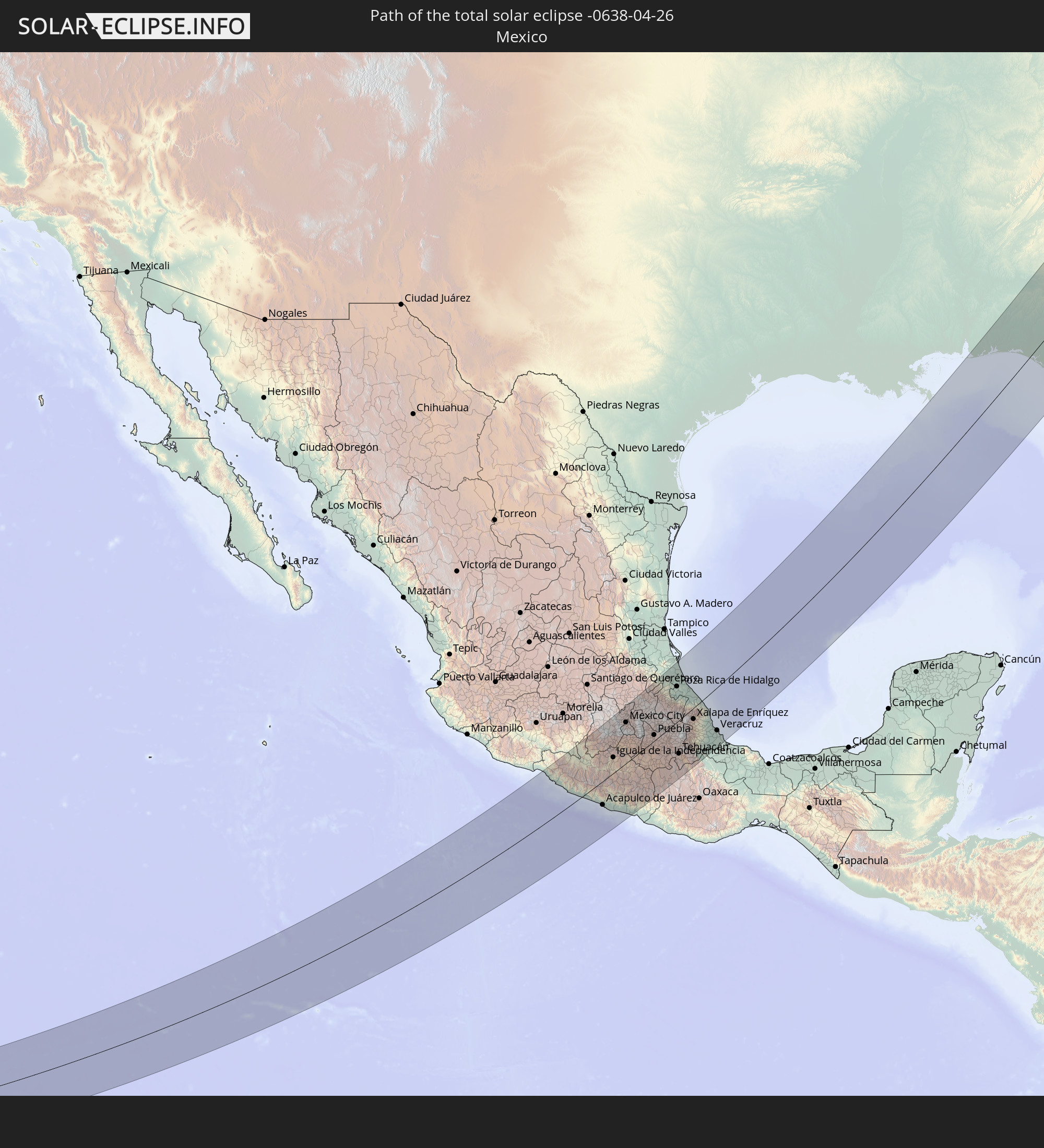 Mexico
 United Kingdom
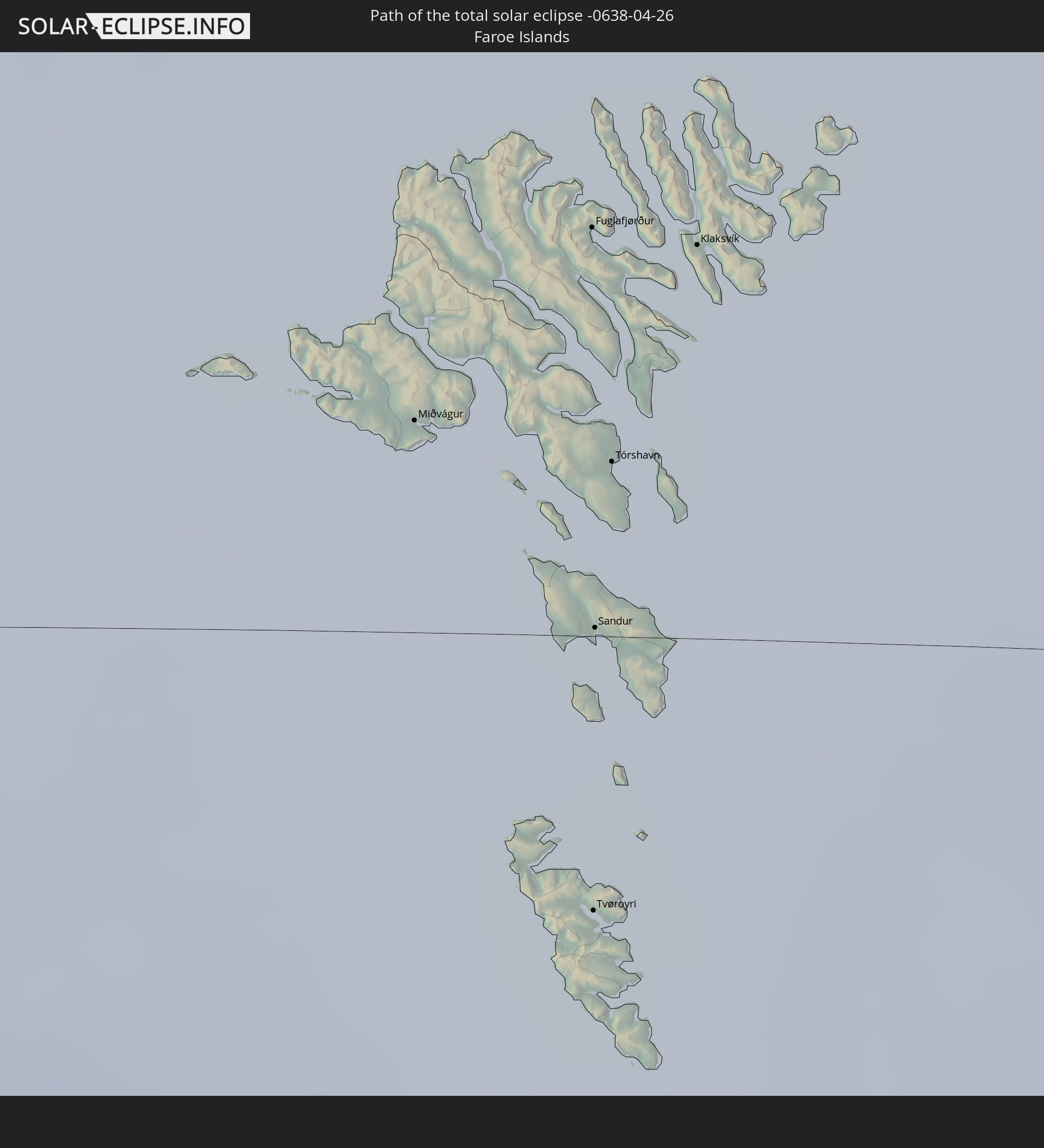 Faroe Islands
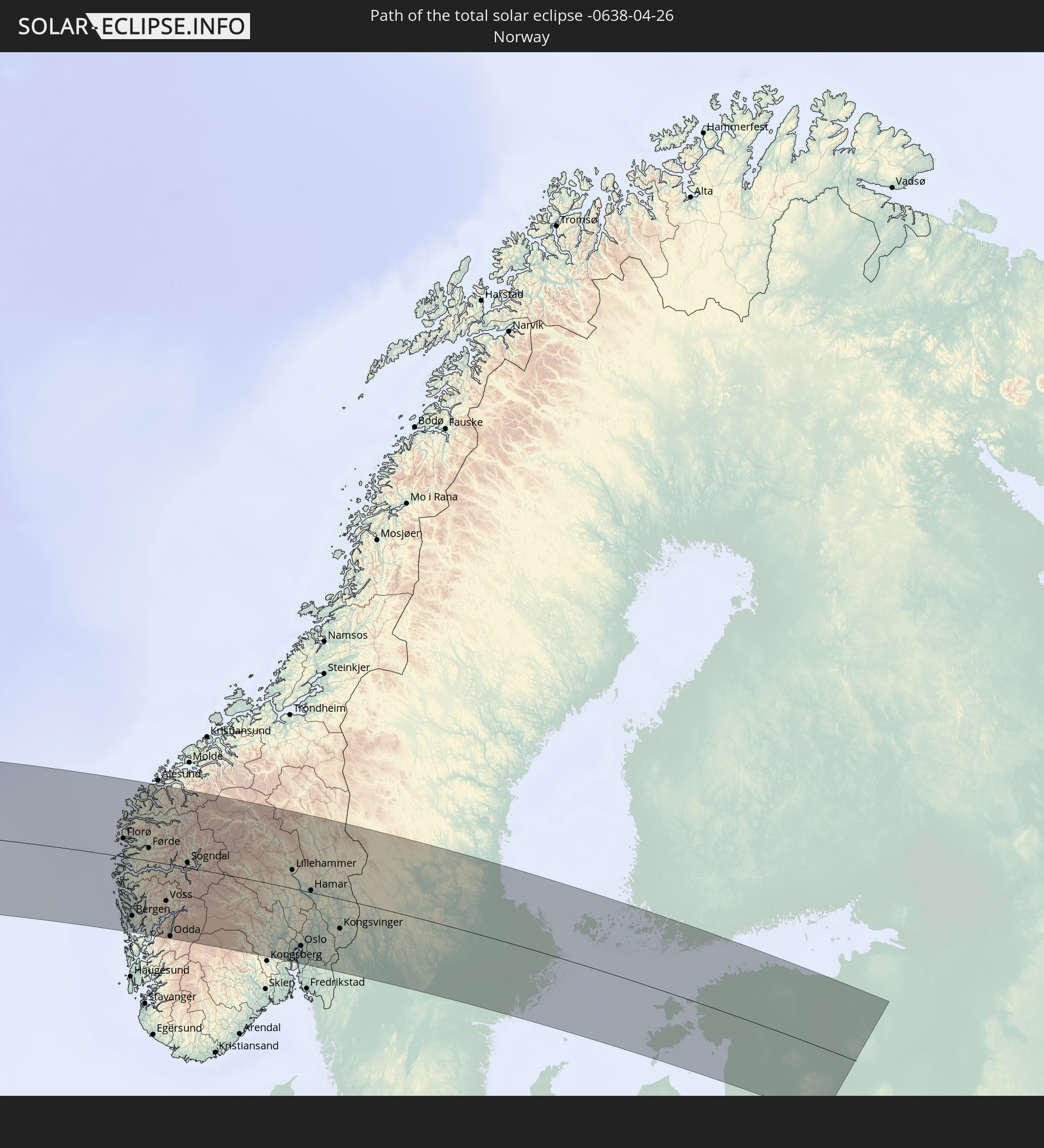 Norway
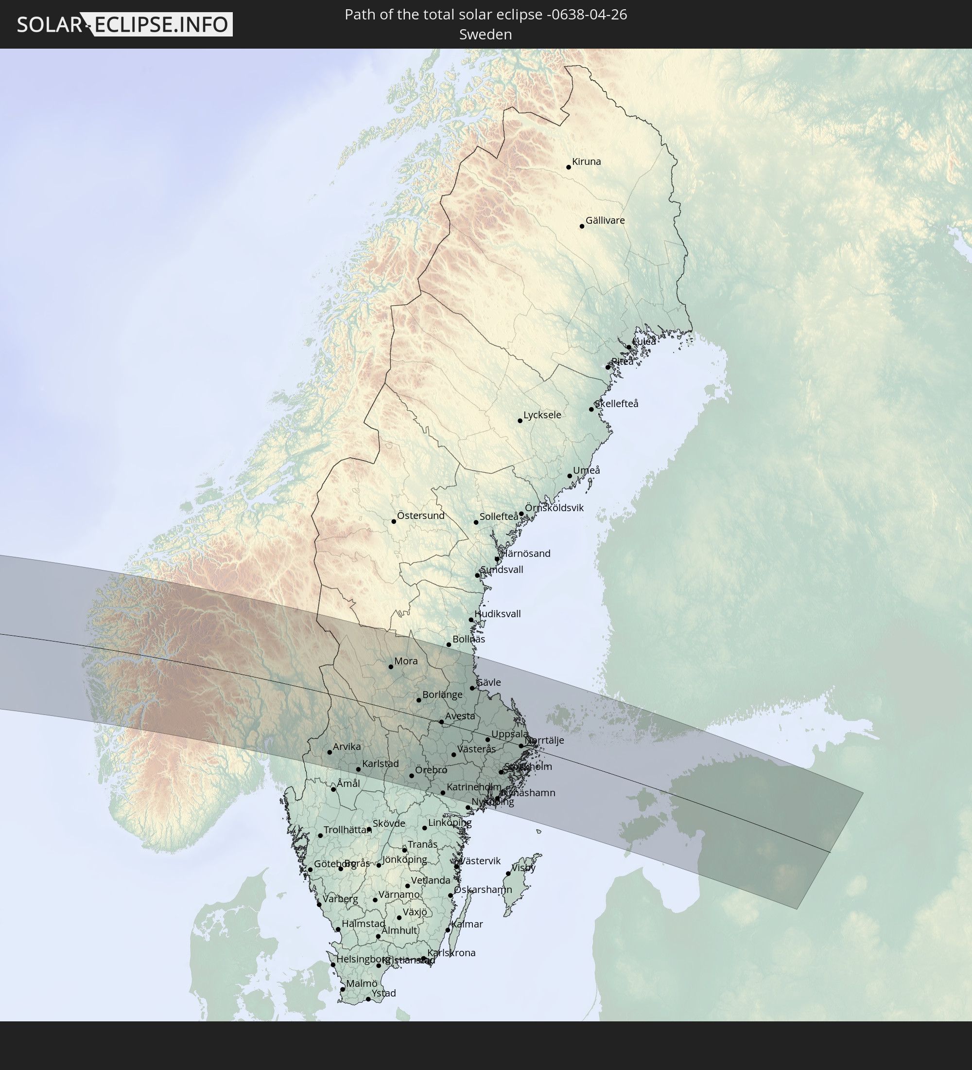 Sweden
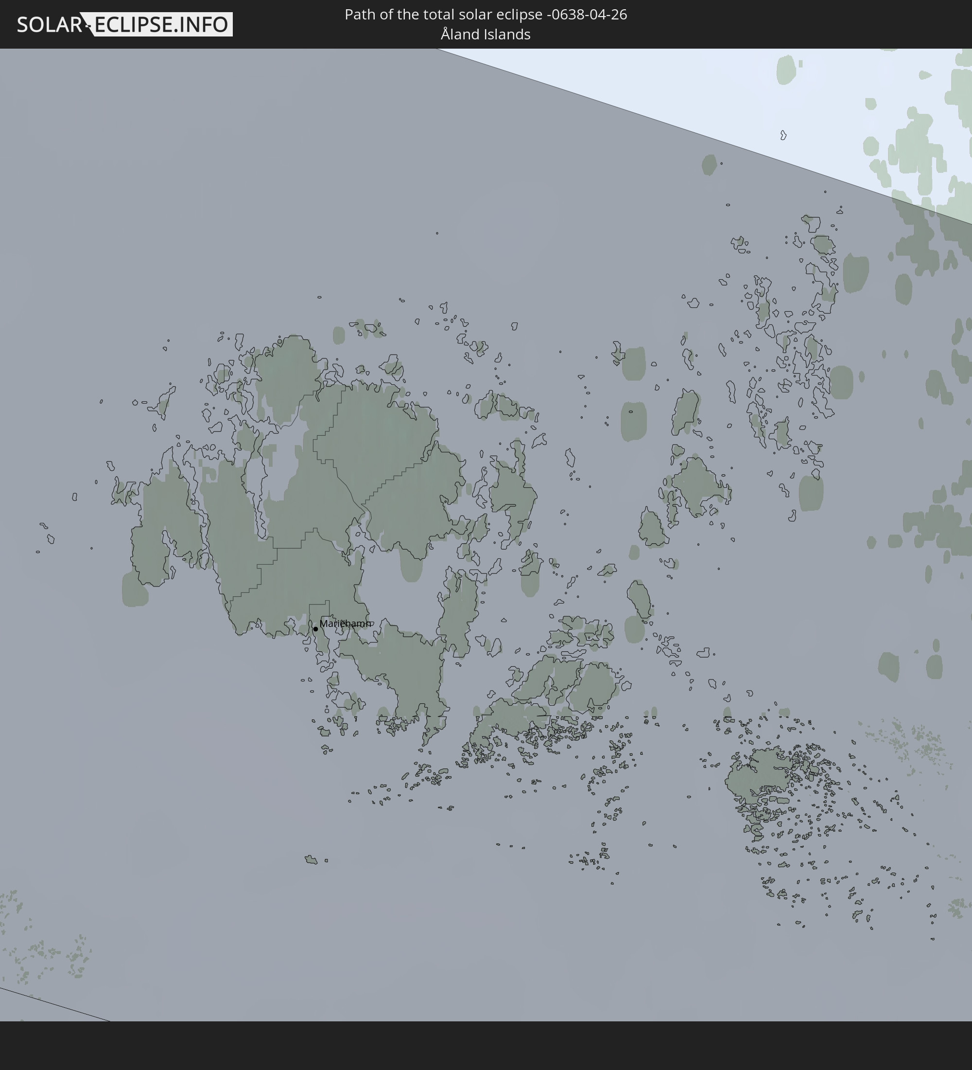 Åland Islands
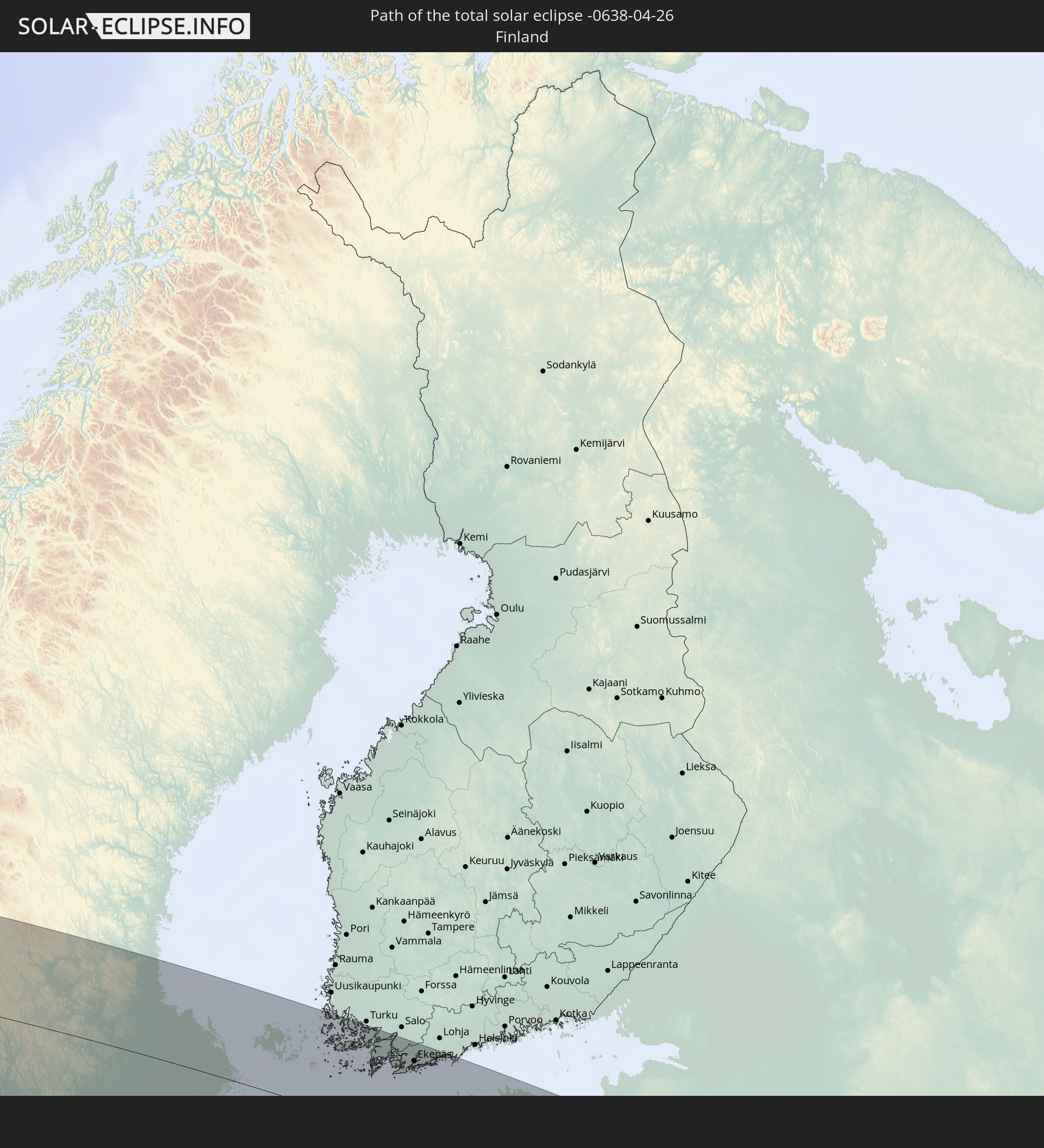 Finland
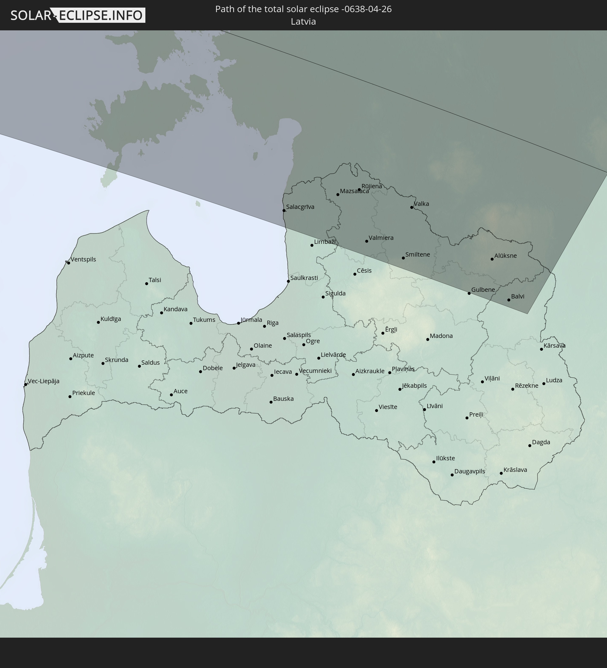 Latvia
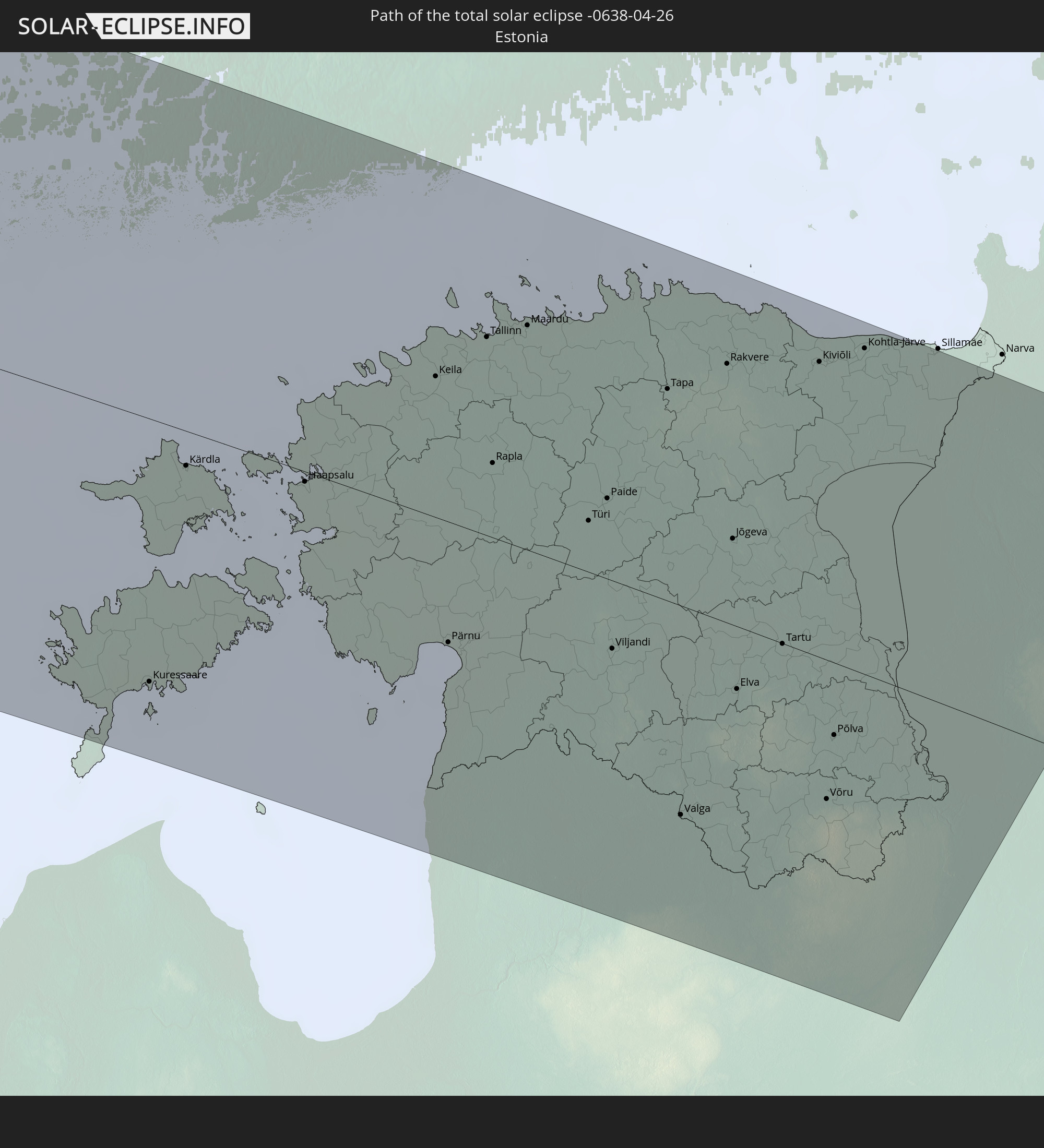 Estonia
In den folgenden Ländern ist die Sonnenfinsternis partiell zu sehen
 Russia
 United States
 United States Minor Outlying Islands
 Canada
 Mexico
 Greenland
 Guatemala
 Ecuador
 El Salvador
 Honduras
 Belize
 Nicaragua
 Costa Rica
 Cuba
Cuba
 Panama
 Colombia
 Cayman Islands
 Peru
Peru
 The Bahamas
 Jamaica
 Haiti
Haiti
 Brazil
 Venezuela
 Turks and Caicos Islands
 Dominican Republic
 Aruba
Aruba
 Puerto Rico
 United States Virgin Islands
 Bermuda
 British Virgin Islands
 Anguilla
 Collectivity of Saint Martin
 Saint Barthélemy
 Saint Kitts and Nevis
 Antigua and Barbuda
 Montserrat
 Trinidad and Tobago
 Guadeloupe
 Grenada
 Dominica
 Saint Vincent and the Grenadines
 Guyana
 Martinique
 Saint Lucia
 Barbados
 Saint Pierre and Miquelon
 Portugal
 Iceland
 Spain
Spain
 Morocco
 Republic of Ireland
 Svalbard and Jan Mayen
 Algeria
 United Kingdom
 Faroe Islands
 Gibraltar
 France
 Isle of Man
 Guernsey
 Jersey
 Andorra
 Belgium
 Netherlands
 Norway
 Luxembourg
 Germany
 Switzerland
 Italy
Italy
 Monaco
 Tunisia
 Denmark
 Libya
Libya
 Liechtenstein
 Austria
 Sweden
 Czechia
 San Marino
 Vatican City
 Slovenia
 Croatia
 Poland
 Bosnia and Herzegovina
 Hungary
 Slovakia
 Serbia
 Åland Islands
 Finland
 Lithuania
 Latvia
 Estonia
 Belarus
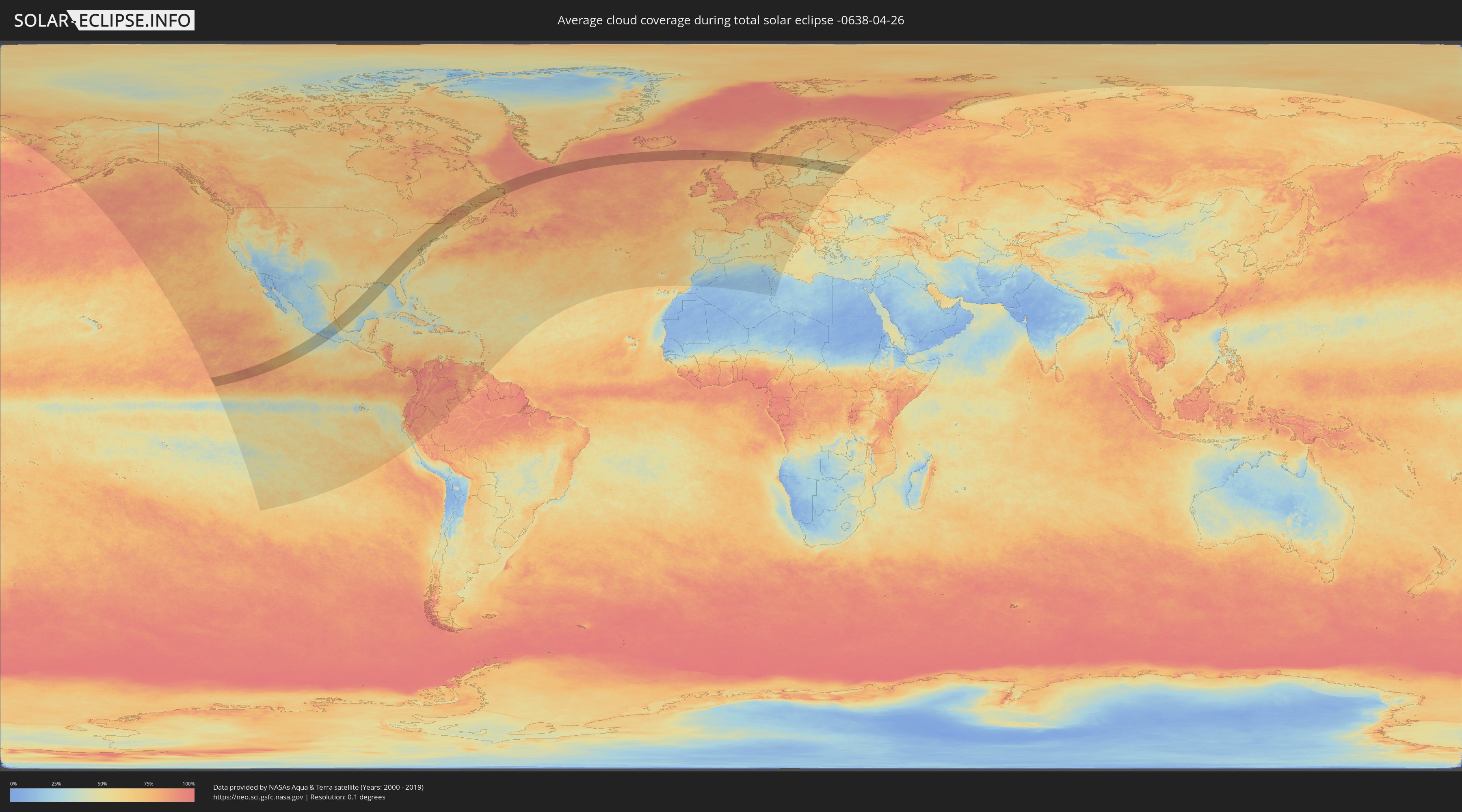
How will be the weather during the total solar eclipse on 04/26/-0638?
Where is the best place to see the total solar eclipse of 04/26/-0638?
The following maps show the average cloud coverage for the day of the total solar eclipse.
With the help of these maps, it is possible to find the place along the eclipse path, which has the best
chance of a cloudless sky.
Nevertheless, you should consider local circumstances and inform about the weather of your chosen
observation site.
The data is provided by NASAs satellites
AQUA and TERRA.
The cloud maps are averaged over a period of 19 years (2000 - 2019).

Detailed country maps
 Russia
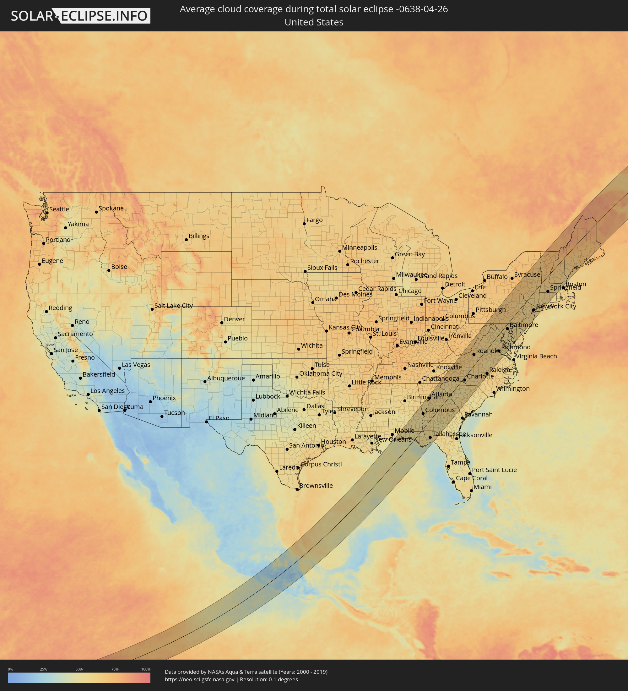 United States
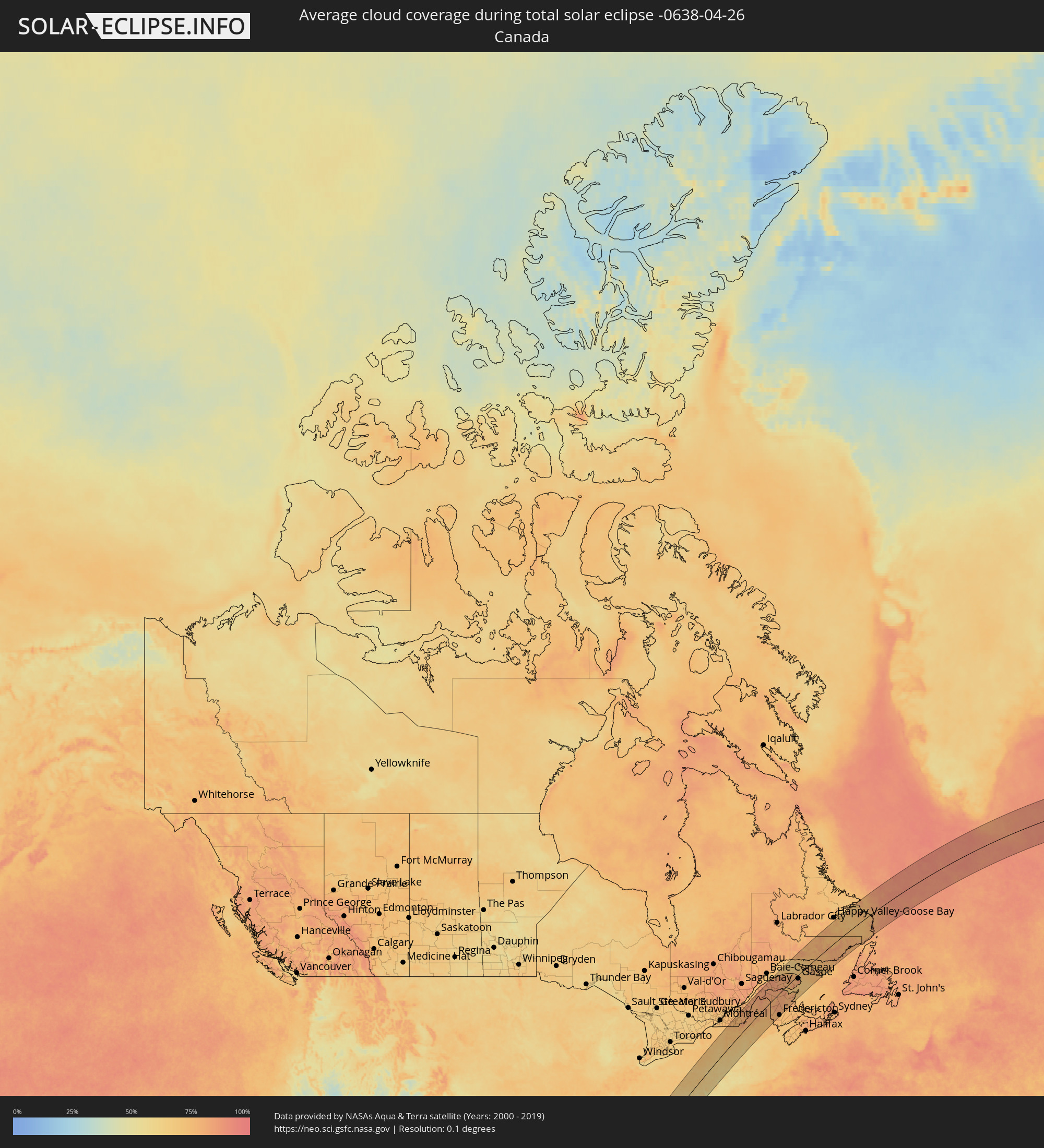 Canada
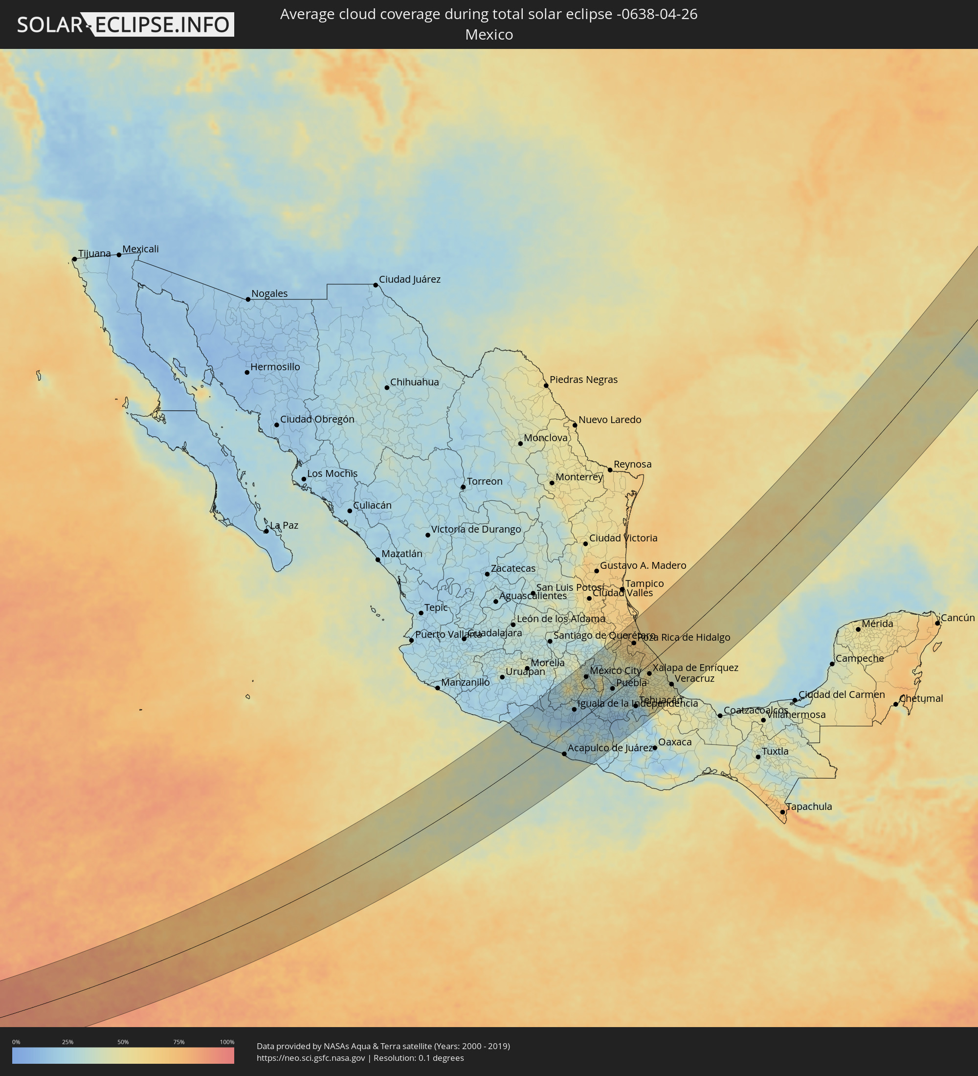 Mexico
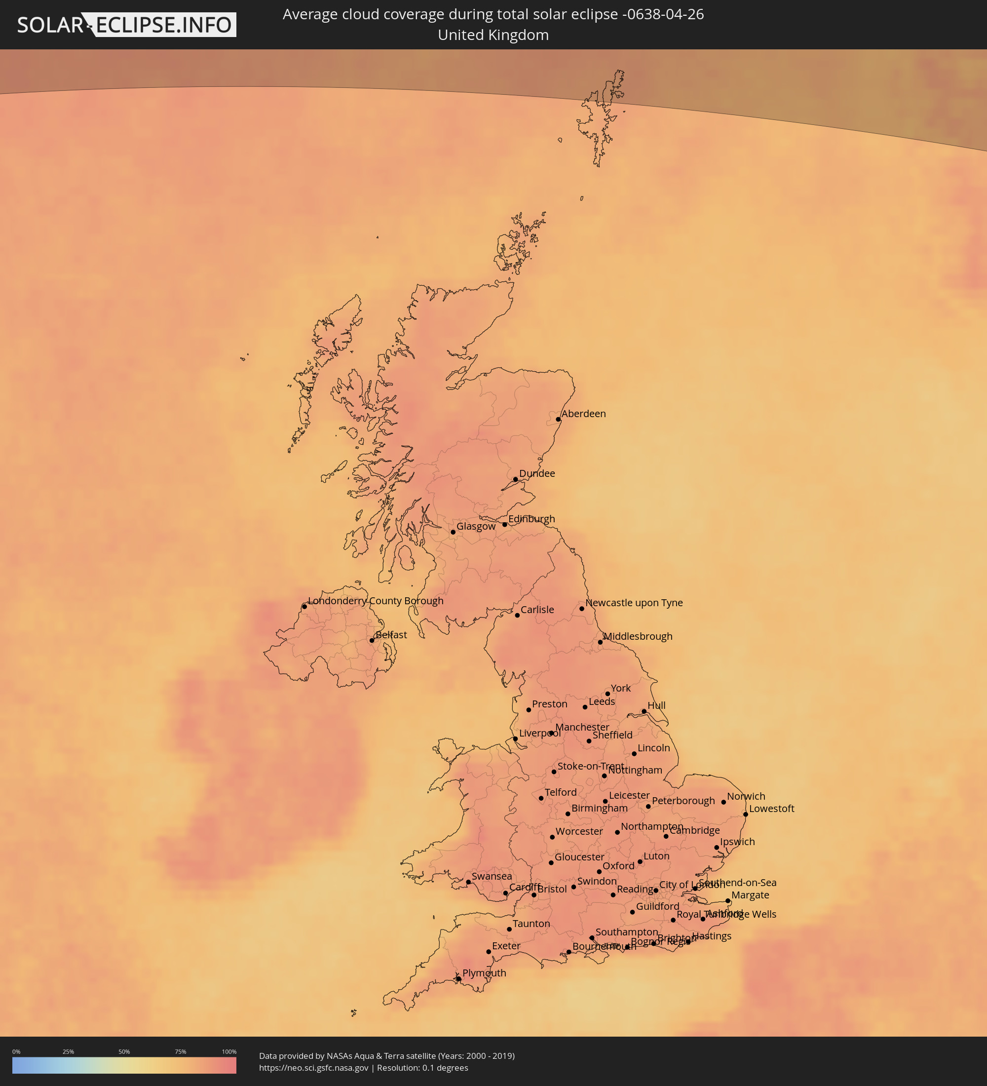 United Kingdom
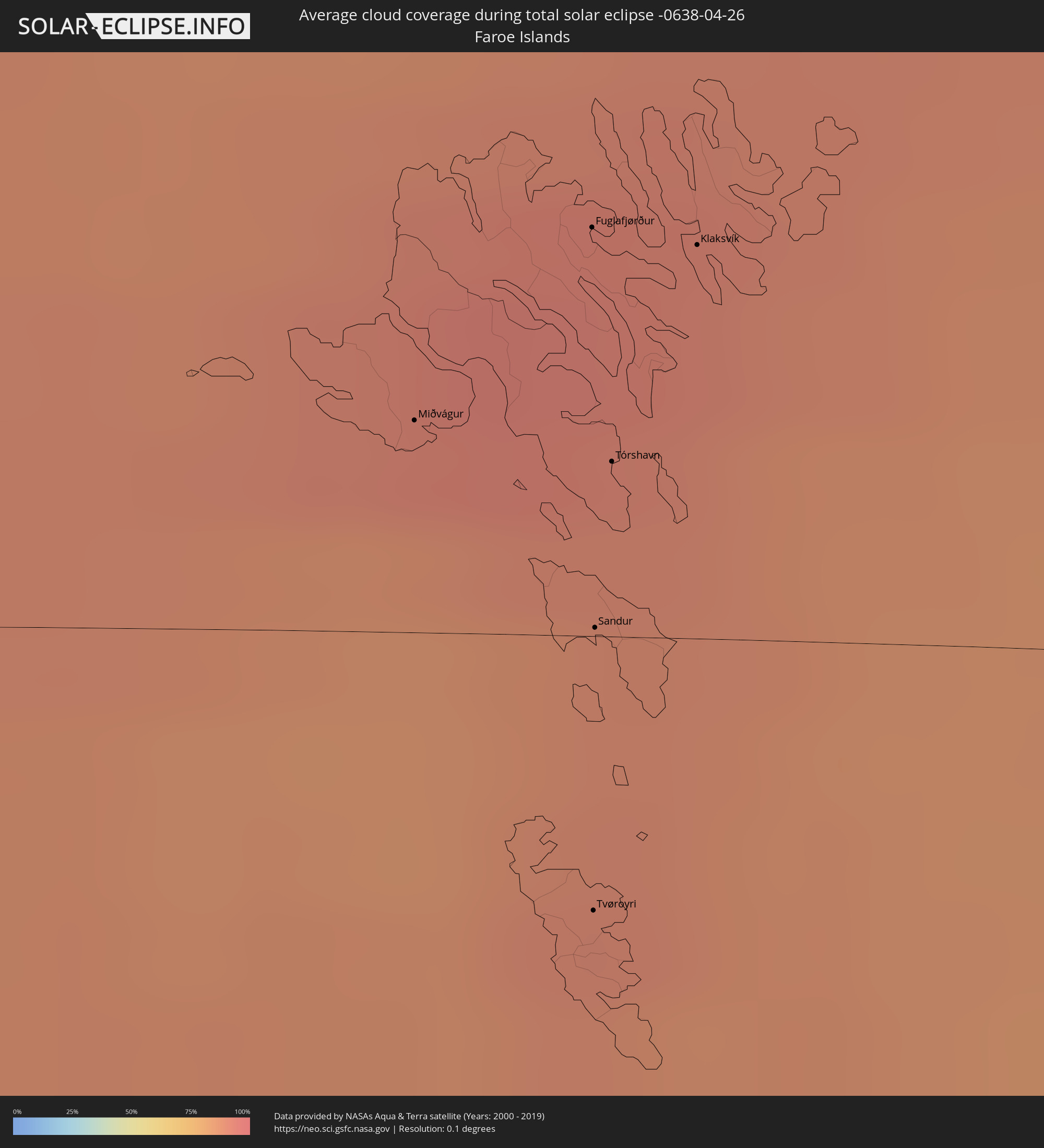 Faroe Islands
 Norway
 Sweden
 Åland Islands
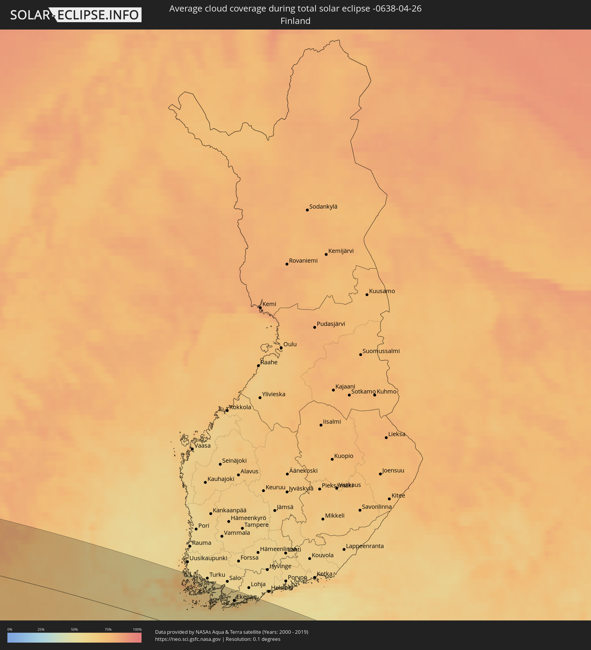 Finland
 Latvia
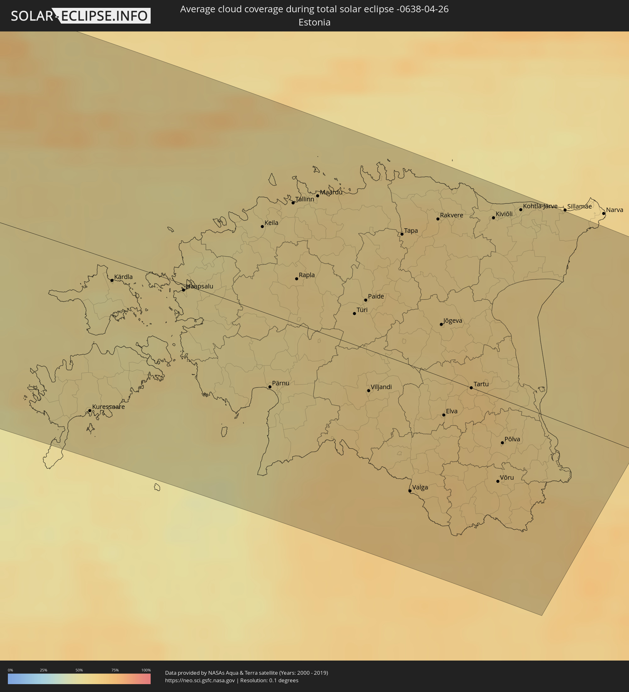 Estonia
Cities inside the path of the eclipse
The following table shows all locations with a population of more than 5,000 inside the eclipse path. Cities which have more than 100,000 inhabitants are marked bold. A click at the locations opens a detailed map.
| City | Type | Eclipse duration | Local time of max. eclipse | Distance to central line | Ø Cloud coverage |
|
Acapulco de Juárez, Guerrero
|
total | - | 08:06:19 UTC-06:36 | 66 km | 39% |
|
Toluca, México
|
total | - | 08:10:34 UTC-06:36 | 133 km | 43% |
|
Chilpancingo, Guerrero
|
total | - | 08:07:43 UTC-06:36 | 29 km | 24% |
|
Ciudad López Mateos, México
|
total | - | 08:11:21 UTC-06:36 | 133 km | 42% |
|
Cuernavaca, Morelos
|
total | - | 08:10:14 UTC-06:36 | 74 km | 28% |
|
Tlalpan, Mexico City
|
total | - | 08:10:55 UTC-06:36 | 102 km | 45% |
|
Mexico City, Mexico City
|
total | - | 08:11:10 UTC-06:36 | 111 km | 35% |
|
Ecatepec, México
|
total | - | 08:11:32 UTC-06:36 | 123 km | 34% |
|
Santa María Chimalhuacán, México
|
total | - | 08:11:17 UTC-06:36 | 98 km | 32% |
|
Cuautla Morelos, Morelos
|
total | - | 08:10:13 UTC-06:36 | 44 km | 24% |
|
San Miguel Xico Viejo, México
|
total | - | 08:11:02 UTC-06:36 | 84 km | 32% |
|
Pachuca de Soto, Hidalgo
|
total | - | 08:12:39 UTC-06:36 | 143 km | 32% |
|
Puebla, Puebla
|
total | - | 08:11:08 UTC-06:36 | 15 km | 29% |
|
Poza Rica de Hidalgo, Veracruz
|
total | - | 08:14:18 UTC-06:36 | 93 km | 63% |
|
Tuxpan de Rodríguez Cano, Veracruz
|
total | - | 08:15:06 UTC-06:36 | 125 km | 59% |
|
Tehuacán, Puebla
|
total | - | 08:10:43 UTC-06:36 | 88 km | 23% |
|
Córdoba, Veracruz
|
total | - | 08:11:48 UTC-06:36 | 83 km | 46% |
|
Xalapa de Enríquez, Veracruz
|
total | - | 08:12:56 UTC-06:36 | 29 km | 47% |
|
Veracruz, Veracruz
|
total | - | 08:12:54 UTC-06:36 | 111 km | 47% |
|
Columbus, Georgia
|
total | - | 10:25:24 UTC-05:00 | 87 km | 58% |
|
Atlanta, Georgia
|
total | - | 10:28:34 UTC-05:00 | 132 km | 61% |
|
Tallahassee, Florida
|
total | - | 10:22:19 UTC-05:00 | 108 km | 51% |
|
Charlotte, North Carolina
|
total | - | 10:35:38 UTC-05:00 | 21 km | 60% |
|
Winston-Salem, North Carolina
|
total | - | 10:38:00 UTC-05:00 | 2 km | 62% |
|
Greensboro, North Carolina
|
total | - | 10:38:31 UTC-05:00 | 36 km | 60% |
|
Durham, North Carolina
|
total | - | 10:39:31 UTC-05:00 | 104 km | 62% |
|
Raleigh, North Carolina
|
total | - | 10:39:26 UTC-05:00 | 138 km | 62% |
|
Richmond, Virginia
|
total | - | 10:44:13 UTC-05:00 | 93 km | 60% |
|
Washington, D.C., Washington, D.C.
|
total | - | 10:47:09 UTC-05:00 | 27 km | 61% |
|
Baltimore, Maryland
|
total | - | 10:48:24 UTC-05:00 | 28 km | 60% |
|
Philadelphia, Pennsylvania
|
total | - | 10:51:26 UTC-05:00 | 76 km | 60% |
|
Paterson, New Jersey
|
total | - | 10:54:22 UTC-05:00 | 71 km | 63% |
|
Staten Island, New York
|
total | - | 10:53:49 UTC-05:00 | 98 km | 59% |
|
New York City, New York
|
total | - | 10:54:15 UTC-05:00 | 96 km | 61% |
|
The Bronx, New York
|
total | - | 10:54:39 UTC-05:00 | 95 km | 62% |
|
Jamaica, New York
|
total | - | 10:54:28 UTC-05:00 | 110 km | 59% |
|
Springfield, Massachusetts
|
total | - | 10:58:23 UTC-05:00 | 84 km | 64% |
|
Lac-Brome, Quebec
|
total | - | 11:03:15 UTC-05:00 | 140 km | 77% |
|
Magog, Quebec
|
total | - | 11:03:48 UTC-05:00 | 122 km | 75% |
|
Rock Forest, Quebec
|
total | - | 11:04:07 UTC-05:00 | 120 km | 76% |
|
Sherbrooke, Quebec
|
total | - | 11:04:19 UTC-05:00 | 117 km | 76% |
|
Worcester, Massachusetts
|
total | - | 10:59:41 UTC-05:00 | 121 km | 61% |
|
Coaticook, Quebec
|
total | - | 11:04:03 UTC-05:00 | 92 km | 76% |
|
Thetford-Mines, Quebec
|
total | - | 11:06:03 UTC-05:00 | 134 km | 79% |
|
Sainte-Marie, Quebec
|
total | - | 11:06:54 UTC-05:00 | 143 km | 79% |
|
Beauceville, Quebec
|
total | - | 11:06:54 UTC-05:00 | 113 km | 79% |
|
Saint-Georges, Quebec
|
total | - | 11:06:54 UTC-05:00 | 99 km | 79% |
|
Edmundston, New Brunswick
|
total | - | 11:57:10 UTC-04:14 | 64 km | 80% |
|
Matane, Quebec
|
total | - | 11:14:24 UTC-05:00 | 135 km | 84% |
|
Amqui, Quebec
|
total | - | 11:14:04 UTC-05:00 | 101 km | 87% |
|
Campbellton, New Brunswick
|
total | - | 12:00:04 UTC-04:14 | 26 km | 86% |
|
Fredericton, New Brunswick
|
total | - | 11:57:28 UTC-04:14 | 138 km | 74% |
|
Sainte-Anne-des-Monts, Quebec
|
total | - | 11:16:01 UTC-05:00 | 104 km | 82% |
|
Bathurst, New Brunswick
|
total | - | 12:00:54 UTC-04:14 | 59 km | 80% |
|
Miramichi, New Brunswick
|
total | - | 12:00:23 UTC-04:14 | 114 km | 78% |
|
Chandler, Quebec
|
total | - | 11:17:25 UTC-05:00 | 50 km | 73% |
|
Gaspé, Quebec
|
total | - | 11:18:12 UTC-05:00 | 21 km | 80% |
|
Miðvágur, Vágar
|
total | - | 16:41:15 UTC-00:27 | 24 km | 92% |
|
Fuglafjørður, Eysturoy
|
total | - | 16:41:11 UTC-00:27 | 46 km | 93% |
|
Tvøroyri, Suðuroy
|
total | - | 16:41:53 UTC-00:27 | 31 km | 90% |
|
Sandur, Sandoy
|
total | - | 16:41:36 UTC-00:27 | 1 km | 88% |
|
Tórshavn, Streymoy
|
total | - | 16:41:26 UTC-00:27 | 20 km | 90% |
|
Klaksvík, Norðoyar
|
total | - | 16:41:17 UTC-00:27 | 44 km | 92% |
|
Florø, Sogn og Fjordane
|
total | - | 18:11:51 UTC+01:00 | 31 km | 80% |
|
Bergen, Hordaland
|
total | - | 18:13:12 UTC+01:00 | 99 km | 77% |
|
Førde, Sogn og Fjordane
|
total | - | 18:12:08 UTC+01:00 | 22 km | 84% |
|
Drammen, Buskerud
|
total | - | 18:14:28 UTC+01:00 | 121 km | 75% |
|
Hønefoss, Buskerud
|
total | - | 18:14:01 UTC+01:00 | 74 km | 74% |
|
Lillehammer, Oppland
|
total | - | 18:13:01 UTC+01:00 | 31 km | 76% |
|
Nesoddtangen, Akershus
|
total | - | 18:14:23 UTC+01:00 | 103 km | 75% |
|
Gjøvik, Oppland
|
total | - | 18:13:23 UTC+01:00 | 1 km | 74% |
|
Oslo, Oslo
|
total | - | 18:14:20 UTC+01:00 | 96 km | 75% |
|
Ås, Akershus
|
total | - | 18:14:36 UTC+01:00 | 123 km | 73% |
|
Ski, Akershus
|
total | - | 18:14:33 UTC+01:00 | 116 km | 73% |
|
Brumunddal, Hedmark
|
total | - | 18:13:18 UTC+01:00 | 11 km | 71% |
|
Lillestrøm, Akershus
|
total | - | 18:14:19 UTC+01:00 | 88 km | 73% |
|
Hamar, Hedmark
|
total | - | 18:13:24 UTC+01:00 | 3 km | 70% |
|
Askim, Østfold
|
total | - | 18:14:43 UTC+01:00 | 127 km | 76% |
|
Jessheim, Akershus
|
total | - | 18:14:07 UTC+01:00 | 66 km | 73% |
|
Råholt, Akershus
|
total | - | 18:13:59 UTC+01:00 | 52 km | 73% |
|
Elverum, Hedmark
|
total | - | 18:13:21 UTC+01:00 | 19 km | 73% |
|
Kongsvinger, Hedmark
|
total | - | 18:14:07 UTC+01:00 | 51 km | 73% |
|
Karlstad, Värmland
|
total | - | 18:15:02 UTC+01:00 | 119 km | 68% |
|
Kristinehamn, Värmland
|
total | - | 18:15:08 UTC+01:00 | 118 km | 67% |
|
Karlskoga, Örebro
|
total | - | 18:15:07 UTC+01:00 | 111 km | 69% |
|
Örebro, Örebro
|
total | - | 18:15:11 UTC+01:00 | 107 km | 70% |
|
Borlänge, Dalarna
|
total | - | 18:13:53 UTC+01:00 | 27 km | 70% |
|
Falun, Dalarna
|
total | - | 18:13:46 UTC+01:00 | 42 km | 68% |
|
Katrineholm, Södermanland
|
total | - | 18:15:28 UTC+01:00 | 122 km | 65% |
|
Eskilstuna, Södermanland
|
total | - | 18:15:04 UTC+01:00 | 78 km | 65% |
|
Västerås, Västmanland
|
total | - | 18:14:48 UTC+01:00 | 50 km | 63% |
|
Sandviken, Gävleborg
|
total | - | 18:13:44 UTC+01:00 | 60 km | 63% |
|
Enköping, Uppsala
|
total | - | 18:14:46 UTC+01:00 | 40 km | 62% |
|
Gävle, Gävleborg
|
total | - | 18:13:40 UTC+01:00 | 72 km | 60% |
|
Södertälje, Stockholm
|
total | - | 18:15:13 UTC+01:00 | 79 km | 61% |
|
Uppsala, Uppsala
|
total | - | 18:14:31 UTC+01:00 | 8 km | 61% |
|
Upplands Väsby, Stockholm
|
total | - | 18:14:52 UTC+01:00 | 40 km | 57% |
|
Stockholm, Stockholm
|
total | - | 18:15:04 UTC+01:00 | 57 km | 57% |
|
Haninge, Stockholm
|
total | - | 18:15:14 UTC+01:00 | 74 km | 59% |
|
Åkersberga, Stockholm
|
total | - | 18:14:54 UTC+01:00 | 38 km | 59% |
|
Norrtälje, Stockholm
|
total | - | 18:14:35 UTC+01:00 | 2 km | 58% |
|
Mariehamn, Mariehamns stad
|
total | - | 18:53:58 UTC+01:39 | 55 km | 65% |
|
Länsi-Turunmaa, Southwest Finland
|
total | - | 18:53:34 UTC+01:39 | 117 km | 55% |
|
Pargas, Southwest Finland
|
total | - | 18:53:34 UTC+01:39 | 117 km | 55% |
|
Kuressaare, Saare
|
total | - | 18:54:50 UTC+01:39 | 96 km | 56% |
|
Hanko, Uusimaa
|
total | - | 18:53:59 UTC+01:39 | 79 km | 58% |
|
Perniö, Southwest Finland
|
total | - | 18:53:35 UTC+01:39 | 121 km | 57% |
|
Ekenäs, Uusimaa
|
total | - | 18:53:47 UTC+01:39 | 103 km | 60% |
|
Pohja, Uusimaa
|
total | - | 18:53:39 UTC+01:39 | 117 km | 57% |
|
Haapsalu, Lääne
|
total | - | 18:54:01 UTC+01:39 | 4 km | 55% |
|
Karis, Uusimaa
|
total | - | 18:53:40 UTC+01:39 | 117 km | 57% |
|
Ingå, Uusimaa
|
total | - | 18:53:39 UTC+01:39 | 121 km | 68% |
|
Salacgrīva, Salacgrīvas
|
total | - | 18:52:39 UTC+01:36 | 113 km | 52% |
|
Keila, Harjumaa
|
total | - | 18:53:32 UTC+01:39 | 51 km | 57% |
|
Pärnu, Pärnumaa
|
total | - | 18:54:27 UTC+01:39 | 44 km | 55% |
|
Tallinn, Harjumaa
|
total | - | 18:53:21 UTC+01:39 | 71 km | 58% |
|
Aloja, Aloja
|
total | - | 18:52:34 UTC+01:36 | 101 km | 63% |
|
Maardu, Harjumaa
|
total | - | 18:53:17 UTC+01:39 | 81 km | 56% |
|
Mazsalaca, Mazsalaca
|
total | - | 18:52:27 UTC+01:36 | 88 km | 64% |
|
Matīši, Burtnieki
|
total | - | 18:52:36 UTC+01:36 | 103 km | 63% |
|
Rūjiena, Rūjienas
|
total | - | 18:52:22 UTC+01:36 | 79 km | 63% |
|
Kocēni, Kocēni
|
total | - | 18:52:44 UTC+01:36 | 118 km | 63% |
|
Valmiera, Valmieras Rajons
|
total | - | 18:52:42 UTC+01:36 | 114 km | 64% |
|
Türi, Järvamaa
|
total | - | 18:53:53 UTC+01:39 | 19 km | 59% |
|
Naukšēni, Naukšēni
|
total | - | 18:52:22 UTC+01:36 | 78 km | 63% |
|
Murmuiža, Beverīna
|
total | - | 18:52:45 UTC+01:36 | 119 km | 65% |
|
Paide, Järvamaa
|
total | - | 18:53:48 UTC+01:39 | 29 km | 60% |
|
Viljandi, Viljandimaa
|
total | - | 18:54:18 UTC+01:39 | 25 km | 61% |
|
Strenči, Strenči
|
total | - | 18:52:35 UTC+01:36 | 100 km | 65% |
|
Smiltene, Smiltene
|
total | - | 18:52:44 UTC+01:36 | 117 km | 64% |
|
Tapa, Lääne-Virumaa
|
total | - | 18:53:21 UTC+01:39 | 76 km | 61% |
|
Valka, Valkas Rajons
|
total | - | 18:52:23 UTC+01:36 | 78 km | 64% |
|
Valga, Valgamaa
|
total | - | 18:54:48 UTC+01:39 | 77 km | 64% |
|
Rakvere, Lääne-Virumaa
|
total | - | 18:53:13 UTC+01:39 | 93 km | 60% |
|
Jõgeva, Jõgevamaa
|
total | - | 18:53:48 UTC+01:39 | 31 km | 60% |
|
Ape, Apes Novads
|
total | - | 18:52:30 UTC+01:36 | 89 km | 64% |
|
Tartu, Tartu
|
total | - | 18:54:06 UTC+01:39 | 0 km | 64% |
|
Kiviõli, Ida-Virumaa
|
total | - | 18:53:06 UTC+01:39 | 106 km | 58% |
|
Võru, Võrumaa
|
total | - | 18:54:35 UTC+01:39 | 51 km | 64% |
|
Alūksne, Alūksnes Rajons
|
total | - | 18:52:33 UTC+01:36 | 94 km | 62% |
|
Põlva, Põlvamaa
|
total | - | 18:54:22 UTC+01:39 | 26 km | 62% |
|
Balvi, Balvu Rajons
|
total | - | 18:52:47 UTC+01:36 | 119 km | 61% |
|
Kohtla-Järve, Ida-Virumaa
|
total | - | 18:53:00 UTC+01:39 | 117 km | 56% |
|
Jõhvi, Ida-Virumaa
|
total | - | 18:53:01 UTC+01:39 | 116 km | 55% |
|
Pechory, Pskov
|
total | - | 19:45:47 UTC+02:30 | 41 km | 65% |
|
Gdov, Pskov
|
total | - | 19:44:50 UTC+02:30 | 60 km | 58% |
|
Slantsy, Leningradskaya Oblast'
|
total | - | 19:44:25 UTC+02:30 | 105 km | 59% |