Total solar eclipse of 08/08/-0672
| Day of week: | Friday |
| Maximum duration of eclipse: | 03m59s |
| Maximum width of eclipse path: | 232 km |
| Saros cycle: | 44 |
| Coverage: | 100% |
| Magnitude: | 1.0572 |
| Gamma: | 0.5867 |
Wo kann man die Sonnenfinsternis vom 08/08/-0672 sehen?

Die Sonnenfinsternis am 08/08/-0672 kann man in 23 Ländern als partielle Sonnenfinsternis beobachten.
Der Finsternispfad verläuft durch 7 Länder. Nur in diesen Ländern ist sie als total Sonnenfinsternis zu sehen.
In den folgenden Ländern ist die Sonnenfinsternis total zu sehen
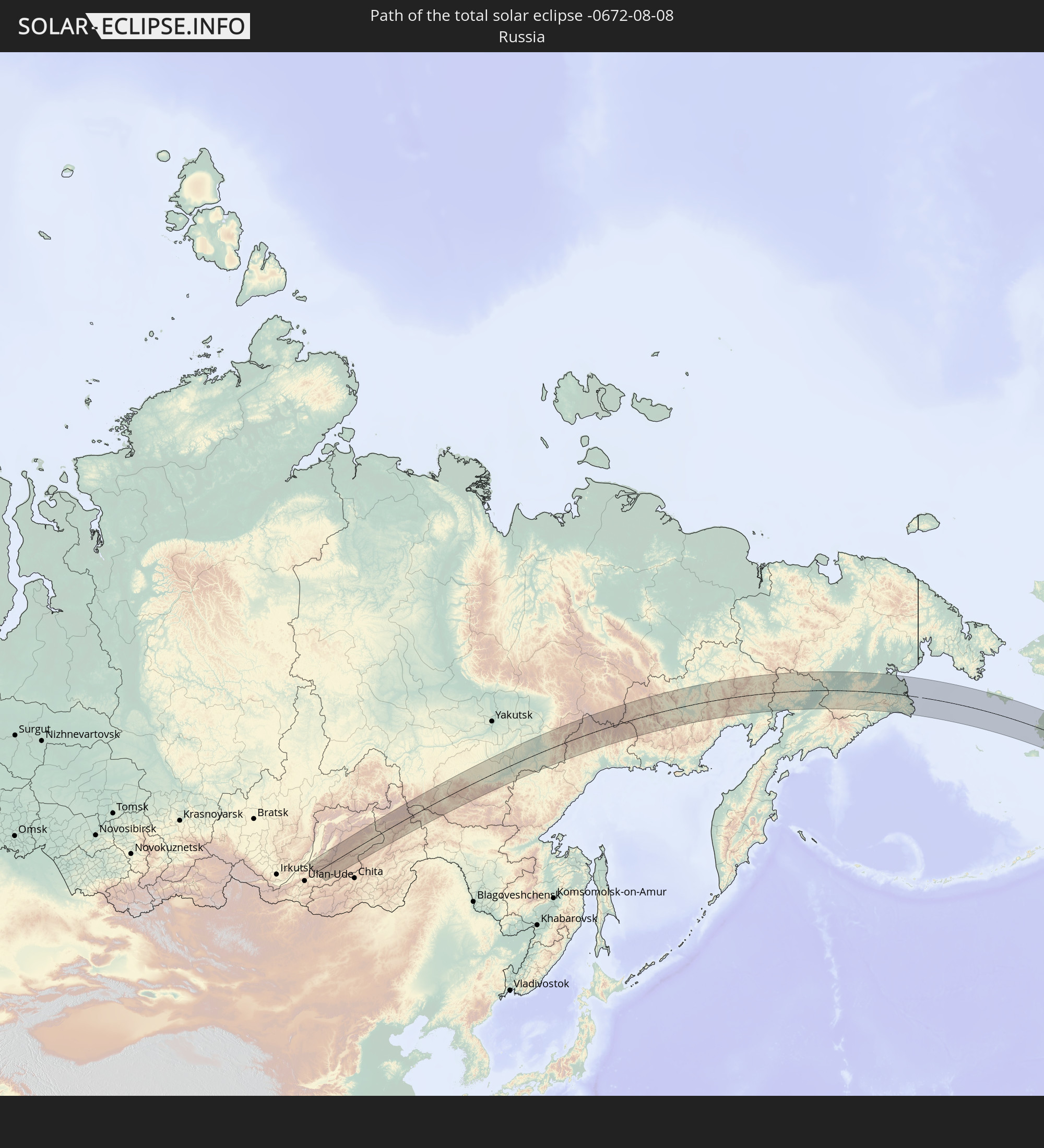 Russia
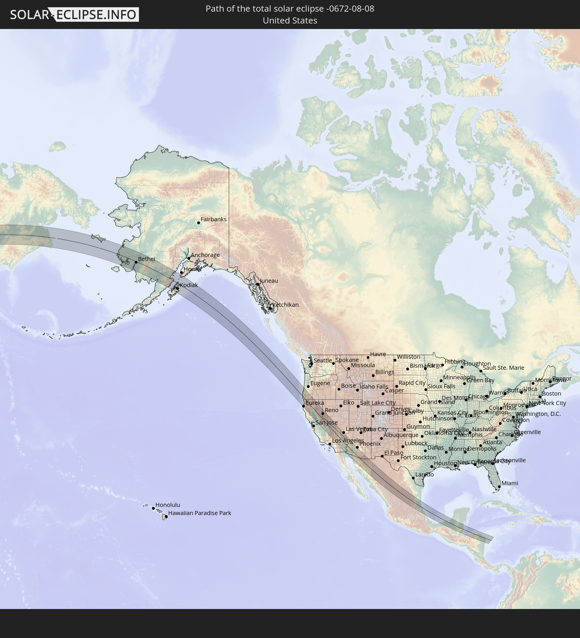 United States
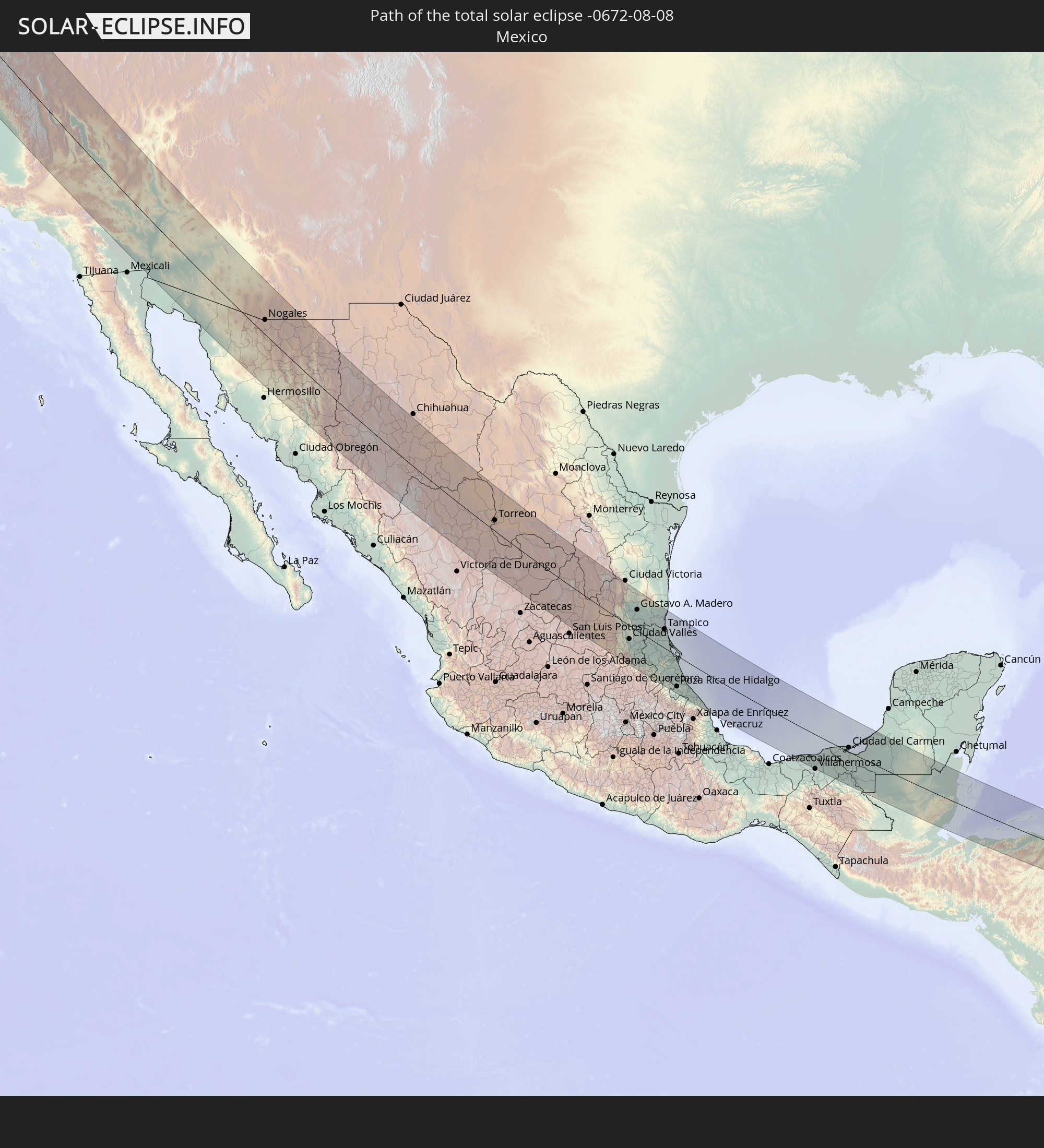 Mexico
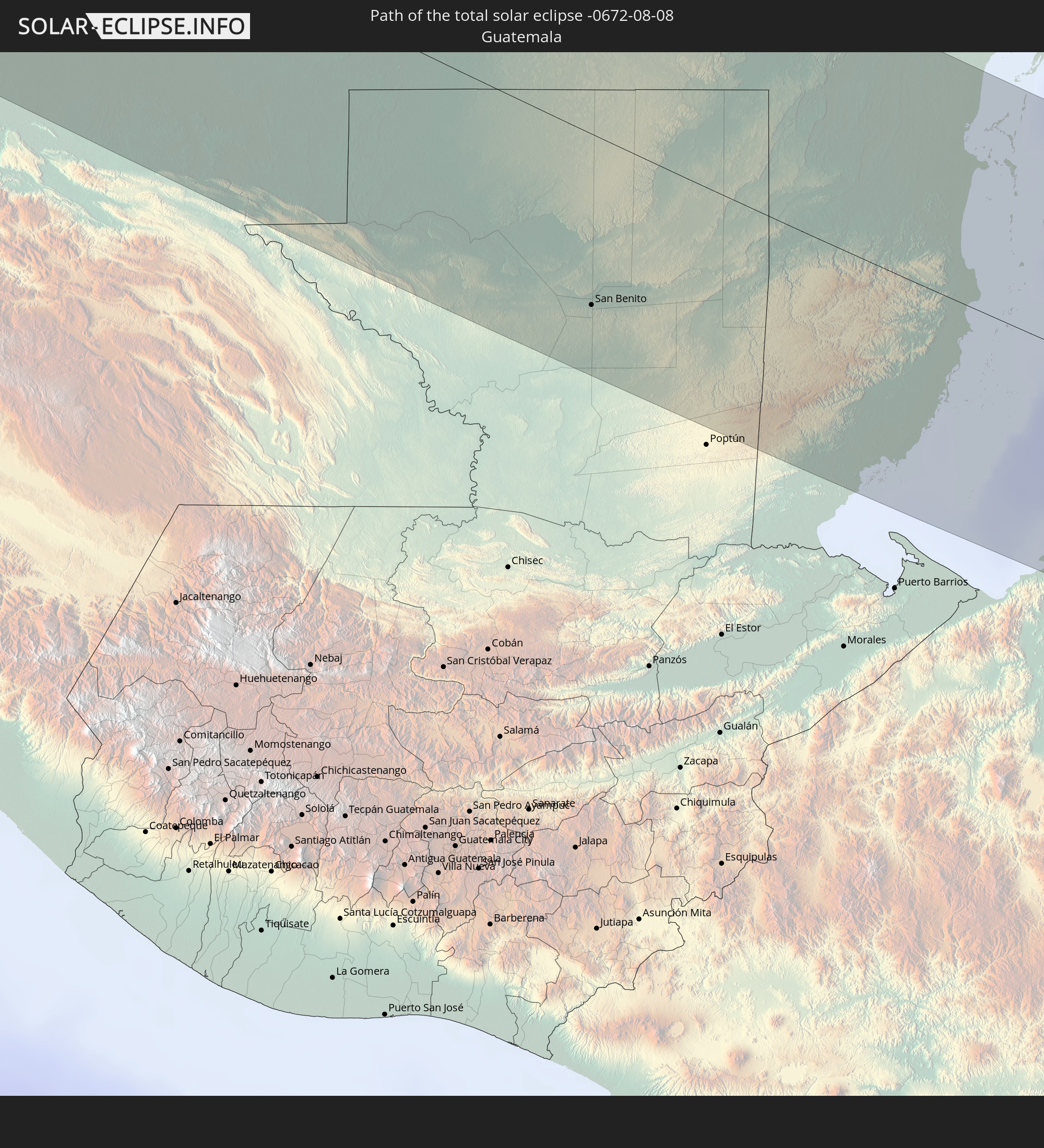 Guatemala
 Honduras
 Belize
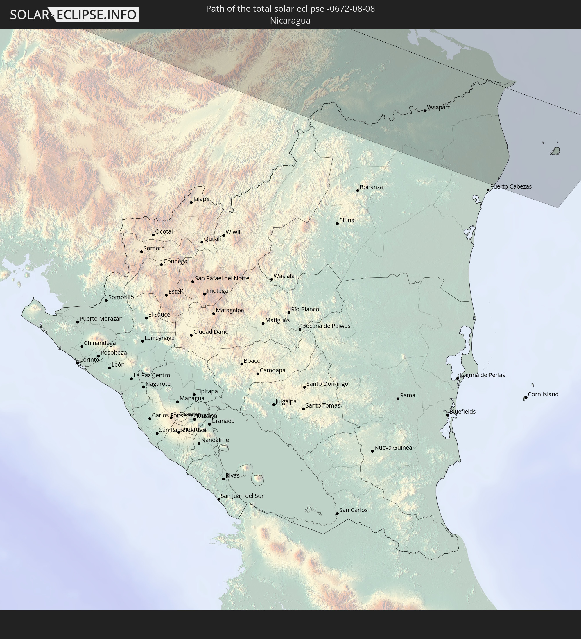 Nicaragua
In den folgenden Ländern ist die Sonnenfinsternis partiell zu sehen


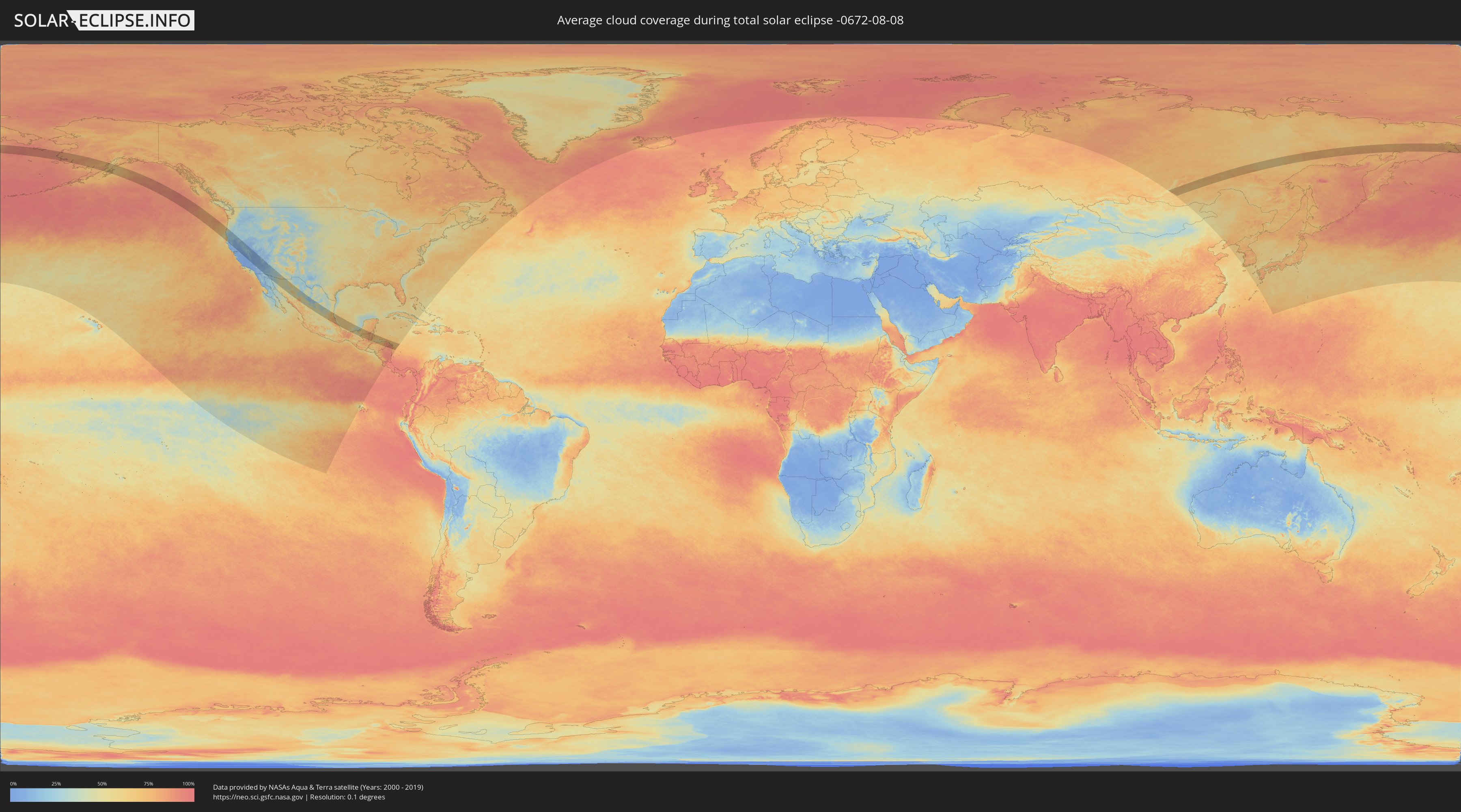
How will be the weather during the total solar eclipse on 08/08/-0672?
Where is the best place to see the total solar eclipse of 08/08/-0672?
The following maps show the average cloud coverage for the day of the total solar eclipse.
With the help of these maps, it is possible to find the place along the eclipse path, which has the best
chance of a cloudless sky.
Nevertheless, you should consider local circumstances and inform about the weather of your chosen
observation site.
The data is provided by NASAs satellites
AQUA and TERRA.
The cloud maps are averaged over a period of 19 years (2000 - 2019).

Detailed country maps
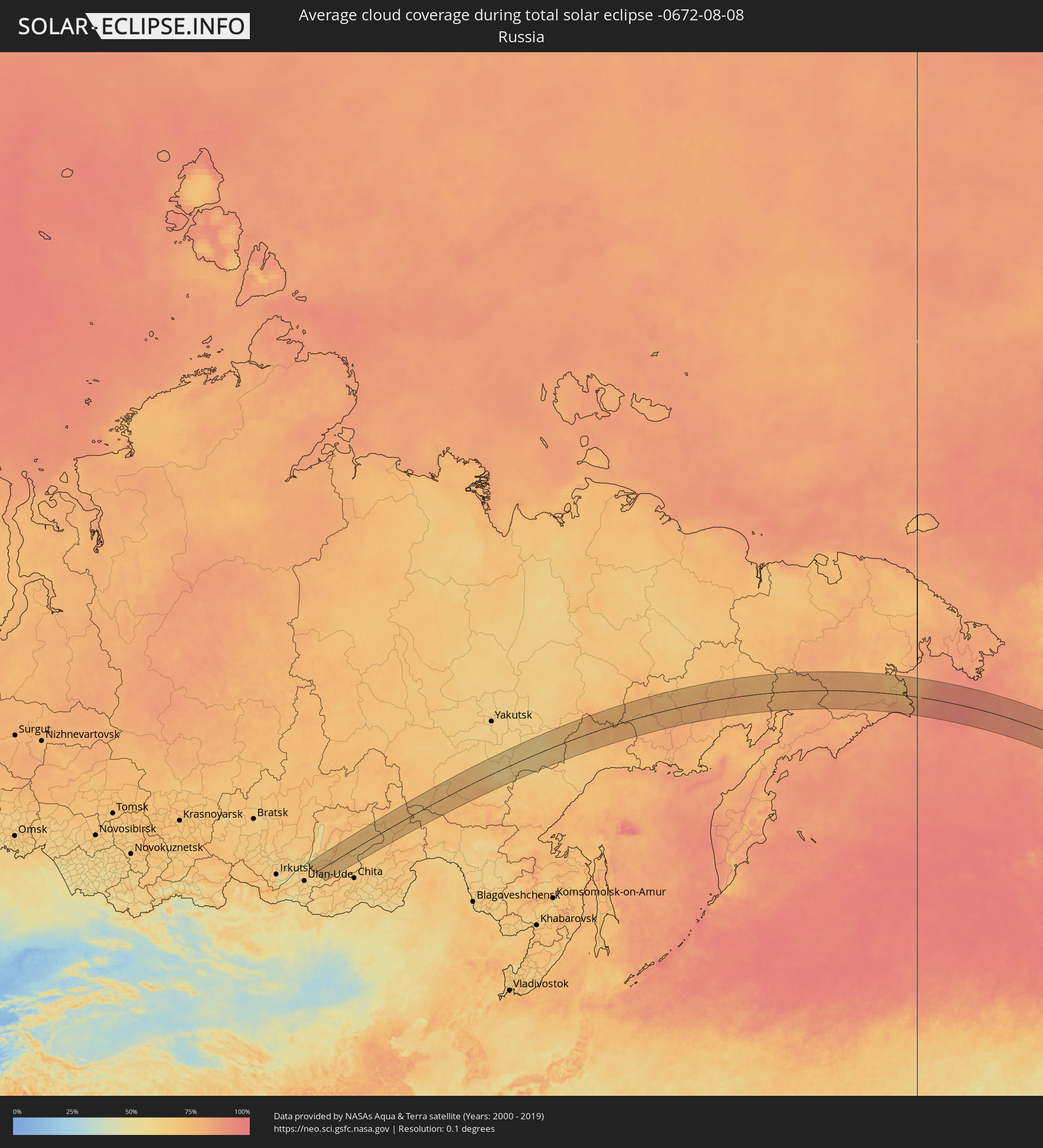 Russia
 United States
 Mexico
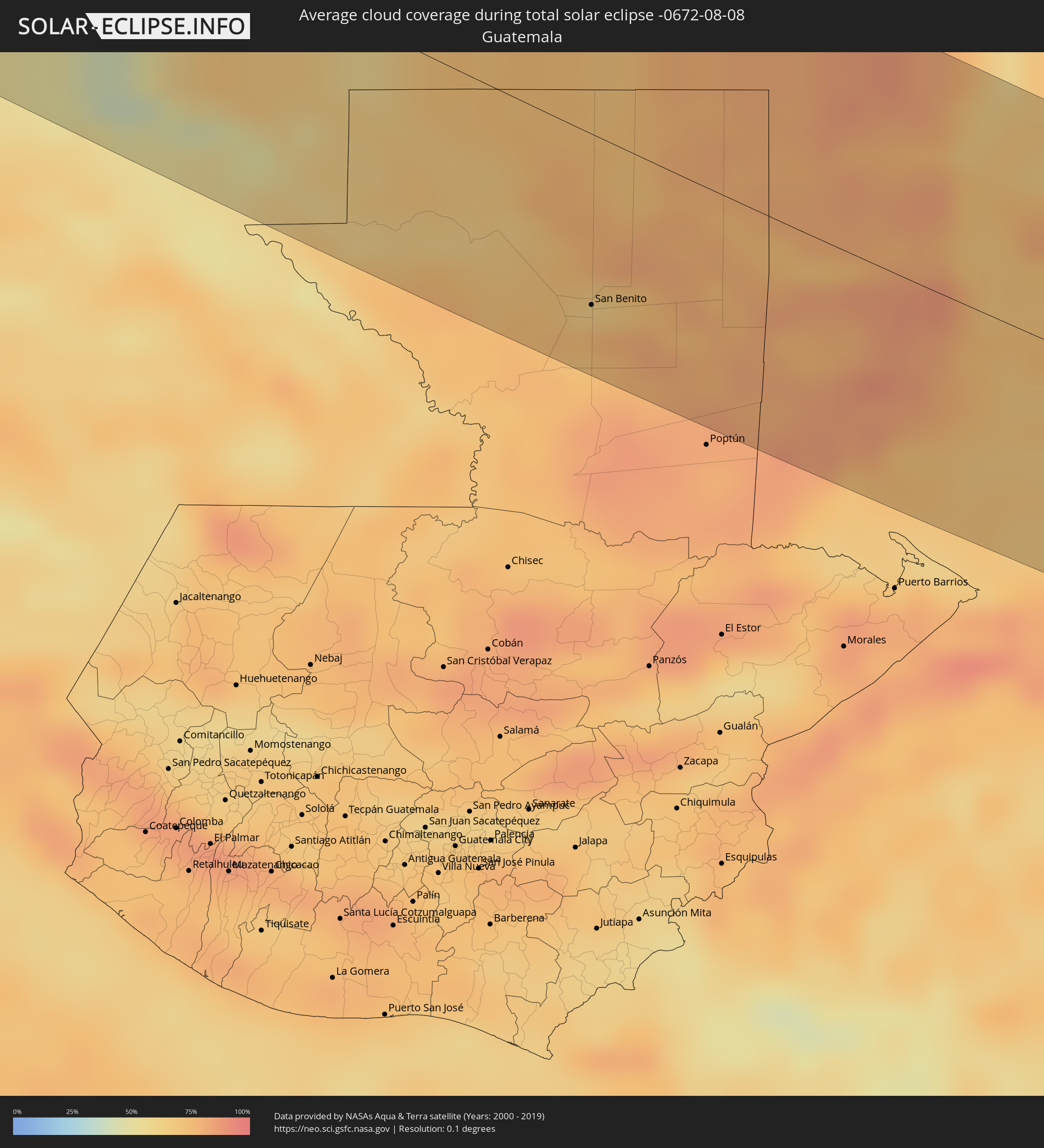 Guatemala
 Honduras
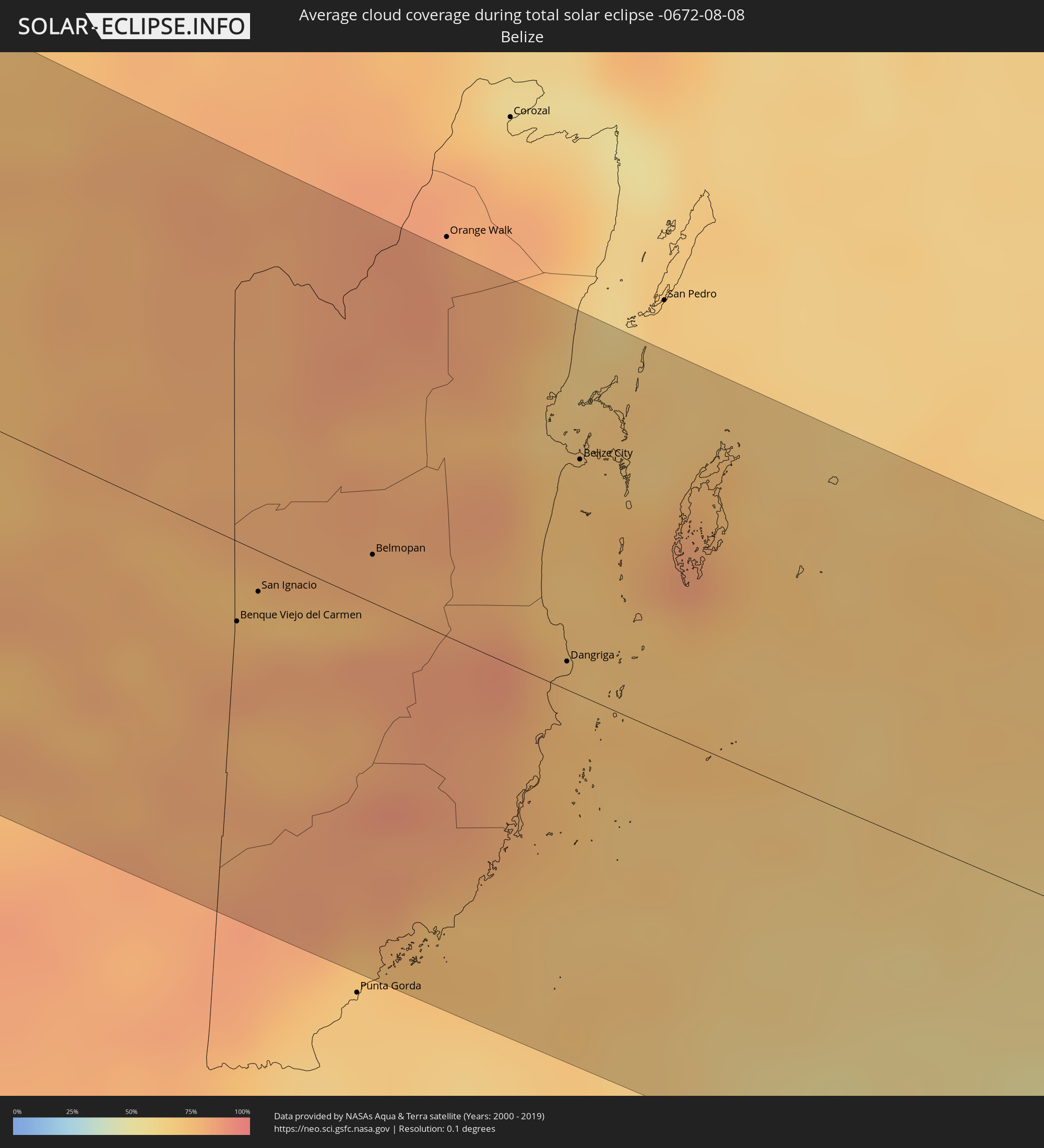 Belize
 Nicaragua
Cities inside the path of the eclipse
The following table shows all locations with a population of more than 5,000 inside the eclipse path. Cities which have more than 100,000 inhabitants are marked bold. A click at the locations opens a detailed map.
| City | Type | Eclipse duration | Local time of max. eclipse | Distance to central line | Ø Cloud coverage |
 Eureka, California
|
total | - | 14:59:01 UTC-08:00 | 113 km | 65% |
|
Grants Pass, Oregon
|
total | - | 14:56:43 UTC-08:00 | 63 km | 20% |
|
Medford, Oregon
|
total | - | 14:57:21 UTC-08:00 | 84 km | 22% |
|
Redding, California
|
total | - | 15:01:01 UTC-08:00 | 15 km | 12% |
|
Chico, California
|
total | - | 15:03:07 UTC-08:00 | 43 km | 11% |
|
Woodland, California
|
total | - | 15:05:09 UTC-08:00 | 120 km | 8% |
|
Yuba City, California
|
total | - | 15:04:25 UTC-08:00 | 72 km | 10% |
|
Sacramento, California
|
total | - | 15:05:34 UTC-08:00 | 106 km | 5% |
|
Elk Grove, California
|
total | - | 15:06:00 UTC-08:00 | 111 km | 7% |
|
Rancho Cordova, California
|
total | - | 15:05:43 UTC-08:00 | 93 km | 5% |
|
Lincoln, California
|
total | - | 15:05:09 UTC-08:00 | 74 km | 8% |
|
Roseville, California
|
total | - | 15:05:25 UTC-08:00 | 81 km | 6% |
|
El Dorado Hills, California
|
total | - | 15:05:43 UTC-08:00 | 72 km | 8% |
|
Reno, Nevada
|
total | - | 15:05:11 UTC-08:00 | 73 km | 16% |
|
Carson City, Nevada
|
total | - | 15:05:54 UTC-08:00 | 55 km | 15% |
|
Ridgecrest, California
|
total | - | 15:14:09 UTC-08:00 | 78 km | 6% |
|
Pahrump, Nevada
|
total | - | 15:14:15 UTC-08:00 | 80 km | 9% |
|
Spring Valley, Nevada
|
total | - | 15:14:56 UTC-08:00 | 123 km | 14% |
|
Yuma, Arizona
|
total | - | 15:21:31 UTC-08:00 | 100 km | 26% |
|
Bullhead City, Arizona
|
total | - | 16:17:08 UTC-07:00 | 96 km | 11% |
|
Lake Havasu City, Arizona
|
total | - | 16:18:30 UTC-07:00 | 65 km | 14% |
|
Buckeye, Arizona
|
total | - | 16:21:34 UTC-07:00 | 93 km | 37% |
|
Avondale, Arizona
|
total | - | 16:21:34 UTC-07:00 | 110 km | 35% |
 Heroica Caborca, Sonora
|
total | - | 16:02:40 UTC-07:23 | 95 km | 36% |
|
Maricopa, Arizona
|
total | - | 16:22:25 UTC-07:00 | 102 km | 41% |
|
Casa Grande, Arizona
|
total | - | 16:22:54 UTC-07:00 | 104 km | 32% |
|
Marana, Arizona
|
total | - | 16:23:58 UTC-07:00 | 104 km | 32% |
|
Oro Valley, Arizona
|
total | - | 16:24:11 UTC-07:00 | 120 km | 36% |
|
Magdalena de Kino, Sonora
|
total | - | 16:03:26 UTC-07:23 | 35 km | 44% |
|
Nogales, Sonora
|
total | - | 16:02:15 UTC-07:23 | 41 km | 48% |
|
Tucson, Arizona
|
total | - | 16:24:30 UTC-07:00 | 111 km | 31% |
|
Sierra Vista, Arizona
|
total | - | 16:26:00 UTC-07:00 | 95 km | 48% |
|
Cananea, Sonora
|
total | - | 16:03:08 UTC-07:23 | 54 km | 50% |
|
Cuauhtémoc, Chihuahua
|
total | - | 16:27:10 UTC-07:05 | 61 km | 43% |
|
Hidalgo del Parral, Chihuahua
|
total | - | 16:30:00 UTC-07:05 | 32 km | 47% |
|
Ciudad Camargo, Chihuahua
|
total | - | 16:28:56 UTC-07:05 | 108 km | 31% |
|
Torreon, Coahuila
|
total | - | 17:01:54 UTC-06:36 | 31 km | 26% |
|
Matamoros, Coahuila
|
total | - | 17:01:58 UTC-06:36 | 39 km | 34% |
|
Río Grande, Zacatecas
|
total | - | 17:04:38 UTC-06:36 | 102 km | 47% |
|
Parras de la Fuente, Coahuila
|
total | - | 17:02:20 UTC-06:36 | 99 km | 47% |
|
Matehuala, San Luis Potosí
|
total | - | 17:05:19 UTC-06:36 | 23 km | 41% |
|
Río Verde, San Luis Potosí
|
total | - | 17:07:55 UTC-06:36 | 98 km | 54% |
|
Ciudad Valles, San Luis Potosí
|
total | - | 17:07:56 UTC-06:36 | 44 km | 64% |
|
Ciudad Mante, Tamaulipas
|
total | - | 17:06:51 UTC-06:36 | 41 km | 58% |
|
Gustavo A. Madero, Tamaulipas
|
total | - | 17:06:41 UTC-06:36 | 60 km | 57% |
|
Huejutla de Reyes, Hidalgo
|
total | - | 17:09:10 UTC-06:36 | 84 km | 70% |
|
Tantoyuca, Veracruz
|
total | - | 17:08:53 UTC-06:36 | 54 km | 78% |
|
Pánuco, Veracruz
|
total | - | 17:07:54 UTC-06:36 | 33 km | 67% |
|
Tampico, Tamaulipas
|
total | - | 17:07:36 UTC-06:36 | 57 km | 62% |
|
Temapache, Veracruz
|
total | - | 17:09:19 UTC-06:36 | 50 km | 76% |
|
Poza Rica de Hidalgo, Veracruz
|
total | - | 17:10:04 UTC-06:36 | 89 km | 83% |
|
Tuxpan de Rodríguez Cano, Veracruz
|
total | - | 17:09:28 UTC-06:36 | 51 km | 64% |
|
Papantla de Olarte, Veracruz
|
total | - | 17:10:11 UTC-06:36 | 92 km | 86% |
|
Comalcalco, Tabasco
|
total | - | 17:12:55 UTC-06:36 | 92 km | 74% |
|
Paraiso, Tabasco
|
total | - | 17:12:44 UTC-06:36 | 78 km | 67% |
|
Ciudad del Carmen, Campeche
|
total | - | 17:12:17 UTC-06:36 | 13 km | 44% |
|
Tenosique de Pino Suárez, Tabasco
|
total | - | 17:13:41 UTC-06:36 | 85 km | 60% |
|
Escárcega, Campeche
|
total | - | 17:12:11 UTC-06:36 | 60 km | 66% |
 La Libertad, Petén
|
total | - | 17:48:51 UTC-06:02 | 94 km | 73% |
|
San Benito, Petén
|
total | - | 17:48:39 UTC-06:02 | 72 km | 77% |
|
San Andrés, Petén
|
total | - | 17:48:36 UTC-06:02 | 67 km | 65% |
|
Flores, Petén
|
total | - | 17:48:39 UTC-06:02 | 71 km | 77% |
|
Santa Ana, Petén
|
total | - | 17:48:47 UTC-06:02 | 80 km | 76% |
|
Dolores, Petén
|
total | - | 17:49:02 UTC-06:02 | 91 km | 83% |
|
Melchor de Mencos, Petén
|
total | - | 17:48:20 UTC-06:02 | 24 km | 79% |
 Benque Viejo del Carmen, Cayo
|
total | - | 17:57:35 UTC-05:52 | 22 km | 79% |
|
San Ignacio, Cayo
|
total | - | 17:57:29 UTC-05:52 | 12 km | 74% |
|
Belmopan, Cayo
|
total | - | 17:57:18 UTC-05:52 | 25 km | 80% |
|
Dangriga, Stann Creek
|
total | - | 17:57:32 UTC-05:52 | 8 km | 70% |
|
Belize City, Belize
|
total | - | 17:56:54 UTC-05:52 | 63 km | 72% |
 Puerto Cortez, Cortés
|
total | - | 18:02:43 UTC-05:48 | 96 km | 77% |
|
Baracoa, Cortés
|
total | - | 18:02:46 UTC-05:48 | 99 km | 77% |
|
Tela, Atlántida
|
total | - | 18:02:40 UTC-05:48 | 84 km | 65% |
|
San Juan Pueblo, Atlántida
|
total | - | 18:02:50 UTC-05:48 | 93 km | 84% |
|
La Ceiba, Atlántida
|
total | - | 18:02:31 UTC-05:48 | 56 km | 66% |
|
Olanchito, Yoro
|
total | - | 18:02:46 UTC-05:48 | 78 km | 61% |
|
Coxen Hole, Bay Islands
|
total | - | 18:01:49 UTC-05:48 | 16 km | 60% |
|
Sabá, Colón
|
total | - | 18:02:42 UTC-05:48 | 64 km | 72% |
|
Tocoa, Colón
|
total | - | 18:02:24 UTC-05:48 | 34 km | 68% |
|
Trujillo, Colón
|
total | - | 18:02:07 UTC-05:48 | 9 km | 64% |
 Waspam, Atlántico Norte (RAAN)
|
total | - | 18:06:30 UTC-05:45 | 54 km | 92% |
|
Puerto Lempira, Gracias a Dios
|
total | - | 18:02:12 UTC-05:48 | 25 km | 78% |
 Ust’-Barguzin, Respublika Buryatiya
|
total | - | 04:01:31 UTC+06:57 | 88 km | 62% |
|
Barguzin, Respublika Buryatiya
|
total | - | 04:01:31 UTC+06:57 | 86 km | 67% |
|
Khorinsk, Respublika Buryatiya
|
total | - | 04:00:03 UTC+06:57 | 60 km | 66% |
|
Sosnovo-Ozerskoye, Respublika Buryatiya
|
total | - | 03:59:49 UTC+06:57 | 86 km | 63% |
|
Neryungri, Sakha
|
total | - | 05:43:36 UTC+08:38 | 96 km | 74% |
|
Chul’man, Sakha
|
total | - | 05:43:47 UTC+08:38 | 87 km | 72% |
|
Aldan, Sakha
|
total | - | 05:45:54 UTC+08:38 | 75 km | 74% |
|
Nizhniy Kuranakh, Sakha
|
total | - | 05:46:09 UTC+08:38 | 94 km | 71% |
|
Tommot, Sakha
|
total | - | 05:46:17 UTC+08:38 | 86 km | 69% |
|
Susuman, Magadan
|
total | - | 07:30:18 UTC+10:14 | 44 km | 73% |