Total solar eclipse of 08/26/-0812
| Day of week: | Thursday |
| Maximum duration of eclipse: | 05m13s |
| Maximum width of eclipse path: | 203 km |
| Saros cycle: | 51 |
| Coverage: | 100% |
| Magnitude: | 1.0605 |
| Gamma: | 0.2064 |
Wo kann man die Sonnenfinsternis vom 08/26/-0812 sehen?

Die Sonnenfinsternis am 08/26/-0812 kann man in 56 Ländern als partielle Sonnenfinsternis beobachten.
Der Finsternispfad verläuft durch 13 Länder. Nur in diesen Ländern ist sie als total Sonnenfinsternis zu sehen.
In den folgenden Ländern ist die Sonnenfinsternis total zu sehen
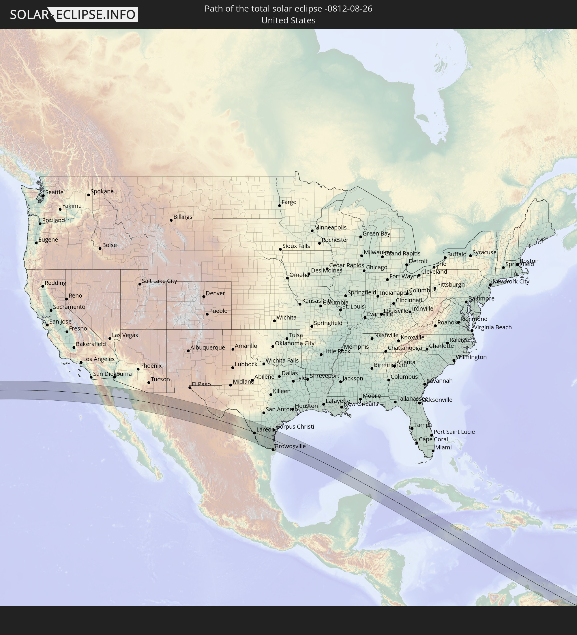 United States
 Mexico
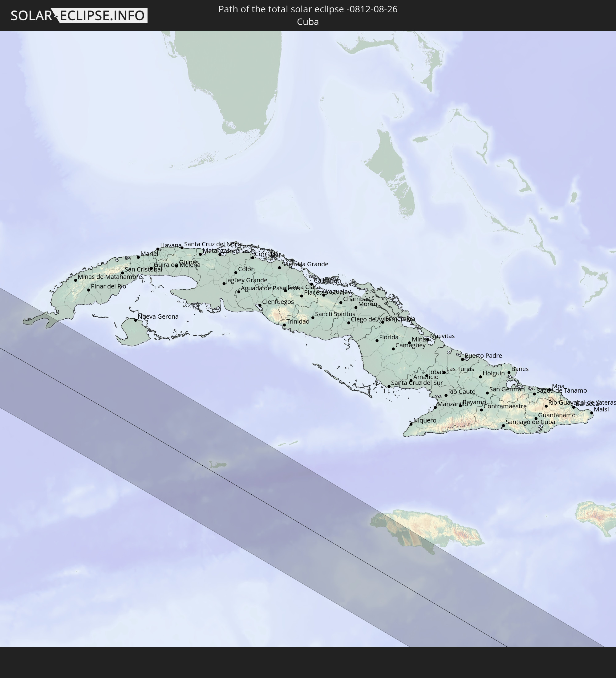 Cuba
Cuba
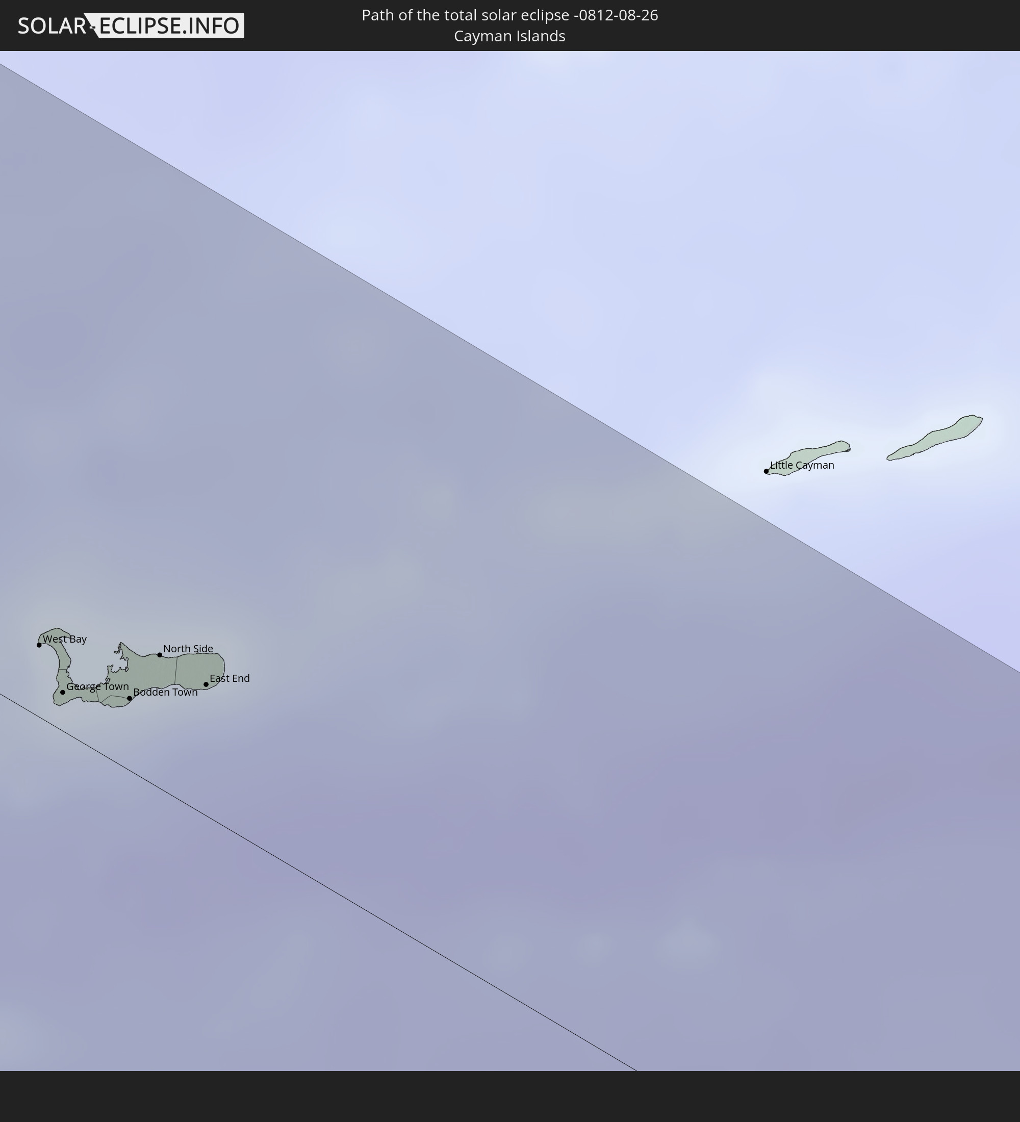 Cayman Islands
 Jamaica
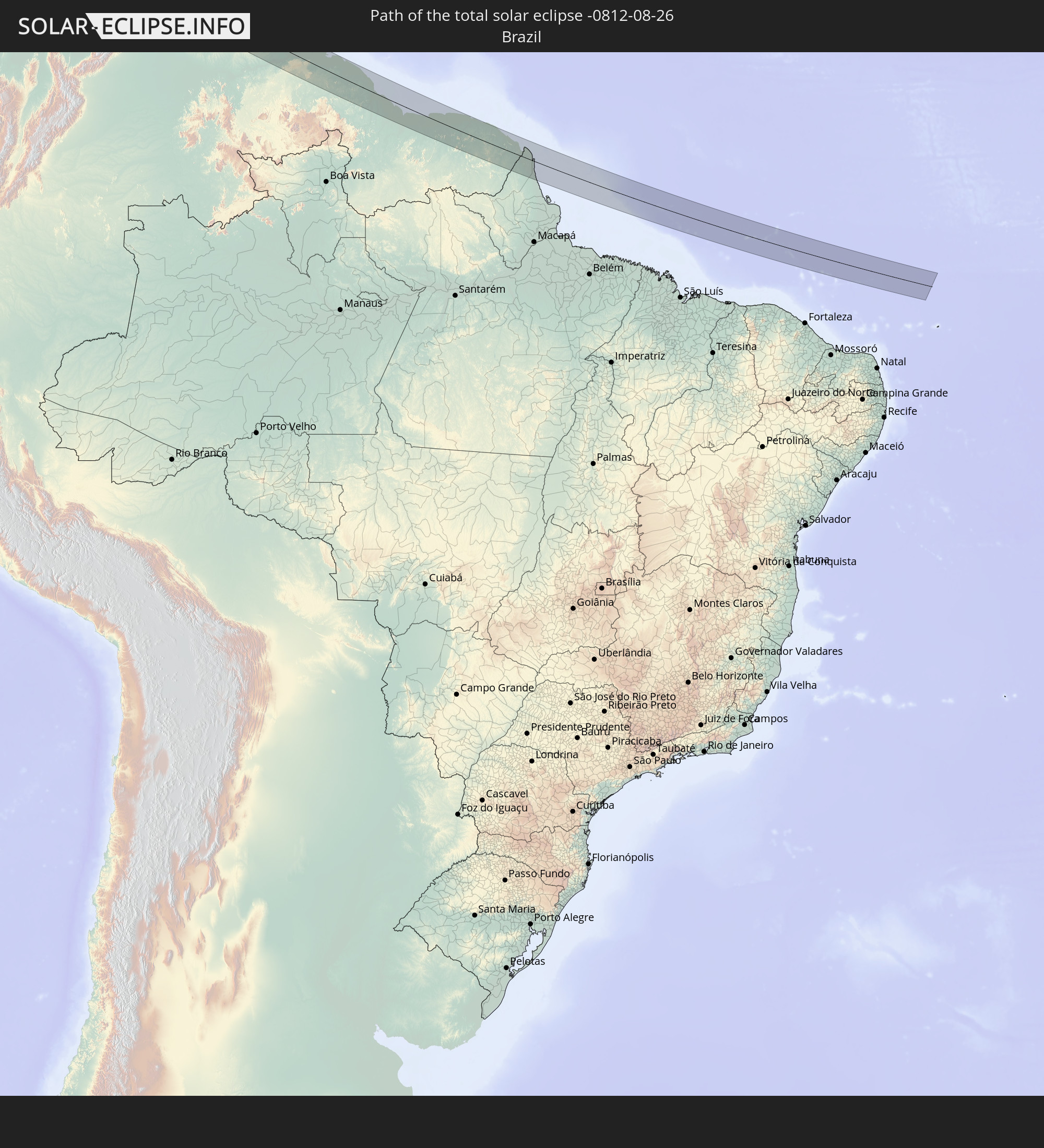 Brazil
 Venezuela
 Aruba
Aruba
 Curaçao
 Guyana
 Suriname
 French Guiana
 Caribbean Netherlands
In den folgenden Ländern ist die Sonnenfinsternis partiell zu sehen
 Russia
 United States
 United States Minor Outlying Islands
 Kiribati
 Canada
 Mexico
 Chile
Chile
 Greenland
 Guatemala
 Ecuador
 El Salvador
 Honduras
 Belize
 Nicaragua
 Costa Rica
 Cuba
Cuba
 Panama
 Colombia
 Cayman Islands
 Peru
Peru
 The Bahamas
 Jamaica
 Haiti
Haiti
 Brazil
 Argentina
 Venezuela
 Turks and Caicos Islands
 Dominican Republic
 Aruba
Aruba
 Bolivia
 Puerto Rico
 United States Virgin Islands
 Bermuda
 British Virgin Islands
 Anguilla
 Collectivity of Saint Martin
 Saint Barthélemy
 Saint Kitts and Nevis
 Paraguay
 Antigua and Barbuda
 Montserrat
 Trinidad and Tobago
 Guadeloupe
 Grenada
 Dominica
 Saint Vincent and the Grenadines
 Guyana
 Martinique
 Saint Lucia
 Barbados
 Suriname
 Saint Pierre and Miquelon
 French Guiana
 Portugal
 Cabo Verde
 Spain
Spain
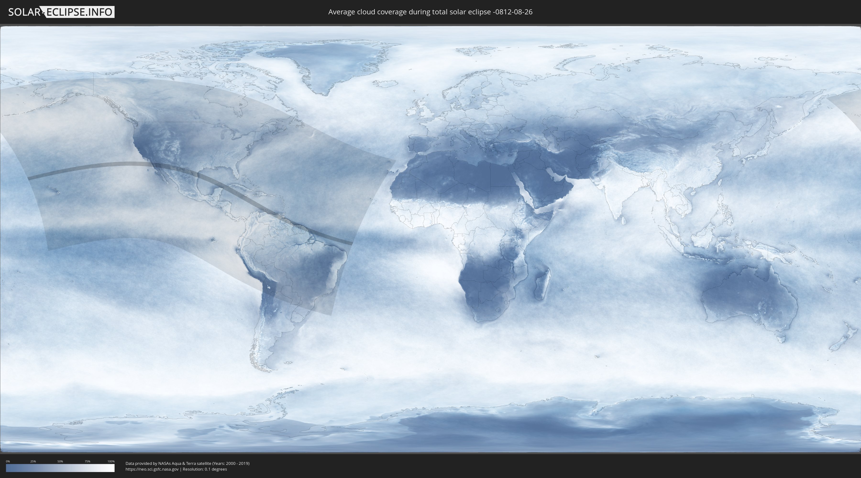
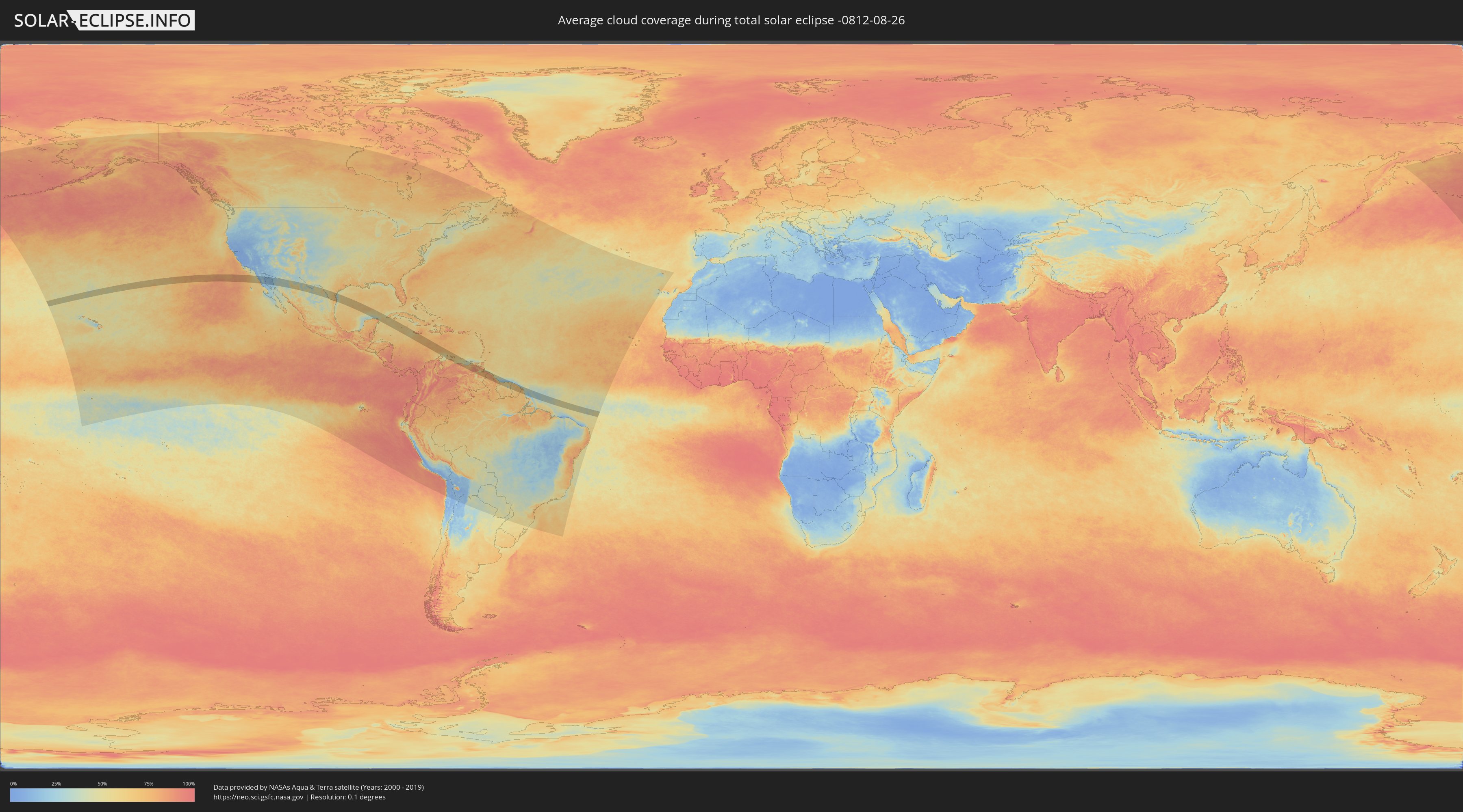
How will be the weather during the total solar eclipse on 08/26/-0812?
Where is the best place to see the total solar eclipse of 08/26/-0812?
The following maps show the average cloud coverage for the day of the total solar eclipse.
With the help of these maps, it is possible to find the place along the eclipse path, which has the best
chance of a cloudless sky.
Nevertheless, you should consider local circumstances and inform about the weather of your chosen
observation site.
The data is provided by NASAs satellites
AQUA and TERRA.
The cloud maps are averaged over a period of 19 years (2000 - 2019).
Detailed country maps
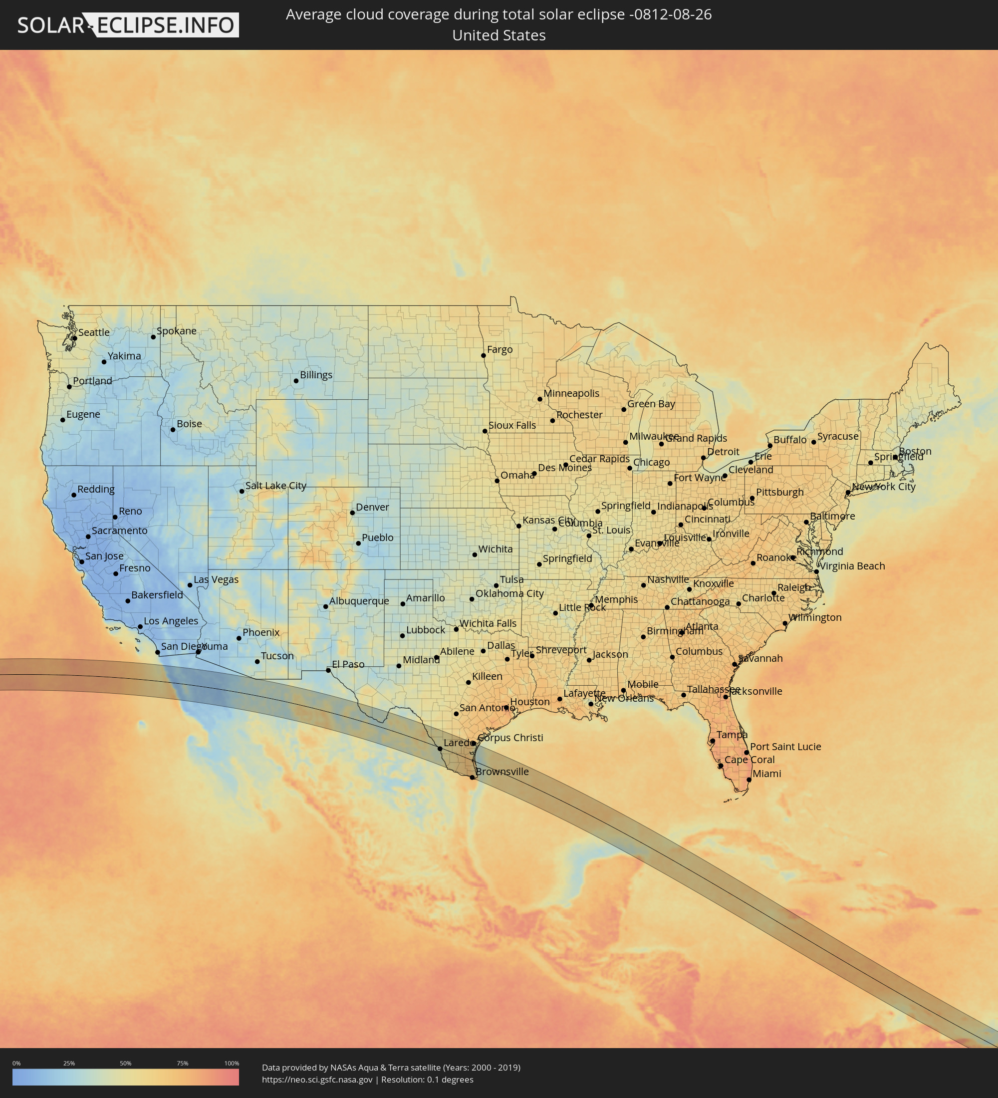 United States
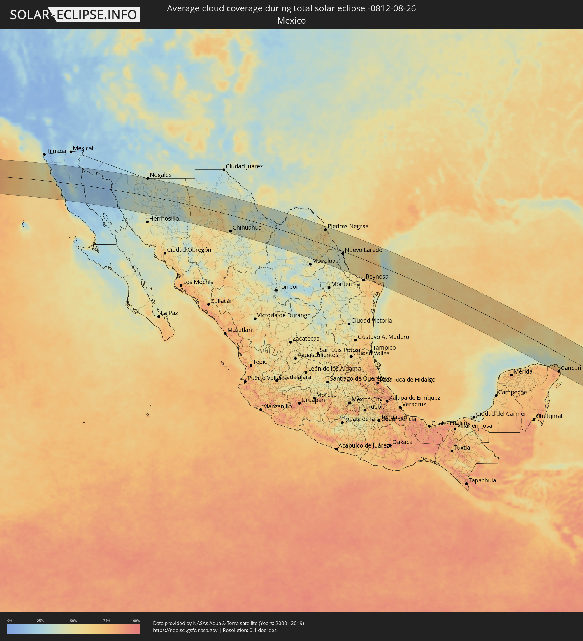 Mexico
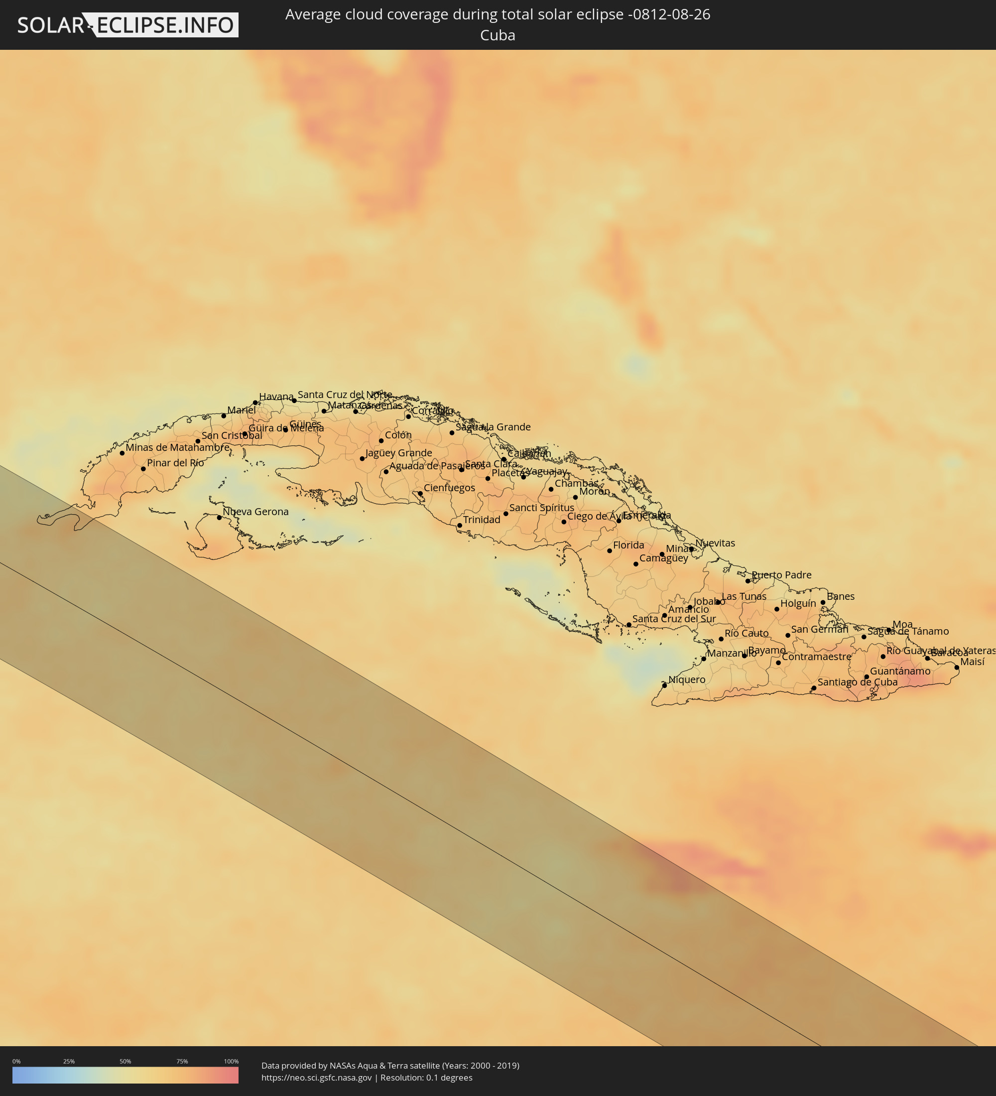 Cuba
Cuba
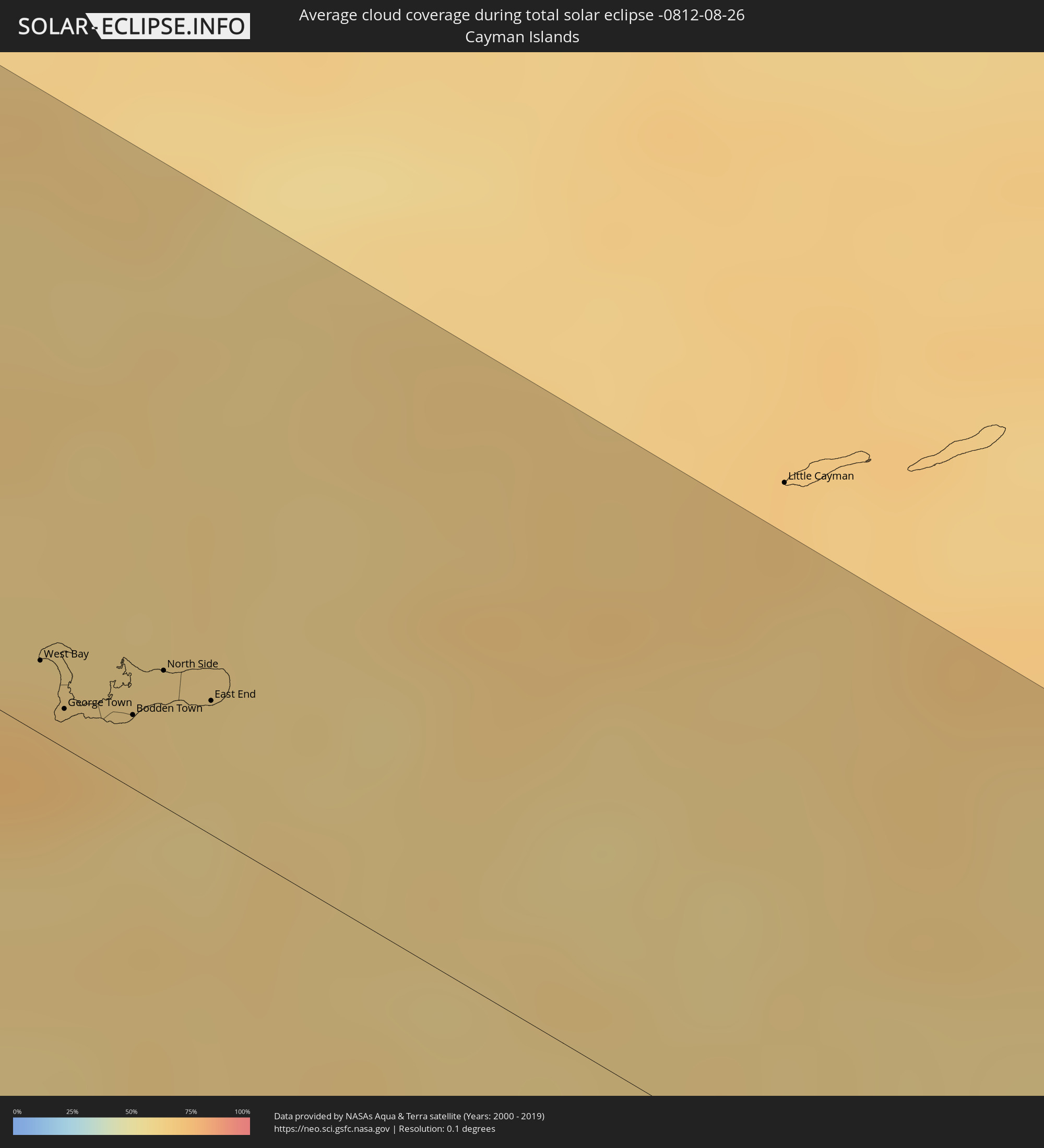 Cayman Islands
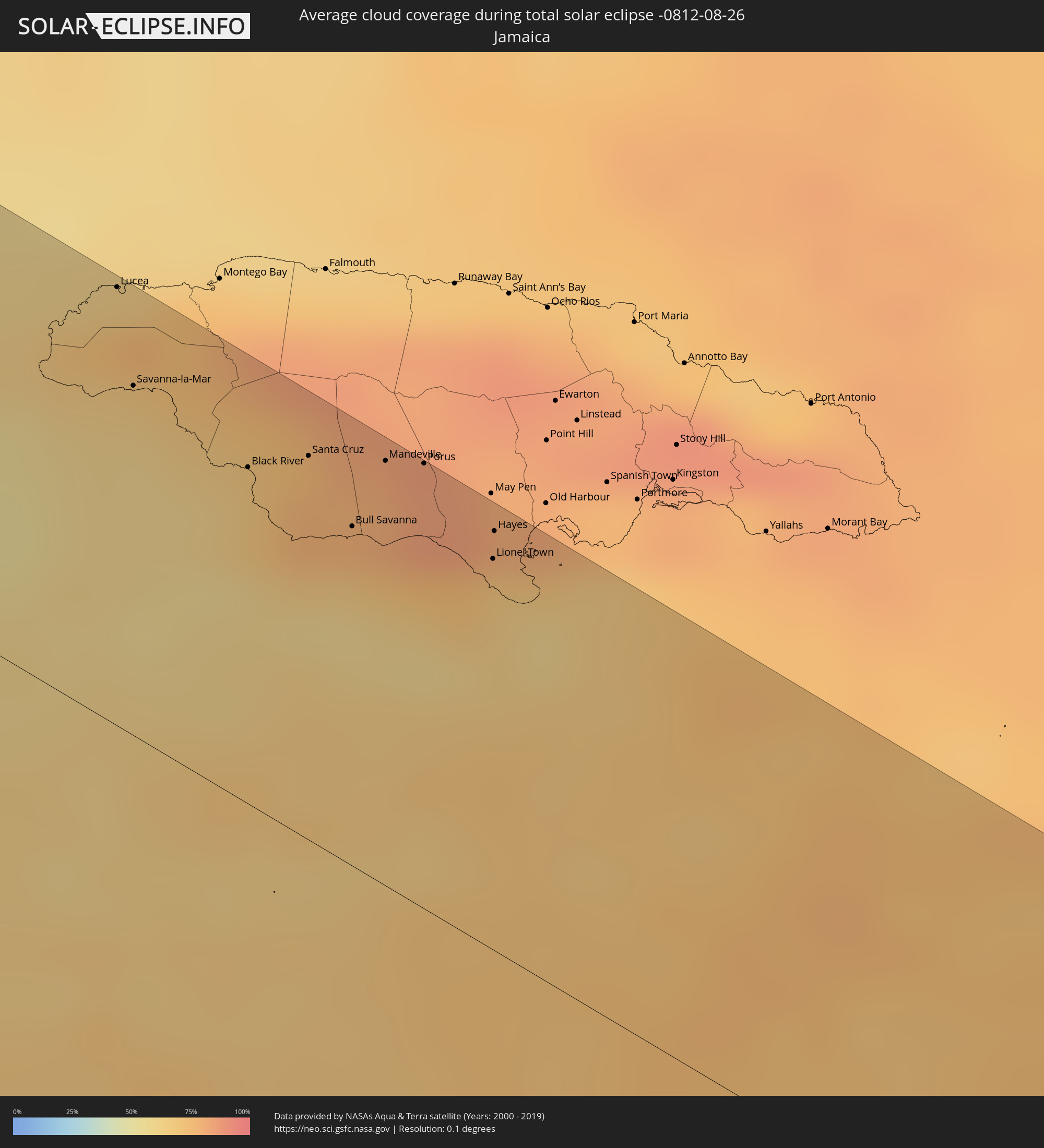 Jamaica
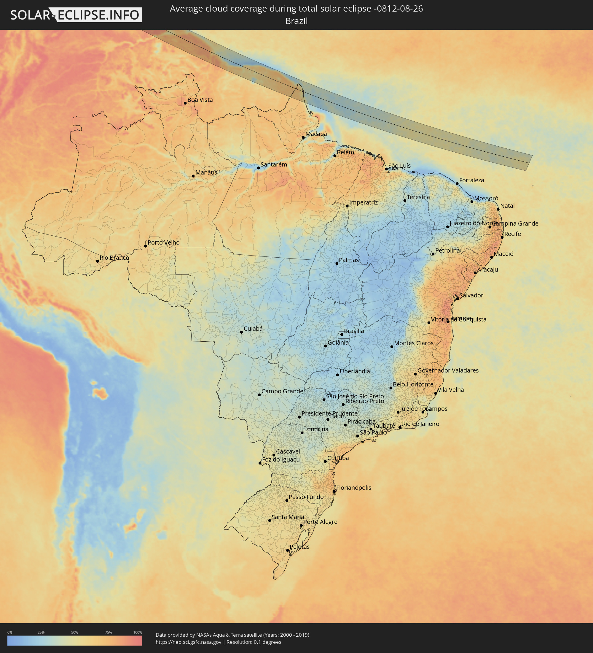 Brazil
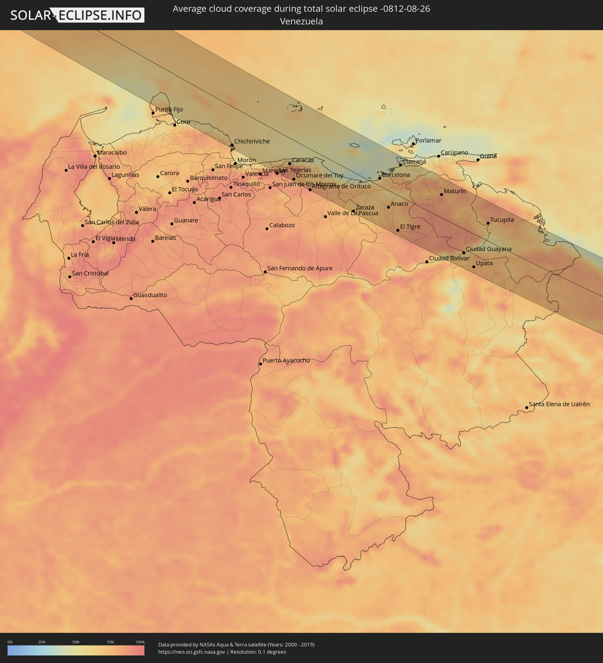 Venezuela
 Aruba
Aruba
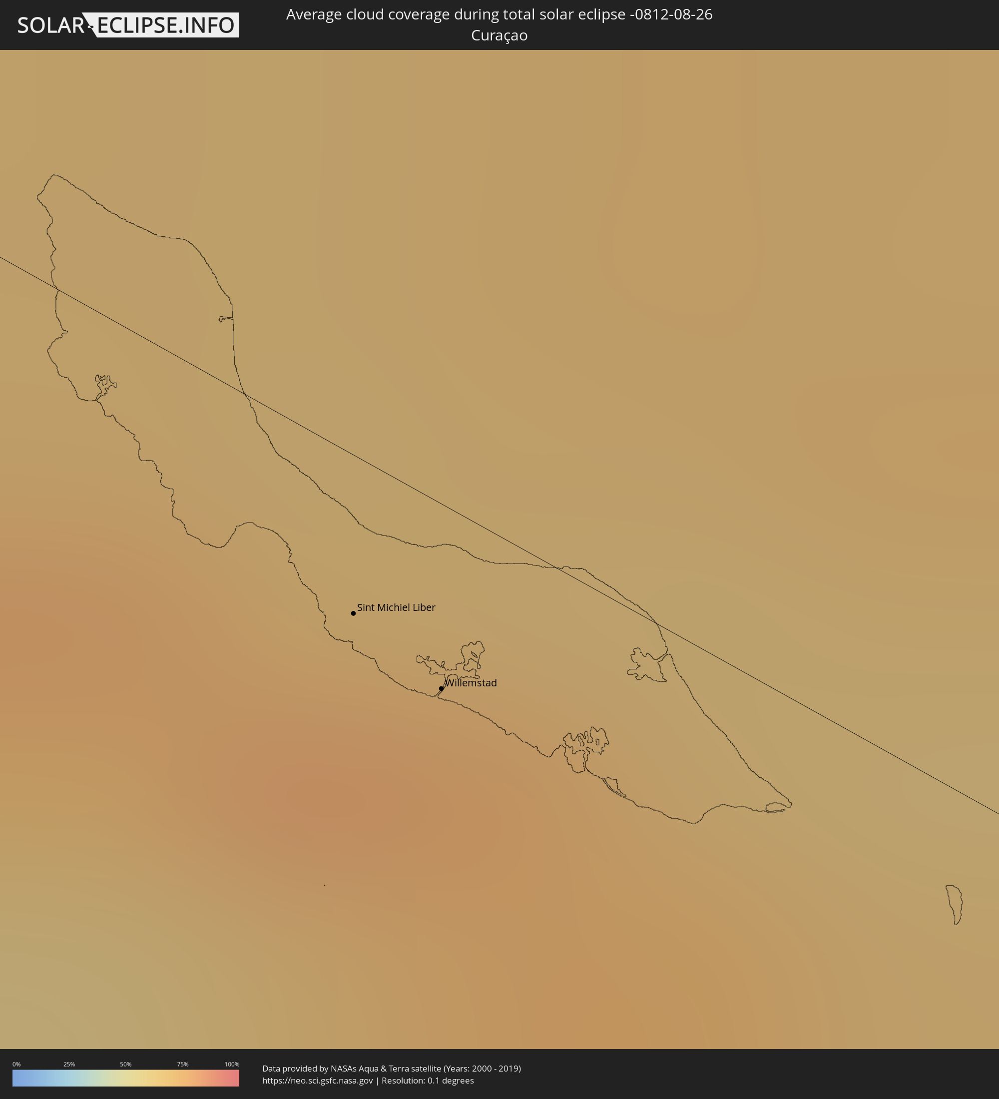 Curaçao
 Guyana
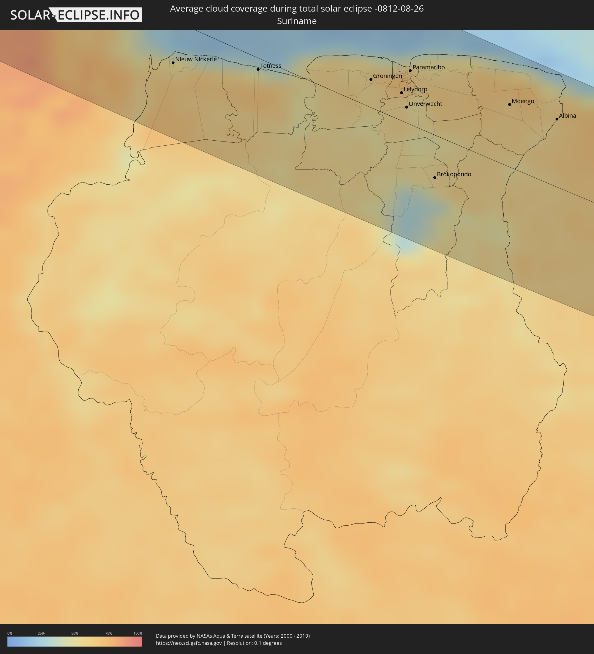 Suriname
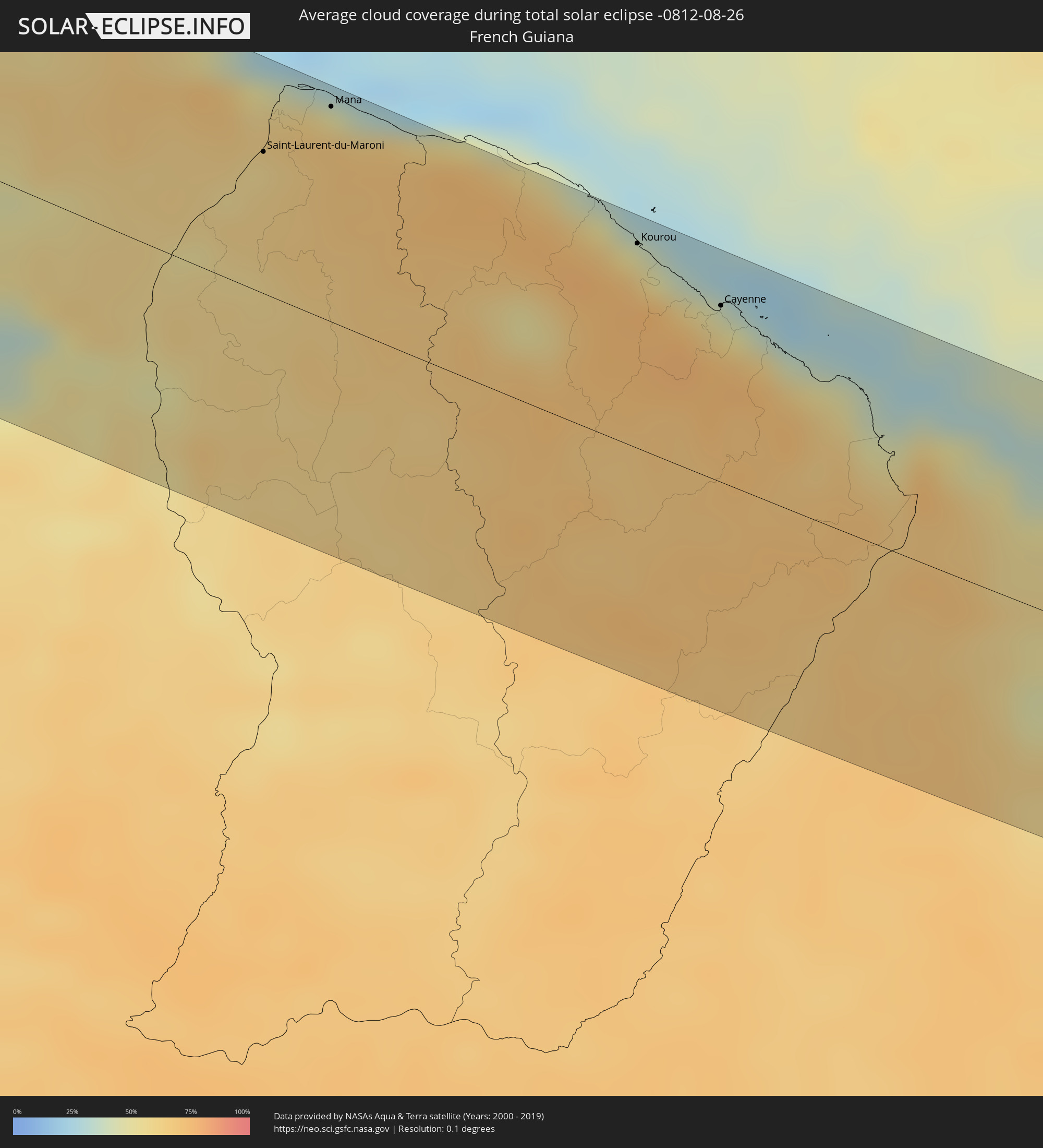 French Guiana
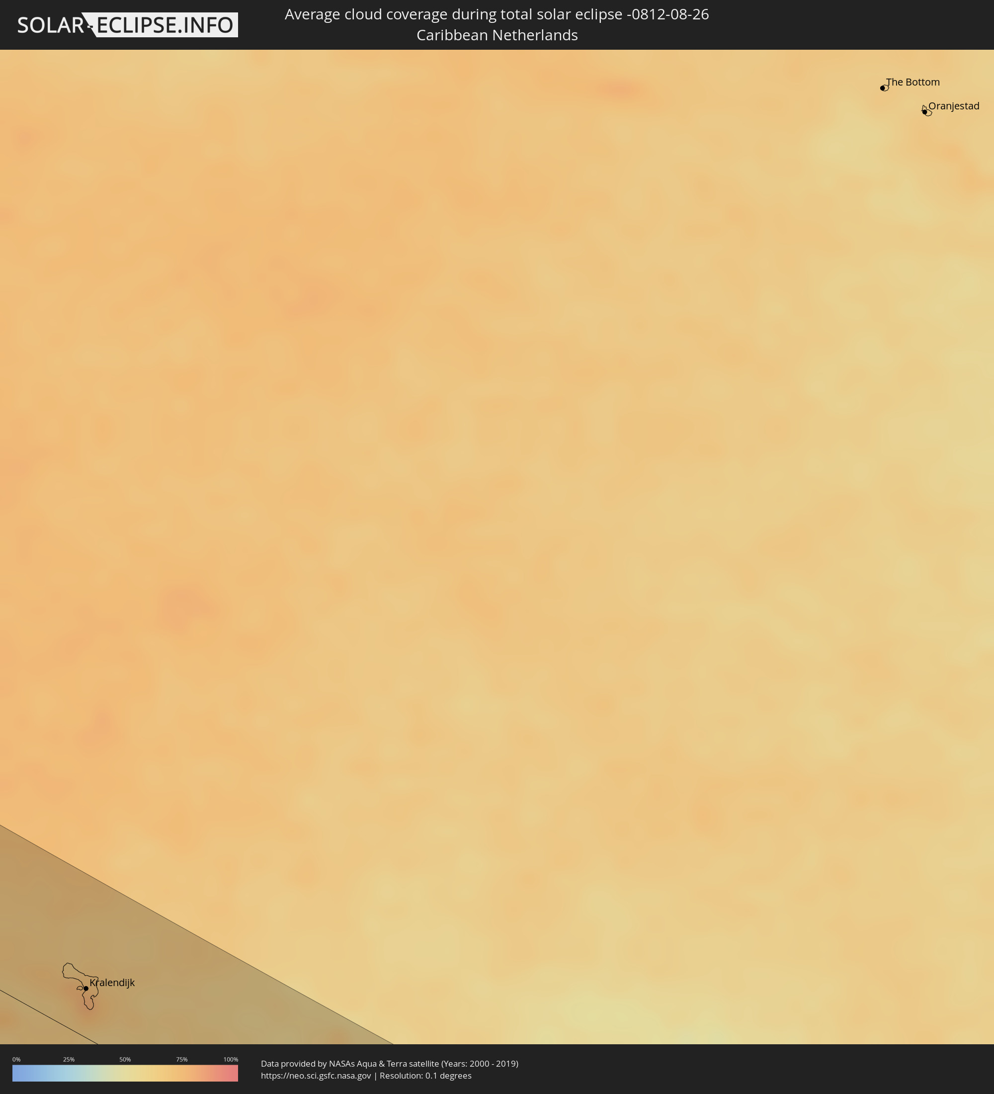 Caribbean Netherlands
Cities inside the path of the eclipse
The following table shows all locations with a population of more than 5,000 inside the eclipse path. Cities which have more than 100,000 inhabitants are marked bold. A click at the locations opens a detailed map.
| City | Type | Eclipse duration | Local time of max. eclipse | Distance to central line | Ø Cloud coverage |
|
Ensenada, Baja California
|
total | - | 09:46:19 UTC-07:48 | 77 km | 24% |
|
Rodolfo Sánchez Taboada, Baja California
|
total | - | 09:46:22 UTC-07:48 | 61 km | 23% |
|
San Felipe, Baja California
|
total | - | 09:49:43 UTC-07:48 | 4 km | 16% |
|
Puerto Peñasco, Sonora
|
total | - | 10:16:29 UTC-07:23 | 55 km | 19% |
|
Heroica Caborca, Sonora
|
total | - | 10:19:24 UTC-07:23 | 10 km | 32% |
|
Magdalena de Kino, Sonora
|
total | - | 10:21:56 UTC-07:23 | 21 km | 33% |
|
Nogales, Sonora
|
total | - | 10:21:49 UTC-07:23 | 96 km | 35% |
|
Cananea, Sonora
|
total | - | 10:23:16 UTC-07:23 | 73 km | 38% |
|
San Pedro Madera, Chihuahua
|
total | - | 10:46:47 UTC-07:05 | 78 km | 49% |
|
Nuevo Casas Grandes, Chihuahua
|
total | - | 10:46:48 UTC-07:05 | 60 km | 37% |
|
Chihuahua, Chihuahua
|
total | - | 10:51:47 UTC-07:05 | 89 km | 52% |
|
Manuel Ojinaga, Chihuahua
|
total | - | 10:55:07 UTC-07:05 | 55 km | 35% |
|
Melchor Múzquiz, Coahuila
|
total | - | 11:32:11 UTC-06:36 | 37 km | 45% |
|
Ciudad Sabinas, Coahuila
|
total | - | 11:33:10 UTC-06:36 | 27 km | 51% |
|
Allende, Coahuila
|
total | - | 11:33:24 UTC-06:36 | 33 km | 54% |
|
Piedras Negras, Coahuila
|
total | - | 11:33:53 UTC-06:36 | 82 km | 58% |
|
Eagle Pass, Texas
|
total | - | 12:10:32 UTC-06:00 | 83 km | 58% |
|
Eidson Road, Texas
|
total | - | 12:10:35 UTC-06:00 | 80 km | 58% |
|
Ciudad Anáhuac, Nuevo León
|
total | - | 11:36:04 UTC-06:36 | 58 km | 47% |
|
Nuevo Laredo, Tamaulipas
|
total | - | 11:37:21 UTC-06:36 | 12 km | 45% |
|
Laredo, Texas
|
total | - | 12:13:56 UTC-06:00 | 9 km | 45% |
|
McAllen, Texas
|
total | - | 12:18:18 UTC-06:00 | 98 km | 64% |
|
Nurillo, Texas
|
total | - | 12:18:30 UTC-06:00 | 87 km | 62% |
|
Murillo Colonia, Texas
|
total | - | 12:18:32 UTC-06:00 | 88 km | 62% |
|
Alice, Texas
|
total | - | 12:17:09 UTC-06:00 | 68 km | 60% |
|
Elsa, Texas
|
total | - | 12:18:47 UTC-06:00 | 80 km | 64% |
|
Weslaco, Texas
|
total | - | 12:18:56 UTC-06:00 | 94 km | 63% |
|
Mila Doce, Texas
|
total | - | 12:18:56 UTC-06:00 | 85 km | 63% |
|
Kingsville, Texas
|
total | - | 12:17:54 UTC-06:00 | 51 km | 65% |
|
La Feria, Texas
|
total | - | 12:19:20 UTC-06:00 | 87 km | 68% |
|
Raymondville, Texas
|
total | - | 12:19:06 UTC-06:00 | 53 km | 71% |
|
Harlingen, Texas
|
total | - | 12:19:37 UTC-06:00 | 79 km | 72% |
|
Robstown, Texas
|
total | - | 12:18:04 UTC-06:00 | 87 km | 66% |
|
Cameron Park Colonia, Texas
|
total | - | 12:20:23 UTC-06:00 | 94 km | 74% |
|
Cameron Park, Texas
|
total | - | 12:20:23 UTC-06:00 | 94 km | 74% |
|
Los Fresnos, Texas
|
total | - | 12:20:17 UTC-06:00 | 83 km | 73% |
|
Corpus Christi, Texas
|
total | - | 12:18:43 UTC-06:00 | 98 km | 50% |
|
Cancún, Quintana Roo
|
total | - | 13:04:58 UTC-05:47 | 96 km | 70% |
|
West Bay, West Bay
|
total | - | 13:46:49 UTC-05:19 | 12 km | 69% |
|
George Town, George Town
|
total | - | 13:47:02 UTC-05:19 | 6 km | 72% |
|
Bodden Town, Bodden Town
|
total | - | 13:47:17 UTC-05:19 | 12 km | 68% |
|
North Side, North Side
|
total | - | 13:47:17 UTC-05:19 | 22 km | 62% |
|
East End, East End
|
total | - | 13:47:32 UTC-05:19 | 21 km | 61% |
|
Lucea, Hanover
|
total | - | 14:06:58 UTC-05:07 | 99 km | 64% |
|
Savanna-la-Mar, Westmoreland
|
total | - | 14:07:24 UTC-05:07 | 79 km | 64% |
|
Black River, St. Elizabeth
|
total | - | 14:08:14 UTC-05:07 | 76 km | 70% |
|
Santa Cruz, St. Elizabeth
|
total | - | 14:08:28 UTC-05:07 | 87 km | 74% |
|
Bull Savanna, St. Elizabeth
|
total | - | 14:08:55 UTC-05:07 | 77 km | 67% |
|
Mandeville, Manchester
|
total | - | 14:08:50 UTC-05:07 | 96 km | 80% |
|
Porus, Manchester
|
total | - | 14:09:01 UTC-05:07 | 101 km | 84% |
|
Lionel Town, Clarendon
|
total | - | 14:09:40 UTC-05:07 | 89 km | 65% |
|
Hayes, Clarendon
|
total | - | 14:09:35 UTC-05:07 | 95 km | 69% |
|
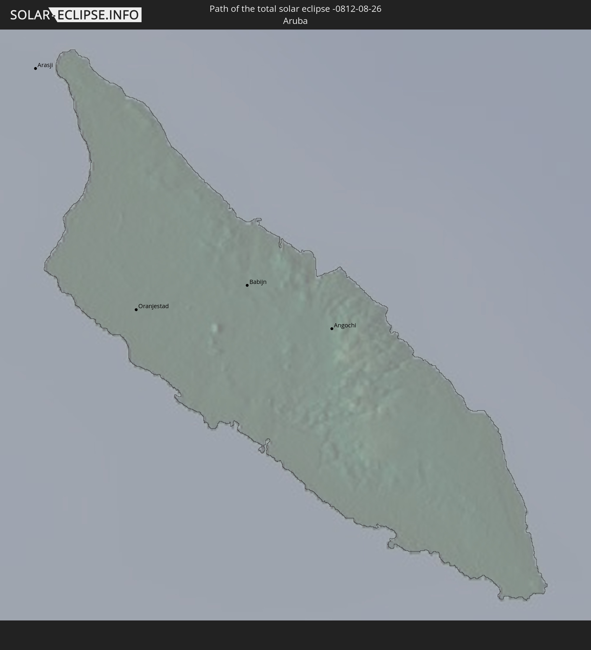
Arasji
|
total | - | 15:00:20 UTC-04:35 | 21 km | 70% |
|
Oranjestad
|
total | - | 15:00:31 UTC-04:35 | 28 km | 68% |
|
Babijn
|
total | - | 15:00:34 UTC-04:35 | 25 km | 68% |
|
Angochi
|
total | - | 15:00:38 UTC-04:35 | 24 km | 68% |
 Sint Michiel Liber
|
total | - | 15:02:29 UTC-04:35 | 9 km | 79% |
|
Willemstad
|
total | - | 15:02:37 UTC-04:35 | 10 km | 74% |
 Kralendijk, Bonaire
|
total | - | 15:03:27 UTC-04:35 | 29 km | 79% |
|
Los Teques, Miranda
|
total | - | 15:15:32 UTC-04:27 | 83 km | 84% |
|
Catia La Mar, Vargas
|
total | - | 15:15:13 UTC-04:27 | 57 km | 80% |
|
San Antonio de Los Altos, Miranda
|
total | - | 15:15:36 UTC-04:27 | 74 km | 90% |
|
Cúa, Miranda
|
total | - | 15:15:58 UTC-04:27 | 93 km | 82% |
|
Caracas, Capital
|
total | - | 15:15:33 UTC-04:27 | 60 km | 86% |
|
Chacao, Miranda
|
total | - | 15:15:34 UTC-04:27 | 58 km | 86% |
|
Los Dos Caminos, Miranda
|
total | - | 15:15:36 UTC-04:27 | 57 km | 88% |
|
El Hatillo, Miranda
|
total | - | 15:15:42 UTC-04:27 | 63 km | 86% |
|
Caucaguita, Miranda
|
total | - | 15:15:49 UTC-04:27 | 69 km | 86% |
|
La Dolorita, Miranda
|
total | - | 15:15:40 UTC-04:27 | 56 km | 88% |
|
Santa Teresa, Miranda
|
total | - | 15:16:09 UTC-04:27 | 74 km | 78% |
|
Guatire, Miranda
|
total | - | 15:15:59 UTC-04:27 | 44 km | 80% |
|
Barcelona, Anzoátegui
|
total | - | 15:18:36 UTC-04:27 | 18 km | 68% |
|
Anaco, Anzoátegui
|
total | - | 15:19:43 UTC-04:27 | 41 km | 76% |
|
El Tigre, Anzoátegui
|
total | - | 15:20:38 UTC-04:27 | 84 km | 84% |
|
Cumaná, Sucre
|
total | - | 15:18:46 UTC-04:27 | 74 km | 58% |
|
San José de Guanipa, Anzoátegui
|
total | - | 15:20:44 UTC-04:27 | 80 km | 84% |
|
Maturín, Monagas
|
total | - | 15:20:44 UTC-04:27 | 55 km | 85% |
|
Ciudad Guayana, Bolívar
|
total | - | 15:22:58 UTC-04:27 | 57 km | 74% |
|
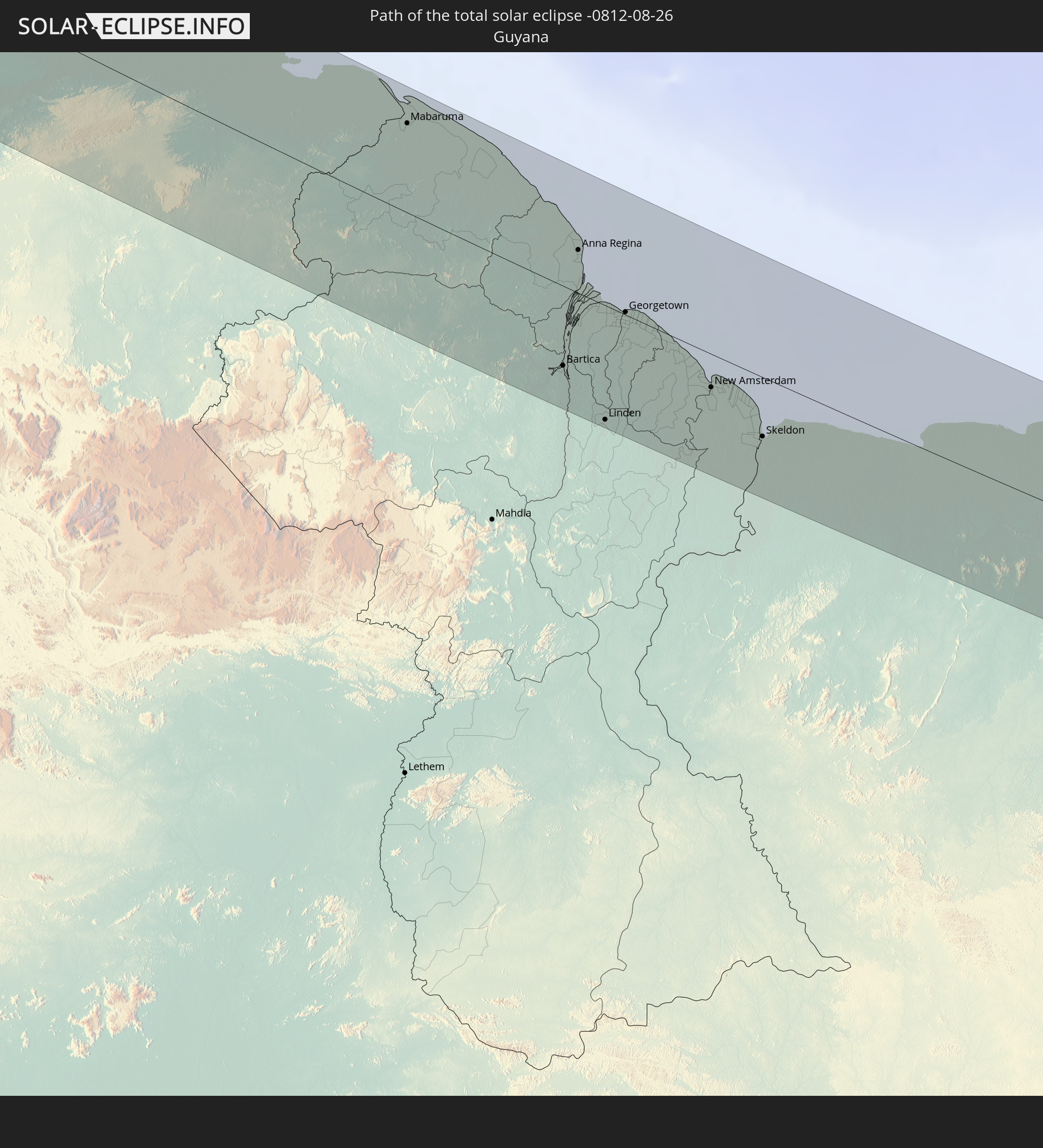
Mabaruma, Barima-Waini
|
total | - | 16:00:51 UTC-03:52 | 66 km | 80% |
|
Bartica, Cuyuni-Mazaruni
|
total | - | 16:03:49 UTC-03:52 | 60 km | 74% |
|
Anna Regina, Pomeroon-Supenaam
|
total | - | 16:02:59 UTC-03:52 | 32 km | 64% |
|
Linden, Upper Demerara-Berbice
|
total | - | 16:04:30 UTC-03:52 | 86 km | 81% |
|
Vreed-en-Hoop, Essequibo Islands-West Demerara
|
total | - | 16:03:44 UTC-03:52 | 1 km | 76% |
|
Georgetown, Demerara-Mahaica
|
total | - | 16:03:46 UTC-03:52 | 2 km | 76% |
|
Fort Wellington, Mahaica-Berbice
|
total | - | 16:04:39 UTC-03:52 | 14 km | 44% |
|
Rosignol, Mahaica-Berbice
|
total | - | 16:04:49 UTC-03:52 | 24 km | 60% |
|
New Amsterdam, East Berbice-Corentyne
|
total | - | 16:04:52 UTC-03:52 | 25 km | 66% |
|
Skeldon, East Berbice-Corentyne
|
total | - | 16:05:32 UTC-03:52 | 45 km | 61% |
|
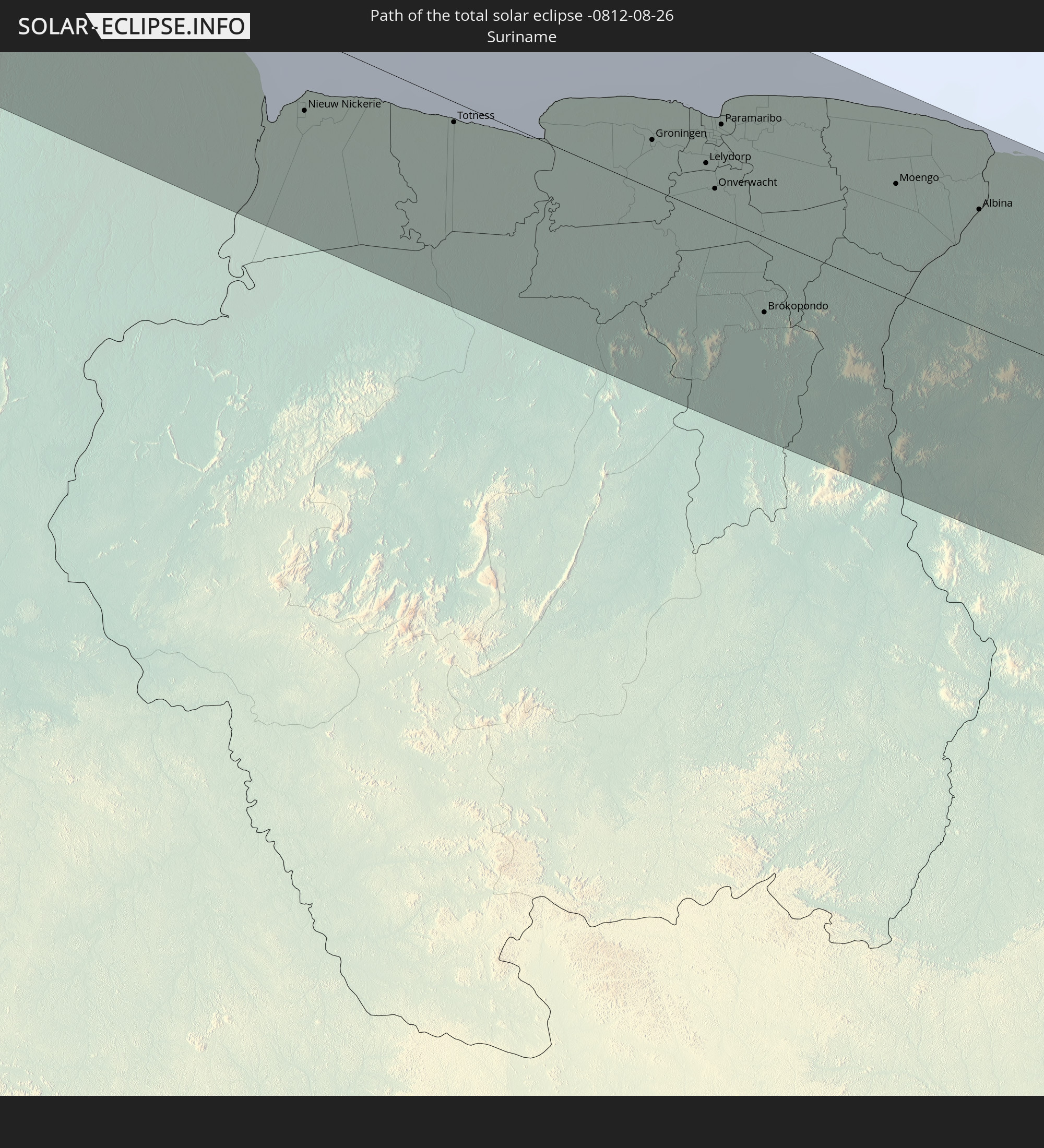
Nieuw Nickerie, Nickerie
|
total | - | 16:17:36 UTC-03:40 | 33 km | 60% |
|
Totness, Coronie
|
total | - | 16:18:08 UTC-03:40 | 9 km | 48% |
|
Groningen, Saramacca
|
total | - | 16:18:48 UTC-03:40 | 21 km | 57% |
|
Lelydorp, Wanica
|
total | - | 16:19:03 UTC-03:40 | 22 km | 58% |
|
Onverwacht, Para
|
total | - | 16:19:12 UTC-03:40 | 12 km | 58% |
|
Paramaribo, Paramaribo
|
total | - | 16:18:56 UTC-03:40 | 41 km | 66% |
|
Nieuw Amsterdam, Commewijne
|
total | - | 16:18:58 UTC-03:40 | 47 km | 60% |
|
Brokopondo, Brokopondo
|
total | - | 16:19:51 UTC-03:40 | 33 km | 54% |
|
Moengo, Marowijne
|
total | - | 16:19:41 UTC-03:40 | 48 km | 62% |
|
Albina, Marowijne
|
total | - | 16:20:01 UTC-03:40 | 53 km | 56% |
|
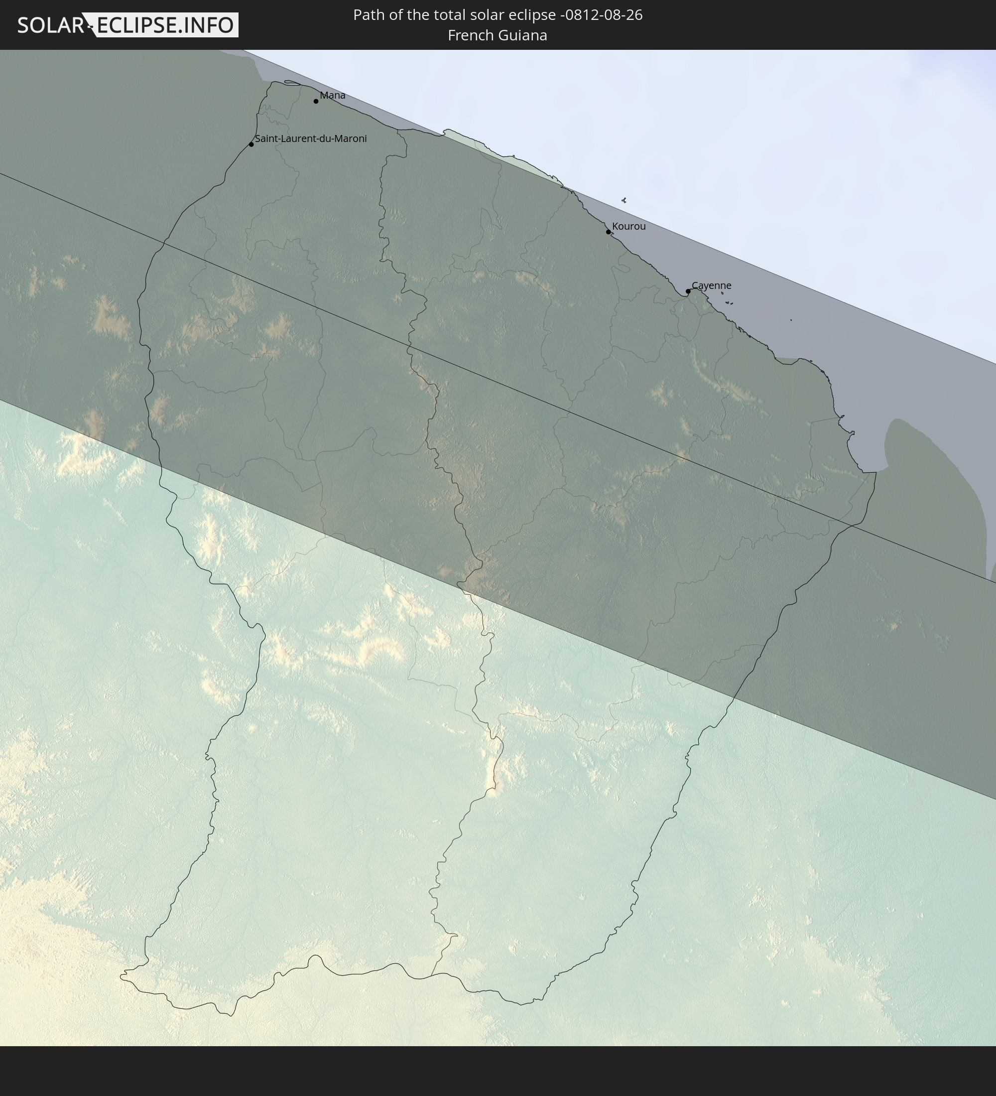
Saint-Laurent-du-Maroni, Guyane
|
total | - | 16:31:22 UTC-03:29 | 54 km | 61% |
|
Mana, Guyane
|
total | - | 16:31:21 UTC-03:29 | 82 km | 47% |
|
Kourou, Guyane
|
total | - | 16:32:30 UTC-03:29 | 78 km | 38% |
|
Macouria, Guyane
|
total | - | 16:32:53 UTC-03:29 | 63 km | 62% |
|
Cayenne, Guyane
|
total | - | 16:32:53 UTC-03:29 | 67 km | 50% |
|
Matoury, Guyane
|
total | - | 16:32:58 UTC-03:29 | 59 km | 68% |
|
Rémire-Montjoly, Guyane
|
total | - | 16:32:57 UTC-03:29 | 68 km | 50% |