Total solar eclipse of 04/13/-0824
| Day of week: | Monday |
| Maximum duration of eclipse: | 05m49s |
| Maximum width of eclipse path: | 282 km |
| Saros cycle: | 35 |
| Coverage: | 100% |
| Magnitude: | 1.0747 |
| Gamma: | -0.5315 |
Wo kann man die Sonnenfinsternis vom 04/13/-0824 sehen?
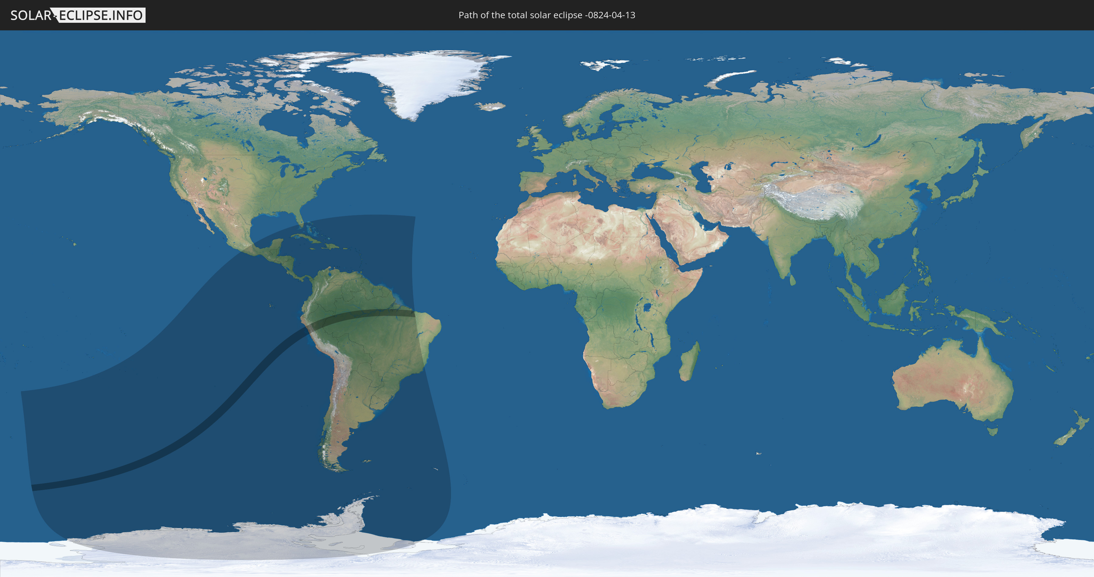
Die Sonnenfinsternis am 04/13/-0824 kann man in 53 Ländern als partielle Sonnenfinsternis beobachten.
Der Finsternispfad verläuft durch 3 Länder. Nur in diesen Ländern ist sie als total Sonnenfinsternis zu sehen.
In den folgenden Ländern ist die Sonnenfinsternis total zu sehen
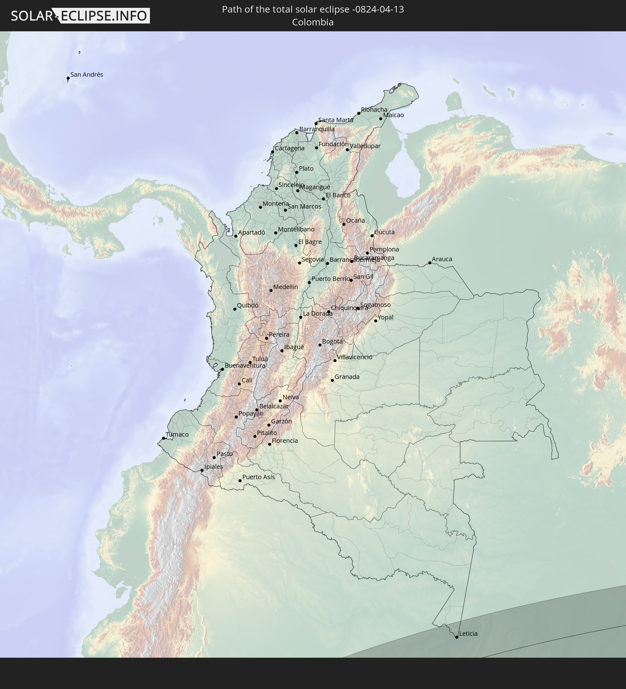 Colombia
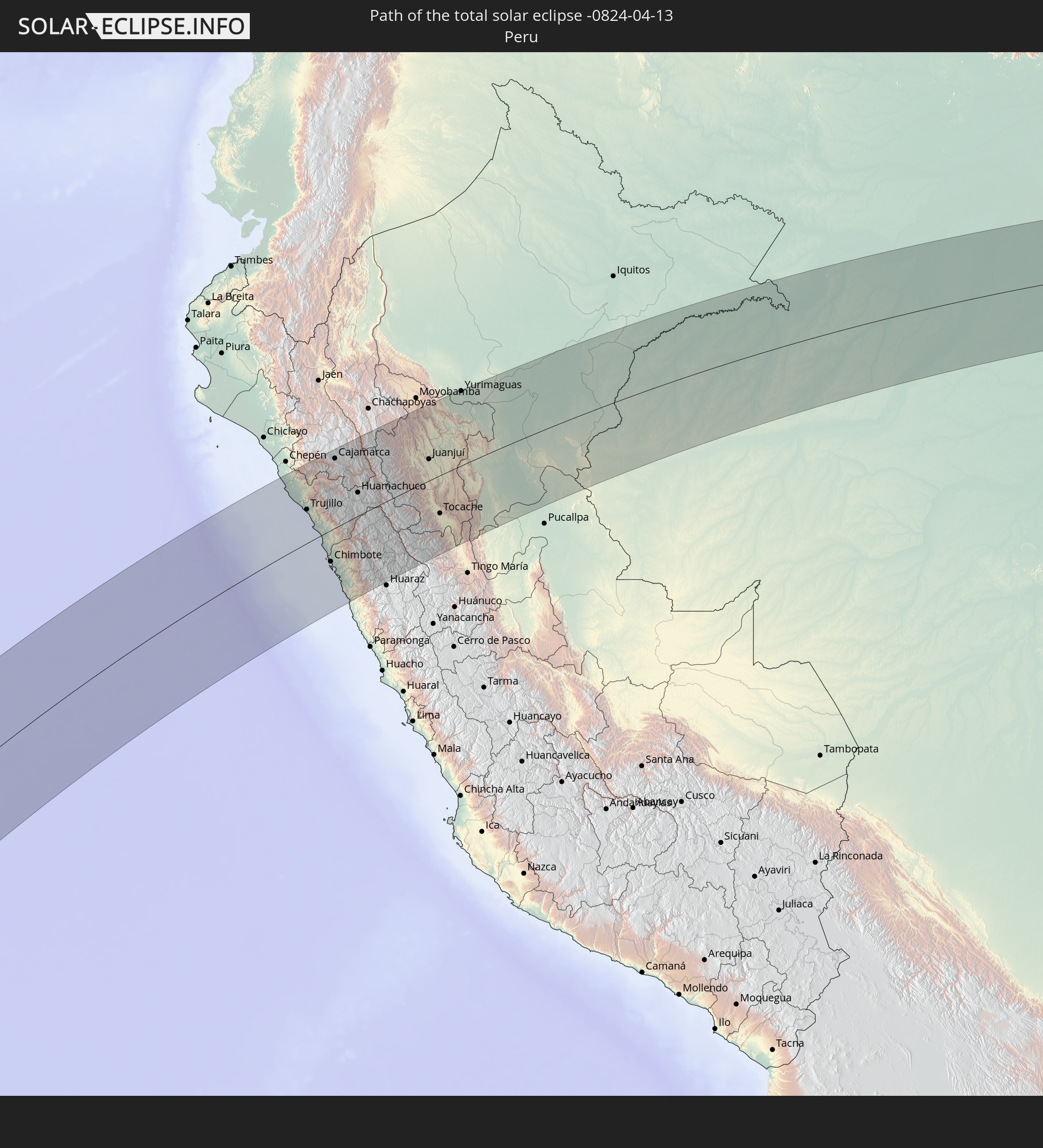 Peru
Peru
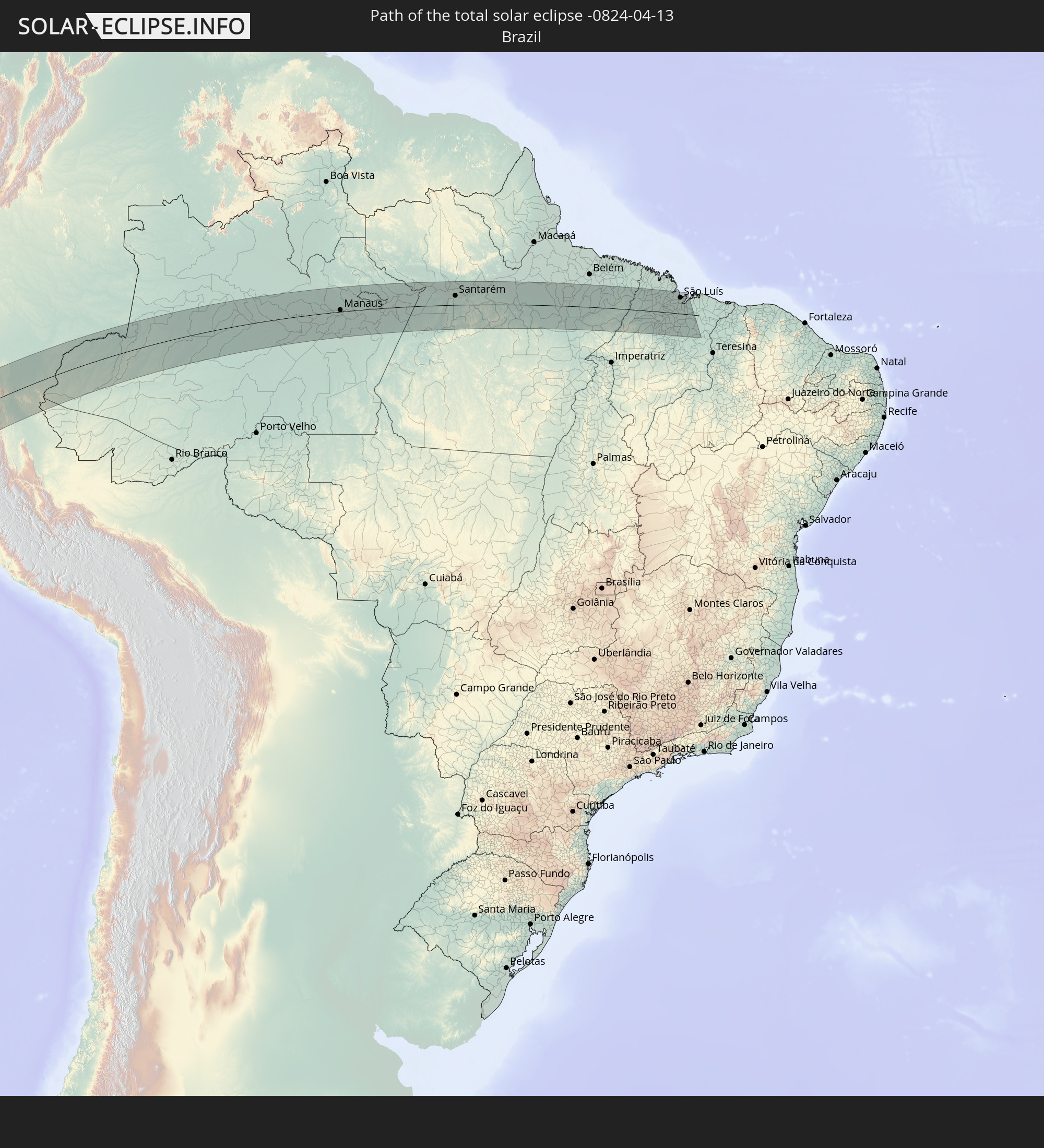 Brazil
In den folgenden Ländern ist die Sonnenfinsternis partiell zu sehen
 Antarctica
 United States
 United States Minor Outlying Islands
 French Polynesia
 Pitcairn Islands
 Mexico
 Chile
Chile
 Guatemala
 Ecuador
 El Salvador
 Honduras
 Belize
 Nicaragua
 Costa Rica
 Cuba
Cuba
 Panama
 Colombia
 Cayman Islands
 Peru
Peru
 The Bahamas
 Jamaica
 Haiti
Haiti
 Brazil
 Argentina
 Venezuela
 Turks and Caicos Islands
 Dominican Republic
 Aruba
Aruba
 Bolivia
 Puerto Rico
 United States Virgin Islands
 British Virgin Islands
 Anguilla
 Collectivity of Saint Martin
 Saint Barthélemy
 Saint Kitts and Nevis
 Paraguay
 Antigua and Barbuda
 Montserrat
 Trinidad and Tobago
 Guadeloupe
 Grenada
 Dominica
 Saint Vincent and the Grenadines
 Falkland Islands
 Guyana
 Martinique
 Saint Lucia
 Barbados
 Uruguay
 Suriname
 French Guiana
 South Georgia and the South Sandwich Islands
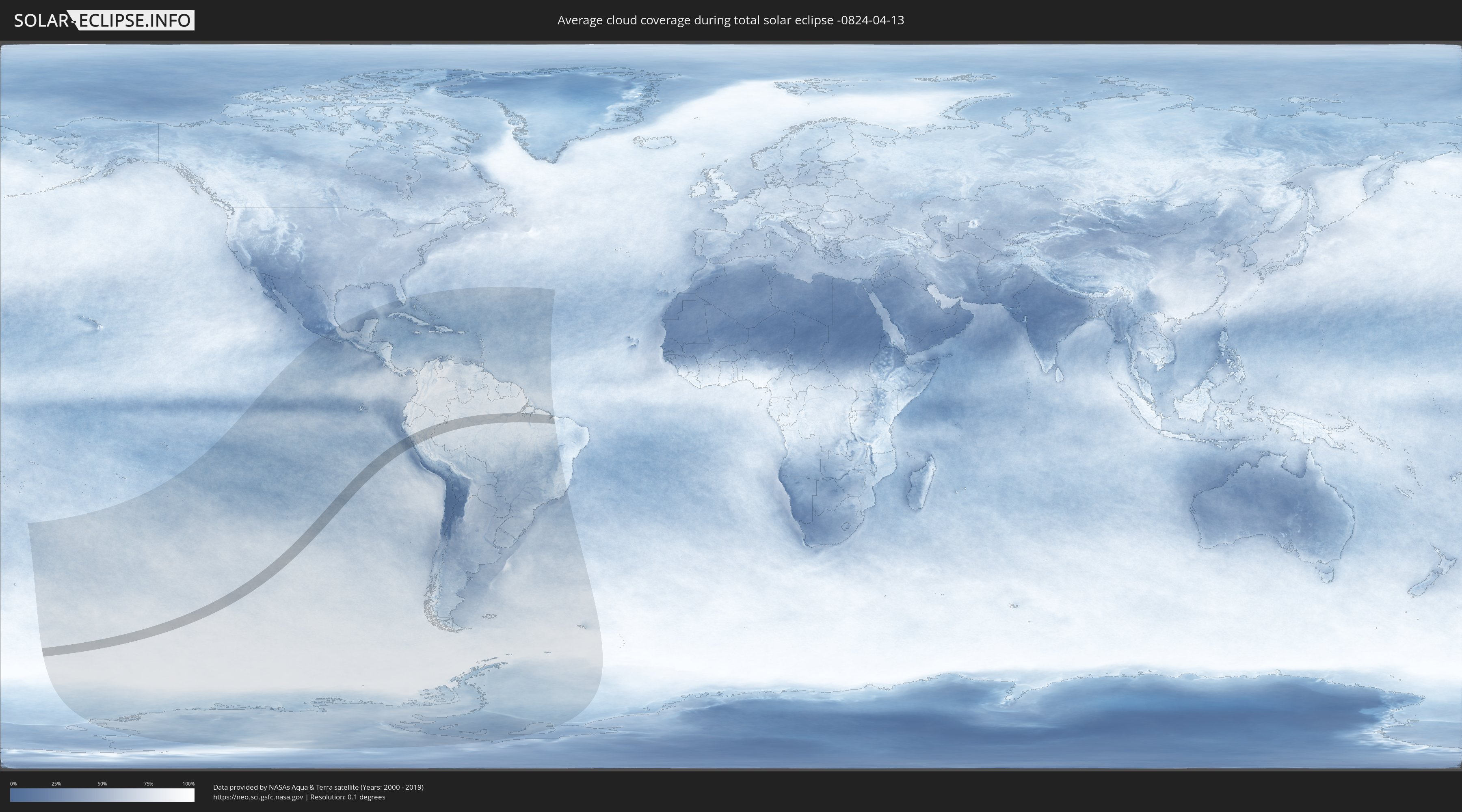
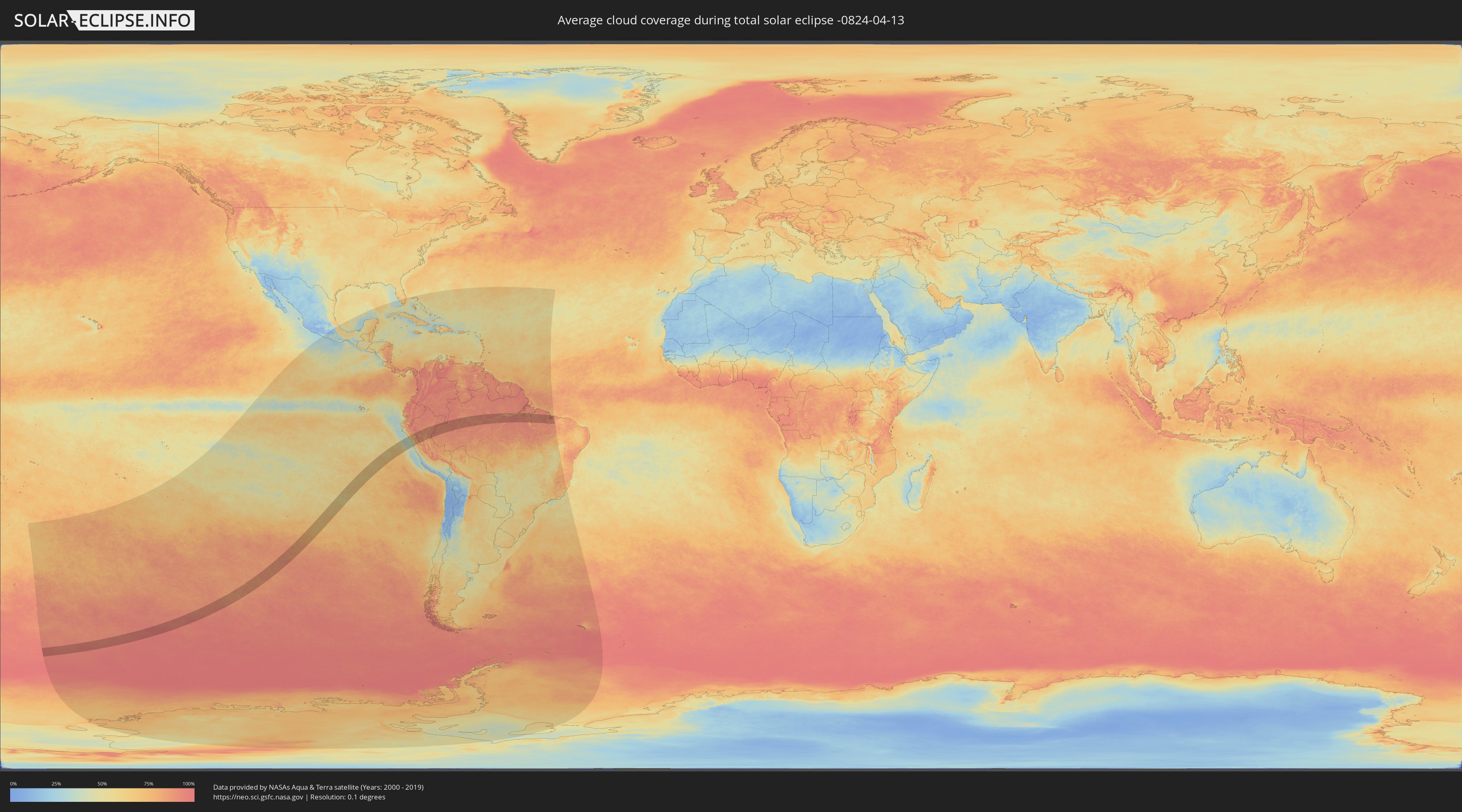
How will be the weather during the total solar eclipse on 04/13/-0824?
Where is the best place to see the total solar eclipse of 04/13/-0824?
The following maps show the average cloud coverage for the day of the total solar eclipse.
With the help of these maps, it is possible to find the place along the eclipse path, which has the best
chance of a cloudless sky.
Nevertheless, you should consider local circumstances and inform about the weather of your chosen
observation site.
The data is provided by NASAs satellites
AQUA and TERRA.
The cloud maps are averaged over a period of 19 years (2000 - 2019).
Detailed country maps
 Colombia
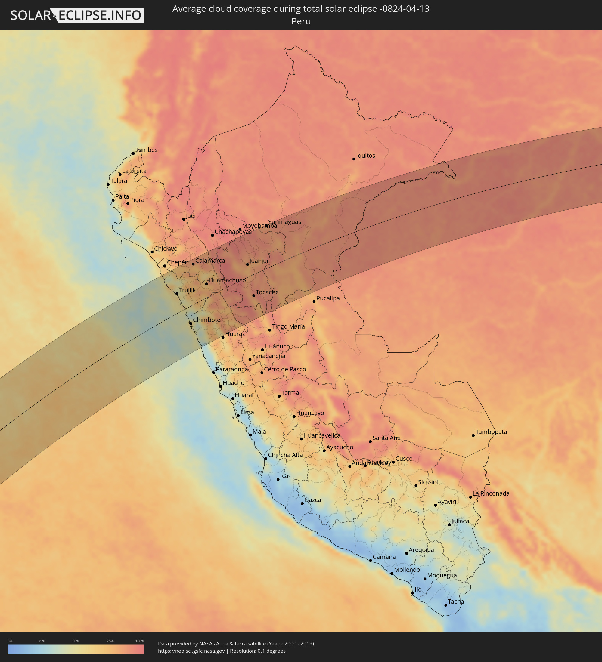 Peru
Peru
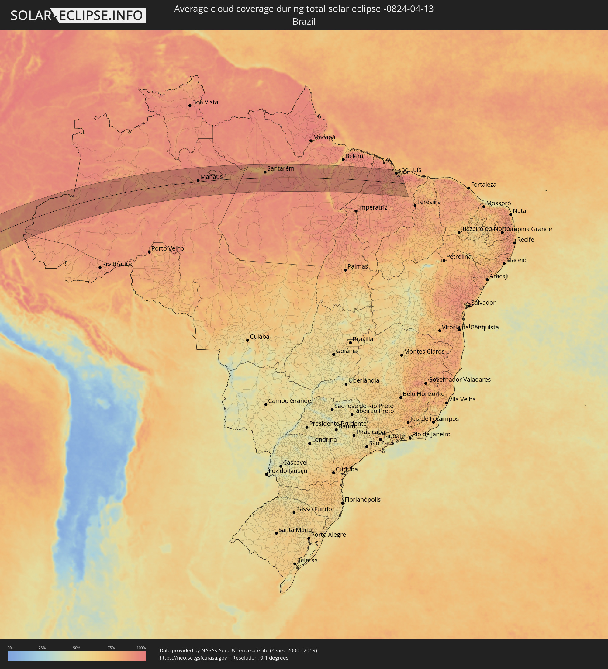 Brazil
Cities inside the path of the eclipse
The following table shows all locations with a population of more than 5,000 inside the eclipse path. Cities which have more than 100,000 inhabitants are marked bold. A click at the locations opens a detailed map.
| City | Type | Eclipse duration | Local time of max. eclipse | Distance to central line | Ø Cloud coverage |
|
Paiján, La Libertad
|
total | - | 15:12:27 UTC-05:08 | 113 km | 66% |
|
Santiago de Cao, La Libertad
|
total | - | 15:12:09 UTC-05:08 | 88 km | 57% |
|
Chocope, La Libertad
|
total | - | 15:12:28 UTC-05:08 | 103 km | 64% |
|
Chicama, La Libertad
|
total | - | 15:12:29 UTC-05:08 | 94 km | 51% |
|
Ascope, La Libertad
|
total | - | 15:12:45 UTC-05:08 | 105 km | 57% |
|
Trujillo, La Libertad
|
total | - | 15:12:11 UTC-05:08 | 61 km | 61% |
|
Moche, La Libertad
|
total | - | 15:12:08 UTC-05:08 | 55 km | 53% |
|
Salaverry, La Libertad
|
total | - | 15:12:05 UTC-05:08 | 48 km | 53% |
|
Laredo, La Libertad
|
total | - | 15:12:20 UTC-05:08 | 60 km | 61% |
|
Virú, La Libertad
|
total | - | 15:12:05 UTC-05:08 | 17 km | 59% |
|
Puerto Santa, Ancash
|
total | - | 15:11:16 UTC-05:08 | 44 km | 55% |
|
Coishco, Ancash
|
total | - | 15:11:15 UTC-05:08 | 49 km | 55% |
|
Otuzco, La Libertad
|
total | - | 15:13:12 UTC-05:08 | 59 km | 70% |
|
Chimbote, Ancash
|
total | - | 15:11:12 UTC-05:08 | 57 km | 53% |
|
Cajamarca, Cajamarca
|
total | - | 15:14:32 UTC-05:08 | 128 km | 76% |
|
Quiruvilca, La Libertad
|
total | - | 15:13:37 UTC-05:08 | 33 km | 74% |
|
Santiago de Chuco, La Libertad
|
total | - | 15:13:22 UTC-05:08 | 15 km | 65% |
|
Celendín, Cajamarca
|
total | - | 15:15:31 UTC-05:08 | 140 km | 82% |
|
Huamachuco, La Libertad
|
total | - | 15:14:05 UTC-05:08 | 43 km | 76% |
|
Cajabamba, Cajamarca
|
total | - | 15:14:25 UTC-05:08 | 60 km | 70% |
|
Carás, Ancash
|
total | - | 15:12:22 UTC-05:08 | 93 km | 57% |
|
Yungay, Ancash
|
total | - | 15:12:18 UTC-05:08 | 106 km | 59% |
|
Carhuaz, Ancash
|
total | - | 15:12:12 UTC-05:08 | 125 km | 55% |
|
Yauya, Ancash
|
total | - | 15:13:12 UTC-05:08 | 113 km | 80% |
|
Huicungo, San Martín
|
total | - | 15:16:40 UTC-05:08 | 28 km | 78% |
|
Saposoa, San Martín
|
total | - | 15:17:17 UTC-05:08 | 67 km | 81% |
|
Juanjuí, San Martín
|
total | - | 15:16:57 UTC-05:08 | 40 km | 76% |
|
Sisa, San Martín
|
total | - | 15:17:55 UTC-05:08 | 96 km | 86% |
|
Tabalosos, San Martín
|
total | - | 15:18:21 UTC-05:08 | 122 km | 90% |
|
Bellavista, San Martín
|
total | - | 15:17:20 UTC-05:08 | 46 km | 83% |
|
Lamas, San Martín
|
total | - | 15:18:26 UTC-05:08 | 108 km | 87% |
|
Tocache, San Martín
|
total | - | 15:15:36 UTC-05:08 | 71 km | 76% |
|
Uchiza, San Martín
|
total | - | 15:15:14 UTC-05:08 | 101 km | 85% |
|
Picota, San Martín
|
total | - | 15:17:54 UTC-05:08 | 48 km | 80% |
|
Chazuta, San Martín
|
total | - | 15:18:43 UTC-05:08 | 74 km | 88% |
|
Yurimaguas, Loreto
|
total | - | 15:19:48 UTC-05:08 | 142 km | 86% |
|
Contamana, Loreto
|
total | - | 15:18:59 UTC-05:08 | 53 km | 80% |
|
Benjamin Constant, Amazonas
|
total | - | 16:35:14 UTC-04:02 | 73 km | 88% |
|
Ramón Castilla, Loreto
|
total | - | 15:29:33 UTC-05:08 | 83 km | 84% |
|
Leticia, Amazonas
|
total | - | 16:35:33 UTC-04:02 | 87 km | 87% |
|
Tabatinga, Amazonas
|
total | - | 16:35:32 UTC-04:02 | 85 km | 87% |
|
Jutaí, Amazonas
|
total | - | 16:35:19 UTC-04:02 | 47 km | 90% |
|
Carauari, Amazonas
|
total | - | 16:37:44 UTC-04:02 | 68 km | 83% |
|
Tefé, Amazonas
|
total | - | 16:41:39 UTC-04:02 | 50 km | 88% |
|
Coari, Amazonas
|
total | - | 16:42:04 UTC-04:02 | 57 km | 88% |
|
Codajás, Amazonas
|
total | - | 16:43:13 UTC-04:02 | 47 km | 85% |
|
Anori, Amazonas
|
total | - | 16:43:36 UTC-04:02 | 46 km | 88% |
|
Manacapuru, Amazonas
|
total | - | 16:44:54 UTC-04:02 | 7 km | 86% |
|
Manaquiri, Amazonas
|
total | - | 16:45:04 UTC-04:02 | 12 km | 86% |
|
Iranduba, Amazonas
|
total | - | 16:45:13 UTC-04:02 | 10 km | 87% |
|
Manaus, Amazonas
|
total | - | 16:45:32 UTC-04:02 | 9 km | 90% |
|
Careiro da Várzea, Amazonas
|
total | - | 16:45:33 UTC-04:02 | 4 km | 84% |
|
Rio Preto da Eva, Amazonas
|
total | - | 16:46:12 UTC-04:02 | 50 km | 95% |
|
Autazes, Amazonas
|
total | - | 16:45:34 UTC-04:02 | 53 km | 90% |
|
Nova Olinda do Norte, Amazonas
|
total | - | 16:45:14 UTC-04:02 | 88 km | 90% |
|
Itacoatiara, Amazonas
|
total | - | 16:46:29 UTC-04:02 | 11 km | 87% |
|
Urucurituba, Amazonas
|
total | - | 16:46:40 UTC-04:02 | 12 km | 90% |
|
Urucará, Amazonas
|
total | - | 16:47:33 UTC-04:02 | 51 km | 86% |
|
Maués, Amazonas
|
total | - | 16:46:39 UTC-04:02 | 43 km | 88% |
|
Guajará, Amazonas
|
total | - | 16:47:08 UTC-04:02 | 3 km | 88% |
|
Barreirinha, Amazonas
|
total | - | 16:47:40 UTC-04:02 | 18 km | 87% |
|
Parintins, Amazonas
|
total | - | 16:48:01 UTC-04:02 | 34 km | 89% |
|
Nhamundá, Amazonas
|
total | - | 16:48:30 UTC-04:02 | 84 km | 81% |
|
Terra Santa, Pará
|
total | - | 17:37:27 UTC-03:13 | 91 km | 82% |
|
Juruti, Pará
|
total | - | 17:37:36 UTC-03:13 | 84 km | 90% |
|
Ábidos, Pará
|
total | - | 17:38:07 UTC-03:13 | 108 km | 80% |
|
Alenquer, Pará
|
total | - | 17:38:27 UTC-03:13 | 103 km | 86% |
|
Santarém, Pará
|
total | - | 17:37:57 UTC-03:13 | 47 km | 85% |
|
Monte Alegre, Pará
|
total | - | 17:38:41 UTC-03:13 | 95 km | 82% |
|
Prainha, Pará
|
total | - | 17:39:08 UTC-03:13 | 117 km | 78% |
|
Altamira, Pará
|
total | - | 17:38:13 UTC-03:13 | 39 km | 88% |
|
Senador José Porfírio, Pará
|
total | - | 17:38:56 UTC-03:13 | 29 km | 85% |
|
Portel, Pará
|
total | - | 17:39:57 UTC-03:13 | 105 km | 81% |
|
Oeiras do Pará, Pará
|
total | - | 17:40:10 UTC-03:13 | 100 km | 85% |
|
Tucuruí, Pará
|
total | - | 17:38:30 UTC-03:13 | 95 km | 77% |
|
Baião, Pará
|
total | - | 17:39:28 UTC-03:13 | 13 km | 81% |
|
Mocajuba, Pará
|
total | - | 17:39:43 UTC-03:13 | 37 km | 86% |
|
Cametá, Pará
|
total | - | 17:40:03 UTC-03:13 | 75 km | 80% |
|
Igarapé Miri, Pará
|
total | - | 17:40:26 UTC-03:13 | 107 km | 87% |
|
Acará, Pará
|
total | - | 17:40:38 UTC-03:13 | 113 km | 86% |
|
Tomé Açu, Pará
|
total | - | 17:40:13 UTC-03:13 | 63 km | 90% |
|
Paragominas, Pará
|
total | - | 17:39:51 UTC-03:13 | 6 km | 90% |
|
Santa Inês, Maranhão
|
total | - | 18:19:31 UTC-02:34 | 55 km | 92% |
|
Pindaré Mirim, Maranhão
|
total | - | 18:19:34 UTC-02:34 | 48 km | 88% |
|
Santa Helena, Maranhão
|
total | - | 18:20:50 UTC-02:34 | 105 km | 90% |
|
Monção, Maranhão
|
total | - | 18:19:42 UTC-02:34 | 34 km | 82% |
|
Vitorino Freire, Maranhão
|
total | - | 18:19:11 UTC-02:34 | 95 km | 93% |
|
Paulo Ramos, Maranhão
|
total | - | 18:19:01 UTC-02:34 | 114 km | 93% |
|
Penalva, Maranhão
|
total | - | 18:19:53 UTC-02:34 | 11 km | 78% |
|
Pio XII, Maranhão
|
total | - | 18:19:23 UTC-02:34 | 71 km | 86% |
|
Pinheiro, Maranhão
|
total | - | 18:20:36 UTC-02:34 | 75 km | 87% |
|
Matinha, Maranhão
|
total | - | 18:20:05 UTC-02:34 | 11 km | 84% |
|
Viana, Maranhão
|
total | - | 18:19:59 UTC-02:34 | 2 km | 87% |
|
Vitória do Mearim, Maranhão
|
total | - | 18:19:46 UTC-02:34 | 27 km | 87% |
|
São Bento, Maranhão
|
total | - | 18:20:29 UTC-02:34 | 58 km | 90% |
|
Arari, Maranhão
|
total | - | 18:19:48 UTC-02:34 | 25 km | 85% |
|
São Mateus do Maranhão, Maranhão
|
total | - | 18:19:17 UTC-02:34 | 88 km | 88% |
|
Cantanhede, Maranhão
|
total | - | 18:19:41 UTC-02:34 | 41 km | 87% |
|
Itapecuru Mirim, Maranhão
|
total | - | 18:19:54 UTC-02:34 | 14 km | 88% |
|
São Luís, Maranhão
|
total | - | 18:20:41 UTC-02:34 | 82 km | 91% |
|
Pirapemas, Maranhão
|
total | - | 18:19:37 UTC-02:34 | 50 km | 84% |
|
Coroatá, Maranhão
|
total | - | 18:19:15 UTC-02:34 | 94 km | 89% |
|
São José de Ribamar, Maranhão
|
total | - | 18:20:41 UTC-02:34 | 81 km | 86% |
|
Timbiras, Maranhão
|
total | - | 18:19:09 UTC-02:34 | 106 km | 85% |
|
Vargem Grande, Maranhão
|
total | - | 18:19:49 UTC-02:34 | 26 km | 87% |
|
Santa Rita, Maranhão
|
total | - | 18:19:32 UTC-02:34 | 61 km | 84% |