Annular solar eclipse of 12/28/-0875
| Day of week: | Sunday |
| Maximum duration of eclipse: | 06m49s |
| Maximum width of eclipse path: | 260 km |
| Saros cycle: | 37 |
| Coverage: | 93.5% |
| Magnitude: | 0.9352 |
| Gamma: | -0.3725 |
Wo kann man die Sonnenfinsternis vom 12/28/-0875 sehen?
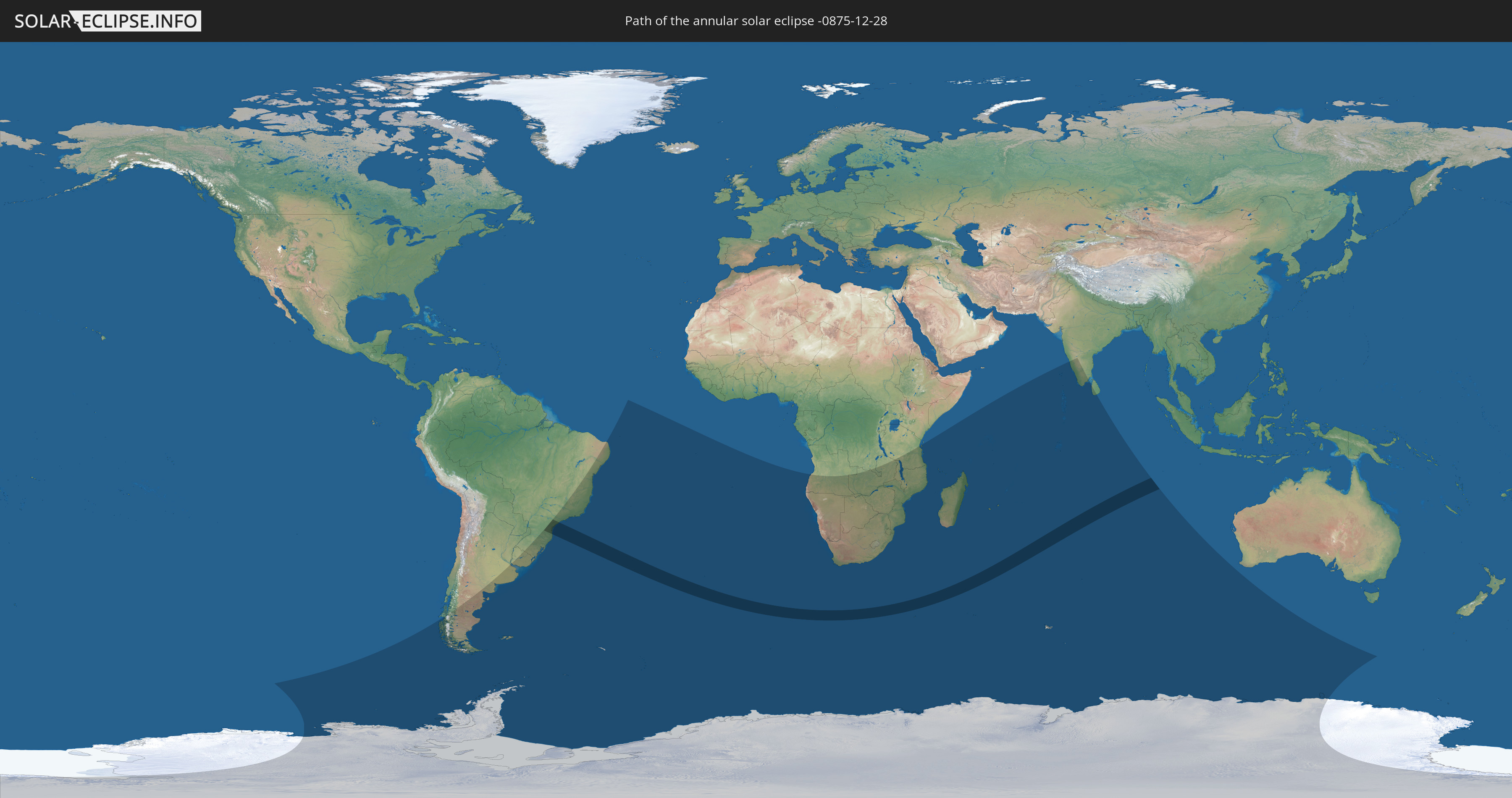
Die Sonnenfinsternis am 12/28/-0875 kann man in 33 Ländern als partielle Sonnenfinsternis beobachten.
Der Finsternispfad verläuft durch ein Land. Nur in diesem Land ist sie als annular Sonnenfinsternis zu sehen.
In den folgenden Ländern ist die Sonnenfinsternis annular zu sehen
 Brazil
In den folgenden Ländern ist die Sonnenfinsternis partiell zu sehen
 Antarctica
 Chile
Chile
 Brazil
 Argentina
 Falkland Islands
 Uruguay
 South Georgia and the South Sandwich Islands
 Saint Helena, Ascension and Tristan da Cunha
 Bouvet Island
 Angola
 Namibia
 Democratic Republic of the Congo
 South Africa
 Botswana
 Zambia
 Zimbabwe
 Lesotho
 Tanzania
 Mozambique
 Swaziland
 Malawi
 French Southern and Antarctic Lands
 Madagascar
 Comoros
 Mayotte
 Seychelles
 Réunion
 Mauritius
 India
India
 British Indian Ocean Territory
 Heard Island and McDonald Islands
 Maldives
 Sri Lanka
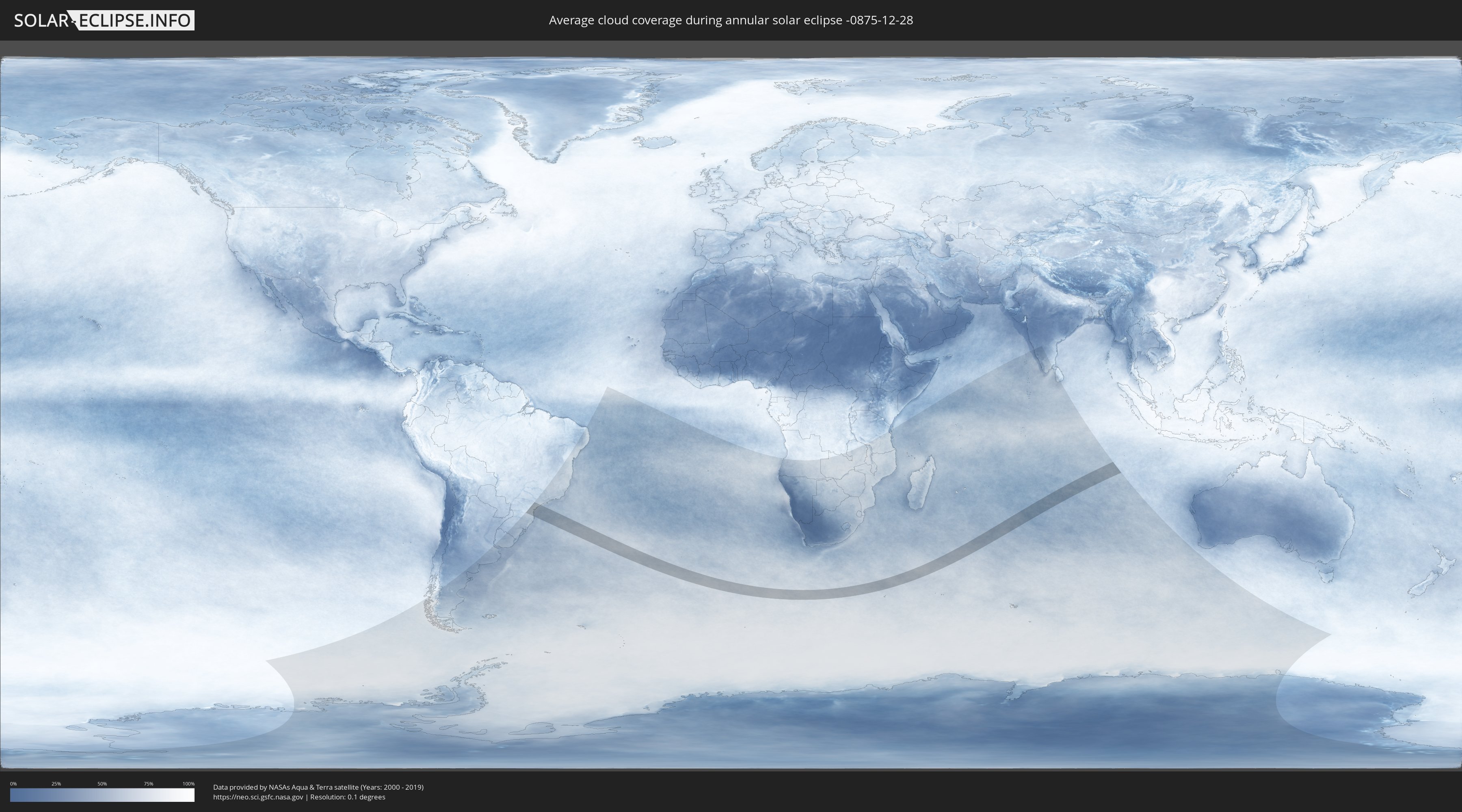
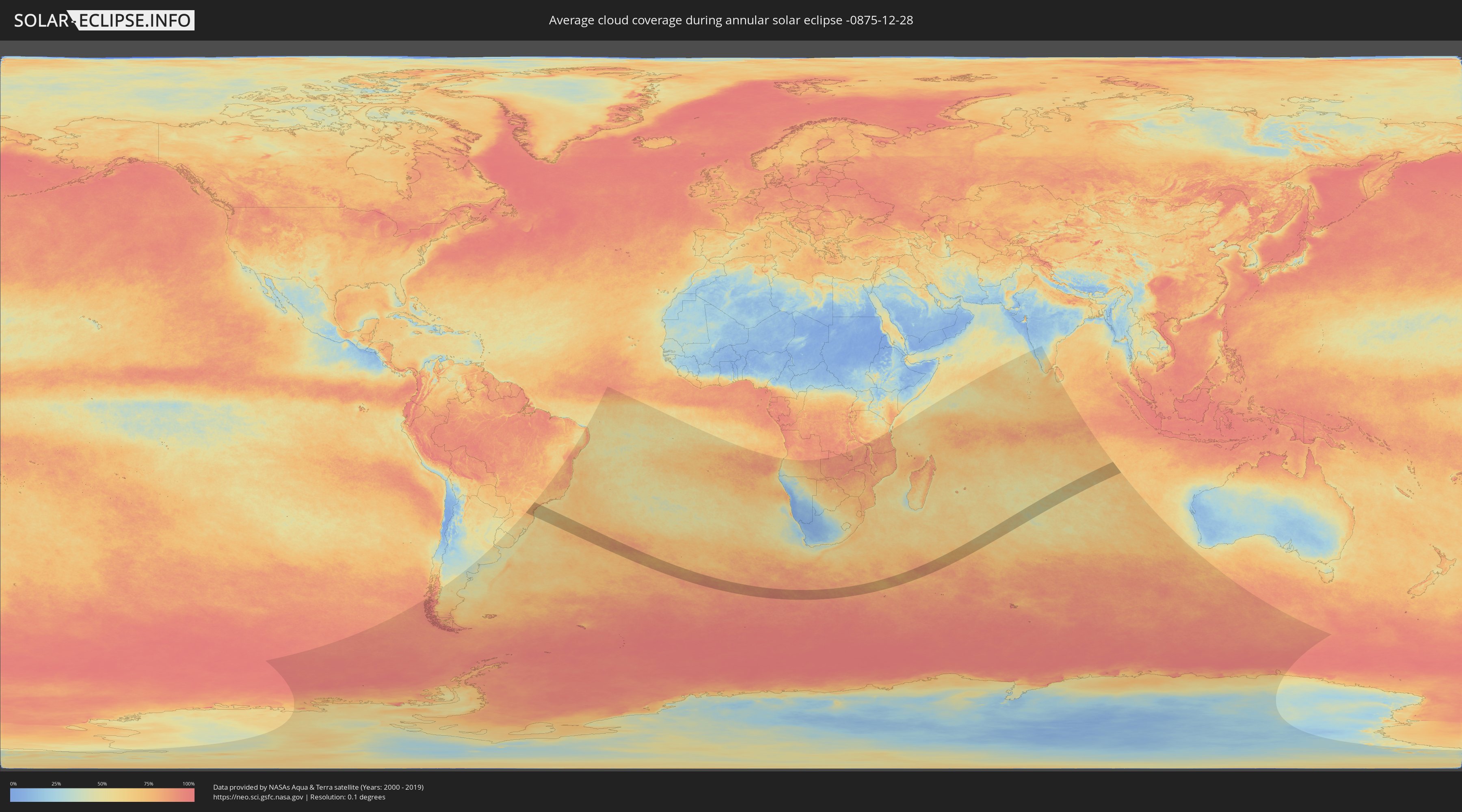
How will be the weather during the annular solar eclipse on 12/28/-0875?
Where is the best place to see the annular solar eclipse of 12/28/-0875?
The following maps show the average cloud coverage for the day of the annular solar eclipse.
With the help of these maps, it is possible to find the place along the eclipse path, which has the best
chance of a cloudless sky.
Nevertheless, you should consider local circumstances and inform about the weather of your chosen
observation site.
The data is provided by NASAs satellites
AQUA and TERRA.
The cloud maps are averaged over a period of 19 years (2000 - 2019).
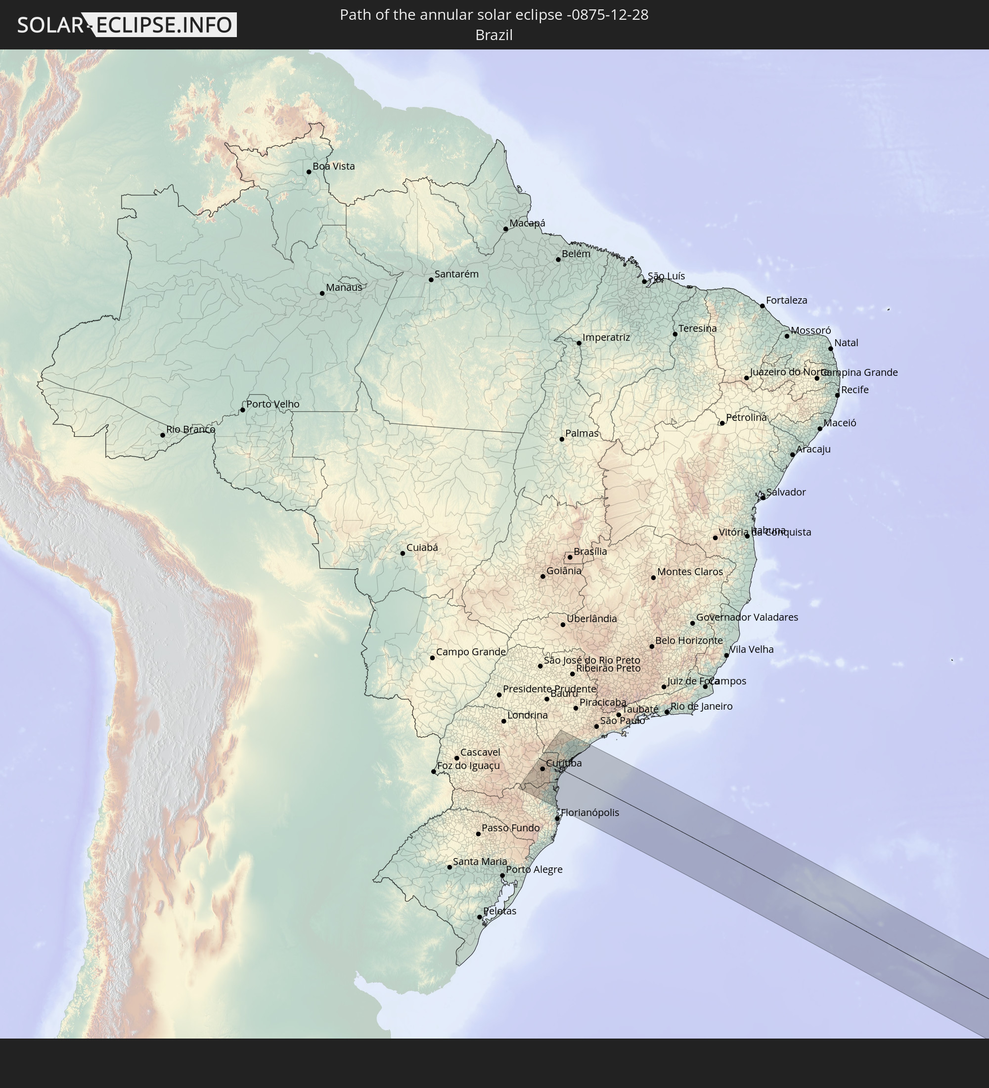
Detailed country maps
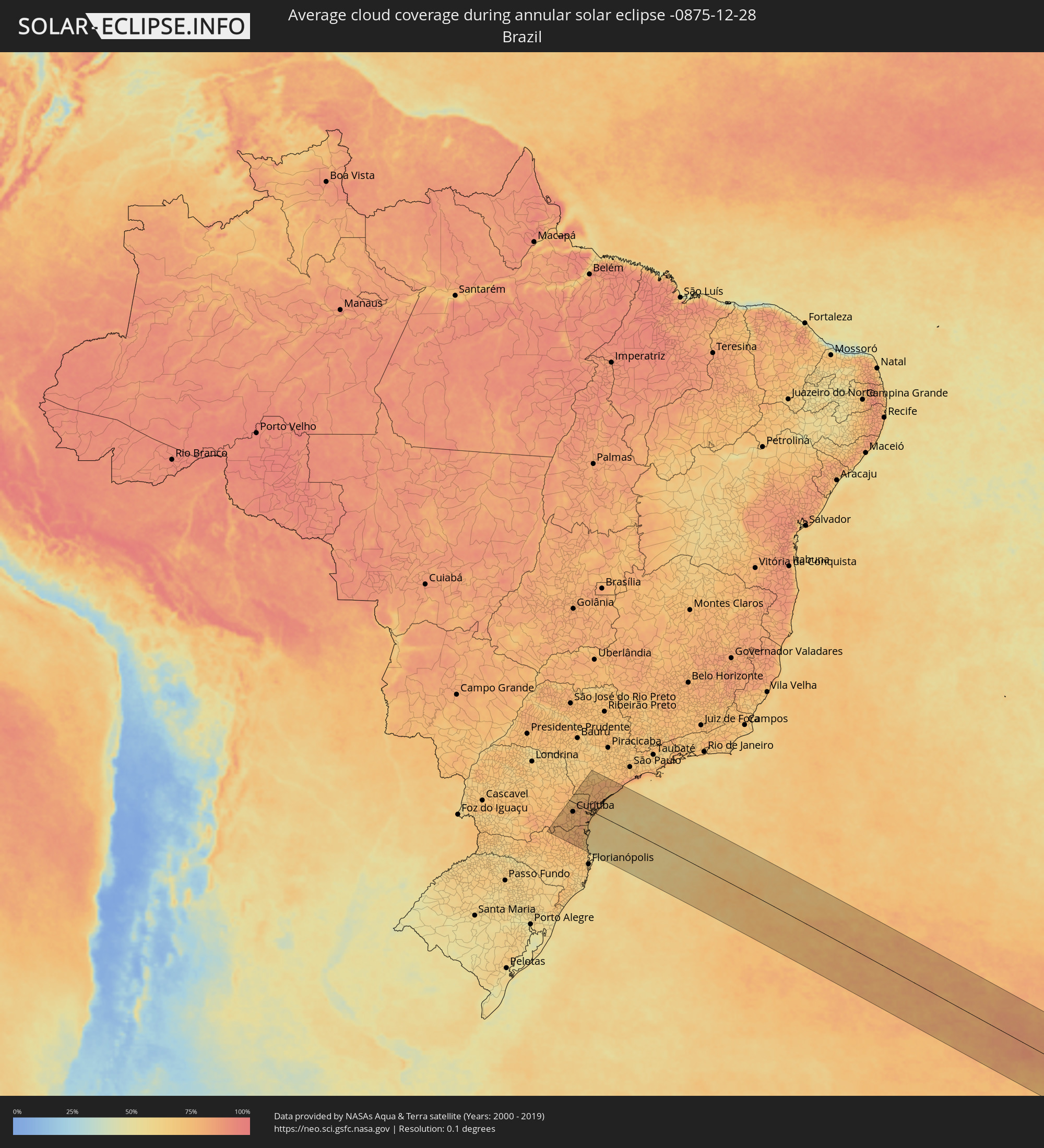 Brazil
Cities inside the path of the eclipse
The following table shows all locations with a population of more than 5,000 inside the eclipse path. Cities which have more than 100,000 inhabitants are marked bold. A click at the locations opens a detailed map.
| City | Type | Eclipse duration | Local time of max. eclipse | Distance to central line | Ø Cloud coverage |
|
Canoinhas, Santa Catarina
|
annular | - | 05:30:51 UTC-03:06 | 166 km | 74% |
|
Três Barras, Santa Catarina
|
annular | - | 05:30:46 UTC-03:06 | 156 km | 77% |
|
Mafra, Santa Catarina
|
annular | - | 05:30:34 UTC-03:06 | 132 km | 76% |
|
Rio Negro, Paraná
|
annular | - | 05:30:33 UTC-03:06 | 132 km | 76% |
|
Lapa, Paraná
|
annular | - | 05:30:13 UTC-03:06 | 94 km | 77% |
|
Campo Largo, Paraná
|
annular | - | 05:29:52 UTC-03:06 | 55 km | 76% |
|
Rio Negrinho, Santa Catarina
|
annular | - | 05:30:35 UTC-03:06 | 134 km | 76% |
|
Araucária, Paraná
|
annular | - | 05:29:56 UTC-03:06 | 63 km | 77% |
|
São Bento do Sul, Santa Catarina
|
annular | - | 05:30:31 UTC-03:06 | 127 km | 77% |
|
Itaperuçu, Paraná
|
annular | - | 05:29:35 UTC-03:06 | 23 km | 75% |
|
Rio Branco do Sul, Paraná
|
annular | - | 05:29:32 UTC-03:06 | 19 km | 75% |
|
Almirante Tamandaré, Paraná
|
annular | - | 05:29:39 UTC-03:06 | 32 km | 77% |
|
Curitiba, Paraná
|
annular | - | 05:29:44 UTC-03:06 | 40 km | 79% |
|
Corupá, Santa Catarina
|
annular | - | 05:30:38 UTC-03:06 | 138 km | 77% |
|
Colombo, Paraná
|
annular | - | 05:29:36 UTC-03:06 | 25 km | 78% |
|
São José dos Pinhais, Paraná
|
annular | - | 05:29:48 UTC-03:06 | 48 km | 76% |
|
Pinhais, Paraná
|
annular | - | 05:29:43 UTC-03:06 | 39 km | 78% |
|
Pomerode, Santa Catarina
|
annular | - | 05:30:54 UTC-03:06 | 166 km | 76% |
|
Quatro Barras, Paraná
|
annular | - | 05:29:36 UTC-03:06 | 25 km | 75% |
|
Schroeder, Santa Catarina
|
annular | - | 05:30:33 UTC-03:06 | 129 km | 79% |
|
Piraquara, Paraná
|
annular | - | 05:29:40 UTC-03:06 | 33 km | 75% |
|
Jaraguá do Sul, Santa Catarina
|
annular | - | 05:30:37 UTC-03:06 | 136 km | 78% |
|
Campina Grande do Sul, Paraná
|
annular | - | 05:29:32 UTC-03:06 | 19 km | 77% |
|
Guaramirim, Santa Catarina
|
annular | - | 05:30:35 UTC-03:06 | 132 km | 79% |
|
Joinville, Santa Catarina
|
annular | - | 05:30:22 UTC-03:06 | 108 km | 76% |
|
Apiaí, São Paulo
|
annular | - | 05:28:45 UTC-03:06 | 70 km | 76% |
|
Ribeirão Branco, São Paulo
|
annular | - | 05:28:28 UTC-03:06 | 103 km | 72% |
|
Antonina, Paraná
|
annular | - | 05:29:31 UTC-03:06 | 15 km | 75% |
|
Barra Velha, Santa Catarina
|
annular | - | 05:30:37 UTC-03:06 | 133 km | 67% |
|
Itajaí, Santa Catarina
|
annular | - | 05:30:52 UTC-03:06 | 160 km | 70% |
|
Navegantes, Santa Catarina
|
annular | - | 05:30:52 UTC-03:06 | 158 km | 70% |
|
Penha, Santa Catarina
|
annular | - | 05:30:44 UTC-03:06 | 145 km | 62% |
|
São Francisco do Sul, Santa Catarina
|
annular | - | 05:30:14 UTC-03:06 | 93 km | 68% |
|
Balneário Camboriú, Santa Catarina
|
annular | - | 05:30:56 UTC-03:06 | 167 km | 65% |
|
Guaratuba, Paraná
|
annular | - | 05:29:53 UTC-03:06 | 54 km | 67% |
|
Paranaguá, Paraná
|
annular | - | 05:29:32 UTC-03:06 | 15 km | 73% |
|
Pontal do Paraná, Paraná
|
annular | - | 05:29:40 UTC-03:06 | 30 km | 70% |
|
Capâo Bonito, São Paulo
|
annular | - | 05:28:07 UTC-03:06 | 143 km | 72% |
|
Cajati, São Paulo
|
annular | - | 05:28:41 UTC-03:06 | 80 km | 79% |
|
Jacupiranga, São Paulo
|
annular | - | 05:28:36 UTC-03:06 | 90 km | 78% |
|
Cananéia, São Paulo
|
annular | - | 05:28:51 UTC-03:06 | 62 km | 70% |
|
Pariquera Açu, São Paulo
|
annular | - | 05:28:34 UTC-03:06 | 93 km | 77% |
|
Registro, São Paulo
|
annular | - | 05:28:21 UTC-03:06 | 118 km | 75% |
|
Juquiá, São Paulo
|
annular | - | 05:28:08 UTC-03:06 | 144 km | 78% |
|
Iguape, São Paulo
|
annular | - | 05:28:27 UTC-03:06 | 109 km | 70% |
|
Miracatu, São Paulo
|
annular | - | 05:28:02 UTC-03:06 | 156 km | 78% |