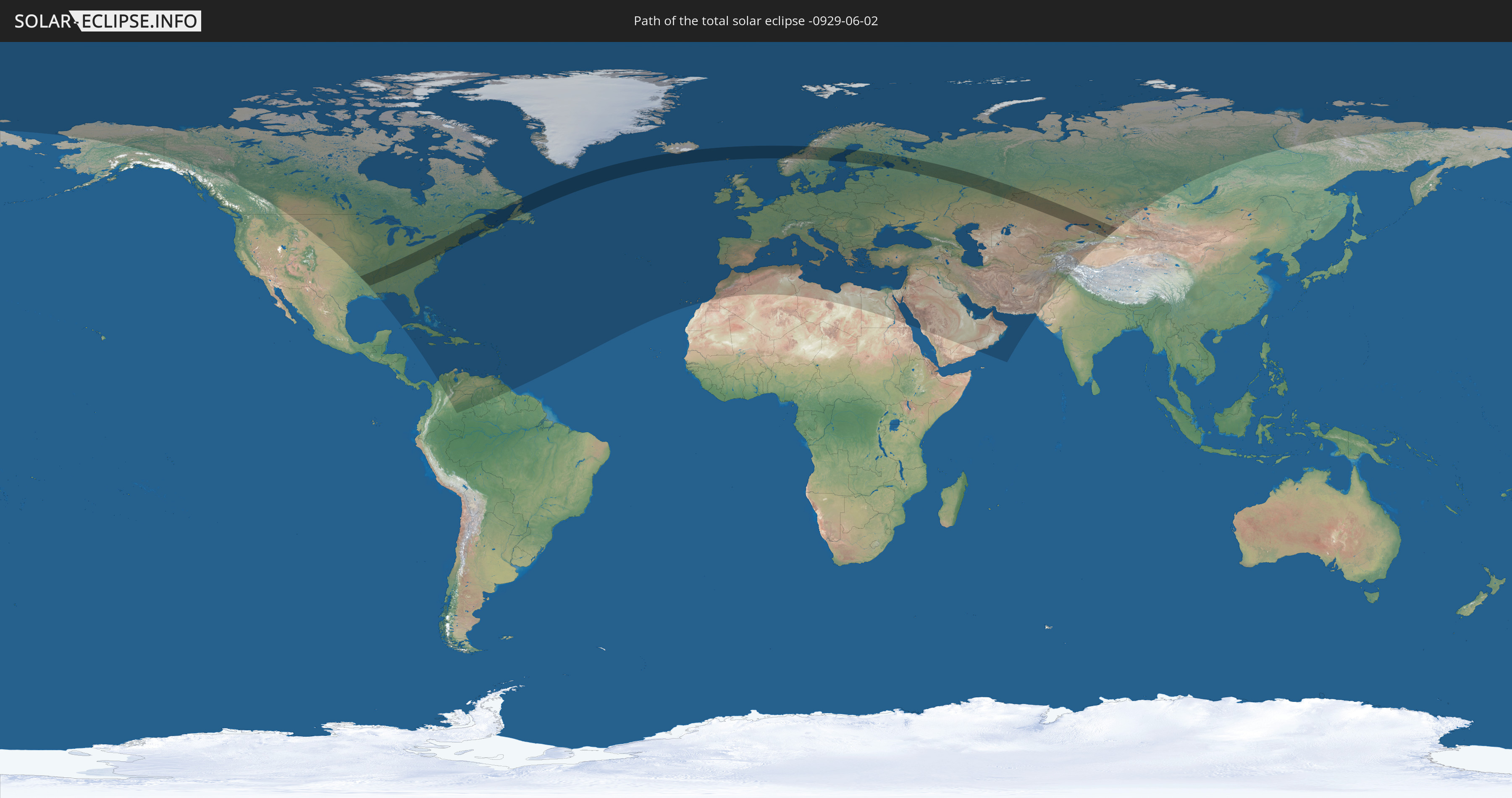
Total solar eclipse of 06/02/-0929
| Day of week: | Wednesday |
| Maximum duration of eclipse: | 04m58s |
| Maximum width of eclipse path: | 332 km |
| Saros cycle: | 32 |
| Coverage: | 100% |
| Magnitude: | 1.076 |
| Gamma: | 0.6682 |
Wo kann man die Sonnenfinsternis vom 06/02/-0929 sehen?
Die Sonnenfinsternis am 06/02/-0929 kann man in 120 Ländern als partielle Sonnenfinsternis beobachten.
Der Finsternispfad verläuft durch 10 Länder. Nur in diesen Ländern ist sie als total Sonnenfinsternis zu sehen.
In den folgenden Ländern ist die Sonnenfinsternis total zu sehen
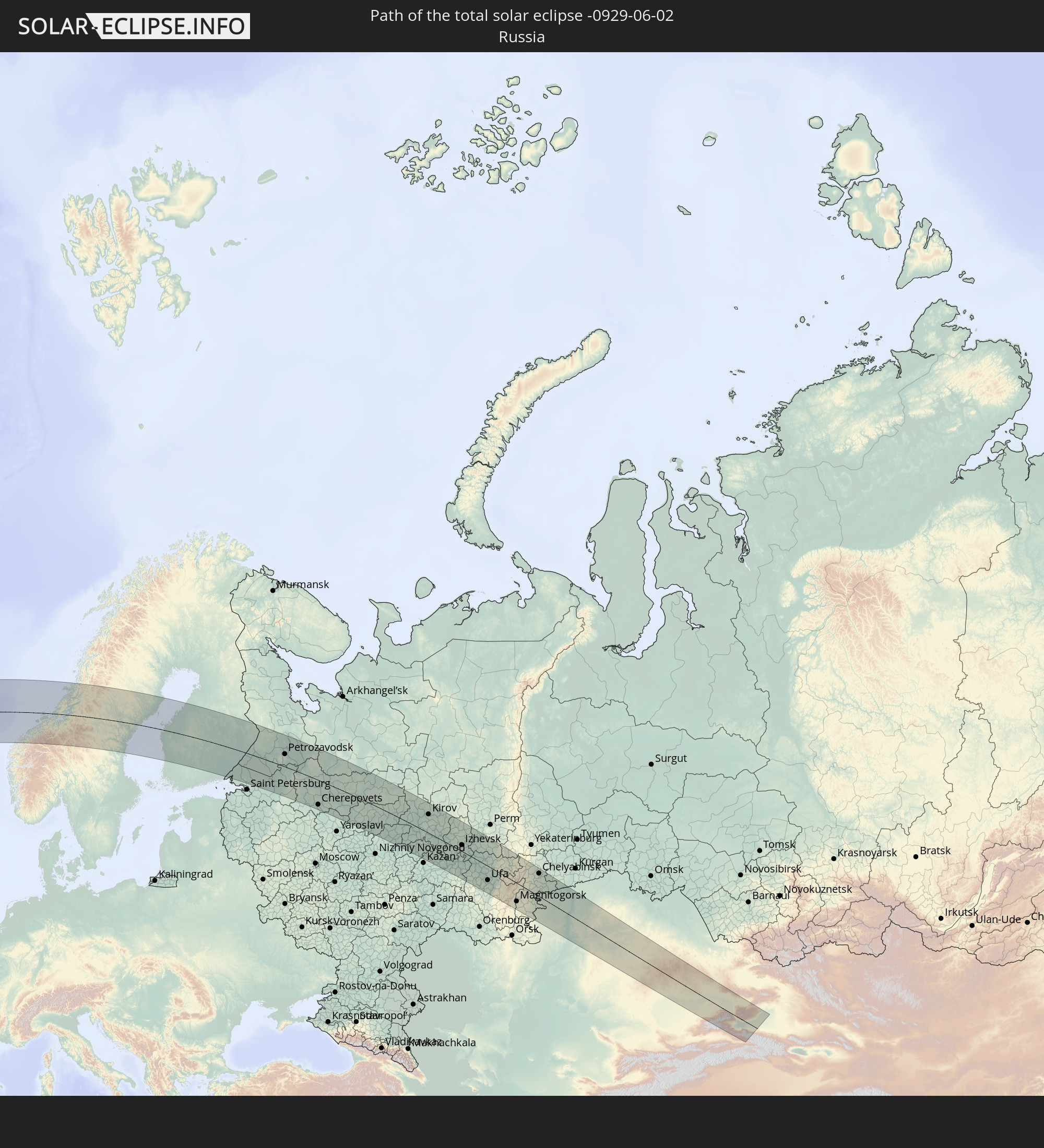 Russia
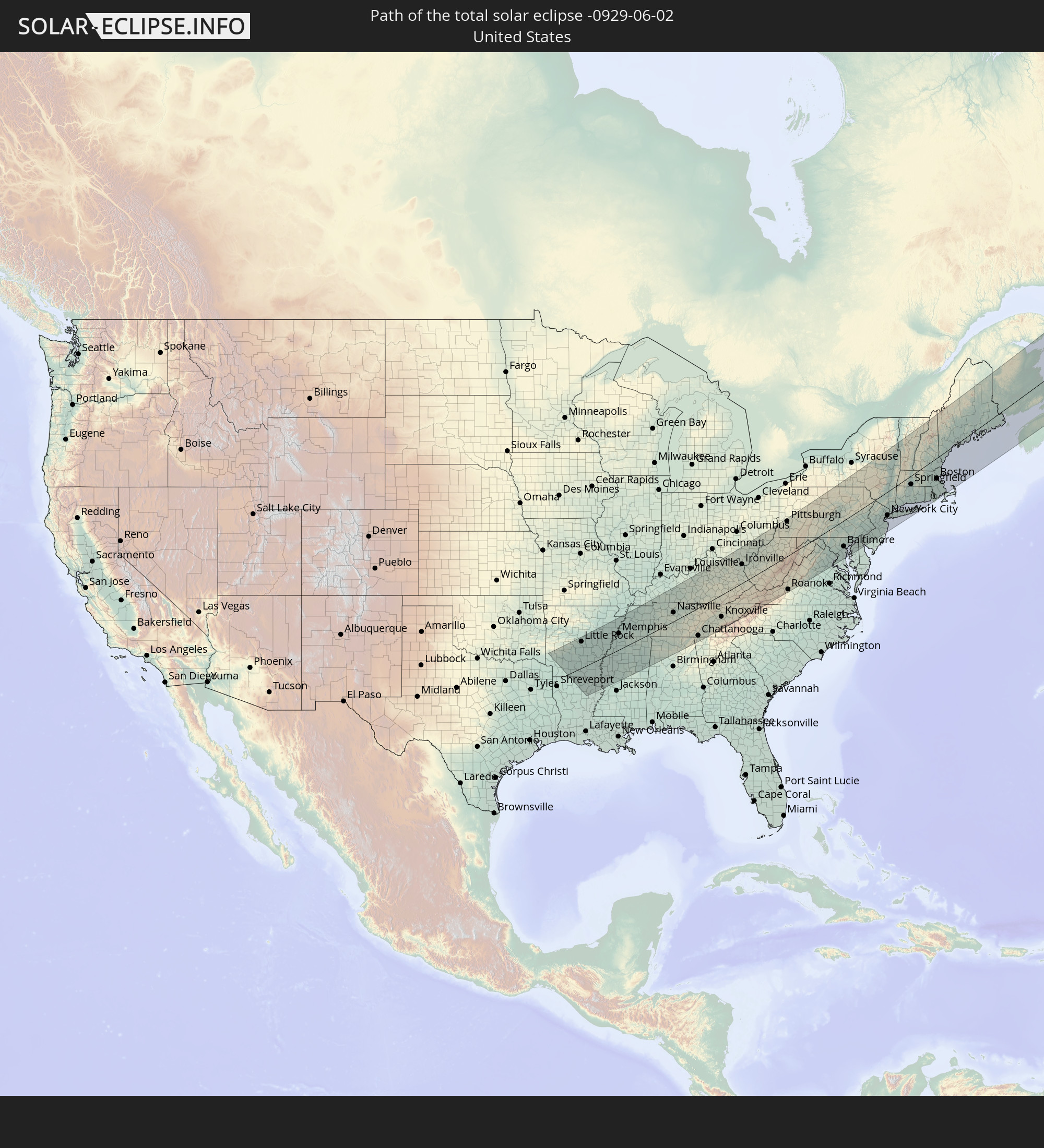 United States
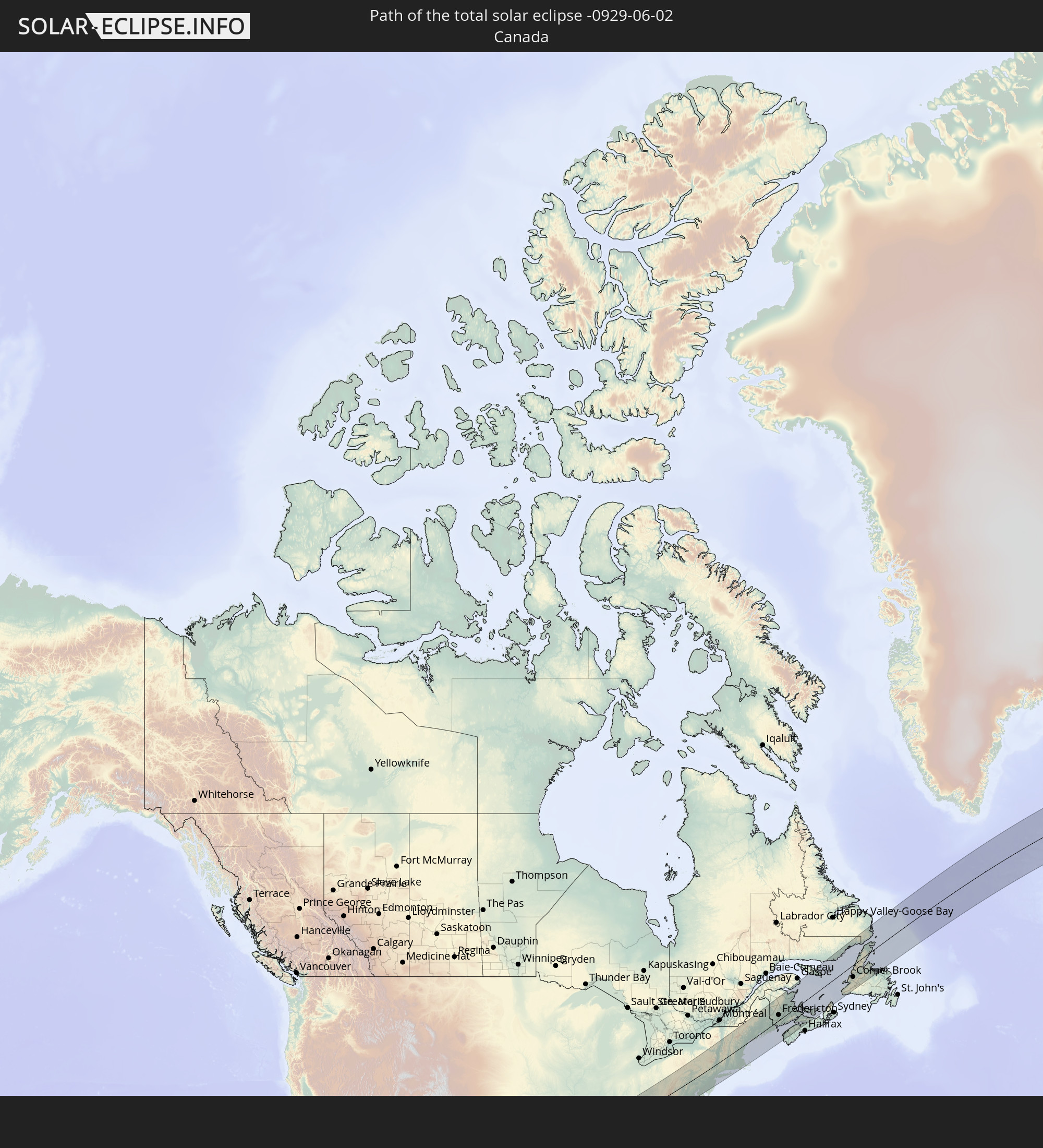 Canada
 Iceland
 Faroe Islands
 Norway
 Sweden
 Finland
 Kazakhstan
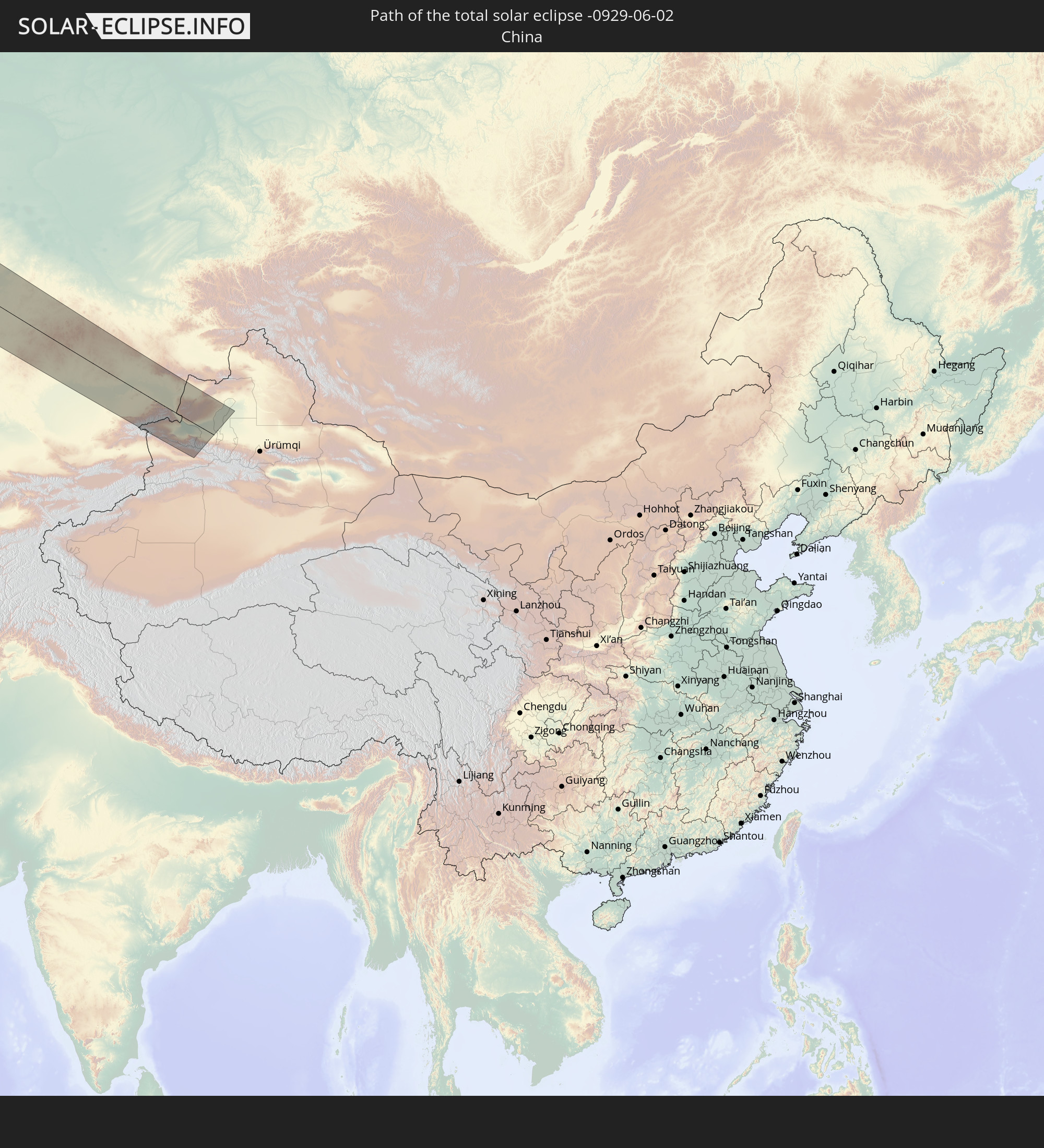 China
China
In den folgenden Ländern ist die Sonnenfinsternis partiell zu sehen
 Russia
 United States
 United States Minor Outlying Islands
 Canada
 Greenland
 Cuba
Cuba
 Colombia
 Cayman Islands
 The Bahamas
 Jamaica
 Haiti
Haiti
 Venezuela
 Turks and Caicos Islands
 Dominican Republic
 Aruba
Aruba
 Puerto Rico
 United States Virgin Islands
 Bermuda
 British Virgin Islands
 Anguilla
 Collectivity of Saint Martin
 Saint Barthélemy
 Saint Kitts and Nevis
 Antigua and Barbuda
 Montserrat
 Trinidad and Tobago
 Guadeloupe
 Grenada
 Dominica
 Saint Vincent and the Grenadines
 Guyana
 Martinique
 Saint Lucia
 Barbados
 Saint Pierre and Miquelon
 Portugal
 Iceland
 Spain
Spain
 Morocco
 Republic of Ireland
 Svalbard and Jan Mayen
 Algeria
 United Kingdom
 Faroe Islands
 Gibraltar
 France
 Isle of Man
 Guernsey
 Jersey
 Andorra
 Belgium
 Netherlands
 Norway
 Luxembourg
 Germany
 Switzerland
 Italy
Italy
 Monaco
 Tunisia
 Denmark
 Libya
Libya
 Liechtenstein
 Austria
 Sweden
 Czechia
 San Marino
 Vatican City
 Slovenia
 Croatia
 Poland
 Malta
Malta
 Bosnia and Herzegovina
 Hungary
 Slovakia
 Montenegro
 Serbia
 Albania
 Åland Islands
 Greece
 Romania
 Republic of Macedonia
 Finland
 Lithuania
 Latvia
 Estonia
 Sudan
Sudan
 Ukraine
 Bulgaria
 Belarus
 Egypt
Egypt
 Turkey
 Moldova
 Cyprus
 State of Palestine
 Israel
 Saudi Arabia
 Jordan
 Lebanon
 Syria
Syria
 Iraq
Iraq
 Georgia
 Yemen
Yemen
 Armenia
 Iran
Iran
 Azerbaijan
 Kazakhstan
 Kuwait
 Bahrain
 Qatar
Qatar
 United Arab Emirates
 Oman
Oman
 Turkmenistan
 Uzbekistan
 Afghanistan
 Pakistan
 Tajikistan
 India
India
 Kyrgyzstan
 China
China
 Mongolia
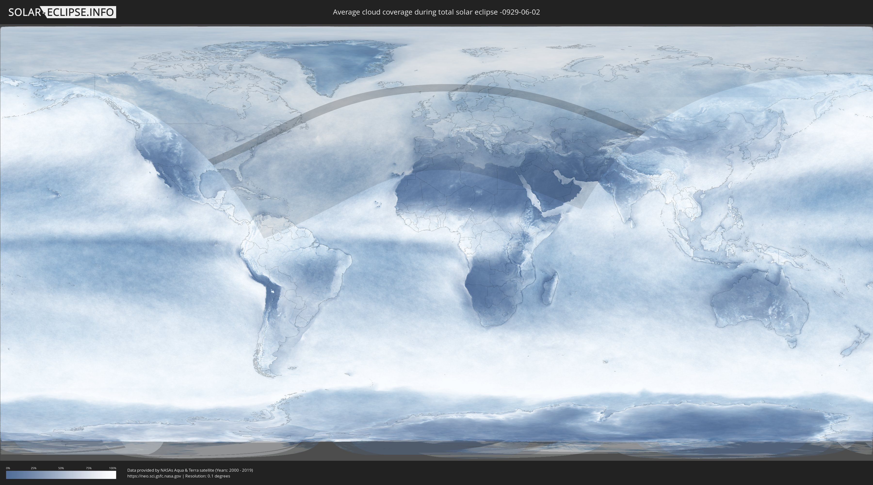
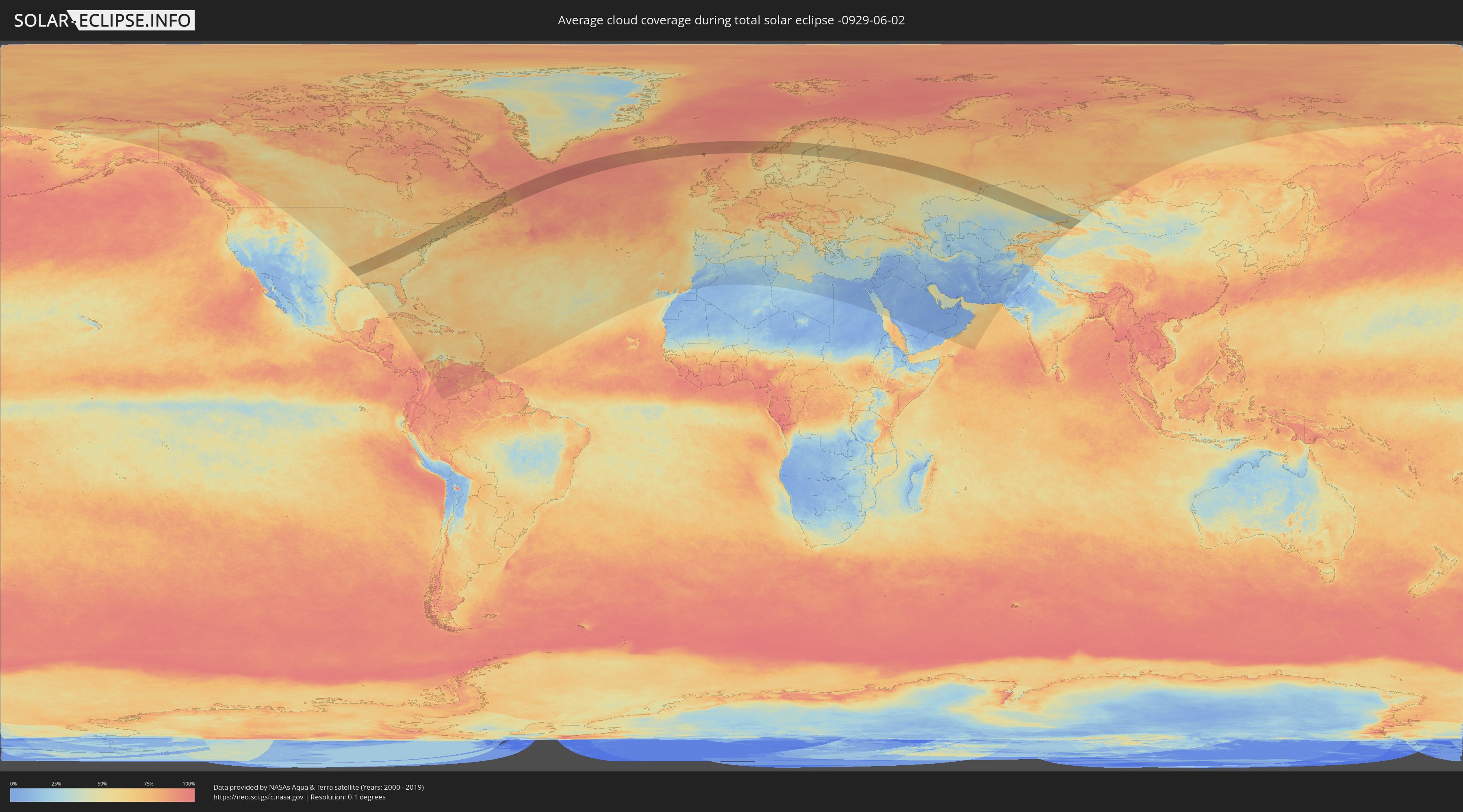
How will be the weather during the total solar eclipse on 06/02/-0929?
Where is the best place to see the total solar eclipse of 06/02/-0929?
The following maps show the average cloud coverage for the day of the total solar eclipse.
With the help of these maps, it is possible to find the place along the eclipse path, which has the best
chance of a cloudless sky.
Nevertheless, you should consider local circumstances and inform about the weather of your chosen
observation site.
The data is provided by NASAs satellites
AQUA and TERRA.
The cloud maps are averaged over a period of 19 years (2000 - 2019).
Detailed country maps
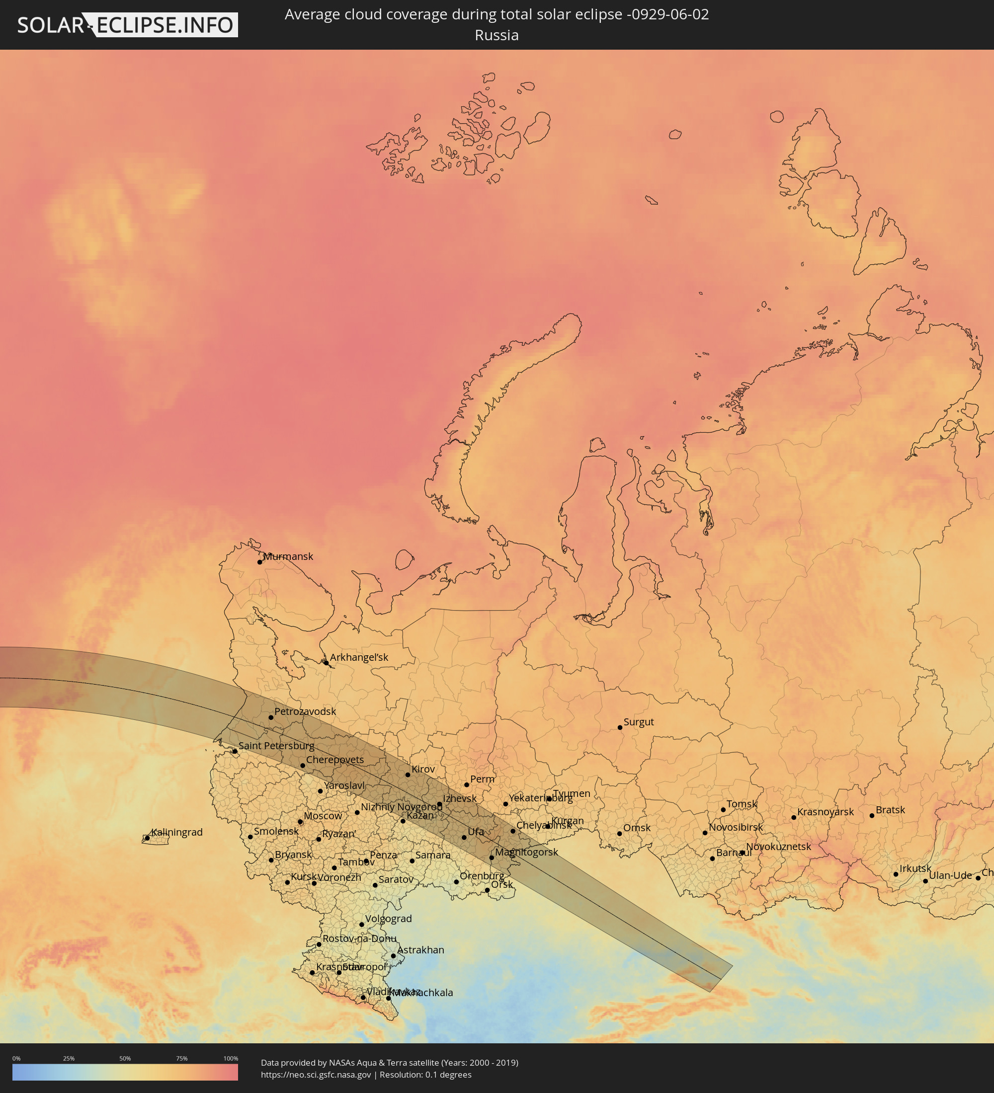 Russia
 United States
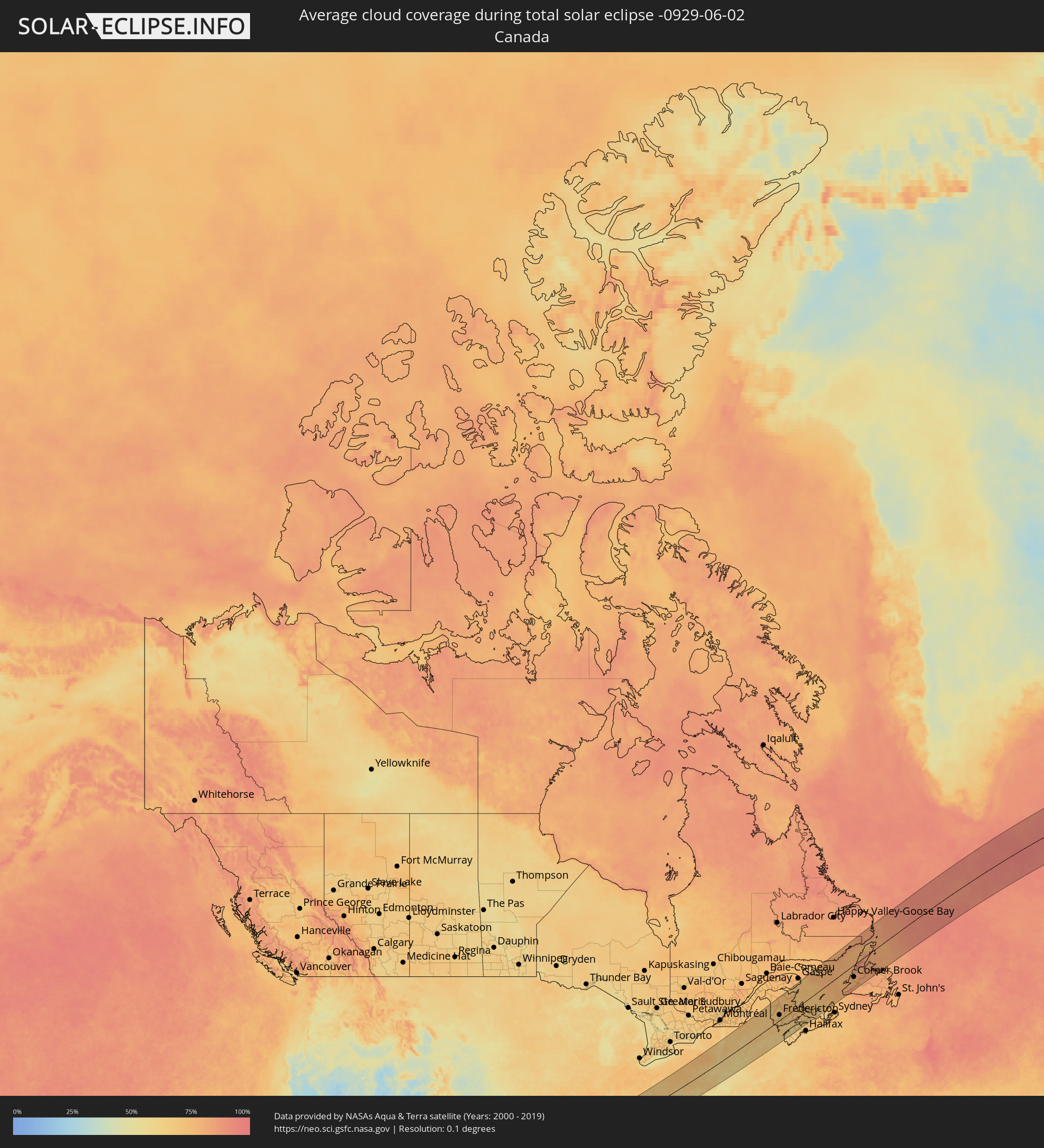 Canada
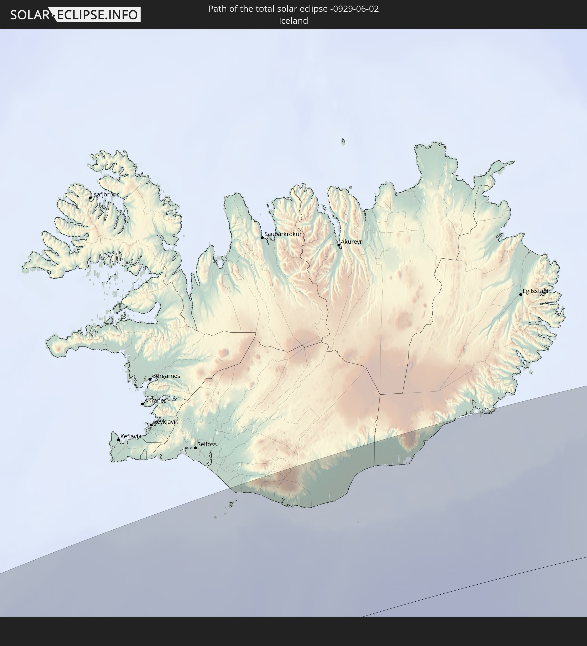
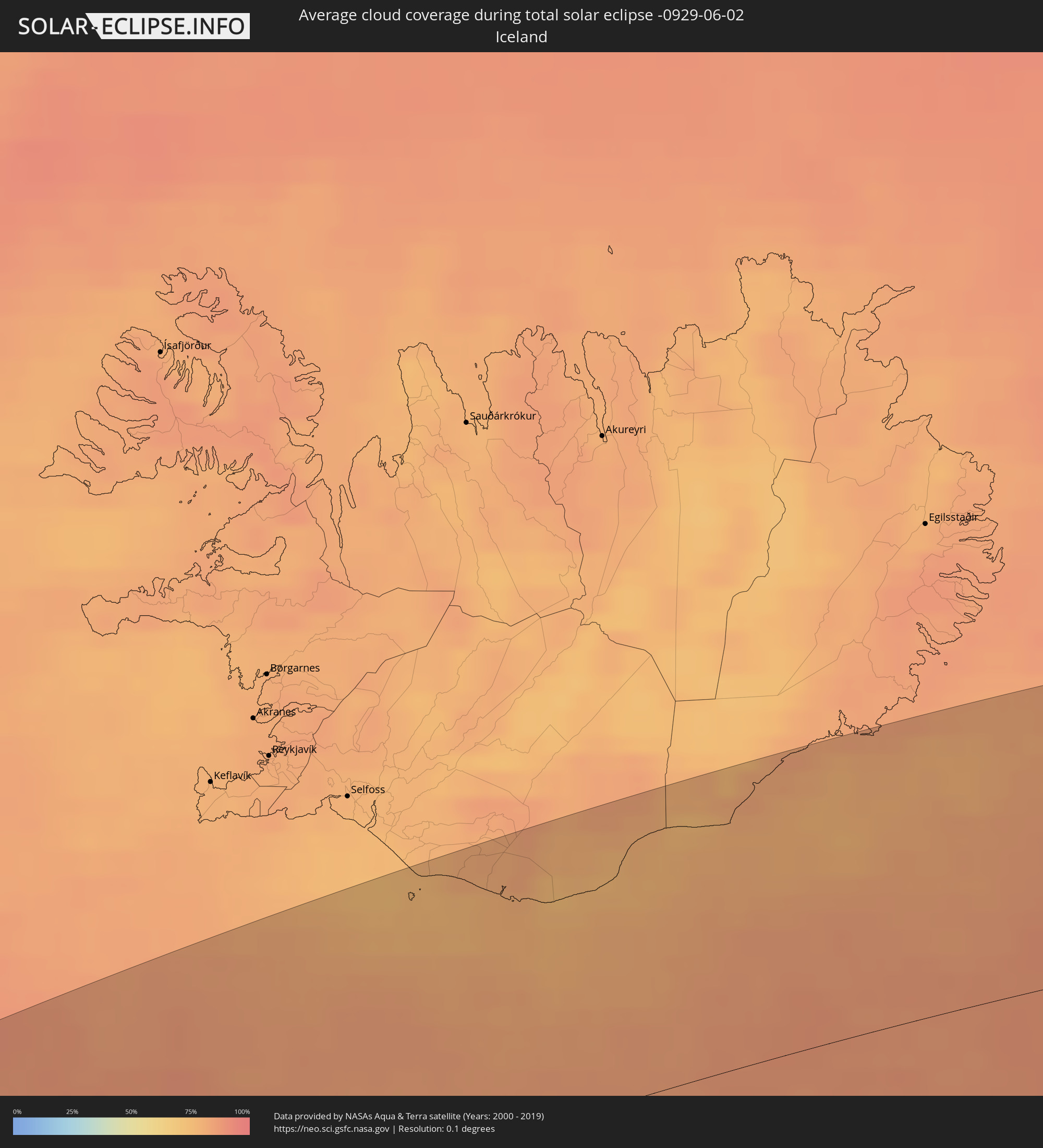 Iceland
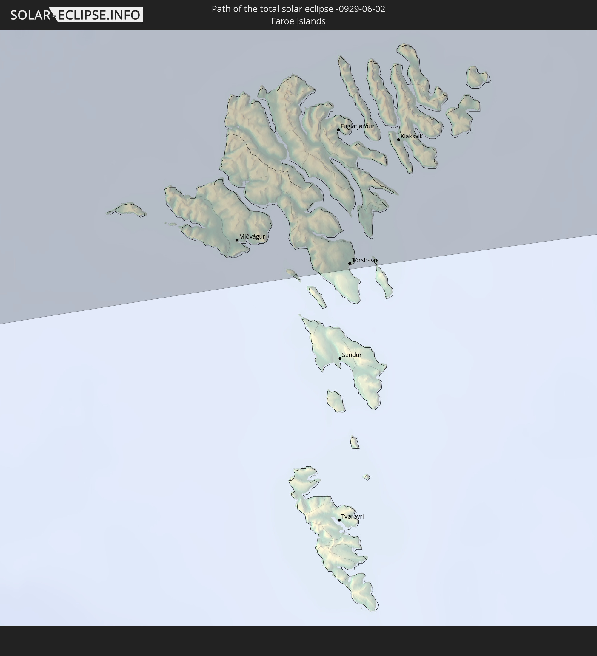
 Faroe Islands
 Norway
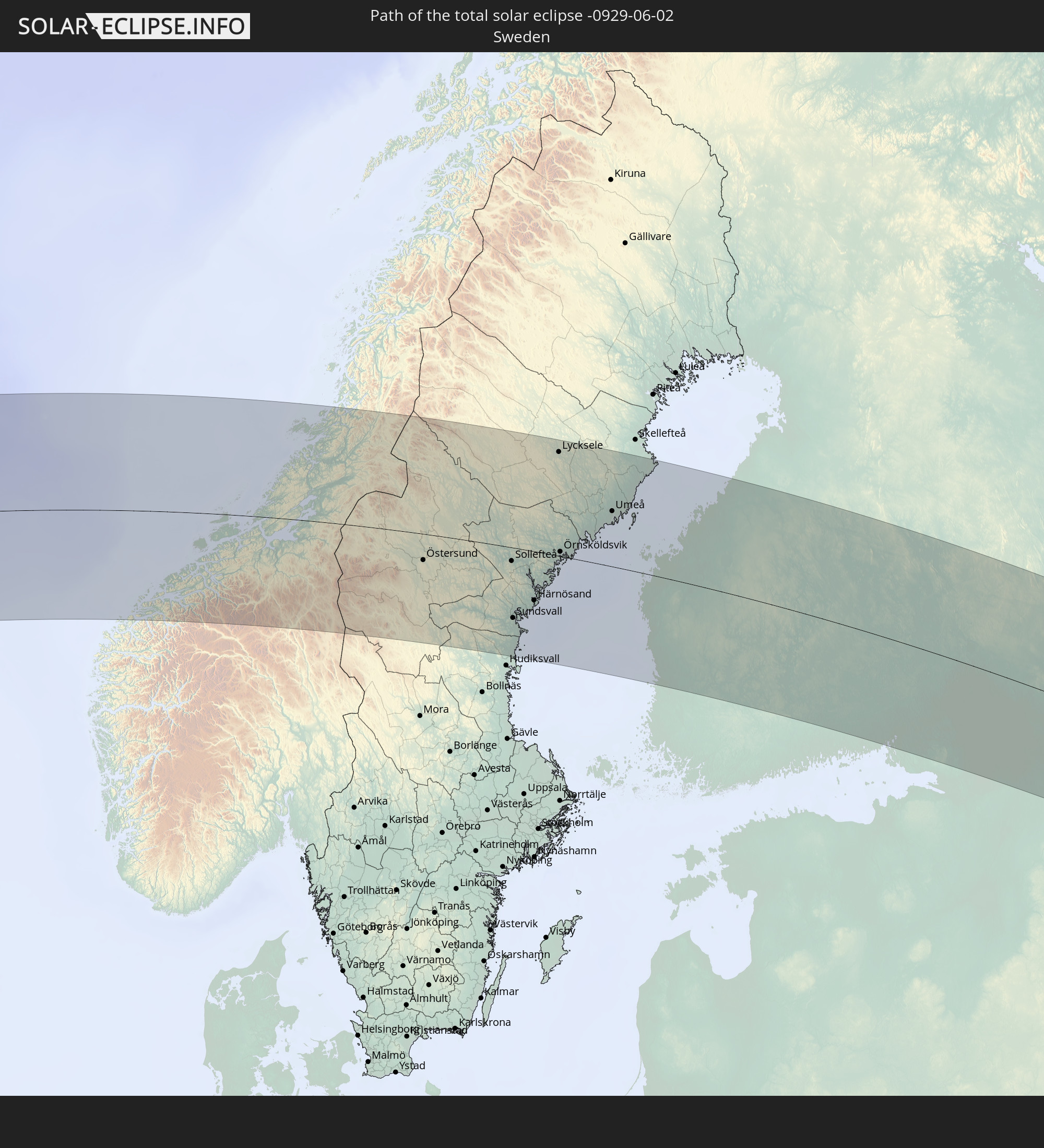
 Sweden
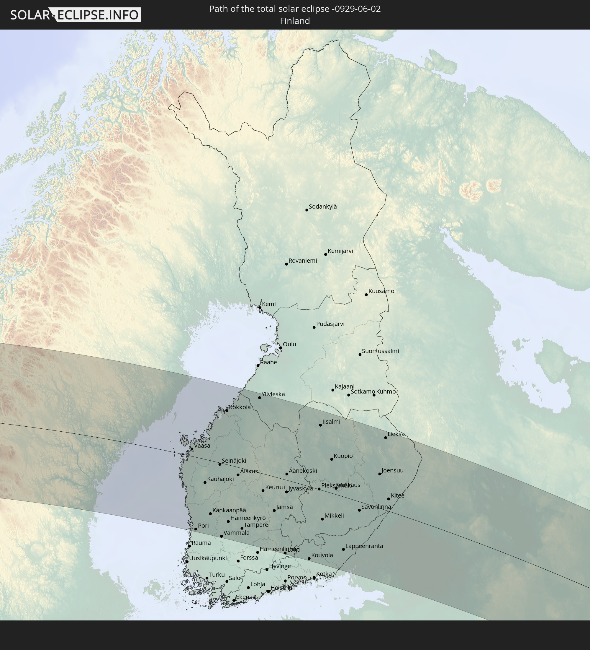
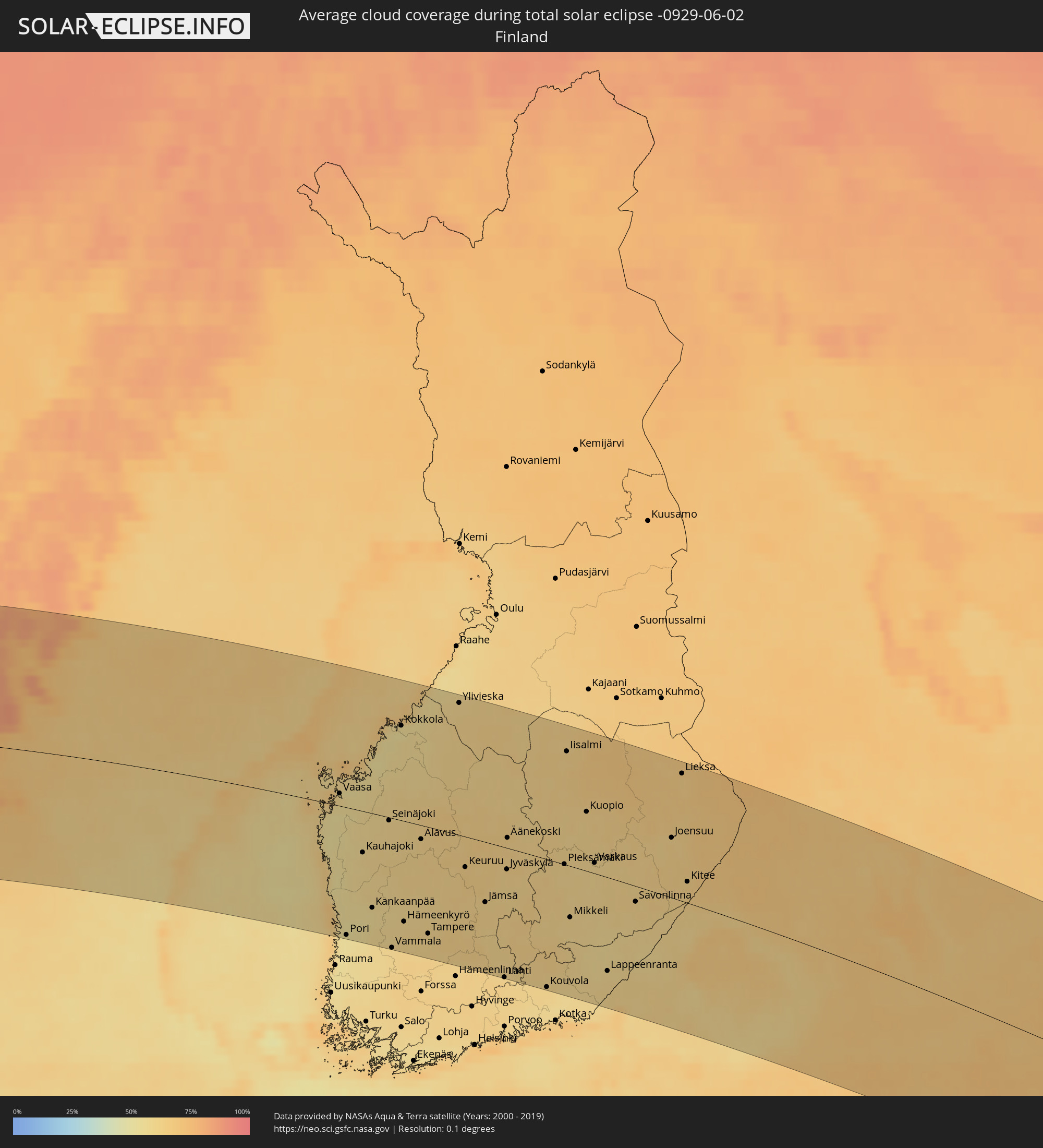 Finland
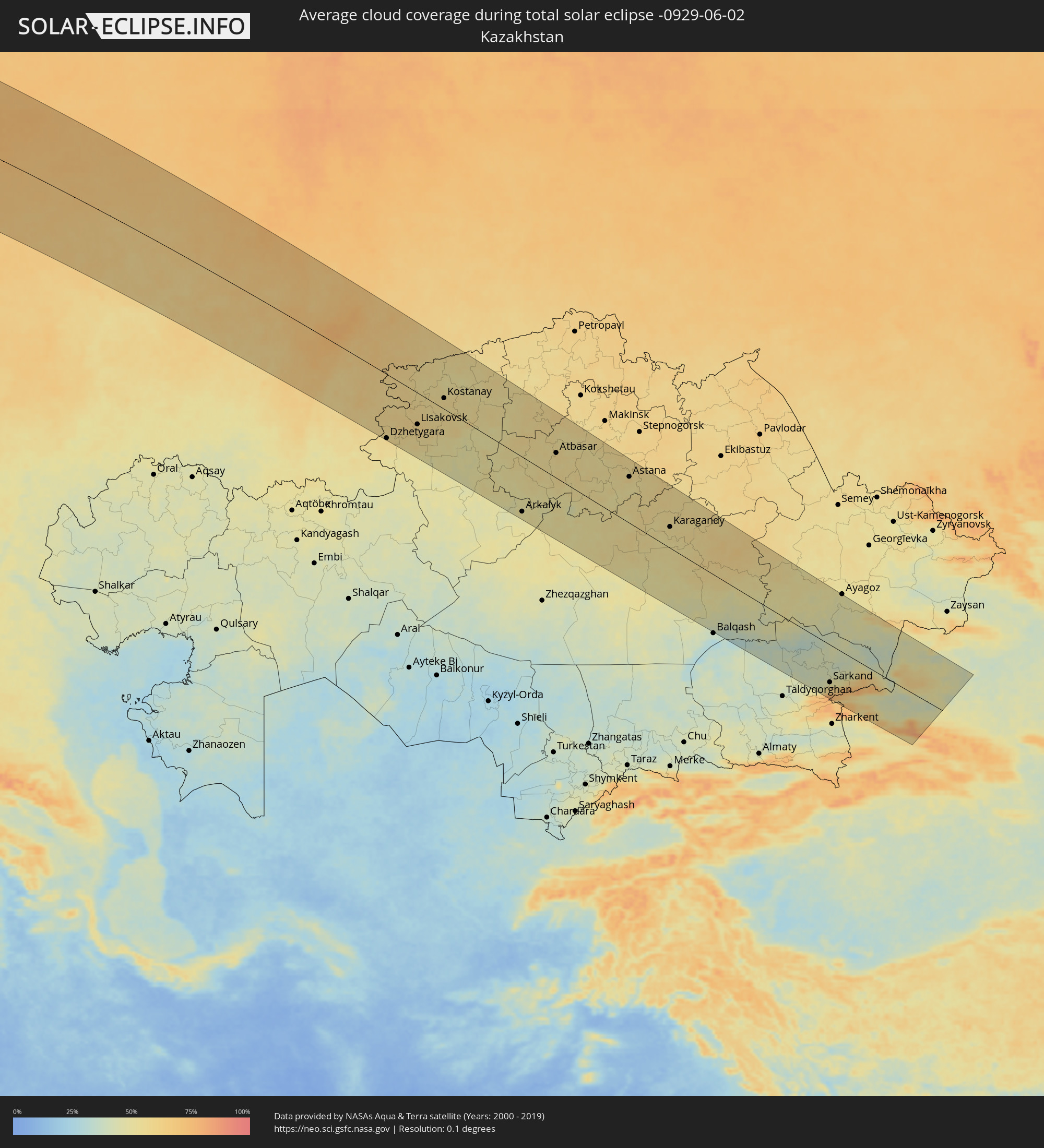 Kazakhstan
 China
China
Cities inside the path of the eclipse
The following table shows all locations with a population of more than 5,000 inside the eclipse path. Cities which have more than 100,000 inhabitants are marked bold. A click at the locations opens a detailed map.
| City | Type | Eclipse duration | Local time of max. eclipse | Distance to central line | Ø Cloud coverage |
|
Little Rock, Arkansas
|
total | - | 05:08:27 UTC-06:00 | 132 km | 63% |
|
Memphis, Tennessee
|
total | - | 05:08:06 UTC-06:00 | 81 km | 70% |
|
Clarksville, Tennessee
|
total | - | 05:08:54 UTC-06:00 | 104 km | 66% |
|
Nashville, Tennessee
|
total | - | 05:08:18 UTC-06:00 | 42 km | 73% |
|
Huntsville, Alabama
|
total | - | 05:06:30 UTC-06:00 | 108 km | 70% |
|
Chattanooga, Tennessee
|
total | - | 06:06:31 UTC-05:00 | 131 km | 68% |
|
Lexington-Fayette, Kentucky
|
total | - | 06:10:06 UTC-05:00 | 126 km | 72% |
|
Knoxville, Tennessee
|
total | - | 06:07:19 UTC-05:00 | 102 km | 63% |
|
Ironville, Kentucky
|
total | - | 06:10:18 UTC-05:00 | 85 km | 63% |
|
Pittsburgh, Pennsylvania
|
total | - | 06:12:38 UTC-05:00 | 152 km | 70% |
|
Washington, D.C., Washington, D.C.
|
total | - | 06:10:15 UTC-05:00 | 130 km | 63% |
|
Baltimore, Maryland
|
total | - | 06:10:47 UTC-05:00 | 113 km | 61% |
|
Philadelphia, Pennsylvania
|
total | - | 06:11:42 UTC-05:00 | 116 km | 65% |
|
Paterson, New Jersey
|
total | - | 06:13:07 UTC-05:00 | 72 km | 65% |
|
Staten Island, New York
|
total | - | 06:12:36 UTC-05:00 | 107 km | 64% |
|
New York City, New York
|
total | - | 06:12:50 UTC-05:00 | 98 km | 66% |
|
The Bronx, New York
|
total | - | 06:13:02 UTC-05:00 | 92 km | 64% |
|
Jamaica, New York
|
total | - | 06:12:48 UTC-05:00 | 110 km | 60% |
|
Bridgeport, Connecticut
|
total | - | 06:13:32 UTC-05:00 | 95 km | 58% |
|
Springfield, Massachusetts
|
total | - | 06:14:59 UTC-05:00 | 39 km | 61% |
|
Worcester, Massachusetts
|
total | - | 06:15:18 UTC-05:00 | 60 km | 58% |
|
Providence, Rhode Island
|
total | - | 06:14:40 UTC-05:00 | 117 km | 59% |
|
Boston, Massachusetts
|
total | - | 06:15:31 UTC-05:00 | 84 km | 62% |
|
Fredericton, New Brunswick
|
total | - | 07:07:35 UTC-04:14 | 41 km | 66% |
|
Oromocto, New Brunswick
|
total | - | 07:07:27 UTC-04:14 | 27 km | 69% |
|
Saint John, New Brunswick
|
total | - | 07:06:39 UTC-04:14 | 49 km | 66% |
|
Bathurst, New Brunswick
|
total | - | 07:10:34 UTC-04:14 | 142 km | 73% |
|
Miramichi, New Brunswick
|
total | - | 07:09:39 UTC-04:14 | 84 km | 72% |
|
Greenwood, Nova Scotia
|
total | - | 07:06:29 UTC-04:14 | 128 km | 61% |
|
Lutes Mountain, New Brunswick
|
total | - | 07:08:22 UTC-04:14 | 26 km | 72% |
|
Moncton, New Brunswick
|
total | - | 07:08:20 UTC-04:14 | 33 km | 72% |
|
Dieppe, New Brunswick
|
total | - | 07:08:21 UTC-04:14 | 39 km | 72% |
|
Chandler, Quebec
|
total | - | 06:26:28 UTC-05:00 | 163 km | 74% |
|
Kentville, Nova Scotia
|
total | - | 07:06:47 UTC-04:14 | 138 km | 63% |
|
Sackville, New Brunswick
|
total | - | 07:08:11 UTC-04:14 | 68 km | 67% |
|
Amherst, Nova Scotia
|
total | - | 07:08:06 UTC-04:14 | 85 km | 67% |
|
Summerside, Prince Edward Island
|
total | - | 07:09:09 UTC-04:14 | 55 km | 70% |
|
Truro, Nova Scotia
|
total | - | 07:07:39 UTC-04:14 | 168 km | 68% |
|
Charlottetown, Prince Edward Island
|
total | - | 07:09:07 UTC-04:14 | 96 km | 72% |
|
Stephenville, Newfoundland and Labrador
|
total | - | 07:58:20 UTC-03:30 | 92 km | 79% |
|
Corner Brook, Newfoundland and Labrador
|
total | - | 07:59:19 UTC-03:30 | 83 km | 77% |
|
Miðvágur, Vágar
|
total | - | 12:06:47 UTC-00:27 | 155 km | 86% |
|
Fuglafjørður, Eysturoy
|
total | - | 12:07:12 UTC-00:27 | 137 km | 88% |
|
Tórshavn, Streymoy
|
total | - | 12:07:13 UTC-00:27 | 163 km | 87% |
|
Klaksvík, Norðoyar
|
total | - | 12:07:26 UTC-00:27 | 140 km | 87% |
|
Ålesund, Møre og Romsdal
|
total | - | 13:47:32 UTC+01:00 | 152 km | 78% |
|
Molde, Møre og Romsdal
|
total | - | 13:48:22 UTC+01:00 | 121 km | 80% |
|
Kristiansund, Møre og Romsdal
|
total | - | 13:48:42 UTC+01:00 | 78 km | 76% |
|
Trondheim, Sør-Trøndelag
|
total | - | 13:50:57 UTC+01:00 | 34 km | 73% |
|
Malvik, Sør-Trøndelag
|
total | - | 13:51:13 UTC+01:00 | 34 km | 73% |
|
Stjørdalshalsen, Nord-Trøndelag
|
total | - | 13:51:25 UTC+01:00 | 27 km | 73% |
|
Levanger, Nord-Trøndelag
|
total | - | 13:51:32 UTC+01:00 | 12 km | 75% |
|
Verdal, Nord-Trøndelag
|
total | - | 13:51:40 UTC+01:00 | 11 km | 73% |
|
Steinkjer, Nord-Trøndelag
|
total | - | 13:51:31 UTC+01:00 | 36 km | 73% |
|
Namsos, Nord-Trøndelag
|
total | - | 13:51:11 UTC+01:00 | 86 km | 75% |
|
Östersund, Jämtland
|
total | - | 13:54:54 UTC+01:00 | 40 km | 64% |
|
Sollefteå, Västernorrland
|
total | - | 13:57:08 UTC+01:00 | 22 km | 60% |
|
Sundsvall, Västernorrland
|
total | - | 13:57:54 UTC+01:00 | 105 km | 60% |
|
Timrå, Västernorrland
|
total | - | 13:57:49 UTC+01:00 | 94 km | 59% |
|
Kramfors, Västernorrland
|
total | - | 13:57:47 UTC+01:00 | 41 km | 58% |
|
Härnösand, Västernorrland
|
total | - | 13:58:12 UTC+01:00 | 73 km | 63% |
|
Lycksele, Västerbotten
|
total | - | 13:56:52 UTC+01:00 | 149 km | 65% |
|
Örnsköldsvik, Västernorrland
|
total | - | 13:58:12 UTC+01:00 | 12 km | 63% |
|
Umeå, Västerbotten
|
total | - | 13:58:51 UTC+01:00 | 80 km | 62% |
|
Holmsund, Västerbotten
|
total | - | 13:59:04 UTC+01:00 | 68 km | 70% |
|
Vaasa, Ostrobothnia
|
total | - | 14:40:30 UTC+01:39 | 15 km | 58% |
|
Pori, Satakunta
|
total | - | 14:42:23 UTC+01:39 | 158 km | 53% |
|
Jakobstad, Ostrobothnia
|
total | - | 14:40:40 UTC+01:39 | 91 km | 54% |
|
Seinäjoki, Southern Ostrobothnia
|
total | - | 14:41:45 UTC+01:39 | 9 km | 60% |
|
Kokkola, Central Ostrobothnia
|
total | - | 14:40:48 UTC+01:39 | 113 km | 53% |
|
Nokia, Pirkanmaa
|
total | - | 14:43:47 UTC+01:39 | 139 km | 61% |
|
Lempäälä, Pirkanmaa
|
total | - | 14:44:09 UTC+01:39 | 152 km | 61% |
|
Tampere, Pirkanmaa
|
total | - | 14:43:58 UTC+01:39 | 132 km | 61% |
|
Valkeakoski, Pirkanmaa
|
total | - | 14:44:26 UTC+01:39 | 155 km | 61% |
|
Kangasala, Pirkanmaa
|
total | - | 14:44:14 UTC+01:39 | 132 km | 62% |
|
Lahti, Päijänne Tavastia
|
total | - | 14:46:01 UTC+01:39 | 162 km | 62% |
|
Jyväskylä, Central Finland
|
total | - | 14:44:33 UTC+01:39 | 27 km | 62% |
|
Heinola, Päijänne Tavastia
|
total | - | 14:46:02 UTC+01:39 | 133 km | 62% |
|
Kouvola, Kymenlaakso
|
total | - | 14:46:57 UTC+01:39 | 159 km | 61% |
|
Iisalmi, Northern Savo
|
total | - | 14:43:57 UTC+01:39 | 135 km | 63% |
|
Mikkeli, Southern Savonia
|
total | - | 14:46:20 UTC+01:39 | 63 km | 61% |
|
Siilinjärvi, Northern Savo
|
total | - | 14:44:52 UTC+01:39 | 92 km | 64% |
|
Kuopio, Northern Savo
|
total | - | 14:45:07 UTC+01:39 | 72 km | 62% |
|
Varkaus, Northern Savo
|
total | - | 14:45:58 UTC+01:39 | 17 km | 60% |
|
Lappeenranta, South Karelia
|
total | - | 14:47:47 UTC+01:39 | 116 km | 59% |
|
Imatra, South Karelia
|
total | - | 14:48:02 UTC+01:39 | 96 km | 58% |
|
Vyborg, Leningradskaya Oblast'
|
total | - | 15:39:06 UTC+02:30 | 145 km | 60% |
|
Savonlinna, Southern Savonia
|
total | - | 14:47:14 UTC+01:39 | 19 km | 61% |
|
Joensuu, North Karelia
|
total | - | 14:46:52 UTC+01:39 | 73 km | 63% |
|
Petrozavodsk, Republic of Karelia
|
total | - | 15:41:16 UTC+02:30 | 67 km | 67% |
|
Cherepovets, Vologda
|
total | - | 15:47:04 UTC+02:30 | 136 km | 66% |
|
Vologda, Vologda
|
total | - | 15:47:59 UTC+02:30 | 82 km | 69% |
|
Yoshkar-Ola, Mariy-El
|
total | - | 15:55:22 UTC+02:30 | 139 km | 64% |
|
Kirov, Kirov
|
total | - | 15:52:58 UTC+02:30 | 104 km | 68% |
|
Kirovo-Chepetsk, Kirov
|
total | - | 15:53:09 UTC+02:30 | 110 km | 68% |
|
Nizhnekamsk, Tatarstan
|
total | - | 15:58:07 UTC+02:30 | 125 km | 59% |
|
Yelabuga, Tatarstan
|
total | - | 15:58:00 UTC+02:30 | 105 km | 61% |
|
Naberezhnyye Chelny, Tatarstan
|
total | - | 15:58:08 UTC+02:30 | 98 km | 62% |
|
Glazov, Udmurtiya
|
total | - | 16:44:34 UTC+03:20 | 144 km | 67% |
|
Izhevsk, Udmurtiya
|
total | - | 16:46:41 UTC+03:20 | 36 km | 67% |
|
Sarapul, Udmurtiya
|
total | - | 16:47:23 UTC+03:20 | 21 km | 63% |
|
Votkinsk, Udmurtiya
|
total | - | 16:46:34 UTC+03:20 | 79 km | 66% |
|
Chaykovskiy, Perm
|
total | - | 17:29:14 UTC+04:02 | 56 km | 68% |
|
Neftekamsk, Bashkortostan
|
total | - | 17:30:18 UTC+04:02 | 6 km | 64% |
|
Ufa, Bashkortostan
|
total | - | 17:32:40 UTC+04:02 | 84 km | 63% |
|
Beloretsk, Bashkortostan
|
total | - | 17:34:13 UTC+04:02 | 80 km | 67% |
|
Magnitogorsk, Chelyabinsk
|
total | - | 17:35:05 UTC+04:02 | 111 km | 59% |
|
Zlatoust, Chelyabinsk
|
total | - | 17:32:34 UTC+04:02 | 77 km | 73% |
|
Miass, Chelyabinsk
|
total | - | 17:32:49 UTC+04:02 | 80 km | 69% |
|
Dzhetygara, Qostanay
|
total | - | 17:56:23 UTC+04:21 | 156 km | 58% |
|
Chelyabinsk, Chelyabinsk
|
total | - | 17:32:46 UTC+04:02 | 135 km | 69% |
|
Troitsk, Chelyabinsk
|
total | - | 17:34:20 UTC+04:02 | 44 km | 62% |
|
Komsomolets, Qostanay
|
total | - | 17:54:11 UTC+04:21 | 25 km | 58% |
|
Lisakovsk, Qostanay
|
total | - | 17:55:56 UTC+04:21 | 77 km | 57% |
|
Kachar, Qostanay
|
total | - | 17:54:46 UTC+04:21 | 24 km | 56% |
|
Rudnyy, Qostanay
|
total | - | 17:55:21 UTC+04:21 | 23 km | 55% |
|
Kostanay, Qostanay
|
total | - | 17:55:01 UTC+04:21 | 27 km | 57% |
|
Borovskoy, Qostanay
|
total | - | 17:54:11 UTC+04:21 | 101 km | 50% |
|
Derzhavīnsk, Aqmola
|
total | - | 17:57:57 UTC+04:21 | 80 km | 50% |
|
Esil, Aqmola
|
total | - | 17:56:46 UTC+04:21 | 12 km | 55% |
|
Arkalyk, Qostanay
|
total | - | 17:59:04 UTC+04:21 | 138 km | 49% |
|
Atbasar, Aqmola
|
total | - | 17:56:51 UTC+04:21 | 63 km | 58% |
|
Astana, Astana Qalasy
|
total | - | 17:57:21 UTC+04:21 | 117 km | 59% |
|
Atasū, Qaraghandy
|
total | - | 18:00:34 UTC+04:21 | 112 km | 49% |
|
Aktau, Qaraghandy
|
total | - | 18:01:11 UTC+04:21 | 129 km | 49% |
|
Sorang, Qaraghandy
|
total | - | 17:58:57 UTC+04:21 | 38 km | 53% |
|
Aqadyr, Qaraghandy
|
total | - | 18:00:53 UTC+04:21 | 106 km | 49% |
|
Abay, Qaraghandy
|
total | - | 17:59:09 UTC+04:21 | 25 km | 51% |
|
Aqtas, Qaraghandy
|
total | - | 17:58:57 UTC+04:21 | 42 km | 55% |
|
Temirtau, Qaraghandy
|
total | - | 17:58:35 UTC+04:21 | 68 km | 57% |
|
Aqtaū, Qaraghandy
|
total | - | 17:58:20 UTC+04:21 | 89 km | 55% |
|
Karagandy, Qaraghandy
|
total | - | 17:58:50 UTC+04:21 | 55 km | 54% |
|
Sarkand, Almaty Oblysy
|
total | - | 18:02:22 UTC+04:21 | 106 km | 54% |
|
Urzhar, East Kazakhstan
|
total | - | 17:59:53 UTC+04:21 | 124 km | 45% |
|
Baijiantan, Xinjiang Uyghur Autonomous Region
|
total | - | 21:38:12 UTC+08:00 | 126 km | 45% |