Total solar eclipse of 04/05/-1195
| Day of week: | Sunday |
| Maximum duration of eclipse: | 04m30s |
| Maximum width of eclipse path: | 237 km |
| Saros cycle: | 39 |
| Coverage: | 100% |
| Magnitude: | 1.0595 |
| Gamma: | 0.5854 |
Wo kann man die Sonnenfinsternis vom 04/05/-1195 sehen?
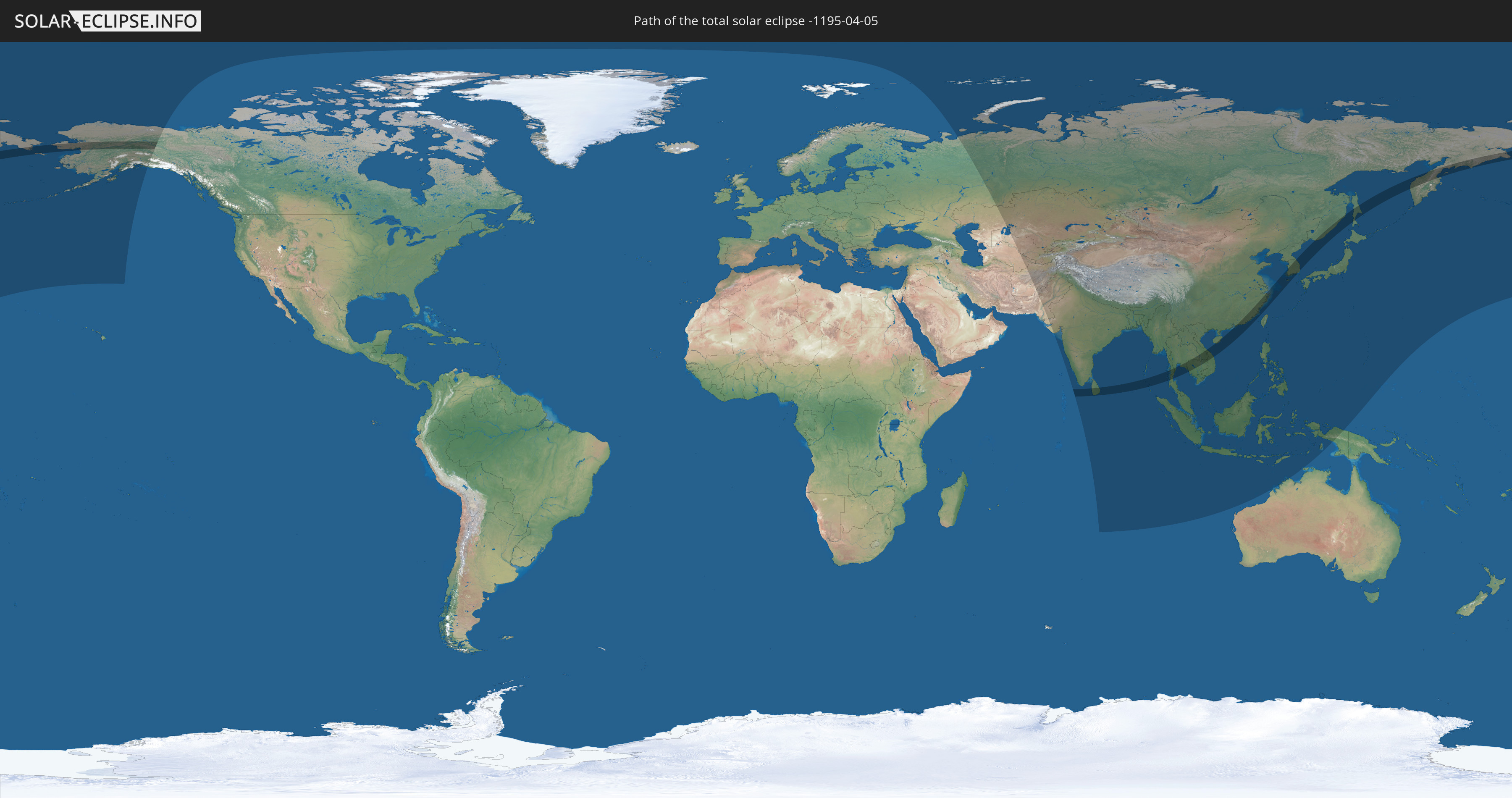
Die Sonnenfinsternis am 04/05/-1195 kann man in 41 Ländern als partielle Sonnenfinsternis beobachten.
Der Finsternispfad verläuft durch 13 Länder. Nur in diesen Ländern ist sie als total Sonnenfinsternis zu sehen.
In den folgenden Ländern ist die Sonnenfinsternis total zu sehen
 Russia
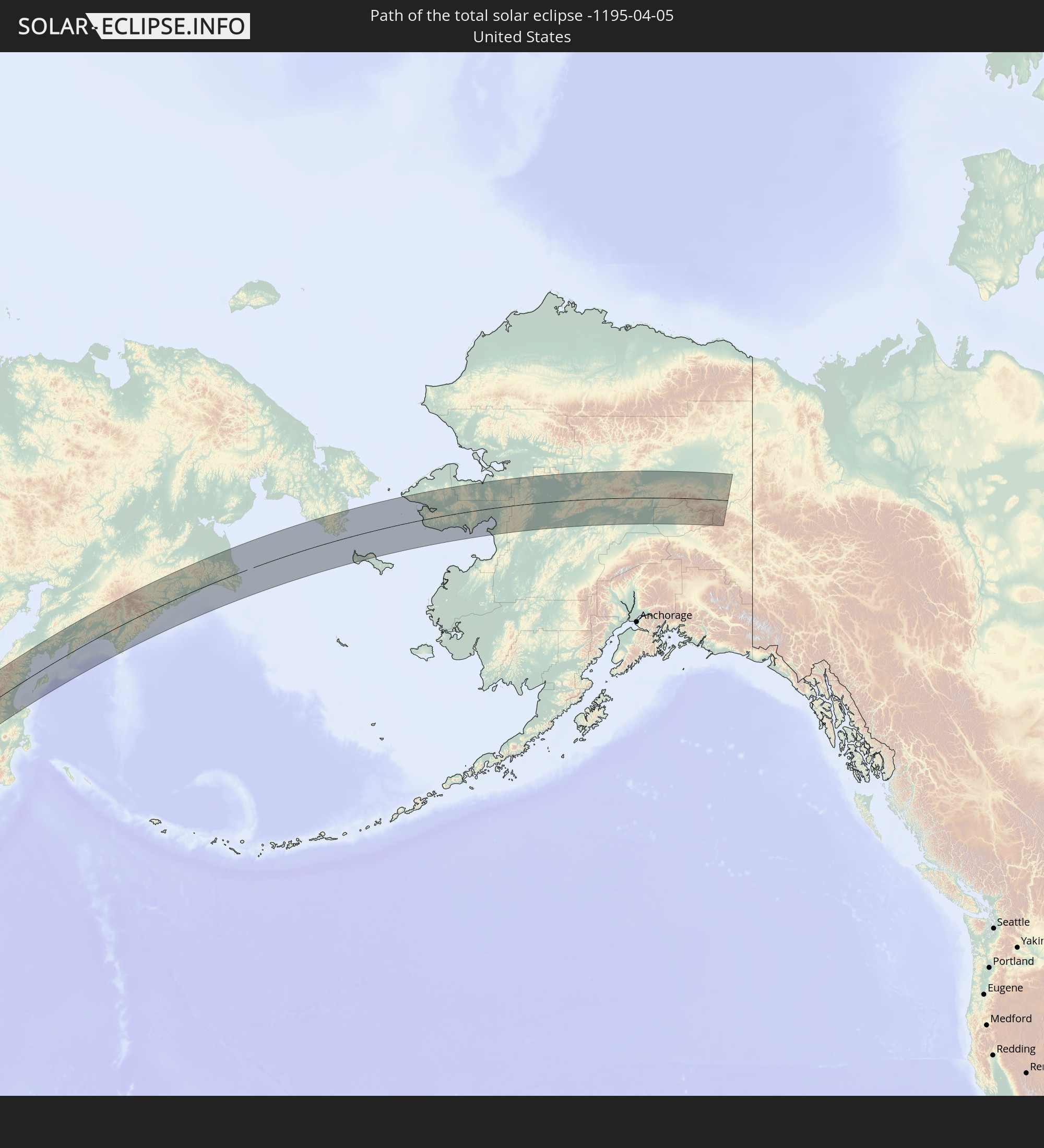 United States
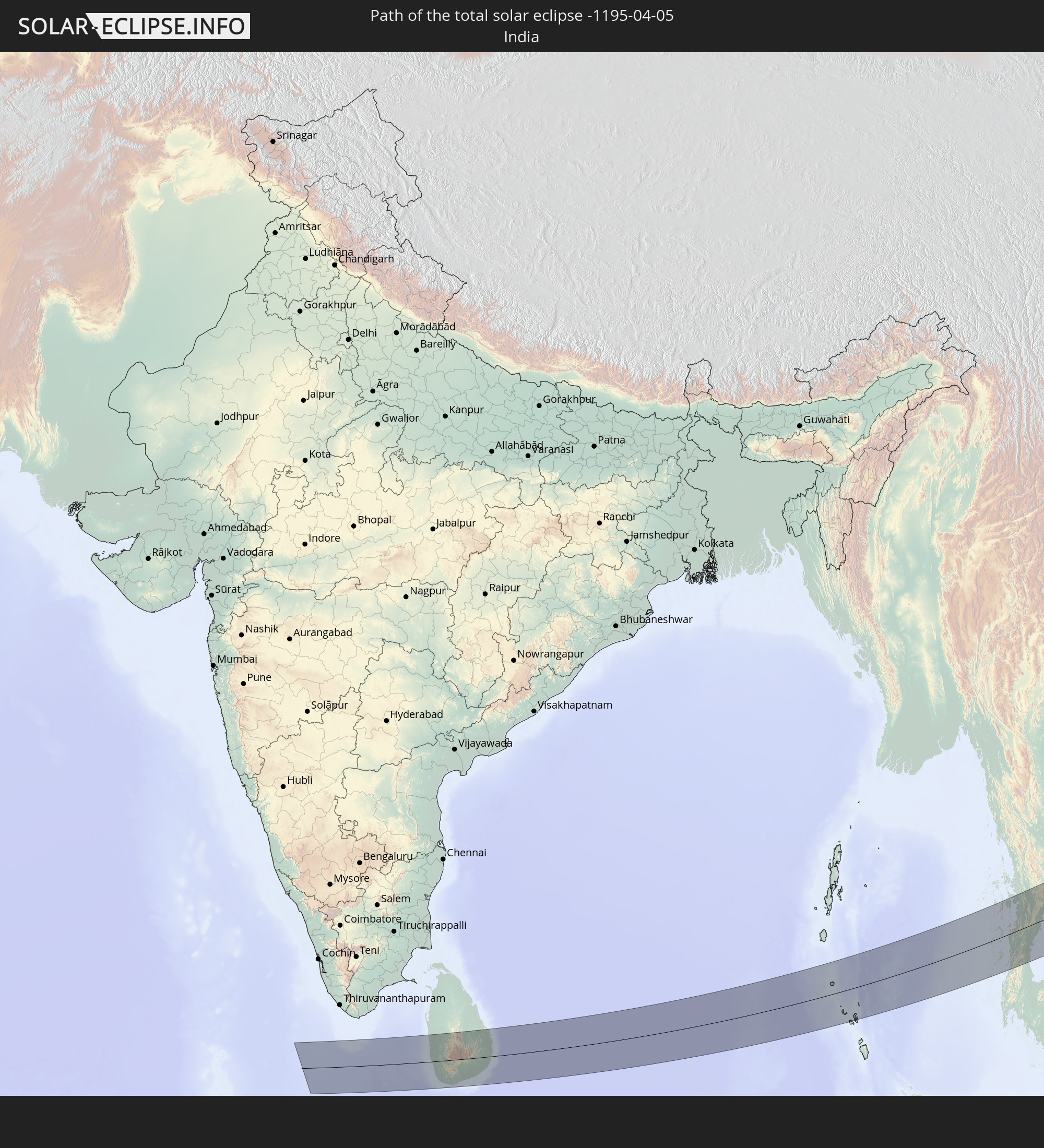 India
India
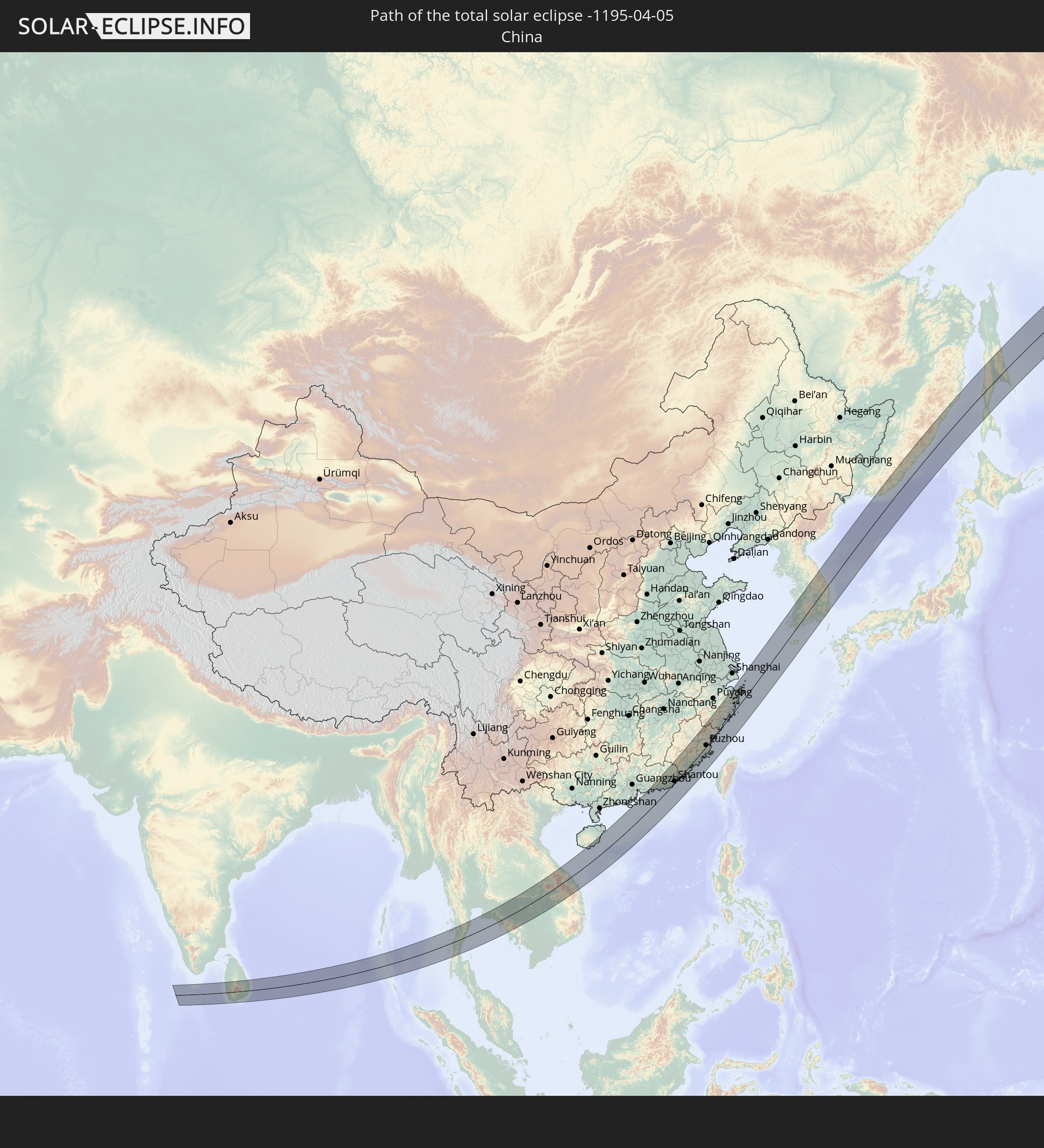 China
China
 Sri Lanka
 Myanmar
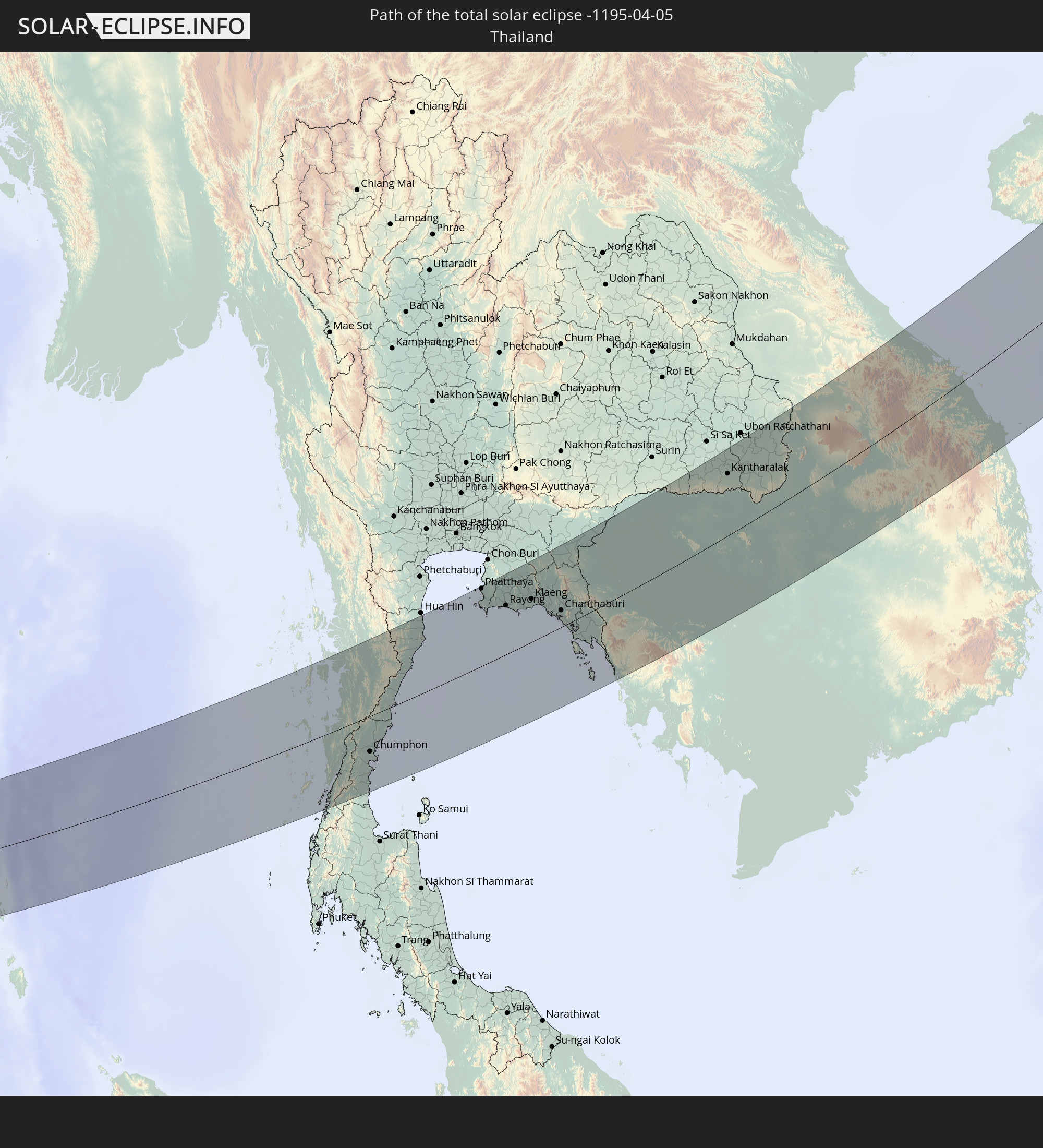 Thailand
 Laos
Laos
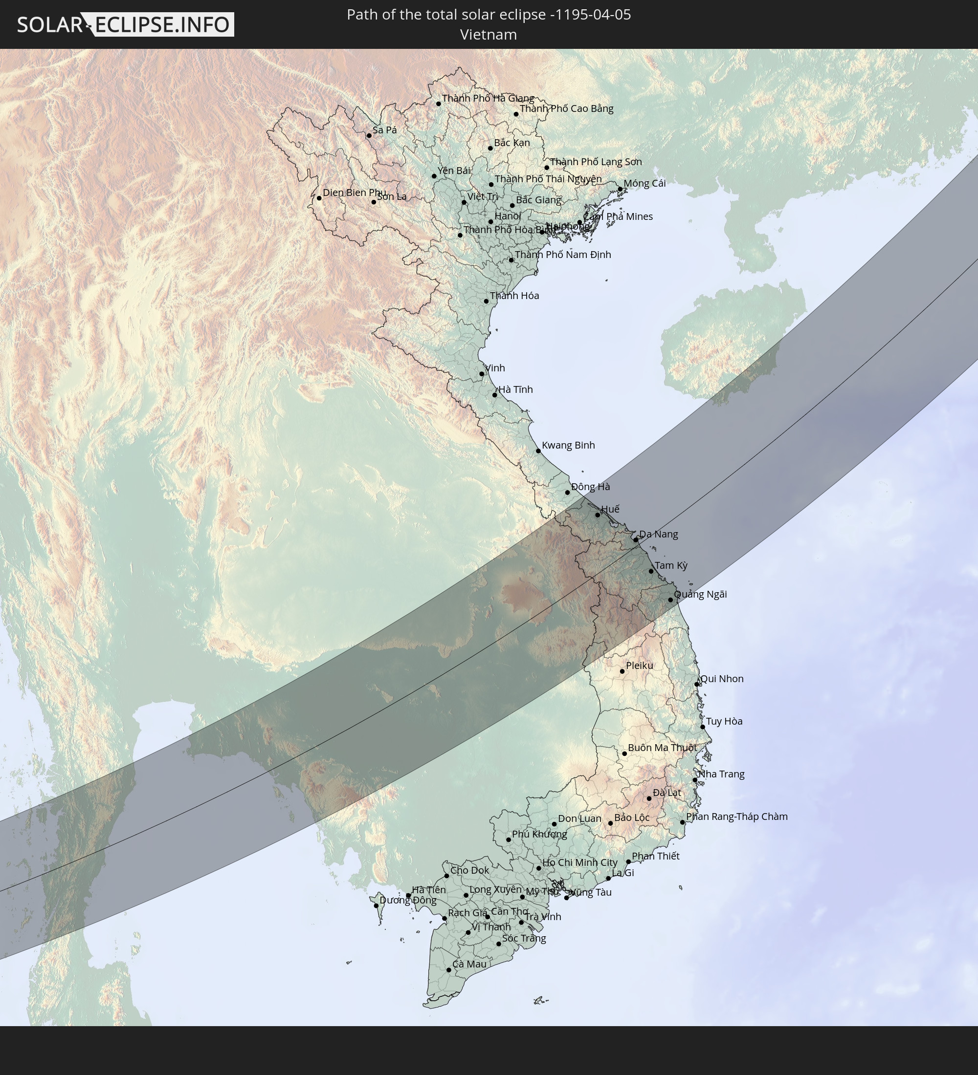 Vietnam
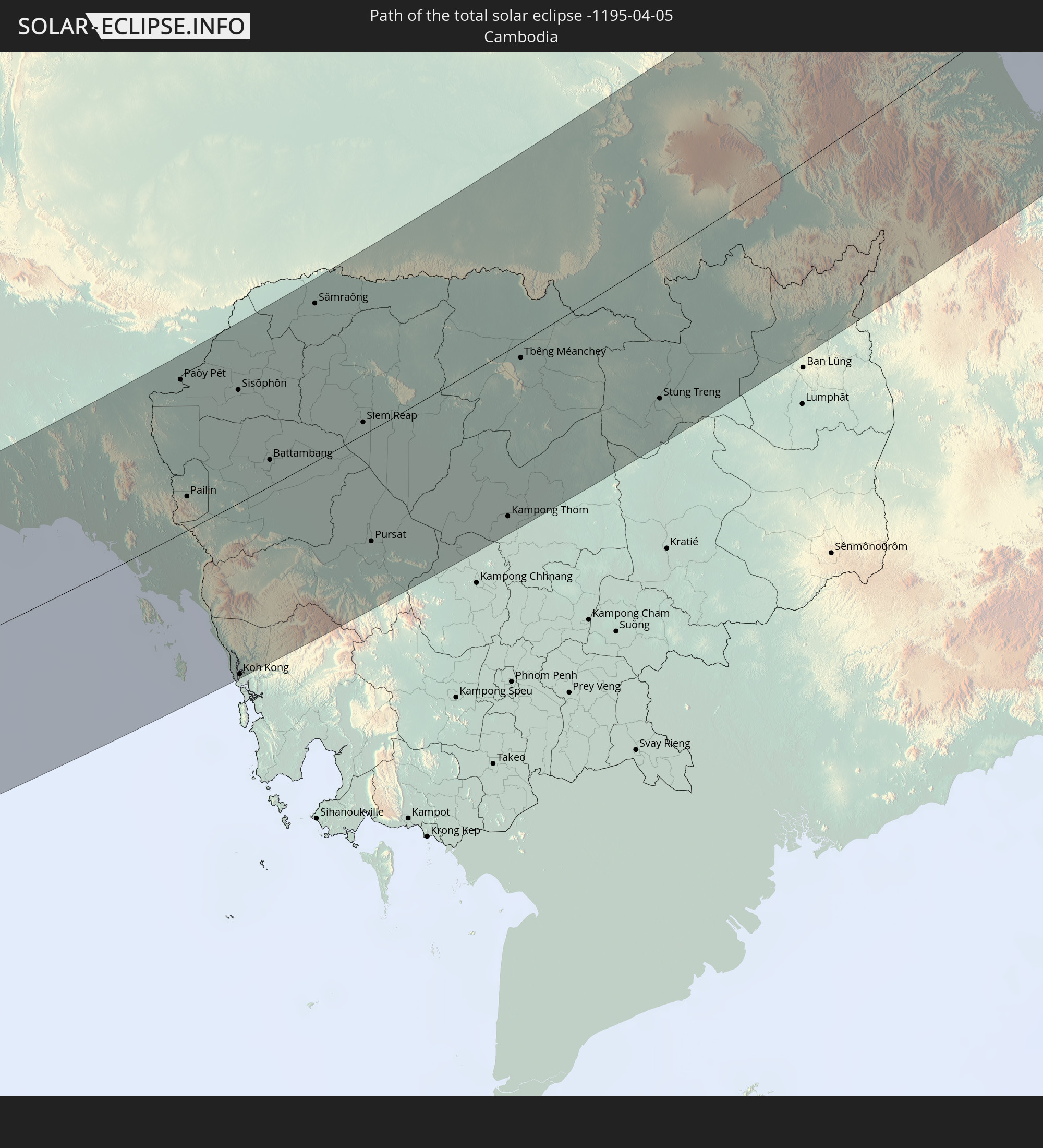 Cambodia
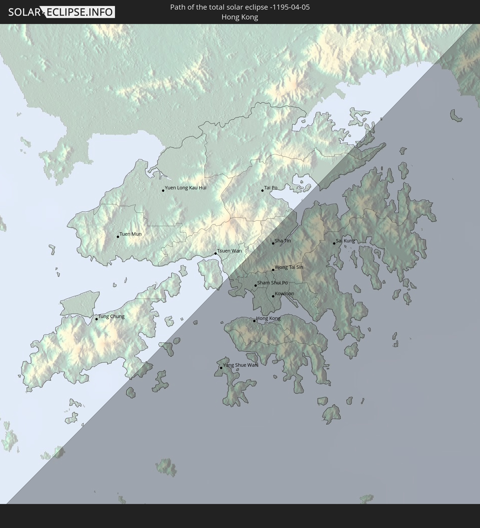 Hong Kong
 Taiwan
 South Korea
In den folgenden Ländern ist die Sonnenfinsternis partiell zu sehen
 Russia
 United States
 Canada
 Kazakhstan
 Turkmenistan
 Uzbekistan
 Afghanistan
 Pakistan
 Tajikistan
 India
India
 Kyrgyzstan
 China
China
 Sri Lanka
 Nepal
Nepal
 Mongolia
 Bangladesh
 Bhutan
 Myanmar
 Indonesia
 Cocos Islands
 Thailand
 Malaysia
 Laos
Laos
 Vietnam
 Cambodia
 Singapore
 Christmas Island
 Australia
 Macau
Macau
 Hong Kong
 Brunei
 Taiwan
 Philippines
 Japan
Japan
 East Timor
 North Korea
 South Korea
 Palau
Palau
 Federated States of Micronesia
 Guam
Guam
 Northern Mariana Islands
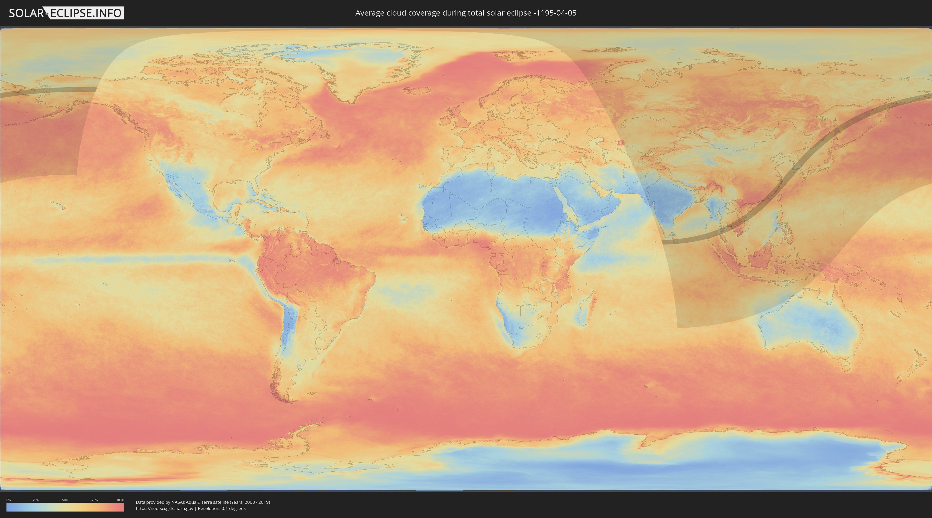
How will be the weather during the total solar eclipse on 04/05/-1195?
Where is the best place to see the total solar eclipse of 04/05/-1195?
The following maps show the average cloud coverage for the day of the total solar eclipse.
With the help of these maps, it is possible to find the place along the eclipse path, which has the best
chance of a cloudless sky.
Nevertheless, you should consider local circumstances and inform about the weather of your chosen
observation site.
The data is provided by NASAs satellites
AQUA and TERRA.
The cloud maps are averaged over a period of 19 years (2000 - 2019).

Detailed country maps
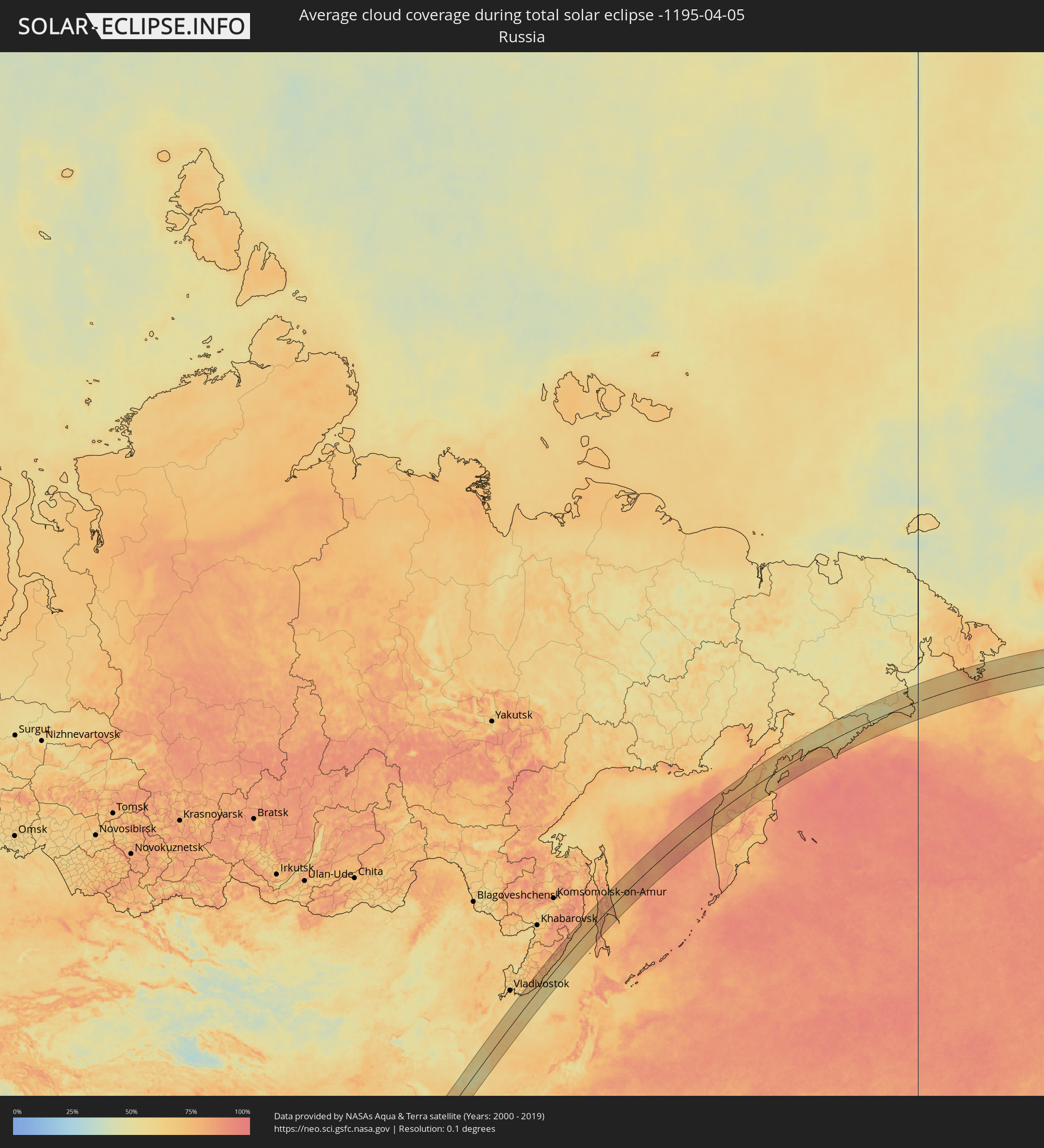 Russia
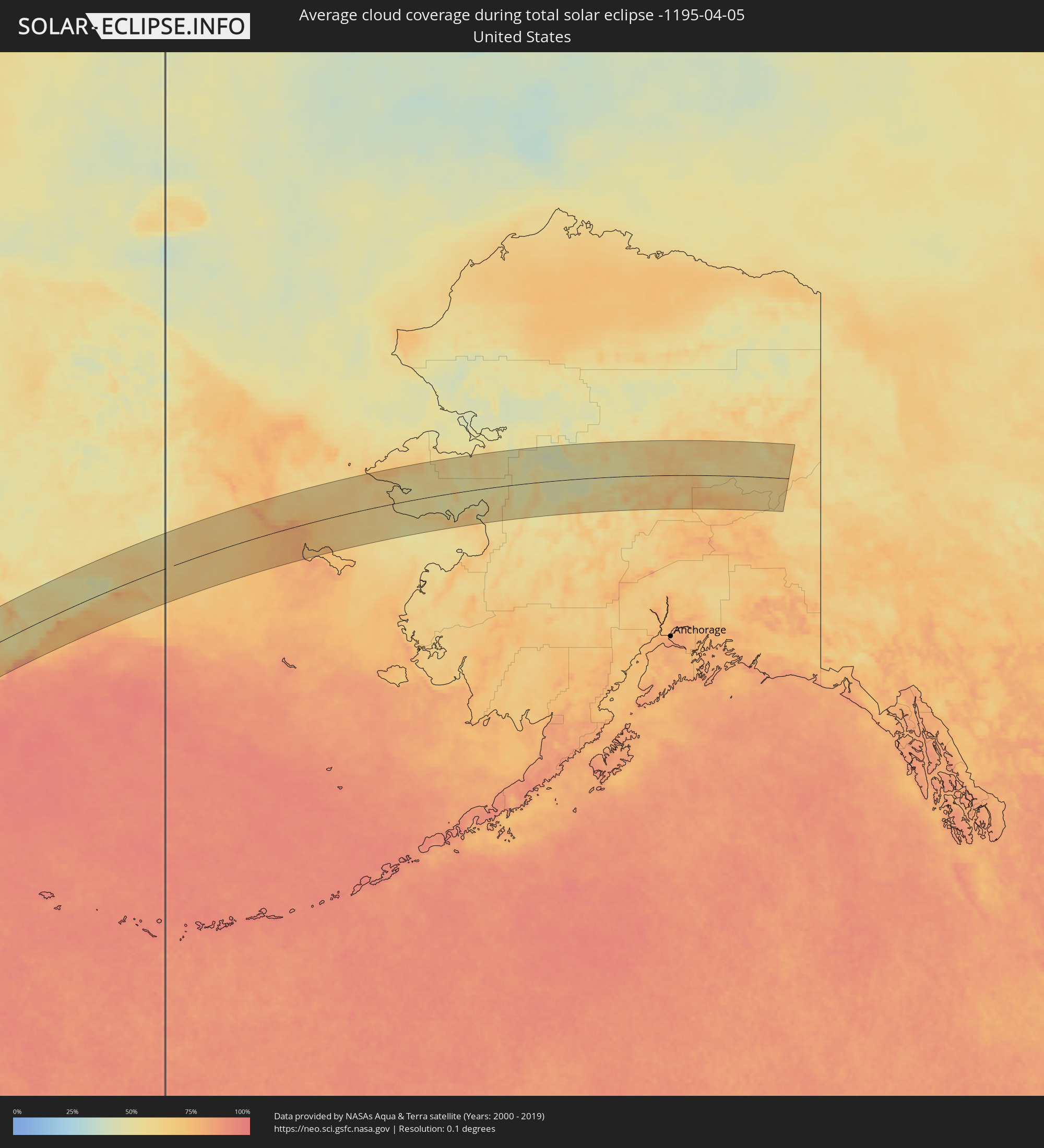 United States
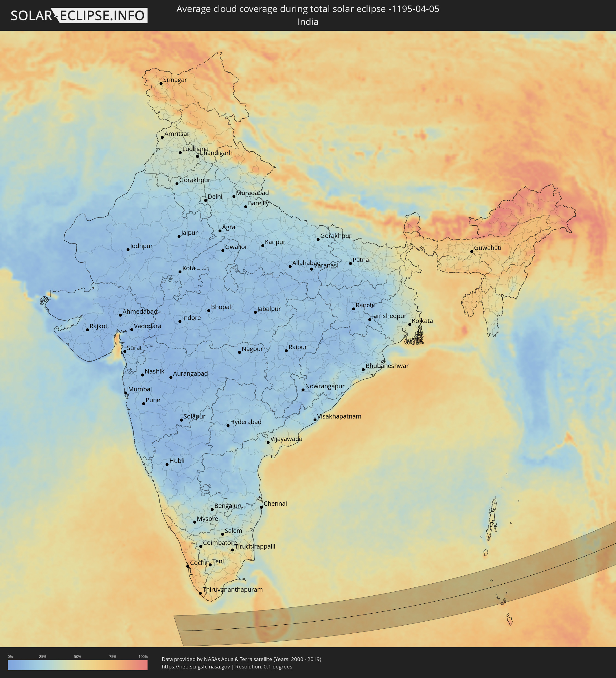 India
India
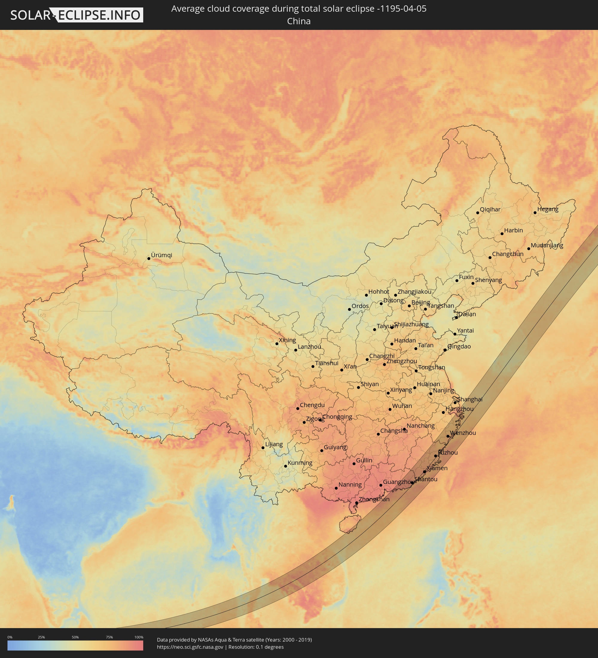 China
China
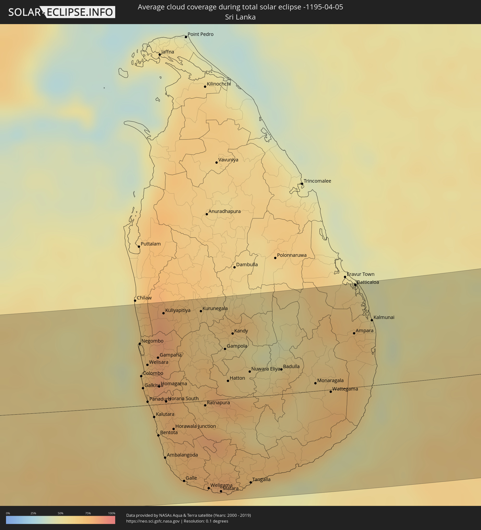 Sri Lanka
 Myanmar
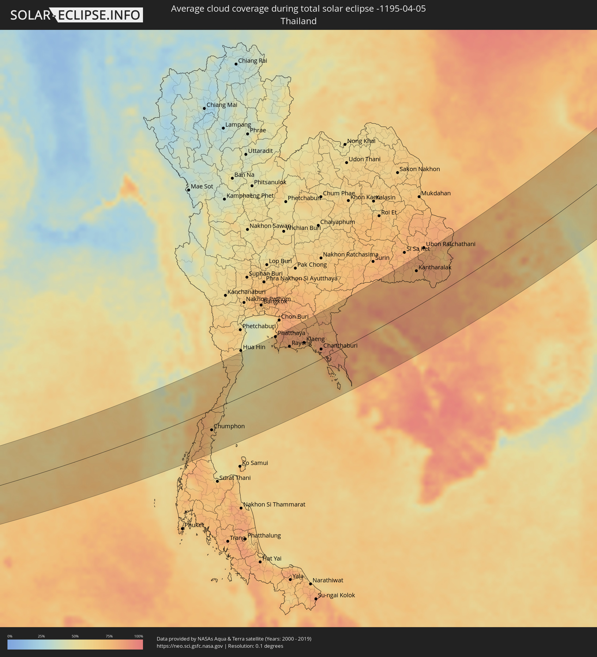 Thailand
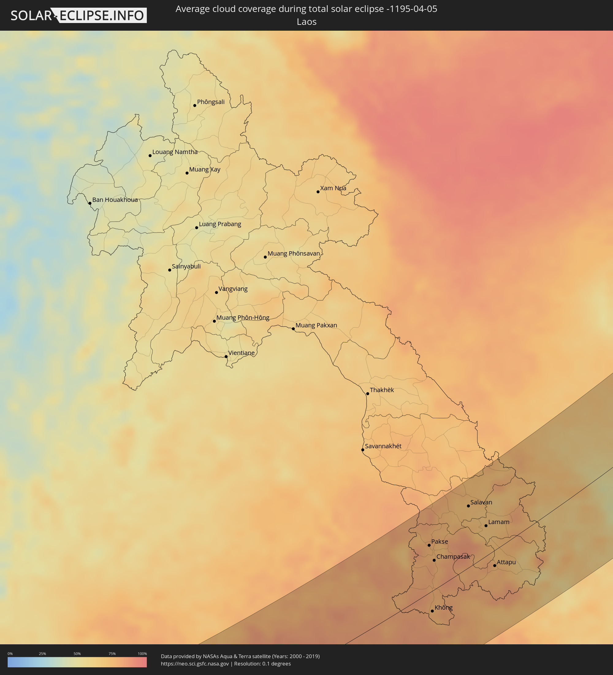 Laos
Laos
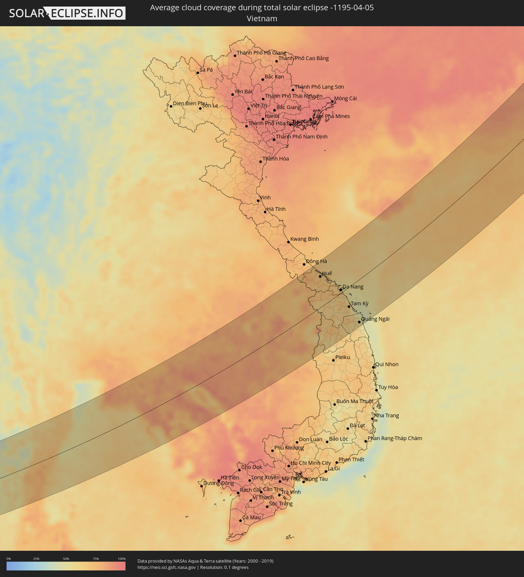 Vietnam
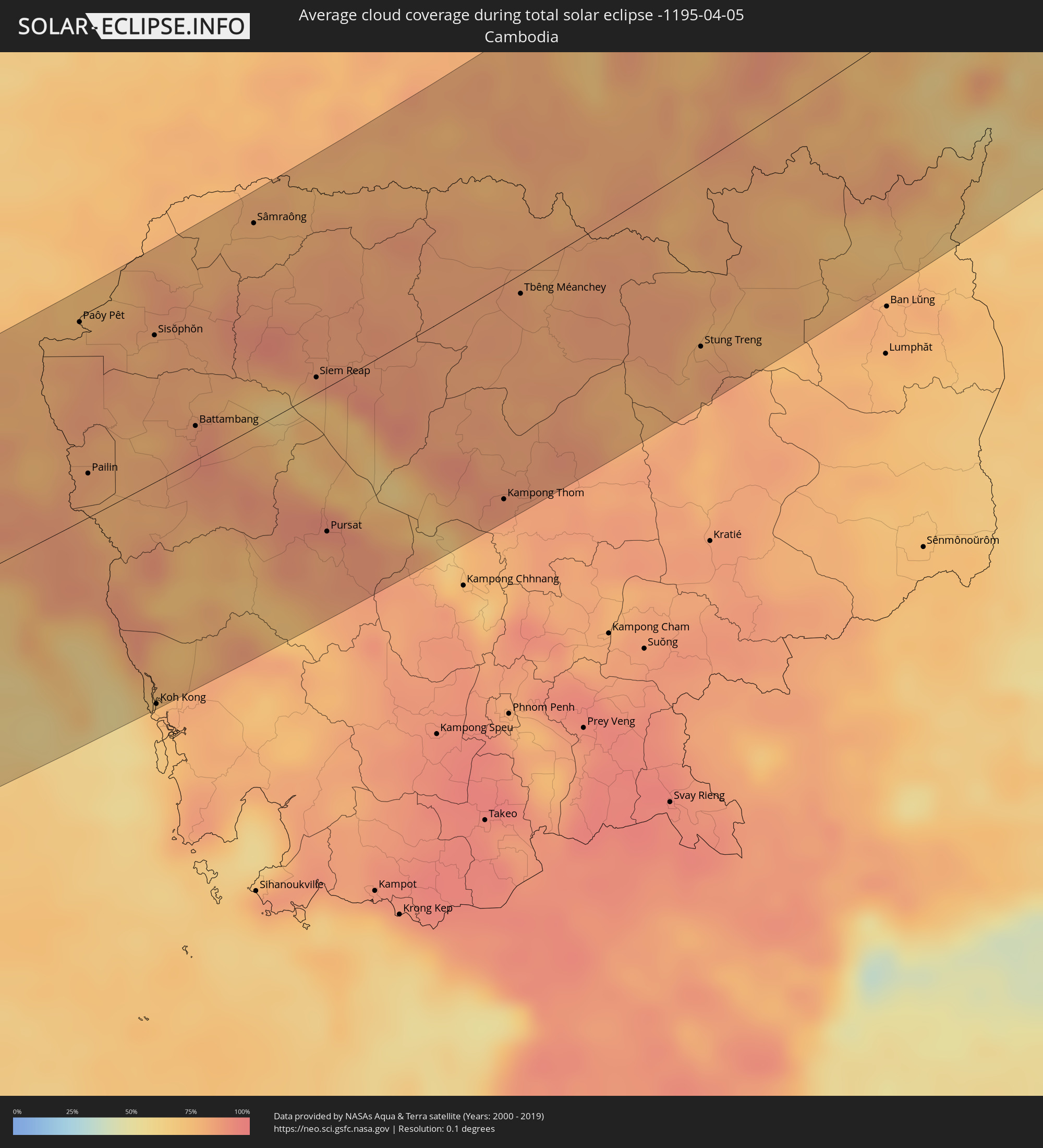 Cambodia
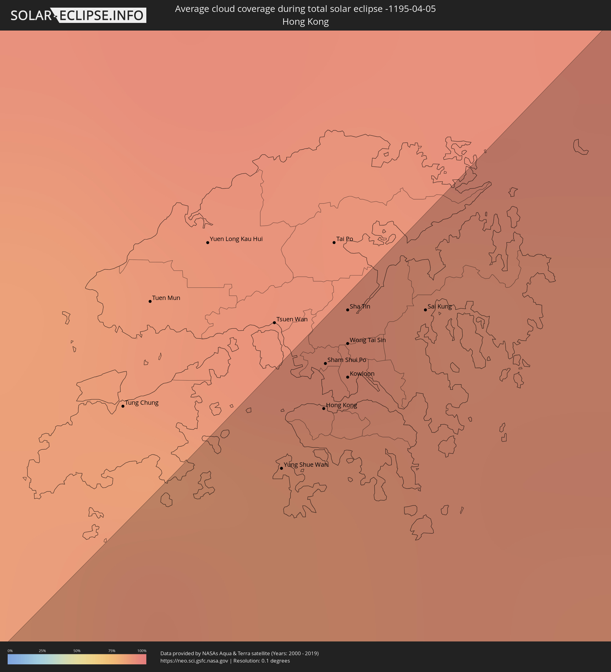 Hong Kong
 Taiwan
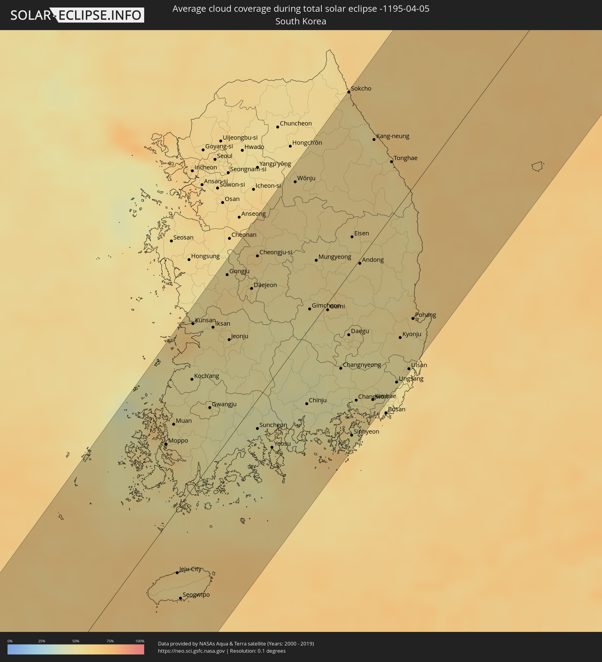 South Korea
Cities inside the path of the eclipse
The following table shows all locations with a population of more than 5,000 inside the eclipse path. Cities which have more than 100,000 inhabitants are marked bold. A click at the locations opens a detailed map.
| City | Type | Eclipse duration | Local time of max. eclipse | Distance to central line | Ø Cloud coverage |
|
College, Alaska
|
total | - | 17:51:13 UTC-10:00 | 73 km | 71% |
|
Fairbanks, Alaska
|
total | - | 17:51:14 UTC-10:00 | 75 km | 64% |
|
Badger, Alaska
|
total | - | 17:51:17 UTC-10:00 | 79 km | 65% |
|
Negombo, Western
|
total | - | 06:22:32 UTC+05:19 | 59 km | 56% |
|
Colombo, Western
|
total | - | 06:22:13 UTC+05:19 | 28 km | 52% |
|
Moratuwa, Western
|
total | - | 06:22:03 UTC+05:19 | 10 km | 60% |
|
Ja Ela, Western
|
total | - | 06:22:23 UTC+05:19 | 43 km | 68% |
|
Kelaniya, Western
|
total | - | 06:22:15 UTC+05:19 | 30 km | 73% |
|
Kalutara, Western
|
total | - | 06:21:50 UTC+05:19 | 12 km | 64% |
|
Bentota, Southern
|
total | - | 06:21:40 UTC+05:19 | 29 km | 54% |
|
Homagama, Western
|
total | - | 06:22:08 UTC+05:19 | 17 km | 75% |
|
Hanwella Ihala, Western
|
total | - | 06:22:12 UTC+05:19 | 22 km | 78% |
|
Galle, Southern
|
total | - | 06:21:15 UTC+05:19 | 75 km | 49% |
|
Kurunegala, North Western
|
total | - | 06:22:54 UTC+05:19 | 85 km | 64% |
|
Ratnapura, Sabaragamuwa
|
total | - | 06:21:59 UTC+05:19 | 5 km | 69% |
|
Matara, Southern
|
total | - | 06:21:11 UTC+05:19 | 87 km | 55% |
|
Gampola, Central
|
total | - | 06:22:33 UTC+05:19 | 47 km | 60% |
|
Kandy, Central
|
total | - | 06:22:43 UTC+05:19 | 61 km | 60% |
|
Nuwara Eliya, Central
|
total | - | 06:22:22 UTC+05:19 | 24 km | 59% |
|
Badulla, Uva
|
total | - | 06:22:25 UTC+05:19 | 23 km | 68% |
|
Batticaloa, Eastern Province
|
total | - | 06:23:21 UTC+05:19 | 97 km | 60% |
|
Kalmunai, Eastern Province
|
total | - | 06:23:01 UTC+05:19 | 62 km | 63% |
|
Ranong, Ranong
|
total | - | 07:56:09 UTC+06:42 | 86 km | 71% |
|
Chumphon, Chumphon
|
total | - | 07:57:21 UTC+06:42 | 54 km | 73% |
|
Prachuap Khiri Khan, Prachuap Khiri Khan
|
total | - | 07:59:54 UTC+06:42 | 55 km | 58% |
|
Kui Buri, Prachuap Khiri Khan
|
total | - | 08:00:22 UTC+06:42 | 78 km | 59% |
|
Sam Roi Yot, Prachuap Khiri Khan
|
total | - | 08:00:41 UTC+06:42 | 96 km | 64% |
|
Pran Buri, Prachuap Khiri Khan
|
total | - | 08:00:54 UTC+06:42 | 107 km | 63% |
|
Phatthaya, Chon Buri
|
total | - | 08:02:35 UTC+06:42 | 116 km | 75% |
|
Sattahip, Chon Buri
|
total | - | 08:02:09 UTC+06:42 | 89 km | 71% |
|
Ban Chang, Rayong
|
total | - | 08:02:23 UTC+06:42 | 87 km | 68% |
|
Rayong, Rayong
|
total | - | 08:02:29 UTC+06:42 | 73 km | 72% |
|
Klaeng, Rayong
|
total | - | 08:02:58 UTC+06:42 | 64 km | 76% |
|
Tha Mai, Chanthaburi
|
total | - | 08:03:00 UTC+06:42 | 31 km | 75% |
|
Chanthaburi, Chanthaburi
|
total | - | 08:03:04 UTC+06:42 | 25 km | 82% |
|
Wang Nam Yen, Sa Kaeo
|
total | - | 08:04:38 UTC+06:42 | 109 km | 78% |
|
Aranyaprathet, Sa Kaeo
|
total | - | 08:05:14 UTC+06:42 | 112 km | 75% |
|
Trat, Trat
|
total | - | 08:02:49 UTC+06:42 | 32 km | 71% |
|
Paôy Pêt, Banteay Meanchey
|
total | - | 08:05:14 UTC+06:42 | 105 km | 76% |
|
Pailin, Pailin
|
total | - | 08:03:55 UTC+06:42 | 23 km | 82% |
|
Sisŏphŏn, Banteay Meanchey
|
total | - | 08:05:29 UTC+06:42 | 77 km | 79% |
|
Koh Kong, Koh Kong
|
total | - | 08:02:11 UTC+06:42 | 117 km | 70% |
|
Battambang, Battambang
|
total | - | 08:04:51 UTC+06:42 | 18 km | 86% |
|
Sâmraông, Ŏtâr Méanchey
|
total | - | 08:06:59 UTC+06:42 | 106 km | 78% |
|
Siem Reap, Siem Reap
|
total | - | 08:05:54 UTC+06:42 | 8 km | 85% |
|
Pursat, Pursat
|
total | - | 08:04:33 UTC+06:42 | 75 km | 83% |
|
Kantharalak, Sisaket
|
total | - | 08:08:51 UTC+06:42 | 88 km | 78% |
|
Kampong Thom, Kampong Thom
|
total | - | 08:05:45 UTC+06:42 | 110 km | 86% |
|
Tbêng Méanchey, Preah Vihear
|
total | - | 08:07:43 UTC+06:42 | 10 km | 83% |
|
Det Udom, Changwat Ubon Ratchathani
|
total | - | 08:09:44 UTC+06:42 | 89 km | 81% |
|
Phibun Mangsahan, Changwat Ubon Ratchathani
|
total | - | 08:10:29 UTC+06:42 | 112 km | 75% |
|
Pakse, Champasak
|
total | - | 08:10:50 UTC+06:42 | 68 km | 77% |
|
Không, Champasak
|
total | - | 08:09:06 UTC+06:42 | 30 km | 78% |
|
Champasak, Champasak
|
total | - | 08:10:30 UTC+06:42 | 42 km | 77% |
|
Stung Treng, Stung Treng
|
total | - | 08:08:11 UTC+06:42 | 92 km | 82% |
|
Salavan, Salavan
|
total | - | 08:12:32 UTC+06:42 | 86 km | 71% |
|
Lamam, Xékong
|
total | - | 08:12:16 UTC+06:42 | 42 km | 69% |
|
Attapu, Attapu
|
total | - | 08:11:20 UTC+06:42 | 22 km | 77% |
|
Huế, Thừa Thiên-Huế
|
total | - | 08:39:43 UTC+07:06 | 83 km | 71% |
|
Da Nang, Đà Nẵng
|
total | - | 08:39:40 UTC+07:06 | 8 km | 72% |
|
Hội An, Quảng Nam
|
total | - | 08:39:27 UTC+07:06 | 16 km | 61% |
|
Tam Kỳ, Quảng Nam
|
total | - | 08:39:02 UTC+07:06 | 53 km | 60% |
|
Quảng Ngãi, Quảng Ngãi
|
total | - | 08:38:33 UTC+07:06 | 114 km | 56% |
|
Sanya, Hainan
|
total | - | 09:38:29 UTC+08:00 | 117 km | 66% |
|
Yung Shue Wan
|
total | - | 09:28:31 UTC+07:36 | 118 km | 85% |
|
Hong Kong, Central and Western
|
total | - | 09:28:42 UTC+07:36 | 119 km | 87% |
|
Central, Central and Western
|
total | - | 09:28:41 UTC+07:36 | 119 km | 87% |
|
Sham Shui Po, Sham Shui Po
|
total | - | 09:28:47 UTC+07:36 | 122 km | 87% |
|
Wan Chai, Wanchai
|
total | - | 09:28:42 UTC+07:36 | 118 km | 87% |
|
Wong Tai Sin, Wong Tai Sin
|
total | - | 09:28:51 UTC+07:36 | 122 km | 87% |
|
Sha Tin, Sha Tin
|
total | - | 09:28:55 UTC+07:36 | 125 km | 87% |
|
Kowloon, Kowloon City
|
total | - | 09:28:47 UTC+07:36 | 120 km | 87% |
|
Sai Kung, Sai Kung
|
total | - | 09:29:02 UTC+07:36 | 119 km | 89% |
|
Shanwei, Guangdong
|
total | - | 09:54:31 UTC+08:00 | 69 km | 84% |
|
Donghai, Guangdong
|
total | - | 09:55:14 UTC+08:00 | 59 km | 85% |
|
Jieshi, Guangdong
|
total | - | 09:55:13 UTC+08:00 | 35 km | 79% |
|
Meizhou, Guangdong
|
total | - | 09:58:32 UTC+08:00 | 125 km | 84% |
|
Jieyang, Guangdong
|
total | - | 09:57:23 UTC+08:00 | 49 km | 89% |
|
Chaozhou, Guangdong
|
total | - | 09:57:57 UTC+08:00 | 38 km | 89% |
|
Shantou, Guangdong
|
total | - | 09:57:30 UTC+08:00 | 10 km | 81% |
|
Huanggang, Guangdong
|
total | - | 09:58:30 UTC+08:00 | 11 km | 82% |
|
Zhangzhou, Fujian
|
total | - | 10:01:04 UTC+08:00 | 23 km | 84% |
|
Xiamen, Fujian
|
total | - | 10:01:35 UTC+08:00 | 12 km | 81% |
|
Jincheng, Fukien
|
total | - | 10:01:49 UTC+08:00 | 34 km | 75% |
|
Quanzhou, Fujian
|
total | - | 10:03:08 UTC+08:00 | 20 km | 84% |
|
Putian, Fujian
|
total | - | 10:04:46 UTC+08:00 | 15 km | 82% |
|
Fuzhou, Fujian
|
total | - | 10:06:25 UTC+08:00 | 7 km | 79% |
|
Wenzhou, Zhejiang
|
total | - | 10:12:10 UTC+08:00 | 37 km | 77% |
|
Linhai, Zhejiang
|
total | - | 10:14:29 UTC+08:00 | 59 km | 73% |
|
Huangyan, Zhejiang
|
total | - | 10:14:17 UTC+08:00 | 35 km | 76% |
|
Jiaojiang, Zhejiang
|
total | - | 10:14:36 UTC+08:00 | 23 km | 77% |
|
Ningbo, Zhejiang
|
total | - | 10:17:05 UTC+08:00 | 96 km | 73% |
|
Moppo, Jeollanam-do
|
total | - | 11:01:02 UTC+08:27 | 52 km | 59% |
|
Jeju City, Jeju-do
|
total | - | 10:58:55 UTC+08:27 | 42 km | 58% |
|
Kunsan, Jeollabuk-do
|
total | - | 11:03:34 UTC+08:27 | 105 km | 54% |
|
Gwangju, Gwangju
|
total | - | 11:02:25 UTC+08:27 | 37 km | 52% |
|
Iksan, Jeollabuk-do
|
total | - | 11:03:51 UTC+08:27 | 85 km | 55% |
|
Jeonju, Jeollabuk-do
|
total | - | 11:03:55 UTC+08:27 | 63 km | 54% |
|
Daejeon, Daejeon
|
total | - | 11:05:10 UTC+08:27 | 76 km | 55% |
|
Suncheon, Jeollanam-do
|
total | - | 11:02:53 UTC+08:27 | 19 km | 51% |
|
Cheongju-si, Chungcheongbuk-do
|
total | - | 11:05:48 UTC+08:27 | 91 km | 55% |
|
Yeosu, Jeollanam-do
|
total | - | 11:02:49 UTC+08:27 | 44 km | 52% |
|
Wŏnju, Gangwon-do
|
total | - | 11:07:39 UTC+08:27 | 105 km | 57% |
|
Chinju, Gyeongsangnam-do
|
total | - | 11:04:11 UTC+08:27 | 47 km | 48% |
|
Gumi, Gyeongsangbuk-do
|
total | - | 11:06:07 UTC+08:27 | 4 km | 54% |
|
Daegu, Daegu
|
total | - | 11:06:05 UTC+08:27 | 39 km | 53% |
|
Changwon, Gyeongsangnam-do
|
total | - | 11:05:06 UTC+08:27 | 88 km | 56% |
|
Kimhae, Gyeongsangnam-do
|
total | - | 11:05:24 UTC+08:27 | 102 km | 55% |
|
Kang-neung, Gangwon-do
|
total | - | 11:09:40 UTC+08:27 | 63 km | 55% |
|
Ulsan, Ulsan
|
total | - | 11:06:33 UTC+08:27 | 114 km | 55% |
|
Pohang, Gyeongsangbuk-do
|
total | - | 11:07:28 UTC+08:27 | 84 km | 55% |
|
Vrangel’, Primorskiy
|
total | - | 11:42:34 UTC+08:47 | 108 km | 62% |
|
Preobrazheniye, Primorskiy
|
total | - | 11:43:55 UTC+08:47 | 66 km | 64% |
|
Kavalerovo, Primorskiy
|
total | - | 11:47:12 UTC+08:47 | 88 km | 71% |
|
Dal'negorsk, Primorskiy
|
total | - | 11:48:14 UTC+08:47 | 75 km | 76% |
|
Plastun, Primorskiy
|
total | - | 11:49:24 UTC+08:47 | 46 km | 66% |
|
Uglegorsk, Sakhalin
|
total | - | 13:28:22 UTC+10:14 | 29 km | 79% |
|
Shakhtersk, Sakhalin
|
total | - | 13:28:31 UTC+10:14 | 32 km | 78% |
|
Makarov, Sakhalin
|
total | - | 13:28:50 UTC+10:14 | 44 km | 82% |
|
Smirnykh, Sakhalin
|
total | - | 13:29:48 UTC+10:14 | 38 km | 87% |
|
Poronaysk, Sakhalin
|
total | - | 13:29:42 UTC+10:14 | 16 km | 80% |