Total solar eclipse of 06/27/-1265
| Day of week: | Wednesday |
| Maximum duration of eclipse: | 05m39s |
| Maximum width of eclipse path: | 279 km |
| Saros cycle: | 26 |
| Coverage: | 100% |
| Magnitude: | 1.0773 |
| Gamma: | 0.4405 |
Wo kann man die Sonnenfinsternis vom 06/27/-1265 sehen?
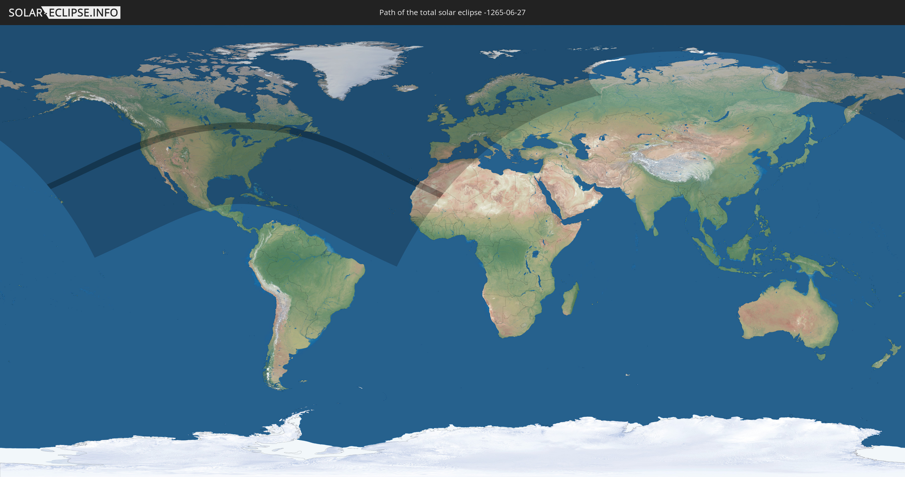
Die Sonnenfinsternis am 06/27/-1265 kann man in 83 Ländern als partielle Sonnenfinsternis beobachten.
Der Finsternispfad verläuft durch 6 Länder. Nur in diesen Ländern ist sie als total Sonnenfinsternis zu sehen.
In den folgenden Ländern ist die Sonnenfinsternis total zu sehen
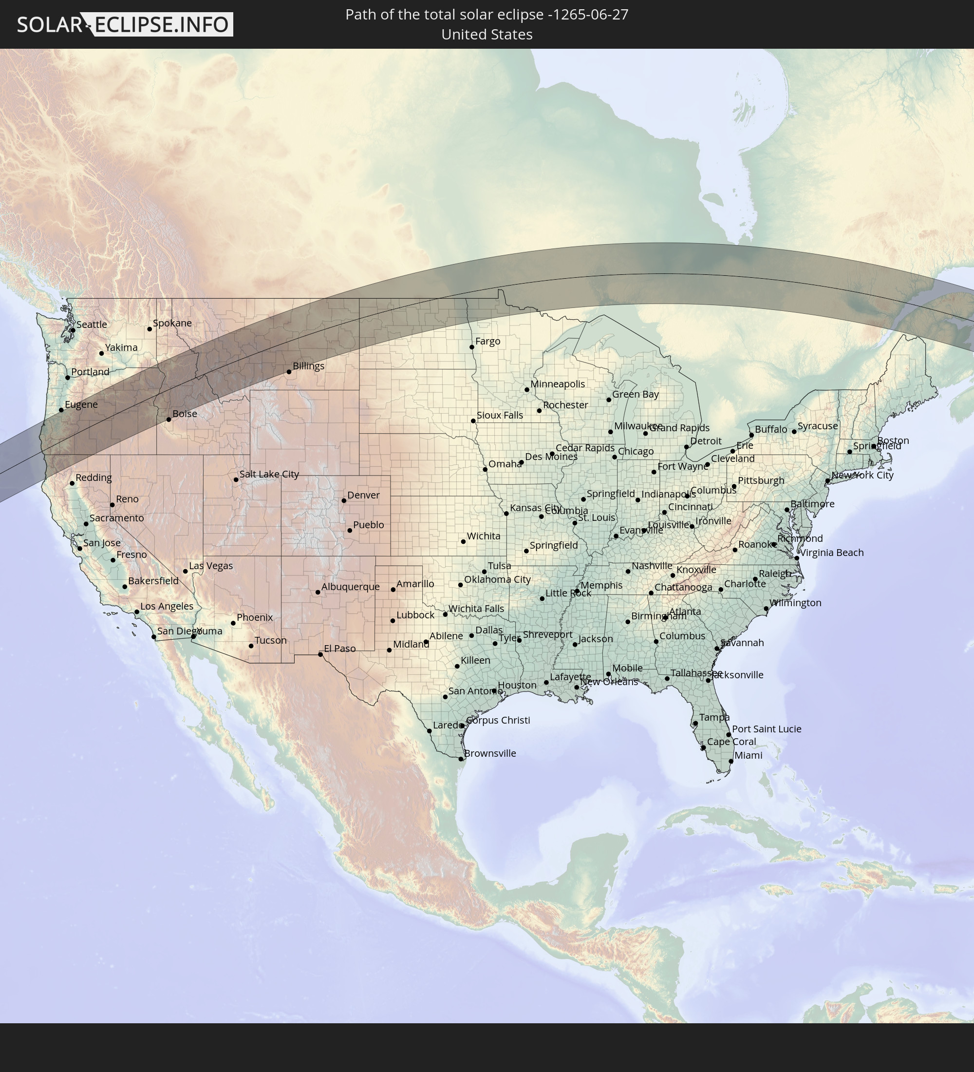 United States
 Canada
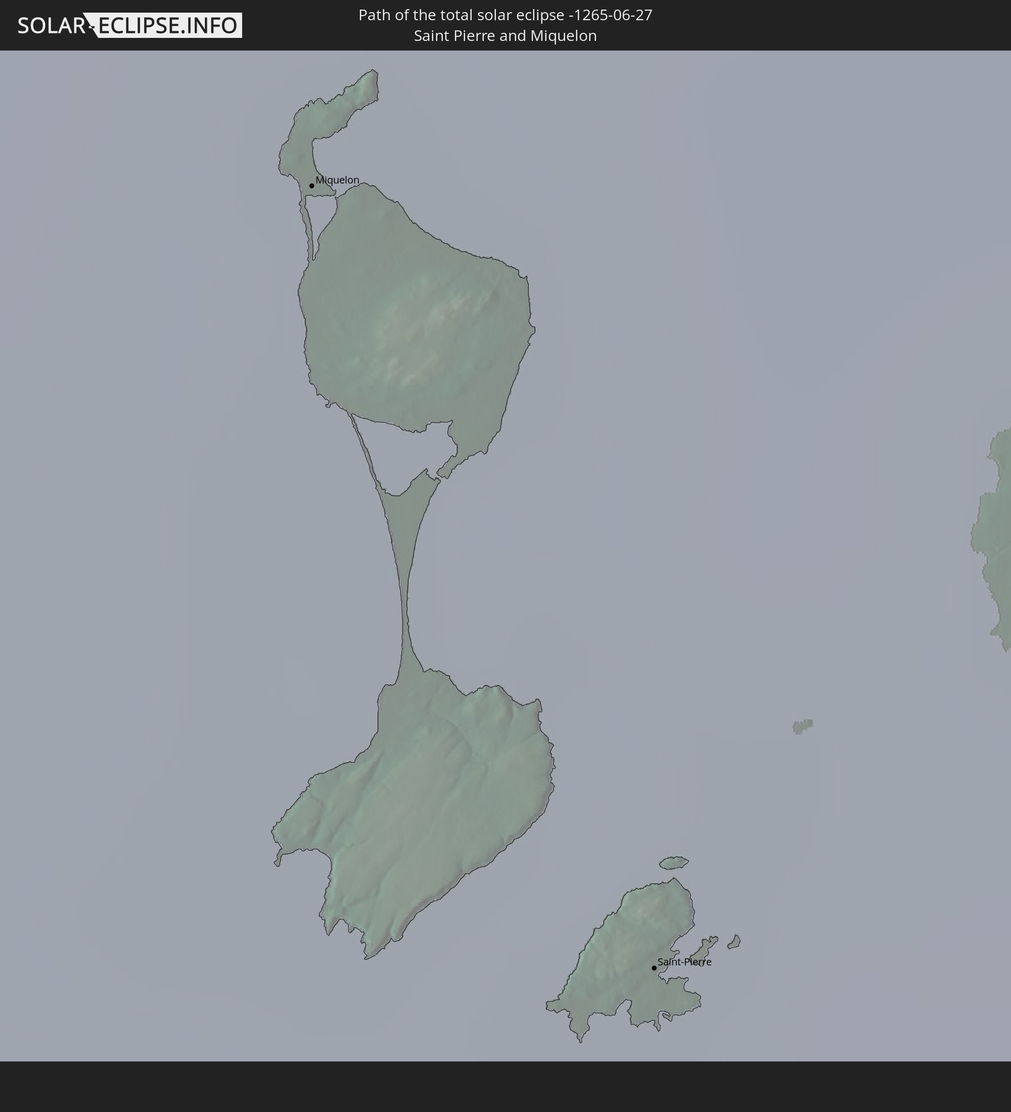 Saint Pierre and Miquelon
 Spain
Spain
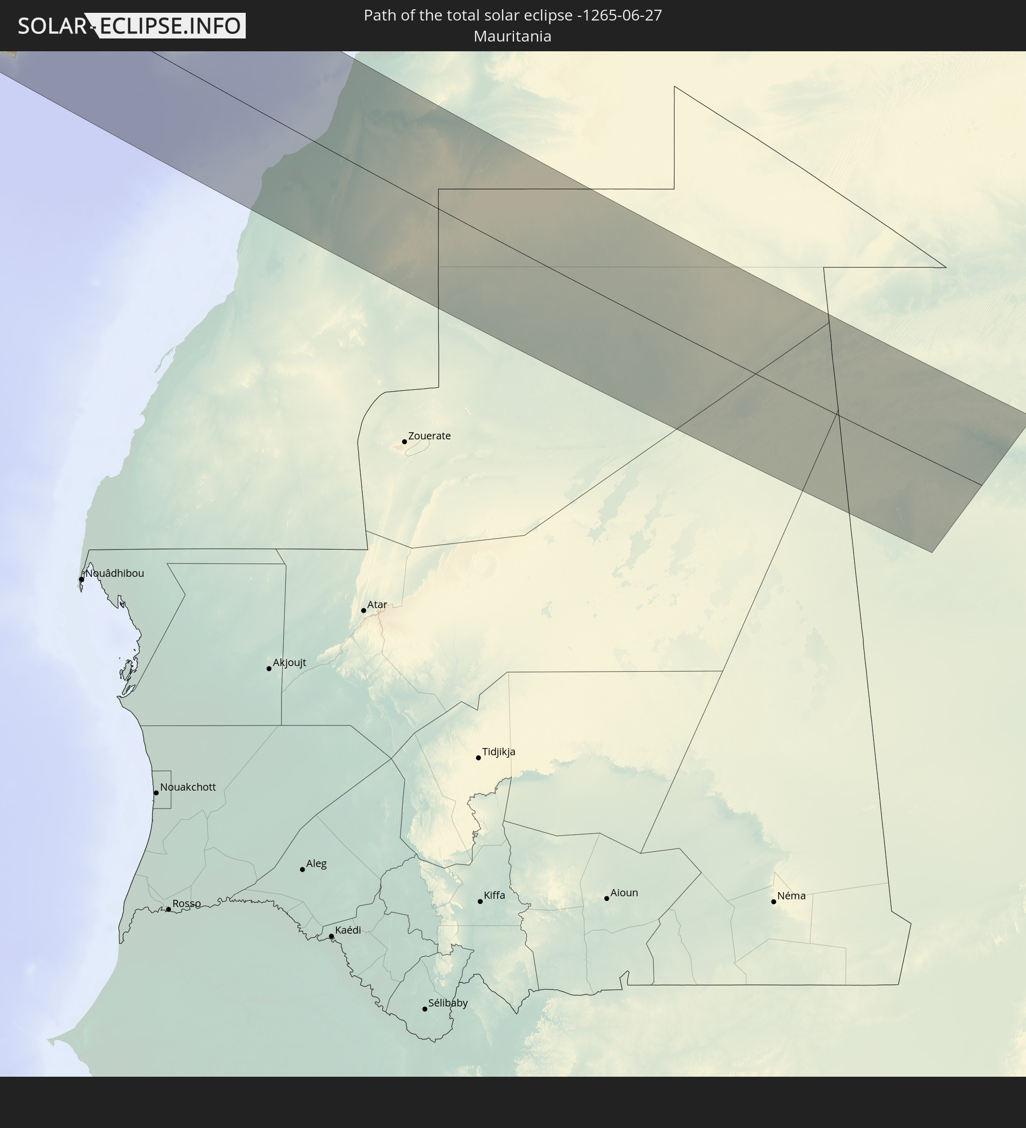 Mauritania
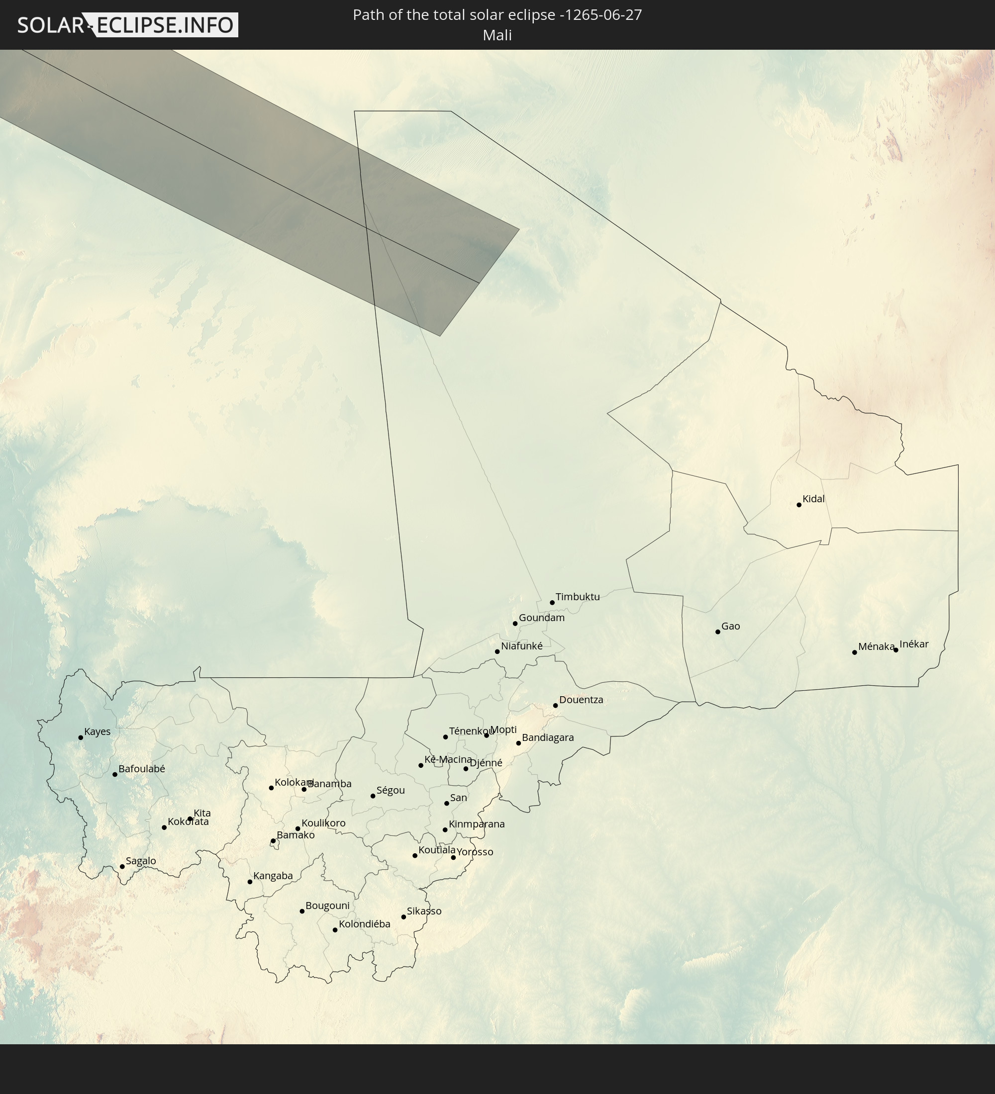 Mali
Mali
In den folgenden Ländern ist die Sonnenfinsternis partiell zu sehen
 Russia
 United States
 United States Minor Outlying Islands
 Canada
 Mexico
 Greenland
 Cuba
Cuba
 Cayman Islands
 The Bahamas
 Jamaica
 Haiti
Haiti
 Turks and Caicos Islands
 Dominican Republic
 Puerto Rico
 United States Virgin Islands
 Bermuda
 British Virgin Islands
 Anguilla
 Collectivity of Saint Martin
 Saint Barthélemy
 Saint Kitts and Nevis
 Antigua and Barbuda
 Montserrat
 Guadeloupe
 Dominica
 Saint Vincent and the Grenadines
 Martinique
 Saint Lucia
 Barbados
 Saint Pierre and Miquelon
 Portugal
 Cabo Verde
 Iceland
 Spain
Spain
 Senegal
 Mauritania
 The Gambia
 Guinea-Bissau
 Guinea
 Morocco
 Mali
Mali
 Republic of Ireland
 Svalbard and Jan Mayen
 Algeria
 United Kingdom
 Faroe Islands
 Gibraltar
 France
 Isle of Man
 Guernsey
 Jersey
 Andorra
 Belgium
 Netherlands
 Norway
 Luxembourg
 Germany
 Switzerland
 Italy
Italy
 Monaco
 Tunisia
 Denmark
 Liechtenstein
 Austria
 Sweden
 Czechia
 San Marino
 Vatican City
 Slovenia
 Croatia
 Poland
 Bosnia and Herzegovina
 Hungary
 Slovakia
 Serbia
 Åland Islands
 Romania
 Finland
 Lithuania
 Latvia
 Estonia
 Ukraine
 Belarus
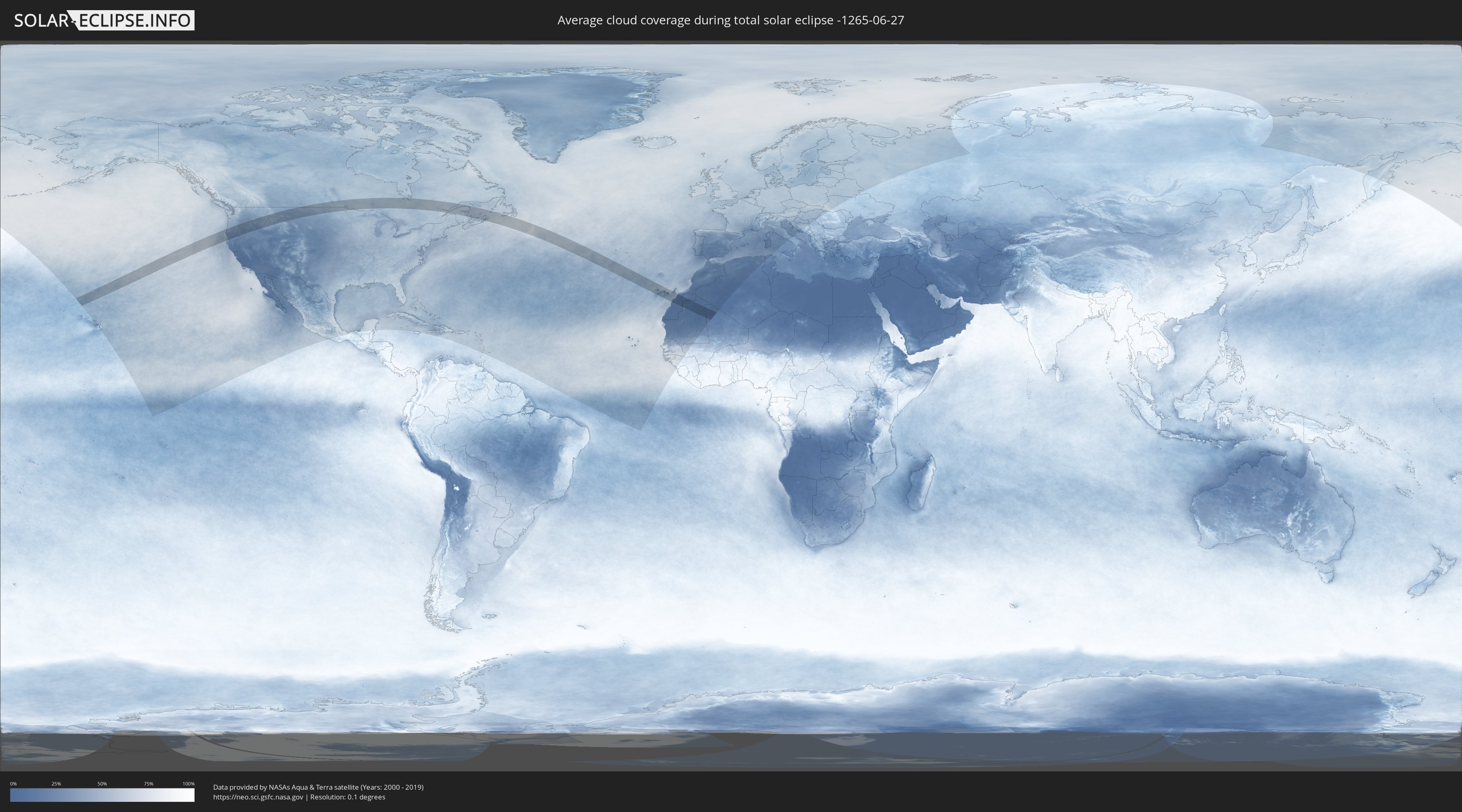
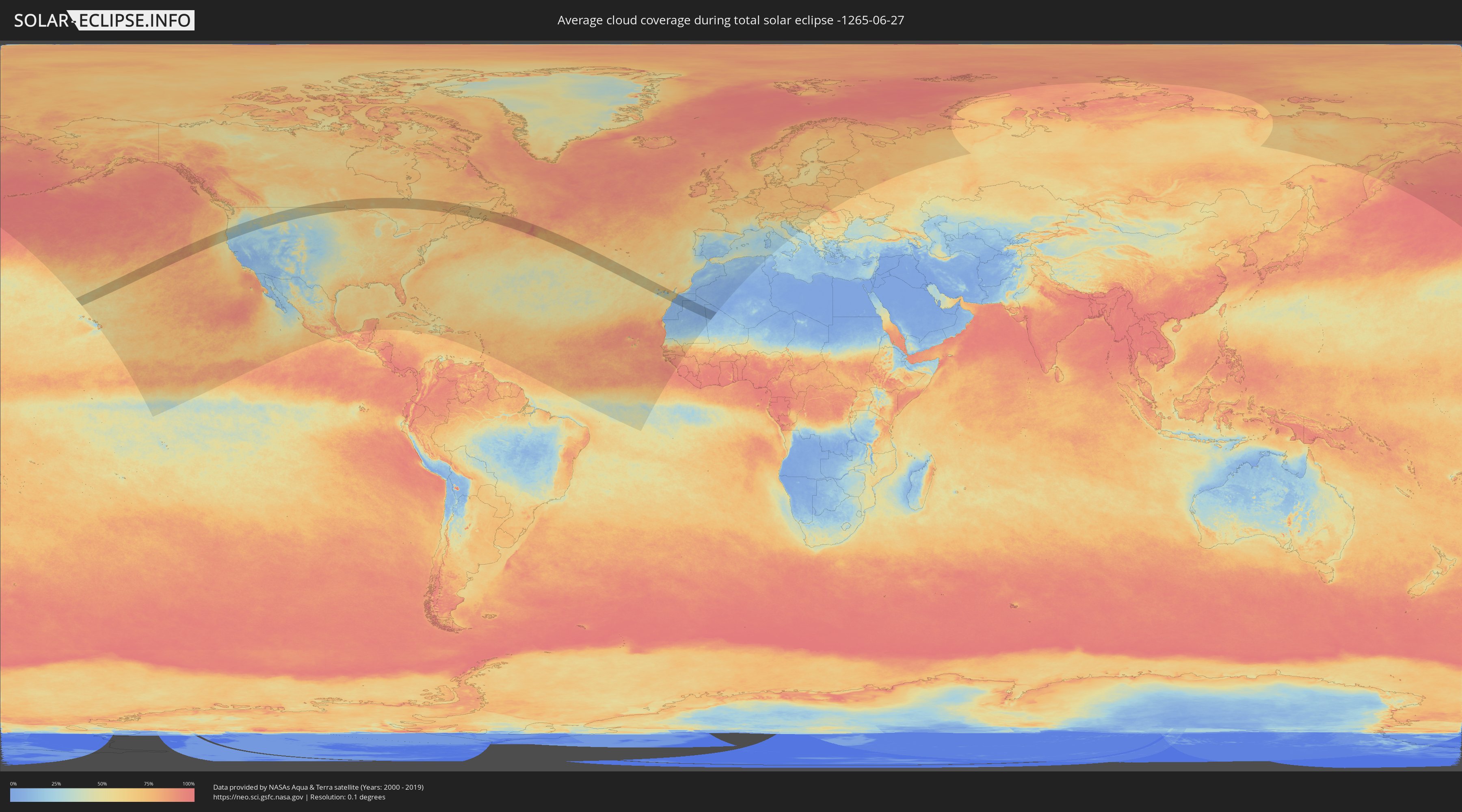
How will be the weather during the total solar eclipse on 06/27/-1265?
Where is the best place to see the total solar eclipse of 06/27/-1265?
The following maps show the average cloud coverage for the day of the total solar eclipse.
With the help of these maps, it is possible to find the place along the eclipse path, which has the best
chance of a cloudless sky.
Nevertheless, you should consider local circumstances and inform about the weather of your chosen
observation site.
The data is provided by NASAs satellites
AQUA and TERRA.
The cloud maps are averaged over a period of 19 years (2000 - 2019).
Detailed country maps
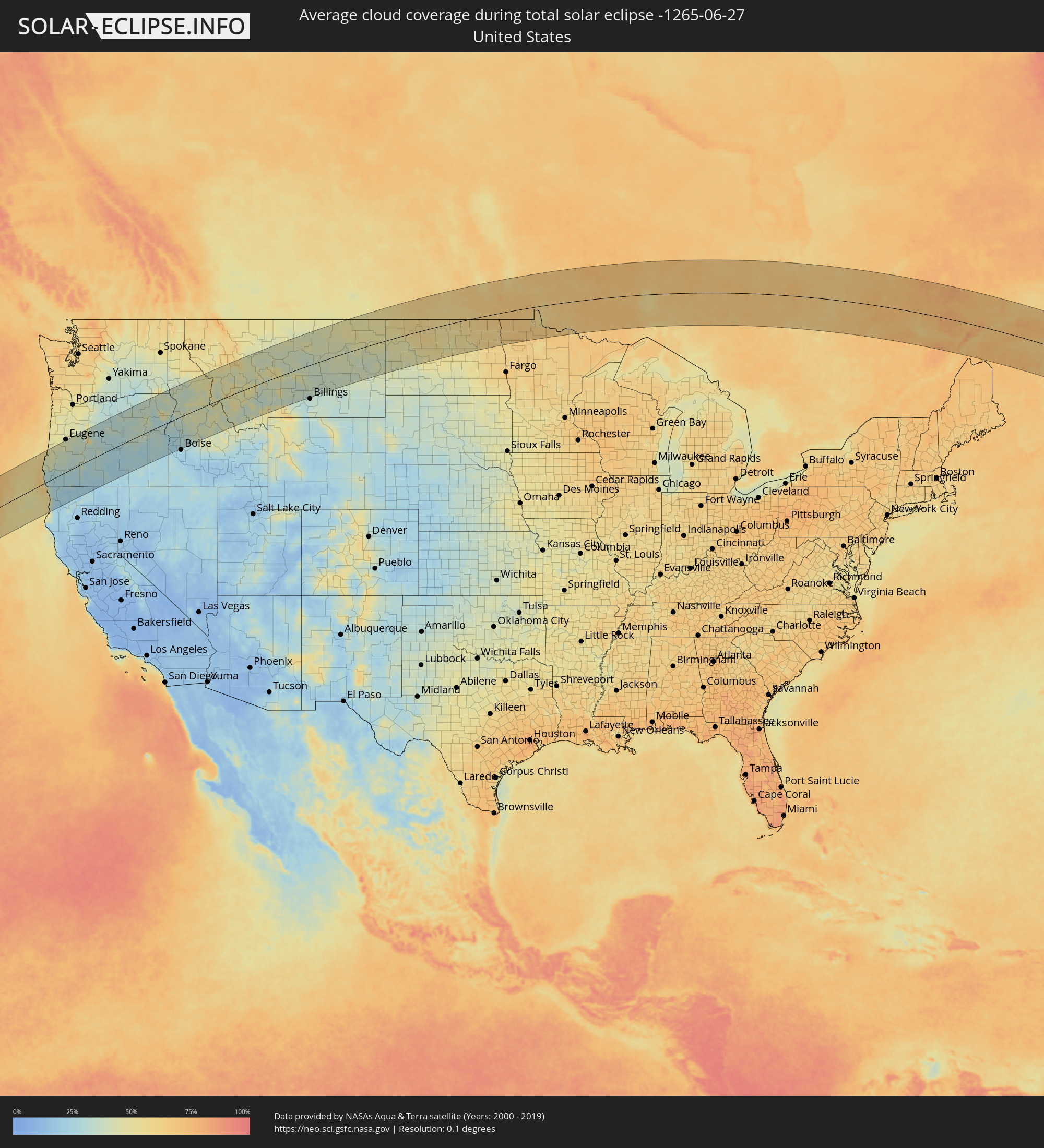 United States
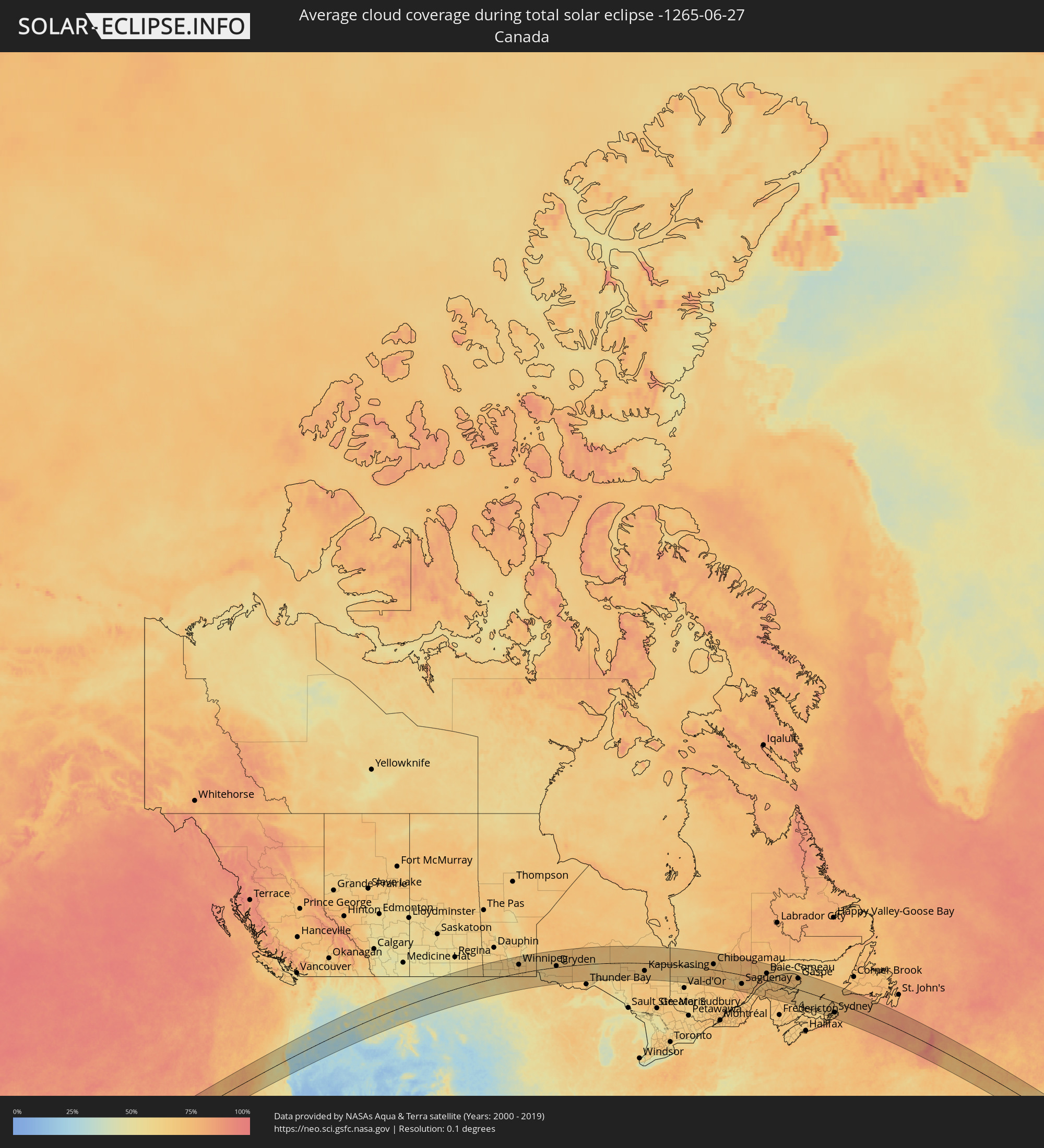 Canada
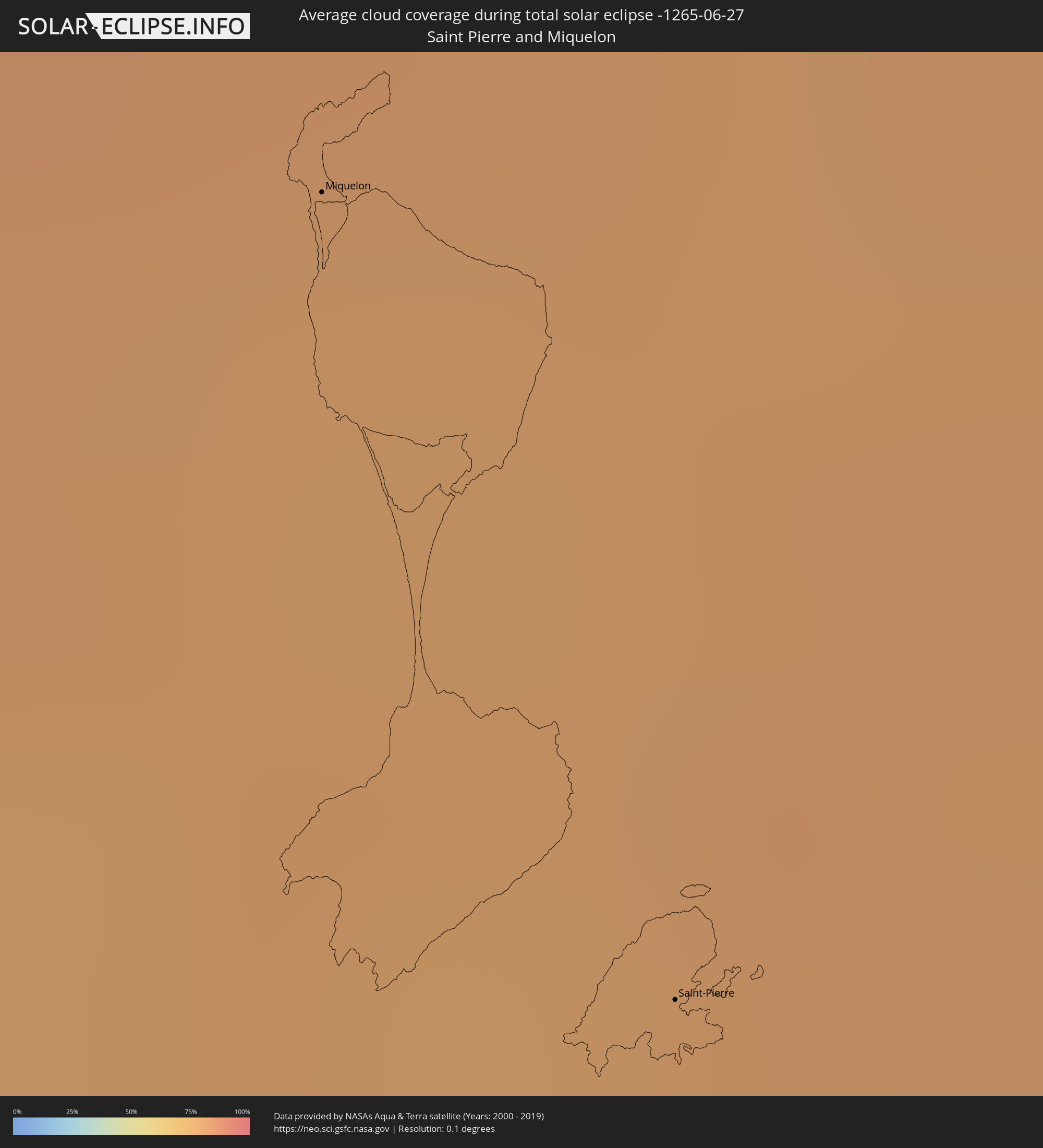 Saint Pierre and Miquelon
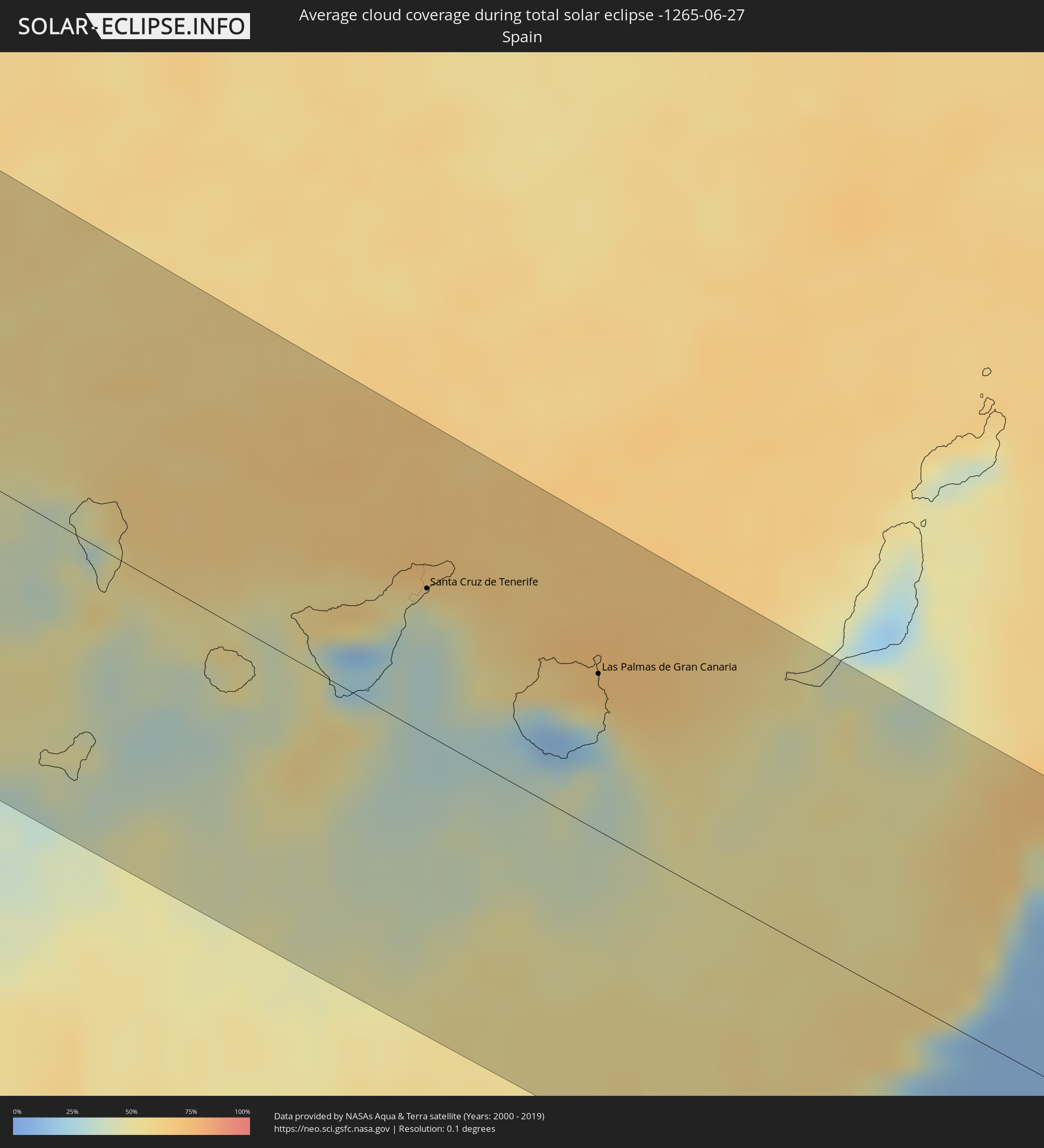 Spain
Spain
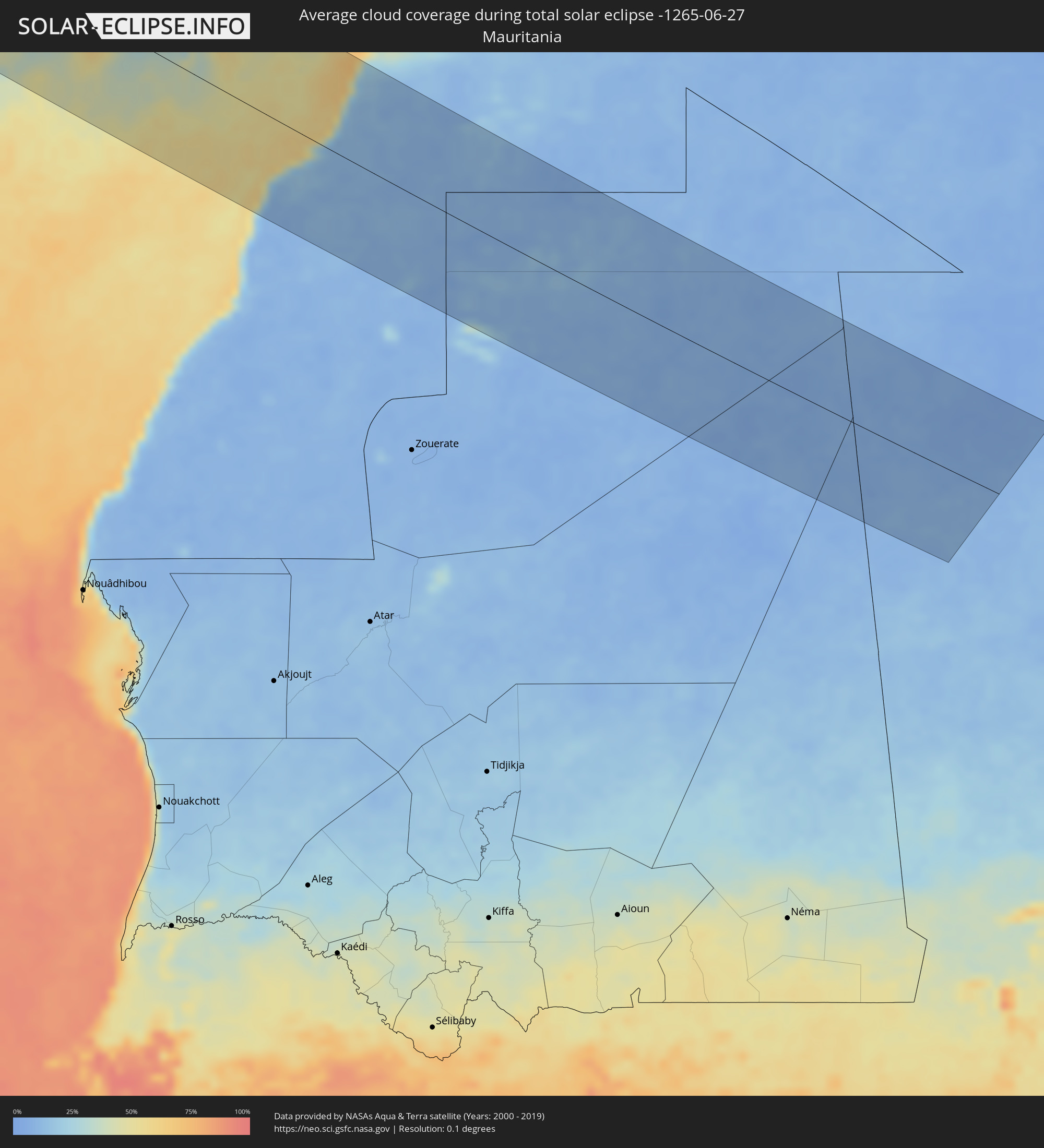 Mauritania
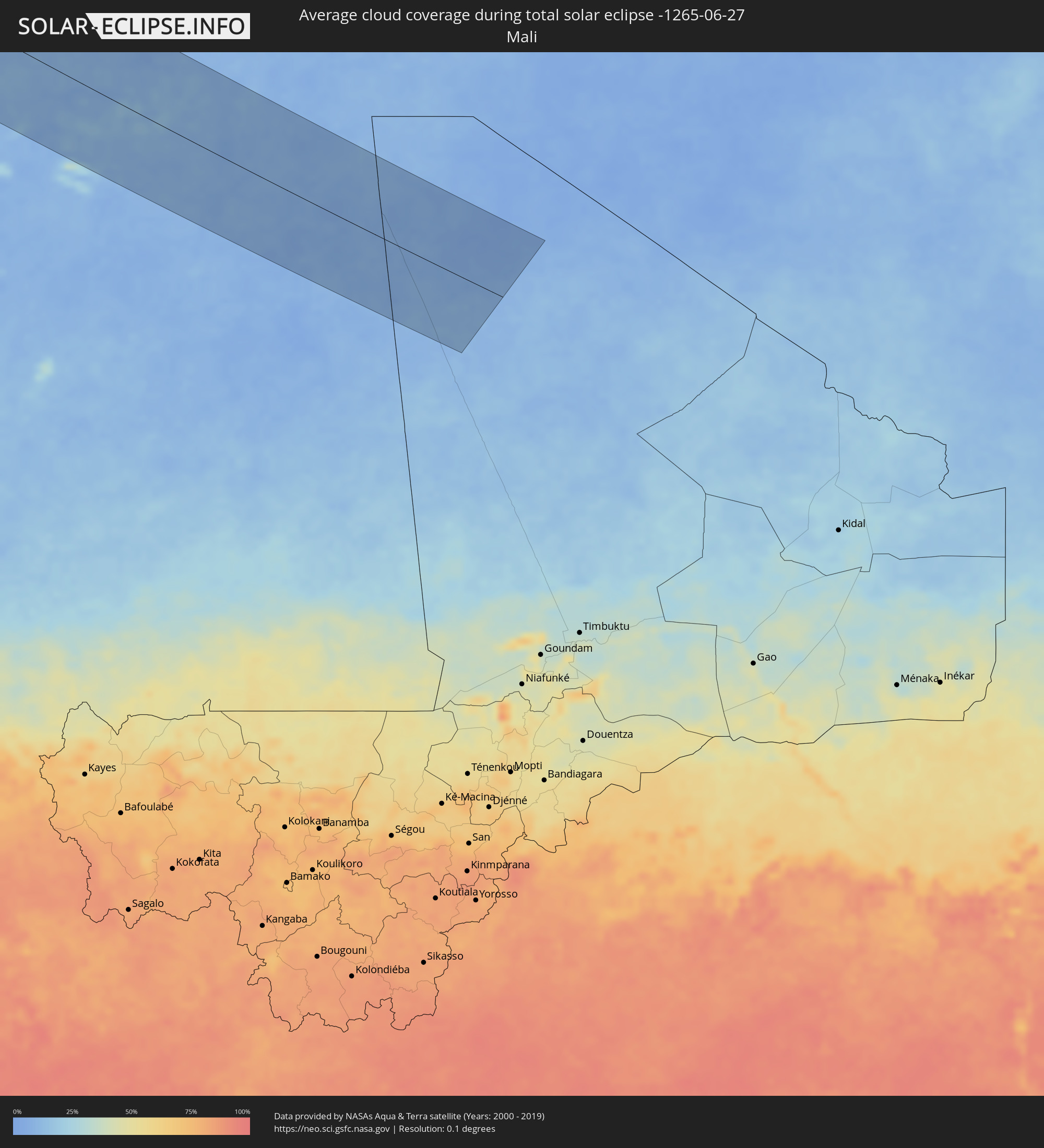 Mali
Mali
Cities inside the path of the eclipse
The following table shows all locations with a population of more than 5,000 inside the eclipse path. Cities which have more than 100,000 inhabitants are marked bold. A click at the locations opens a detailed map.
| City | Type | Eclipse duration | Local time of max. eclipse | Distance to central line | Ø Cloud coverage |
|
North Bend, Oregon
|
total | - | 08:13:55 UTC-08:00 | 118 km | 42% |
|
Coos Bay, Oregon
|
total | - | 08:13:52 UTC-08:00 | 114 km | 42% |
|
Crescent City, California
|
total | - | 08:11:36 UTC-08:00 | 46 km | 51% |
|
McKinleyville, California
|
total | - | 08:10:33 UTC-08:00 | 130 km | 50% |
|
Roseburg, Oregon
|
total | - | 08:14:19 UTC-08:00 | 66 km | 40% |
|
Grants Pass, Oregon
|
total | - | 08:13:14 UTC-08:00 | 11 km | 29% |
|
Sutherlin, Oregon
|
total | - | 08:14:35 UTC-08:00 | 82 km | 39% |
|
Cottage Grove, Oregon
|
total | - | 08:15:21 UTC-08:00 | 113 km | 42% |
|
Springfield, Oregon
|
total | - | 08:15:44 UTC-08:00 | 136 km | 42% |
|
Medford, Oregon
|
total | - | 08:13:26 UTC-08:00 | 39 km | 28% |
|
White City, Oregon
|
total | - | 08:13:36 UTC-08:00 | 29 km | 27% |
|
Eagle Point, Oregon
|
total | - | 08:13:42 UTC-08:00 | 28 km | 25% |
|
Ashland, Oregon
|
total | - | 08:13:23 UTC-08:00 | 59 km | 29% |
|
Yreka, California
|
total | - | 08:12:48 UTC-08:00 | 107 km | 24% |
|
Klamath Falls, Oregon
|
total | - | 08:14:11 UTC-08:00 | 90 km | 24% |
|
Bend, Oregon
|
total | - | 08:17:08 UTC-08:00 | 76 km | 32% |
|
Redmond, Oregon
|
total | - | 08:17:34 UTC-08:00 | 92 km | 27% |
|
Prineville, Oregon
|
total | - | 08:17:53 UTC-08:00 | 83 km | 30% |
|
La Grande, Oregon
|
total | - | 08:21:47 UTC-08:00 | 91 km | 36% |
|
Baker City, Oregon
|
total | - | 08:21:16 UTC-08:00 | 27 km | 29% |
|
Ontario, Oregon
|
total | - | 09:21:07 UTC-07:00 | 78 km | 27% |
|
Caldwell, Idaho
|
total | - | 09:20:54 UTC-07:00 | 124 km | 25% |
|
Eagle, Idaho
|
total | - | 09:21:17 UTC-07:00 | 131 km | 24% |
|
Missoula, Montana
|
total | - | 09:27:58 UTC-07:00 | 120 km | 45% |
|
Anaconda, Montana
|
total | - | 09:28:09 UTC-07:00 | 12 km | 46% |
|
Butte, Montana
|
total | - | 09:28:27 UTC-07:00 | 13 km | 43% |
|
Helena Valley West Central, Montana
|
total | - | 09:29:49 UTC-07:00 | 42 km | 41% |
|
Helena, Montana
|
total | - | 09:29:45 UTC-07:00 | 34 km | 42% |
|
Helena Valley Southeast, Montana
|
total | - | 09:29:55 UTC-07:00 | 33 km | 42% |
|
Great Falls, Montana
|
total | - | 09:31:44 UTC-07:00 | 108 km | 39% |
|
Bozeman, Montana
|
total | - | 09:29:46 UTC-07:00 | 89 km | 35% |
|
Williston, North Dakota
|
total | - | 10:42:05 UTC-06:00 | 8 km | 47% |
|
Estevan, Saskatchewan
|
total | - | 09:45:19 UTC-06:58 | 85 km | 55% |
|
Minot, North Dakota
|
total | - | 10:45:24 UTC-06:00 | 44 km | 59% |
|
Brandon, Manitoba
|
total | - | 10:48:44 UTC-06:00 | 108 km | 60% |
|
Portage la Prairie, Manitoba
|
total | - | 10:51:10 UTC-06:00 | 96 km | 63% |
|
Morden, Manitoba
|
total | - | 10:50:50 UTC-06:00 | 8 km | 63% |
|
Winkler, Manitoba
|
total | - | 10:51:03 UTC-06:00 | 5 km | 64% |
|
Winnipeg, Manitoba
|
total | - | 10:52:45 UTC-06:00 | 70 km | 72% |
|
Selkirk, Manitoba
|
total | - | 10:53:19 UTC-06:00 | 95 km | 65% |
|
Steinbach, Manitoba
|
total | - | 10:53:10 UTC-06:00 | 25 km | 69% |
|
Thief River Falls, Minnesota
|
total | - | 10:52:56 UTC-06:00 | 136 km | 63% |
|
Fort Frances, Ontario
|
total | - | 10:57:37 UTC-06:00 | 115 km | 64% |
|
Dryden, Ontario
|
total | - | 10:59:17 UTC-06:00 | 10 km | 67% |
|
Kapuskasing, Ontario
|
total | - | 12:15:49 UTC-05:00 | 65 km | 71% |
|
La Sarre, Quebec
|
total | - | 12:21:18 UTC-05:00 | 120 km | 62% |
|
Amos, Quebec
|
total | - | 12:23:11 UTC-05:00 | 139 km | 60% |
|
Chibougamau, Quebec
|
total | - | 12:28:47 UTC-05:00 | 45 km | 72% |
|
Saint-Félicien, Quebec
|
total | - | 12:32:31 UTC-05:00 | 70 km | 66% |
|
Roberval, Quebec
|
total | - | 12:32:57 UTC-05:00 | 82 km | 67% |
|
Dolbeau-Mistassini, Quebec
|
total | - | 12:32:44 UTC-05:00 | 42 km | 67% |
|
Pont Rouge, Quebec
|
total | - | 12:32:58 UTC-05:00 | 39 km | 67% |
|
Alma, Quebec
|
total | - | 12:33:52 UTC-05:00 | 70 km | 65% |
|
Jonquière, Quebec
|
total | - | 12:34:36 UTC-05:00 | 78 km | 68% |
|
Saguenay, Quebec
|
total | - | 12:34:53 UTC-05:00 | 76 km | 68% |
|
Rivière-du-Loup, Quebec
|
total | - | 12:37:45 UTC-05:00 | 115 km | 67% |
|
Rimouski, Quebec
|
total | - | 12:38:52 UTC-05:00 | 30 km | 65% |
|
Mont-Joli, Quebec
|
total | - | 12:39:17 UTC-05:00 | 10 km | 65% |
|
Baie-Comeau, Quebec
|
total | - | 12:38:50 UTC-05:00 | 60 km | 73% |
|
Matane, Quebec
|
total | - | 12:40:06 UTC-05:00 | 29 km | 66% |
|
Campbellton, New Brunswick
|
total | - | 13:27:41 UTC-04:14 | 43 km | 69% |
|
Bathurst, New Brunswick
|
total | - | 13:29:36 UTC-04:14 | 63 km | 72% |
|
Miramichi, New Brunswick
|
total | - | 13:30:22 UTC-04:14 | 123 km | 67% |
|
Chandler, Quebec
|
total | - | 12:44:45 UTC-05:00 | 35 km | 70% |
|
Gaspé, Quebec
|
total | - | 12:44:35 UTC-05:00 | 91 km | 71% |
|
Sydney Mines, Nova Scotia
|
total | - | 13:39:01 UTC-04:14 | 79 km | 65% |
|
Sydney, Nova Scotia
|
total | - | 13:39:11 UTC-04:14 | 88 km | 67% |
|
Glace Bay, Nova Scotia
|
total | - | 13:39:26 UTC-04:14 | 76 km | 65% |
|
Miquelon, Miquelon-Langlade
|
total | - | 14:12:50 UTC-03:44 | 119 km | 78% |
|
Saint-Pierre, Saint-Pierre
|
total | - | 14:13:30 UTC-03:44 | 92 km | 79% |
|
Los Llanos de Aridane, Canary Islands
|
total | - | 17:46:14 UTC-01:01 | 1 km | 42% |
|
Santa Cruz de la Palma, Canary Islands
|
total | - | 17:46:12 UTC-01:01 | 9 km | 53% |
|
San Sebastián de la Gomera, Canary Islands
|
total | - | 17:46:51 UTC-01:01 | 17 km | 41% |
|
Santiago del Teide, Canary Islands
|
total | - | 17:46:37 UTC-01:01 | 17 km | 38% |
|
Guía de Isora, Canary Islands
|
total | - | 17:46:42 UTC-01:01 | 11 km | 50% |
|
Icod de los Vinos, Canary Islands
|
total | - | 17:46:32 UTC-01:01 | 30 km | 54% |
|
Arona, Canary Islands
|
total | - | 17:46:50 UTC-01:01 | 5 km | 48% |
|
San Miguel De Abona, Canary Islands
|
total | - | 17:46:50 UTC-01:01 | 8 km | 42% |
|
San Isidro, Canary Islands
|
total | - | 17:46:51 UTC-01:01 | 9 km | 42% |
|
La Orotava, Canary Islands
|
total | - | 17:46:30 UTC-01:01 | 41 km | 43% |
|
Santa Úrsula, Canary Islands
|
total | - | 17:46:27 UTC-01:01 | 46 km | 43% |
|
Lomo de Arico, Canary Islands
|
total | - | 17:46:45 UTC-01:01 | 21 km | 30% |
|
La Victoria de Acentejo, Canary Islands
|
total | - | 17:46:27 UTC-01:01 | 48 km | 43% |
|
La Matanza de Acentejo, Canary Islands
|
total | - | 17:46:26 UTC-01:01 | 50 km | 47% |
|
Sauzal, Canary Islands
|
total | - | 17:46:24 UTC-01:01 | 53 km | 47% |
|
Güimar, Canary Islands
|
total | - | 17:46:35 UTC-01:01 | 38 km | 33% |
|
Candelaria, Canary Islands
|
total | - | 17:46:32 UTC-01:01 | 45 km | 35% |
|
Tegueste, Canary Islands
|
total | - | 17:46:21 UTC-01:01 | 63 km | 40% |
|
Santa Cruz de Tenerife, Canary Islands
|
total | - | 17:46:24 UTC-01:01 | 61 km | 40% |
|
San Nicolás, Canary Islands
|
total | - | 17:46:54 UTC-01:01 | 38 km | 22% |
|
Mogán, Canary Islands
|
total | - | 17:47:01 UTC-01:01 | 30 km | 17% |
|
Puerto Rico, Canary Islands
|
total | - | 17:47:07 UTC-01:01 | 22 km | 34% |
|
Gáldar, Canary Islands
|
total | - | 17:46:43 UTC-01:01 | 59 km | 29% |
|
Guia, Canary Islands
|
total | - | 17:46:43 UTC-01:01 | 59 km | 41% |
|
Moya, Canary Islands
|
total | - | 17:46:46 UTC-01:01 | 58 km | 41% |
|
Maspalomas, Canary Islands
|
total | - | 17:47:08 UTC-01:01 | 25 km | 32% |
|
Playa del Ingles, Canary Islands
|
total | - | 17:47:08 UTC-01:01 | 25 km | 32% |
|
Firgas, Canary Islands
|
total | - | 17:46:45 UTC-01:01 | 60 km | 41% |
|
Teror, Canary Islands
|
total | - | 17:46:48 UTC-01:01 | 56 km | 49% |
|
Santa Lucía, Canary Islands
|
total | - | 17:46:58 UTC-01:01 | 42 km | 20% |
|
Vega de San Mateo, Canary Islands
|
total | - | 17:46:52 UTC-01:01 | 52 km | 25% |
|
Santa Brígida, Canary Islands
|
total | - | 17:46:50 UTC-01:01 | 55 km | 25% |
|
Valsequillo de Gran Canaria, Canary Islands
|
total | - | 17:46:53 UTC-01:01 | 51 km | 25% |
|
Las Palmas de Gran Canaria, Canary Islands
|
total | - | 17:46:45 UTC-01:01 | 66 km | 57% |
 Laayoune Plage
|
total | - | 17:56:25 UTC-00:52 | 65 km | 30% |
|
Laâyoune / El Aaiún, Oued Ed-Dahab-Lagouira
|
total | - | 17:56:20 UTC-00:52 | 80 km | 12% |
|
Gueltat Zemmour, Laâyoune-Boujdour-Sakia El Hamra
|
total | - | 17:58:15 UTC-00:52 | 77 km | 11% |
|
Smara, Oued Ed-Dahab-Lagouira
|
total | - | 17:56:31 UTC-00:52 | 113 km | 12% |