Total solar eclipse of 02/21/-1267
| Day of week: | Monday |
| Maximum duration of eclipse: | 04m05s |
| Maximum width of eclipse path: | 275 km |
| Saros cycle: | 39 |
| Coverage: | 100% |
| Magnitude: | 1.0515 |
| Gamma: | 0.7933 |
Wo kann man die Sonnenfinsternis vom 02/21/-1267 sehen?

Die Sonnenfinsternis am 02/21/-1267 kann man in 17 Ländern als partielle Sonnenfinsternis beobachten.
Der Finsternispfad verläuft durch 2 Länder. Nur in diesen Ländern ist sie als total Sonnenfinsternis zu sehen.
In den folgenden Ländern ist die Sonnenfinsternis total zu sehen
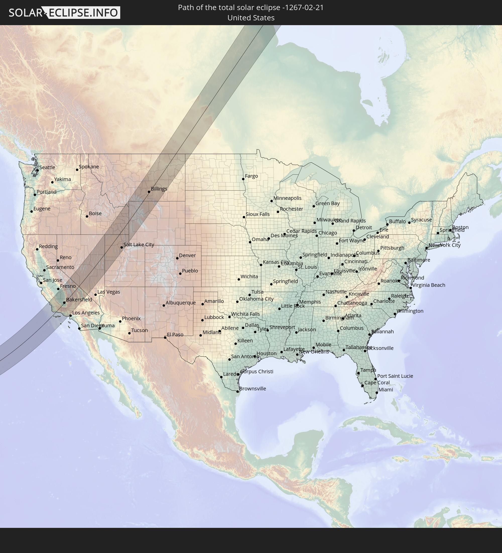 United States
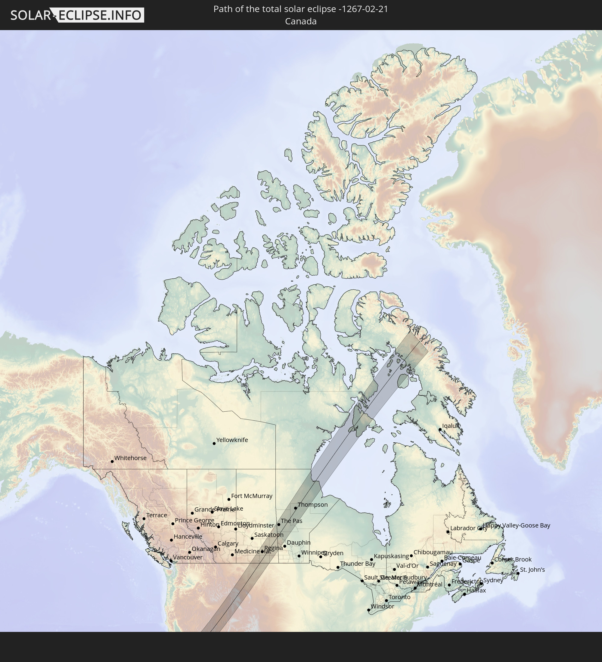 Canada
In den folgenden Ländern ist die Sonnenfinsternis partiell zu sehen


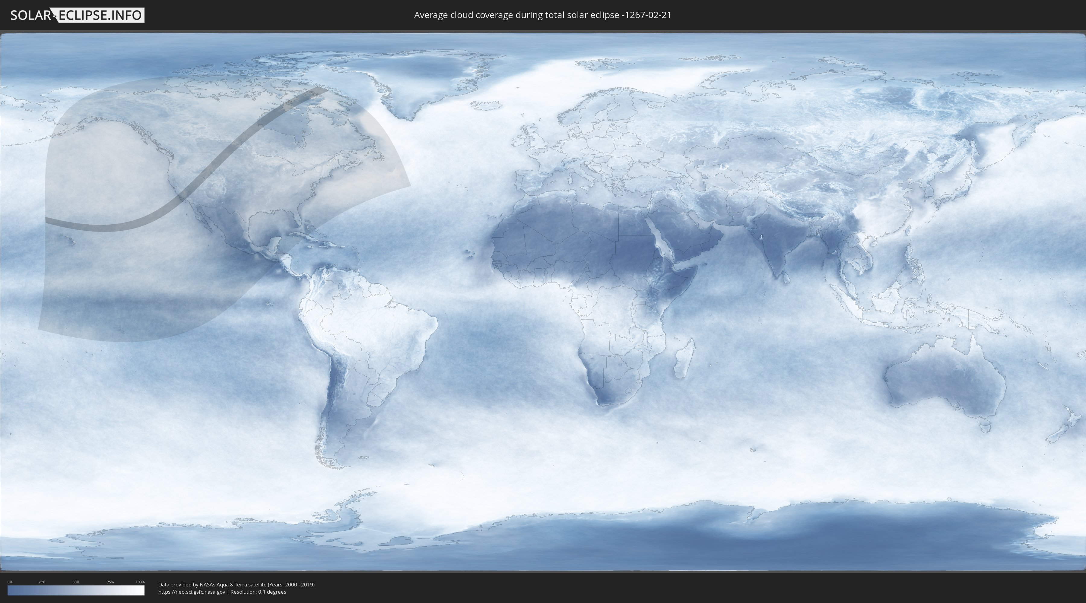
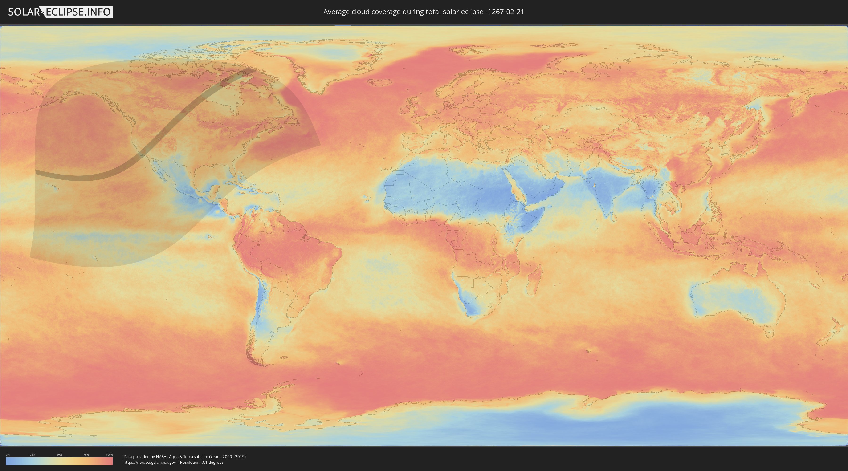
How will be the weather during the total solar eclipse on 02/21/-1267?
Where is the best place to see the total solar eclipse of 02/21/-1267?
The following maps show the average cloud coverage for the day of the total solar eclipse.
With the help of these maps, it is possible to find the place along the eclipse path, which has the best
chance of a cloudless sky.
Nevertheless, you should consider local circumstances and inform about the weather of your chosen
observation site.
The data is provided by NASAs satellites
AQUA and TERRA.
The cloud maps are averaged over a period of 19 years (2000 - 2019).
Detailed country maps
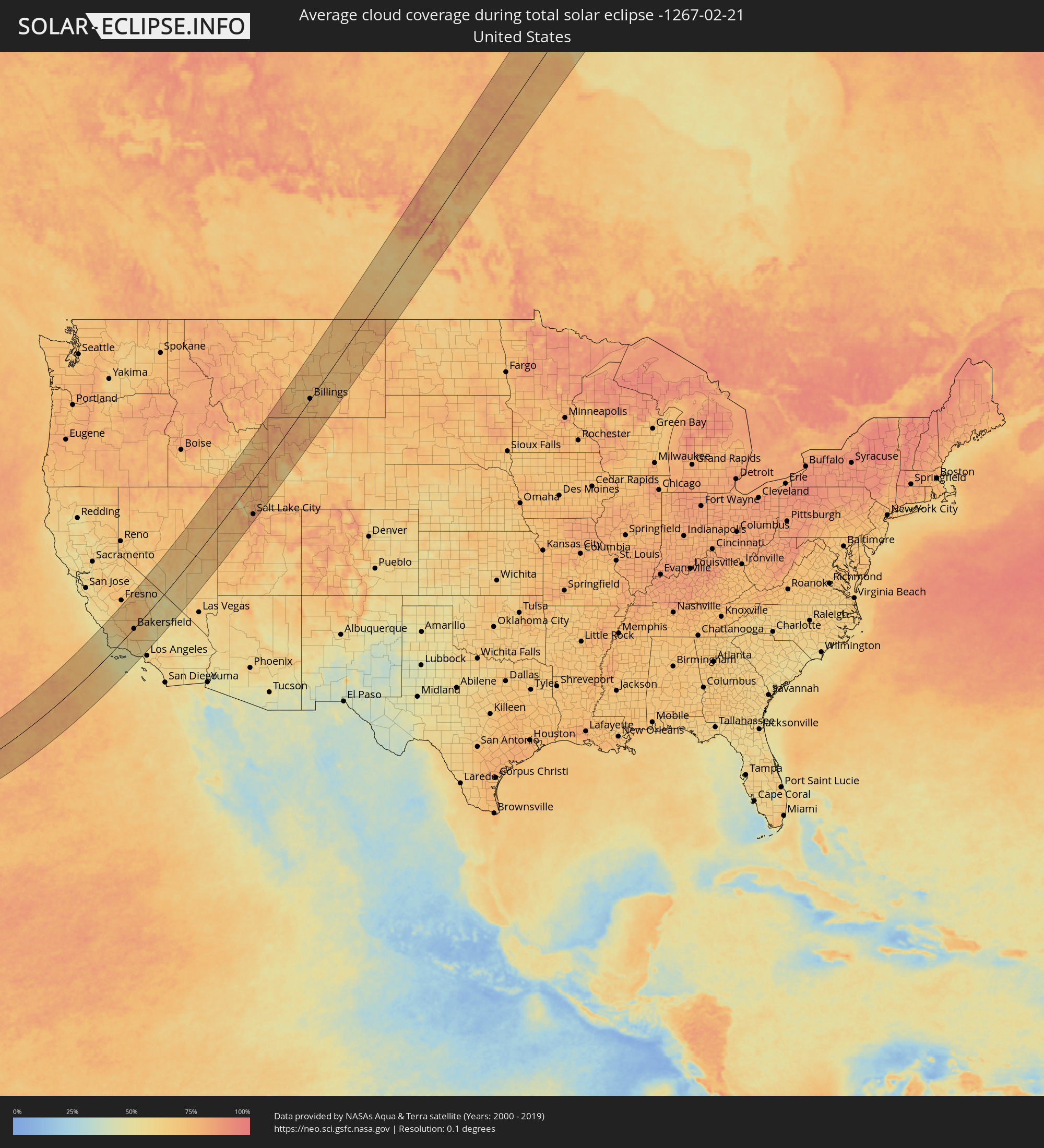 United States
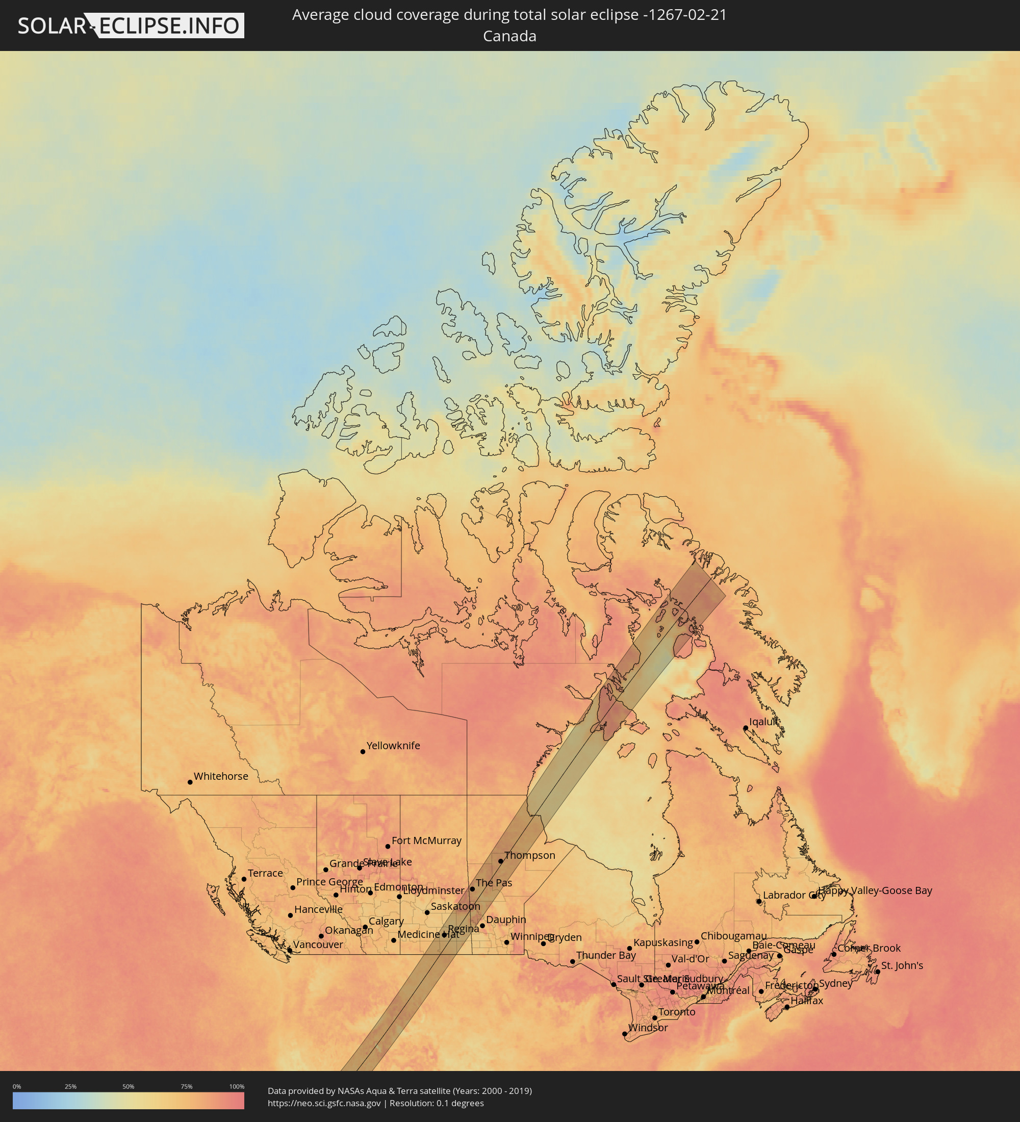 Canada
Cities inside the path of the eclipse
The following table shows all locations with a population of more than 5,000 inside the eclipse path. Cities which have more than 100,000 inhabitants are marked bold. A click at the locations opens a detailed map.
| City | Type | Eclipse duration | Local time of max. eclipse | Distance to central line | Ø Cloud coverage |
 Morro Bay, California
|
total | - | 10:57:30 UTC-08:00 | 120 km | 53% |
|
Los Osos, California
|
total | - | 10:57:28 UTC-08:00 | 115 km | 52% |
|
Templeton, California
|
total | - | 10:58:01 UTC-08:00 | 124 km | 60% |
|
Paso Robles, California
|
total | - | 10:58:10 UTC-08:00 | 129 km | 62% |
|
Atascadero, California
|
total | - | 10:58:00 UTC-08:00 | 117 km | 60% |
|
San Luis Obispo, California
|
total | - | 10:57:44 UTC-08:00 | 101 km | 56% |
|
Pismo Beach, California
|
total | - | 10:57:34 UTC-08:00 | 89 km | 53% |
|
Grover Beach, California
|
total | - | 10:57:34 UTC-08:00 | 86 km | 53% |
|
Arroyo Grande, California
|
total | - | 10:57:37 UTC-08:00 | 84 km | 53% |
|
Nipomo, California
|
total | - | 10:57:43 UTC-08:00 | 71 km | 58% |
|
Lompoc, California
|
total | - | 10:57:11 UTC-08:00 | 39 km | 54% |
|
Santa Maria, California
|
total | - | 10:57:40 UTC-08:00 | 61 km | 58% |
|
Avenal, California
|
total | - | 10:59:41 UTC-08:00 | 120 km | 68% |
|
Santa Barbara, California
|
total | - | 10:58:14 UTC-08:00 | 29 km | 48% |
|
Hanford, California
|
total | - | 11:00:59 UTC-08:00 | 111 km | 69% |
|
Montecito, California
|
total | - | 10:58:23 UTC-08:00 | 32 km | 47% |
|
Corcoran, California
|
total | - | 11:00:49 UTC-08:00 | 88 km | 67% |
|
Sanger, California
|
total | - | 11:01:40 UTC-08:00 | 133 km | 70% |
|
Kingsburg, California
|
total | - | 11:01:24 UTC-08:00 | 119 km | 69% |
|
Parlier, California
|
total | - | 11:01:35 UTC-08:00 | 124 km | 69% |
|
Carpinteria, California
|
total | - | 10:58:32 UTC-08:00 | 42 km | 49% |
|
Taft, California
|
total | - | 10:59:41 UTC-08:00 | 10 km | 67% |
|
Reedley, California
|
total | - | 11:01:42 UTC-08:00 | 118 km | 69% |
|
Wasco, California
|
total | - | 11:00:31 UTC-08:00 | 36 km | 70% |
|
Orange Cove, California
|
total | - | 11:01:59 UTC-08:00 | 110 km | 70% |
|
Visalia, California
|
total | - | 11:01:37 UTC-08:00 | 87 km | 68% |
|
Orosi, California
|
total | - | 11:01:55 UTC-08:00 | 103 km | 70% |
|
Earlimart, California
|
total | - | 11:01:03 UTC-08:00 | 53 km | 74% |
|
Shafter, California
|
total | - | 11:00:31 UTC-08:00 | 25 km | 73% |
|
Delano, California
|
total | - | 11:00:56 UTC-08:00 | 43 km | 72% |
|
McFarland, California
|
total | - | 11:00:50 UTC-08:00 | 35 km | 71% |
|
Farmersville, California
|
total | - | 11:01:43 UTC-08:00 | 79 km | 69% |
|
Oxnard, California
|
total | - | 10:58:52 UTC-08:00 | 80 km | 51% |
|
Rosedale, California
|
total | - | 11:00:35 UTC-08:00 | 7 km | 73% |
|
Exeter, California
|
total | - | 11:01:50 UTC-08:00 | 75 km | 73% |
|
Lindsay, California
|
total | - | 11:01:48 UTC-08:00 | 64 km | 70% |
|
Santa Paula, California
|
total | - | 10:59:18 UTC-08:00 | 76 km | 57% |
|
Bakersfield, California
|
total | - | 11:00:48 UTC-08:00 | 2 km | 72% |
|
Porterville, California
|
total | - | 11:01:45 UTC-08:00 | 49 km | 74% |
|
Fillmore, California
|
total | - | 10:59:37 UTC-08:00 | 82 km | 59% |
|
Lamont, California
|
total | - | 11:00:49 UTC-08:00 | 17 km | 68% |
|
Thousand Oaks, California
|
total | - | 10:59:27 UTC-08:00 | 105 km | 54% |
|
Arvin, California
|
total | - | 11:00:55 UTC-08:00 | 27 km | 68% |
|
Westlake Village, California
|
total | - | 10:59:28 UTC-08:00 | 109 km | 52% |
|
Malibu, California
|
total | - | 10:59:21 UTC-08:00 | 120 km | 48% |
|
Agoura Hills, California
|
total | - | 10:59:31 UTC-08:00 | 112 km | 52% |
|
Oak Park, California
|
total | - | 10:59:36 UTC-08:00 | 109 km | 54% |
|
Agoura, California
|
total | - | 10:59:35 UTC-08:00 | 114 km | 53% |
|
Malibu Beach, California
|
total | - | 10:59:31 UTC-08:00 | 126 km | 48% |
|
West Hills, California
|
total | - | 10:59:50 UTC-08:00 | 116 km | 56% |
|
Castaic, California
|
total | - | 11:00:17 UTC-08:00 | 95 km | 57% |
|
Topanga, California
|
total | - | 10:59:46 UTC-08:00 | 127 km | 54% |
|
Santa Clarita, California
|
total | - | 11:00:17 UTC-08:00 | 108 km | 57% |
|
Golden Hills, California
|
total | - | 11:01:25 UTC-08:00 | 55 km | 70% |
|
Tehachapi, California
|
total | - | 11:01:29 UTC-08:00 | 58 km | 69% |
|
Van Nuys, California
|
total | - | 11:00:10 UTC-08:00 | 130 km | 57% |
|
Quartz Hill, California
|
total | - | 11:01:14 UTC-08:00 | 110 km | 59% |
|
Rosamond, California
|
total | - | 11:01:38 UTC-08:00 | 98 km | 56% |
|
Lancaster, California
|
total | - | 11:01:27 UTC-08:00 | 112 km | 57% |
|
Vincent, California
|
total | - | 11:01:13 UTC-08:00 | 128 km | 59% |
|
California City, California
|
total | - | 11:02:18 UTC-08:00 | 90 km | 54% |
|
Ridgecrest, California
|
total | - | 11:03:32 UTC-08:00 | 74 km | 54% |
|
Chubbuck, Idaho
|
total | - | 12:20:41 UTC-07:00 | 77 km | 82% |
|
Grantsville, Utah
|
total | - | 12:18:23 UTC-07:00 | 76 km | 76% |
|
Pocatello, Idaho
|
total | - | 12:20:40 UTC-07:00 | 73 km | 84% |
|
Blackfoot, Idaho
|
total | - | 12:21:08 UTC-07:00 | 87 km | 78% |
|
Tooele, Utah
|
total | - | 12:18:35 UTC-07:00 | 92 km | 83% |
|
Tremonton, Utah
|
total | - | 12:19:59 UTC-07:00 | 22 km | 73% |
|
Magna, Utah
|
total | - | 12:19:05 UTC-07:00 | 93 km | 81% |
|
West Point, Utah
|
total | - | 12:19:31 UTC-07:00 | 67 km | 74% |
|
West Haven, Utah
|
total | - | 12:19:40 UTC-07:00 | 63 km | 77% |
|
Clinton, Utah
|
total | - | 12:19:36 UTC-07:00 | 68 km | 74% |
|
Idaho Falls, Idaho
|
total | - | 12:21:52 UTC-07:00 | 84 km | 75% |
|
Oquirrh, Utah
|
total | - | 12:19:07 UTC-07:00 | 103 km | 82% |
|
Brigham City, Utah
|
total | - | 12:20:02 UTC-07:00 | 45 km | 81% |
|
Riverdale, Utah
|
total | - | 12:19:43 UTC-07:00 | 68 km | 83% |
|
Pleasant View, Utah
|
total | - | 12:19:52 UTC-07:00 | 60 km | 82% |
|
Washington Terrace, Utah
|
total | - | 12:19:45 UTC-07:00 | 70 km | 83% |
|
Ogden, Utah
|
total | - | 12:19:48 UTC-07:00 | 67 km | 83% |
|
South Ogden, Utah
|
total | - | 12:19:47 UTC-07:00 | 70 km | 83% |
|
Layton, Utah
|
total | - | 12:19:39 UTC-07:00 | 78 km | 82% |
|
Ammon, Idaho
|
total | - | 12:21:59 UTC-07:00 | 80 km | 75% |
|
North Ogden, Utah
|
total | - | 12:19:55 UTC-07:00 | 63 km | 82% |
|
West Jordan, Utah
|
total | - | 12:19:14 UTC-07:00 | 111 km | 82% |
|
North Salt Lake, Utah
|
total | - | 12:19:32 UTC-07:00 | 97 km | 83% |
|
Woods Cross, Utah
|
total | - | 12:19:35 UTC-07:00 | 96 km | 84% |
|
Salt Lake City, Utah
|
total | - | 12:19:28 UTC-07:00 | 104 km | 83% |
|
Farmington, Utah
|
total | - | 12:19:42 UTC-07:00 | 89 km | 82% |
|
Centerville, Utah
|
total | - | 12:19:40 UTC-07:00 | 95 km | 84% |
|
Hyrum, Utah
|
total | - | 12:20:25 UTC-07:00 | 48 km | 76% |
|
Logan, Utah
|
total | - | 12:20:32 UTC-07:00 | 42 km | 81% |
|
Smithfield, Utah
|
total | - | 12:20:38 UTC-07:00 | 36 km | 80% |
|
Little Cottonwood Creek Valley, Utah
|
total | - | 12:19:25 UTC-07:00 | 119 km | 84% |
|
Canyon Rim, Utah
|
total | - | 12:19:32 UTC-07:00 | 112 km | 83% |
|
East Millcreek, Utah
|
total | - | 12:19:32 UTC-07:00 | 113 km | 83% |
|
North Logan, Utah
|
total | - | 12:20:37 UTC-07:00 | 42 km | 80% |
|
Rexburg, Idaho
|
total | - | 12:22:34 UTC-07:00 | 91 km | 71% |
|
Jackson, Wyoming
|
total | - | 12:23:50 UTC-07:00 | 1 km | 77% |
|
Cody, Wyoming
|
total | - | 12:27:16 UTC-07:00 | 42 km | 74% |
|
Billings, Montana
|
total | - | 12:29:02 UTC-07:00 | 2 km | 74% |
 Moose Jaw, Saskatchewan
|
total | - | 12:37:10 UTC-06:58 | 107 km | 68% |
|
Regina, Saskatchewan
|
total | - | 12:38:21 UTC-06:58 | 55 km | 73% |
|
Weyburn, Saskatchewan
|
total | - | 12:38:58 UTC-06:58 | 39 km | 67% |
|
Yorkton, Saskatchewan
|
total | - | 12:41:16 UTC-06:58 | 22 km | 65% |
|
The Pas, Manitoba
|
total | - | 13:41:59 UTC-06:00 | 71 km | 76% |
|
Thompson, Manitoba
|
total | - | 13:45:49 UTC-06:00 | 8 km | 78% |