Total solar eclipse of 05/22/-1468
| Day of week: | Tuesday |
| Maximum duration of eclipse: | 03m37s |
| Maximum width of eclipse path: | 253 km |
| Saros cycle: | 14 |
| Coverage: | 100% |
| Magnitude: | 1.0533 |
| Gamma: | 0.7155 |
Wo kann man die Sonnenfinsternis vom 05/22/-1468 sehen?
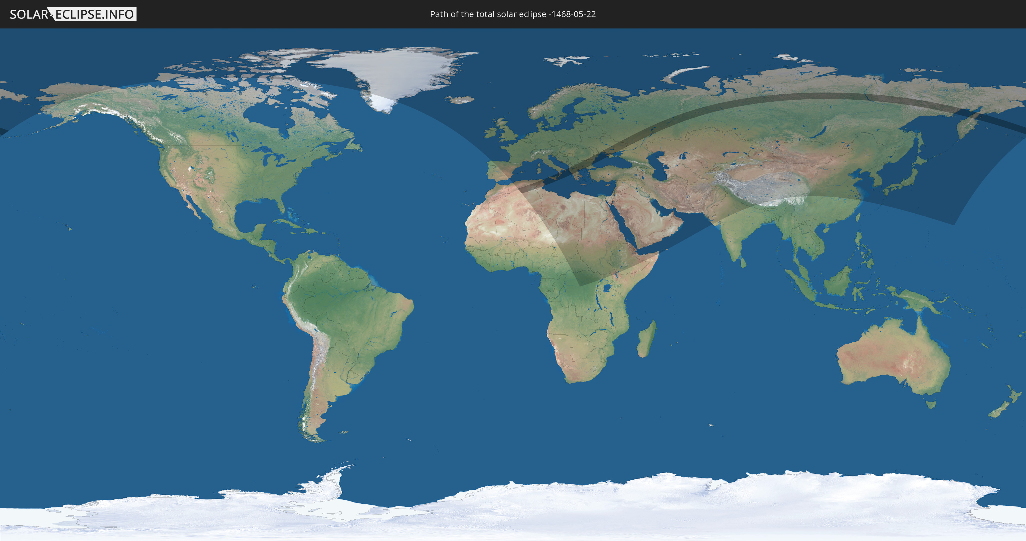
Die Sonnenfinsternis am 05/22/-1468 kann man in 100 Ländern als partielle Sonnenfinsternis beobachten.
Der Finsternispfad verläuft durch 12 Länder. Nur in diesen Ländern ist sie als total Sonnenfinsternis zu sehen.
In den folgenden Ländern ist die Sonnenfinsternis total zu sehen
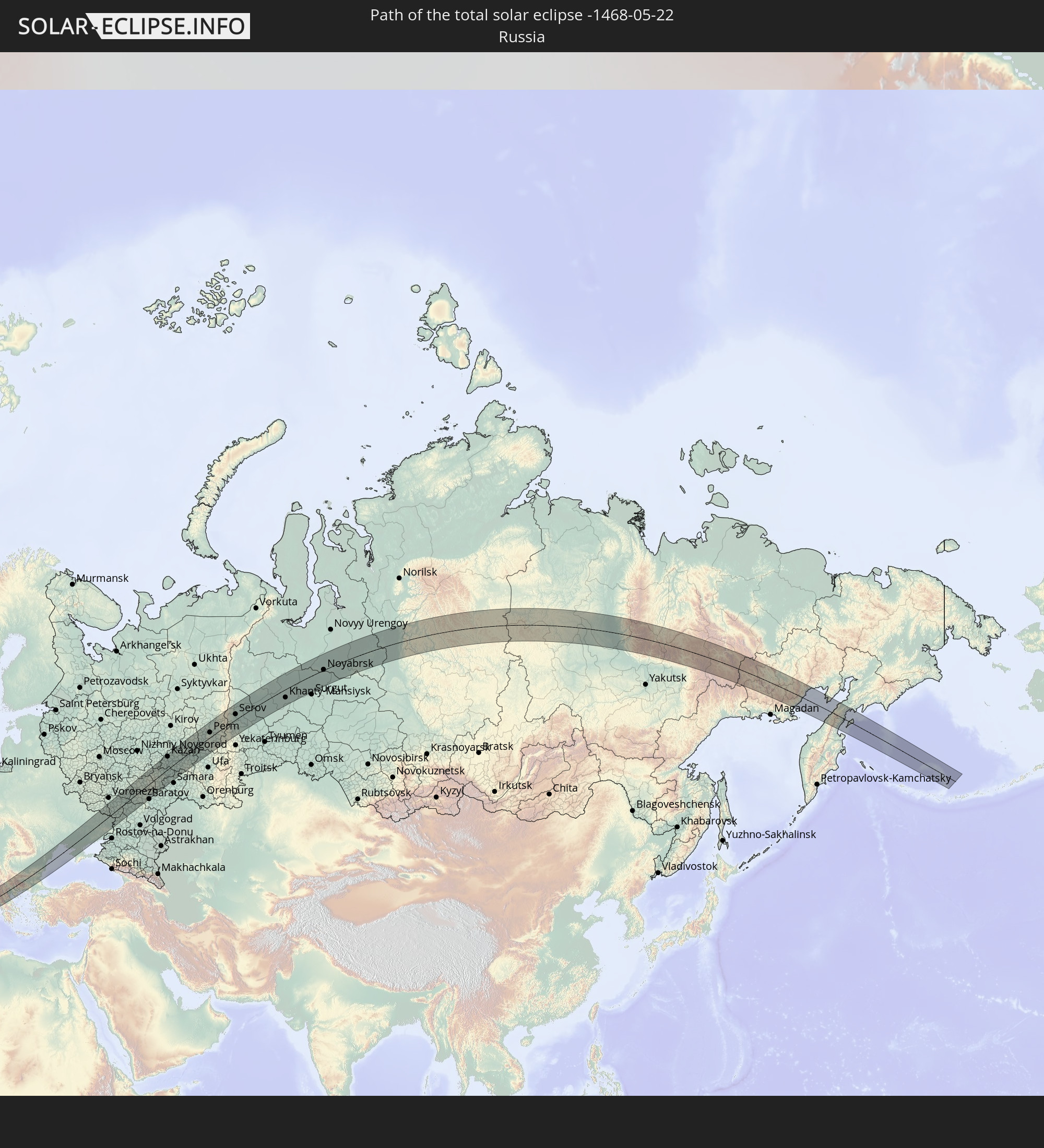 Russia
 Algeria
 Italy
Italy
 Tunisia
 Serbia
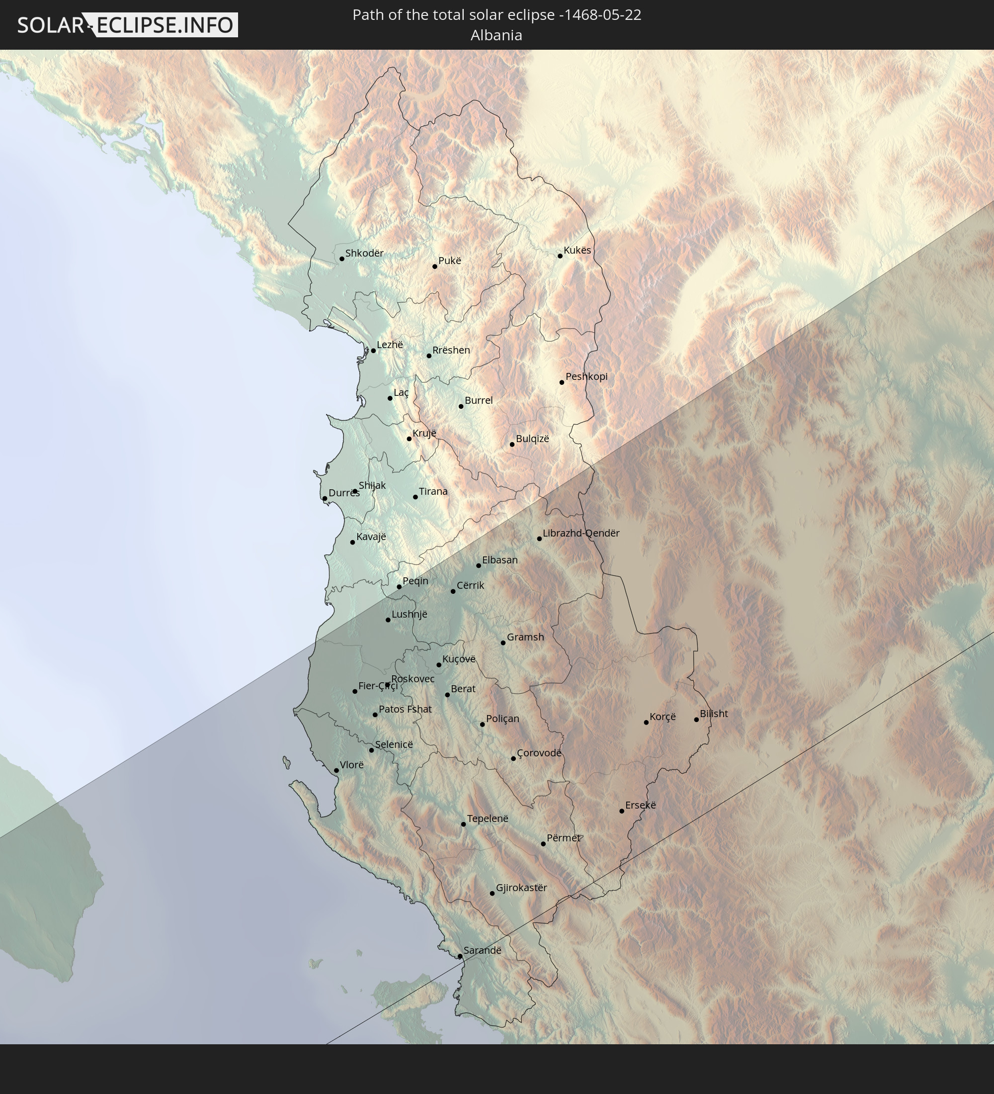 Albania
 Greece
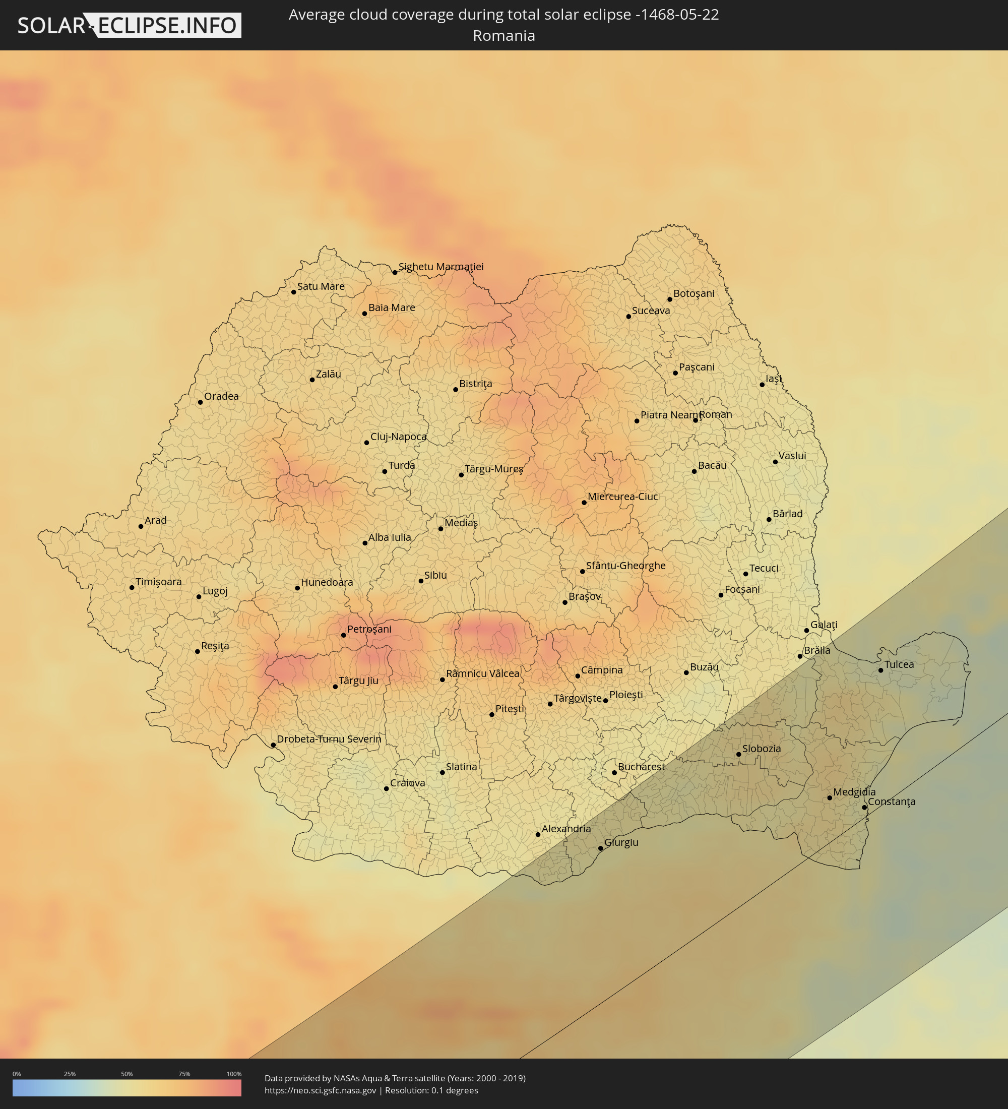
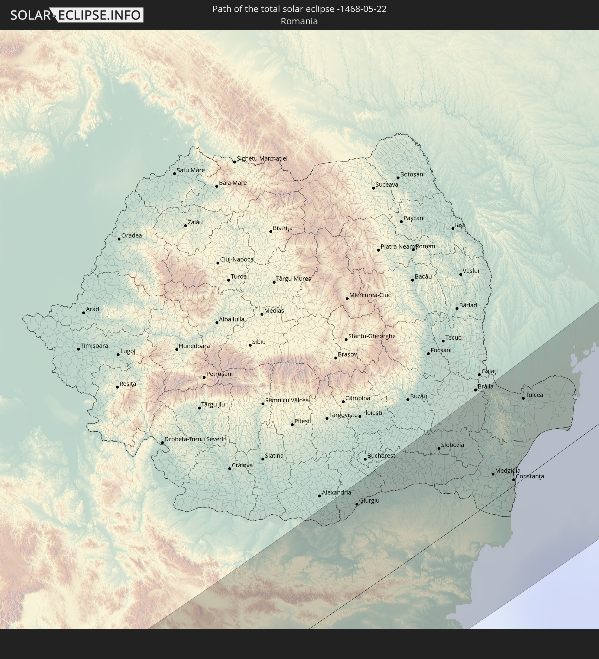 Romania
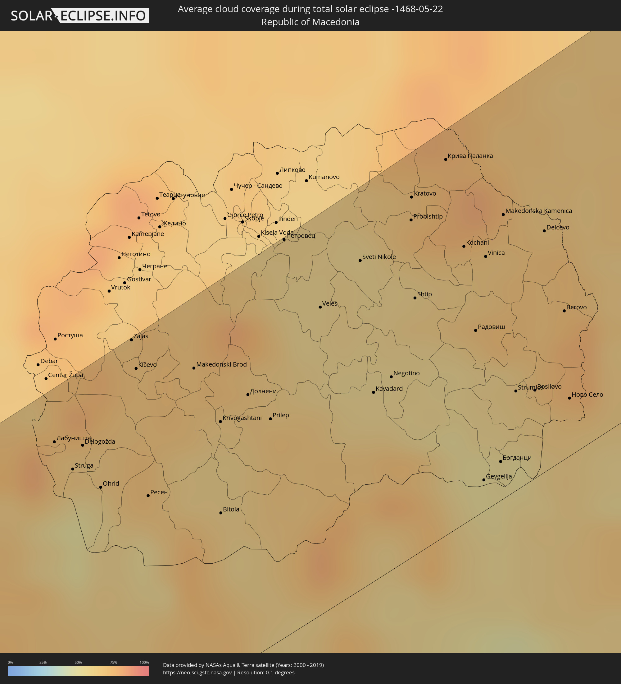
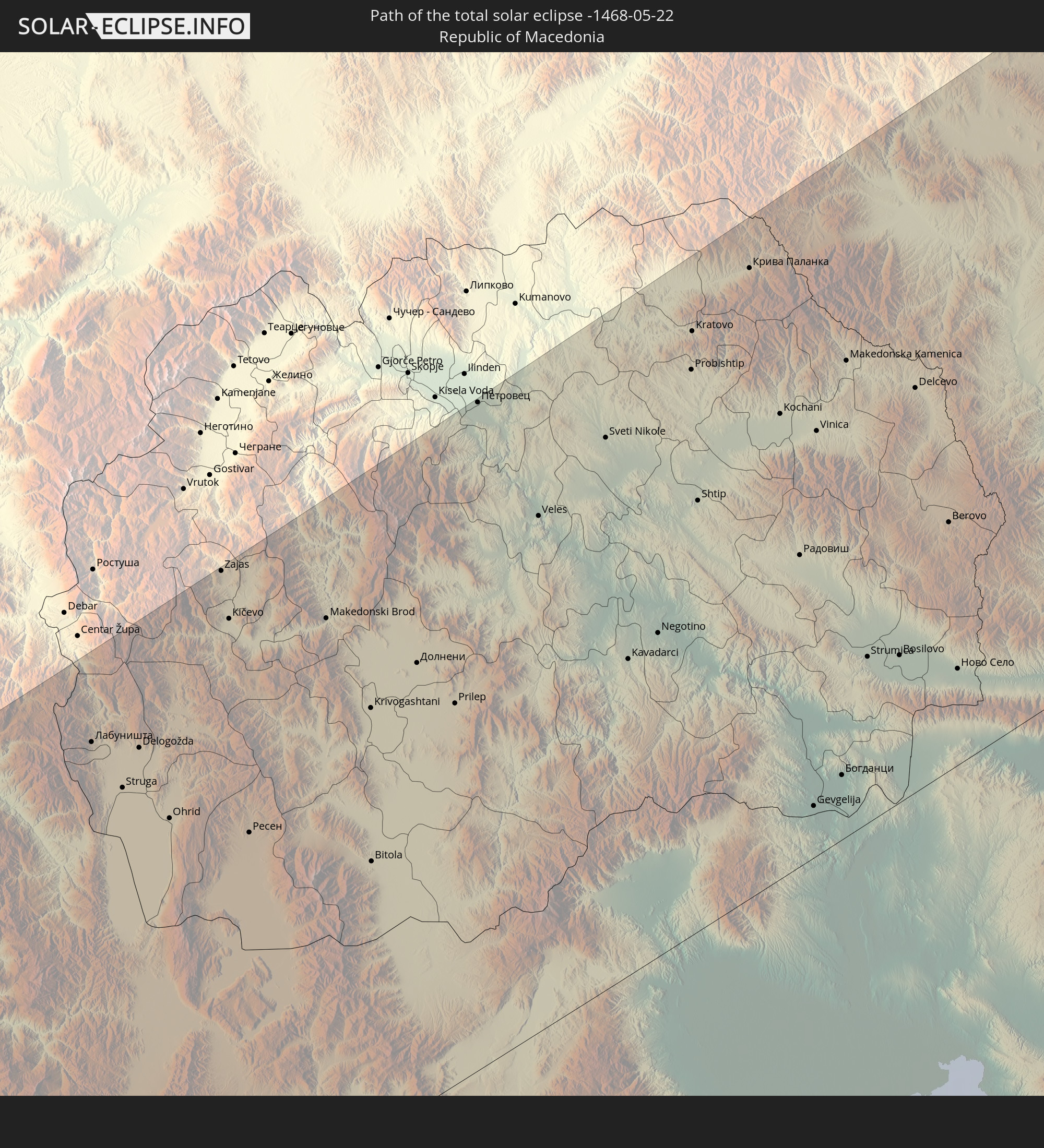 Republic of Macedonia
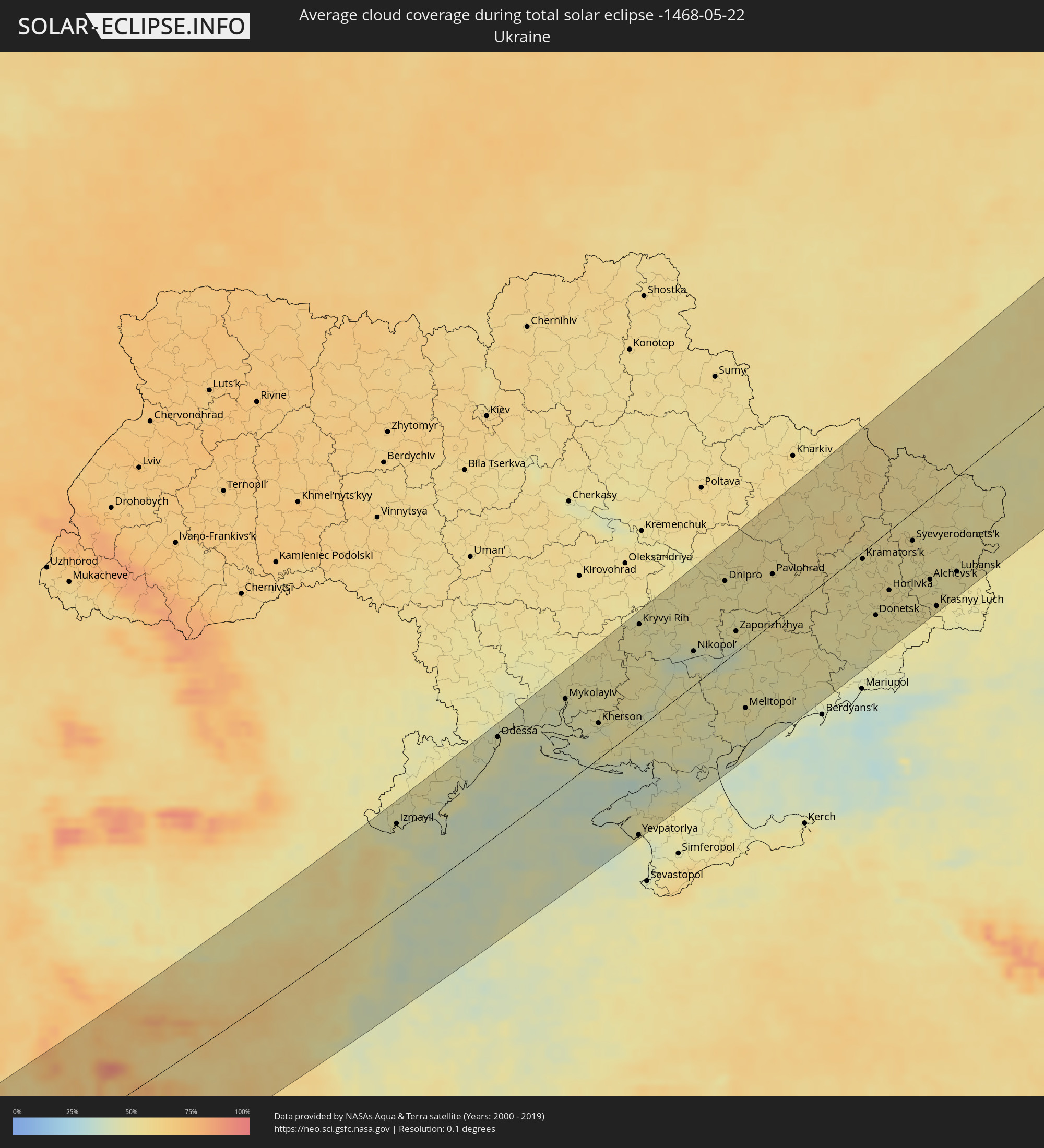
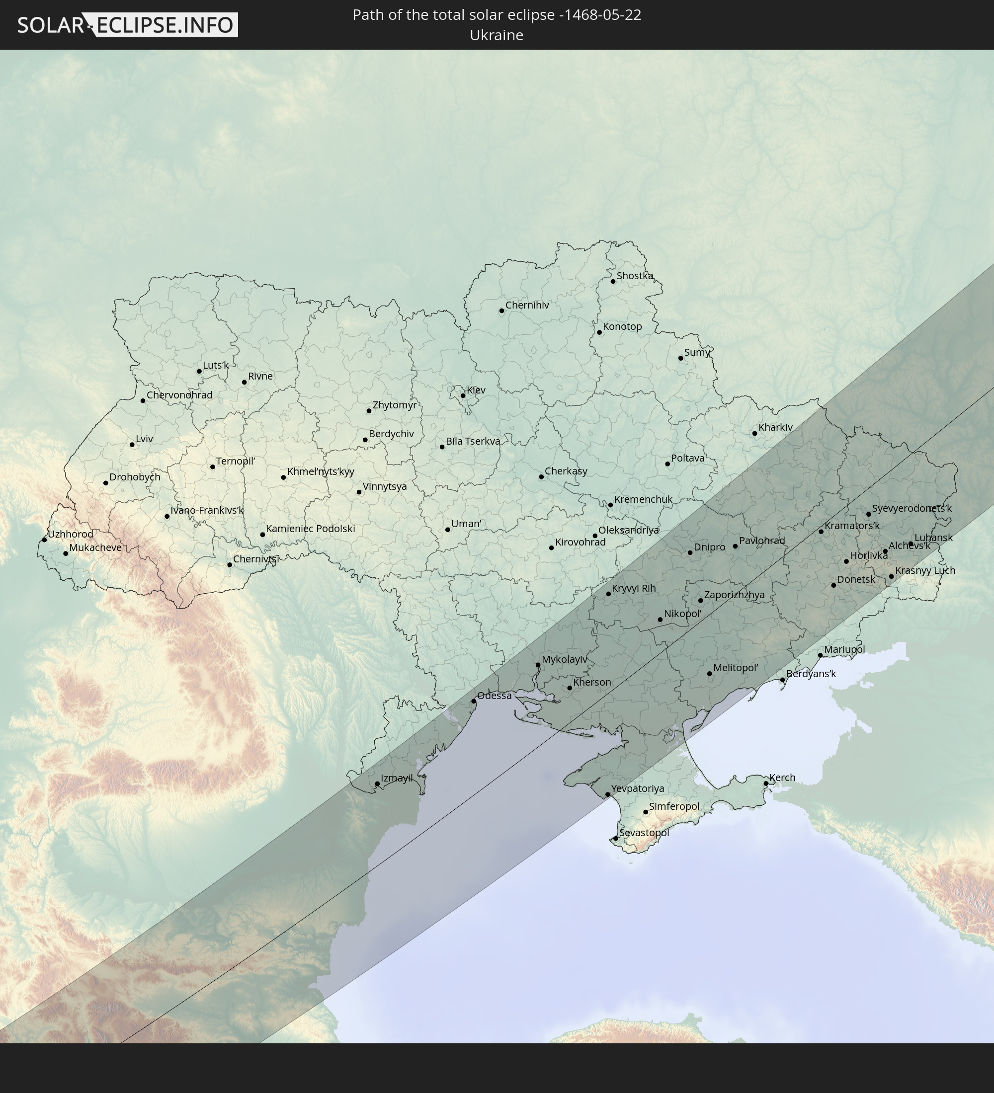 Ukraine
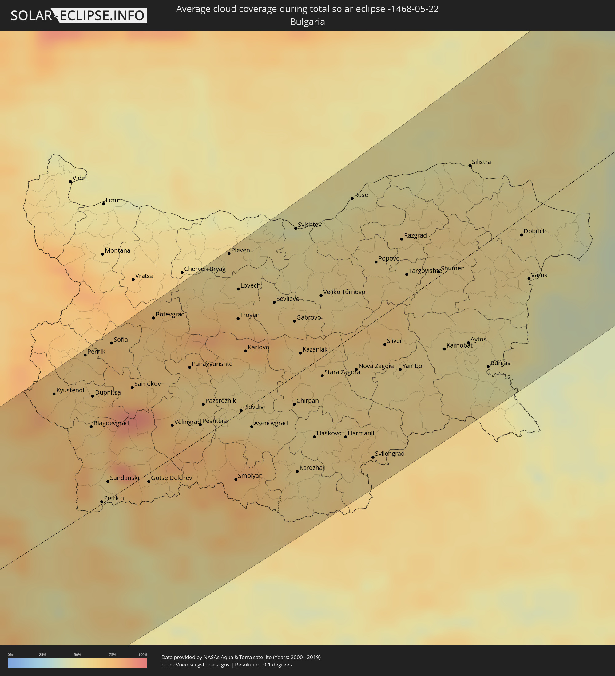
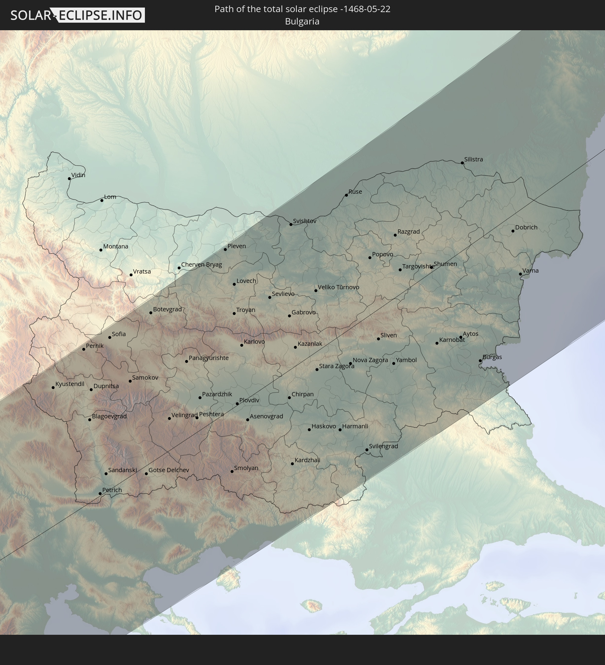 Bulgaria
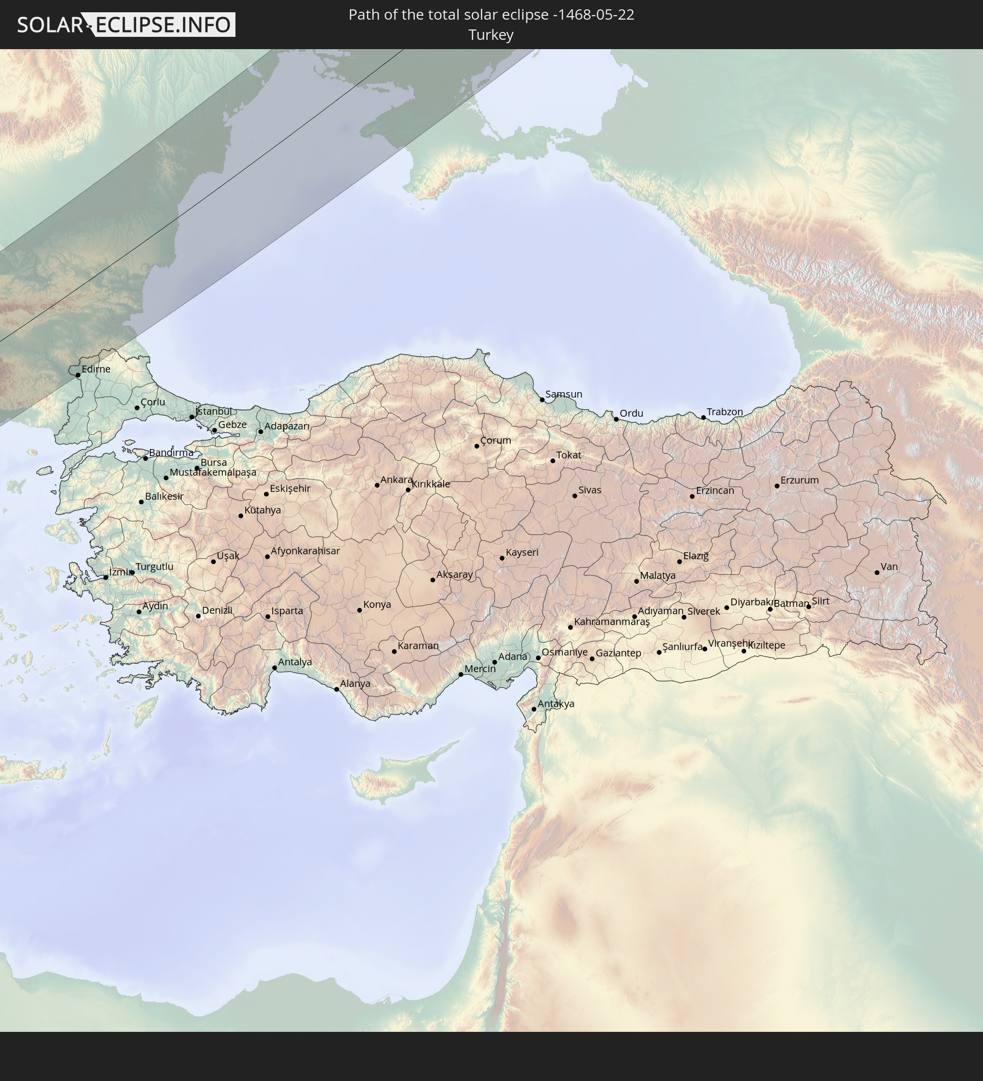 Turkey
In den folgenden Ländern ist die Sonnenfinsternis partiell zu sehen
 Russia
 United States
 Canada
 Greenland
 Iceland
 Spain
Spain
 Republic of Ireland
 Svalbard and Jan Mayen
 Algeria
 United Kingdom
 Faroe Islands
 France
 Isle of Man
 Guernsey
 Jersey
 Niger
Niger
 Andorra
 Belgium
 Netherlands
 Norway
 Luxembourg
 Germany
 Switzerland
 Italy
Italy
 Monaco
 Tunisia
 Denmark
 Libya
Libya
 Liechtenstein
 Austria
 Sweden
 Czechia
 Democratic Republic of the Congo
 San Marino
 Vatican City
 Slovenia
 Chad
Chad
 Croatia
 Poland
 Malta
Malta
 Central African Republic
 Bosnia and Herzegovina
 Hungary
 Slovakia
 Montenegro
 Serbia
 Albania
 Åland Islands
 Greece
 Romania
 Republic of Macedonia
 Finland
 Lithuania
 Latvia
 Estonia
 Sudan
Sudan
 Ukraine
 Bulgaria
 Belarus
 Egypt
Egypt
 Turkey
 Moldova
 Uganda
 Cyprus
 Ethiopia
 Kenya
Kenya
 State of Palestine
 Israel
 Saudi Arabia
 Jordan
 Lebanon
 Syria
Syria
 Eritrea
 Iraq
Iraq
 Georgia
 Somalia
 Djibouti
 Yemen
Yemen
 Armenia
 Iran
Iran
 Azerbaijan
 Kazakhstan
 Kuwait
 Bahrain
 Qatar
Qatar
 United Arab Emirates
 Oman
Oman
 Turkmenistan
 Uzbekistan
 Afghanistan
 Pakistan
 Tajikistan
 India
India
 Kyrgyzstan
 China
China
 Nepal
Nepal
 Mongolia
 Japan
Japan
 North Korea
 South Korea
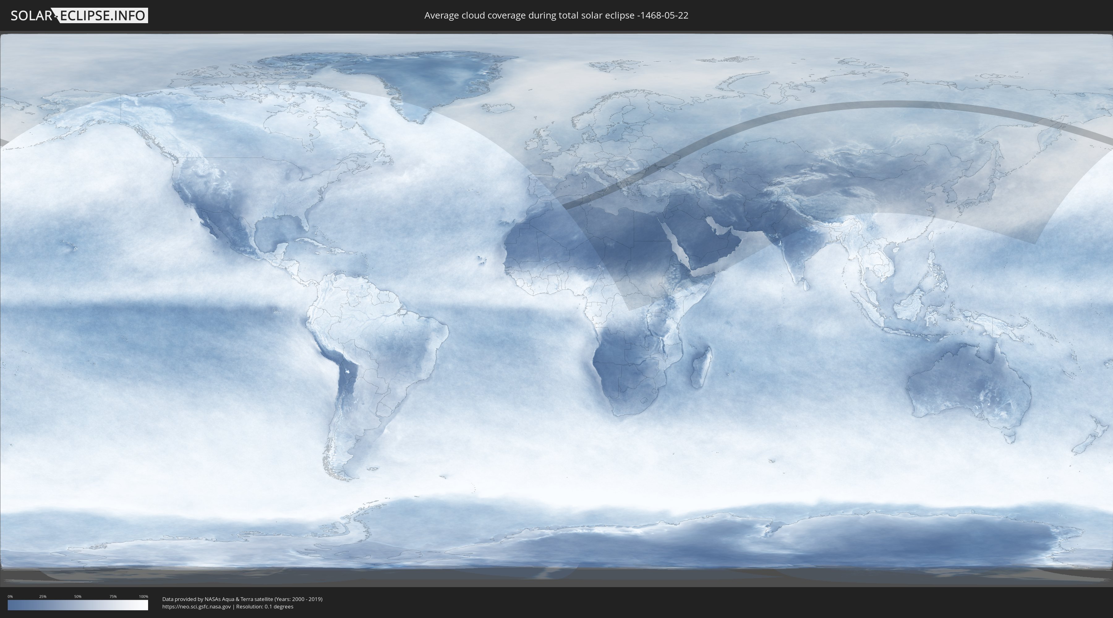
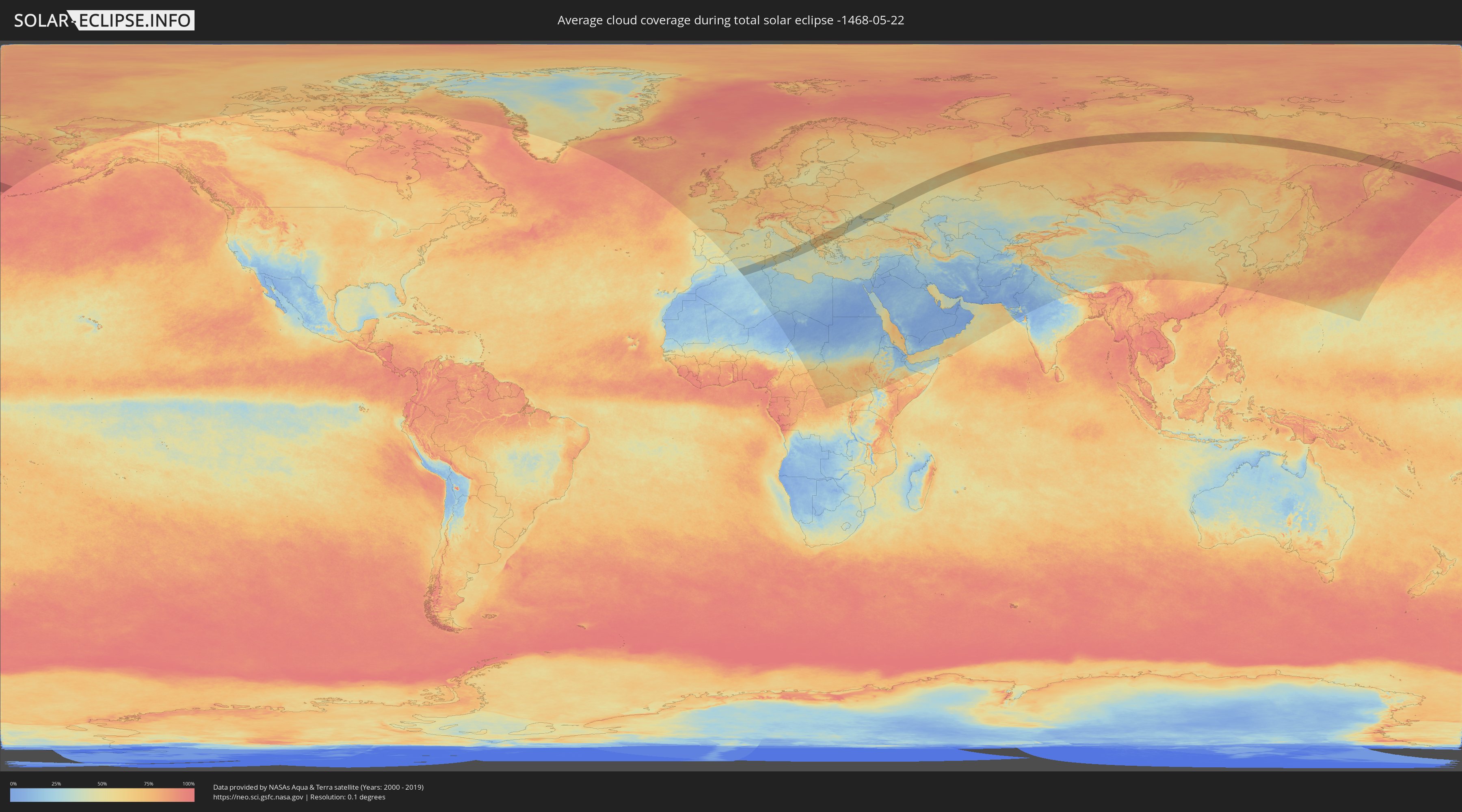
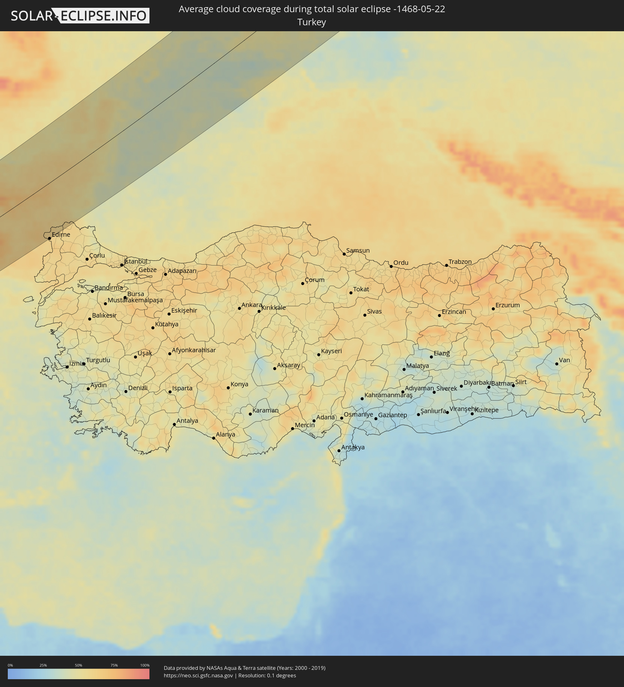
How will be the weather during the total solar eclipse on 05/22/-1468?
Where is the best place to see the total solar eclipse of 05/22/-1468?
The following maps show the average cloud coverage for the day of the total solar eclipse.
With the help of these maps, it is possible to find the place along the eclipse path, which has the best
chance of a cloudless sky.
Nevertheless, you should consider local circumstances and inform about the weather of your chosen
observation site.
The data is provided by NASAs satellites
AQUA and TERRA.
The cloud maps are averaged over a period of 19 years (2000 - 2019).
Detailed country maps
 Russia
 Algeria
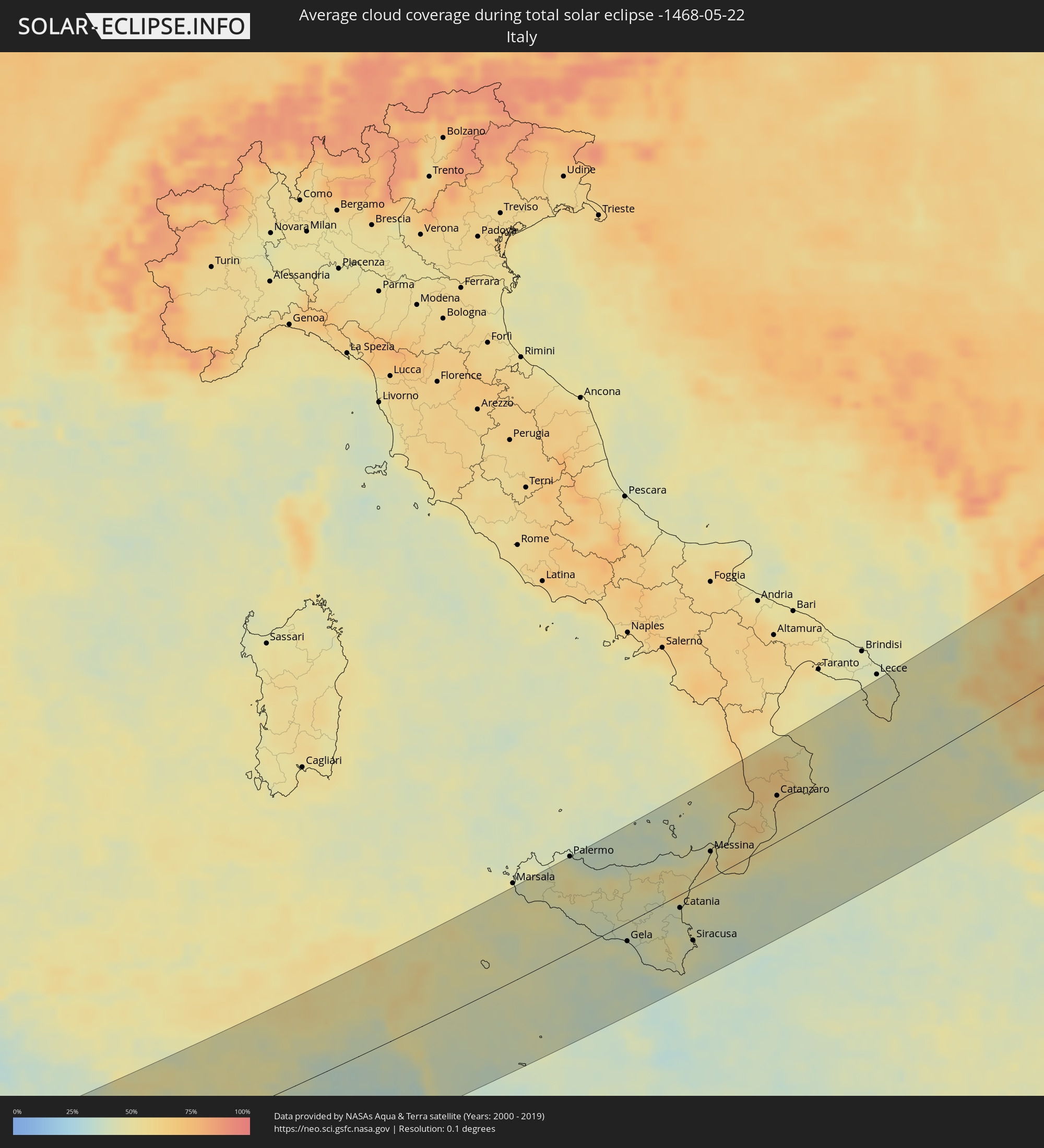 Italy
Italy
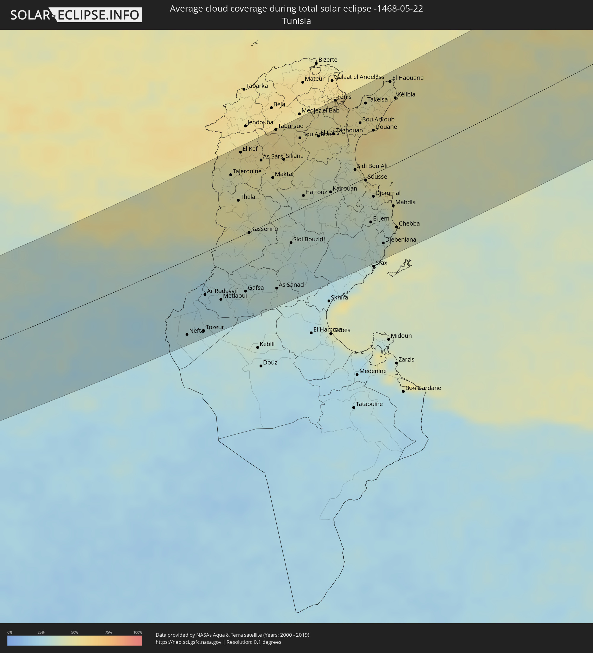 Tunisia
 Serbia
 Albania
 Greece
 Romania
 Republic of Macedonia
 Ukraine
 Bulgaria
 Turkey
Cities inside the path of the eclipse
The following table shows all locations with a population of more than 5,000 inside the eclipse path. Cities which have more than 100,000 inhabitants are marked bold. A click at the locations opens a detailed map.
| City | Type | Eclipse duration | Local time of max. eclipse | Distance to central line | Ø Cloud coverage |
|
Laghouat, Laghouat
|
total | - | 05:04:55 UTC+00:09 | 73 km | 31% |
|
Messaad, Djelfa
|
total | - | 05:05:08 UTC+00:09 | 88 km | 33% |
|
Ghardaïa, Ghardaia
|
total | - | 05:03:02 UTC+00:09 | 91 km | 27% |
|
Berriane, Ghardaia
|
total | - | 05:03:24 UTC+00:09 | 60 km | 27% |
|
Sidi Khaled, Biskra
|
total | - | 05:04:56 UTC+00:09 | 64 km | 31% |
|
Tolga, Biskra
|
total | - | 05:05:14 UTC+00:09 | 83 km | 34% |
|
Biskra, Biskra
|
total | - | 05:05:18 UTC+00:09 | 81 km | 31% |
|
Sidi Okba, Biskra
|
total | - | 05:05:07 UTC+00:09 | 66 km | 32% |
|
Djamaa, Ouargla
|
total | - | 05:03:32 UTC+00:09 | 68 km | 27% |
|
Sidi Amrane, Ouargla
|
total | - | 05:03:29 UTC+00:09 | 72 km | 27% |
|
Megarine, Ouargla
|
total | - | 05:03:05 UTC+00:09 | 103 km | 30% |
|
Arris, Batna
|
total | - | 05:05:39 UTC+00:09 | 103 km | 47% |
|
Reguiba, El Oued
|
total | - | 05:03:22 UTC+00:09 | 87 km | 27% |
|
Debila, El Oued
|
total | - | 05:03:14 UTC+00:09 | 100 km | 25% |
|
Khenchela, Khenchela
|
total | - | 05:05:39 UTC+00:09 | 90 km | 50% |
|
Meskiana, Oum el Bouaghi
|
total | - | 05:05:47 UTC+00:09 | 90 km | 49% |
|
Cheria, Tébessa
|
total | - | 05:05:17 UTC+00:09 | 50 km | 47% |
|
El Aouinet, Oum el Bouaghi
|
total | - | 05:06:02 UTC+00:09 | 106 km | 45% |
|
Bir el Ater, Tébessa
|
total | - | 05:04:31 UTC+00:09 | 15 km | 29% |
|
Tébessa, Tébessa
|
total | - | 05:05:22 UTC+00:09 | 50 km | 50% |
|
Tozeur, Tawzar
|
total | - | 05:03:25 UTC+00:09 | 103 km | 28% |
|
Ar Rudayyif, Gafsa
|
total | - | 05:04:01 UTC+00:09 | 55 km | 26% |
|
Metlaoui, Gafsa
|
total | - | 05:03:52 UTC+00:09 | 71 km | 27% |
|
El Kef, Kef
|
total | - | 05:06:16 UTC+00:09 | 108 km | 51% |
|
Gafsa, Gafsa
|
total | - | 05:03:54 UTC+00:09 | 74 km | 31% |
|
Kasserine, Al Qaşrayn
|
total | - | 05:04:53 UTC+00:09 | 17 km | 43% |
|
Siliana, Silyānah
|
total | - | 05:05:59 UTC+00:09 | 75 km | 50% |
|
Sidi Bouzid, Sīdī Bū Zayd
|
total | - | 05:04:33 UTC+00:09 | 43 km | 32% |
|
Kairouan, Al Qayrawān
|
total | - | 05:05:17 UTC+00:09 | 11 km | 39% |
|
La Mohammedia, Tūnis
|
total | - | 05:06:38 UTC+00:09 | 102 km | 53% |
|
Tunis, Tūnis
|
total | - | 05:06:50 UTC+00:09 | 117 km | 53% |
|
Al Marsá, Tūnis
|
total | - | 05:06:53 UTC+00:09 | 115 km | 58% |
|
Hammam-Lif, Tūnis
|
total | - | 05:06:41 UTC+00:09 | 100 km | 53% |
|
Sousse, Sūsah
|
total | - | 05:05:23 UTC+00:09 | 13 km | 41% |
|
Douane, Nābul
|
total | - | 05:06:13 UTC+00:09 | 55 km | 54% |
|
Djemmal, Al Munastīr
|
total | - | 05:05:05 UTC+00:09 | 31 km | 39% |
|
Monastir, Al Munastīr
|
total | - | 05:05:17 UTC+00:09 | 29 km | 45% |
|
Korba, Nābul
|
total | - | 05:06:22 UTC+00:09 | 66 km | 57% |
|
Mahdia, Al Mahdīyah
|
total | - | 05:04:52 UTC+00:09 | 55 km | 48% |
|
Kélibia, Nābul
|
total | - | 05:06:42 UTC+00:09 | 81 km | 54% |
|
Mazara del Vallo, Sicily
|
total | - | 05:58:16 UTC+01:00 | 101 km | 47% |
|
Alcamo, Sicily
|
total | - | 05:58:41 UTC+01:00 | 119 km | 43% |
|
Sciacca, Sicily
|
total | - | 05:58:00 UTC+01:00 | 67 km | 48% |
|
Palermo, Sicily
|
total | - | 05:58:52 UTC+01:00 | 118 km | 48% |
|
Bagheria, Sicily
|
total | - | 05:58:46 UTC+01:00 | 106 km | 42% |
|
Licata, Sicily
|
total | - | 05:57:19 UTC+01:00 | 13 km | 45% |
|
Caltanissetta, Sicily
|
total | - | 05:57:52 UTC+01:00 | 32 km | 46% |
|
Gela, Sicily
|
total | - | 05:57:15 UTC+01:00 | 26 km | 43% |
|
Caltagirone, Sicily
|
total | - | 05:57:27 UTC+01:00 | 20 km | 43% |
|
Vittoria, Sicily
|
total | - | 05:57:02 UTC+01:00 | 52 km | 40% |
|
Ragusa, Sicily
|
total | - | 05:56:59 UTC+01:00 | 58 km | 42% |
|
Paternò, Sicily
|
total | - | 05:57:54 UTC+01:00 | 2 km | 43% |
|
Catania, Sicily
|
total | - | 05:57:46 UTC+01:00 | 16 km | 45% |
|
Acireale, Sicily
|
total | - | 05:57:56 UTC+01:00 | 9 km | 46% |
|
Siracusa, Sicily
|
total | - | 05:57:10 UTC+01:00 | 65 km | 45% |
|
Messina, Sicily
|
total | - | 05:58:46 UTC+01:00 | 32 km | 60% |
|
Cosenza, Calabria
|
total | - | 06:00:23 UTC+01:00 | 110 km | 60% |
|
Lamezia Terme, Calabria
|
total | - | 05:59:52 UTC+01:00 | 75 km | 63% |
|
Catanzaro, Calabria
|
total | - | 05:59:45 UTC+01:00 | 55 km | 57% |
|
Crotone, Calabria
|
total | - | 06:00:02 UTC+01:00 | 52 km | 51% |
|
Vlorë, Vlorë
|
total | - | 06:21:32 UTC+01:19 | 81 km | 46% |
|
Fier, Fier
|
total | - | 06:21:57 UTC+01:19 | 102 km | 48% |
|
Fier-Çifçi, Fier
|
total | - | 06:21:56 UTC+01:19 | 101 km | 48% |
|
Patos Fshat, Fier
|
total | - | 06:21:49 UTC+01:19 | 90 km | 54% |
|
Lushnjë, Fier
|
total | - | 06:22:18 UTC+01:19 | 117 km | 52% |
|
Ballsh, Fier
|
total | - | 06:21:45 UTC+01:19 | 83 km | 54% |
|
Kuçovë, Berat
|
total | - | 06:22:05 UTC+01:19 | 94 km | 54% |
|
Corfu, Ionian Islands
|
total | - | 06:35:46 UTC+01:34 | 19 km | 44% |
|
Berat, Berat
|
total | - | 06:21:56 UTC+01:19 | 83 km | 57% |
|
Cërrik, Elbasan
|
total | - | 06:22:27 UTC+01:19 | 114 km | 51% |
|
Sarandë, Vlorë
|
total | - | 06:20:38 UTC+01:19 | 2 km | 48% |
|
Tepelenë, Gjirokastër
|
total | - | 06:21:18 UTC+01:19 | 47 km | 61% |
|
Elbasan, Elbasan
|
total | - | 06:22:35 UTC+01:19 | 117 km | 55% |
|
Poliçan, Berat
|
total | - | 06:21:48 UTC+01:19 | 68 km | 61% |
|
Gjirokastër, Gjirokastër
|
total | - | 06:20:58 UTC+01:19 | 15 km | 63% |
|
Gramsh, Elbasan
|
total | - | 06:22:13 UTC+01:19 | 91 km | 60% |
|
Çorovodë, Berat
|
total | - | 06:21:38 UTC+01:19 | 52 km | 60% |
|
Librazhd-Qendër, Elbasan
|
total | - | 06:22:44 UTC+01:19 | 112 km | 61% |
|
Përmet, Gjirokastër
|
total | - | 06:21:13 UTC+01:19 | 21 km | 72% |
|
Лабуништа
|
total | - | 06:03:33 UTC+01:00 | 110 km | 69% |
|
Ersekë, Korçë
|
total | - | 06:21:24 UTC+01:19 | 27 km | 74% |
|
Préveza, Epirus
|
total | - | 06:34:47 UTC+01:34 | 119 km | 43% |
|
Korçë, Korçë
|
total | - | 06:21:52 UTC+01:19 | 38 km | 66% |
|
Ohrid, Ohrid
|
total | - | 06:03:19 UTC+01:00 | 86 km | 55% |
|
Ioánnina, Epirus
|
total | - | 06:35:54 UTC+01:34 | 56 km | 62% |
|
Kičevo, Kičevo
|
total | - | 06:03:58 UTC+01:00 | 116 km | 68% |
|
Árta, Epirus
|
total | - | 06:35:07 UTC+01:34 | 111 km | 51% |
|
Ресен, Resen Municipality
|
total | - | 06:03:18 UTC+01:00 | 72 km | 63% |
|
Bitola, Bitola
|
total | - | 06:03:14 UTC+01:00 | 54 km | 69% |
|
Flórina, West Macedonia
|
total | - | 06:37:43 UTC+01:34 | 26 km | 69% |
|
Prilep, Prilep
|
total | - | 06:03:45 UTC+01:00 | 71 km | 68% |
|
Петровец, Petrovec
|
total | - | 06:04:43 UTC+01:00 | 125 km | 60% |
|
Ptolemaḯda, West Macedonia
|
total | - | 06:37:19 UTC+01:34 | 16 km | 65% |
|
Tríkala, Thessaly
|
total | - | 06:35:48 UTC+01:34 | 108 km | 52% |
|
Veles, Veles
|
total | - | 06:04:23 UTC+01:00 | 97 km | 58% |
|
Kozáni, West Macedonia
|
total | - | 06:36:59 UTC+01:34 | 38 km | 63% |
|
Sveti Nikole, Sveti Nikole Municipality
|
total | - | 06:04:39 UTC+01:00 | 103 km | 58% |
|
Kavadarci, Kavadarci
|
total | - | 06:03:57 UTC+01:00 | 60 km | 62% |
|
Édessa, Central Macedonia
|
total | - | 06:37:49 UTC+01:34 | 4 km | 61% |
|
Náousa, Central Macedonia
|
total | - | 06:37:32 UTC+01:34 | 20 km | 66% |
|
Probishtip, Probištip
|
total | - | 06:04:54 UTC+01:00 | 106 km | 66% |
|
Shtip, Štip
|
total | - | 06:04:29 UTC+01:00 | 83 km | 59% |
|
Véroia, Central Macedonia
|
total | - | 06:37:23 UTC+01:34 | 35 km | 62% |
|
Крива Паланка, Kriva Palanka
|
total | - | 06:05:14 UTC+01:00 | 117 km | 73% |
|
Giannitsá, Central Macedonia
|
total | - | 06:37:50 UTC+01:34 | 28 km | 55% |
|
Kochani, Kočani
|
total | - | 06:04:47 UTC+01:00 | 86 km | 64% |
|
Радовиш, Radoviš
|
total | - | 06:04:20 UTC+01:00 | 60 km | 59% |
|
Gevgelija, Gevgelija
|
total | - | 06:03:33 UTC+01:00 | 12 km | 56% |
|
Kateríni, Central Macedonia
|
total | - | 06:37:01 UTC+01:34 | 73 km | 57% |
|
Strumica, Strumica
|
total | - | 06:04:02 UTC+01:00 | 35 km | 58% |
|
Delcevo, Delčevo
|
total | - | 06:04:55 UTC+01:00 | 78 km | 71% |
|
Berovo, Berovo
|
total | - | 06:04:30 UTC+01:00 | 49 km | 76% |
|
Kilkís, Central Macedonia
|
total | - | 06:38:13 UTC+01:34 | 32 km | 63% |
|
Ново Село, Novo Selo
|
total | - | 06:04:02 UTC+01:00 | 18 km | 64% |
|
Peraía, Central Macedonia
|
total | - | 06:37:26 UTC+01:34 | 70 km | 55% |
|
Thessaloníki, Central Macedonia
|
total | - | 06:37:40 UTC+01:34 | 57 km | 53% |
|
Pernik, Pernik
|
total | - | 07:05:59 UTC+02:00 | 122 km | 65% |
|
Blagoevgrad, Blagoevgrad
|
total | - | 07:05:03 UTC+02:00 | 64 km | 62% |
|
Sofia, Sofia-Capital
|
total | - | 07:06:12 UTC+02:00 | 117 km | 71% |
|
Sérres, Central Macedonia
|
total | - | 06:38:28 UTC+01:34 | 49 km | 52% |
|
Dráma, East Macedonia and Thrace
|
total | - | 06:38:40 UTC+01:34 | 68 km | 60% |
|
Pazardzhik, Pazardzhik
|
total | - | 07:05:33 UTC+02:00 | 25 km | 61% |
|
Kavála, East Macedonia and Thrace
|
total | - | 06:38:22 UTC+01:34 | 99 km | 54% |
|
Pleven, Pleven
|
total | - | 07:07:37 UTC+02:00 | 123 km | 60% |
|
Plovdiv, Plovdiv
|
total | - | 07:05:33 UTC+02:00 | 24 km | 57% |
|
Asenovgrad, Plovdiv
|
total | - | 07:05:21 UTC+02:00 | 30 km | 63% |
|
Xánthi, East Macedonia and Thrace
|
total | - | 06:38:46 UTC+01:34 | 102 km | 61% |
|
Gabrovo, Gabrovo
|
total | - | 07:06:52 UTC+02:00 | 42 km | 67% |
|
Kardzhali, Kŭrdzhali
|
total | - | 07:04:51 UTC+02:00 | 75 km | 58% |
|
Zimnicea, Teleorman
|
total | - | 06:52:36 UTC+01:44 | 112 km | 48% |
|
Kazanlak, Stara Zagora
|
total | - | 07:06:27 UTC+02:00 | 14 km | 63% |
|
Haskovo, Khaskovo
|
total | - | 07:05:21 UTC+02:00 | 59 km | 59% |
|
Veliko Tŭrnovo, Veliko Tŭrnovo
|
total | - | 07:07:16 UTC+02:00 | 46 km | 58% |
|
Stara Zagora, Stara Zagora
|
total | - | 07:06:12 UTC+02:00 | 15 km | 61% |
|
Giurgiu, Giurgiu
|
total | - | 06:53:06 UTC+01:44 | 105 km | 49% |
|
Ruse, Ruse
|
total | - | 07:08:39 UTC+02:00 | 102 km | 49% |
|
Sliven, Sliven
|
total | - | 07:06:46 UTC+02:00 | 28 km | 63% |
|
Budeşti, Călăraşi
|
total | - | 06:53:49 UTC+01:44 | 114 km | 51% |
|
Yambol, Yambol
|
total | - | 07:06:28 UTC+02:00 | 52 km | 58% |
|
Olteniţa, Călăraşi
|
total | - | 06:53:36 UTC+01:44 | 93 km | 48% |
|
Shumen, Shumen
|
total | - | 07:07:54 UTC+02:00 | 6 km | 59% |
|
Dragalina, Călăraşi
|
total | - | 06:54:22 UTC+01:44 | 90 km | 55% |
|
Slobozia, Ialomiţa
|
total | - | 06:54:37 UTC+01:44 | 100 km | 56% |
|
Modelu, Călăraşi
|
total | - | 06:53:59 UTC+01:44 | 67 km | 51% |
|
Burgas, Burgas
|
total | - | 07:06:45 UTC+02:00 | 94 km | 49% |
|
Ţăndărei, Ialomiţa
|
total | - | 06:54:51 UTC+01:44 | 94 km | 58% |
|
Dobrich, Dobrich
|
total | - | 07:08:39 UTC+02:00 | 27 km | 57% |
|
Feteşti, Ialomiţa
|
total | - | 06:54:26 UTC+01:44 | 65 km | 53% |
|
Varna, Varna
|
total | - | 07:08:05 UTC+02:00 | 49 km | 50% |
|
Hârşova, Constanța
|
total | - | 06:54:59 UTC+01:44 | 84 km | 51% |
|
Cernavodă, Constanța
|
total | - | 06:54:25 UTC+01:44 | 50 km | 52% |
|
Măcin, Tulcea
|
total | - | 06:56:00 UTC+01:44 | 125 km | 49% |
|
Cobadin, Constanța
|
total | - | 06:54:02 UTC+01:44 | 23 km | 54% |
|
Medgidia, Constanța
|
total | - | 06:54:20 UTC+01:44 | 29 km | 54% |
|
Mangalia, Constanța
|
total | - | 06:53:40 UTC+01:44 | 28 km | 48% |
|
Năvodari, Constanța
|
total | - | 06:54:33 UTC+01:44 | 31 km | 48% |
|
Constanţa, Constanța
|
total | - | 06:54:20 UTC+01:44 | 18 km | 48% |
|
Eforie Sud, Constanța
|
total | - | 06:54:04 UTC+01:44 | 12 km | 45% |
|
Babadag, Tulcea
|
total | - | 06:55:35 UTC+01:44 | 67 km | 51% |
|
Tulcea, Tulcea
|
total | - | 06:56:04 UTC+01:44 | 87 km | 47% |
|
Odessa, Odessa
|
total | - | 07:16:41 UTC+02:02 | 113 km | 46% |
|
Mykolayiv, Mykolaiv
|
total | - | 07:18:02 UTC+02:02 | 99 km | 45% |
|
Kherson, Kherson
|
total | - | 07:17:45 UTC+02:02 | 41 km | 45% |
|
Yevpatoriya, Republic of Crimea
|
total | - | 07:29:27 UTC+02:16 | 124 km | 47% |
|
Kryvyi Rih, Dnipropetrovsk
|
total | - | 07:20:18 UTC+02:02 | 114 km | 50% |
|
Nikopol’, Dnipropetrovsk
|
total | - | 07:20:10 UTC+02:02 | 38 km | 40% |
|
Dniprodzerzhyns’k, Dnipropetrovsk
|
total | - | 07:21:56 UTC+02:02 | 110 km | 51% |
|
Dnipro, Dnipropetrovsk
|
total | - | 07:22:00 UTC+02:02 | 87 km | 50% |
|
Zaporizhzhya, Zaporizhia
|
total | - | 07:21:00 UTC+02:02 | 23 km | 46% |
|
Melitopol’, Zaporizhia
|
total | - | 07:19:21 UTC+02:02 | 71 km | 50% |
|
Pavlohrad, Dnipropetrovsk
|
total | - | 07:22:36 UTC+02:02 | 53 km | 53% |
|
Kramators’k, Donetsk
|
total | - | 07:23:51 UTC+02:02 | 8 km | 53% |
|
Sloviansk, Donetsk
|
total | - | 07:24:08 UTC+02:02 | 13 km | 51% |
|
Kostyantynivka, Donetsk
|
total | - | 07:23:35 UTC+02:02 | 32 km | 53% |
|
Donetsk, Donetsk
|
total | - | 07:22:44 UTC+02:02 | 81 km | 52% |
|
Horlivka, Donetsk
|
total | - | 07:23:26 UTC+02:02 | 64 km | 52% |
|
Yenakiyeve, Donetsk
|
total | - | 07:23:20 UTC+02:02 | 80 km | 51% |
|
Syevyerodonets’k, Luhansk
|
total | - | 07:24:47 UTC+02:02 | 37 km | 53% |
|
Alchevs’k, Luhansk
|
total | - | 07:24:07 UTC+02:02 | 88 km | 51% |
|
Luhansk, Luhansk
|
total | - | 07:24:35 UTC+02:02 | 102 km | 53% |
|
Balashov, Saratov
|
total | - | 08:50:40 UTC+03:20 | 14 km | 57% |
|
Penza, Penza
|
total | - | 08:04:49 UTC+02:30 | 51 km | 57% |
|
Saransk, Mordoviya
|
total | - | 08:06:39 UTC+02:30 | 128 km | 58% |
|
Kuznetsk, Penza
|
total | - | 08:05:52 UTC+02:30 | 25 km | 57% |
|
Ulyanovsk, Ulyanovsk
|
total | - | 08:59:23 UTC+03:20 | 9 km | 56% |
|
Syzran’, Samara
|
total | - | 08:57:28 UTC+03:20 | 97 km | 53% |
|
Kazan, Tatarstan
|
total | - | 08:12:22 UTC+02:30 | 108 km | 60% |
|
Tol’yatti, Samara
|
total | - | 08:58:50 UTC+03:20 | 100 km | 52% |
|
Dimitrovgrad, Ulyanovsk
|
total | - | 09:00:12 UTC+03:20 | 52 km | 54% |
|
Nizhnekamsk, Tatarstan
|
total | - | 08:14:21 UTC+02:30 | 20 km | 58% |
|
Al’met’yevsk, Tatarstan
|
total | - | 08:13:36 UTC+02:30 | 95 km | 61% |
|
Naberezhnyye Chelny, Tatarstan
|
total | - | 08:15:00 UTC+02:30 | 28 km | 60% |
|
Izhevsk, Udmurtiya
|
total | - | 09:07:32 UTC+03:20 | 46 km | 63% |
|
Sarapul, Udmurtiya
|
total | - | 09:07:28 UTC+03:20 | 18 km | 61% |
|
Votkinsk, Udmurtiya
|
total | - | 09:08:31 UTC+03:20 | 37 km | 62% |
|
Neftekamsk, Bashkortostan
|
total | - | 09:49:30 UTC+04:02 | 63 km | 59% |
|
Perm, Perm
|
total | - | 09:54:12 UTC+04:02 | 42 km | 65% |
|
Nizhniy Tagil, Sverdlovsk
|
total | - | 09:57:34 UTC+04:02 | 93 km | 76% |
|
Serov, Sverdlovsk
|
total | - | 10:00:25 UTC+04:02 | 43 km | 75% |
|
Noyabrsk, Yamalo-Nenetskiy Avtonomnyy Okrug
|
total | - | 10:18:33 UTC+04:02 | 3 km | 74% |