Total solar eclipse of 05/10/-1551
| Day of week: | Saturday |
| Maximum duration of eclipse: | 02m12s |
| Maximum width of eclipse path: | 103 km |
| Saros cycle: | 13 |
| Coverage: | 100% |
| Magnitude: | 1.024 |
| Gamma: | -0.6318 |
Wo kann man die Sonnenfinsternis vom 05/10/-1551 sehen?
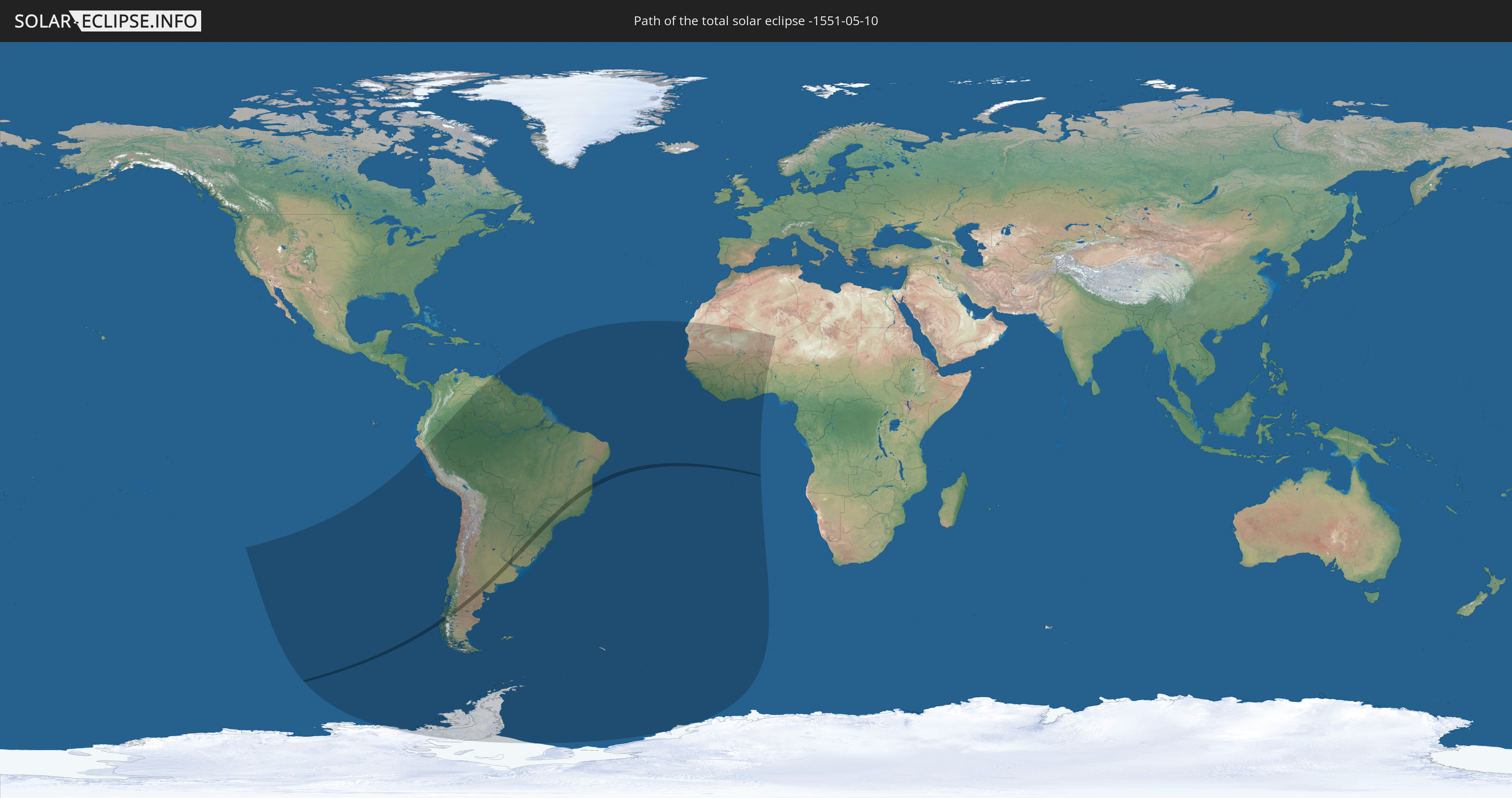
Die Sonnenfinsternis am 05/10/-1551 kann man in 33 Ländern als partielle Sonnenfinsternis beobachten.
Der Finsternispfad verläuft durch 4 Länder. Nur in diesen Ländern ist sie als total Sonnenfinsternis zu sehen.
In den folgenden Ländern ist die Sonnenfinsternis total zu sehen
 Chile
Chile
 Brazil
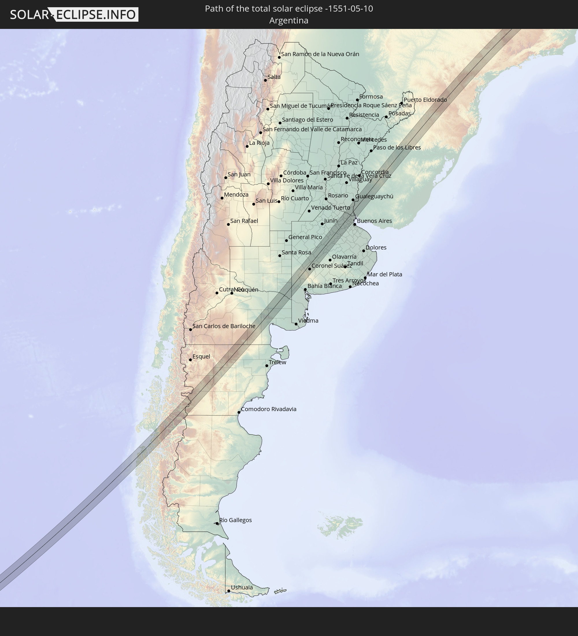 Argentina
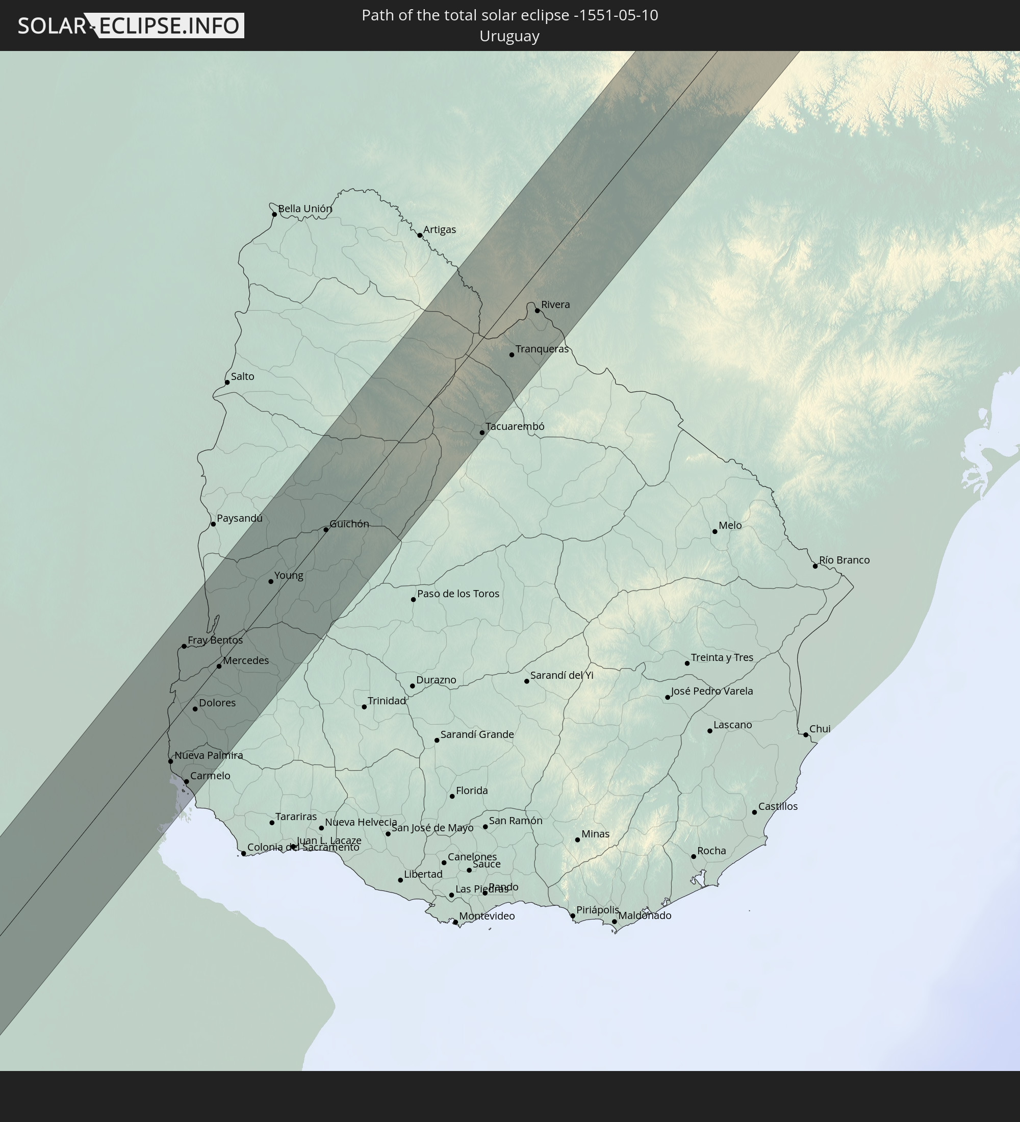 Uruguay
In den folgenden Ländern ist die Sonnenfinsternis partiell zu sehen
 Antarctica
 Chile
Chile
 Colombia
 Peru
Peru
 Brazil
 Argentina
 Venezuela
 Bolivia
 Paraguay
 Trinidad and Tobago
 Falkland Islands
 Guyana
 Uruguay
 Suriname
 French Guiana
 South Georgia and the South Sandwich Islands
 Cabo Verde
 Senegal
 Mauritania
 The Gambia
 Guinea-Bissau
 Guinea
 Saint Helena, Ascension and Tristan da Cunha
 Sierra Leone
 Mali
Mali
 Liberia
 Algeria
 Ivory Coast
 Burkina Faso
 Ghana
Ghana
 Togo
Togo
 Niger
Niger
 Benin
Benin
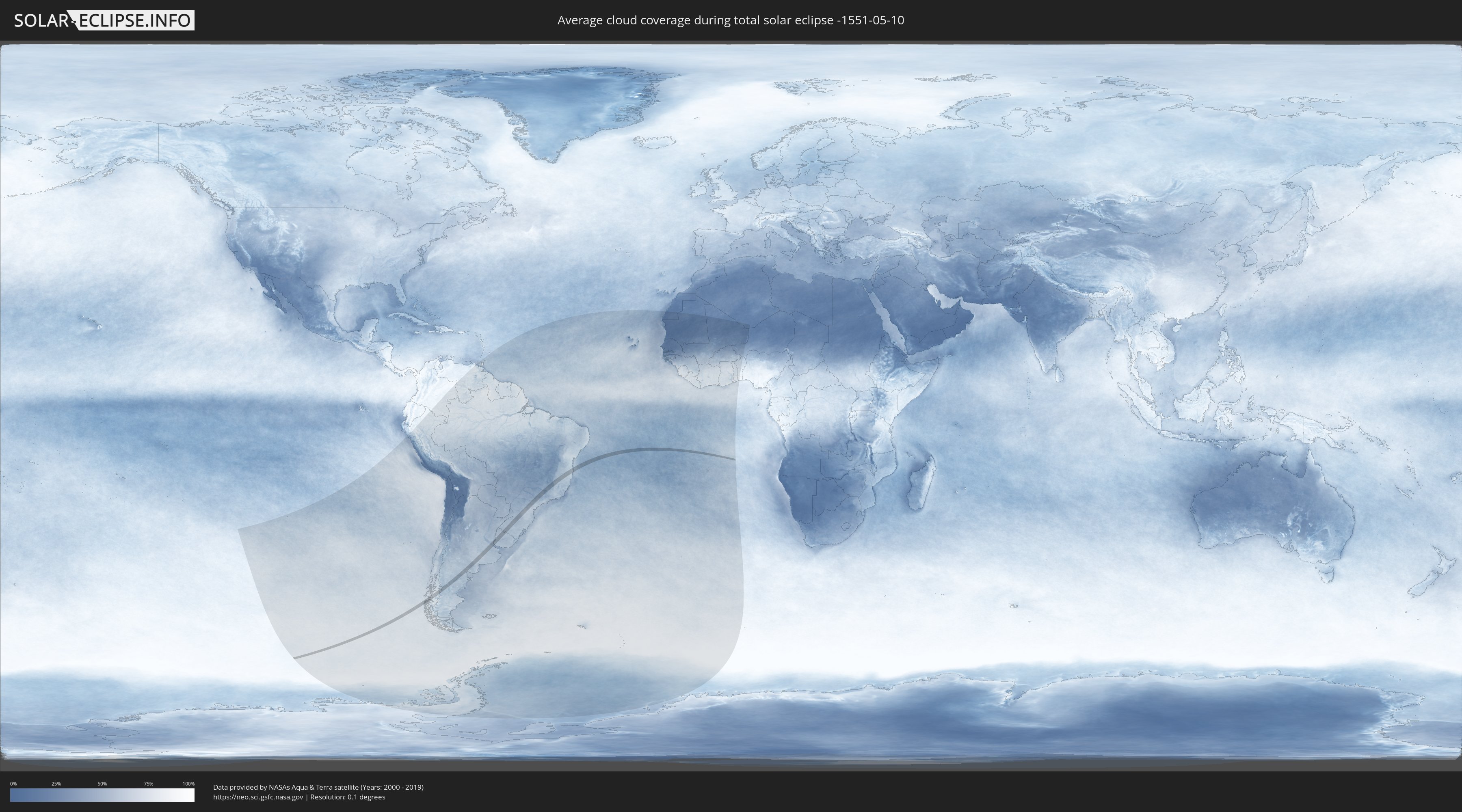
How will be the weather during the total solar eclipse on 05/10/-1551?
Where is the best place to see the total solar eclipse of 05/10/-1551?
The following maps show the average cloud coverage for the day of the total solar eclipse.
With the help of these maps, it is possible to find the place along the eclipse path, which has the best
chance of a cloudless sky.
Nevertheless, you should consider local circumstances and inform about the weather of your chosen
observation site.
The data is provided by NASAs satellites
AQUA and TERRA.
The cloud maps are averaged over a period of 19 years (2000 - 2019).

Detailed country maps
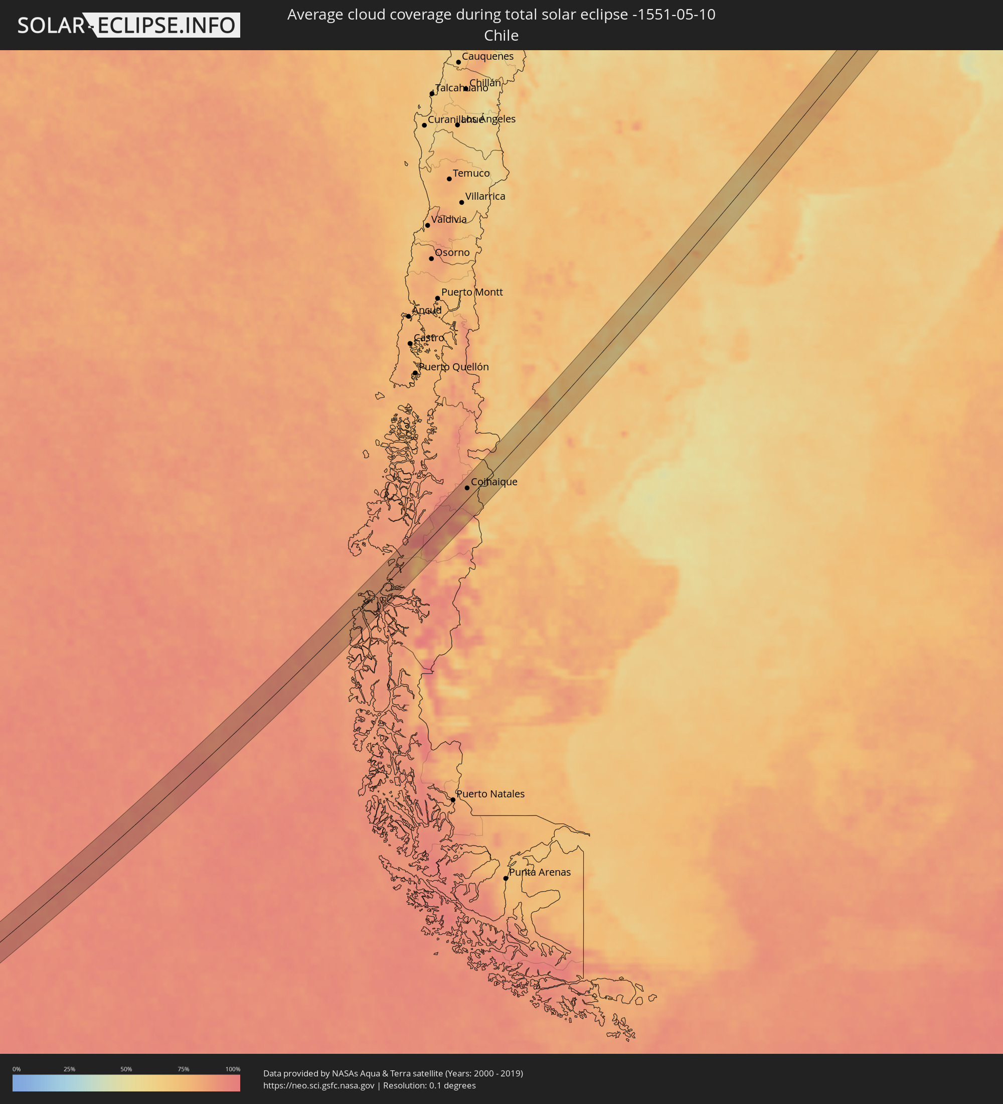 Chile
Chile
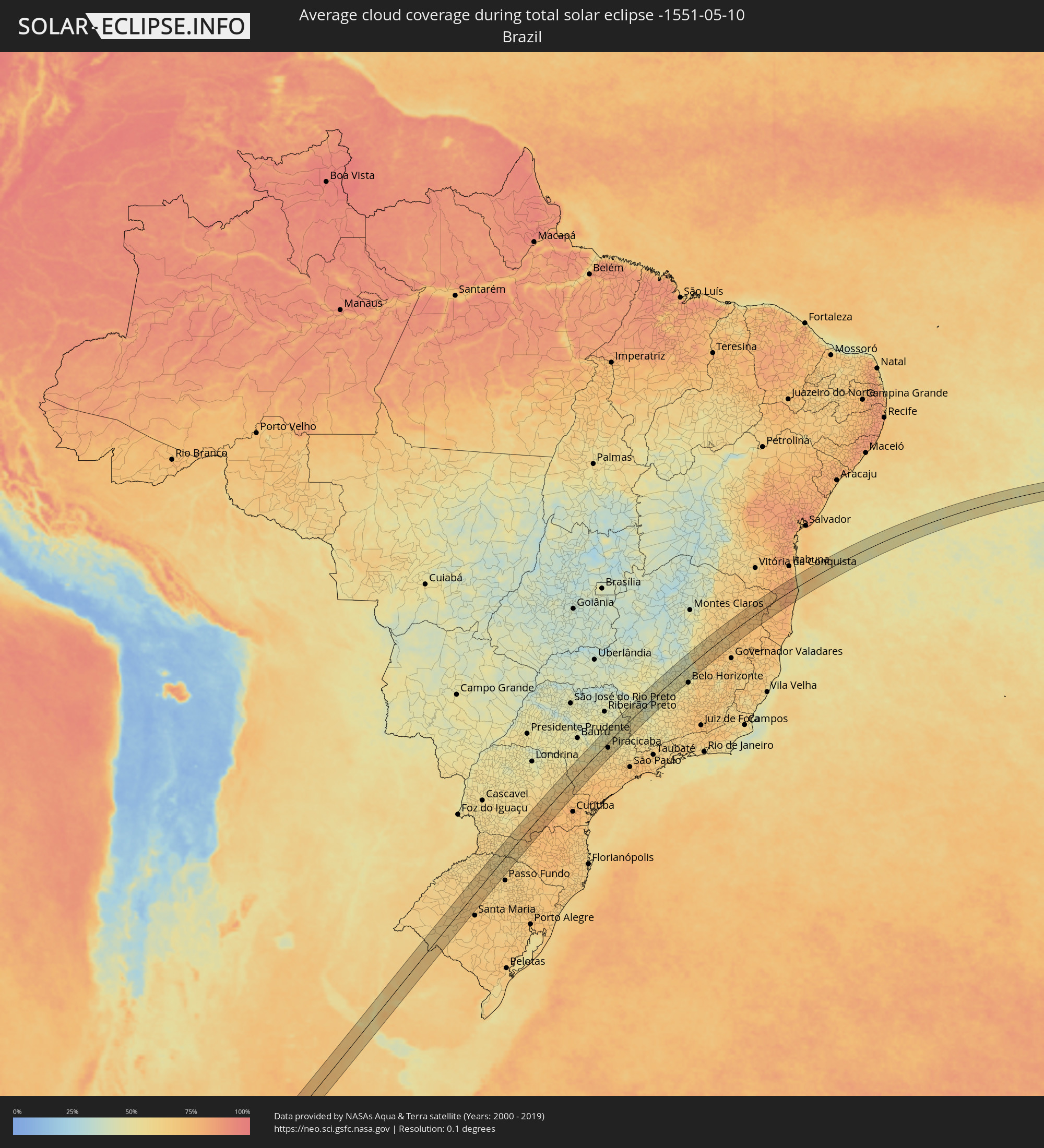 Brazil
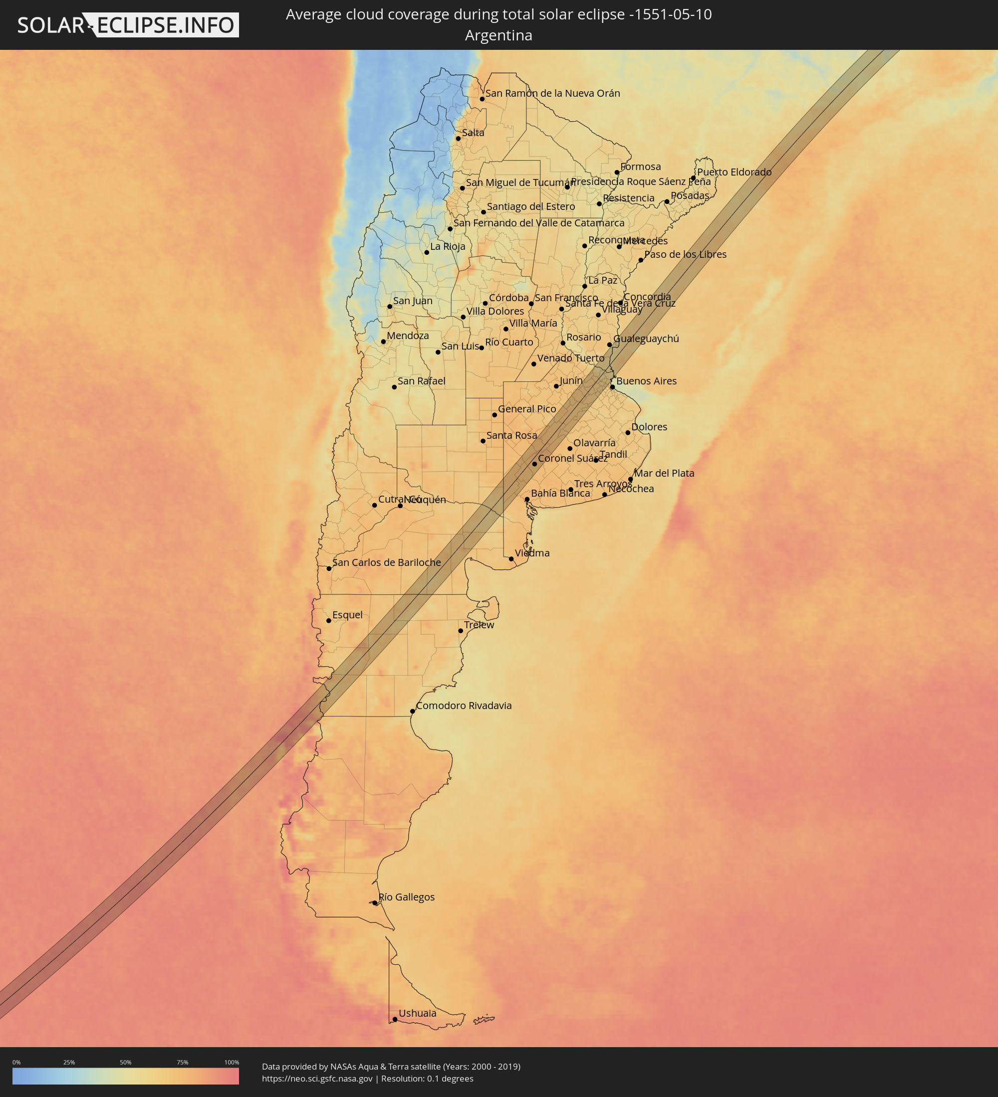 Argentina
 Uruguay
Cities inside the path of the eclipse
The following table shows all locations with a population of more than 5,000 inside the eclipse path. Cities which have more than 100,000 inhabitants are marked bold. A click at the locations opens a detailed map.
| City | Type | Eclipse duration | Local time of max. eclipse | Distance to central line | Ø Cloud coverage |
|
Coihaique, Aisén
|
total | - | 10:21:57 UTC-04:42 | 17 km | 82% |
|
Coronel Suárez, Buenos Aires
|
total | - | 11:06:29 UTC-04:16 | 21 km | 73% |
|
Veinticinco de Mayo, Buenos Aires
|
total | - | 11:11:21 UTC-04:16 | 1 km | 68% |
|
Chivilcoy, Buenos Aires
|
total | - | 11:12:11 UTC-04:16 | 26 km | 69% |
|
Mercedes, Buenos Aires
|
total | - | 11:13:27 UTC-04:16 | 1 km | 67% |
|
Luján, Buenos Aires
|
total | - | 11:14:06 UTC-04:16 | 16 km | 67% |
|
Zárate, Buenos Aires
|
total | - | 11:14:47 UTC-04:16 | 11 km | 65% |
|
Campana, Buenos Aires
|
total | - | 11:14:49 UTC-04:16 | 1 km | 67% |
|
Tigre, Buenos Aires
|
total | - | 11:15:10 UTC-04:16 | 44 km | 62% |
|
Nueva Palmira, Colonia
|
total | - | 11:48:04 UTC-03:44 | 17 km | 58% |
|
Fray Bentos, Río Negro
|
total | - | 11:49:09 UTC-03:44 | 28 km | 56% |
|
Carmelo, Colonia
|
total | - | 11:48:08 UTC-03:44 | 35 km | 57% |
|
Dolores, Soriano
|
total | - | 11:48:49 UTC-03:44 | 7 km | 67% |
|
Mercedes, Soriano
|
total | - | 11:49:29 UTC-03:44 | 1 km | 66% |
|
Young, Río Negro
|
total | - | 11:50:53 UTC-03:44 | 8 km | 65% |
|
Guichón, Paysandú
|
total | - | 11:52:05 UTC-03:44 | 1 km | 63% |
|
Tacuarembó, Tacuarembó
|
total | - | 11:55:10 UTC-03:44 | 44 km | 67% |
|
Tranqueras, Rivera
|
total | - | 11:56:18 UTC-03:44 | 25 km | 65% |
|
Rivera, Rivera
|
total | - | 11:57:04 UTC-03:44 | 19 km | 67% |
|
Santana do Livramento, Rio Grande do Sul
|
total | - | 12:35:31 UTC-03:06 | 20 km | 67% |
|
Rosário do Sul, Rio Grande do Sul
|
total | - | 12:37:35 UTC-03:06 | 21 km | 63% |
|
Ijuí, Rio Grande do Sul
|
total | - | 12:42:17 UTC-03:06 | 36 km | 63% |
|
Cruz Alta, Rio Grande do Sul
|
total | - | 12:42:31 UTC-03:06 | 5 km | 67% |
|
Carazinho, Rio Grande do Sul
|
total | - | 12:44:41 UTC-03:06 | 42 km | 65% |
|
Chapecó, Santa Catarina
|
total | - | 12:46:54 UTC-03:06 | 31 km | 62% |
|
Erechim, Rio Grande do Sul
|
total | - | 12:46:44 UTC-03:06 | 34 km | 63% |
|
Concórdia, Santa Catarina
|
total | - | 12:47:52 UTC-03:06 | 24 km | 61% |
|
Palmas, Paraná
|
total | - | 12:49:10 UTC-03:06 | 27 km | 63% |
|
União da Vitória, Paraná
|
total | - | 12:51:27 UTC-03:06 | 22 km | 76% |
|
Irati, Paraná
|
total | - | 12:53:38 UTC-03:06 | 1 km | 75% |
|
Ponta Grossa, Paraná
|
total | - | 12:55:17 UTC-03:06 | 9 km | 68% |
|
Castro, Paraná
|
total | - | 12:56:08 UTC-03:06 | 3 km | 68% |
|
Itararé, São Paulo
|
total | - | 12:58:45 UTC-03:06 | 2 km | 60% |
|
Avaré, São Paulo
|
total | - | 13:01:25 UTC-03:06 | 49 km | 56% |
|
Itapeva, São Paulo
|
total | - | 12:59:57 UTC-03:06 | 22 km | 62% |
|
Botucatu, São Paulo
|
total | - | 13:02:50 UTC-03:06 | 29 km | 56% |
|
Tatuí, São Paulo
|
total | - | 13:03:15 UTC-03:06 | 51 km | 64% |
|
Piracicaba, São Paulo
|
total | - | 13:04:50 UTC-03:06 | 17 km | 58% |
|
Rio Claro, São Paulo
|
total | - | 13:05:36 UTC-03:06 | 1 km | 55% |
|
Porto Ferreira, São Paulo
|
total | - | 13:06:48 UTC-03:06 | 38 km | 50% |
|
Pirassununga, São Paulo
|
total | - | 13:06:39 UTC-03:06 | 23 km | 50% |
|
Limeira, São Paulo
|
total | - | 13:05:40 UTC-03:06 | 23 km | 55% |
|
Leme, São Paulo
|
total | - | 13:06:23 UTC-03:06 | 6 km | 51% |
|
Araras, São Paulo
|
total | - | 13:06:05 UTC-03:06 | 8 km | 53% |
|
Americana, São Paulo
|
total | - | 13:05:30 UTC-03:06 | 42 km | 56% |
|
Cosmópolis, São Paulo
|
total | - | 13:05:57 UTC-03:06 | 45 km | 54% |
|
Mococa, São Paulo
|
total | - | 13:08:33 UTC-03:06 | 34 km | 49% |
|
Mogi-Gaucu, São Paulo
|
total | - | 13:07:00 UTC-03:06 | 41 km | 53% |
|
São José do Rio Pardo, São Paulo
|
total | - | 13:08:33 UTC-03:06 | 15 km | 53% |
|
São João da Boa Vista, São Paulo
|
total | - | 13:08:04 UTC-03:06 | 21 km | 53% |
|
Guaxupé, Minas Gerais
|
total | - | 13:09:29 UTC-03:06 | 26 km | 51% |
|
Espírito Santo do Pinhal, São Paulo
|
total | - | 13:08:02 UTC-03:06 | 41 km | 53% |
|
Poços de Caldas, Minas Gerais
|
total | - | 13:08:55 UTC-03:06 | 24 km | 55% |
|
Alfenas, Minas Gerais
|
total | - | 13:10:55 UTC-03:06 | 40 km | 46% |
|
Lagoa da Prata, Minas Gerais
|
total | - | 13:14:26 UTC-03:06 | 46 km | 50% |
|
Formiga, Minas Gerais
|
total | - | 13:13:51 UTC-03:06 | 1 km | 49% |
|
Campo Belo, Minas Gerais
|
total | - | 13:13:22 UTC-03:06 | 45 km | 52% |
|
Bom Despacho, Minas Gerais
|
total | - | 13:15:37 UTC-03:06 | 49 km | 48% |
|
Divinópolis, Minas Gerais
|
total | - | 13:15:38 UTC-03:06 | 10 km | 50% |
|
Pará de Minas, Minas Gerais
|
total | - | 13:16:47 UTC-03:06 | 7 km | 49% |
|
Itaúna, Minas Gerais
|
total | - | 13:16:27 UTC-03:06 | 27 km | 52% |
|
Esmeraldas, Minas Gerais
|
total | - | 13:17:37 UTC-03:06 | 19 km | 51% |
|
Sete Lagoas, Minas Gerais
|
total | - | 13:18:20 UTC-03:06 | 1 km | 47% |
|
Betim, Minas Gerais
|
total | - | 13:17:29 UTC-03:06 | 44 km | 52% |
|
Ribeirão das Neves, Minas Gerais
|
total | - | 13:18:06 UTC-03:06 | 35 km | 54% |
|
Contagem, Minas Gerais
|
total | - | 13:17:52 UTC-03:06 | 51 km | 54% |
|
Pedro Leopoldo, Minas Gerais
|
total | - | 13:18:29 UTC-03:06 | 25 km | 49% |
|
Santa Luzia, Minas Gerais
|
total | - | 13:18:37 UTC-03:06 | 51 km | 53% |
|
Teófilo Otoni, Minas Gerais
|
total | - | 13:27:23 UTC-03:06 | 42 km | 71% |