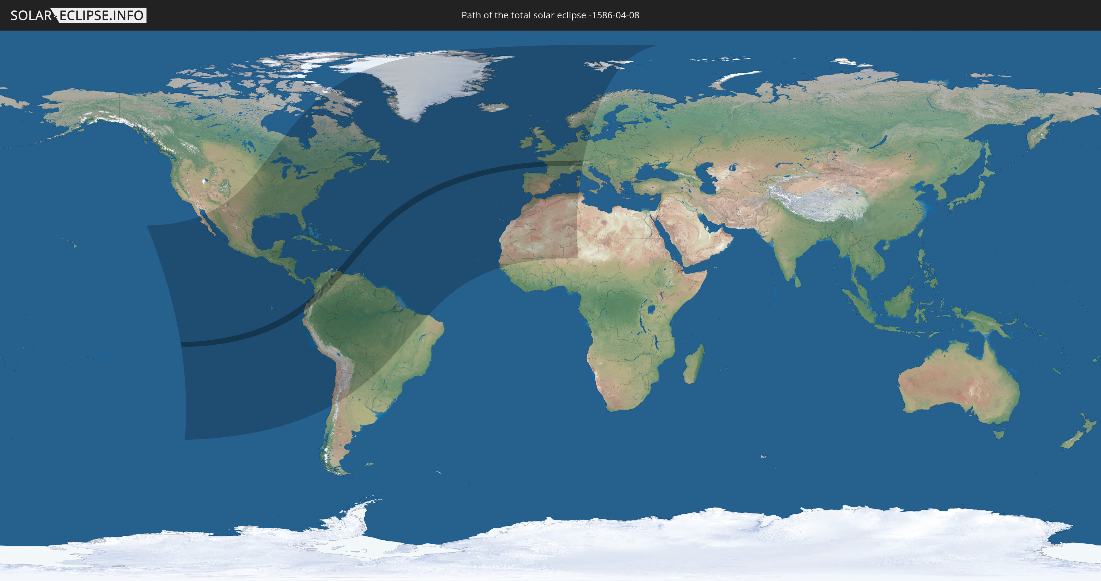
Total solar eclipse of 04/08/-1586
| Day of week: | Sunday |
| Maximum duration of eclipse: | 05m16s |
| Maximum width of eclipse path: | 222 km |
| Saros cycle: | 23 |
| Coverage: | 100% |
| Magnitude: | 1.0653 |
| Gamma: | 0.2911 |
Wo kann man die Sonnenfinsternis vom 04/08/-1586 sehen?
Die Sonnenfinsternis am 04/08/-1586 kann man in 85 Ländern als partielle Sonnenfinsternis beobachten.
Der Finsternispfad verläuft durch 17 Länder. Nur in diesen Ländern ist sie als total Sonnenfinsternis zu sehen.
In den folgenden Ländern ist die Sonnenfinsternis total zu sehen
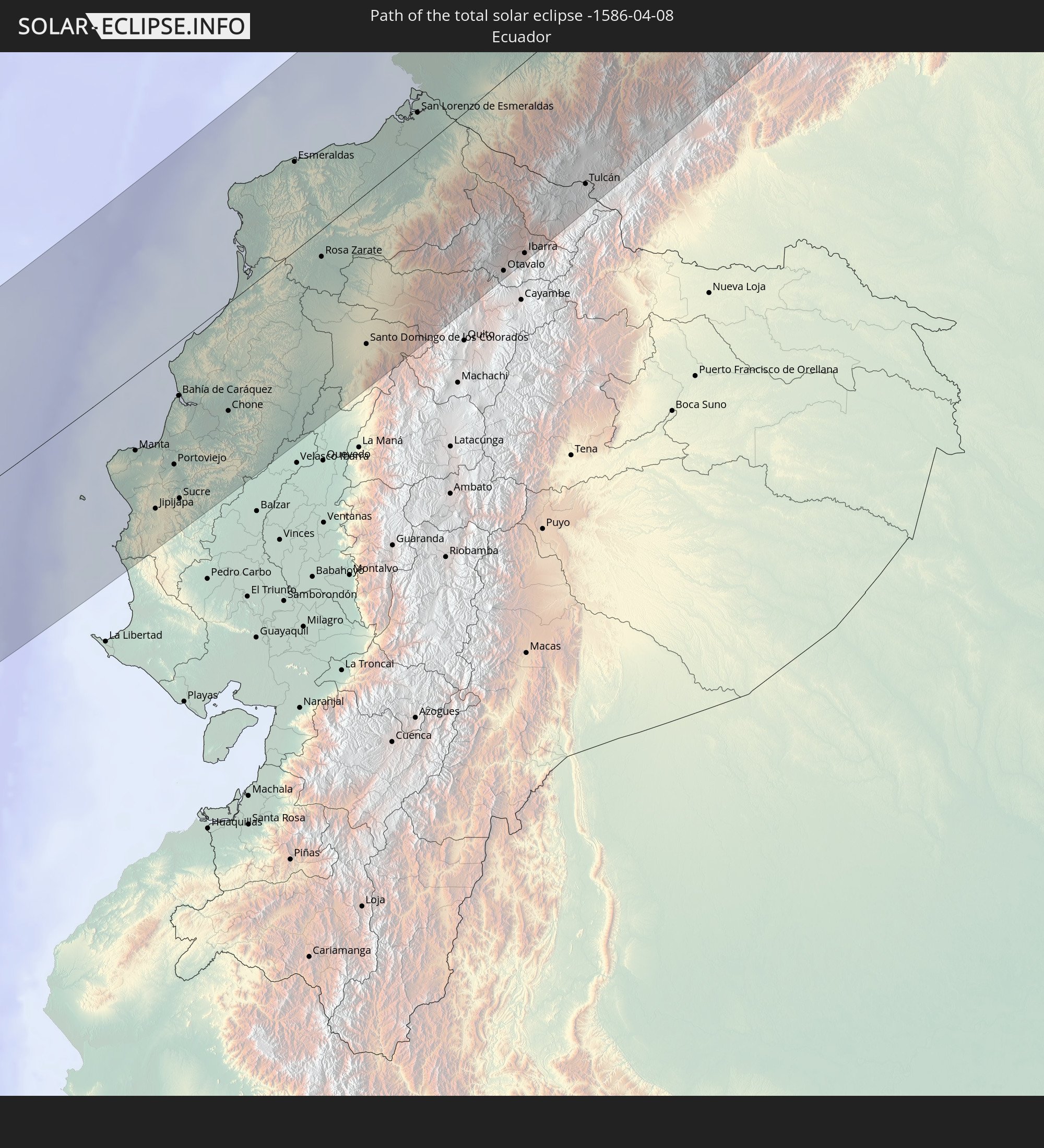 Ecuador
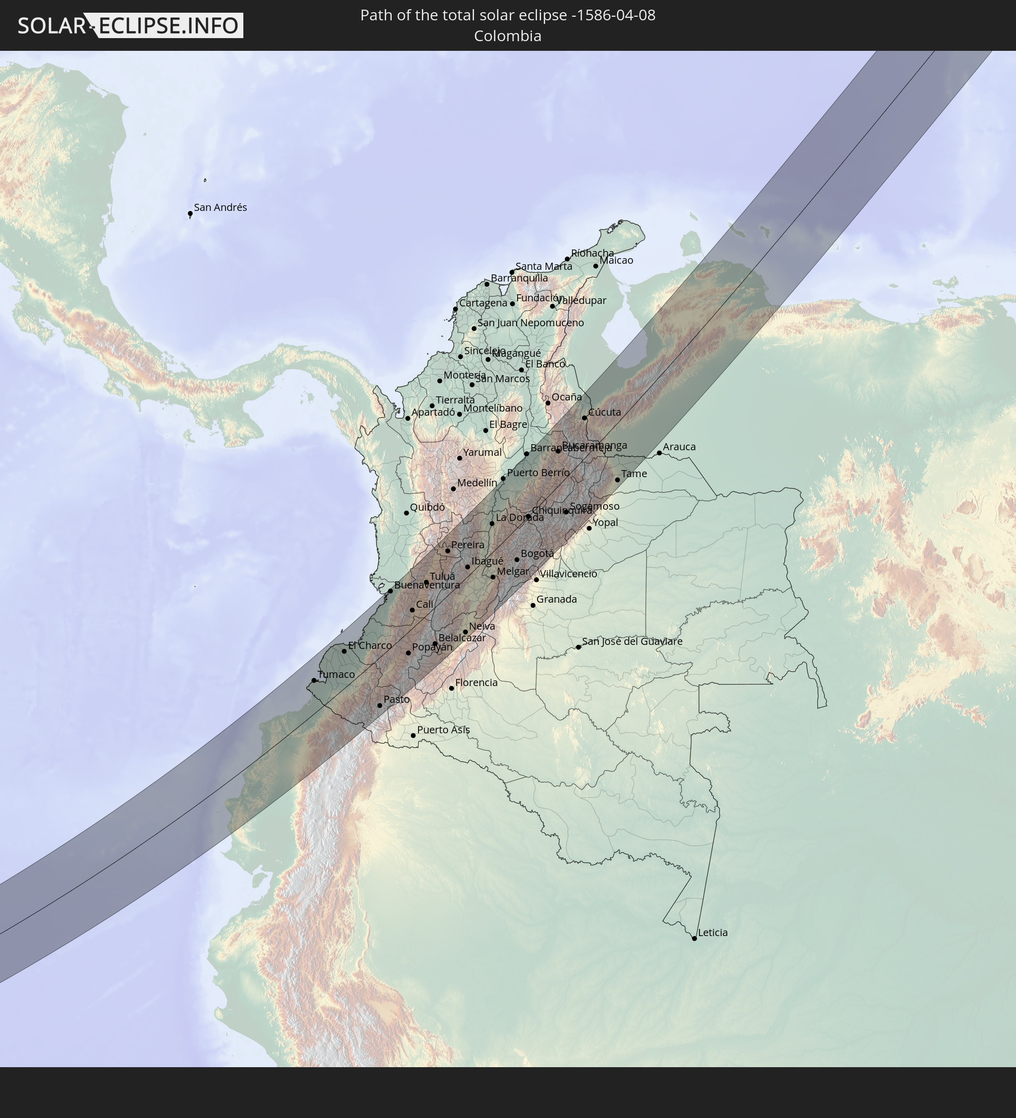 Colombia
 Venezuela
 Curaçao
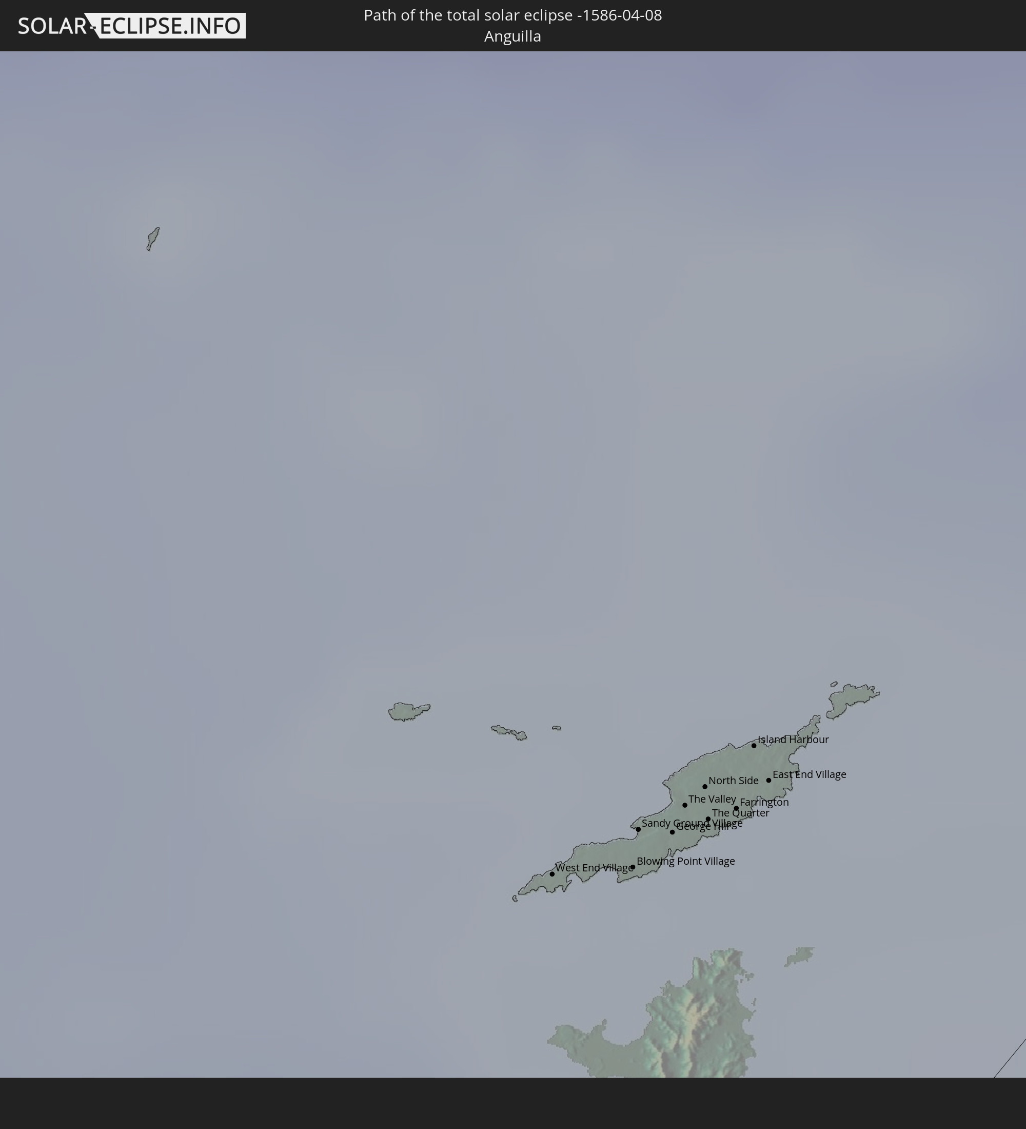 Anguilla
 Sint Maarten
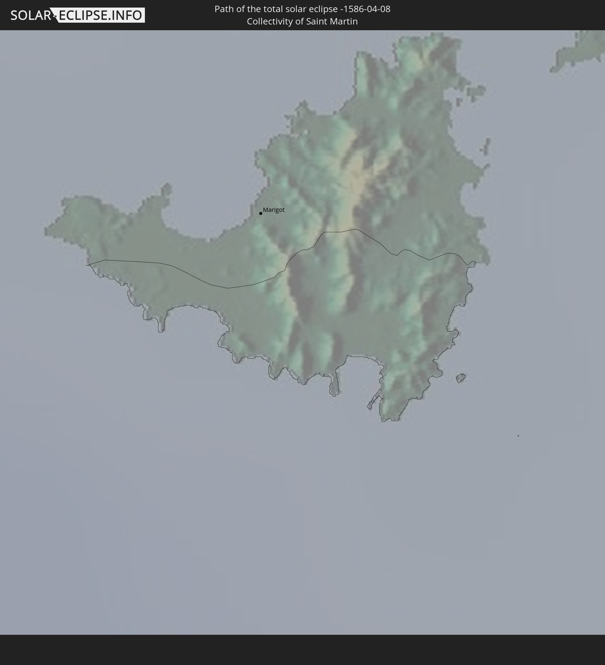 Collectivity of Saint Martin
 Saint Barthélemy
 Saint Kitts and Nevis
 Antigua and Barbuda
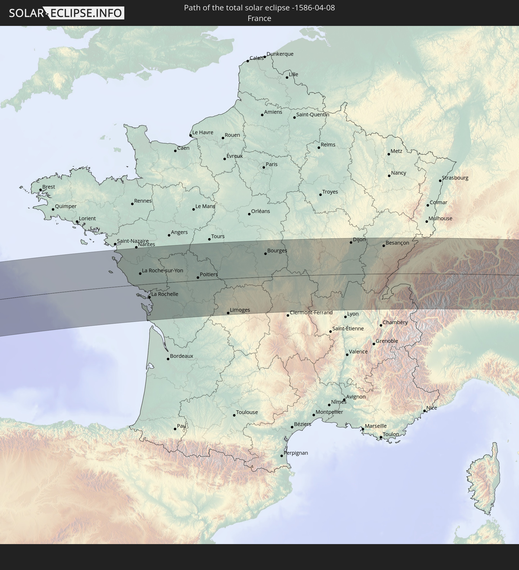 France
 Caribbean Netherlands
 Germany
 Switzerland
 Italy
Italy
 Liechtenstein
 Austria
In den folgenden Ländern ist die Sonnenfinsternis partiell zu sehen
 United States
 United States Minor Outlying Islands
 Canada
 Mexico
 Chile
Chile
 Greenland
 Guatemala
 Ecuador
 El Salvador
 Honduras
 Belize
 Nicaragua
 Costa Rica
 Cuba
Cuba
 Panama
 Colombia
 Cayman Islands
 Peru
Peru
 The Bahamas
 Jamaica
 Haiti
Haiti
 Brazil
 Argentina
 Venezuela
 Turks and Caicos Islands
 Dominican Republic
 Aruba
Aruba
 Bolivia
 Puerto Rico
 United States Virgin Islands
 Bermuda
 British Virgin Islands
 Anguilla
 Collectivity of Saint Martin
 Saint Barthélemy
 Saint Kitts and Nevis
 Paraguay
 Antigua and Barbuda
 Montserrat
 Trinidad and Tobago
 Guadeloupe
 Grenada
 Dominica
 Saint Vincent and the Grenadines
 Guyana
 Martinique
 Saint Lucia
 Barbados
 Suriname
 Saint Pierre and Miquelon
 French Guiana
 Portugal
 Cabo Verde
 Iceland
 Spain
Spain
 Senegal
 Mauritania
 The Gambia
 Morocco
 Mali
Mali
 Republic of Ireland
 Svalbard and Jan Mayen
 Algeria
 United Kingdom
 Faroe Islands
 Gibraltar
 France
 Isle of Man
 Guernsey
 Jersey
 Niger
Niger
 Andorra
 Belgium
 Netherlands
 Norway
 Luxembourg
 Germany
 Switzerland
 Italy
Italy
 Monaco
 Tunisia
 Denmark
 Liechtenstein
 Austria
 Sweden
How will be the weather during the total solar eclipse on 04/08/-1586?
Where is the best place to see the total solar eclipse of 04/08/-1586?
The following maps show the average cloud coverage for the day of the total solar eclipse.
With the help of these maps, it is possible to find the place along the eclipse path, which has the best
chance of a cloudless sky.
Nevertheless, you should consider local circumstances and inform about the weather of your chosen
observation site.
The data is provided by NASAs satellites
AQUA and TERRA.
The cloud maps are averaged over a period of 19 years (2000 - 2019).


Detailed country maps
 Ecuador
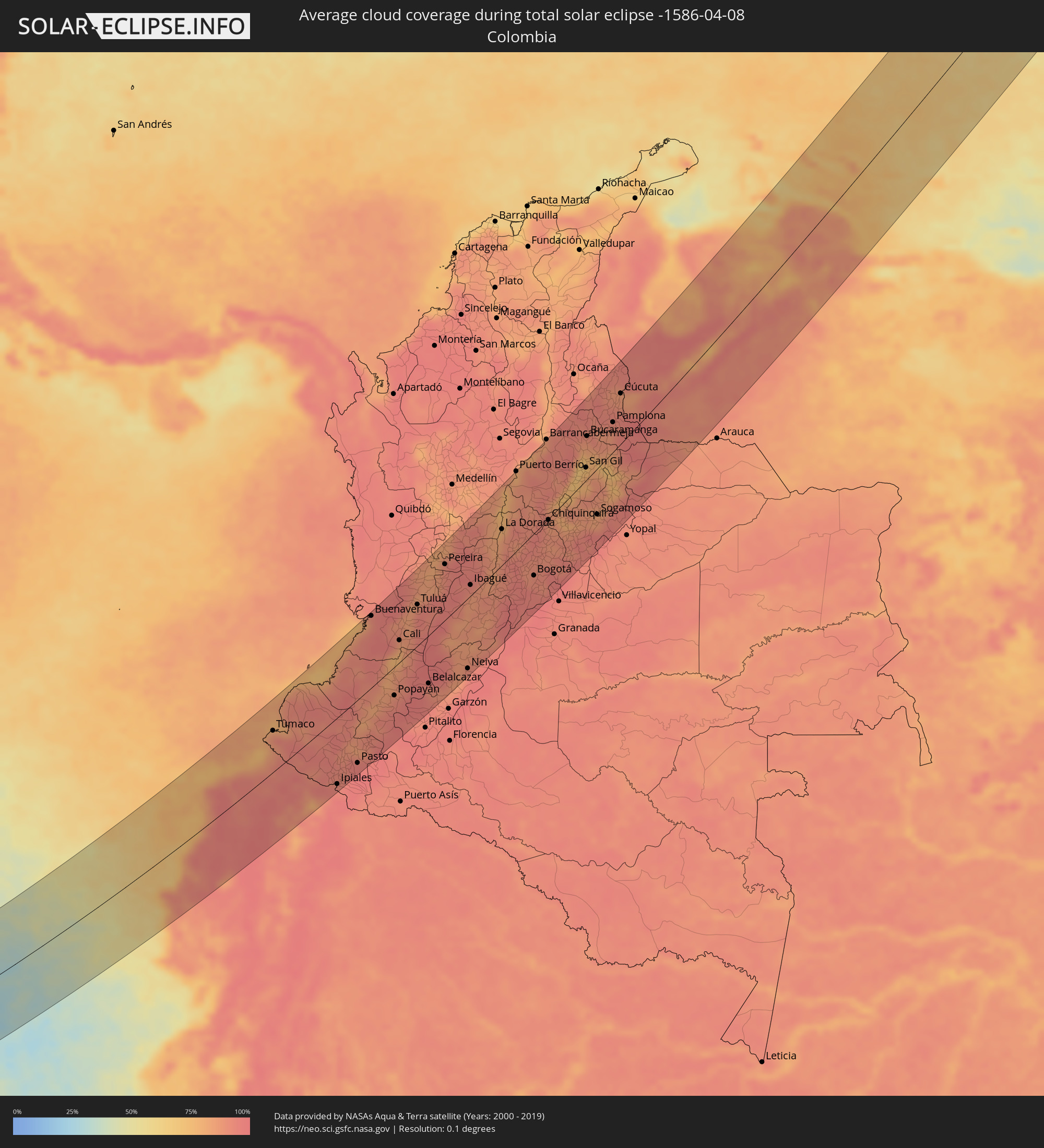 Colombia
 Venezuela
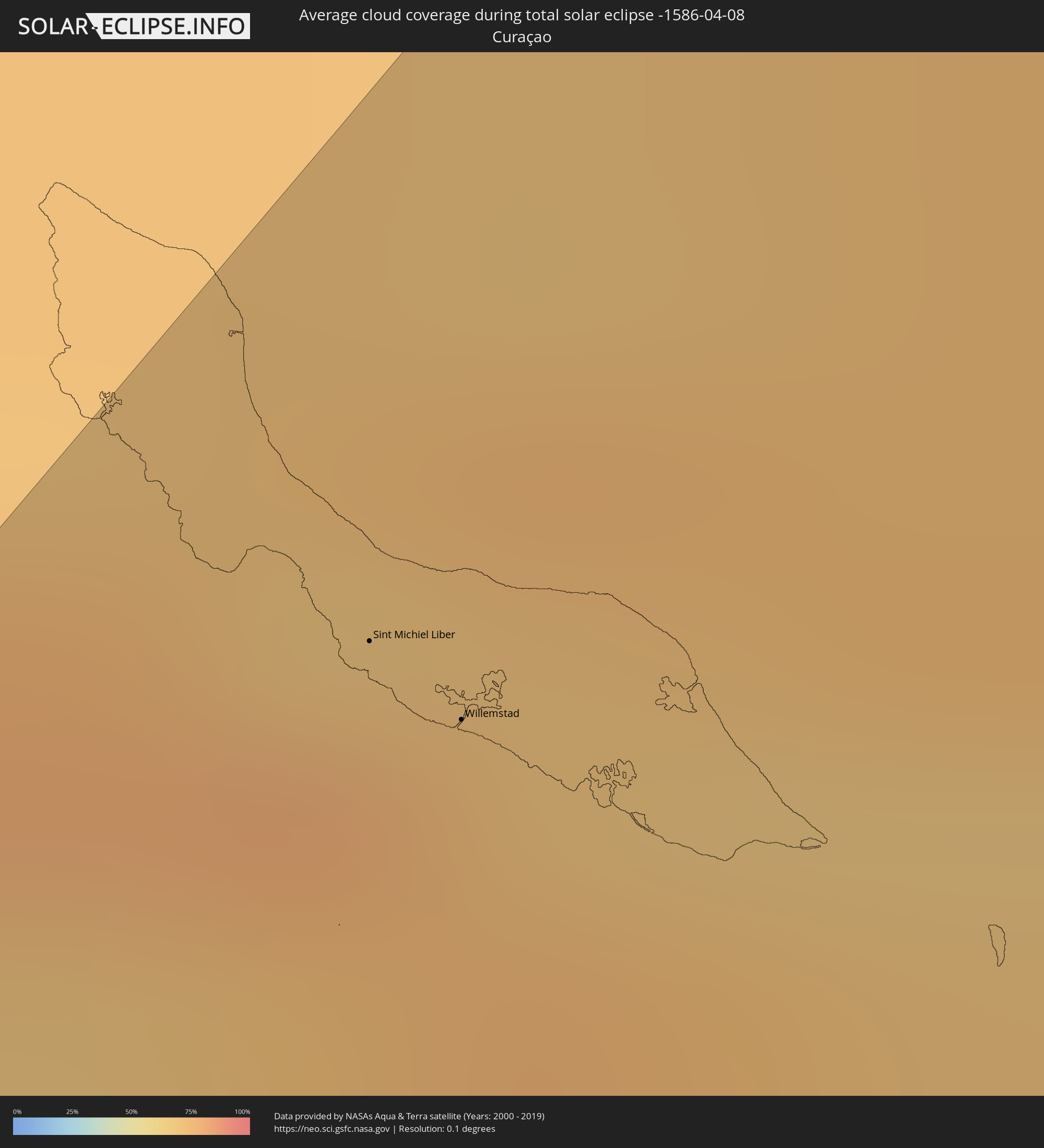 Curaçao
 Anguilla
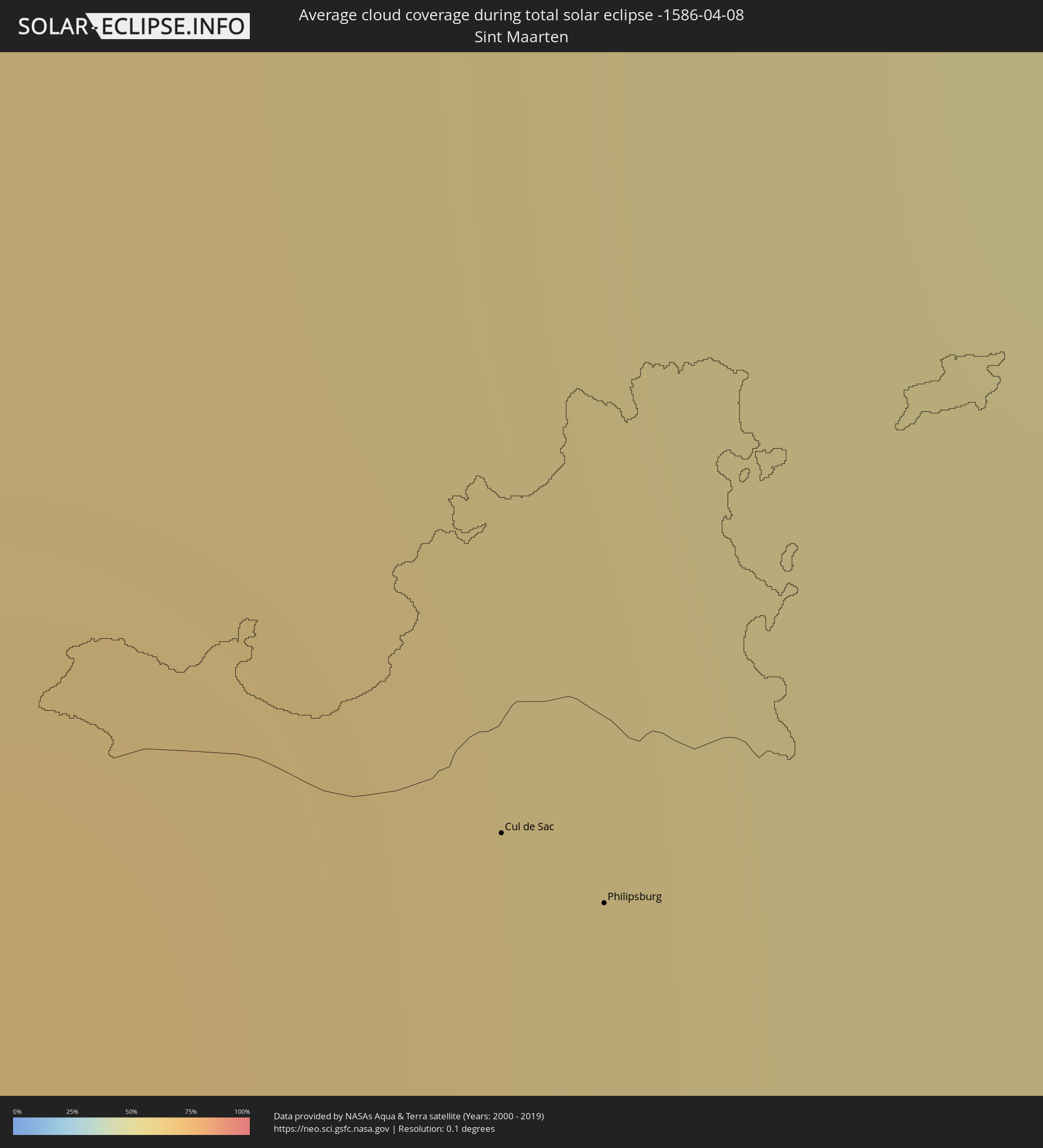 Sint Maarten
 Collectivity of Saint Martin
 Saint Barthélemy
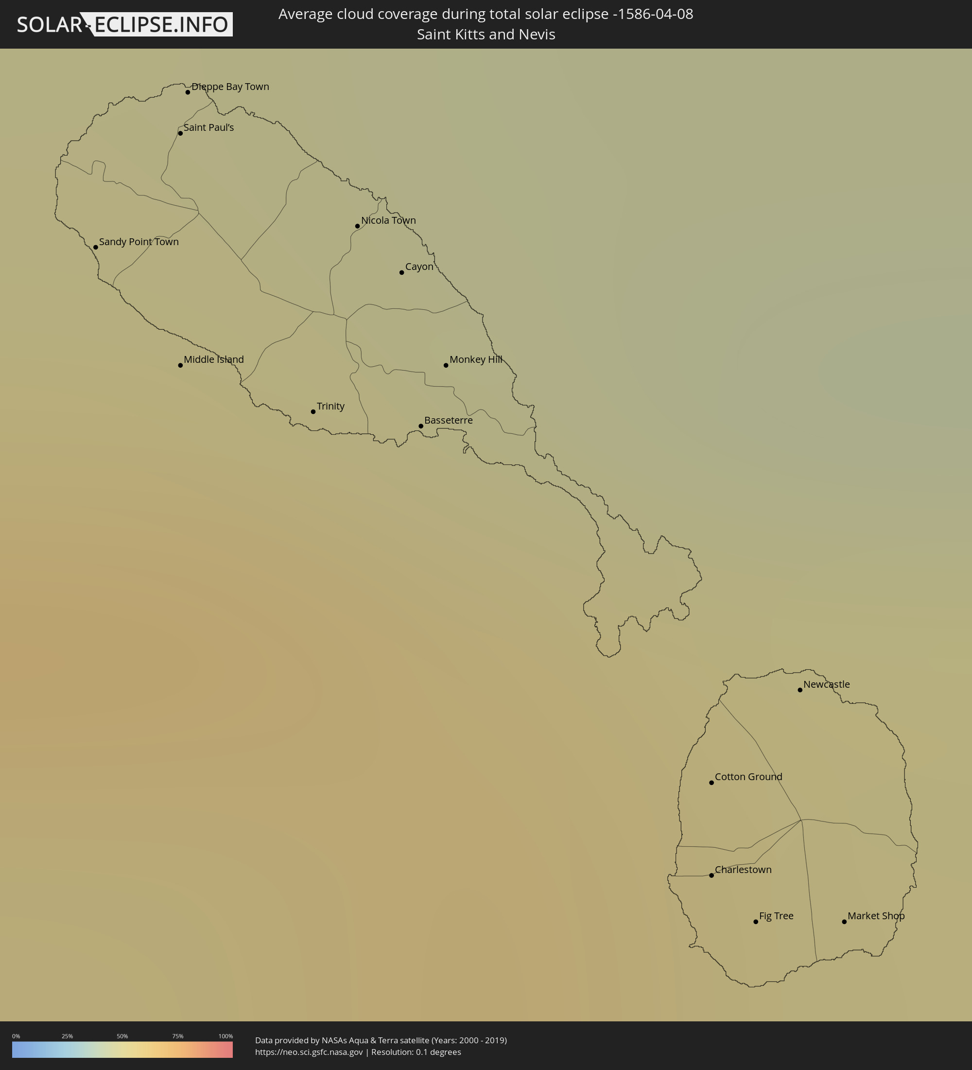 Saint Kitts and Nevis
 Antigua and Barbuda
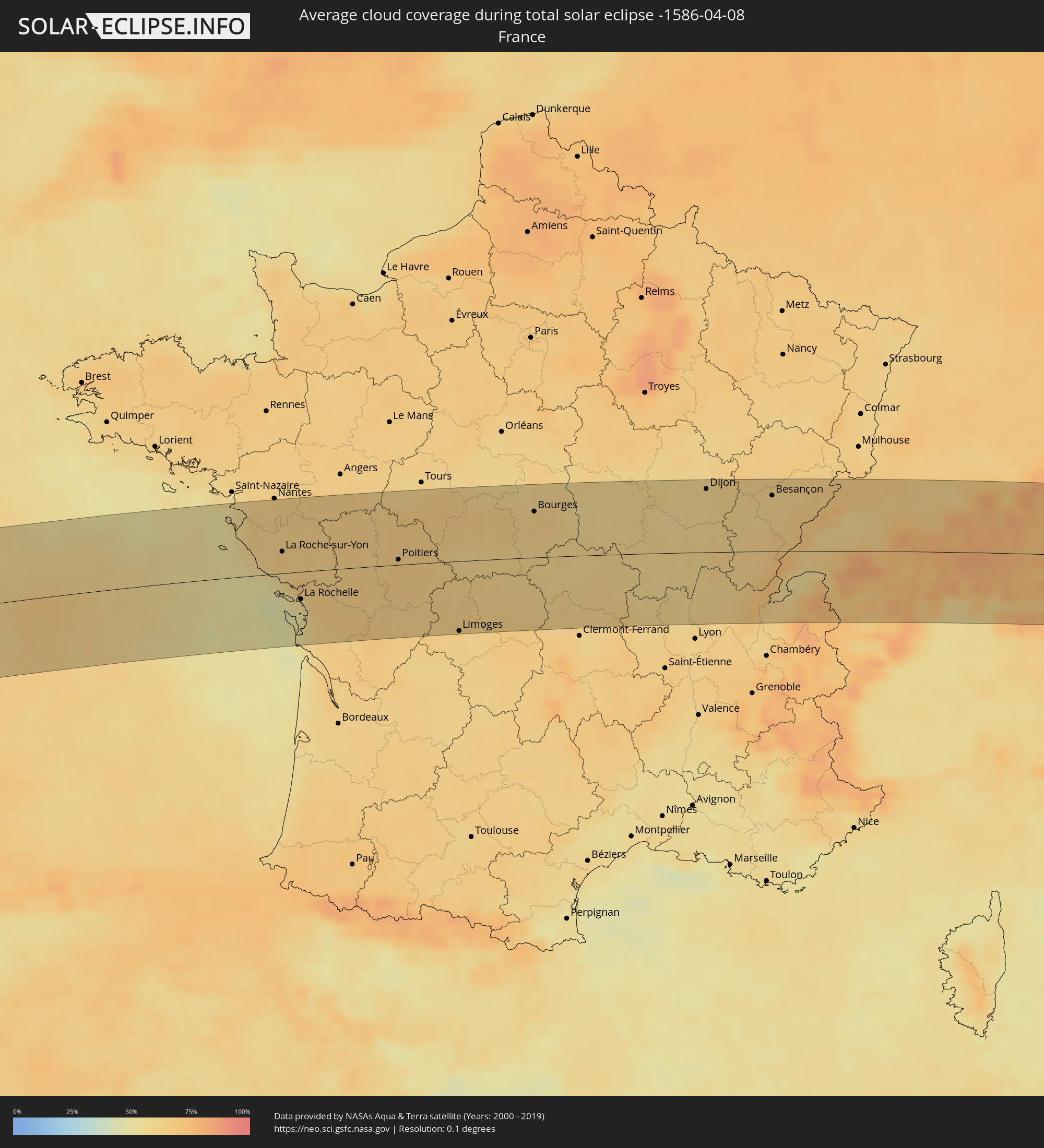 France
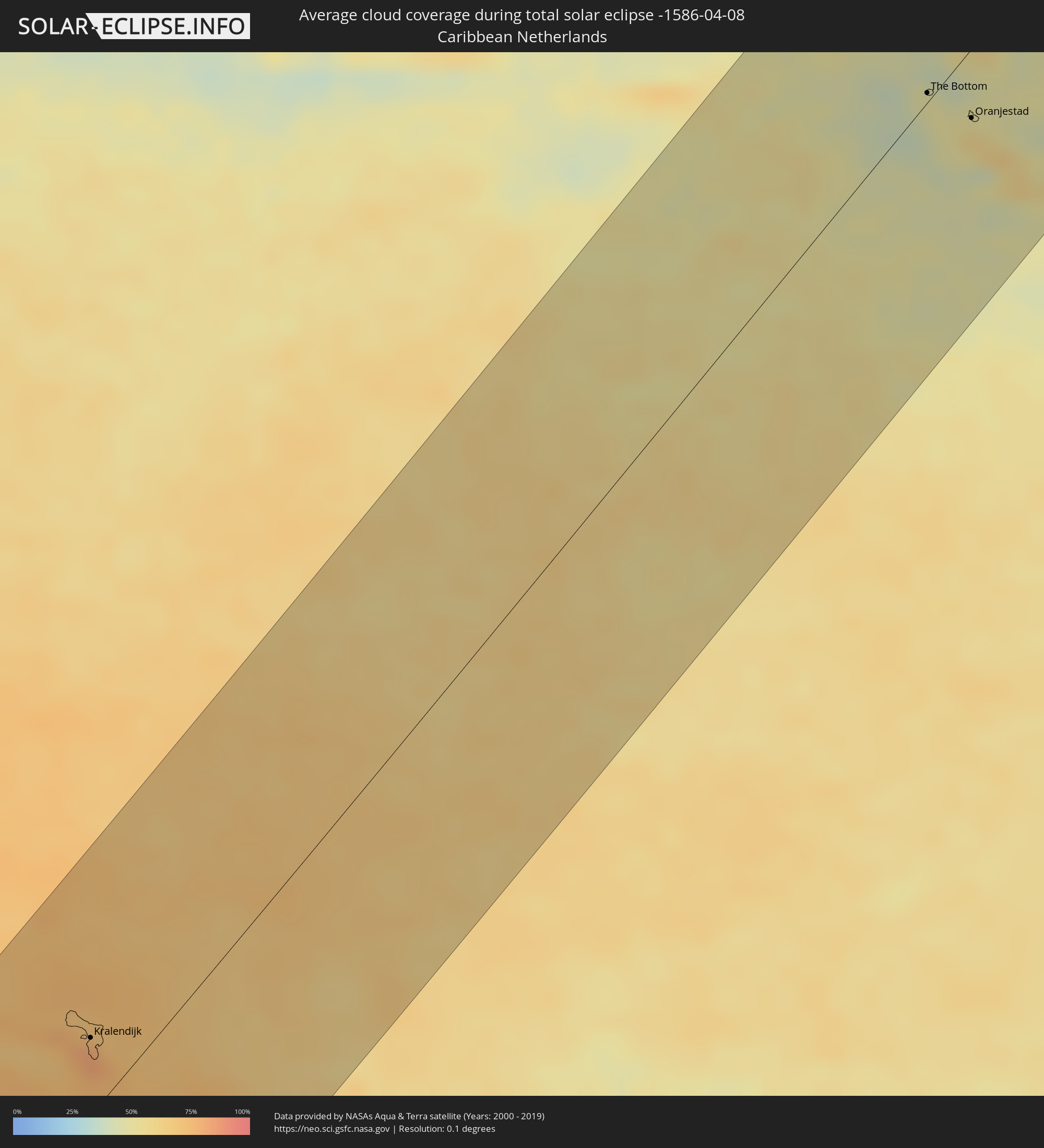 Caribbean Netherlands
 Germany
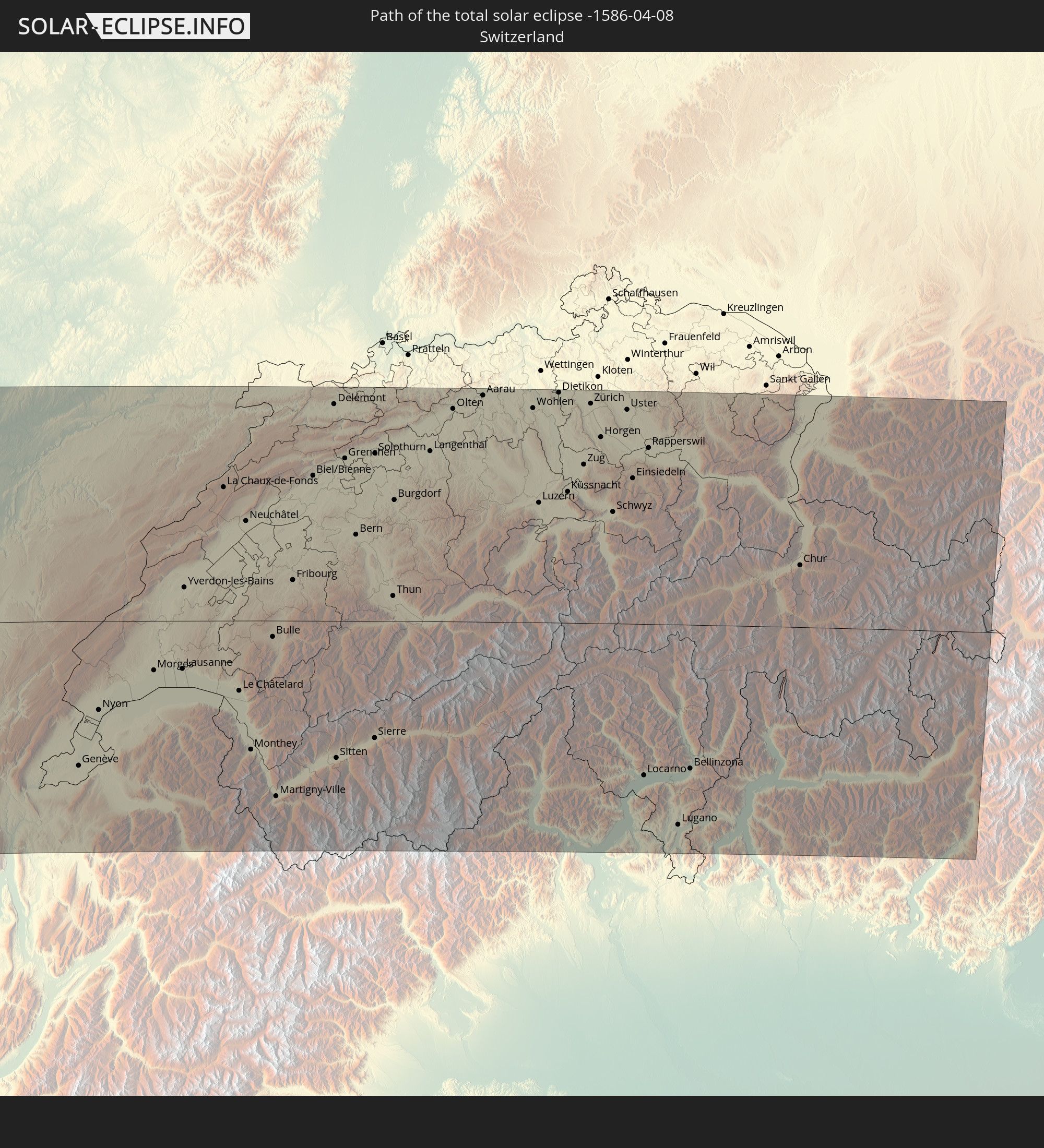
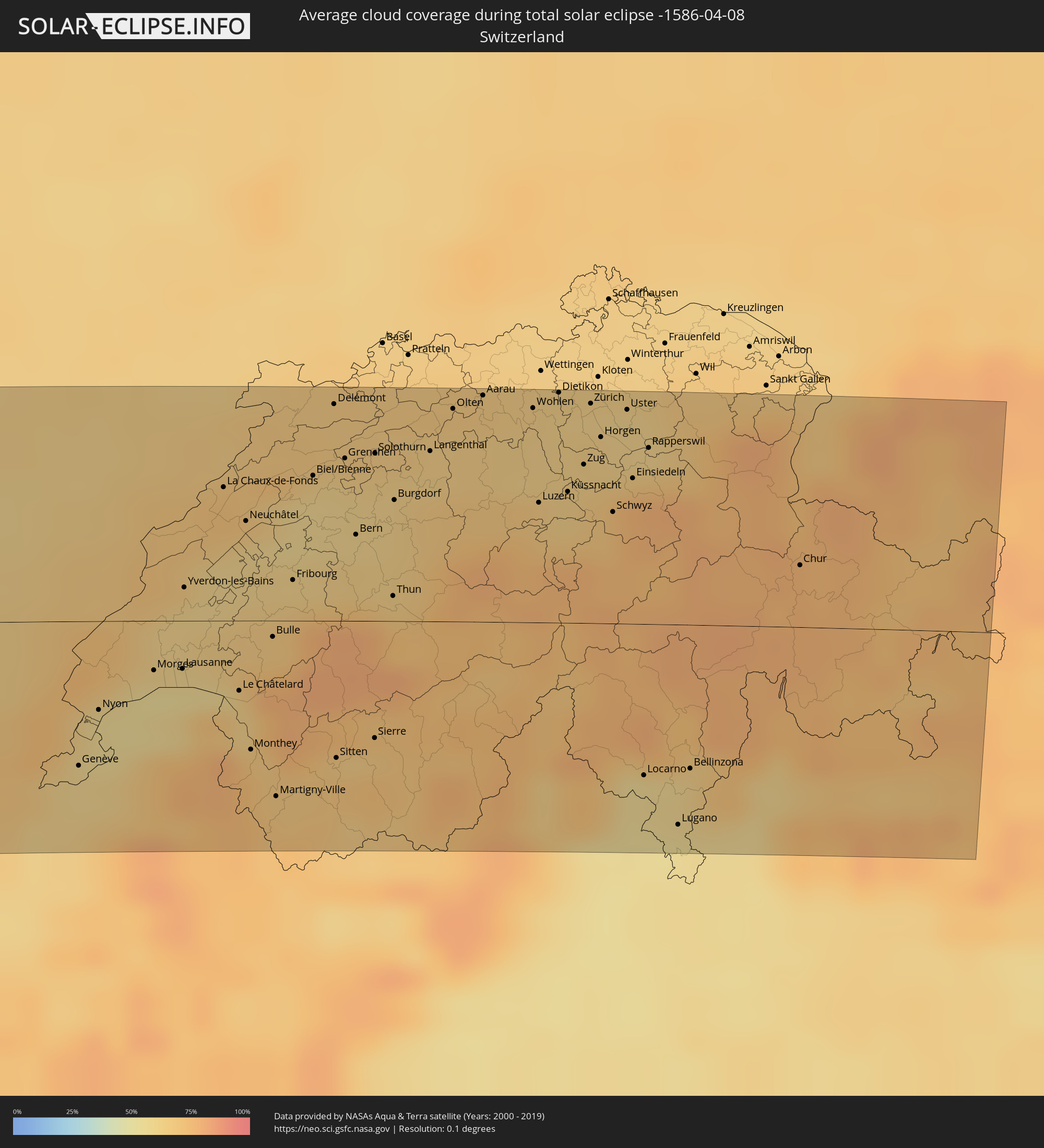 Switzerland
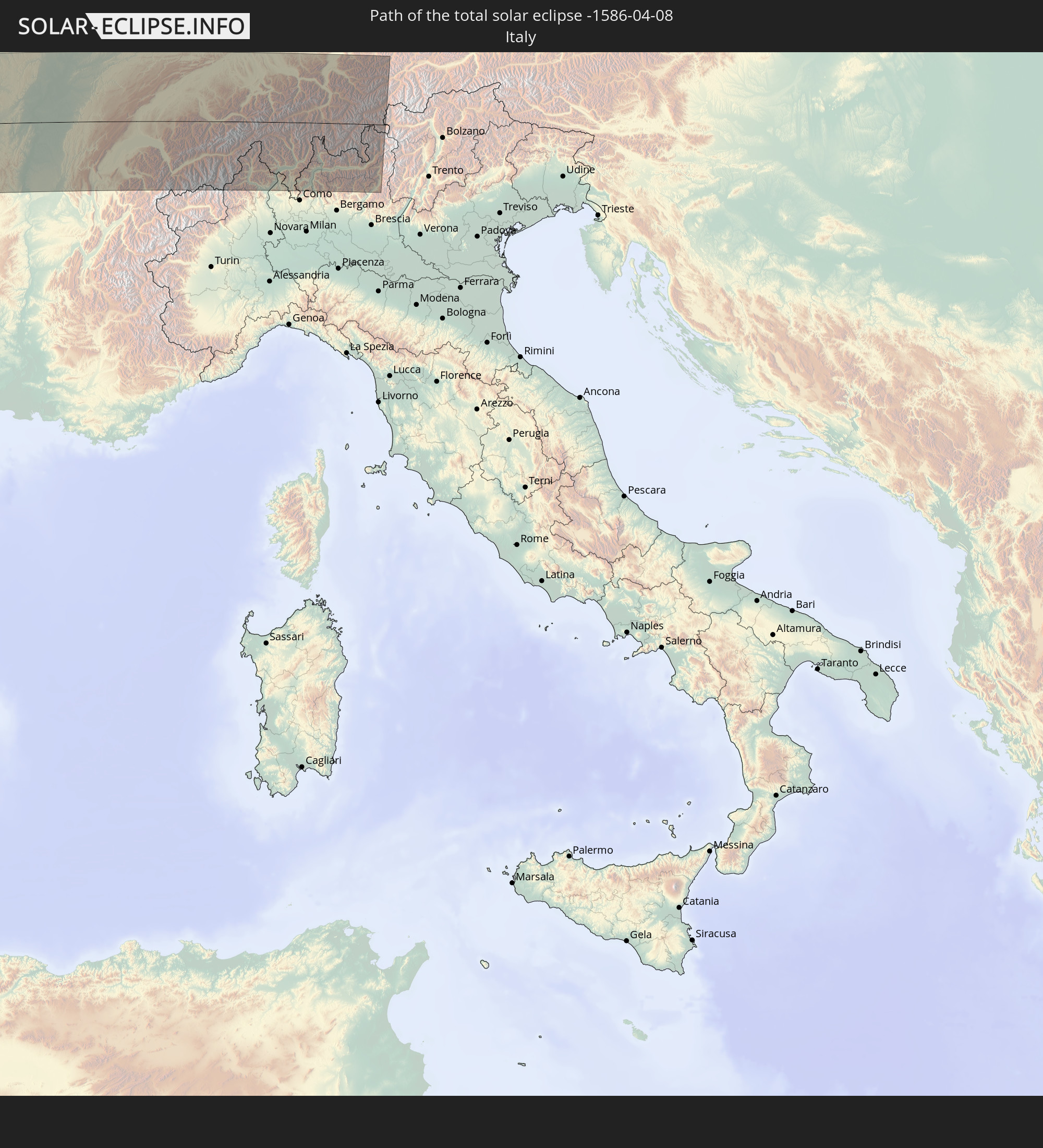
 Italy
Italy
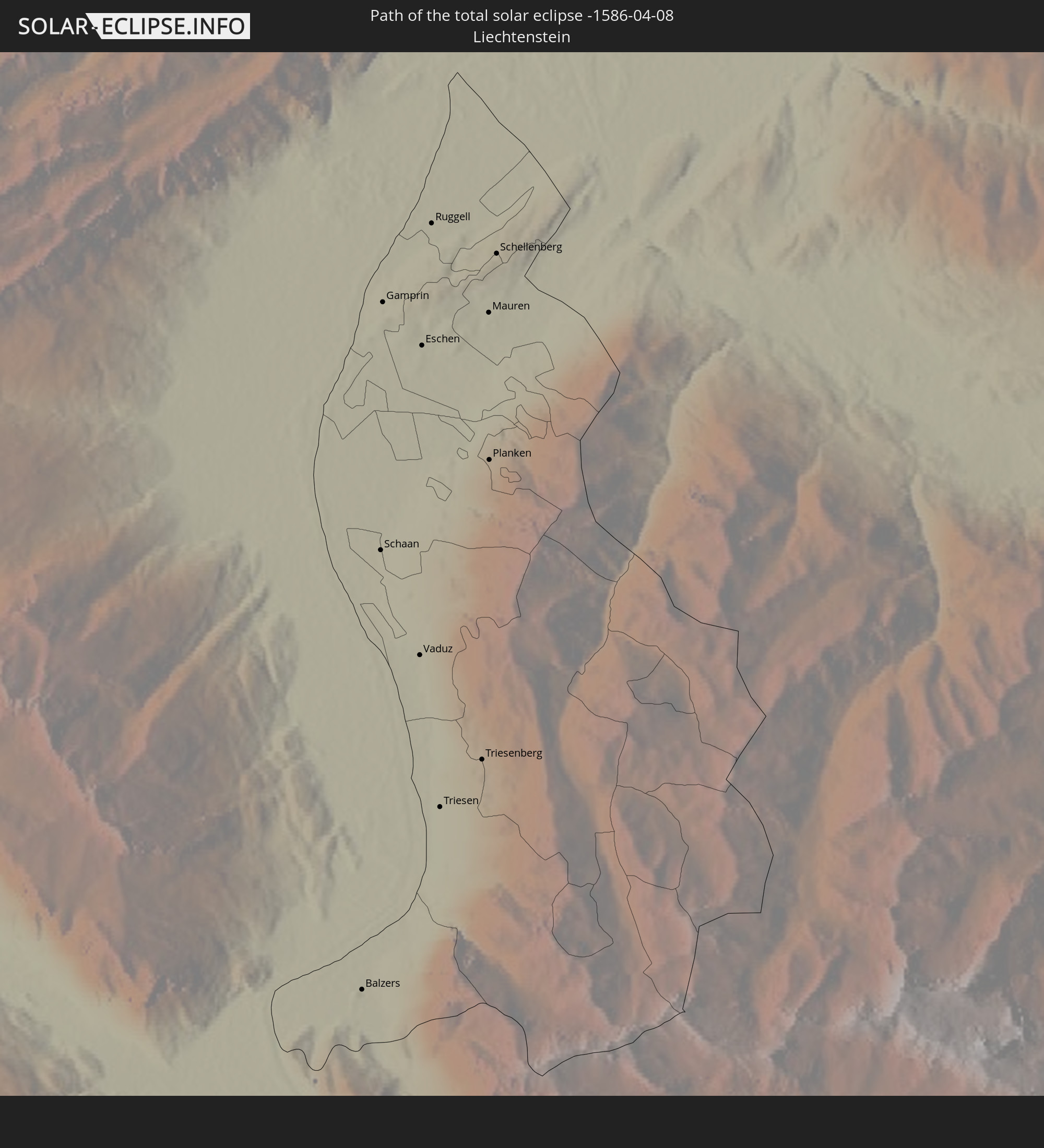
 Liechtenstein
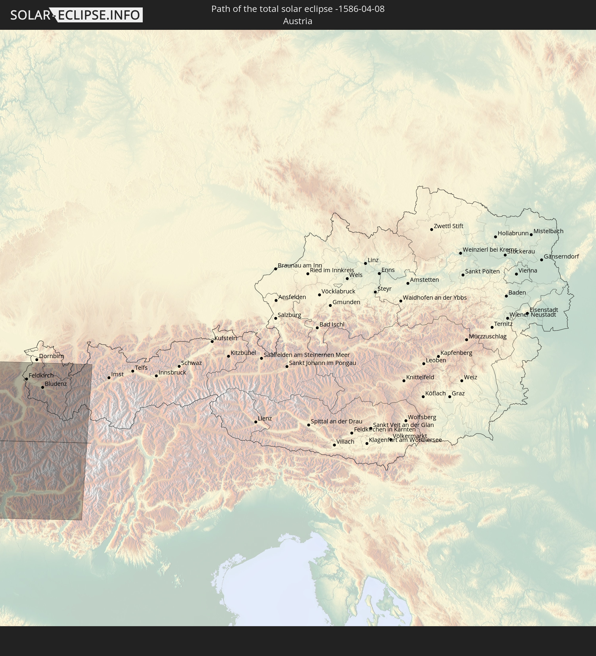
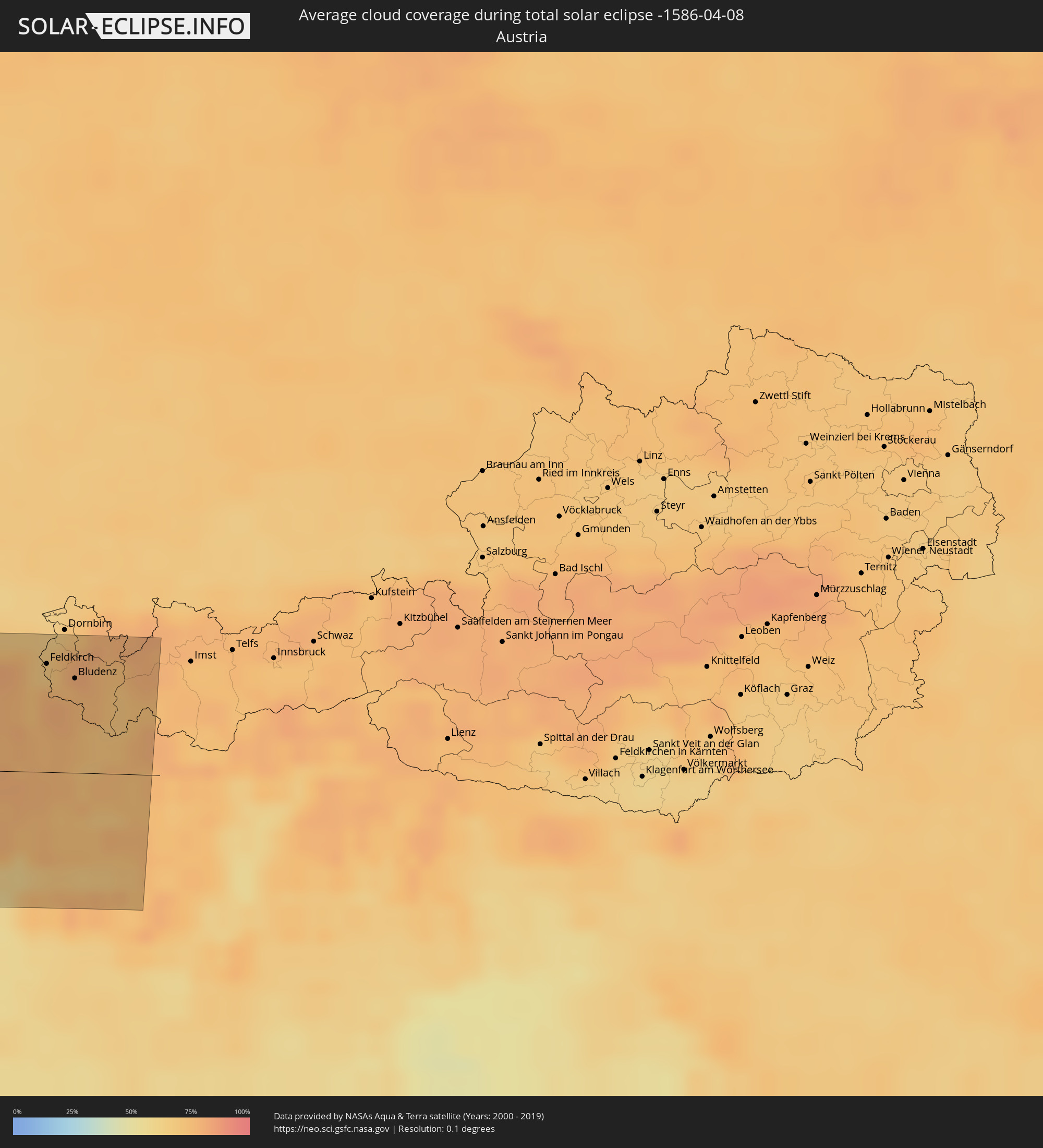 Austria
Cities inside the path of the eclipse
The following table shows all locations with a population of more than 5,000 inside the eclipse path. Cities which have more than 100,000 inhabitants are marked bold. A click at the locations opens a detailed map.
| City | Type | Eclipse duration | Local time of max. eclipse | Distance to central line | Ø Cloud coverage |
|
Manta, Manabí
|
total | - | 09:36:01 UTC-05:14 | 45 km | 90% |
|
Montecristi, Manabí
|
total | - | 09:35:57 UTC-05:14 | 56 km | 90% |
|
Jipijapa, Manabí
|
total | - | 09:35:33 UTC-05:14 | 88 km | 88% |
|
Portoviejo, Manabí
|
total | - | 09:36:13 UTC-05:14 | 70 km | 91% |
|
Bahía de Caráquez, Manabí
|
total | - | 09:37:02 UTC-05:14 | 32 km | 83% |
|
Chone, Manabí
|
total | - | 09:37:19 UTC-05:14 | 63 km | 91% |
|
Esmeraldas, Esmeraldas
|
total | - | 09:40:52 UTC-05:14 | 52 km | 85% |
|
Rosa Zarate, Esmeraldas
|
total | - | 09:40:00 UTC-05:14 | 16 km | 94% |
|
Santo Domingo de los Colorados, Santo Domingo de los Tsáchilas
|
total | - | 09:39:23 UTC-05:14 | 87 km | 97% |
|
San Lorenzo de Esmeraldas, Esmeraldas
|
total | - | 09:42:38 UTC-05:14 | 22 km | 89% |
|
Otavalo, Imbabura
|
total | - | 09:41:34 UTC-05:14 | 109 km | 94% |
|
Atuntaqui, Imbabura
|
total | - | 09:41:48 UTC-05:14 | 104 km | 91% |
|
Ibarra, Imbabura
|
total | - | 09:41:58 UTC-05:14 | 109 km | 88% |
|
Tulcán, Carchi
|
total | - | 09:43:24 UTC-05:14 | 98 km | 94% |
|
Pasto, Nariño
|
total | - | 10:02:30 UTC-04:56 | 96 km | 95% |
|
Buenaventura, Valle del Cauca
|
total | - | 10:07:53 UTC-04:56 | 107 km | 92% |
|
Popayán, Cauca
|
total | - | 10:05:47 UTC-04:56 | 43 km | 91% |
|
Cali, Valle del Cauca
|
total | - | 10:07:49 UTC-04:56 | 33 km | 83% |
|
Palmira, Valle del Cauca
|
total | - | 10:08:21 UTC-04:56 | 25 km | 88% |
|
Pereira, Risaralda
|
total | - | 10:11:45 UTC-04:56 | 81 km | 91% |
|
Armenia, Quindío
|
total | - | 10:11:14 UTC-04:56 | 58 km | 90% |
|
Manizales, Caldas
|
total | - | 10:12:32 UTC-04:56 | 88 km | 91% |
|
Neiva, Huila
|
total | - | 10:08:44 UTC-04:56 | 103 km | 91% |
|
Ibagué, Tolima
|
total | - | 10:11:45 UTC-04:56 | 16 km | 90% |
|
Soacha, Cundinamarca
|
total | - | 10:13:37 UTC-04:56 | 52 km | 90% |
|
Bogotá, Bogota D.C.
|
total | - | 10:13:53 UTC-04:56 | 60 km | 91% |
|
Bucaramanga, Santander
|
total | - | 10:20:28 UTC-04:56 | 60 km | 87% |
|
Cúcuta, Norte de Santander
|
total | - | 10:23:02 UTC-04:56 | 69 km | 86% |
|
San Cristóbal, Táchira
|
total | - | 10:51:50 UTC-04:27 | 37 km | 90% |
|
El Vigía, Mérida
|
total | - | 10:54:31 UTC-04:27 | 54 km | 95% |
|
Mérida, Mérida
|
total | - | 10:55:17 UTC-04:27 | 11 km | 81% |
|
Mucumpiz, Mérida
|
total | - | 10:54:58 UTC-04:27 | 4 km | 91% |
|
Valera, Trujillo
|
total | - | 10:57:42 UTC-04:27 | 20 km | 92% |
|
Barinas, Barinas
|
total | - | 10:56:56 UTC-04:27 | 64 km | 90% |
|
Carora, Lara
|
total | - | 11:00:21 UTC-04:27 | 40 km | 78% |
|
Guanare, Portuguesa
|
total | - | 10:58:34 UTC-04:27 | 71 km | 90% |
|
Coro, Falcón
|
total | - | 11:03:36 UTC-04:27 | 96 km | 64% |
|
Barquisimeto, Lara
|
total | - | 11:01:21 UTC-04:27 | 28 km | 75% |
|
Acarigua, Portuguesa
|
total | - | 11:00:33 UTC-04:27 | 79 km | 87% |
|
Yaritagua, Yaracuy
|
total | - | 11:01:46 UTC-04:27 | 46 km | 83% |
 Sint Michiel Liber
|
total | - | 10:58:13 UTC-04:35 | 92 km | 79% |
|
Willemstad
|
total | - | 10:58:12 UTC-04:35 | 85 km | 75% |
|
San Felipe, Yaracuy
|
total | - | 11:02:57 UTC-04:27 | 59 km | 85% |
 Kralendijk, Bonaire
|
total | - | 10:59:26 UTC-04:35 | 32 km | 81% |
|
Puerto Cabello, Carabobo
|
total | - | 11:04:26 UTC-04:27 | 108 km | 82% |
|
The Bottom, Saba
|
total | - | 11:19:20 UTC-04:35 | 4 km | 48% |
|
West End Village, West End
|
total | - | 11:50:19 UTC-04:06 | 34 km | 59% |
|
Blowing Point Village, Blowing Point
|
total | - | 11:50:25 UTC-04:06 | 30 km | 59% |
|
Sandy Ground Village, Sandy Ground
|
total | - | 11:50:29 UTC-04:06 | 31 km | 59% |
|
South Hill Village, South Hill
|
total | - | 11:50:28 UTC-04:06 | 31 km | 59% |
|
Marigot
|
total | - | 11:50:14 UTC-04:06 | 22 km | 62% |
|
North Hill Village, North Hill
|
total | - | 11:50:30 UTC-04:06 | 31 km | 59% |
|
George Hill, George Hill
|
total | - | 11:50:31 UTC-04:06 | 29 km | 59% |
 Cul de Sac
|
total | - | 11:20:29 UTC-04:35 | 18 km | 52% |
|
The Valley, The Valley
|
total | - | 11:50:34 UTC-04:06 | 30 km | 59% |
|
Stoney Ground, Stoney Ground
|
total | - | 11:50:36 UTC-04:06 | 29 km | 53% |
|
Philipsburg
|
total | - | 11:20:29 UTC-04:35 | 16 km | 53% |
|
North Side, North Side
|
total | - | 11:50:37 UTC-04:06 | 30 km | 53% |
|
The Quarter, The Quarter
|
total | - | 11:50:35 UTC-04:06 | 28 km | 53% |
|
Farrington, The Farrington
|
total | - | 11:50:37 UTC-04:06 | 27 km | 53% |
|
Sandy Hill, Sandy Hill
|
total | - | 11:50:39 UTC-04:06 | 27 km | 53% |
|
Island Harbour, Island Harbour
|
total | - | 11:50:44 UTC-04:06 | 29 km | 54% |
|
East End Village, East End
|
total | - | 11:50:42 UTC-04:06 | 26 km | 53% |
|
Oranjestad, Sint Eustatius
|
total | - | 11:19:30 UTC-04:35 | 28 km | 57% |
|
Gustavia
|
total | - | 11:50:17 UTC-04:06 | 10 km | 48% |
|
Sandy Point Town, Saint Anne Sandy Point
|
total | - | 11:49:12 UTC-04:06 | 48 km | 61% |
|
Saint Paul’s, Saint Paul Capesterre
|
total | - | 11:49:21 UTC-04:06 | 48 km | 61% |
|
Middle Island, Saint Thomas Middle Island
|
total | - | 11:49:11 UTC-04:06 | 53 km | 55% |
|
Dieppe Bay Town, Saint John Capesterre
|
total | - | 11:49:23 UTC-04:06 | 47 km | 61% |
|
Trinity, Trinity Palmetto Point
|
total | - | 11:49:14 UTC-04:06 | 59 km | 55% |
|
Nicola Town, Christ Church Nichola Town
|
total | - | 11:49:24 UTC-04:06 | 55 km | 61% |
|
Cayon, Saint Mary Cayon
|
total | - | 11:49:23 UTC-04:06 | 58 km | 55% |
|
Basseterre, Saint George Basseterre
|
total | - | 11:49:17 UTC-04:06 | 62 km | 58% |
|
Monkey Hill, Saint Peter Basseterre
|
total | - | 11:49:21 UTC-04:06 | 62 km | 58% |
|
Cotton Ground, Saint Thomas Lowland
|
total | - | 11:49:13 UTC-04:06 | 80 km | 57% |
|
Charlestown, Saint Paul Charlestown
|
total | - | 11:49:09 UTC-04:06 | 83 km | 50% |
|
Fig Tree, Saint John Figtree
|
total | - | 11:49:09 UTC-04:06 | 85 km | 50% |
|
Newcastle, Saint James Windwa
|
total | - | 11:49:21 UTC-04:06 | 81 km | 57% |
|
Market Shop, Saint George Gingerland
|
total | - | 11:49:12 UTC-04:06 | 88 km | 50% |
|
La Roche-sur-Yon, Pays de la Loire
|
total | - | 17:36:51 UTC+00:09 | 25 km | 65% |
|
La Rochelle, Nouvelle-Aquitaine
|
total | - | 17:37:09 UTC+00:09 | 32 km | 54% |
|
Cholet, Pays de la Loire
|
total | - | 17:36:46 UTC+00:09 | 66 km | 65% |
|
Niort, Nouvelle-Aquitaine
|
total | - | 17:37:14 UTC+00:09 | 19 km | 65% |
|
Poitiers, Nouvelle-Aquitaine
|
total | - | 17:37:15 UTC+00:09 | 6 km | 67% |
|
Limoges, Nouvelle-Aquitaine
|
total | - | 17:37:48 UTC+00:09 | 82 km | 62% |
|
Châteauroux, Centre
|
total | - | 17:37:23 UTC+00:09 | 26 km | 62% |
|
Bourges, Centre
|
total | - | 17:37:21 UTC+00:09 | 53 km | 64% |
|
Montluçon, Auvergne-Rhône-Alpes
|
total | - | 17:37:46 UTC+00:09 | 31 km | 60% |
|
Nevers, Bourgogne-Franche-Comté
|
total | - | 17:37:30 UTC+00:09 | 41 km | 60% |
|
Chalon-sur-Saône, Bourgogne-Franche-Comté
|
total | - | 17:37:48 UTC+00:09 | 14 km | 59% |
|
Dijon, Bourgogne-Franche-Comté
|
total | - | 17:37:32 UTC+00:09 | 73 km | 60% |
|
Bourg-en-Bresse, Auvergne-Rhône-Alpes
|
total | - | 17:38:09 UTC+00:09 | 51 km | 62% |
|
Besançon, Bourgogne-Franche-Comté
|
total | - | 17:37:39 UTC+00:09 | 65 km | 62% |
|
Genève, Geneva
|
total | - | 18:28:52 UTC+01:00 | 52 km | 60% |
|
Lausanne, Vaud
|
total | - | 18:28:45 UTC+01:00 | 17 km | 55% |
|
Yverdon-les-Bains, Vaud
|
total | - | 18:28:36 UTC+01:00 | 12 km | 61% |
|
La Chaux-de-Fonds, Neuchâtel
|
total | - | 18:28:26 UTC+01:00 | 48 km | 71% |
|
Fribourg, Fribourg
|
total | - | 18:28:37 UTC+01:00 | 15 km | 68% |
|
Biel/Bienne, Bern
|
total | - | 18:28:26 UTC+01:00 | 52 km | 59% |
|
Sitten, Valais
|
total | - | 18:28:56 UTC+01:00 | 49 km | 70% |
|
Bern, Bern
|
total | - | 18:28:33 UTC+01:00 | 31 km | 64% |
|
Thun, Bern
|
total | - | 18:28:40 UTC+01:00 | 9 km | 65% |
|
Villadossola, Piedmont
|
total | - | 18:29:03 UTC+01:00 | 66 km | 64% |
|
Domodossola, Piedmont
|
total | - | 18:29:02 UTC+01:00 | 61 km | 64% |
|
Luzern, Lucerne
|
total | - | 18:28:32 UTC+01:00 | 43 km | 66% |
|
Gravellona Toce, Piedmont
|
total | - | 18:29:08 UTC+01:00 | 82 km | 60% |
|
Zürich, Zurich
|
total | - | 18:28:21 UTC+01:00 | 78 km | 61% |
|
Verbania, Piedmont
|
total | - | 18:29:09 UTC+01:00 | 83 km | 53% |
|
Pallanza-Intra-Suna, Piedmont
|
total | - | 18:29:08 UTC+01:00 | 81 km | 53% |
|
Luino, Lombardy
|
total | - | 18:29:06 UTC+01:00 | 73 km | 55% |
|
Rapperswil, Saint Gallen
|
total | - | 18:28:26 UTC+01:00 | 63 km | 69% |
|
Lavena Ponte Tresa, Lombardy
|
total | - | 18:29:08 UTC+01:00 | 77 km | 54% |
|
Lugano, Ticino
|
total | - | 18:29:06 UTC+01:00 | 72 km | 56% |
|
Mandello del Lario, Lombardy
|
total | - | 18:29:09 UTC+01:00 | 81 km | 55% |
|
Colico Piano, Lombardy
|
total | - | 18:29:03 UTC+01:00 | 58 km | 68% |
|
Chiavenna, Lombardy
|
total | - | 18:28:57 UTC+01:00 | 37 km | 65% |
|
Balzers, Balzers
|
total | - | 18:28:32 UTC+01:00 | 46 km | 73% |
|
Schaan, Schaan
|
total | - | 18:28:29 UTC+01:00 | 57 km | 73% |
|
Gamprin, Gamprin
|
total | - | 18:28:27 UTC+01:00 | 63 km | 73% |
|
Vaduz, Vaduz
|
total | - | 18:28:30 UTC+01:00 | 55 km | 73% |
|
Eschen, Eschen
|
total | - | 18:28:27 UTC+01:00 | 62 km | 73% |
|
Ruggell, Ruggell
|
total | - | 18:28:27 UTC+01:00 | 65 km | 73% |
|
Triesen, Triesen
|
total | - | 18:28:31 UTC+01:00 | 51 km | 73% |
|
Chur, Grisons
|
total | - | 18:28:40 UTC+01:00 | 22 km | 77% |
|
Triesenberg, Triesenberg
|
total | - | 18:28:31 UTC+01:00 | 52 km | 73% |
|
Mauren, Mauren
|
total | - | 18:28:27 UTC+01:00 | 63 km | 73% |
|
Planken, Planken
|
total | - | 18:28:28 UTC+01:00 | 60 km | 73% |
|
Schellenberg, Schellenberg
|
total | - | 18:28:27 UTC+01:00 | 65 km | 73% |
|
Cosio Valtellino, Lombardy
|
total | - | 18:29:03 UTC+01:00 | 57 km | 74% |
|
Morbegno, Lombardy
|
total | - | 18:29:03 UTC+01:00 | 57 km | 74% |
|
Feldkirch, Vorarlberg
|
total | - | 18:28:27 UTC+01:00 | 65 km | 76% |
|
Götzis, Vorarlberg
|
total | - | 18:28:23 UTC+01:00 | 76 km | 67% |
|
Rankweil, Vorarlberg
|
total | - | 18:28:25 UTC+01:00 | 69 km | 67% |
|
Altach, Vorarlberg
|
total | - | 18:28:23 UTC+01:00 | 78 km | 72% |
|
Hohenems, Vorarlberg
|
total | - | 18:28:22 UTC+01:00 | 80 km | 72% |
|
Nenzing, Vorarlberg
|
total | - | 18:28:28 UTC+01:00 | 60 km | 75% |
|
Bludenz, Vorarlberg
|
total | - | 18:28:29 UTC+01:00 | 57 km | 75% |
|
Sondrio, Lombardy
|
total | - | 18:29:02 UTC+01:00 | 53 km | 67% |
|
Tirano, Lombardy
|
total | - | 18:29:00 UTC+01:00 | 47 km | 71% |