Hybrid solar eclipse of 11/22/-1626
| Day of week: | Thursday |
| Maximum duration of eclipse: | 00m43s |
| Maximum width of eclipse path: | 35 km |
| Saros cycle: | 26 |
| Coverage: | 100% |
| Magnitude: | 1.0089 |
| Gamma: | -0.4691 |
Wo kann man die Sonnenfinsternis vom 11/22/-1626 sehen?
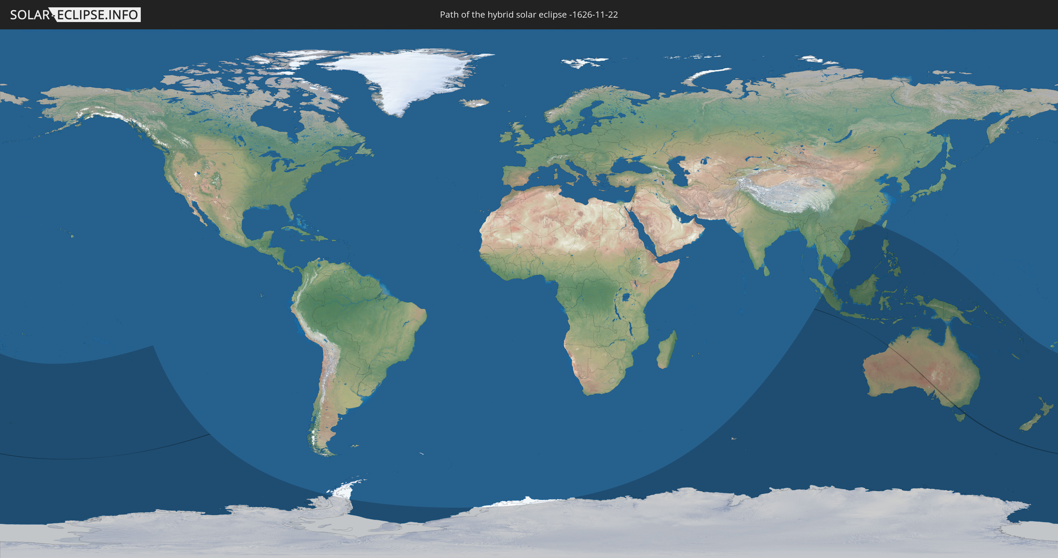
Die Sonnenfinsternis am 11/22/-1626 kann man in 31 Ländern als partielle Sonnenfinsternis beobachten.
Der Finsternispfad verläuft durch 2 Länder. Nur in diesen Ländern ist sie als hybrid Sonnenfinsternis zu sehen.
In den folgenden Ländern ist die Sonnenfinsternis hybrid zu sehen
 New Zealand
 Australia
In den folgenden Ländern ist die Sonnenfinsternis partiell zu sehen
 Antarctica
 Fiji
Fiji
 New Zealand
 Tonga
Tonga
 French Polynesia
 Pitcairn Islands
 French Southern and Antarctic Lands
 Heard Island and McDonald Islands
 China
China
 Indonesia
 Cocos Islands
 Malaysia
 Laos
Laos
 Vietnam
 Cambodia
 Singapore
 Christmas Island
 Australia
 Macau
Macau
 Hong Kong
 Brunei
 Taiwan
 Philippines
 East Timor
 Palau
Palau
 Federated States of Micronesia
 Papua New Guinea
 Solomon Islands
 New Caledonia
 Vanuatu
 Norfolk Island
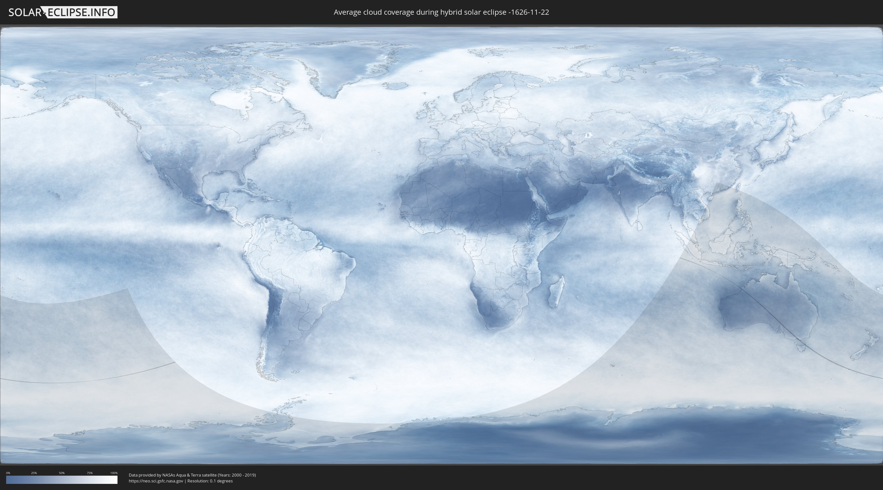
How will be the weather during the hybrid solar eclipse on 11/22/-1626?
Where is the best place to see the hybrid solar eclipse of 11/22/-1626?
The following maps show the average cloud coverage for the day of the hybrid solar eclipse.
With the help of these maps, it is possible to find the place along the eclipse path, which has the best
chance of a cloudless sky.
Nevertheless, you should consider local circumstances and inform about the weather of your chosen
observation site.
The data is provided by NASAs satellites
AQUA and TERRA.
The cloud maps are averaged over a period of 19 years (2000 - 2019).

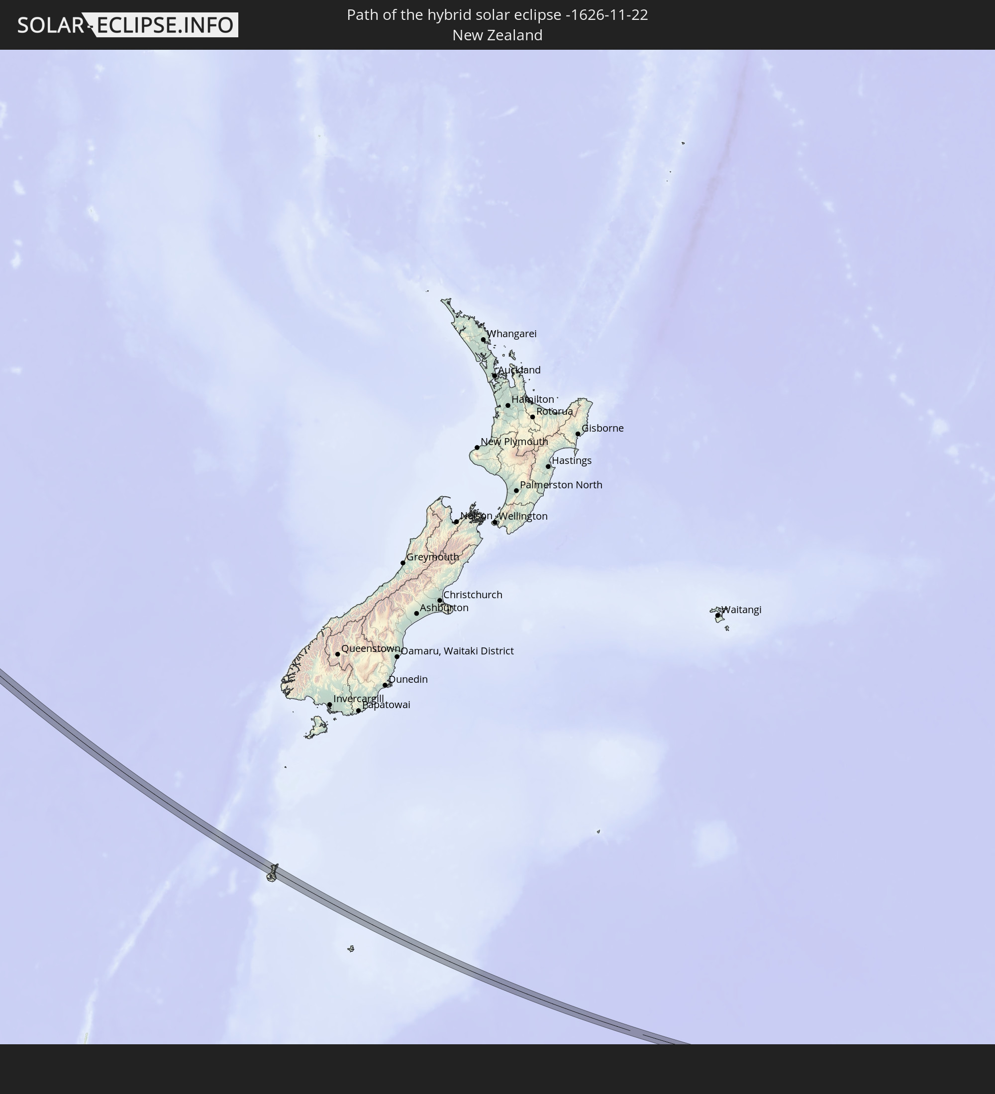
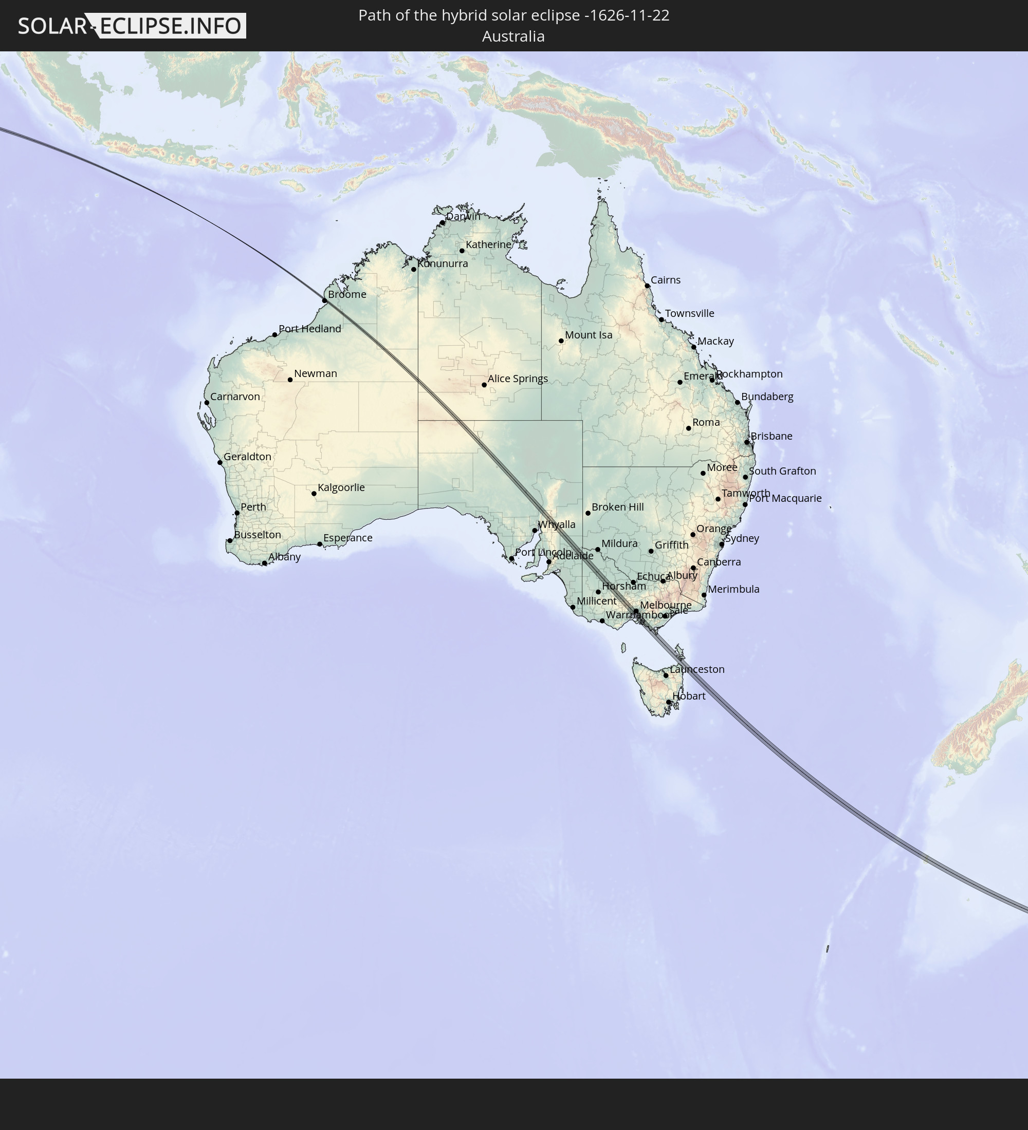
Detailed country maps
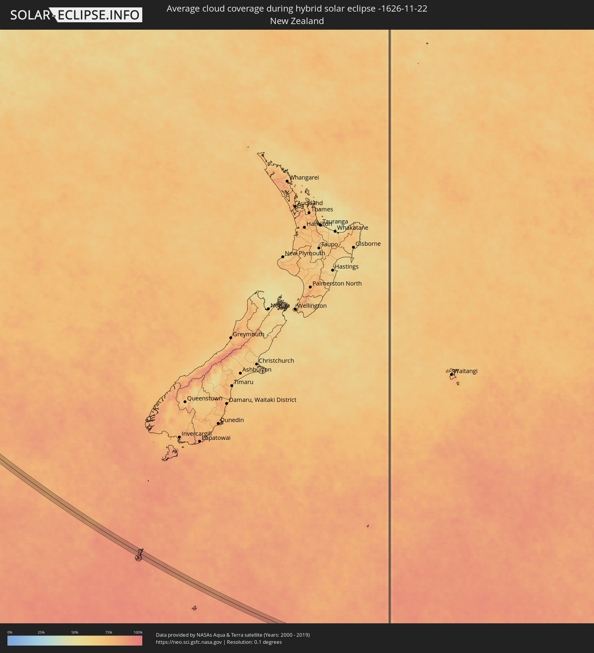 New Zealand
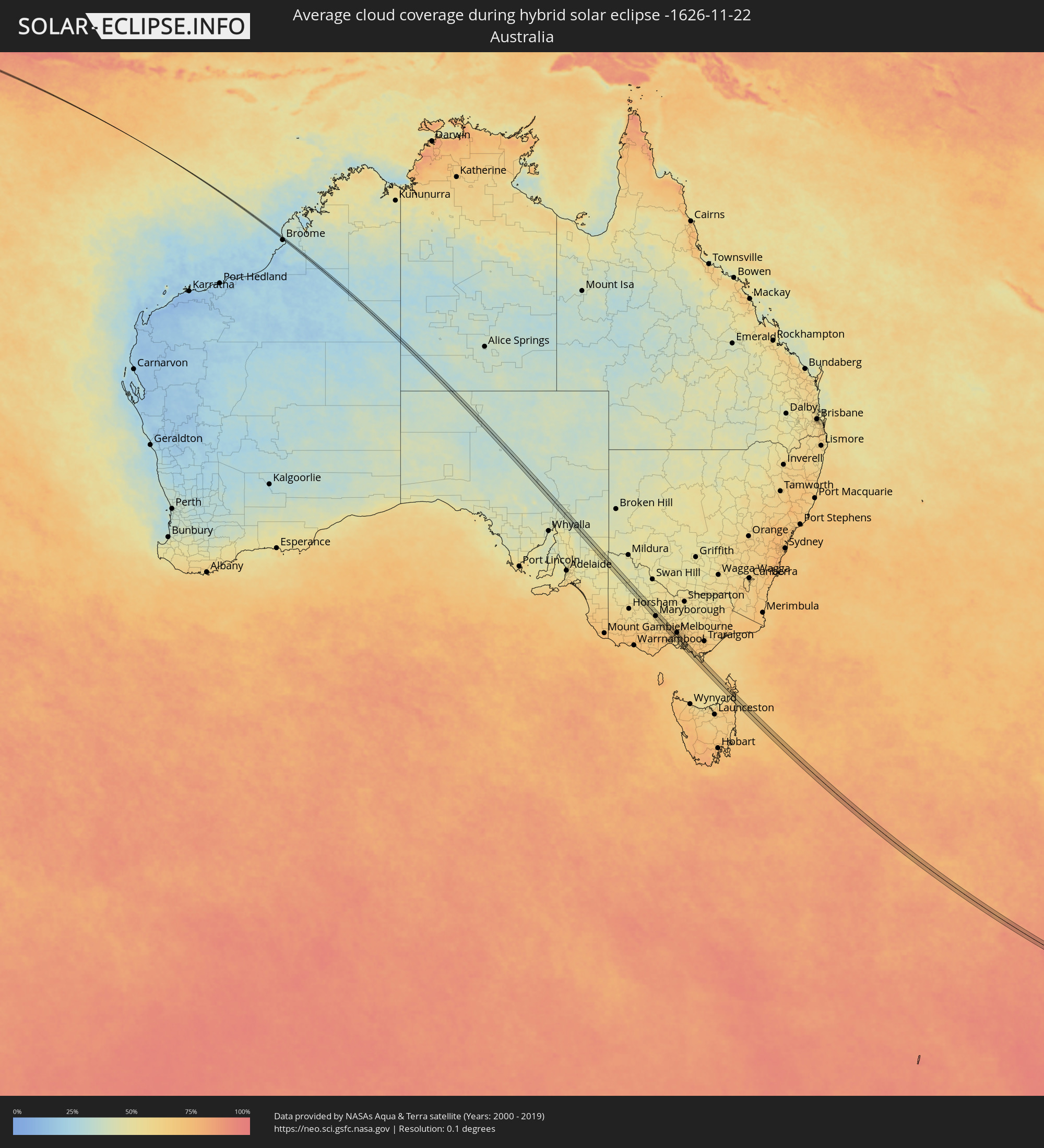 Australia
Cities inside the path of the eclipse
The following table shows all locations with a population of more than 5,000 inside the eclipse path. Cities which have more than 100,000 inhabitants are marked bold. A click at the locations opens a detailed map.
| City | Type | Eclipse duration | Local time of max. eclipse | Distance to central line | Ø Cloud coverage |
|
Maryborough, Victoria
|
total | - | 10:31:29 UTC+10:00 | 5 km | 57% |
|
Bacchus Marsh, Victoria
|
total | - | 10:33:36 UTC+10:00 | 7 km | 67% |
|
Wyndham Vale, Victoria
|
total | - | 10:34:04 UTC+10:00 | 13 km | 68% |
|
Melton West, Victoria
|
total | - | 10:33:48 UTC+10:00 | 1 km | 68% |
|
Melton South, Victoria
|
total | - | 10:33:51 UTC+10:00 | 0 km | 68% |
|
Melton, Victoria
|
total | - | 10:33:49 UTC+10:00 | 2 km | 68% |
|
Kurunjang, Victoria
|
total | - | 10:33:49 UTC+10:00 | 3 km | 68% |
|
Werribee, Victoria
|
total | - | 10:34:21 UTC+10:00 | 9 km | 66% |
|
Tarneit, Victoria
|
total | - | 10:34:17 UTC+10:00 | 7 km | 66% |
|
Hoppers Crossing, Victoria
|
total | - | 10:34:21 UTC+10:00 | 6 km | 66% |
|
Caroline Springs, Victoria
|
total | - | 10:34:08 UTC+10:00 | 7 km | 70% |
|
Hillside, Victoria
|
total | - | 10:34:03 UTC+10:00 | 12 km | 70% |
|
Truganina, Victoria
|
total | - | 10:34:18 UTC+10:00 | 3 km | 69% |
|
Point Cook, Victoria
|
total | - | 10:34:29 UTC+10:00 | 5 km | 64% |
|
Taylors Hill, Victoria
|
total | - | 10:34:06 UTC+10:00 | 11 km | 69% |
|
Sydenham, Victoria
|
total | - | 10:34:06 UTC+10:00 | 12 km | 69% |
|
Derrimut, Victoria
|
total | - | 10:34:17 UTC+10:00 | 6 km | 69% |
|
Delahey, Victoria
|
total | - | 10:34:09 UTC+10:00 | 12 km | 69% |
|
Deer Park, Victoria
|
total | - | 10:34:15 UTC+10:00 | 9 km | 69% |
|
Altona Meadows, Victoria
|
total | - | 10:34:28 UTC+10:00 | 1 km | 64% |
|
Taylors Lakes, Victoria
|
total | - | 10:34:07 UTC+10:00 | 14 km | 69% |
|
Cairnlea, Victoria
|
total | - | 10:34:14 UTC+10:00 | 9 km | 69% |
|
Saint Albans, Victoria
|
total | - | 10:34:12 UTC+10:00 | 12 km | 69% |
|
St Albans, Victoria
|
total | - | 10:34:14 UTC+10:00 | 11 km | 69% |
|
Keilor Downs, Victoria
|
total | - | 10:34:12 UTC+10:00 | 13 km | 69% |
|
Sunshine West, Victoria
|
total | - | 10:34:20 UTC+10:00 | 9 km | 69% |
|
Sunshine North, Victoria
|
total | - | 10:34:19 UTC+10:00 | 11 km | 69% |
|
Altona, Victoria
|
total | - | 10:34:30 UTC+10:00 | 4 km | 64% |
|
Keilor, Victoria
|
total | - | 10:34:13 UTC+10:00 | 16 km | 69% |
|
Altona North, Victoria
|
total | - | 10:34:28 UTC+10:00 | 7 km | 69% |
|
Braybrook, Victoria
|
total | - | 10:34:23 UTC+10:00 | 12 km | 67% |
|
Keilor East, Victoria
|
total | - | 10:34:18 UTC+10:00 | 16 km | 67% |
|
Maidstone, Victoria
|
total | - | 10:34:24 UTC+10:00 | 13 km | 67% |
|
West Footscray, Victoria
|
total | - | 10:34:26 UTC+10:00 | 12 km | 67% |
|
Maribyrnong, Victoria
|
total | - | 10:34:25 UTC+10:00 | 14 km | 67% |
|
Newport, Victoria
|
total | - | 10:34:32 UTC+10:00 | 9 km | 67% |
|
Williamstown, Victoria
|
total | - | 10:34:34 UTC+10:00 | 9 km | 63% |
|
Footscray, Victoria
|
total | - | 10:34:28 UTC+10:00 | 14 km | 67% |
|
Yarraville, Victoria
|
total | - | 10:34:30 UTC+10:00 | 12 km | 67% |
|
Essendon, Victoria
|
total | - | 10:34:26 UTC+10:00 | 17 km | 67% |
|
Moonee Ponds, Victoria
|
total | - | 10:34:26 UTC+10:00 | 17 km | 67% |
|
Ascot Vale, Victoria
|
total | - | 10:34:28 UTC+10:00 | 16 km | 67% |
|
Flemington, Victoria
|
total | - | 10:34:29 UTC+10:00 | 16 km | 67% |
|
Kensington, Victoria
|
total | - | 10:34:29 UTC+10:00 | 17 km | 67% |
|
Port Melbourne, Victoria
|
total | - | 10:34:36 UTC+10:00 | 13 km | 67% |
|
North Melbourne, Victoria
|
total | - | 10:34:32 UTC+10:00 | 16 km | 67% |
|
Docklands, Victoria
|
total | - | 10:34:34 UTC+10:00 | 16 km | 65% |
|
Melbourne, Victoria
|
total | - | 10:34:35 UTC+10:00 | 17 km | 65% |
|
Southbank, Victoria
|
total | - | 10:34:36 UTC+10:00 | 16 km | 65% |
|
South Melbourne, Victoria
|
total | - | 10:34:37 UTC+10:00 | 15 km | 65% |
|
Saint Kilda, Victoria
|
total | - | 10:34:42 UTC+10:00 | 14 km | 64% |
|
Elwood, Victoria
|
total | - | 10:34:44 UTC+10:00 | 13 km | 64% |
|
Windsor, Victoria
|
total | - | 10:34:42 UTC+10:00 | 15 km | 64% |
|
Balaclava, Victoria
|
total | - | 10:34:44 UTC+10:00 | 15 km | 64% |
|
Hampton, Victoria
|
total | - | 10:34:53 UTC+10:00 | 9 km | 62% |
|
Albert Park, Victoria
|
total | - | 10:34:40 UTC+10:00 | 17 km | 65% |
|
St Kilda East, Victoria
|
total | - | 10:34:44 UTC+10:00 | 15 km | 64% |
|
Elsternwick, Victoria
|
total | - | 10:34:46 UTC+10:00 | 14 km | 64% |
|
Black Rock, Victoria
|
total | - | 10:34:57 UTC+10:00 | 8 km | 62% |
|
Mount Martha, Victoria
|
total | - | 10:35:31 UTC+10:00 | 14 km | 61% |
|
Brighton East, Victoria
|
total | - | 10:34:49 UTC+10:00 | 13 km | 64% |
|
Caulfield North, Victoria
|
total | - | 10:34:46 UTC+10:00 | 16 km | 64% |
|
Caulfield North, Victoria
|
total | - | 10:34:47 UTC+10:00 | 16 km | 64% |
|
Caulfield South, Victoria
|
total | - | 10:34:49 UTC+10:00 | 14 km | 64% |
|
Ormond, Victoria
|
total | - | 10:34:50 UTC+10:00 | 15 km | 64% |
|
Beaumaris, Victoria
|
total | - | 10:35:00 UTC+10:00 | 8 km | 62% |
|
Moorabbin, Victoria
|
total | - | 10:34:55 UTC+10:00 | 12 km | 64% |
|
Bentleigh, Victoria
|
total | - | 10:34:53 UTC+10:00 | 13 km | 64% |
|
Mornington, Victoria
|
total | - | 10:35:27 UTC+10:00 | 9 km | 60% |
|
Malvern East, Victoria
|
total | - | 10:34:48 UTC+10:00 | 17 km | 64% |
|
Cheltenham, Victoria
|
total | - | 10:34:59 UTC+10:00 | 10 km | 62% |
|
McKinnon, Victoria
|
total | - | 10:34:54 UTC+10:00 | 14 km | 65% |
|
Highett, Victoria
|
total | - | 10:34:57 UTC+10:00 | 12 km | 65% |
|
Mentone, Victoria
|
total | - | 10:35:02 UTC+10:00 | 10 km | 65% |
|
Parkdale, Victoria
|
total | - | 10:35:02 UTC+10:00 | 10 km | 65% |
|
Murrumbeena, Victoria
|
total | - | 10:34:53 UTC+10:00 | 17 km | 65% |
|
Mount Eliza, Victoria
|
total | - | 10:35:27 UTC+10:00 | 4 km | 60% |
|
Mordialloc, Victoria
|
total | - | 10:35:06 UTC+10:00 | 10 km | 65% |
|
Oakleigh South, Victoria
|
total | - | 10:34:58 UTC+10:00 | 16 km | 65% |
|
Aspendale, Victoria
|
total | - | 10:35:11 UTC+10:00 | 9 km | 65% |
|
Edithvale, Victoria
|
total | - | 10:35:12 UTC+10:00 | 9 km | 65% |
|
Clayton South, Victoria
|
total | - | 10:35:01 UTC+10:00 | 17 km | 65% |
|
Clarinda, Victoria
|
total | - | 10:35:01 UTC+10:00 | 17 km | 65% |
|
Chelsea, Victoria
|
total | - | 10:35:14 UTC+10:00 | 8 km | 63% |
|
Aspendale Gardens, Victoria
|
total | - | 10:35:11 UTC+10:00 | 11 km | 65% |
|
Bonbeach, Victoria
|
total | - | 10:35:16 UTC+10:00 | 8 km | 63% |
|
Frankston, Victoria
|
total | - | 10:35:25 UTC+10:00 | 2 km | 63% |
|
Seaford, Victoria
|
total | - | 10:35:21 UTC+10:00 | 6 km | 63% |
|
Frankston East, Victoria
|
total | - | 10:35:25 UTC+10:00 | 3 km | 63% |
|
Chelsea Heights, Victoria
|
total | - | 10:35:14 UTC+10:00 | 11 km | 65% |
|
Dingley Village, Victoria
|
total | - | 10:35:08 UTC+10:00 | 15 km | 65% |
|
Frankston South, Victoria
|
total | - | 10:35:29 UTC+10:00 | 1 km | 60% |
|
Patterson Lakes, Victoria
|
total | - | 10:35:19 UTC+10:00 | 9 km | 63% |
|
Frankston North, Victoria
|
total | - | 10:35:25 UTC+10:00 | 5 km | 63% |
|
Springvale South, Victoria
|
total | - | 10:35:07 UTC+10:00 | 17 km | 69% |
|
Langwarrin, Victoria
|
total | - | 10:35:31 UTC+10:00 | 3 km | 63% |
|
Somerville, Victoria
|
total | - | 10:35:37 UTC+10:00 | 1 km | 63% |
|
Carrum Downs, Victoria
|
total | - | 10:35:24 UTC+10:00 | 8 km | 64% |
|
Keysborough, Victoria
|
total | - | 10:35:12 UTC+10:00 | 17 km | 69% |
|
Hastings, Victoria
|
total | - | 10:35:48 UTC+10:00 | 6 km | 62% |
|
Skye, Victoria
|
total | - | 10:35:28 UTC+10:00 | 11 km | 64% |
|
Phillip Island, Victoria
|
total | - | 10:36:13 UTC+10:00 | 17 km | 62% |
|
Lynbrook, Victoria
|
total | - | 10:35:26 UTC+10:00 | 17 km | 66% |
|
Cranbourne West, Victoria
|
total | - | 10:35:32 UTC+10:00 | 15 km | 66% |
|
Cranbourne North, Victoria
|
total | - | 10:35:31 UTC+10:00 | 16 km | 66% |
|
Cranbourne, Victoria
|
total | - | 10:35:35 UTC+10:00 | 14 km | 66% |
|
Cranbourne, Victoria
|
total | - | 10:35:33 UTC+10:00 | 15 km | 66% |
|
Cranbourne East, Victoria
|
total | - | 10:35:36 UTC+10:00 | 15 km | 66% |
|
North Wonthaggi, Victoria
|
total | - | 10:36:56 UTC+10:00 | 3 km | 63% |