Annular solar eclipse of 11/30/-1841
| Day of week: | Wednesday |
| Maximum duration of eclipse: | 08m08s |
| Maximum width of eclipse path: | 459 km |
| Saros cycle: | 3 |
| Coverage: | 91.3% |
| Magnitude: | 0.9127 |
| Gamma: | -0.6864 |
Wo kann man die Sonnenfinsternis vom 11/30/-1841 sehen?
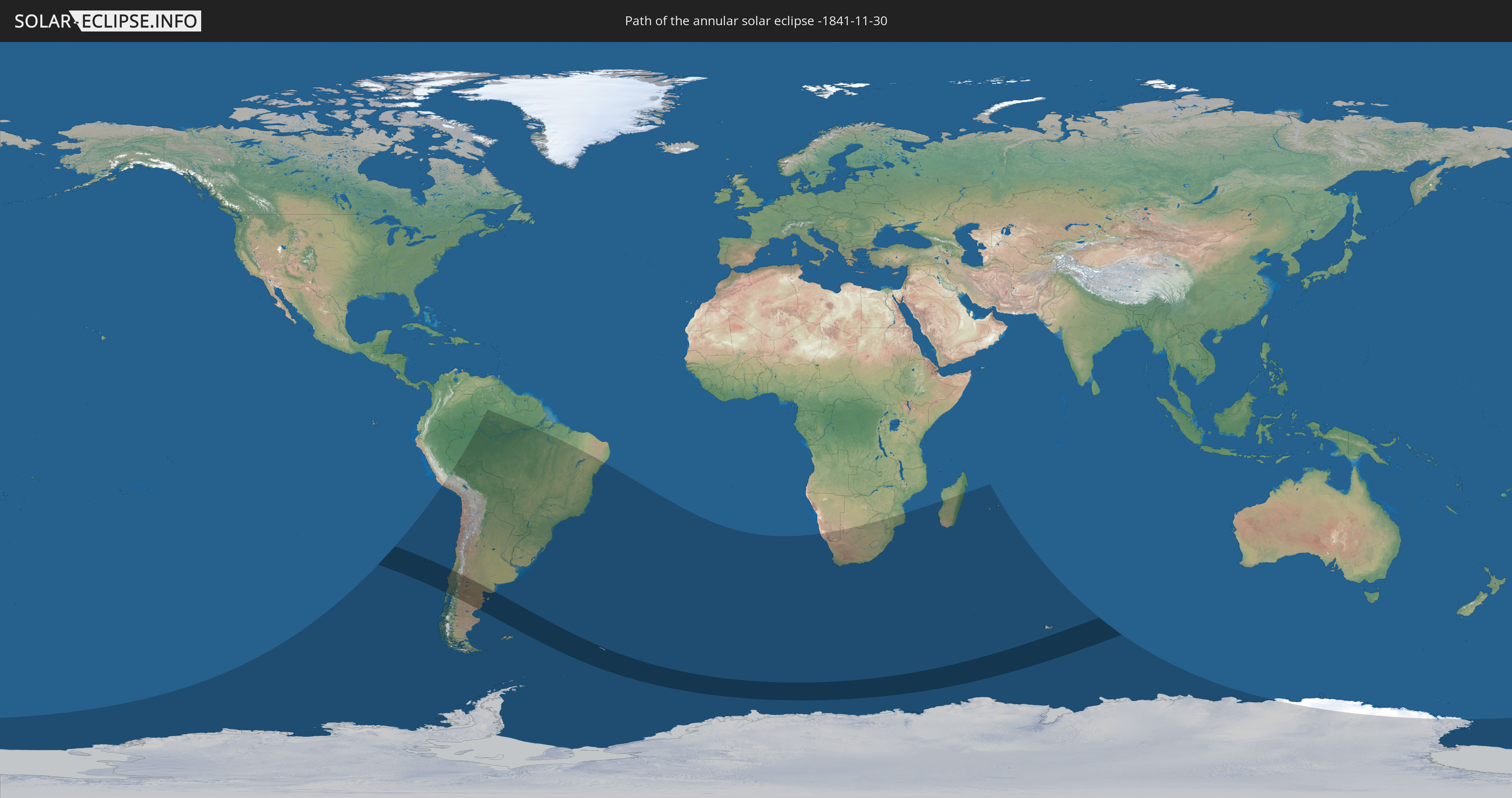
Die Sonnenfinsternis am 11/30/-1841 kann man in 24 Ländern als partielle Sonnenfinsternis beobachten.
Der Finsternispfad verläuft durch 4 Länder. Nur in diesen Ländern ist sie als annular Sonnenfinsternis zu sehen.
In den folgenden Ländern ist die Sonnenfinsternis annular zu sehen
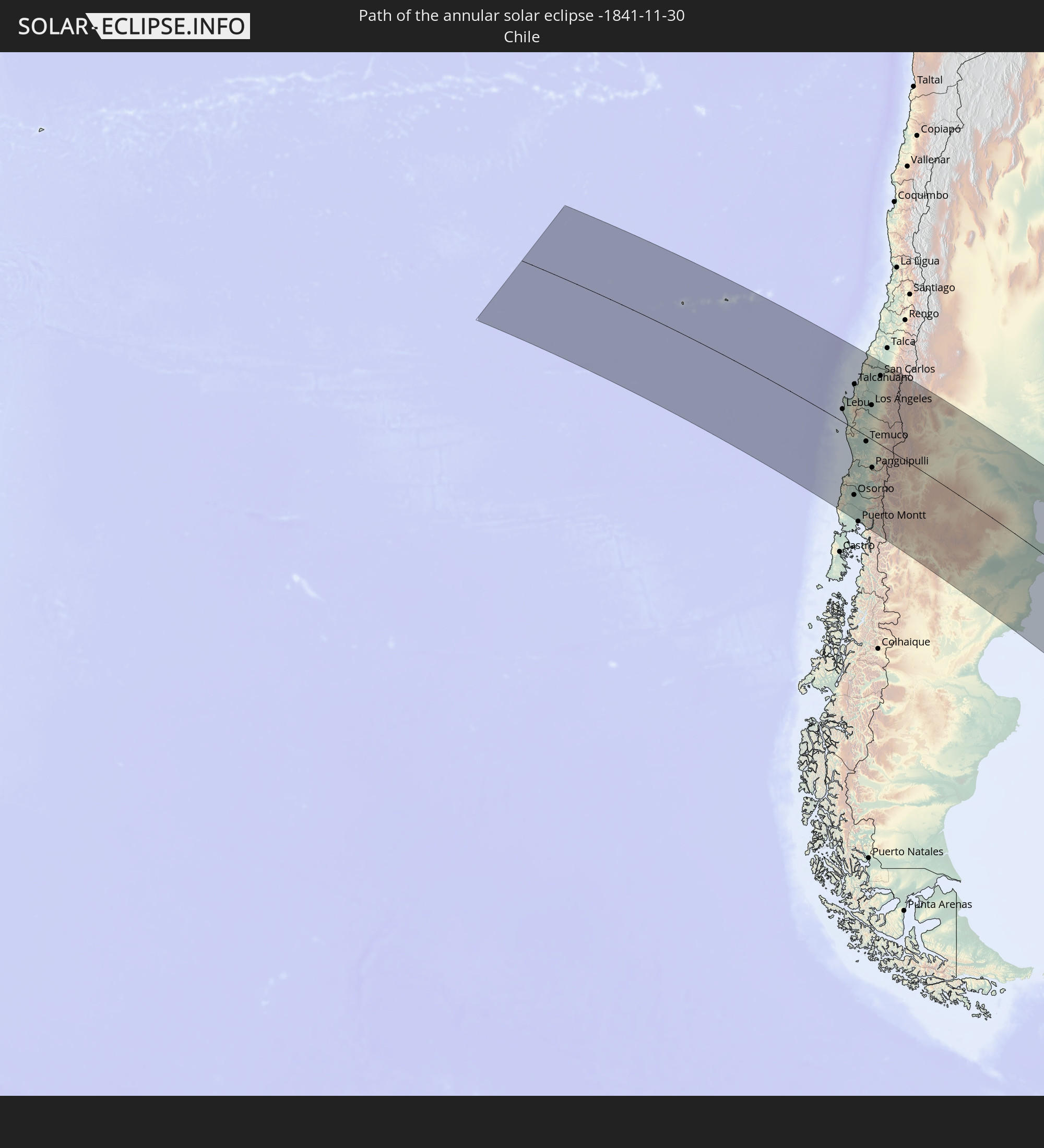 Chile
Chile
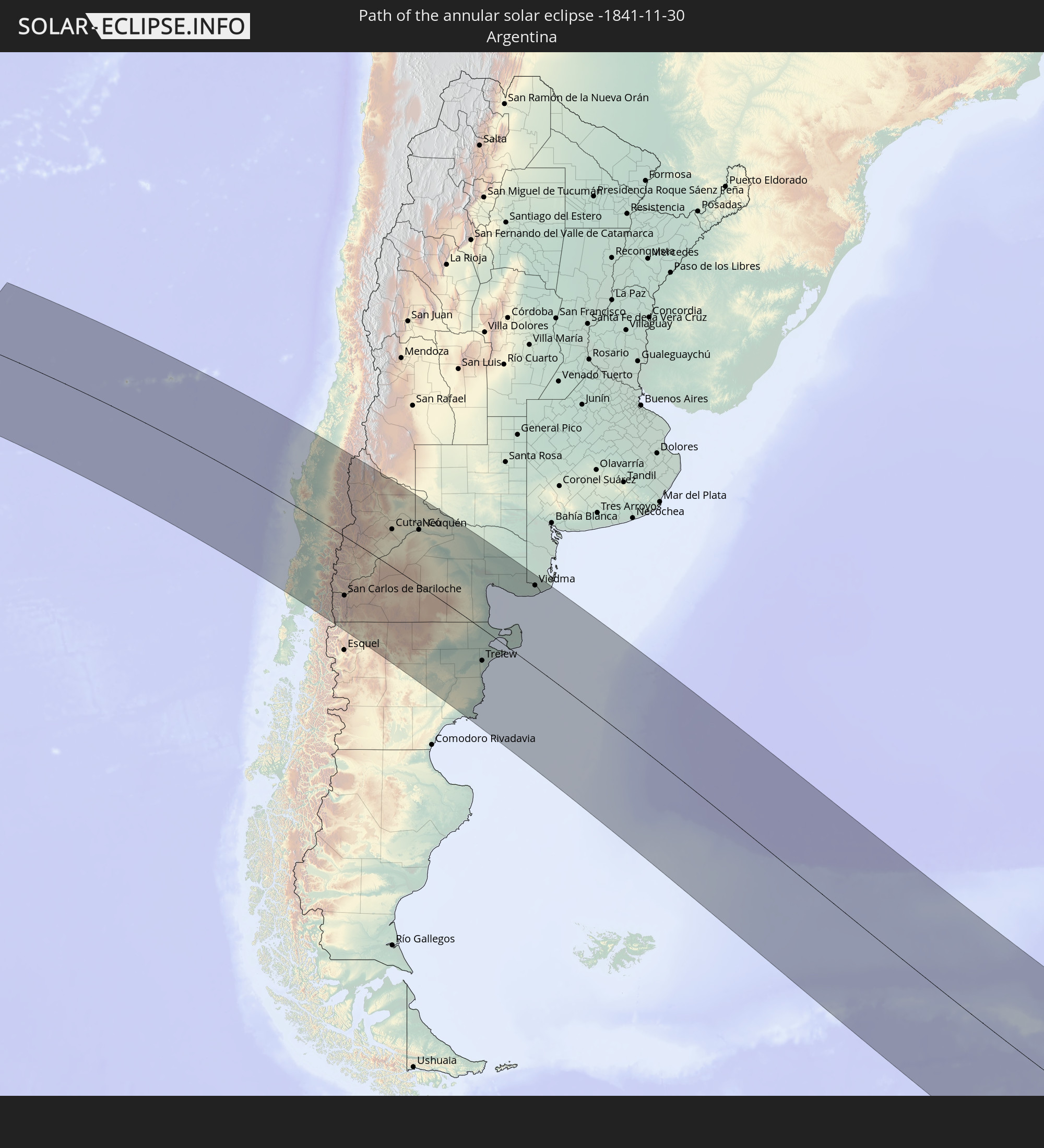 Argentina
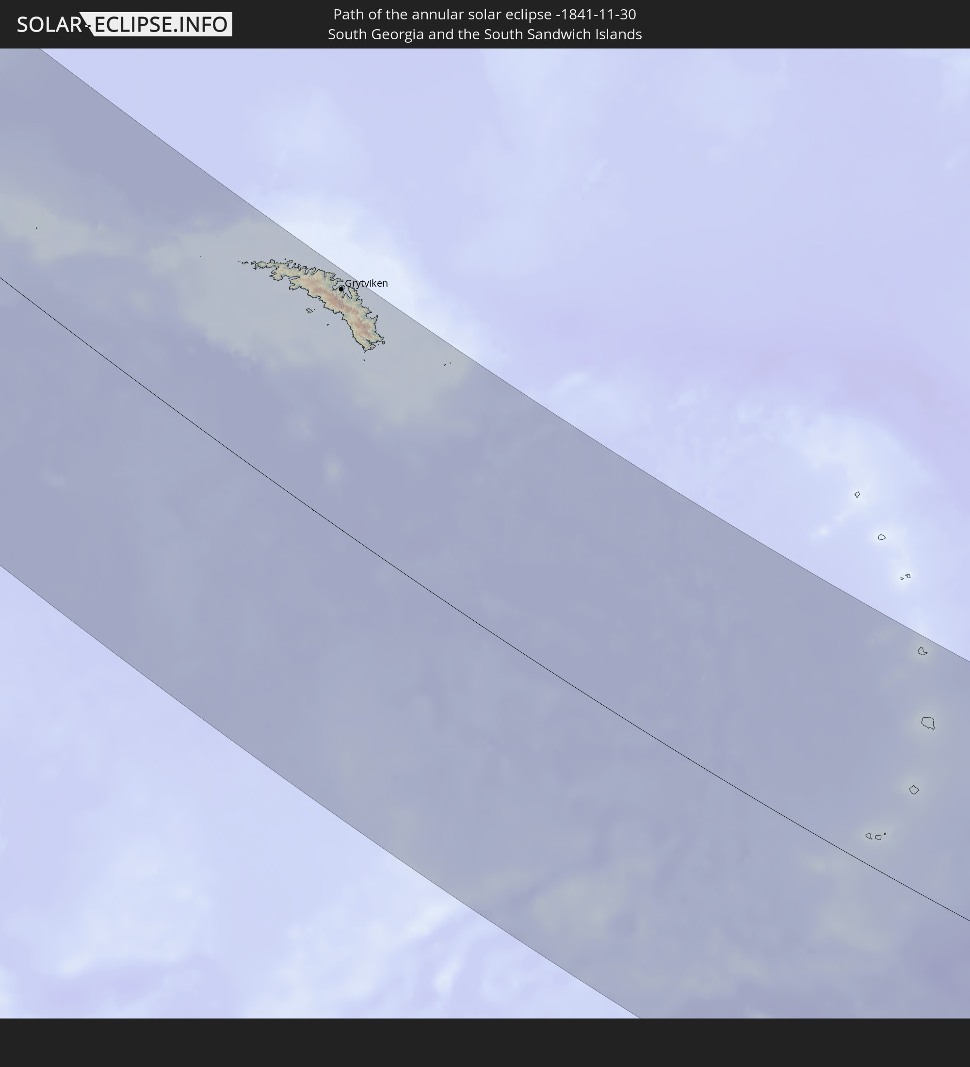 South Georgia and the South Sandwich Islands
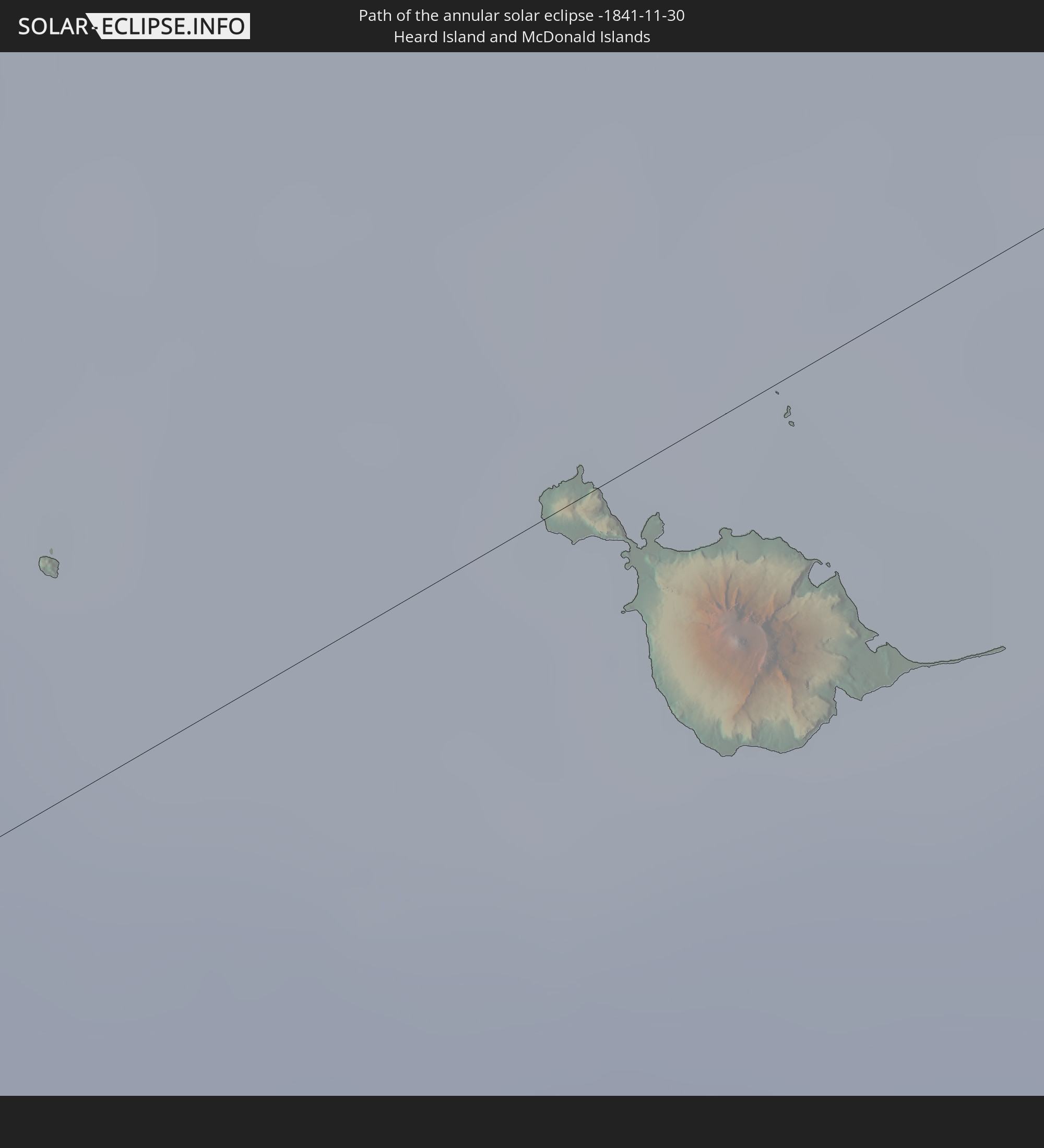 Heard Island and McDonald Islands
In den folgenden Ländern ist die Sonnenfinsternis partiell zu sehen
 Antarctica
 Chile
Chile
 Peru
Peru
 Brazil
 Argentina
 Venezuela
 Bolivia
 Paraguay
 Falkland Islands
 Uruguay
 South Georgia and the South Sandwich Islands
 Saint Helena, Ascension and Tristan da Cunha
 Bouvet Island
 Namibia
 South Africa
 Botswana
 Lesotho
 Mozambique
 Swaziland
 French Southern and Antarctic Lands
 Madagascar
 Réunion
 Mauritius
 Heard Island and McDonald Islands
How will be the weather during the annular solar eclipse on 11/30/-1841?
Where is the best place to see the annular solar eclipse of 11/30/-1841?
The following maps show the average cloud coverage for the day of the annular solar eclipse.
With the help of these maps, it is possible to find the place along the eclipse path, which has the best
chance of a cloudless sky.
Nevertheless, you should consider local circumstances and inform about the weather of your chosen
observation site.
The data is provided by NASAs satellites
AQUA and TERRA.
The cloud maps are averaged over a period of 19 years (2000 - 2019).
Detailed country maps
 Chile
Chile
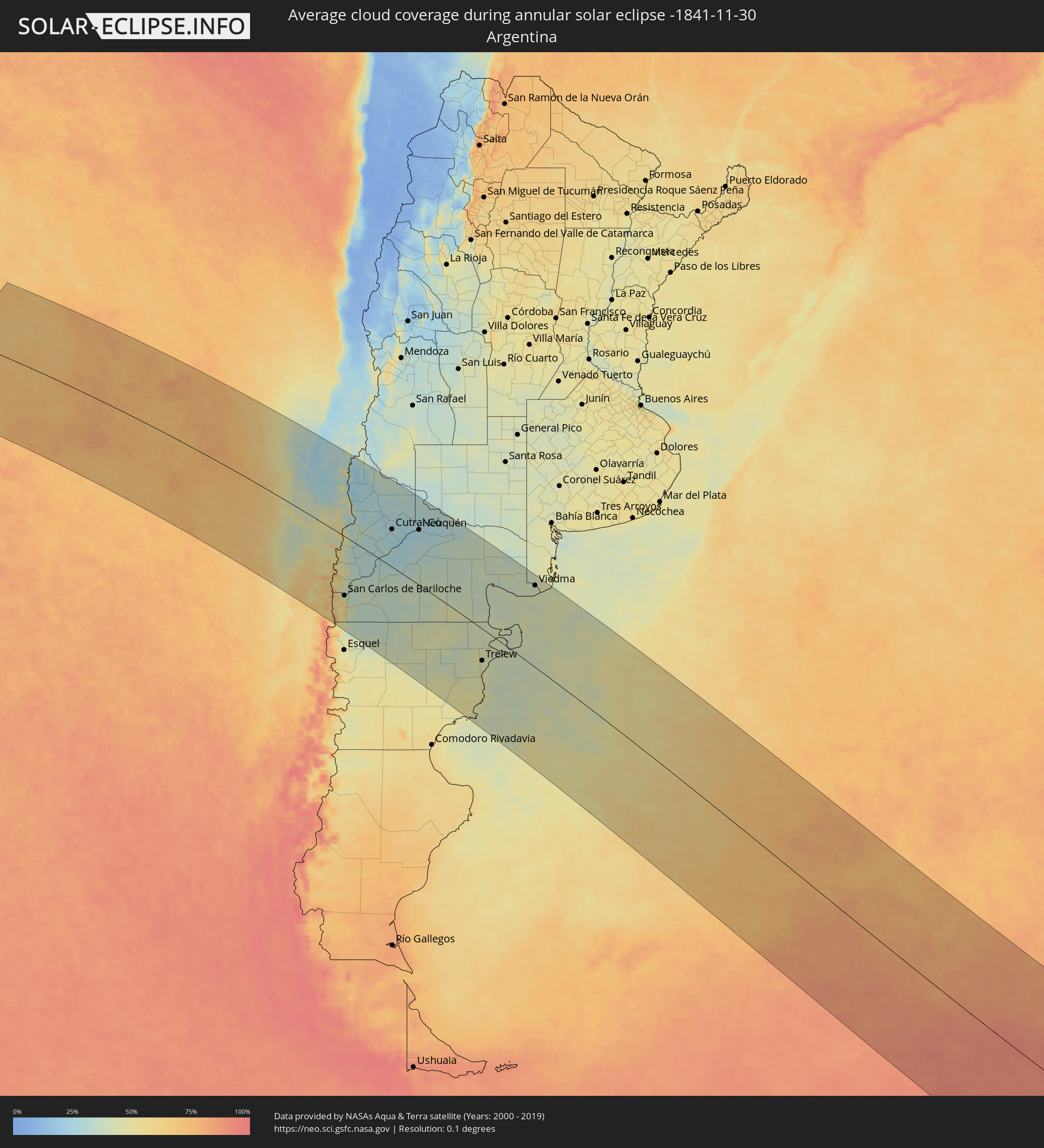 Argentina
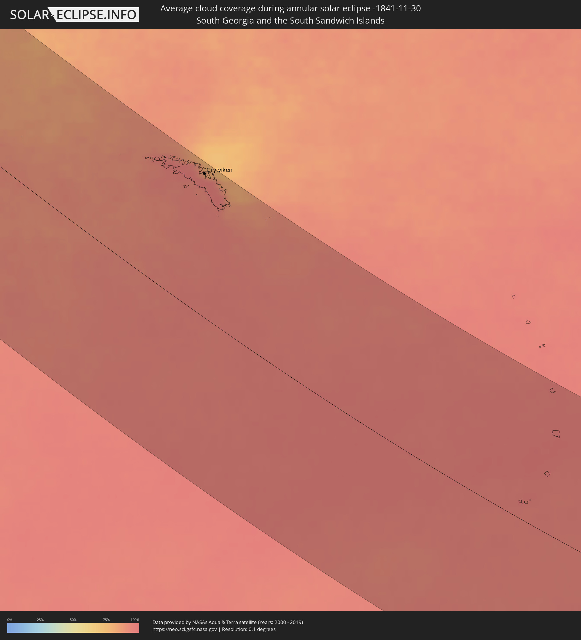 South Georgia and the South Sandwich Islands
 Heard Island and McDonald Islands
Cities inside the path of the eclipse
The following table shows all locations with a population of more than 5,000 inside the eclipse path. Cities which have more than 100,000 inhabitants are marked bold. A click at the locations opens a detailed map.
| City | Type | Eclipse duration | Local time of max. eclipse | Distance to central line | Ø Cloud coverage |
|
Lebu, Biobío
|
annular | - | 06:17:12 UTC-04:42 | 43 km | 47% |
|
Cañete, Biobío
|
annular | - | 06:17:30 UTC-04:42 | 37 km | 39% |
|
Curanilahue, Biobío
|
annular | - | 06:16:58 UTC-04:42 | 73 km | 37% |
|
Arauco, Biobío
|
annular | - | 06:16:35 UTC-04:42 | 93 km | 36% |
|
Valdivia, Los Ríos
|
annular | - | 06:20:54 UTC-04:42 | 150 km | 47% |
|
Las Animas, Los Lagos
|
annular | - | 06:20:53 UTC-04:42 | 148 km | 47% |
|
Carahue, Araucanía
|
annular | - | 06:19:01 UTC-04:42 | 42 km | 45% |
|
Purranque, Los Lagos
|
annular | - | 06:22:48 UTC-04:42 | 248 km | 65% |
|
Lota, Biobío
|
annular | - | 06:16:19 UTC-04:42 | 116 km | 35% |
|
Coronel, Biobío
|
annular | - | 06:16:13 UTC-04:42 | 122 km | 31% |
|
Osorno, Los Lagos
|
annular | - | 06:22:12 UTC-04:42 | 215 km | 64% |
|
Talcahuano, Biobío
|
annular | - | 06:15:42 UTC-04:42 | 151 km | 30% |
|
La Unión, Los Ríos
|
annular | - | 06:21:43 UTC-04:42 | 187 km | 62% |
|
Concepción, Biobío
|
annular | - | 06:15:52 UTC-04:42 | 145 km | 31% |
|
Frutillar, Los Lagos
|
annular | - | 06:23:10 UTC-04:42 | 263 km | 59% |
|
Chiguayante, Biobío
|
annular | - | 06:16:02 UTC-04:42 | 137 km | 27% |
|
Penco, Biobío
|
annular | - | 06:15:43 UTC-04:42 | 155 km | 31% |
|
Puerto Varas, Los Lagos
|
annular | - | 06:23:30 UTC-04:42 | 279 km | 66% |
|
Tomé, Biobío
|
annular | - | 06:15:31 UTC-04:42 | 169 km | 34% |
|
Río Bueno, Los Ríos
|
annular | - | 06:21:47 UTC-04:42 | 185 km | 63% |
|
Nueva Imperial, Araucanía
|
annular | - | 06:19:04 UTC-04:42 | 42 km | 44% |
|
Puerto Montt, Los Lagos
|
annular | - | 06:23:46 UTC-04:42 | 290 km | 64% |
|
Angol, Araucanía
|
annular | - | 06:17:27 UTC-04:42 | 67 km | 36% |
|
La Laja, Biobío
|
annular | - | 06:16:36 UTC-04:42 | 116 km | 27% |
|
Nacimiento, Biobío
|
annular | - | 06:16:58 UTC-04:42 | 99 km | 30% |
|
Traiguén, Araucanía
|
annular | - | 06:18:13 UTC-04:42 | 31 km | 41% |
|
Pitrufquén, Araucanía
|
annular | - | 06:19:28 UTC-04:42 | 45 km | 45% |
|
Loncoche, Araucanía
|
annular | - | 06:20:07 UTC-04:42 | 79 km | 46% |
|
Freire, Araucanía
|
annular | - | 06:19:24 UTC-04:42 | 41 km | 45% |
|
Temuco, Araucanía
|
annular | - | 06:19:03 UTC-04:42 | 18 km | 49% |
|
Yumbel, Biobío
|
annular | - | 06:16:17 UTC-04:42 | 141 km | 27% |
|
Lautaro, Araucanía
|
annular | - | 06:18:41 UTC-04:42 | 9 km | 46% |
|
Collipulli, Araucanía
|
annular | - | 06:17:43 UTC-04:42 | 67 km | 36% |
|
Cabrero, Biobío
|
annular | - | 06:16:10 UTC-04:42 | 155 km | 26% |
|
Los Ángeles, Biobío
|
annular | - | 06:16:54 UTC-04:42 | 114 km | 28% |
|
Victoria, Araucanía
|
annular | - | 06:18:11 UTC-04:42 | 43 km | 44% |
|
Panguipulli, Araucanía
|
annular | - | 06:20:35 UTC-04:42 | 91 km | 45% |
|
Cauquenes, Maule
|
annular | - | 06:14:25 UTC-04:42 | 261 km | 28% |
|
Bulnes, Biobío
|
annular | - | 06:15:41 UTC-04:42 | 187 km | 29% |
|
Mulchén, Biobío
|
annular | - | 06:17:18 UTC-04:42 | 97 km | 30% |
|
Villarrica, Araucanía
|
annular | - | 06:19:58 UTC-04:42 | 53 km | 47% |
|
Vilcún, Araucanía
|
annular | - | 06:18:55 UTC-04:42 | 25 km | 48% |
|
Chillán, Biobío
|
annular | - | 06:15:27 UTC-04:42 | 209 km | 29% |
|
San Carlos, Biobío
|
annular | - | 06:15:08 UTC-04:42 | 233 km | 30% |
|
Pucón, Araucanía
|
annular | - | 06:19:58 UTC-04:42 | 45 km | 51% |
|
Coihueco, Biobío
|
annular | - | 06:15:28 UTC-04:42 | 219 km | 29% |
|
Parral, Maule
|
annular | - | 06:14:40 UTC-04:42 | 266 km | 31% |
|
Villa La Angostura, Neuquén Province
|
annular | - | 06:48:30 UTC-04:16 | 165 km | 44% |
|
El Bolsón, Río Negro Province
|
annular | - | 06:50:38 UTC-04:16 | 271 km | 49% |
|
San Martín de los Andes, Neuquén Province
|
annular | - | 06:47:27 UTC-04:16 | 98 km | 49% |
|
San Carlos de Bariloche, Río Negro Province
|
annular | - | 06:49:11 UTC-04:16 | 185 km | 35% |
|
Junín de los Andes, Neuquén Province
|
annular | - | 06:47:06 UTC-04:16 | 64 km | 34% |
|
Chos Malal, Neuquén Province
|
annular | - | 06:42:40 UTC-04:16 | 218 km | 27% |
|
Zapala, Neuquén Province
|
annular | - | 06:45:17 UTC-04:16 | 84 km | 31% |
|
Ingeniero Jacobacci, Río Negro Province
|
annular | - | 06:49:37 UTC-04:16 | 121 km | 37% |
|
Cutral-Có, Neuquén Province
|
annular | - | 06:45:23 UTC-04:16 | 119 km | 31% |
|
Plaza Huincul, Neuquén Province
|
annular | - | 06:45:23 UTC-04:16 | 121 km | 31% |
|
Senillosa, Neuquén Province
|
annular | - | 06:45:35 UTC-04:16 | 149 km | 25% |
|
Plottier, Neuquén Province
|
annular | - | 06:45:31 UTC-04:16 | 164 km | 25% |
|
Centenario, Neuquén Province
|
annular | - | 06:45:17 UTC-04:16 | 181 km | 26% |
|
Cinco Saltos, Río Negro Province
|
annular | - | 06:45:17 UTC-04:16 | 185 km | 26% |
|
Neuquén, Neuquén Province
|
annular | - | 06:45:30 UTC-04:16 | 172 km | 27% |
|
Cipolletti, Río Negro Province
|
annular | - | 06:45:29 UTC-04:16 | 177 km | 29% |
|
General Fernández Oro, Río Negro Province
|
annular | - | 06:45:31 UTC-04:16 | 178 km | 27% |
|
Allen, Río Negro Province
|
annular | - | 06:45:34 UTC-04:16 | 180 km | 27% |
|
General Roca, Río Negro Province
|
annular | - | 06:45:42 UTC-04:16 | 188 km | 29% |
|
Cervantes, Río Negro Province
|
annular | - | 06:45:45 UTC-04:16 | 195 km | 28% |
|
Ingeniero Luis A. Huergo, Río Negro Province
|
annular | - | 06:45:49 UTC-04:16 | 198 km | 29% |
|
Villa Regina, Río Negro Province
|
annular | - | 06:45:52 UTC-04:16 | 205 km | 30% |
|
Fray Luis Beltrán, Río Negro Province
|
annular | - | 06:46:27 UTC-04:16 | 246 km | 38% |
|
Lamarque, Río Negro Province
|
annular | - | 06:46:39 UTC-04:16 | 240 km | 37% |
|
Choele Choel, Río Negro Province
|
annular | - | 06:46:22 UTC-04:16 | 255 km | 38% |
|
Gaimán, Chubut Province
|
annular | - | 06:53:51 UTC-04:16 | 107 km | 45% |
|
Sierra Grande, Río Negro Province
|
annular | - | 06:50:43 UTC-04:16 | 59 km | 37% |
|
Trelew, Chubut Province
|
annular | - | 06:53:49 UTC-04:16 | 93 km | 46% |
|
Rawson, Chubut Province
|
annular | - | 06:53:58 UTC-04:16 | 87 km | 43% |
|
Puerto Madryn, Chubut Province
|
annular | - | 06:52:58 UTC-04:16 | 42 km | 43% |
|
San Antonio Oeste, Río Negro Province
|
annular | - | 06:49:11 UTC-04:16 | 154 km | 44% |
|
General Conesa, Río Negro Province
|
annular | - | 06:48:07 UTC-04:16 | 237 km | 37% |
|
Viedma, Río Negro Province
|
annular | - | 06:49:47 UTC-04:16 | 240 km | 40% |
|
Grytviken
|
annular | - | 09:52:46 UTC-02:00 | 216 km | 93% |