Total solar eclipse of 08/14/-1937
| Day of week: | Sunday |
| Maximum duration of eclipse: | 05m05s |
| Maximum width of eclipse path: | 190 km |
| Saros cycle: | 14 |
| Coverage: | 100% |
| Magnitude: | 1.0574 |
| Gamma: | -0.0934 |
Wo kann man die Sonnenfinsternis vom 08/14/-1937 sehen?
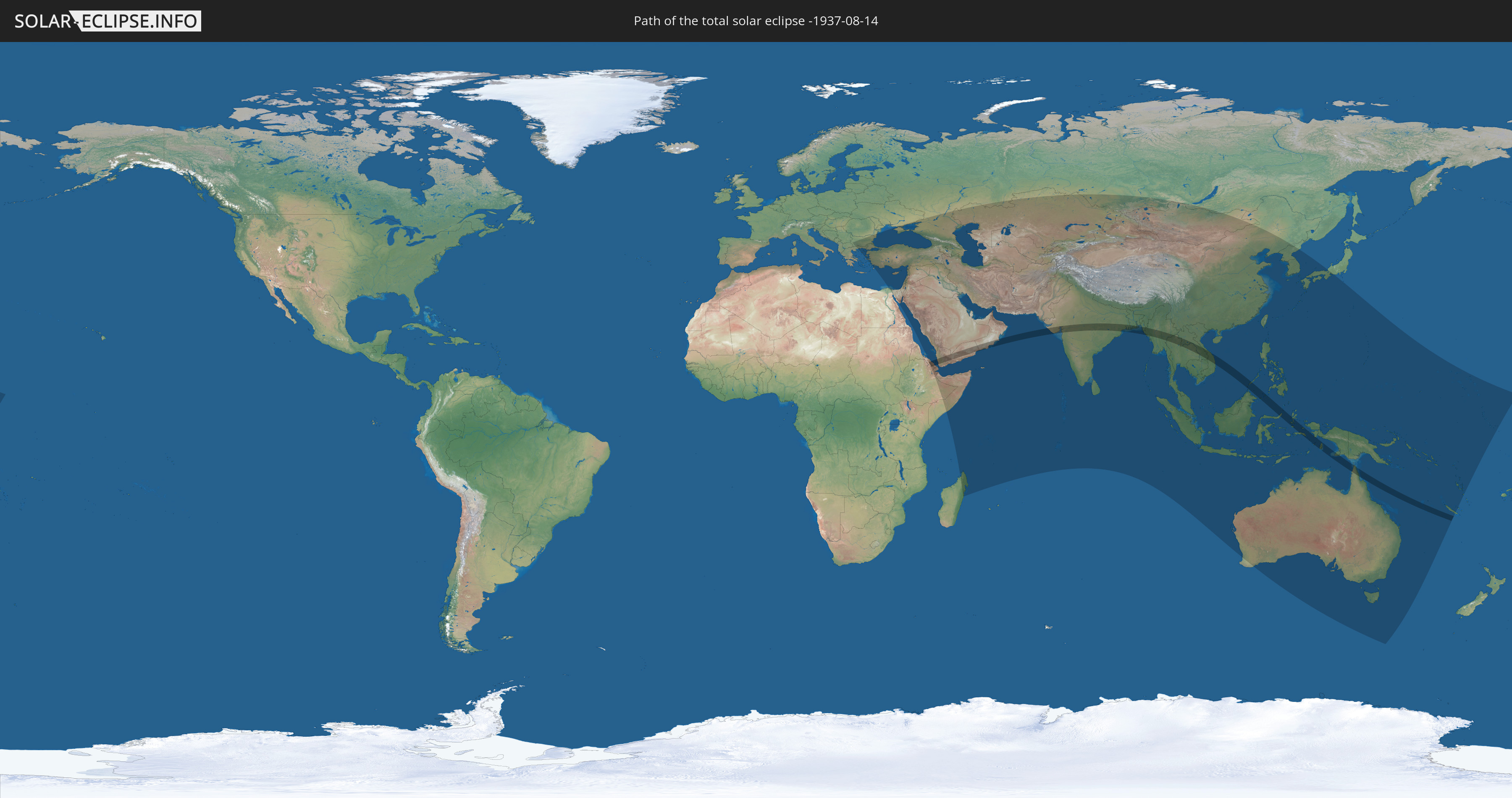
Die Sonnenfinsternis am 08/14/-1937 kann man in 80 Ländern als partielle Sonnenfinsternis beobachten.
Der Finsternispfad verläuft durch 15 Länder. Nur in diesen Ländern ist sie als total Sonnenfinsternis zu sehen.
In den folgenden Ländern ist die Sonnenfinsternis total zu sehen
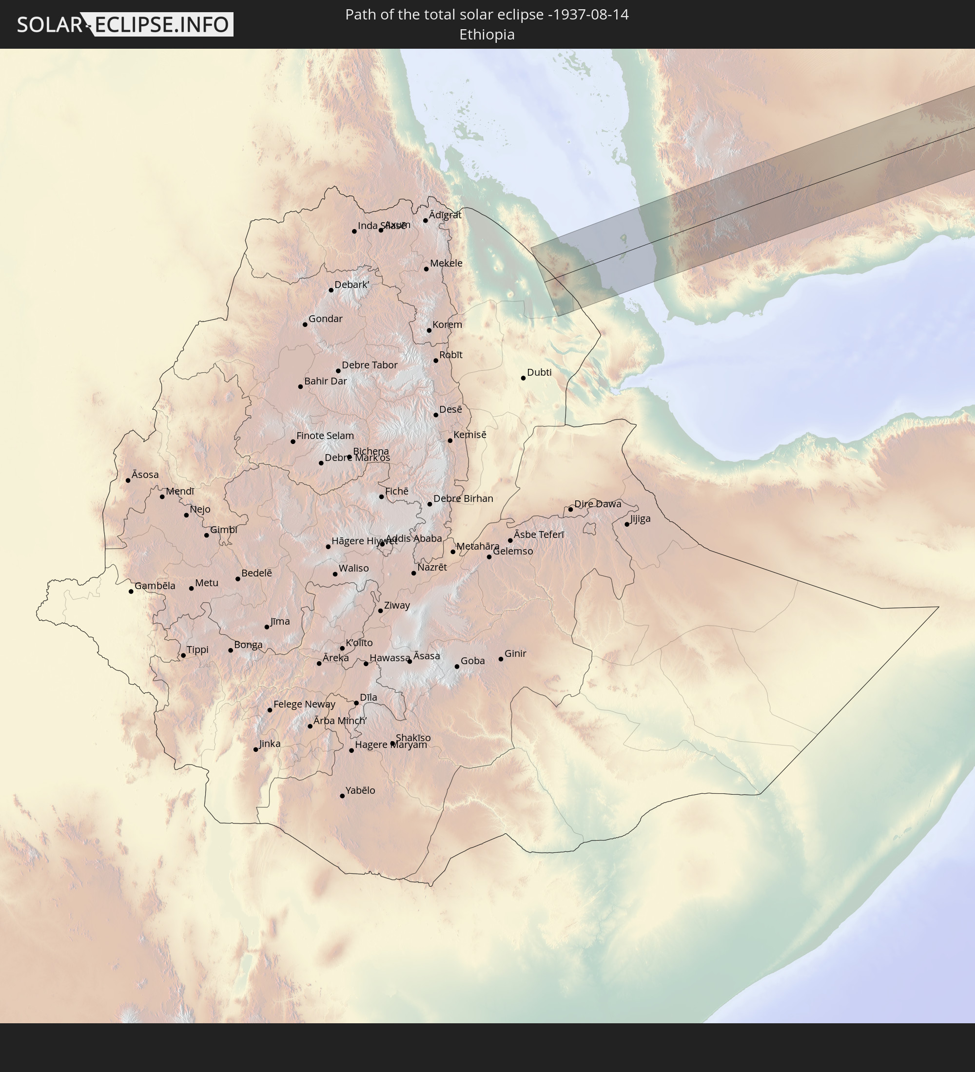 Ethiopia
 Eritrea
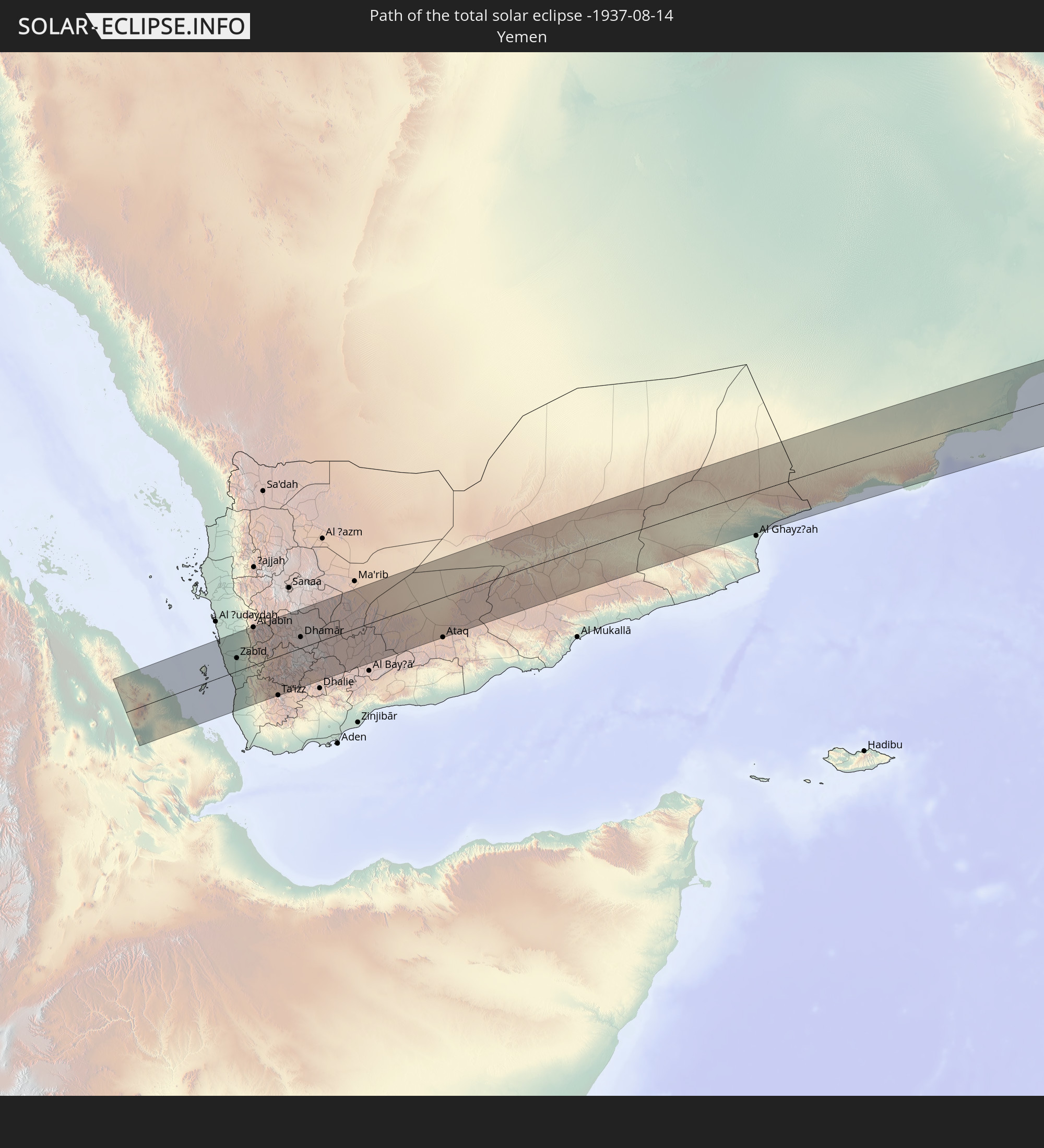 Yemen
Yemen
 Oman
Oman
 India
India
 Bangladesh
 Myanmar
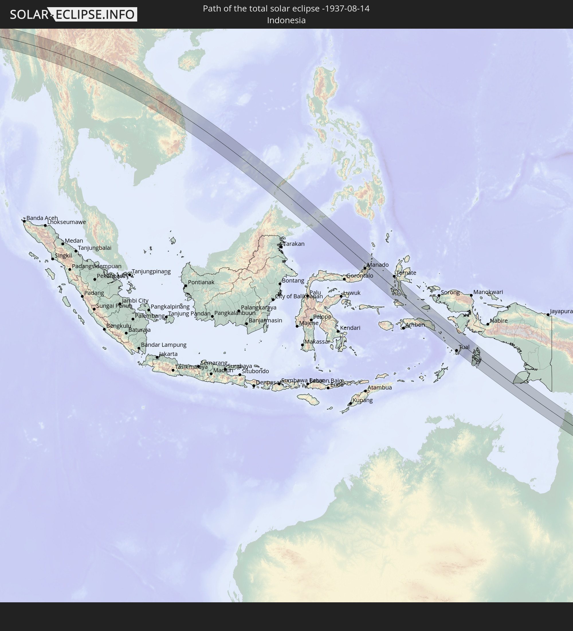 Indonesia
 Thailand
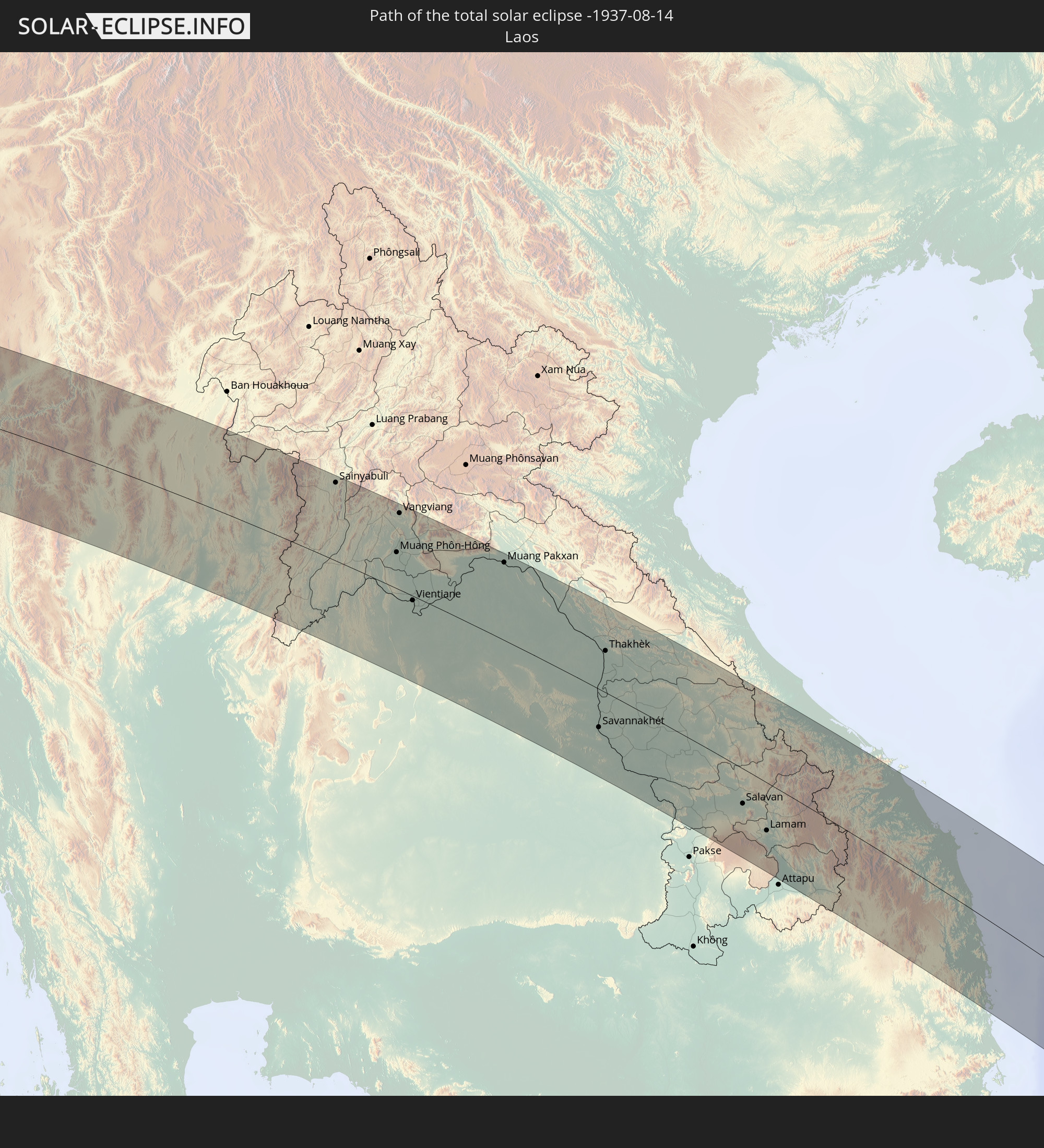 Laos
Laos
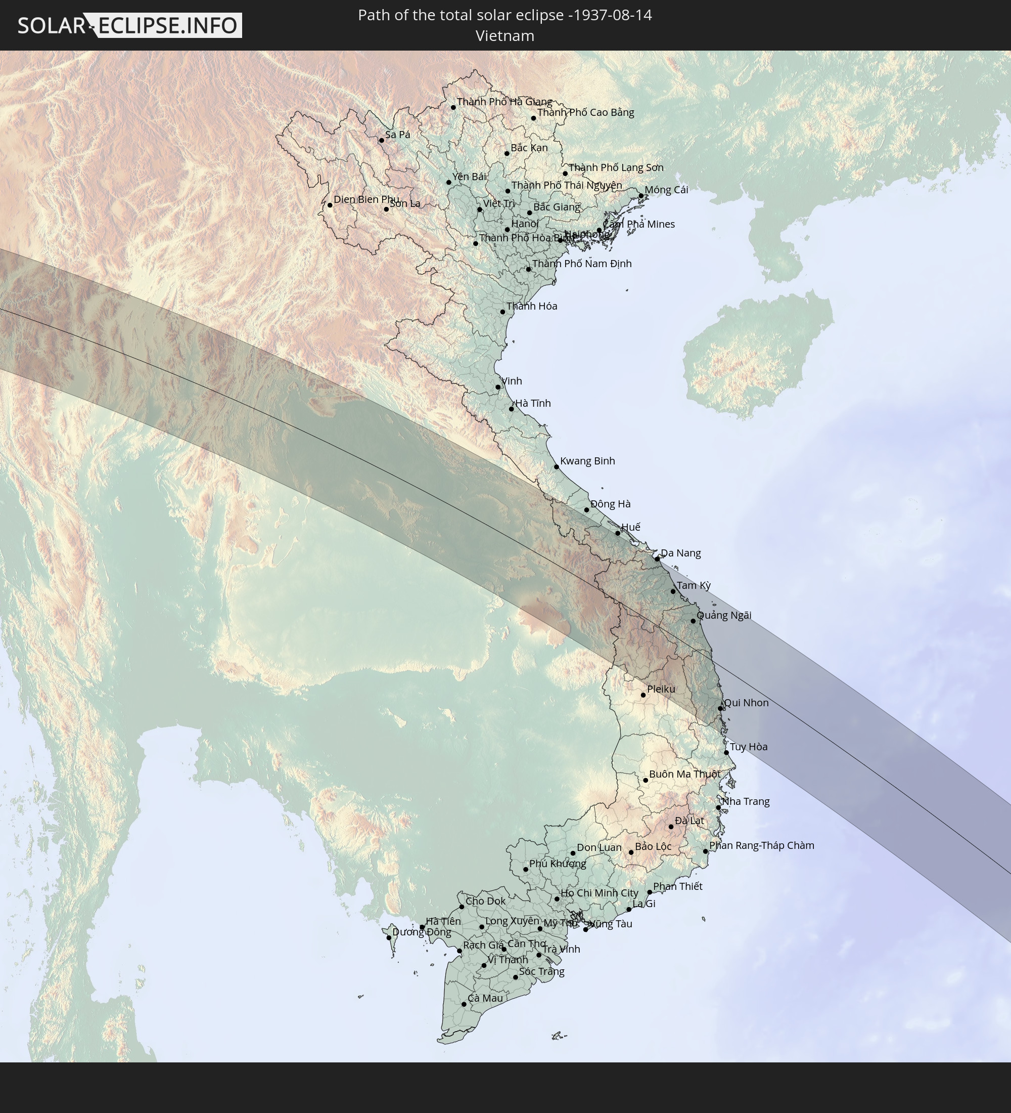 Vietnam
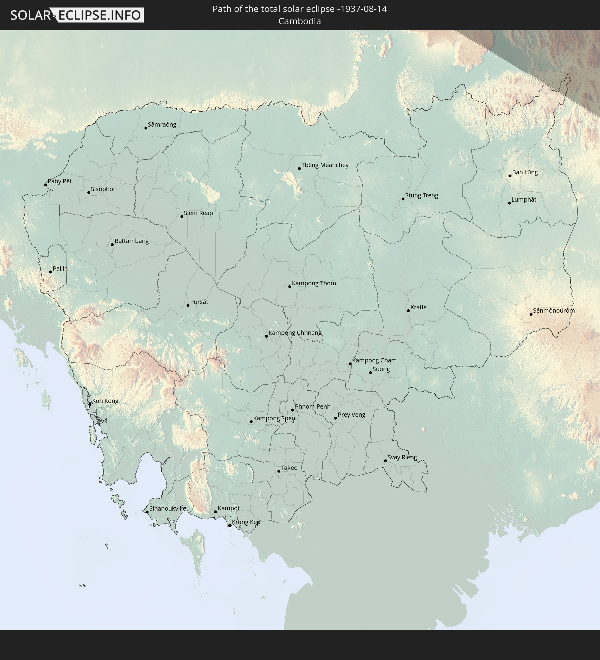 Cambodia
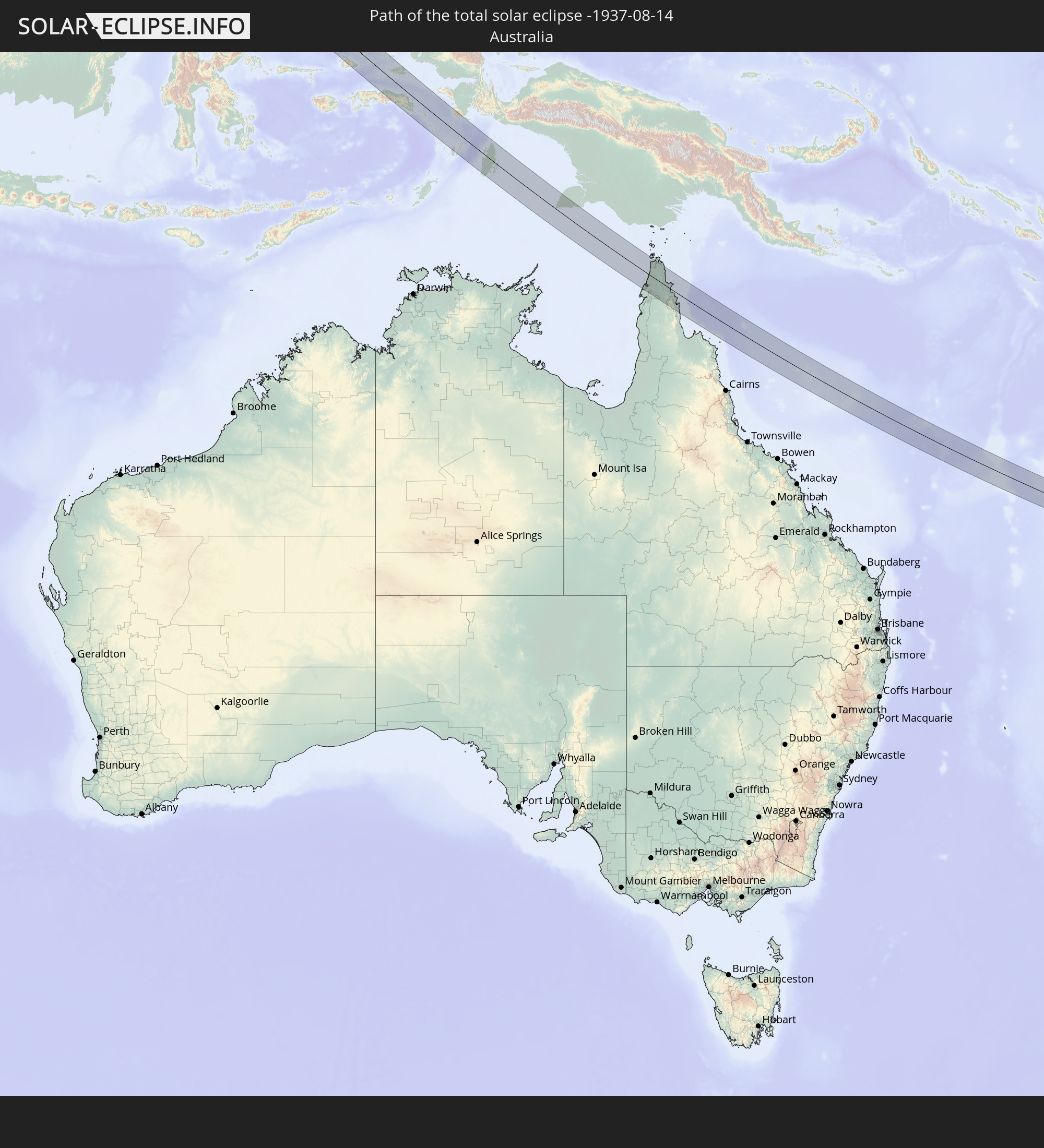 Australia
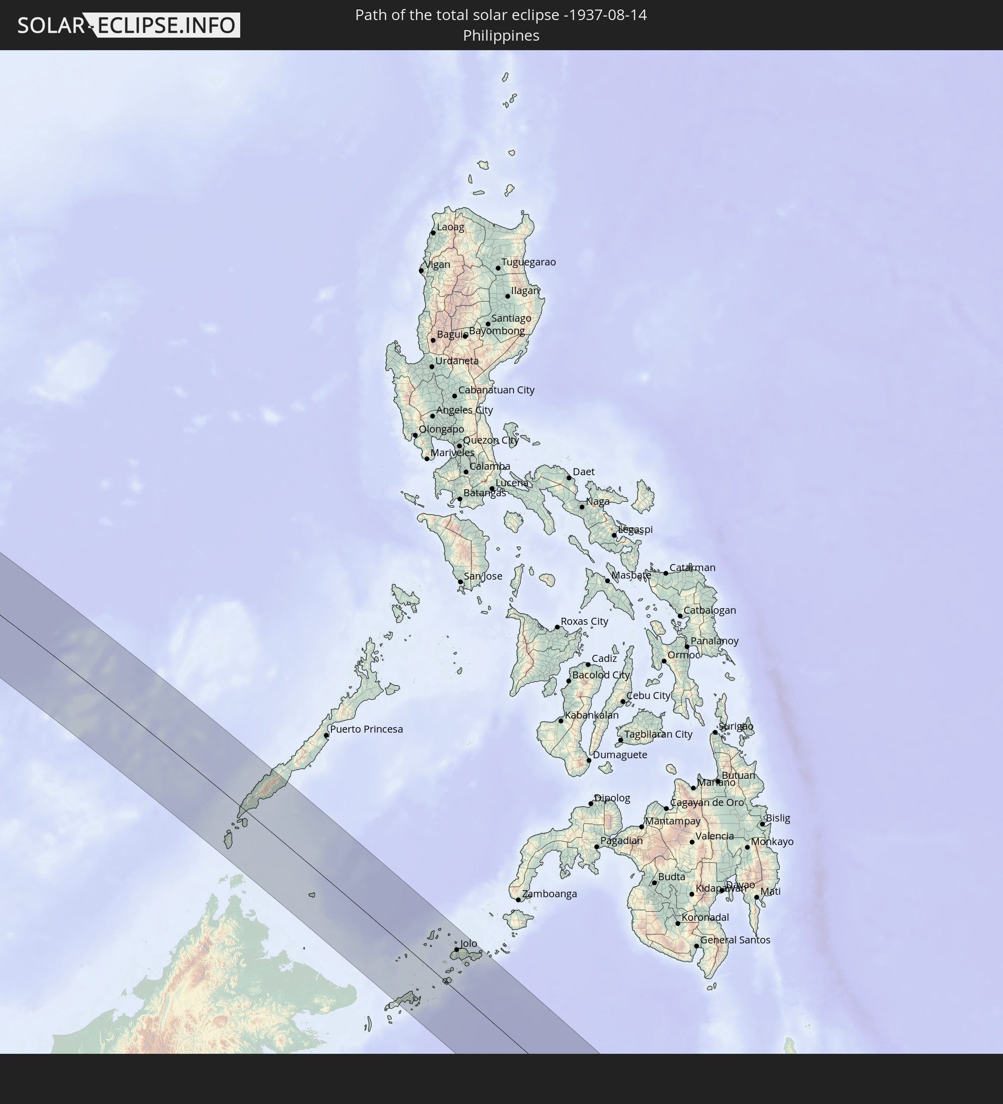 Philippines
 New Caledonia
In den folgenden Ländern ist die Sonnenfinsternis partiell zu sehen
 Russia
 Kiribati
 Greece
 Romania
 Ukraine
 Bulgaria
 Egypt
Egypt
 Turkey
 Cyprus
 Ethiopia
 State of Palestine
 Israel
 Saudi Arabia
 Jordan
 Lebanon
 Syria
Syria
 Eritrea
 Iraq
Iraq
 Georgia
 French Southern and Antarctic Lands
 Somalia
 Djibouti
 Yemen
Yemen
 Madagascar
 Armenia
 Iran
Iran
 Azerbaijan
 Seychelles
 Kazakhstan
 Kuwait
 Bahrain
 Qatar
Qatar
 United Arab Emirates
 Oman
Oman
 Turkmenistan
 Uzbekistan
 Mauritius
 Afghanistan
 Pakistan
 Tajikistan
 India
India
 Kyrgyzstan
 British Indian Ocean Territory
 Maldives
 China
China
 Sri Lanka
 Nepal
Nepal
 Mongolia
 Bangladesh
 Bhutan
 Myanmar
 Indonesia
 Cocos Islands
 Thailand
 Malaysia
 Laos
Laos
 Vietnam
 Cambodia
 Singapore
 Christmas Island
 Australia
 Macau
Macau
 Hong Kong
 Brunei
 Taiwan
 Philippines
 Japan
Japan
 East Timor
 North Korea
 South Korea
 Palau
Palau
 Federated States of Micronesia
 Papua New Guinea
 Guam
Guam
 Northern Mariana Islands
 Solomon Islands
 New Caledonia
 Marshall Islands
 Vanuatu
 Nauru
Nauru
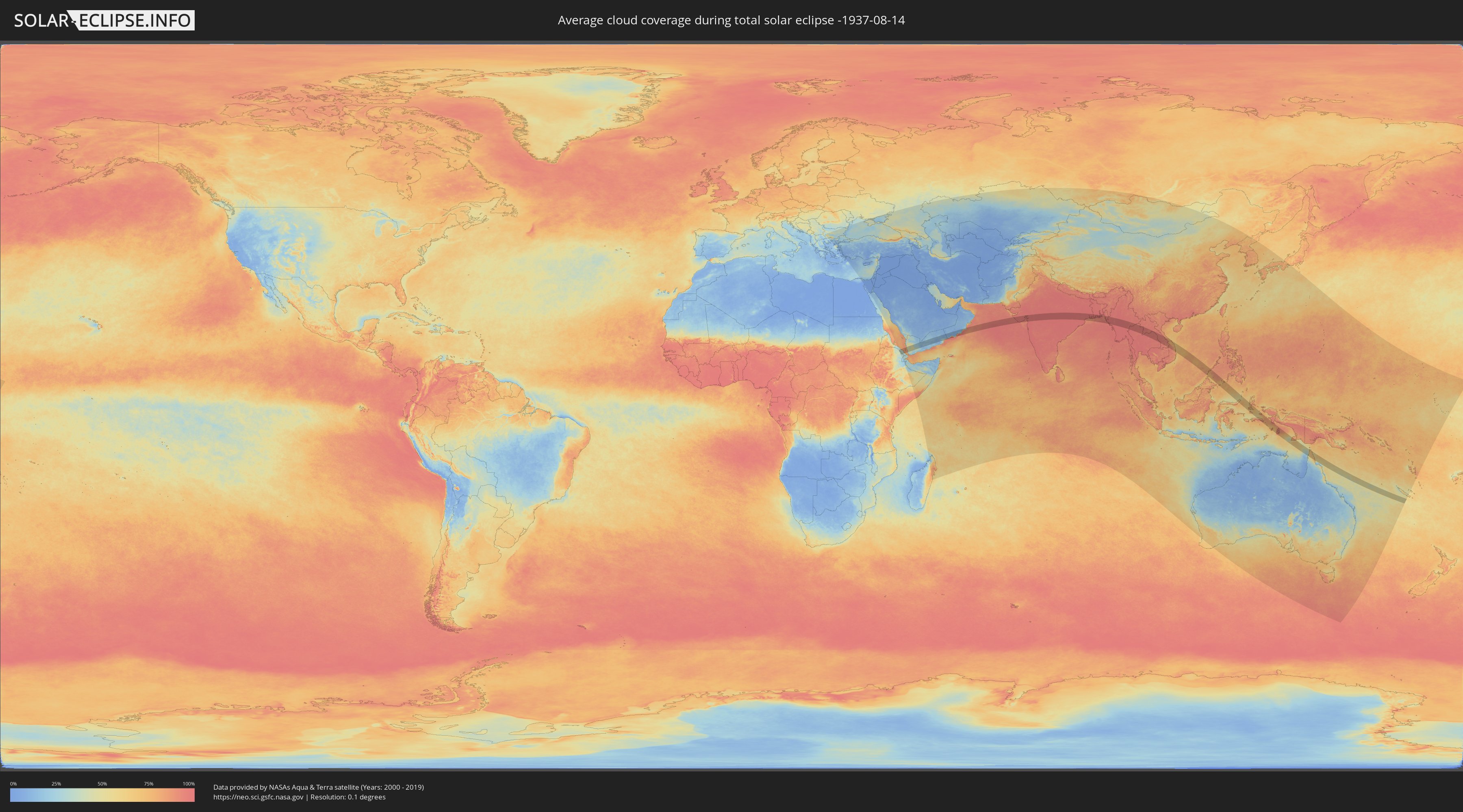
How will be the weather during the total solar eclipse on 08/14/-1937?
Where is the best place to see the total solar eclipse of 08/14/-1937?
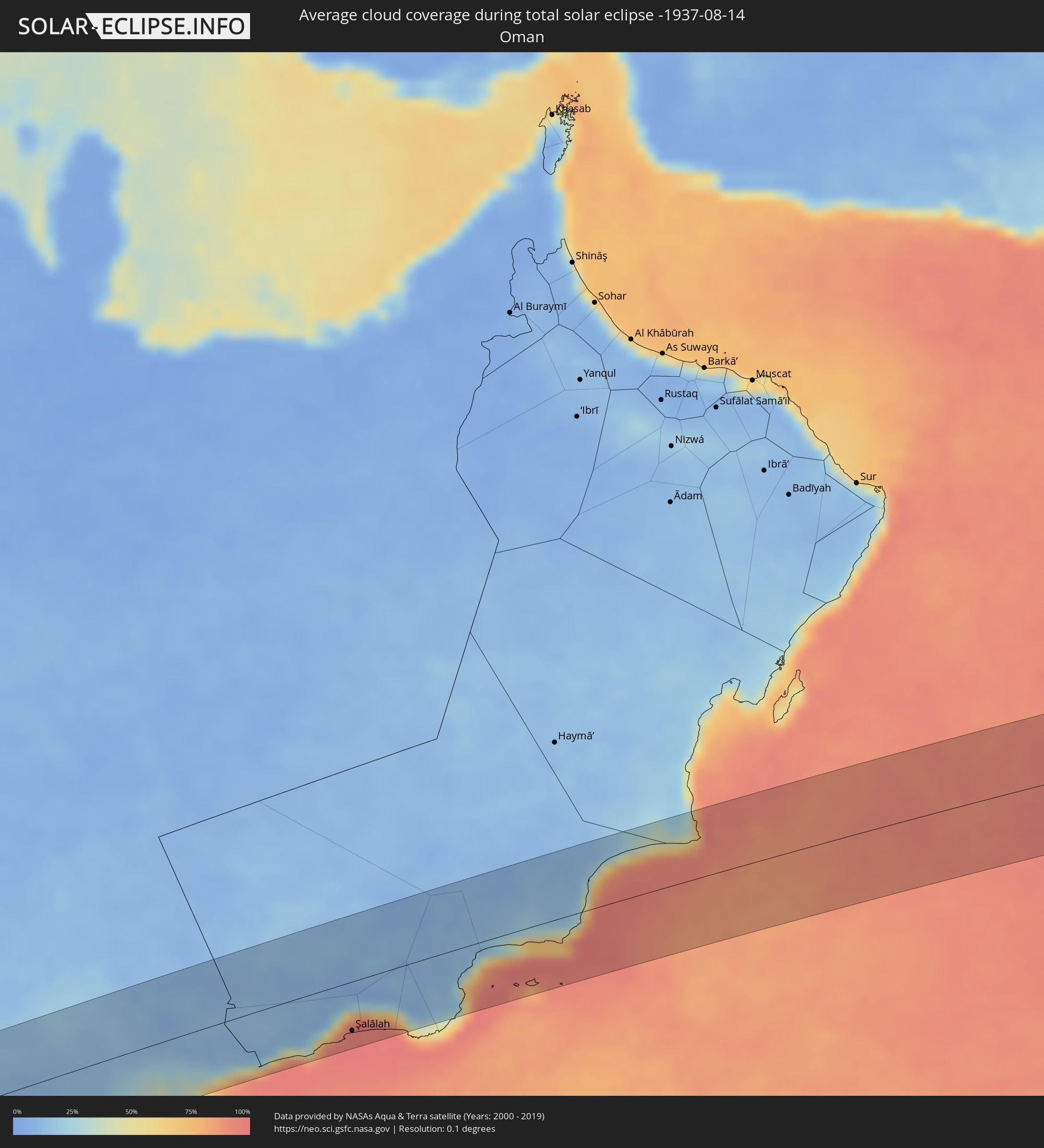
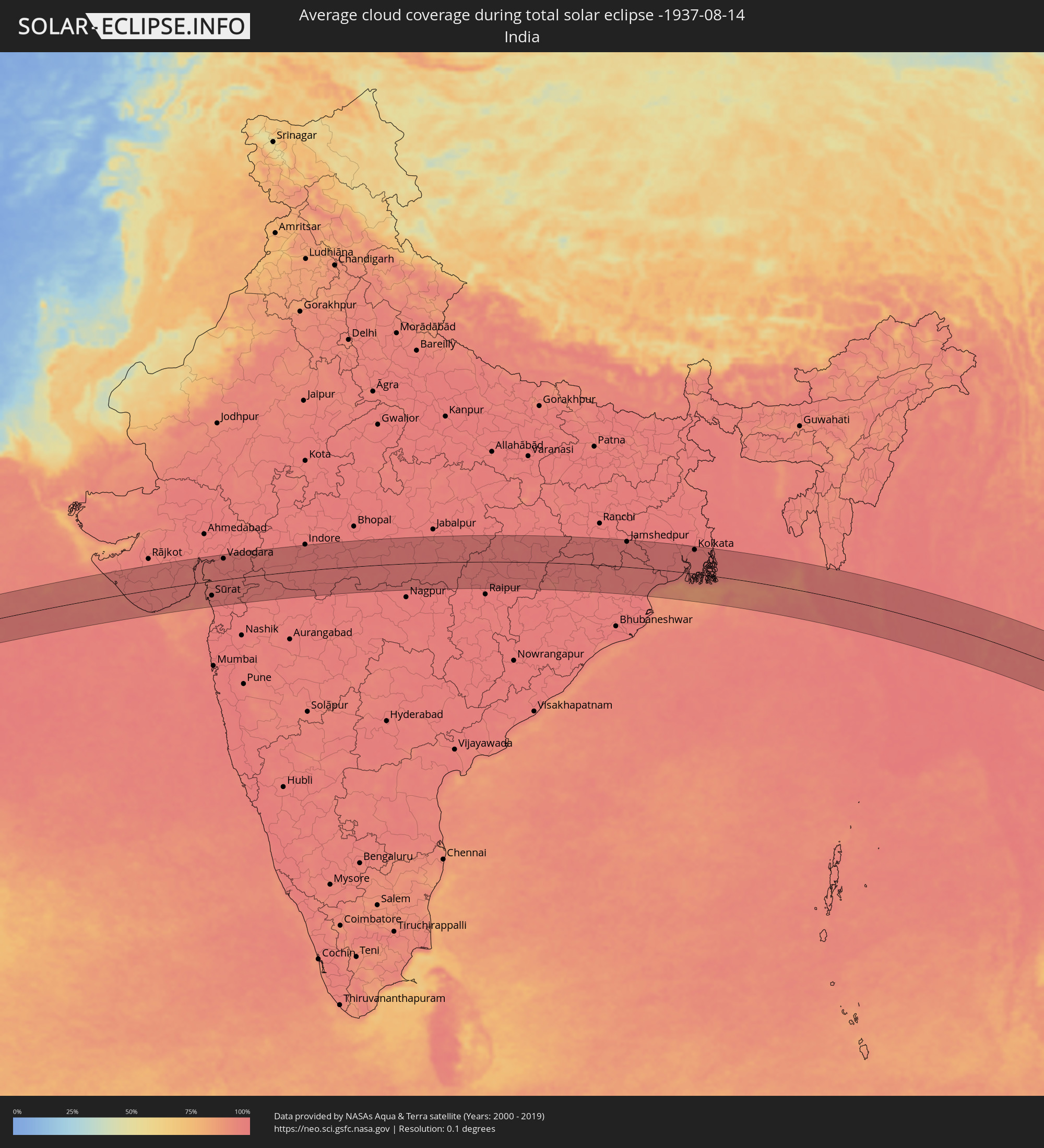
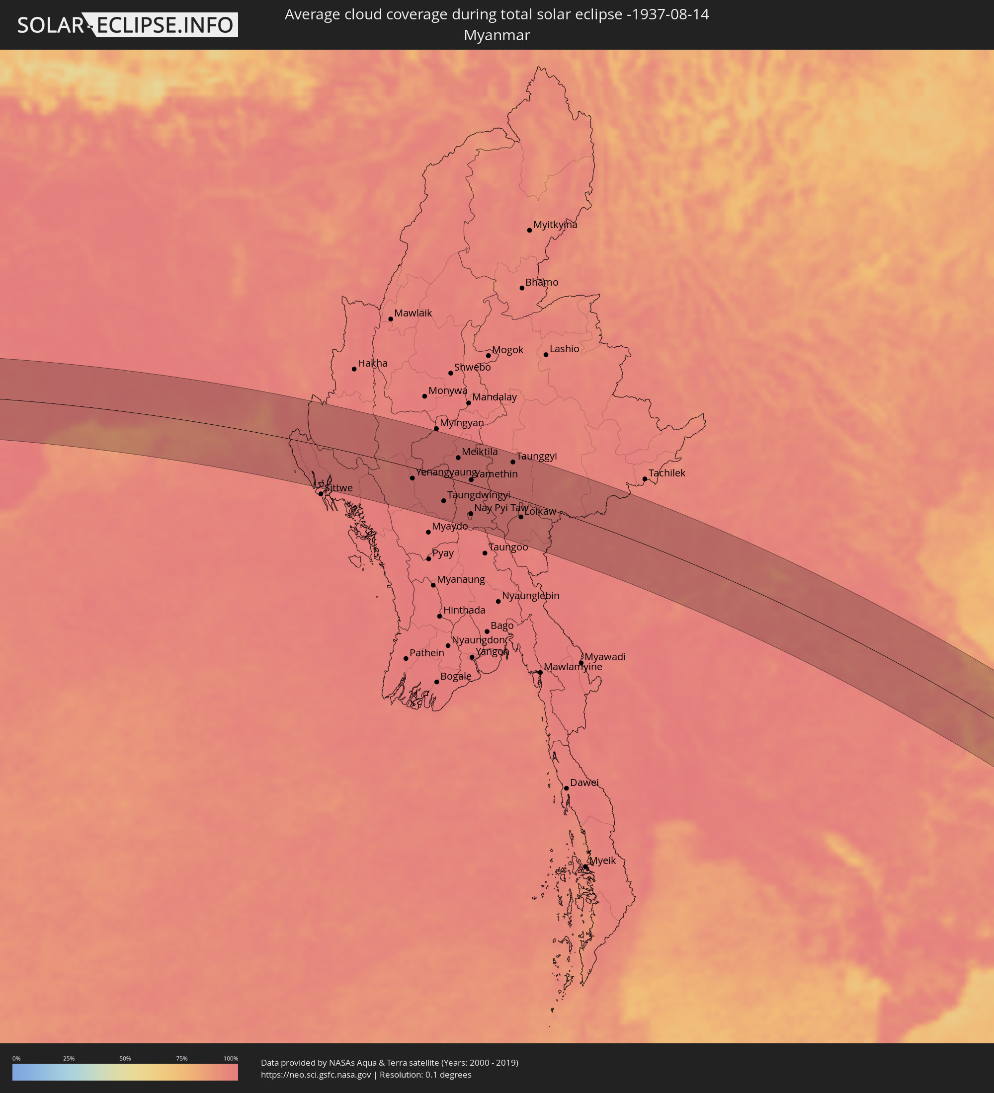
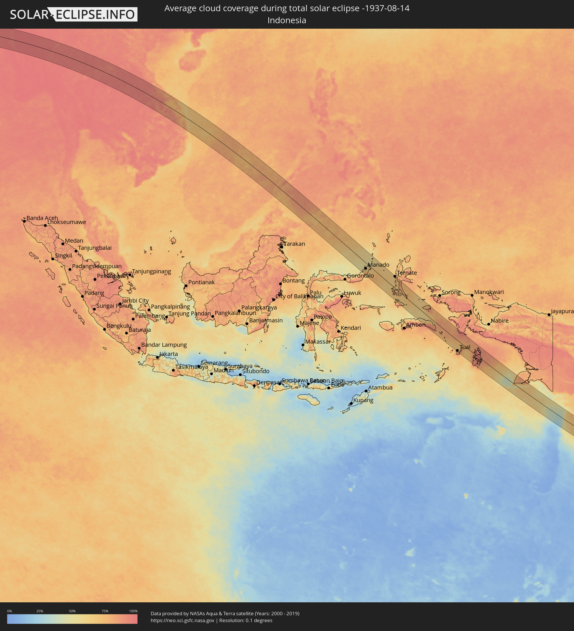
The following maps show the average cloud coverage for the day of the total solar eclipse.
With the help of these maps, it is possible to find the place along the eclipse path, which has the best
chance of a cloudless sky.
Nevertheless, you should consider local circumstances and inform about the weather of your chosen
observation site.
The data is provided by NASAs satellites
AQUA and TERRA.
The cloud maps are averaged over a period of 19 years (2000 - 2019).

Detailed country maps
 Ethiopia
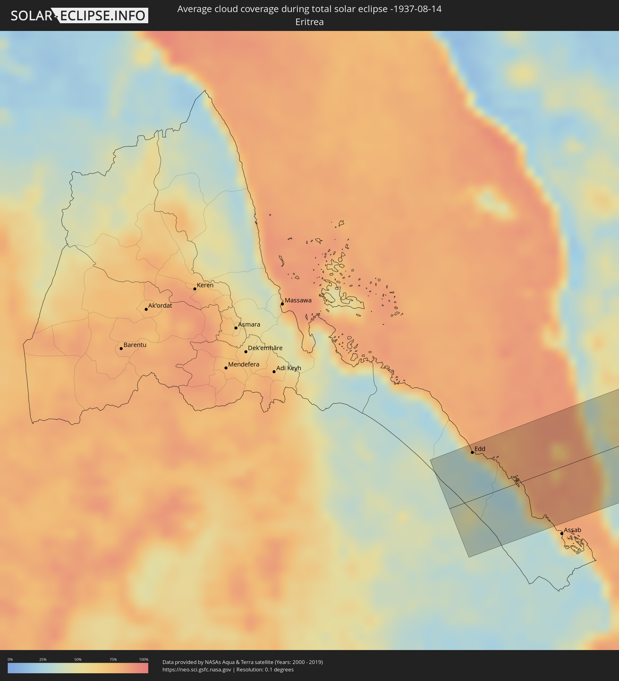 Eritrea
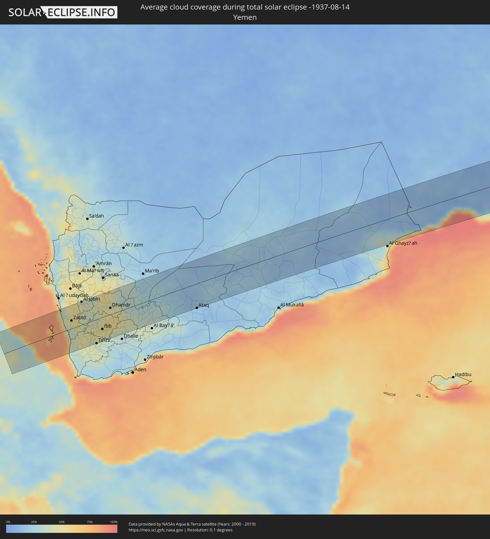 Yemen
Yemen
 Oman
Oman
 India
India
 Bangladesh
 Myanmar
 Indonesia
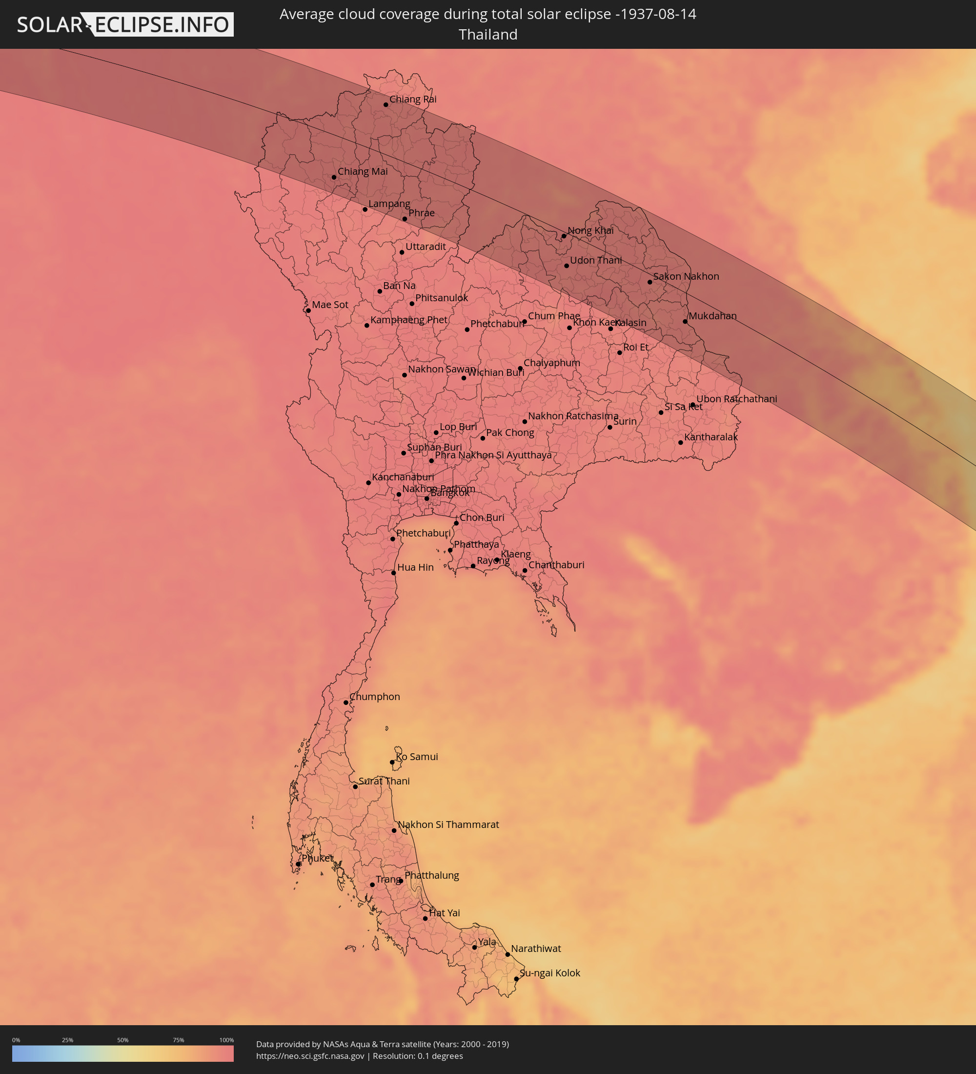 Thailand
 Laos
Laos
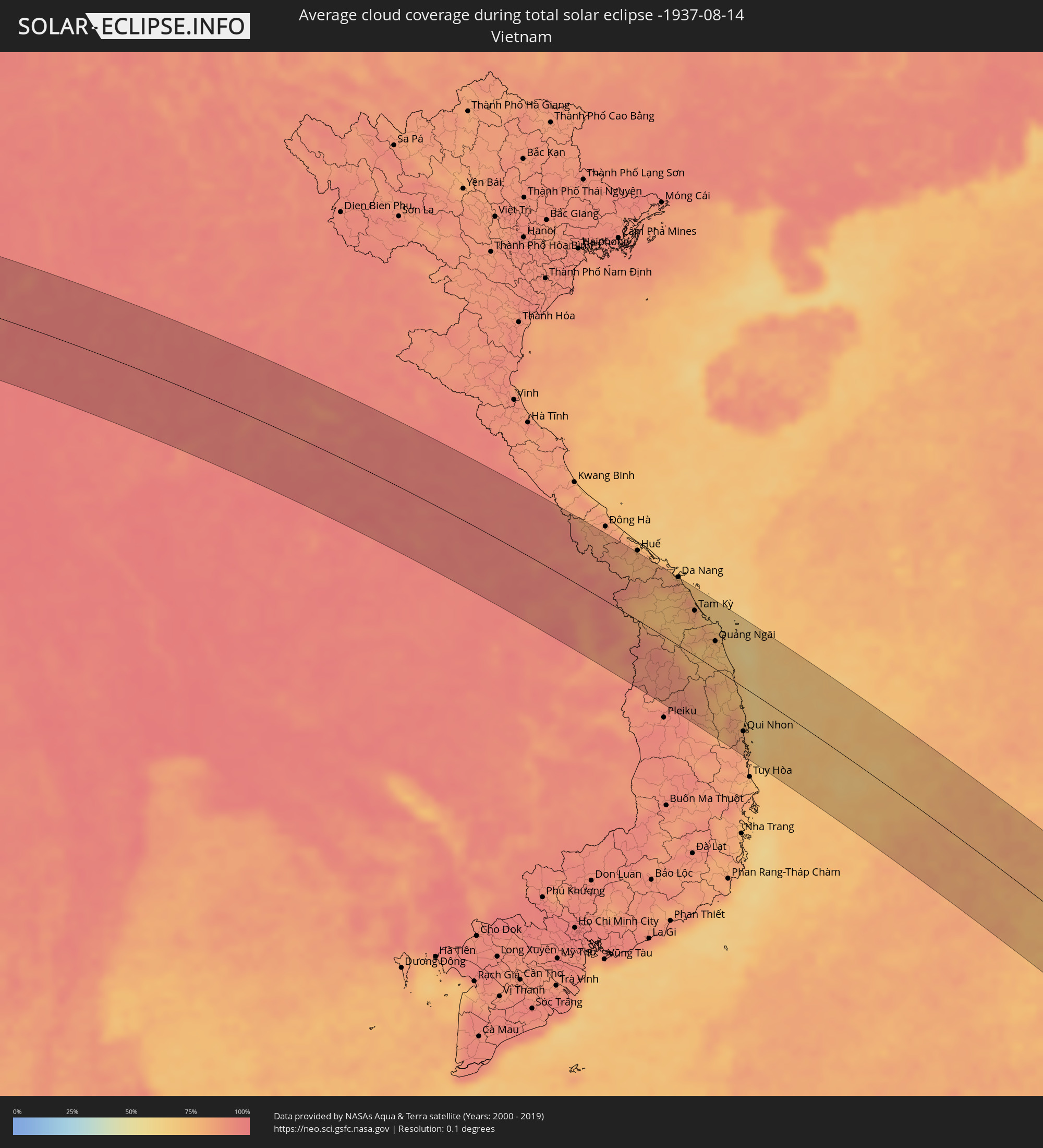 Vietnam
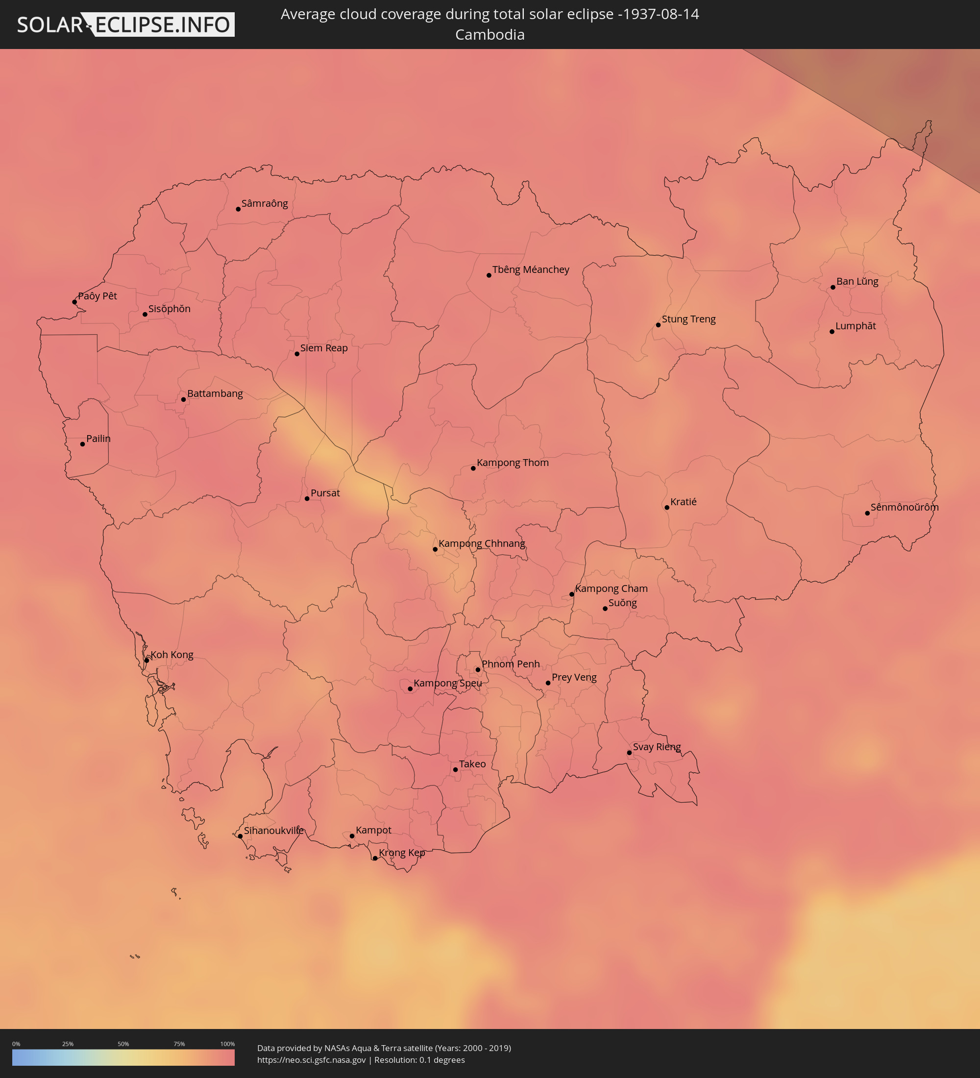 Cambodia
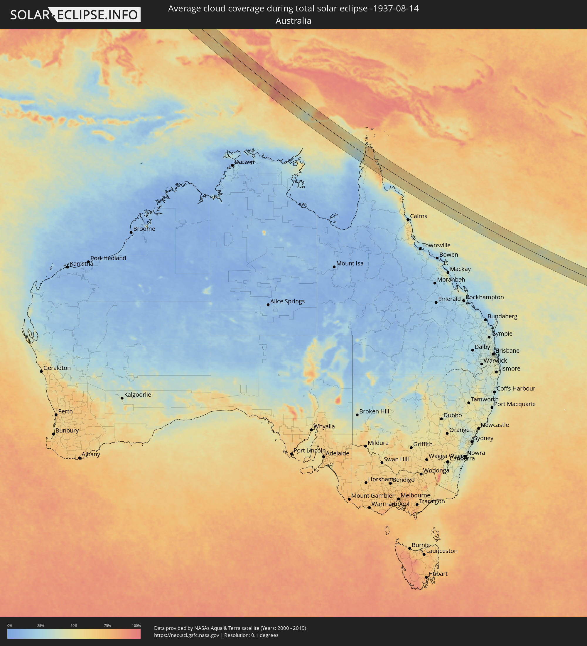 Australia
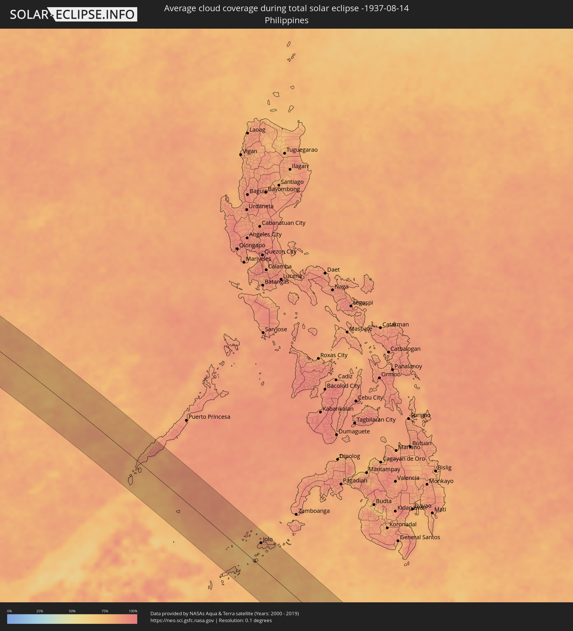 Philippines
 New Caledonia
Cities inside the path of the eclipse
The following table shows all locations with a population of more than 5,000 inside the eclipse path. Cities which have more than 100,000 inhabitants are marked bold. A click at the locations opens a detailed map.
| City | Type | Eclipse duration | Local time of max. eclipse | Distance to central line | Ø Cloud coverage |
|
Edd, Southern Red Sea
|
total | - | 05:24:58 UTC+02:27 | 56 km | 32% |
|
Zabīd, Muḩāfaz̧at al Ḩudaydah
|
total | - | 06:04:36 UTC+03:06 | 23 km | 44% |
|
Bayt al Faqīh, Muḩāfaz̧at al Ḩudaydah
|
total | - | 06:04:39 UTC+03:06 | 56 km | 47% |
|
Al Jabīn, Raymah
|
total | - | 06:04:41 UTC+03:06 | 65 km | 49% |
|
Dhī as Sufāl, Ibb
|
total | - | 06:04:35 UTC+03:06 | 45 km | 46% |
|
Ibb, Ibb
|
total | - | 06:04:36 UTC+03:06 | 33 km | 50% |
|
Yarīm, Ibb
|
total | - | 06:04:39 UTC+03:06 | 6 km | 54% |
|
Dhamār, Dhamār
|
total | - | 06:04:41 UTC+03:06 | 19 km | 50% |
|
Şalālah, Z̧ufār
|
total | - | 06:41:39 UTC+03:41 | 54 km | 96% |
|
Verāval, Gujarat
|
total | - | 08:34:59 UTC+05:21 | 42 km | 95% |
|
Jūnāgadh, Gujarat
|
total | - | 08:35:11 UTC+05:21 | 24 km | 97% |
|
Bhāvnagar, Gujarat
|
total | - | 08:37:15 UTC+05:21 | 26 km | 97% |
|
Sūrat, Gujarat
|
total | - | 08:38:04 UTC+05:21 | 48 km | 96% |
|
Vadodara, Gujarat
|
total | - | 08:38:40 UTC+05:21 | 69 km | 97% |
|
Māndu, Madhya Pradesh
|
total | - | 08:41:37 UTC+05:21 | 51 km | 97% |
|
Burhānpur, Madhya Pradesh
|
total | - | 08:42:49 UTC+05:21 | 74 km | 98% |
|
Khandwa, Madhya Pradesh
|
total | - | 08:43:00 UTC+05:21 | 18 km | 98% |
|
Punāsa, Madhya Pradesh
|
total | - | 08:43:04 UTC+05:21 | 27 km | 98% |
|
Bilāspur, Chhattisgarh
|
total | - | 08:52:31 UTC+05:21 | 14 km | 98% |
|
Korba, Chhattisgarh
|
total | - | 08:53:27 UTC+05:21 | 16 km | 98% |
|
Jamshedpur, Jharkhand
|
total | - | 08:59:55 UTC+05:21 | 83 km | 97% |
|
Kharagpur, West Bengal
|
total | - | 09:02:22 UTC+05:21 | 42 km | 98% |
|
Haldia, West Bengal
|
total | - | 09:04:06 UTC+05:21 | 20 km | 97% |
|
Nangi, West Bengal
|
total | - | 09:04:08 UTC+05:21 | 71 km | 97% |
|
Kolkata, West Bengal
|
total | - | 09:04:25 UTC+05:21 | 79 km | 98% |
|
Kultali, West Bengal
|
total | - | 09:04:47 UTC+05:21 | 6 km | 98% |
|
Bārāsat, West Bengal
|
total | - | 09:04:44 UTC+05:21 | 43 km | 98% |
|
Gosāba, West Bengal
|
total | - | 09:05:30 UTC+05:21 | 41 km | 98% |
|
Sarankhola, Khulna
|
total | - | 09:39:42 UTC+05:53 | 71 km | 97% |
|
Morrelgonj, Khulna
|
total | - | 09:39:46 UTC+05:53 | 88 km | 98% |
|
Mathba, Barisāl
|
total | - | 09:40:04 UTC+05:53 | 71 km | 97% |
|
Uttar Char Fasson, Khulna
|
total | - | 09:41:44 UTC+05:53 | 76 km | 98% |
|
Lālmohan, Barisāl
|
total | - | 09:41:43 UTC+05:53 | 89 km | 98% |
|
Cox’s Bāzār, Chittagong
|
total | - | 09:45:05 UTC+05:53 | 15 km | 95% |
|
Sātkania, Chittagong
|
total | - | 09:44:46 UTC+05:53 | 85 km | 97% |
|
Teknāf, Chittagong
|
total | - | 09:46:07 UTC+05:53 | 43 km | 97% |
|
Chauk, Magway
|
total | - | 10:23:24 UTC+06:24 | 22 km | 98% |
|
Yenangyaung, Magway
|
total | - | 10:23:53 UTC+06:24 | 23 km | 98% |
|
Minbu, Magway
|
total | - | 10:24:08 UTC+06:24 | 54 km | 97% |
|
Magway, Magway
|
total | - | 10:24:18 UTC+06:24 | 56 km | 97% |
|
Pakokku, Magway
|
total | - | 10:23:40 UTC+06:24 | 76 km | 97% |
|
Taungdwingyi, Magway
|
total | - | 10:25:54 UTC+06:24 | 54 km | 98% |
|
Meiktila, Mandalay
|
total | - | 10:25:53 UTC+06:24 | 48 km | 98% |
|
Nay Pyi Taw, Nay Pyi Taw
|
total | - | 10:27:33 UTC+06:24 | 64 km | 98% |
|
Yamethin, Mandalay
|
total | - | 10:26:57 UTC+06:24 | 9 km | 98% |
|
Pyinmana, Nay Pyi Taw
|
total | - | 10:27:45 UTC+06:24 | 63 km | 98% |
|
Taunggyi, Shan
|
total | - | 10:28:46 UTC+06:24 | 75 km | 97% |
|
Loikaw, Kayah
|
total | - | 10:30:15 UTC+06:24 | 38 km | 97% |
|
Chiang Mai, Chiang Mai
|
total | - | 10:52:52 UTC+06:42 | 69 km | 97% |
|
Lamphun, Lamphun
|
total | - | 10:53:09 UTC+06:42 | 90 km | 98% |
|
San Kamphaeng, Chiang Mai
|
total | - | 10:53:15 UTC+06:42 | 69 km | 97% |
|
Chiang Rai, Chiang Rai
|
total | - | 10:53:44 UTC+06:42 | 79 km | 96% |
|
Dok Kham Tai, Phayao
|
total | - | 10:54:58 UTC+06:42 | 8 km | 96% |
|
Phrae, Phrae
|
total | - | 10:56:31 UTC+06:42 | 91 km | 96% |
|
Nan, Nan
|
total | - | 10:57:22 UTC+06:42 | 0 km | 96% |
|
Sainyabuli, Xiagnabouli
|
total | - | 10:59:07 UTC+06:42 | 87 km | 95% |
|
Loei, Loei
|
total | - | 11:01:22 UTC+06:42 | 92 km | 97% |
|
Na Klang, Changwat Nong Bua Lamphu
|
total | - | 11:02:46 UTC+06:42 | 90 km | 98% |
|
Muang Phôn-Hông, Vientiane Province
|
total | - | 11:01:49 UTC+06:42 | 40 km | 95% |
|
Nong Bua Lamphu, Changwat Nong Bua Lamphu
|
total | - | 11:03:33 UTC+06:42 | 89 km | 97% |
|
Vangviang, Vientiane Province
|
total | - | 11:01:21 UTC+06:42 | 85 km | 95% |
|
Kut Chap, Changwat Udon Thani
|
total | - | 11:03:35 UTC+06:42 | 61 km | 94% |
|
Tha Bo, Nong Khai
|
total | - | 11:03:04 UTC+06:42 | 17 km | 94% |
|
Vientiane, Vientiane
|
total | - | 11:02:57 UTC+06:42 | 5 km | 96% |
|
Nong Khai, Nong Khai
|
total | - | 11:03:26 UTC+06:42 | 7 km | 94% |
|
Udon Thani, Changwat Udon Thani
|
total | - | 11:04:09 UTC+06:42 | 52 km | 94% |
|
Ban Phan Don, Changwat Udon Thani
|
total | - | 11:04:59 UTC+06:42 | 71 km | 96% |
|
Ban Nong Wua So, Changwat Udon Thani
|
total | - | 11:05:27 UTC+06:42 | 46 km | 96% |
|
Muang Pakxan, Bolikhamsai Province
|
total | - | 11:05:03 UTC+06:42 | 85 km | 95% |
|
Sakon Nakhon, Sakon Nakhon
|
total | - | 11:07:56 UTC+06:42 | 13 km | 96% |
|
Mukdahan, Mukdahan
|
total | - | 11:10:15 UTC+06:42 | 45 km | 97% |
|
Savannakhét, Savannahkhét
|
total | - | 11:10:18 UTC+06:42 | 42 km | 94% |
|
Nakhon Phanom, Nakhon Phanom
|
total | - | 11:09:10 UTC+06:42 | 43 km | 96% |
|
Thakhèk, Khammouan
|
total | - | 11:09:18 UTC+06:42 | 45 km | 96% |
|
Salavan, Salavan
|
total | - | 11:15:44 UTC+06:42 | 37 km | 94% |
|
Lamam, Xékong
|
total | - | 11:16:53 UTC+06:42 | 51 km | 89% |
|
Kon Tum, Kon Tum
|
total | - | 11:46:25 UTC+07:06 | 78 km | 88% |
|
Hội An, Quảng Nam
|
total | - | 11:44:49 UTC+07:06 | 84 km | 78% |
|
Tam Kỳ, Quảng Nam
|
total | - | 11:45:38 UTC+07:06 | 63 km | 80% |
|
Quảng Ngãi, Quảng Ngãi
|
total | - | 11:47:07 UTC+07:06 | 39 km | 73% |
|
Sông Cầu, Phú Yên
|
total | - | 11:50:52 UTC+07:06 | 91 km | 85% |
|
Qui Nhon, Bình Định
|
total | - | 11:50:20 UTC+07:06 | 61 km | 82% |
|
Balabac, Mimaropa
|
total | - | 13:11:26 UTC+08:00 | 60 km | 80% |
|
Rio Tuba, Mimaropa
|
total | - | 13:11:20 UTC+08:00 | 12 km | 78% |
|
Batarasa, Mimaropa
|
total | - | 13:11:27 UTC+08:00 | 40 km | 81% |
|
Eraan, Mimaropa
|
total | - | 13:10:56 UTC+08:00 | 78 km | 82% |
|
Pañgobilian, Mimaropa
|
total | - | 13:11:43 UTC+08:00 | 67 km | 79% |
|
Languyan, Autonomous Region in Muslim Mindanao
|
total | - | 13:22:08 UTC+08:00 | 73 km | 79% |
|
Tongouson, Autonomous Region in Muslim Mindanao
|
total | - | 13:22:38 UTC+08:00 | 90 km | 75% |
|
Siasi, Autonomous Region in Muslim Mindanao
|
total | - | 13:23:03 UTC+08:00 | 4 km | 78% |
|
Lugus, Autonomous Region in Muslim Mindanao
|
total | - | 13:22:48 UTC+08:00 | 18 km | 75% |
|
Parang, Autonomous Region in Muslim Mindanao
|
total | - | 13:22:37 UTC+08:00 | 41 km | 74% |
|
Laminusa, Autonomous Region in Muslim Mindanao
|
total | - | 13:23:14 UTC+08:00 | 12 km | 75% |
|
Kulase, Autonomous Region in Muslim Mindanao
|
total | - | 13:22:43 UTC+08:00 | 44 km | 75% |
|
Kajatian, Autonomous Region in Muslim Mindanao
|
total | - | 13:22:35 UTC+08:00 | 58 km | 79% |
|
Jolo, Autonomous Region in Muslim Mindanao
|
total | - | 13:22:34 UTC+08:00 | 60 km | 83% |
|
Talipaw, Autonomous Region in Muslim Mindanao
|
total | - | 13:22:58 UTC+08:00 | 55 km | 73% |
|
Punay, Autonomous Region in Muslim Mindanao
|
total | - | 13:23:05 UTC+08:00 | 67 km | 80% |
|
Kansipati, Autonomous Region in Muslim Mindanao
|
total | - | 13:23:05 UTC+08:00 | 73 km | 80% |
|
Karungdong, Autonomous Region in Muslim Mindanao
|
total | - | 13:23:20 UTC+08:00 | 65 km | 77% |
|
Lu-uk, Autonomous Region in Muslim Mindanao
|
total | - | 13:23:17 UTC+08:00 | 76 km | 81% |
|
Tomohon, North Sulawesi
|
total | - | 13:34:24 UTC+07:57 | 59 km | 68% |
|
Manado, North Sulawesi
|
total | - | 13:34:13 UTC+07:57 | 41 km | 63% |
|
Tondano, North Sulawesi
|
total | - | 13:34:35 UTC+07:57 | 52 km | 71% |
|
Laikit, Laikit II (Dimembe), North Sulawesi
|
total | - | 13:34:25 UTC+07:57 | 32 km | 71% |
|
Bitung, North Sulawesi
|
total | - | 13:34:48 UTC+07:57 | 19 km | 67% |
|
Ternate, North Maluku
|
total | - | 15:04:24 UTC+09:22 | 86 km | 70% |
|
Tual, Maluku
|
total | - | 15:19:58 UTC+09:22 | 77 km | 73% |