Total solar eclipse of 05/22/0095
| Day of week: | Sunday |
| Maximum duration of eclipse: | 02m22s |
| Maximum width of eclipse path: | 104 km |
| Saros cycle: | 68 |
| Coverage: | 100% |
| Magnitude: | 1.0277 |
| Gamma: | 0.4242 |
Wo kann man die Sonnenfinsternis vom 05/22/0095 sehen?

Die Sonnenfinsternis am 05/22/0095 kann man in 52 Ländern als partielle Sonnenfinsternis beobachten.
Der Finsternispfad verläuft durch 5 Länder. Nur in diesen Ländern ist sie als total Sonnenfinsternis zu sehen.
In den folgenden Ländern ist die Sonnenfinsternis total zu sehen
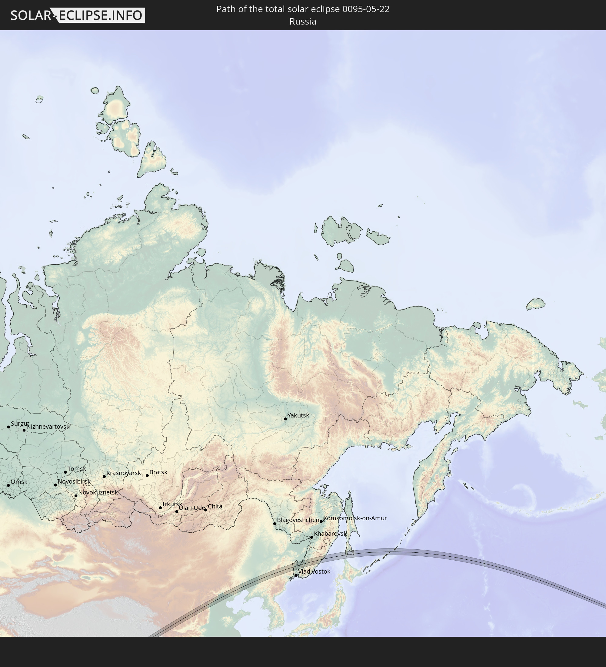 Russia
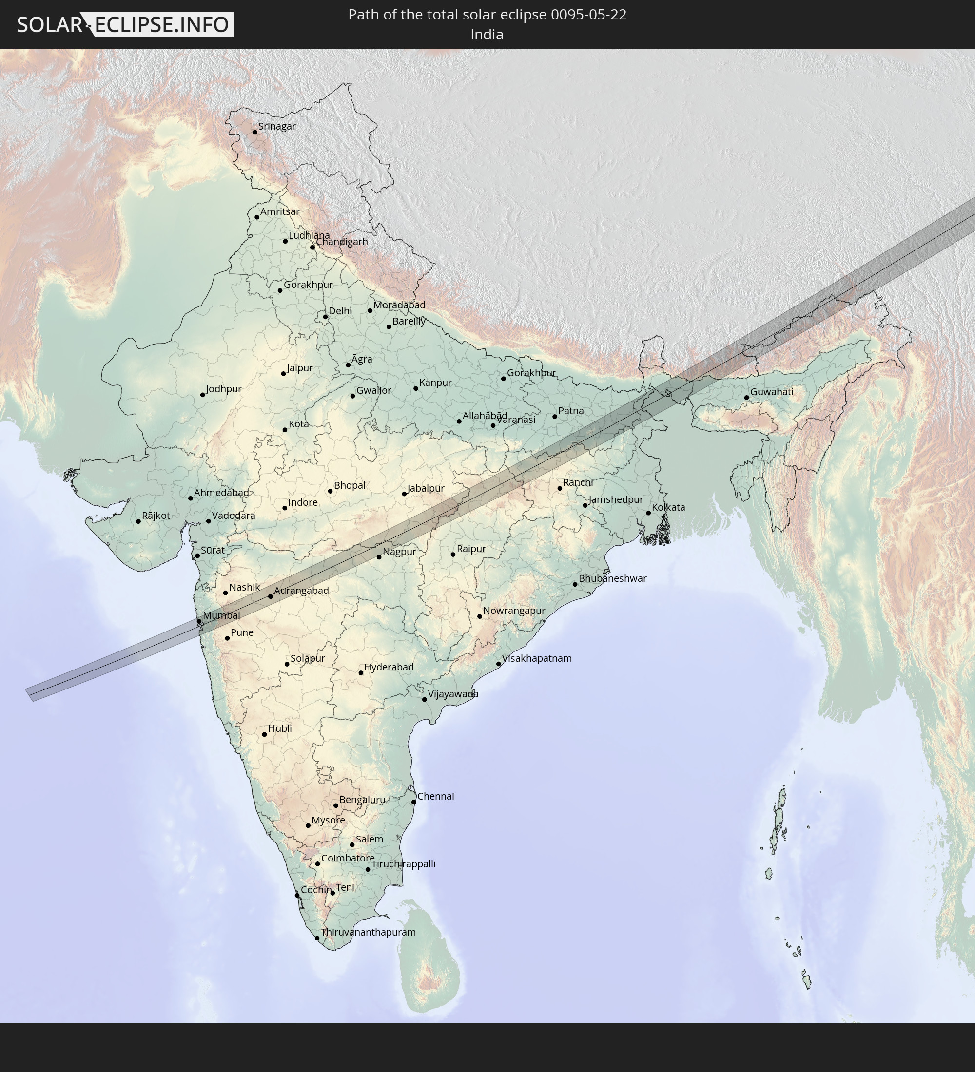 India
India
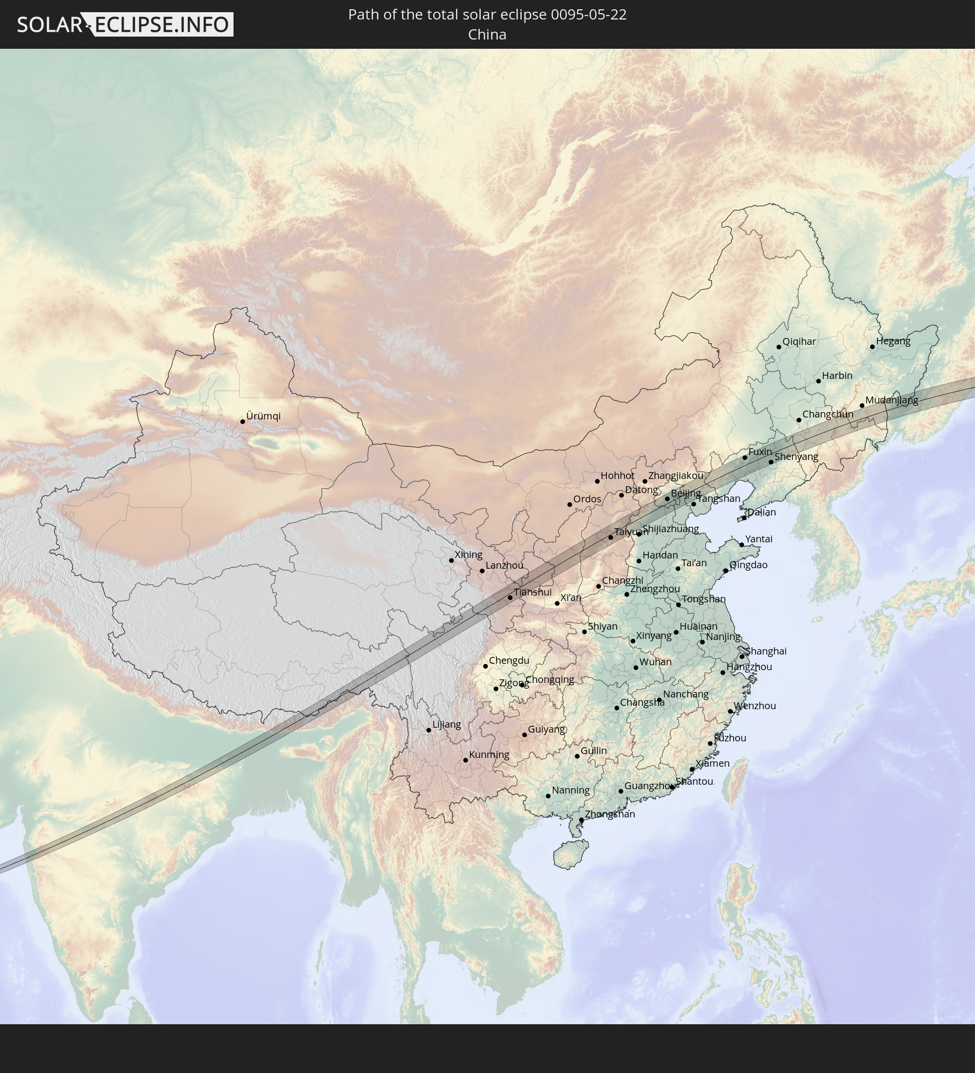 China
China
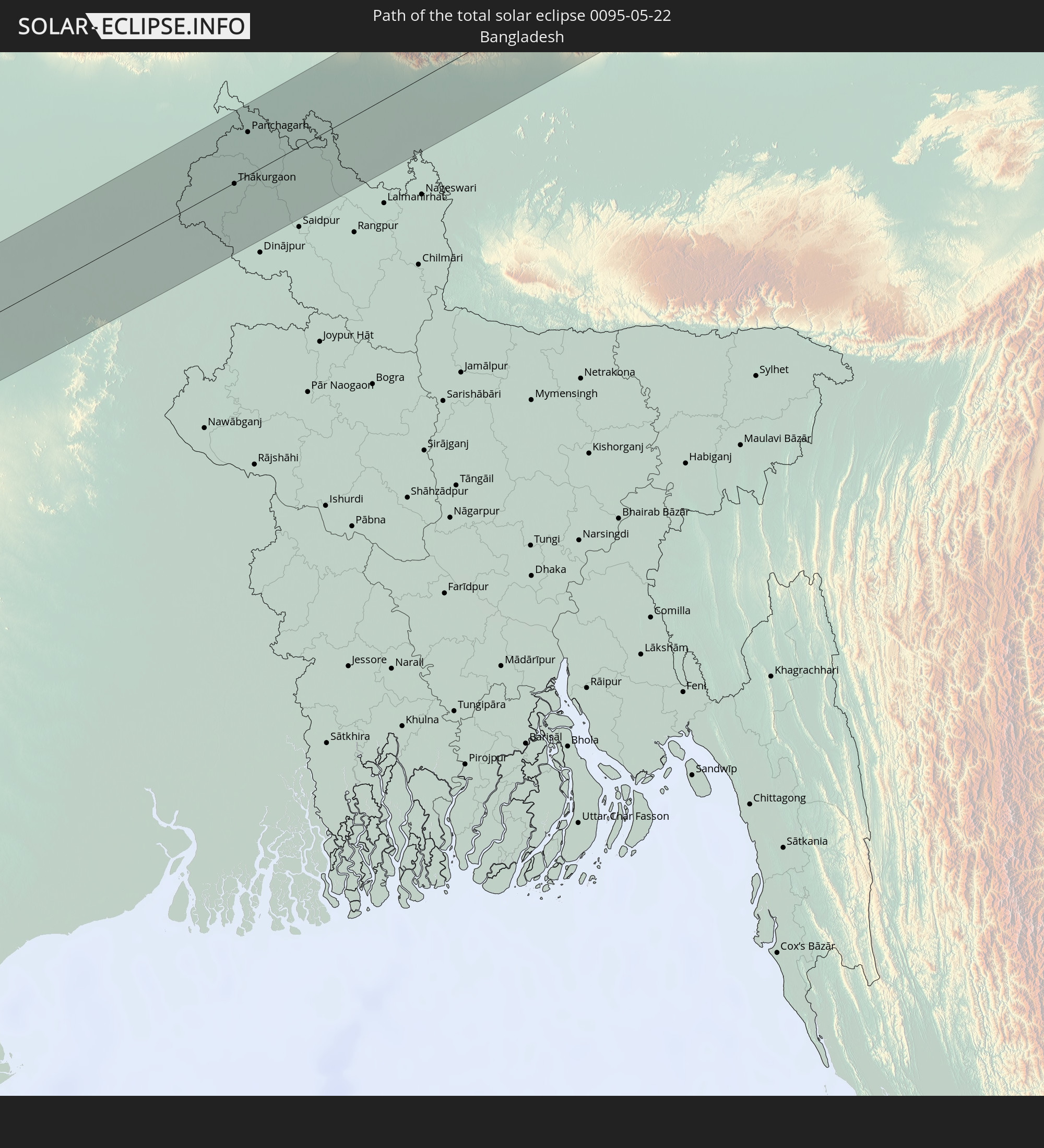 Bangladesh
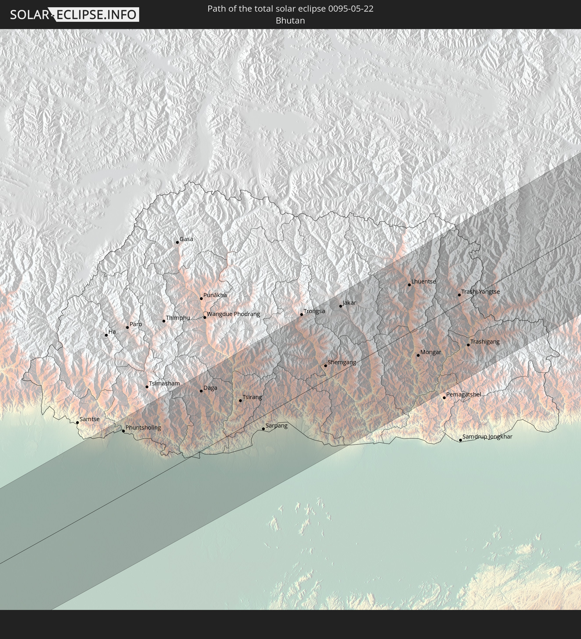 Bhutan
In den folgenden Ländern ist die Sonnenfinsternis partiell zu sehen
 Russia
 United States
 United States Minor Outlying Islands
 Kiribati
 Canada
 Greenland
 Svalbard and Jan Mayen
 Norway
 Sweden
 Åland Islands
 Finland
 Lithuania
 Latvia
 Estonia
 Ukraine
 Belarus
 Georgia
 Iran
Iran
 Azerbaijan
 Kazakhstan
 Turkmenistan
 Uzbekistan
 Afghanistan
 Pakistan
 Tajikistan
 India
India
 Kyrgyzstan
 Maldives
 China
China
 Sri Lanka
 Nepal
Nepal
 Mongolia
 Bangladesh
 Bhutan
 Myanmar
 Indonesia
 Thailand
 Malaysia
 Laos
Laos
 Vietnam
 Cambodia
 Singapore
 Macau
Macau
 Hong Kong
 Brunei
 Taiwan
 Philippines
 Japan
Japan
 North Korea
 South Korea
 Northern Mariana Islands
 Marshall Islands
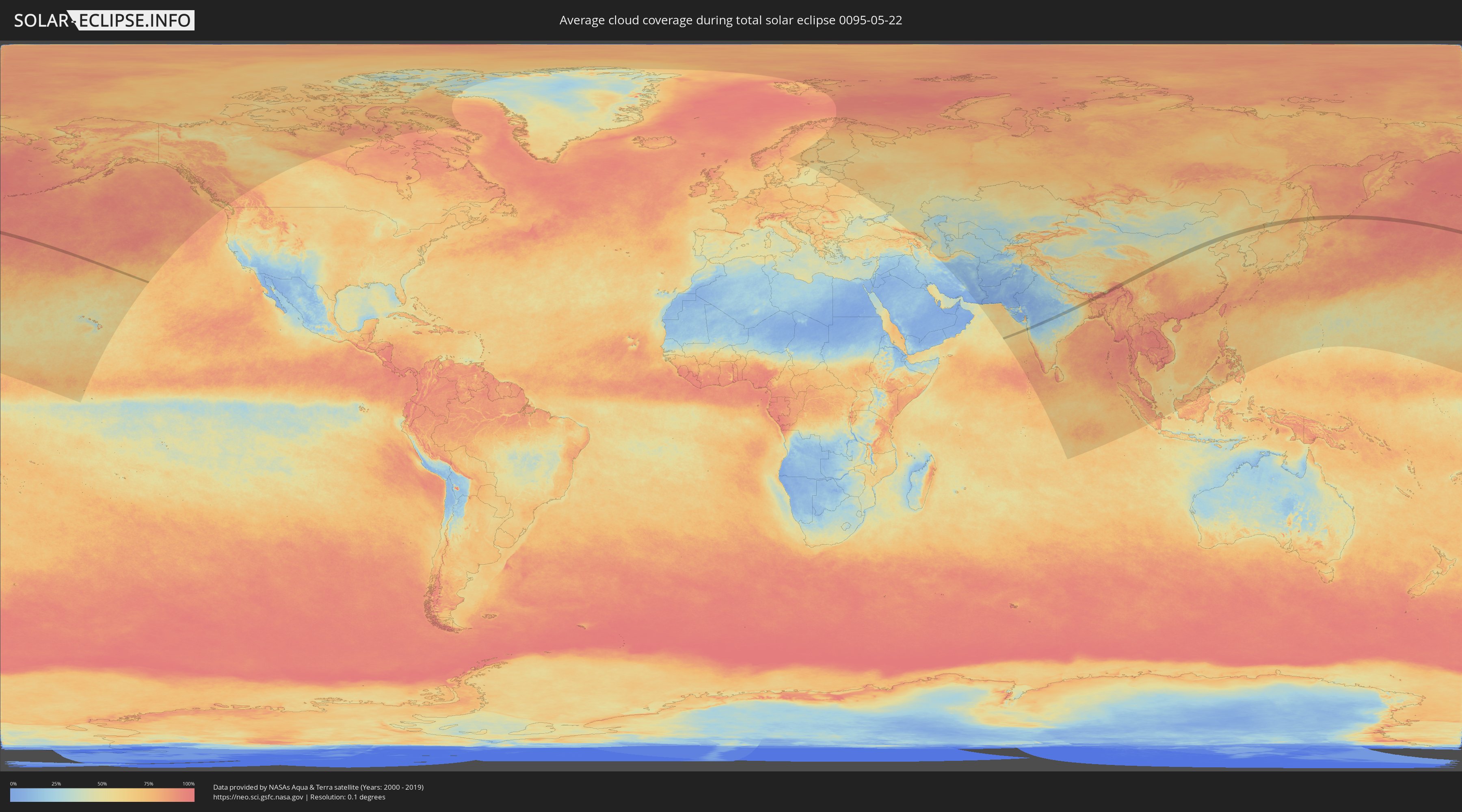
How will be the weather during the total solar eclipse on 05/22/0095?
Where is the best place to see the total solar eclipse of 05/22/0095?
The following maps show the average cloud coverage for the day of the total solar eclipse.
With the help of these maps, it is possible to find the place along the eclipse path, which has the best
chance of a cloudless sky.
Nevertheless, you should consider local circumstances and inform about the weather of your chosen
observation site.
The data is provided by NASAs satellites
AQUA and TERRA.
The cloud maps are averaged over a period of 19 years (2000 - 2019).

Detailed country maps
 Russia
 India
India
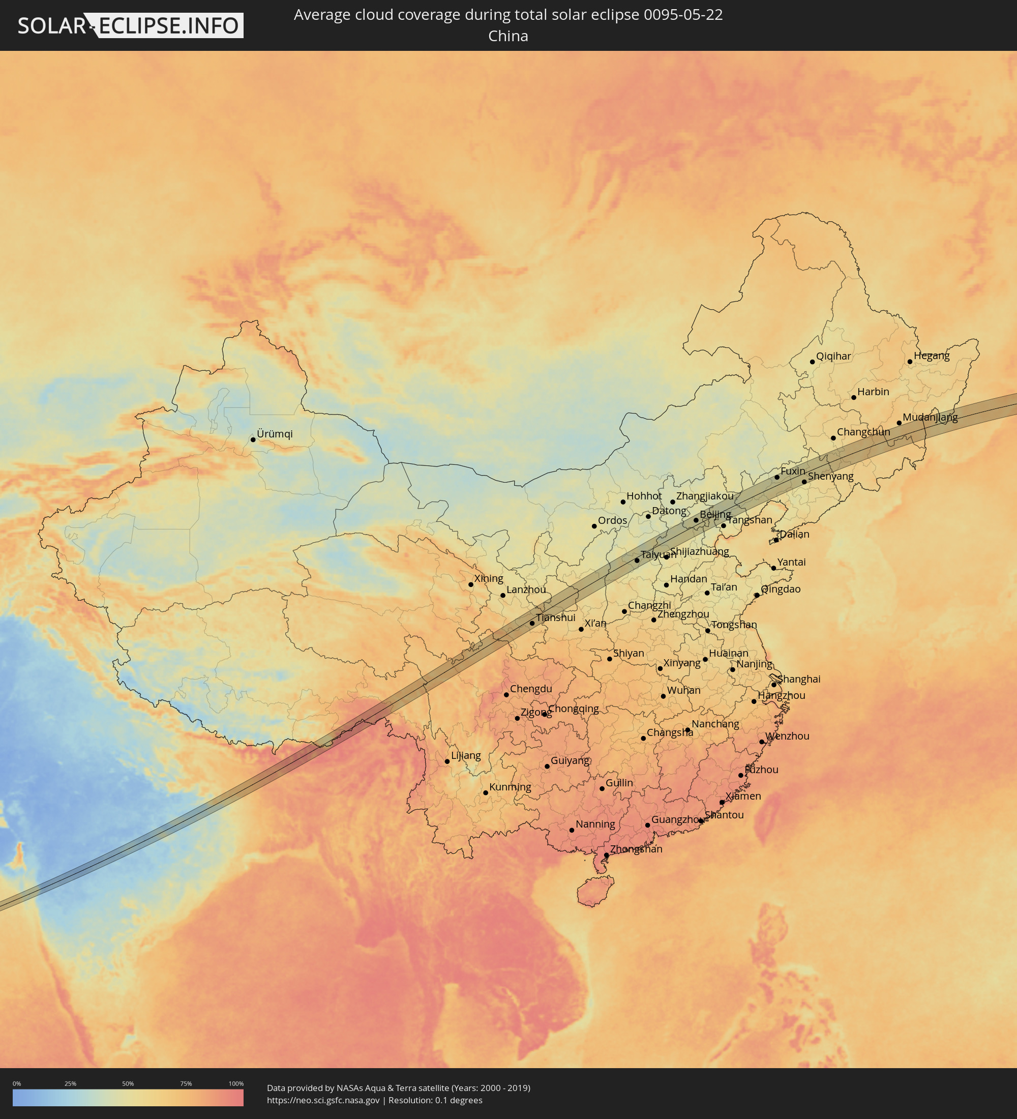 China
China
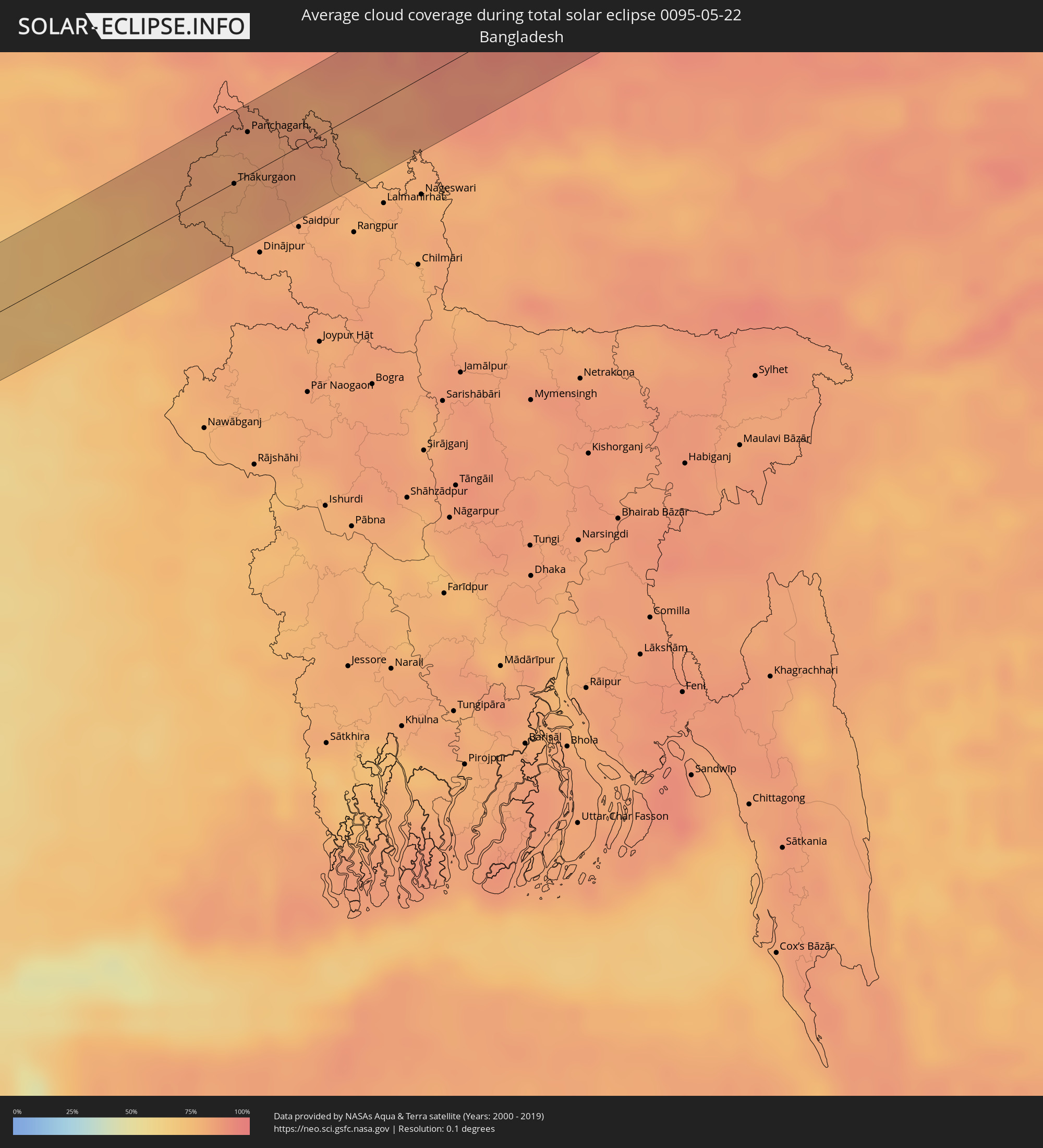 Bangladesh
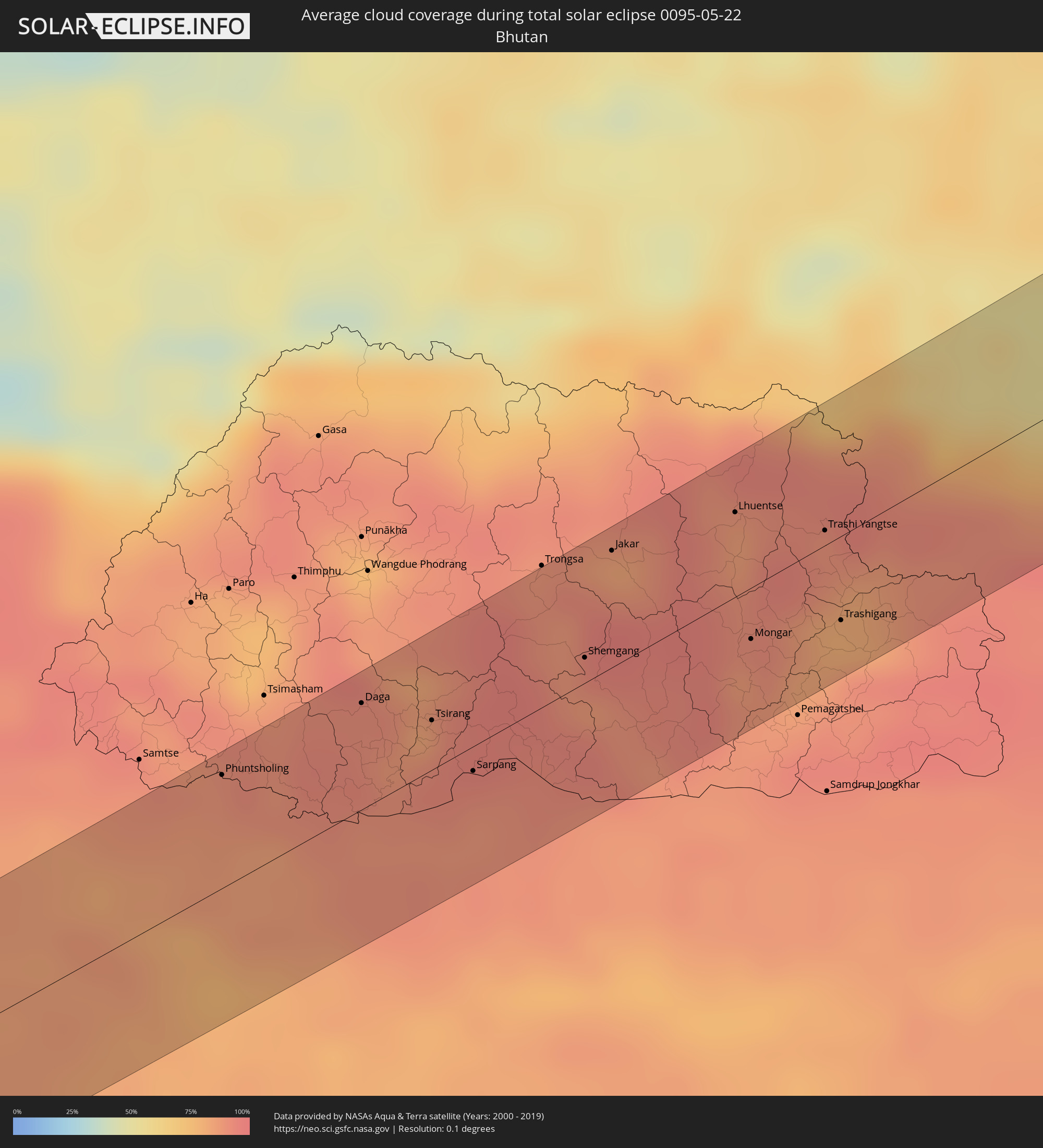 Bhutan
Cities inside the path of the eclipse
The following table shows all locations with a population of more than 5,000 inside the eclipse path. Cities which have more than 100,000 inhabitants are marked bold. A click at the locations opens a detailed map.
| City | Type | Eclipse duration | Local time of max. eclipse | Distance to central line | Ø Cloud coverage |
|
Mumbai, Maharashtra
|
total | - | 06:21:56 UTC+05:21 | 13 km | 43% |
|
Thāne, Maharashtra
|
total | - | 06:22:03 UTC+05:21 | 23 km | 43% |
|
Panvel, Maharashtra
|
total | - | 06:21:49 UTC+05:21 | 5 km | 38% |
|
Kalyān, Maharashtra
|
total | - | 06:22:04 UTC+05:21 | 20 km | 43% |
|
Badlapur, Maharashtra
|
total | - | 06:21:58 UTC+05:21 | 6 km | 43% |
|
Sangamner, Maharashtra
|
total | - | 06:22:15 UTC+05:21 | 8 km | 15% |
|
Kopargaon, Maharashtra
|
total | - | 06:22:33 UTC+05:21 | 29 km | 15% |
|
Aurangabad, Maharashtra
|
total | - | 06:22:27 UTC+05:21 | 8 km | 16% |
|
Sillod, Maharashtra
|
total | - | 06:22:53 UTC+05:21 | 21 km | 14% |
|
Buldāna, Maharashtra
|
total | - | 06:23:05 UTC+05:21 | 21 km | 11% |
|
Chikhli, Maharashtra
|
total | - | 06:22:53 UTC+05:21 | 0 km | 11% |
|
Khāmgaon, Maharashtra
|
total | - | 06:23:16 UTC+05:21 | 23 km | 11% |
|
Shegaon, Maharashtra
|
total | - | 06:23:21 UTC+05:21 | 26 km | 12% |
|
Akola, Maharashtra
|
total | - | 06:23:15 UTC+05:21 | 4 km | 14% |
|
Amrāvati, Maharashtra
|
total | - | 06:23:28 UTC+05:21 | 6 km | 21% |
|
Warud, Maharashtra
|
total | - | 06:24:05 UTC+05:21 | 25 km | 18% |
|
Seoni, Madhya Pradesh
|
total | - | 06:24:49 UTC+05:21 | 29 km | 28% |
|
Bālāghāt, Madhya Pradesh
|
total | - | 06:24:32 UTC+05:21 | 27 km | 18% |
|
Ambikāpur, Chhattisgarh
|
total | - | 06:26:27 UTC+05:21 | 35 km | 22% |
|
Daltonganj, Jharkhand
|
total | - | 06:27:46 UTC+05:21 | 15 km | 30% |
|
Chatra, Jharkhand
|
total | - | 06:28:09 UTC+05:21 | 7 km | 36% |
|
Bagaha, Bihar
|
total | - | 06:28:38 UTC+05:21 | 16 km | 41% |
|
Jumri Tilaiyā, Jharkhand
|
total | - | 06:28:37 UTC+05:21 | 15 km | 35% |
|
Nawāda, Bihar
|
total | - | 06:29:13 UTC+05:21 | 28 km | 62% |
|
Sheikhpura, Bihar
|
total | - | 06:29:38 UTC+05:21 | 39 km | 65% |
|
Luckeesarai, Bihar
|
total | - | 06:29:45 UTC+05:21 | 30 km | 68% |
|
Jamūī, Bihar
|
total | - | 06:29:27 UTC+05:21 | 1 km | 62% |
|
Monghyr, Bihar
|
total | - | 06:30:07 UTC+05:21 | 32 km | 68% |
|
Bhāgalpur, Bihar
|
total | - | 06:30:06 UTC+05:21 | 5 km | 71% |
|
Purnia, Bihar
|
total | - | 06:30:59 UTC+05:21 | 23 km | 73% |
|
Katihar, Bihar
|
total | - | 06:30:42 UTC+05:21 | 5 km | 75% |
|
Sāhibganj, Jharkhand
|
total | - | 06:30:19 UTC+05:21 | 37 km | 70% |
|
Kishanganj, Bihar
|
total | - | 06:31:36 UTC+05:21 | 31 km | 81% |
|
Rāiganj, West Bengal
|
total | - | 06:30:59 UTC+05:21 | 25 km | 77% |
|
Islāmpur, West Bengal
|
total | - | 06:31:54 UTC+05:21 | 36 km | 83% |
|
Kāliyāganj, West Bengal
|
total | - | 06:31:05 UTC+05:21 | 32 km | 82% |
|
Pīrgaaj, Rangpur Division
|
total | - | 07:03:34 UTC+05:53 | 12 km | 78% |
|
Thākurgaon, Rangpur Division
|
total | - | 07:03:51 UTC+05:53 | 1 km | 81% |
|
Panchagarh, Rangpur Division
|
total | - | 07:04:18 UTC+05:53 | 24 km | 83% |
|
Jalpāiguri, West Bengal
|
total | - | 06:32:28 UTC+05:21 | 34 km | 85% |
|
Goyerkāta, West Bengal
|
total | - | 06:32:50 UTC+05:21 | 37 km | 85% |
|
Jaigaon, West Bengal
|
total | - | 06:33:11 UTC+05:21 | 35 km | 87% |
|
Phuntsholing, Chukha District
|
total | - | 06:33:12 UTC+05:21 | 34 km | 89% |
|
Koch Bihār, West Bengal
|
total | - | 06:32:29 UTC+05:21 | 19 km | 76% |
|
Daga, Dagana District
|
total | - | 07:11:09 UTC+05:58 | 32 km | 91% |
|
Tsirang, Chirang
|
total | - | 07:11:11 UTC+05:58 | 15 km | 89% |
|
Sarpang, Geylegphug
|
total | - | 07:11:01 UTC+05:58 | 7 km | 92% |
|
Shemgang, Shemgang
|
total | - | 07:11:42 UTC+05:58 | 8 km | 87% |
|
Jakar, Bumthang
|
total | - | 07:12:13 UTC+05:58 | 35 km | 88% |
|
Lhuentse, Lhuntse District
|
total | - | 07:12:36 UTC+05:58 | 25 km | 85% |
|
Mongar, Mongar District
|
total | - | 07:12:04 UTC+05:58 | 15 km | 86% |
|
Trashi Yangtse, Trashi Yangste
|
total | - | 07:12:40 UTC+05:58 | 4 km | 90% |
|
Trashigang, Tashigang
|
total | - | 07:12:18 UTC+05:58 | 25 km | 91% |
|
Tianshui, Gansu
|
total | - | 09:36:37 UTC+08:00 | 28 km | 64% |
|
Beidao, Gansu
|
total | - | 09:36:46 UTC+08:00 | 36 km | 61% |
|
Pingliang, Gansu
|
total | - | 09:39:18 UTC+08:00 | 19 km | 57% |
|
Taiyuan, Shanxi
|
total | - | 09:50:47 UTC+08:00 | 21 km | 45% |
|
Yuci, Shanxi
|
total | - | 09:50:43 UTC+08:00 | 47 km | 45% |
|
Xinzhou, Shanxi
|
total | - | 09:51:53 UTC+08:00 | 24 km | 47% |
|
Baoding, Hebei
|
total | - | 09:56:41 UTC+08:00 | 48 km | 51% |
|
Fangshan, Beijing
|
total | - | 09:58:46 UTC+08:00 | 14 km | 49% |
|
Mentougou, Beijing
|
total | - | 09:59:18 UTC+08:00 | 34 km | 48% |
|
Liangxiang, Beijing
|
total | - | 09:59:03 UTC+08:00 | 13 km | 48% |
|
Daxing, Beijing
|
total | - | 09:59:22 UTC+08:00 | 6 km | 48% |
|
Beijing, Beijing
|
total | - | 09:59:44 UTC+08:00 | 19 km | 47% |
|
Shunyi, Beijing
|
total | - | 10:00:27 UTC+08:00 | 31 km | 46% |
|
Tongzhou, Beijing
|
total | - | 10:00:08 UTC+08:00 | 9 km | 48% |
|
Langfang, Hebei
|
total | - | 09:59:35 UTC+08:00 | 32 km | 46% |
|
Lingyuan, Liaoning
|
total | - | 10:06:33 UTC+08:00 | 37 km | 46% |
|
Yebaishou, Liaoning
|
total | - | 10:07:10 UTC+08:00 | 44 km | 48% |
|
Chaoyang, Liaoning
|
total | - | 10:08:47 UTC+08:00 | 32 km | 49% |
|
Nanpiao, Liaoning
|
total | - | 10:08:37 UTC+08:00 | 26 km | 52% |
|
Beipiao, Liaoning
|
total | - | 10:09:38 UTC+08:00 | 43 km | 47% |
|
Jinzhou, Liaoning
|
total | - | 10:09:18 UTC+08:00 | 39 km | 52% |
|
Fuxin, Liaoning
|
total | - | 10:11:26 UTC+08:00 | 35 km | 47% |
|
Heishan, Liaoning
|
total | - | 10:11:47 UTC+08:00 | 14 km | 52% |
|
Xinmin, Liaoning
|
total | - | 10:13:26 UTC+08:00 | 7 km | 53% |
|
Shenyang, Liaoning
|
total | - | 10:14:16 UTC+08:00 | 48 km | 49% |
|
Hushitai, Liaoning
|
total | - | 10:14:35 UTC+08:00 | 36 km | 51% |
|
Dongling, Liaoning
|
total | - | 10:14:33 UTC+08:00 | 50 km | 51% |
|
Tieling, Liaoning
|
total | - | 10:15:38 UTC+08:00 | 10 km | 52% |
|
Kaiyuan, Liaoning
|
total | - | 10:16:17 UTC+08:00 | 8 km | 54% |
|
Changtu, Liaoning
|
total | - | 10:16:41 UTC+08:00 | 32 km | 52% |
|
Liaoyuan, Jilin
|
total | - | 10:18:42 UTC+08:00 | 12 km | 57% |
|
Dongfeng, Jilin
|
total | - | 10:19:05 UTC+08:00 | 26 km | 58% |
|
Meihekou, Jilin
|
total | - | 10:19:15 UTC+08:00 | 43 km | 58% |
|
Chaoyang, Jilin
|
total | - | 10:20:03 UTC+08:00 | 40 km | 60% |
|
Panshi, Jilin
|
total | - | 10:20:26 UTC+08:00 | 12 km | 62% |
|
Huinan, Jilin
|
total | - | 10:20:27 UTC+08:00 | 51 km | 61% |
|
Huadian, Jilin
|
total | - | 10:21:44 UTC+08:00 | 30 km | 58% |
|
Minzhu, Jilin
|
total | - | 10:23:39 UTC+08:00 | 32 km | 59% |
|
Dunhua, Jilin
|
total | - | 10:24:59 UTC+08:00 | 29 km | 60% |
|
Dashitou, Jilin
|
total | - | 10:25:25 UTC+08:00 | 44 km | 59% |
|
Pogranichnyy, Primorskiy
|
total | - | 11:19:26 UTC+08:47 | 0 km | 64% |
|
Lipovtsy, Primorskiy
|
total | - | 11:19:55 UTC+08:47 | 30 km | 61% |
|
Kamen’-Rybolov, Primorskiy
|
total | - | 11:20:59 UTC+08:47 | 20 km | 59% |
|
Khorol’, Primorskiy
|
total | - | 11:20:47 UTC+08:47 | 14 km | 60% |
|
Yaroslavskiy, Primorskiy
|
total | - | 11:20:53 UTC+08:47 | 44 km | 58% |
|
Chernigovka, Primorskiy
|
total | - | 11:21:40 UTC+08:47 | 35 km | 62% |
|
Spasskoye, Primorskiy
|
total | - | 11:22:20 UTC+08:47 | 11 km | 59% |
|
Spassk-Dal’niy, Primorskiy
|
total | - | 11:22:22 UTC+08:47 | 13 km | 59% |
|
Kirovskiy, Primorskiy
|
total | - | 11:24:02 UTC+08:47 | 26 km | 58% |
|
Gornyye Klyuchi, Primorskiy
|
total | - | 11:24:09 UTC+08:47 | 42 km | 56% |
|
Korsakov, Sakhalin
|
total | - | 13:09:46 UTC+10:14 | 51 km | 71% |