Hybrid solar eclipse of 10/14/0125
| Day of week: | Sunday |
| Maximum duration of eclipse: | 01m16s |
| Maximum width of eclipse path: | 58 km |
| Saros cycle: | 84 |
| Coverage: | 100% |
| Magnitude: | 1.0153 |
| Gamma: | -0.4532 |
Wo kann man die Sonnenfinsternis vom 10/14/0125 sehen?

Die Sonnenfinsternis am 10/14/0125 kann man in 41 Ländern als partielle Sonnenfinsternis beobachten.
Der Finsternispfad verläuft durch ein Land. Nur in diesem Land ist sie als hybrid Sonnenfinsternis zu sehen.
In den folgenden Ländern ist die Sonnenfinsternis hybrid zu sehen
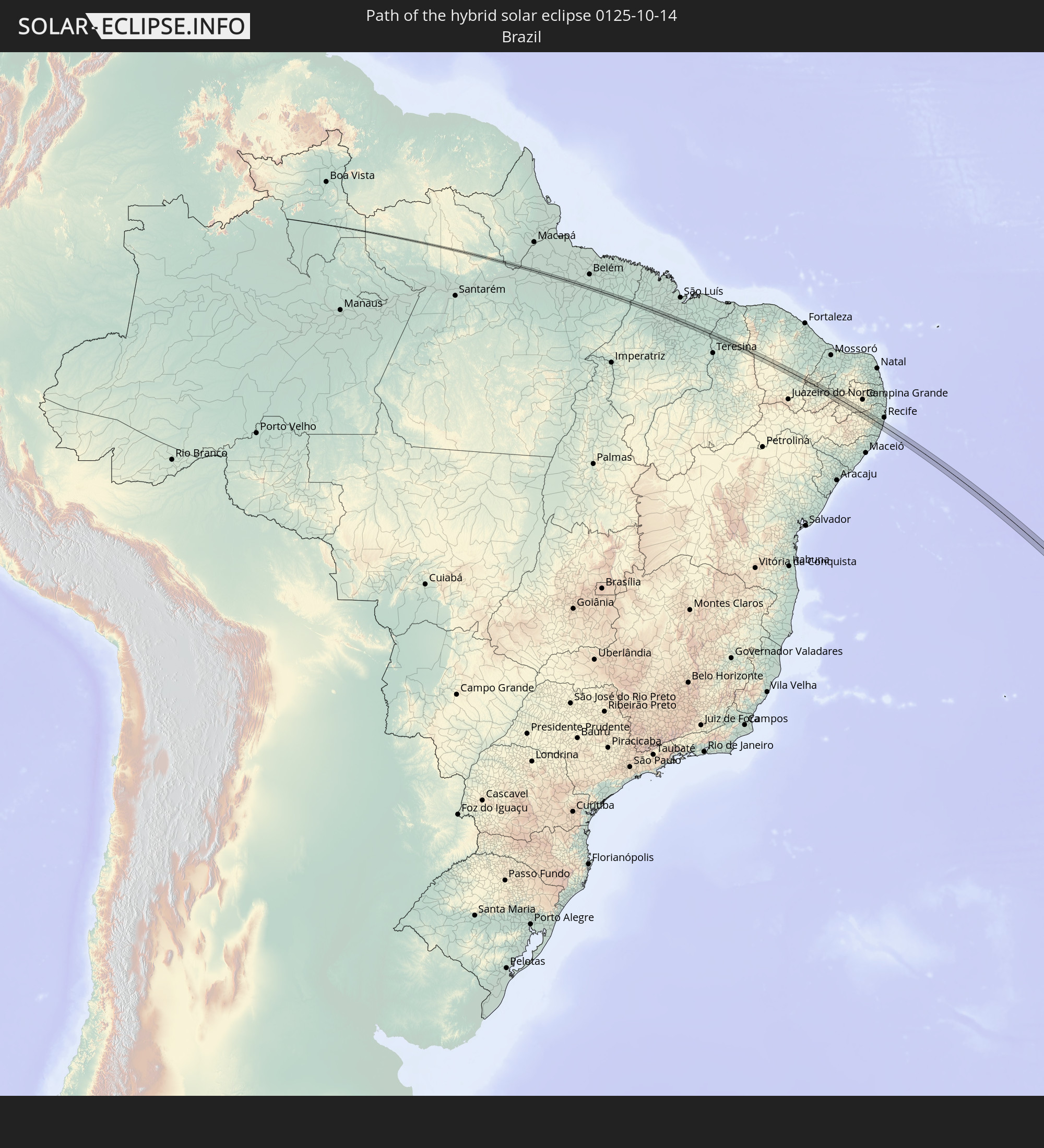 Brazil
In den folgenden Ländern ist die Sonnenfinsternis partiell zu sehen
 Antarctica
 Chile
Chile
 Peru
Peru
 Brazil
 Argentina
 Venezuela
 Bolivia
 Paraguay
 Falkland Islands
 Guyana
 Uruguay
 Suriname
 French Guiana
 South Georgia and the South Sandwich Islands
 Cabo Verde
 Senegal
 Mauritania
 The Gambia
 Guinea-Bissau
 Guinea
 Saint Helena, Ascension and Tristan da Cunha
 Sierra Leone
 Mali
Mali
 Liberia
 Ivory Coast
 Burkina Faso
 Ghana
Ghana
 Bouvet Island
 Equatorial Guinea
 Angola
 Namibia
 South Africa
 Botswana
 Zambia
 Zimbabwe
 Lesotho
 Mozambique
 Swaziland
 French Southern and Antarctic Lands
 Madagascar
 Heard Island and McDonald Islands
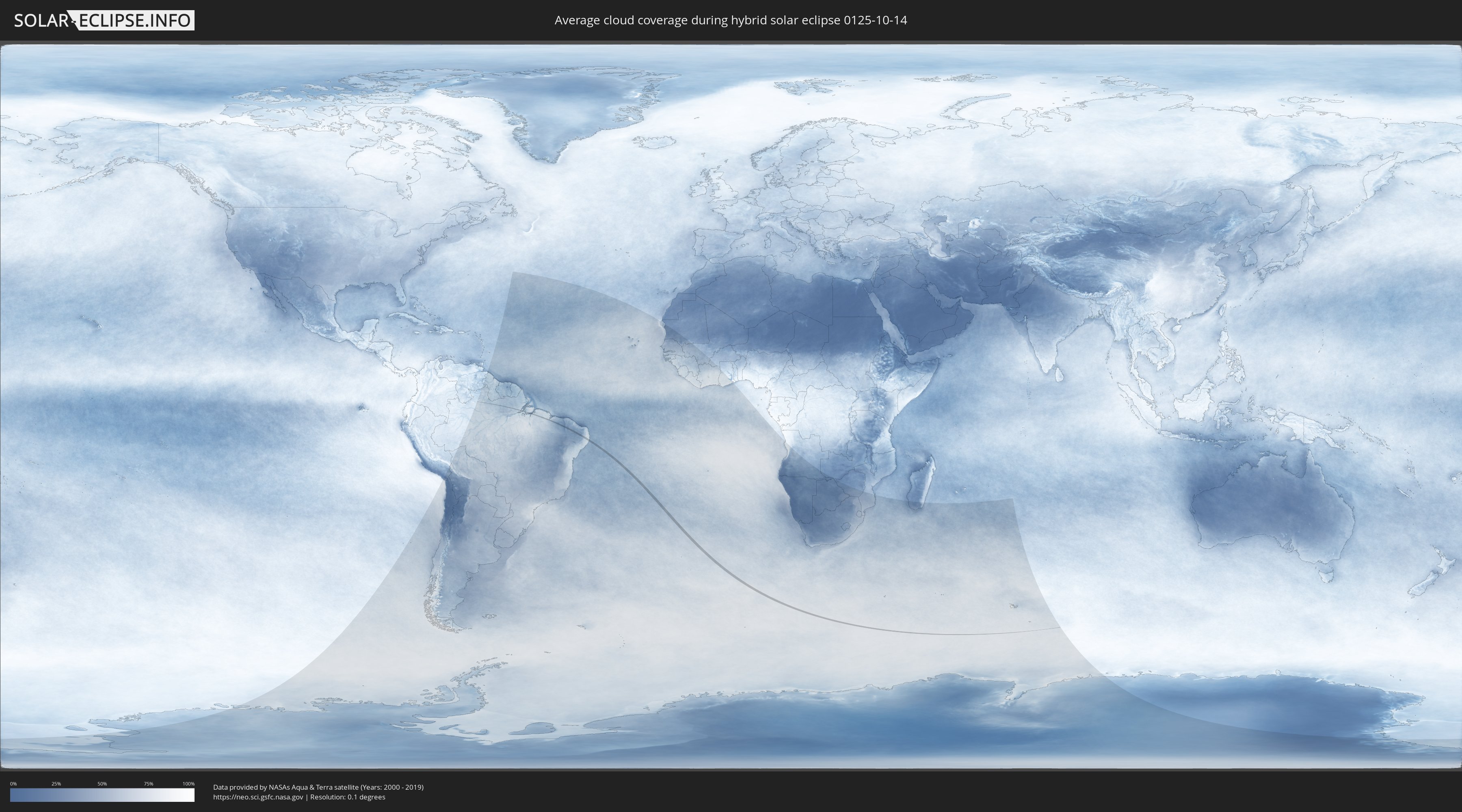
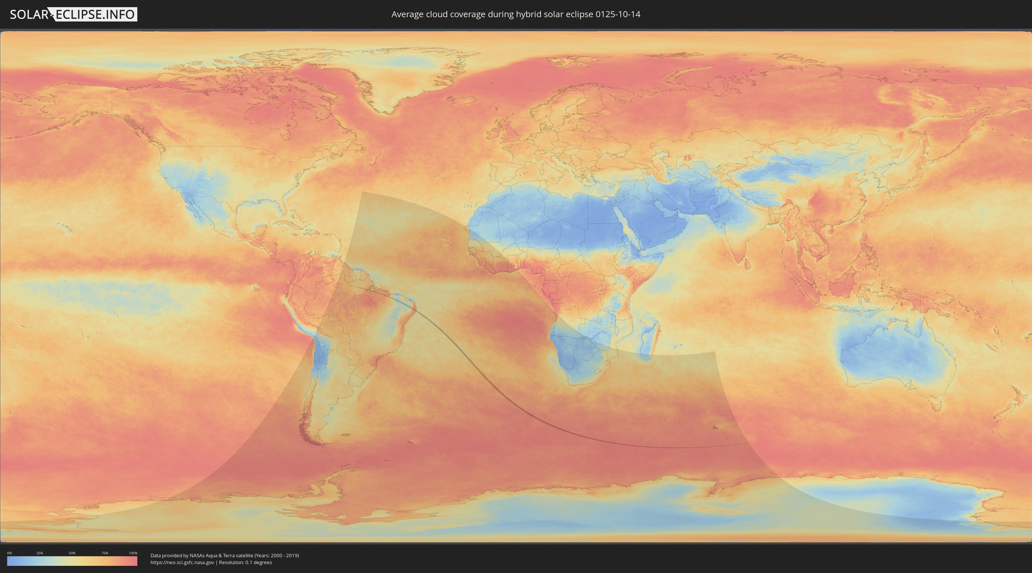
How will be the weather during the hybrid solar eclipse on 10/14/0125?
Where is the best place to see the hybrid solar eclipse of 10/14/0125?
The following maps show the average cloud coverage for the day of the hybrid solar eclipse.
With the help of these maps, it is possible to find the place along the eclipse path, which has the best
chance of a cloudless sky.
Nevertheless, you should consider local circumstances and inform about the weather of your chosen
observation site.
The data is provided by NASAs satellites
AQUA and TERRA.
The cloud maps are averaged over a period of 19 years (2000 - 2019).
Detailed country maps
 Brazil
Cities inside the path of the eclipse
The following table shows all locations with a population of more than 5,000 inside the eclipse path. Cities which have more than 100,000 inhabitants are marked bold. A click at the locations opens a detailed map.
| City | Type | Eclipse duration | Local time of max. eclipse | Distance to central line | Ø Cloud coverage |
|
Igarapé Miri, Pará
|
total | - | 06:48:45 UTC-03:13 | 5 km | 79% |
|
Penalva, Maranhão
|
total | - | 07:31:33 UTC-02:34 | 2 km | 73% |
|
Viana, Maranhão
|
total | - | 07:31:31 UTC-02:34 | 12 km | 78% |
|
Vitória do Mearim, Maranhão
|
total | - | 07:31:53 UTC-02:34 | 7 km | 75% |
|
Arari, Maranhão
|
total | - | 07:31:55 UTC-02:34 | 3 km | 71% |
|
Cantanhede, Maranhão
|
total | - | 07:32:19 UTC-02:34 | 4 km | 66% |
|
Pirapemas, Maranhão
|
total | - | 07:32:30 UTC-02:34 | 8 km | 66% |
|
Santa Rita, Maranhão
|
total | - | 07:32:50 UTC-02:34 | 6 km | 57% |
|
Coelho Neto, Maranhão
|
total | - | 07:33:45 UTC-02:34 | 9 km | 46% |
|
Miguel Alves, Piauí
|
total | - | 07:33:41 UTC-02:34 | 5 km | 45% |
|
Crateús, Ceará
|
total | - | 07:36:14 UTC-02:34 | 6 km | 39% |
|
Várzea Alegre, Ceará
|
total | - | 07:36:38 UTC-02:34 | 3 km | 36% |
|
Independência, Ceará
|
total | - | 07:36:45 UTC-02:34 | 2 km | 35% |
|
Mombaça, Ceará
|
total | - | 07:37:39 UTC-02:34 | 2 km | 42% |
|
Orós, Ceará
|
total | - | 07:38:49 UTC-02:34 | 11 km | 39% |
|
Uiraúna, Paraíba
|
total | - | 07:39:33 UTC-02:34 | 12 km | 36% |
|
Serra Branca, Paraíba
|
total | - | 07:39:40 UTC-02:34 | 5 km | 37% |
|
Pombal, Paraíba
|
total | - | 07:40:20 UTC-02:34 | 3 km | 38% |
|
Patos, Paraíba
|
total | - | 07:41:04 UTC-02:34 | 0 km | 34% |
|
Teixeira, Paraíba
|
total | - | 07:41:24 UTC-02:34 | 17 km | 40% |
|
Desterro, Paraíba
|
total | - | 07:41:37 UTC-02:34 | 15 km | 45% |
|
Taperoá, Paraíba
|
total | - | 07:41:40 UTC-02:34 | 8 km | 51% |
|
Taquaritinga do Norte, Pernambuco
|
total | - | 07:57:44 UTC-02:19 | 14 km | 81% |
|
Surubim, Pernambuco
|
total | - | 07:57:50 UTC-02:19 | 9 km | 82% |
|
Cumaru, Pernambuco
|
total | - | 07:58:09 UTC-02:19 | 4 km | 85% |
|
João Alfredo, Pernambuco
|
total | - | 07:57:59 UTC-02:19 | 17 km | 87% |
|
Passira, Pernambuco
|
total | - | 07:58:13 UTC-02:19 | 4 km | 87% |
|
Gravatá, Pernambuco
|
total | - | 07:58:34 UTC-02:19 | 15 km | 81% |
|
Chã Grande, Pernambuco
|
total | - | 07:58:42 UTC-02:19 | 12 km | 84% |
|
Pombos, Pernambuco
|
total | - | 07:58:36 UTC-02:19 | 1 km | 84% |
|
Feira Nova, Pernambuco
|
total | - | 07:58:17 UTC-02:19 | 19 km | 83% |
|
Glória do Goitá, Pernambuco
|
total | - | 07:58:27 UTC-02:19 | 20 km | 83% |
|
Vitória de Santo Antão, Pernambuco
|
total | - | 07:58:38 UTC-02:19 | 9 km | 86% |
|
Escada, Pernambuco
|
total | - | 07:59:05 UTC-02:19 | 10 km | 85% |
|
Moreno, Pernambuco
|
total | - | 07:58:47 UTC-02:19 | 21 km | 83% |
|
Ipojuca, Pernambuco
|
total | - | 07:59:16 UTC-02:19 | 4 km | 81% |
|
Cabo, Pernambuco
|
total | - | 07:59:06 UTC-02:19 | 9 km | 70% |
|
Jaboatão, Pernambuco
|
total | - | 07:58:57 UTC-02:19 | 20 km | 73% |