Total solar eclipse of 02/06/0129
| Day of week: | Sunday |
| Maximum duration of eclipse: | 03m10s |
| Maximum width of eclipse path: | 144 km |
| Saros cycle: | 81 |
| Coverage: | 100% |
| Magnitude: | 1.0354 |
| Gamma: | 0.582 |
Wo kann man die Sonnenfinsternis vom 02/06/0129 sehen?

Die Sonnenfinsternis am 02/06/0129 kann man in 87 Ländern als partielle Sonnenfinsternis beobachten.
Der Finsternispfad verläuft durch 9 Länder. Nur in diesen Ländern ist sie als total Sonnenfinsternis zu sehen.
In den folgenden Ländern ist die Sonnenfinsternis total zu sehen
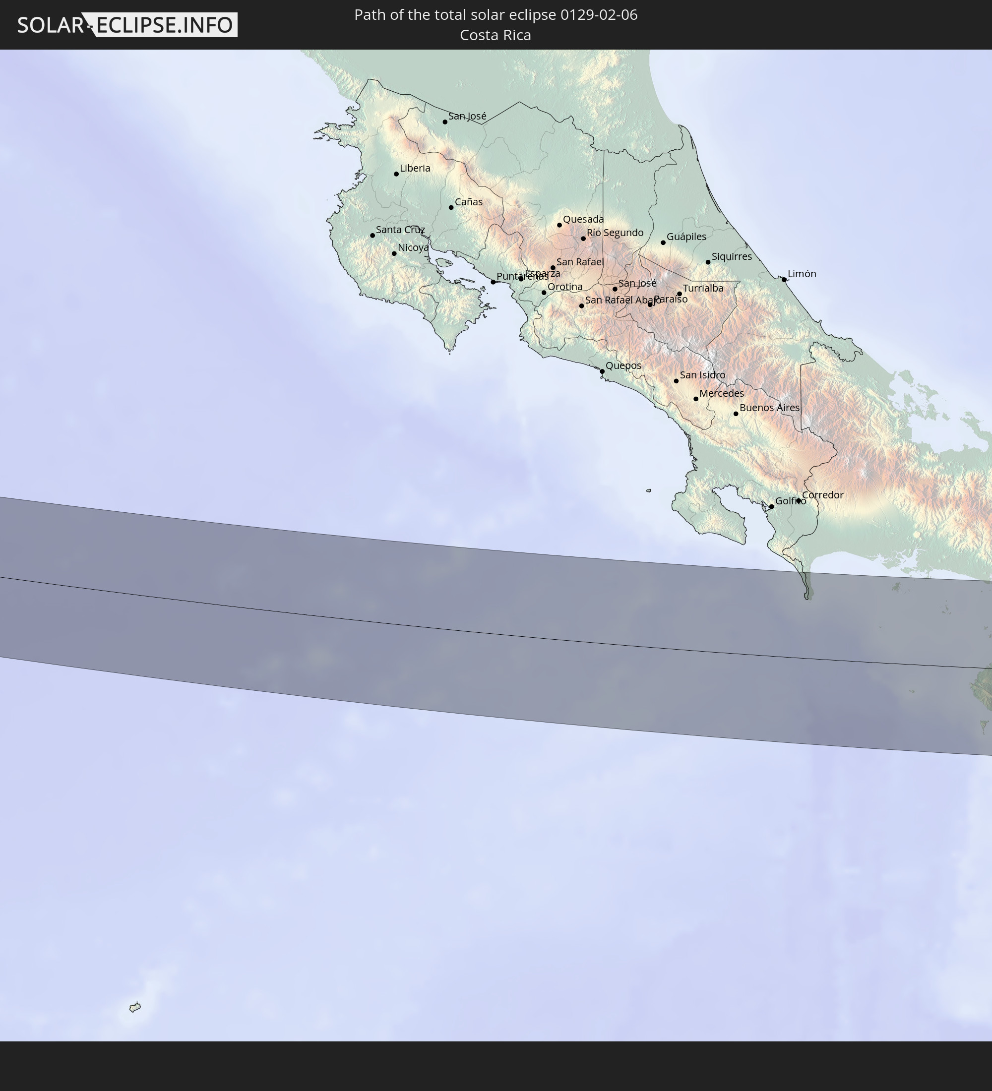 Costa Rica
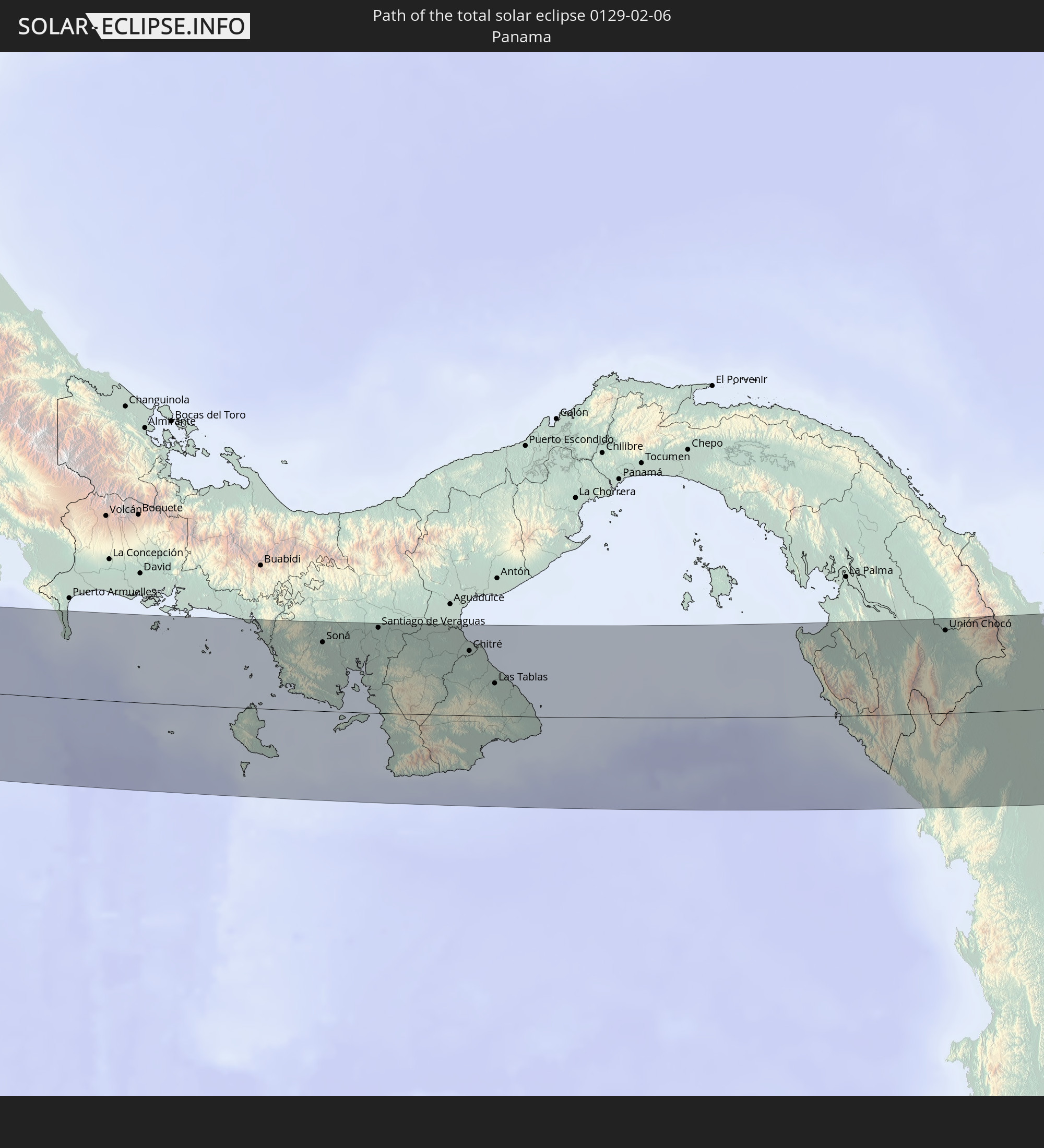 Panama
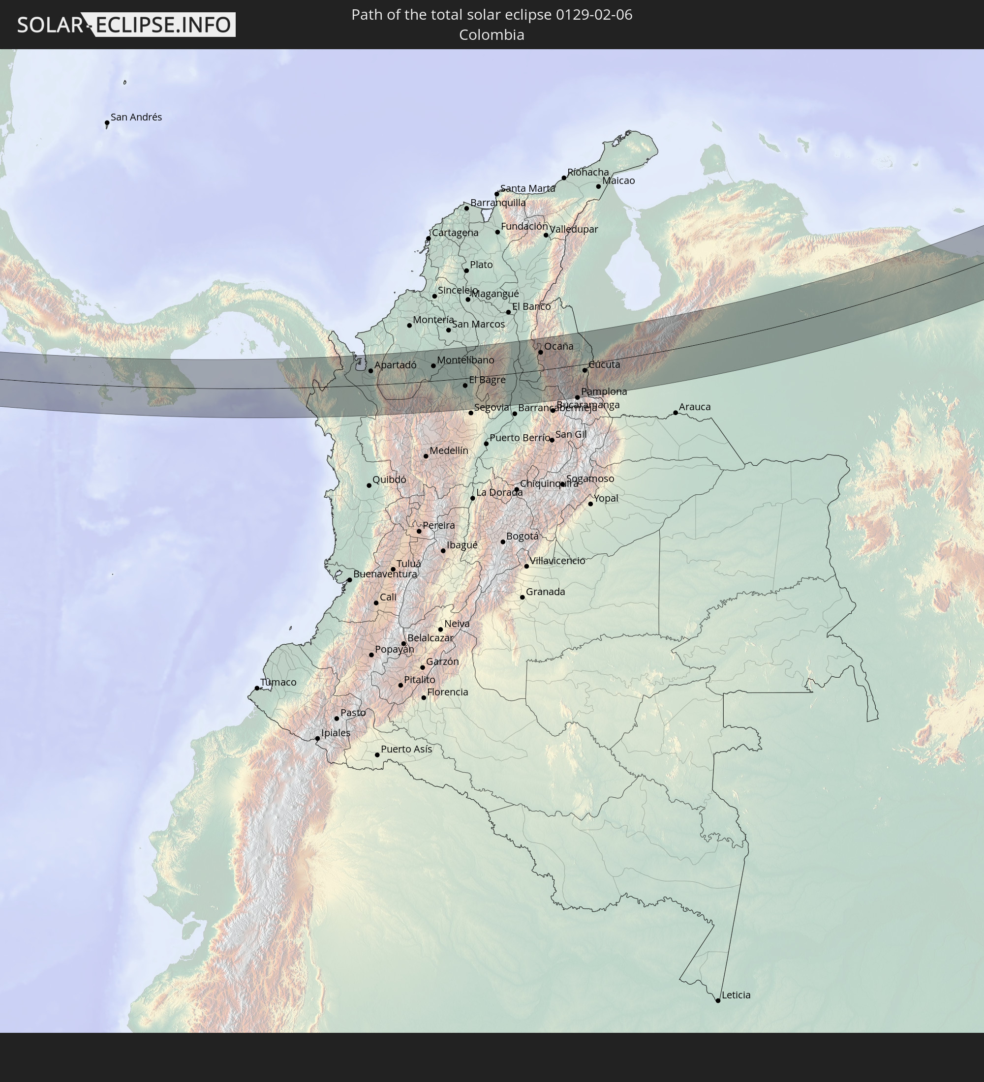 Colombia
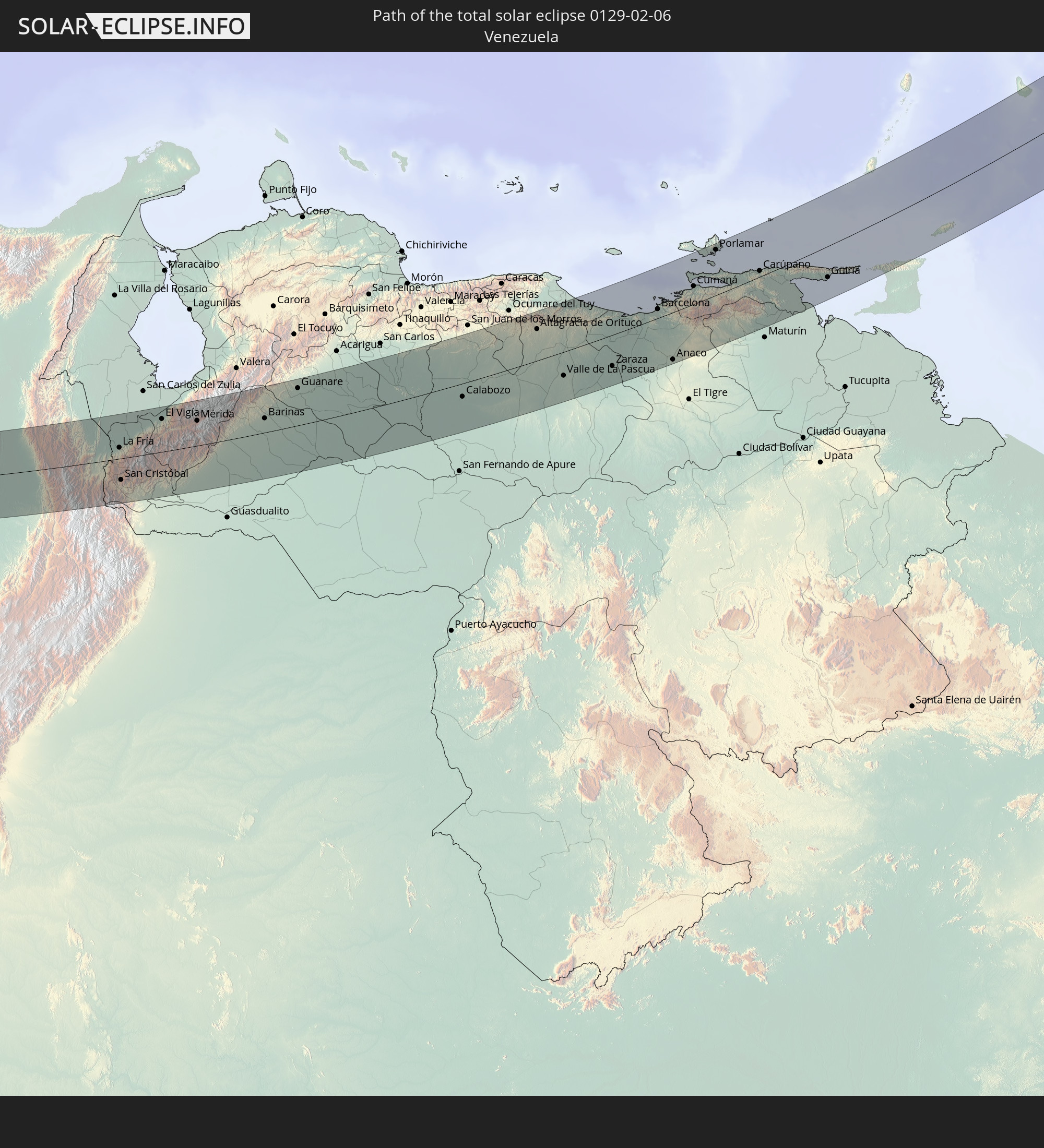 Venezuela
 Trinidad and Tobago
 Grenada
 Barbados
 Portugal
 United Kingdom
In den folgenden Ländern ist die Sonnenfinsternis partiell zu sehen
 United States
 United States Minor Outlying Islands
 Canada
 Mexico
 Chile
Chile
 Greenland
 Guatemala
 Ecuador
 El Salvador
 Honduras
 Belize
 Nicaragua
 Costa Rica
 Cuba
Cuba
 Panama
 Colombia
 Cayman Islands
 Peru
Peru
 The Bahamas
 Jamaica
 Haiti
Haiti
 Brazil
 Argentina
 Venezuela
 Turks and Caicos Islands
 Dominican Republic
 Aruba
Aruba
 Bolivia
 Puerto Rico
 United States Virgin Islands
 Bermuda
 British Virgin Islands
 Anguilla
 Collectivity of Saint Martin
 Saint Barthélemy
 Saint Kitts and Nevis
 Paraguay
 Antigua and Barbuda
 Montserrat
 Trinidad and Tobago
 Guadeloupe
 Grenada
 Dominica
 Saint Vincent and the Grenadines
 Guyana
 Martinique
 Saint Lucia
 Barbados
 Suriname
 Saint Pierre and Miquelon
 French Guiana
 Portugal
 Cabo Verde
 Iceland
 Spain
Spain
 Senegal
 Mauritania
 The Gambia
 Guinea-Bissau
 Guinea
 Sierra Leone
 Morocco
 Mali
Mali
 Republic of Ireland
 Algeria
 United Kingdom
 Faroe Islands
 Gibraltar
 France
 Isle of Man
 Guernsey
 Jersey
 Niger
Niger
 Andorra
 Belgium
 Netherlands
 Luxembourg
 Germany
 Switzerland
 Italy
Italy
 Monaco
 Tunisia
 Libya
Libya
 Liechtenstein
 Austria
 Vatican City
 Malta
Malta
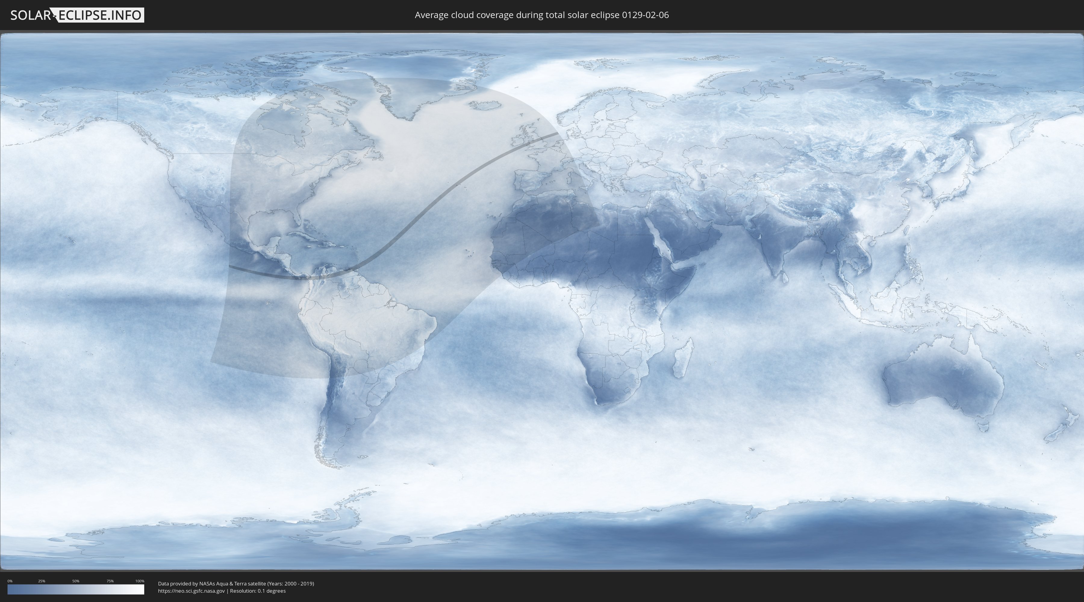
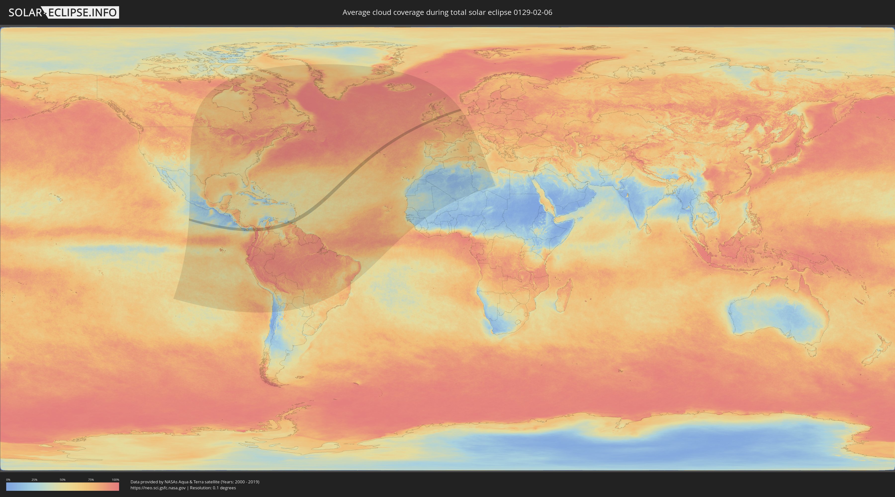
How will be the weather during the total solar eclipse on 02/06/0129?
Where is the best place to see the total solar eclipse of 02/06/0129?
The following maps show the average cloud coverage for the day of the total solar eclipse.
With the help of these maps, it is possible to find the place along the eclipse path, which has the best
chance of a cloudless sky.
Nevertheless, you should consider local circumstances and inform about the weather of your chosen
observation site.
The data is provided by NASAs satellites
AQUA and TERRA.
The cloud maps are averaged over a period of 19 years (2000 - 2019).
Detailed country maps
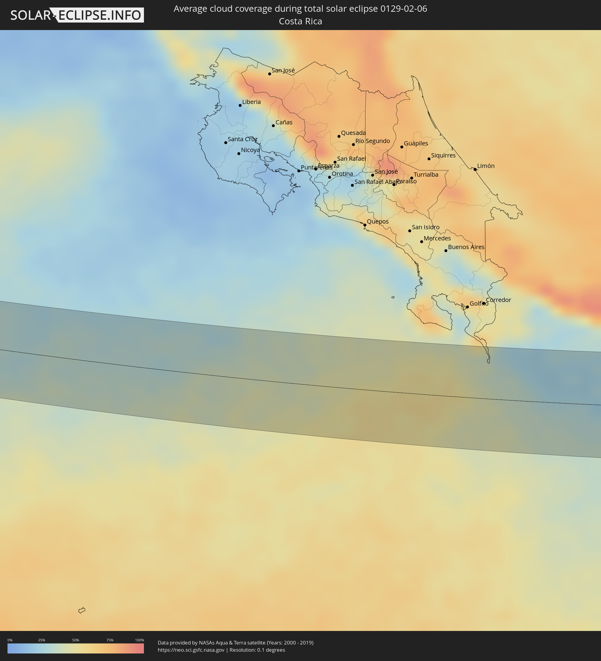 Costa Rica
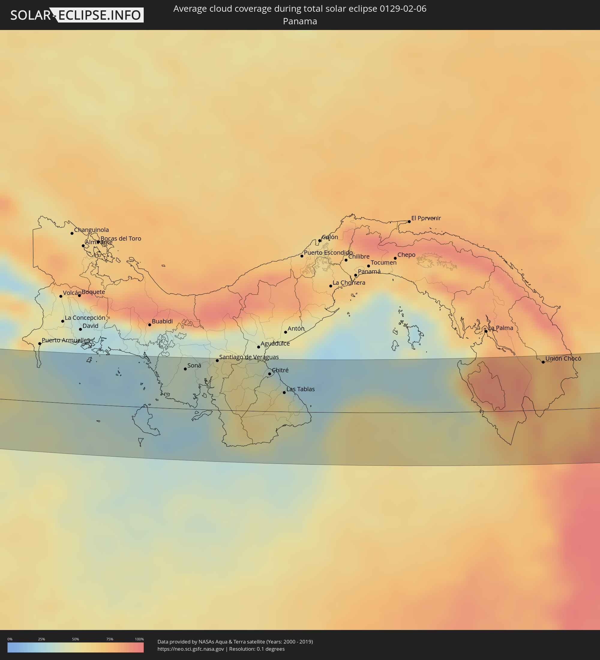 Panama
 Colombia
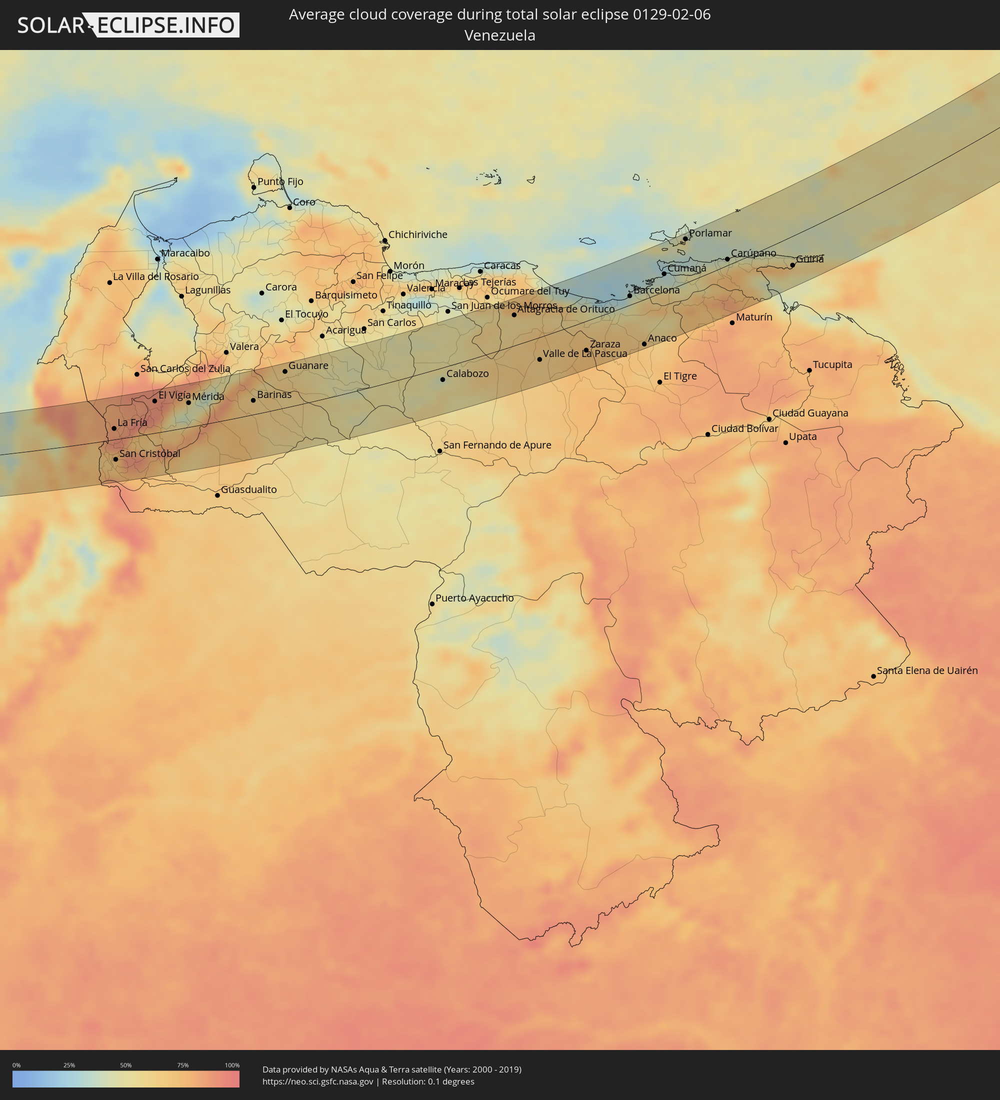 Venezuela
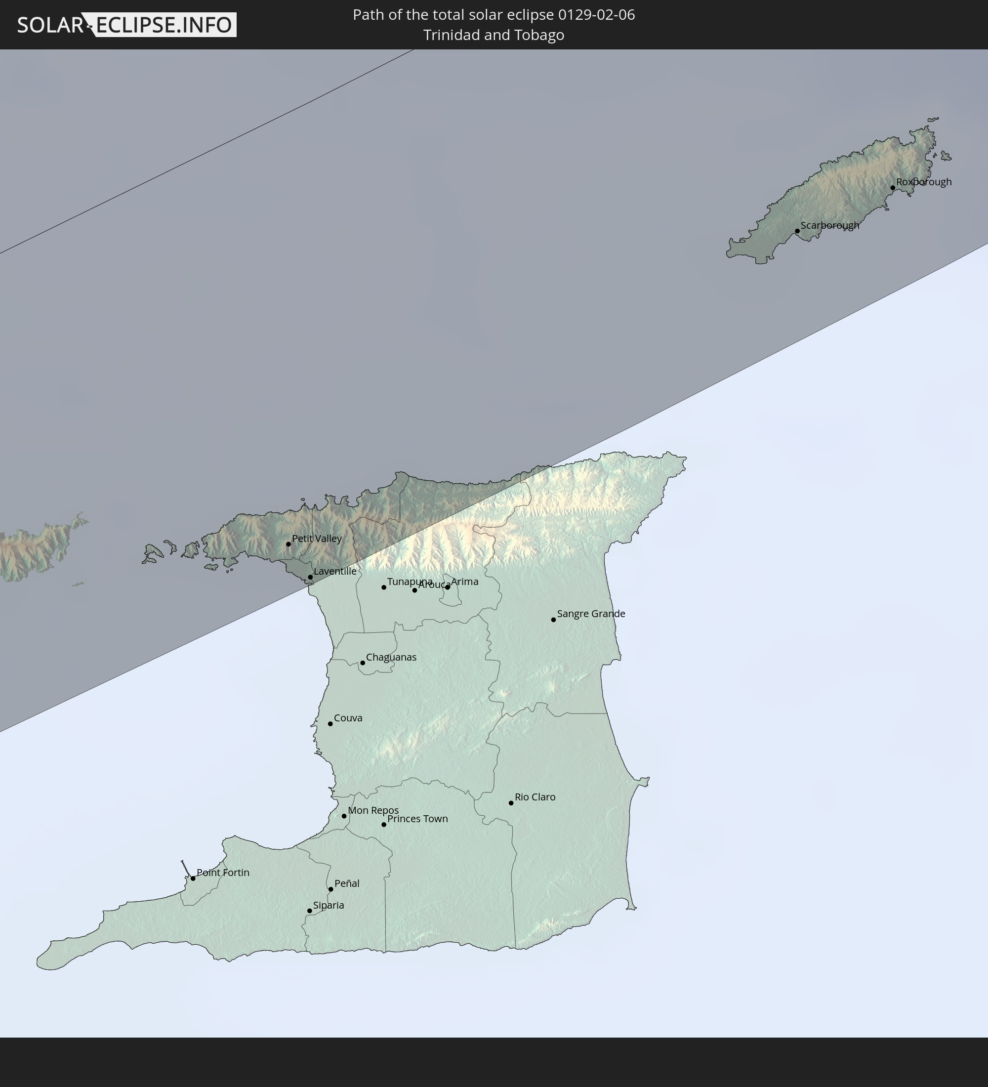
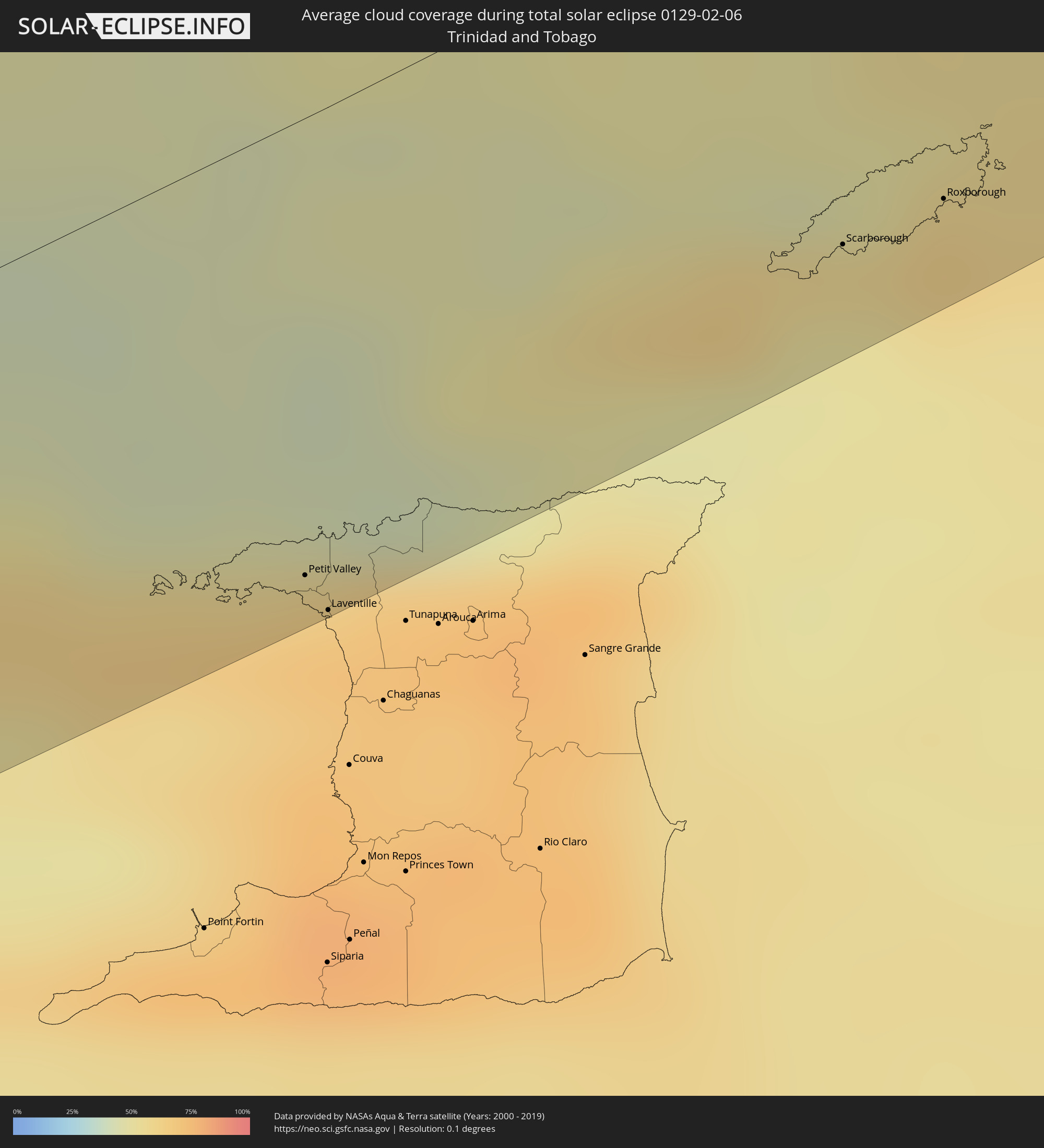 Trinidad and Tobago
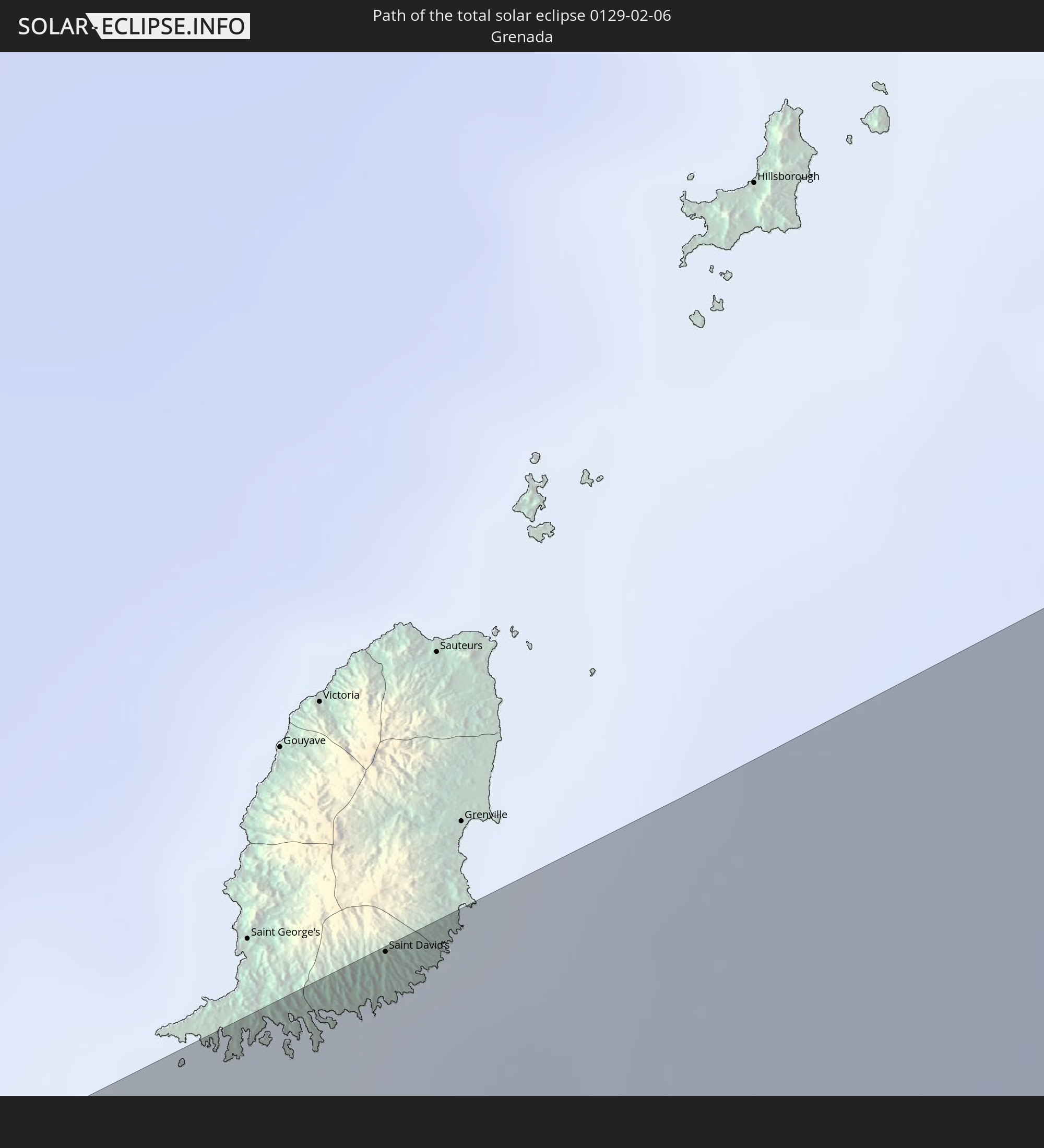
 Grenada
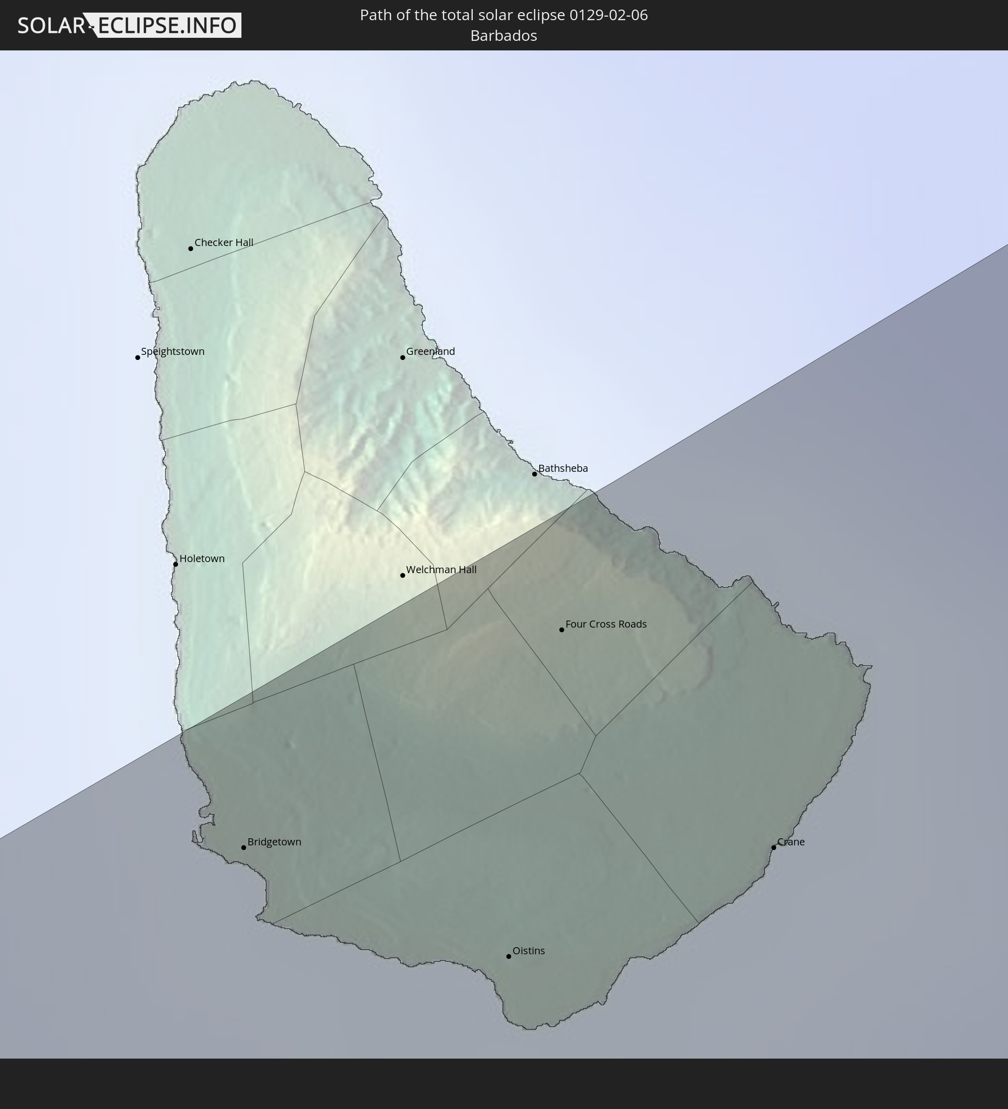
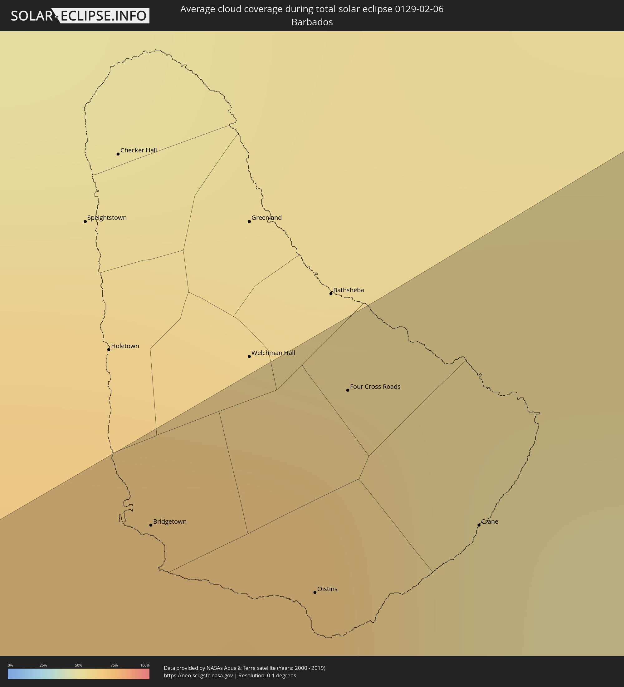 Barbados
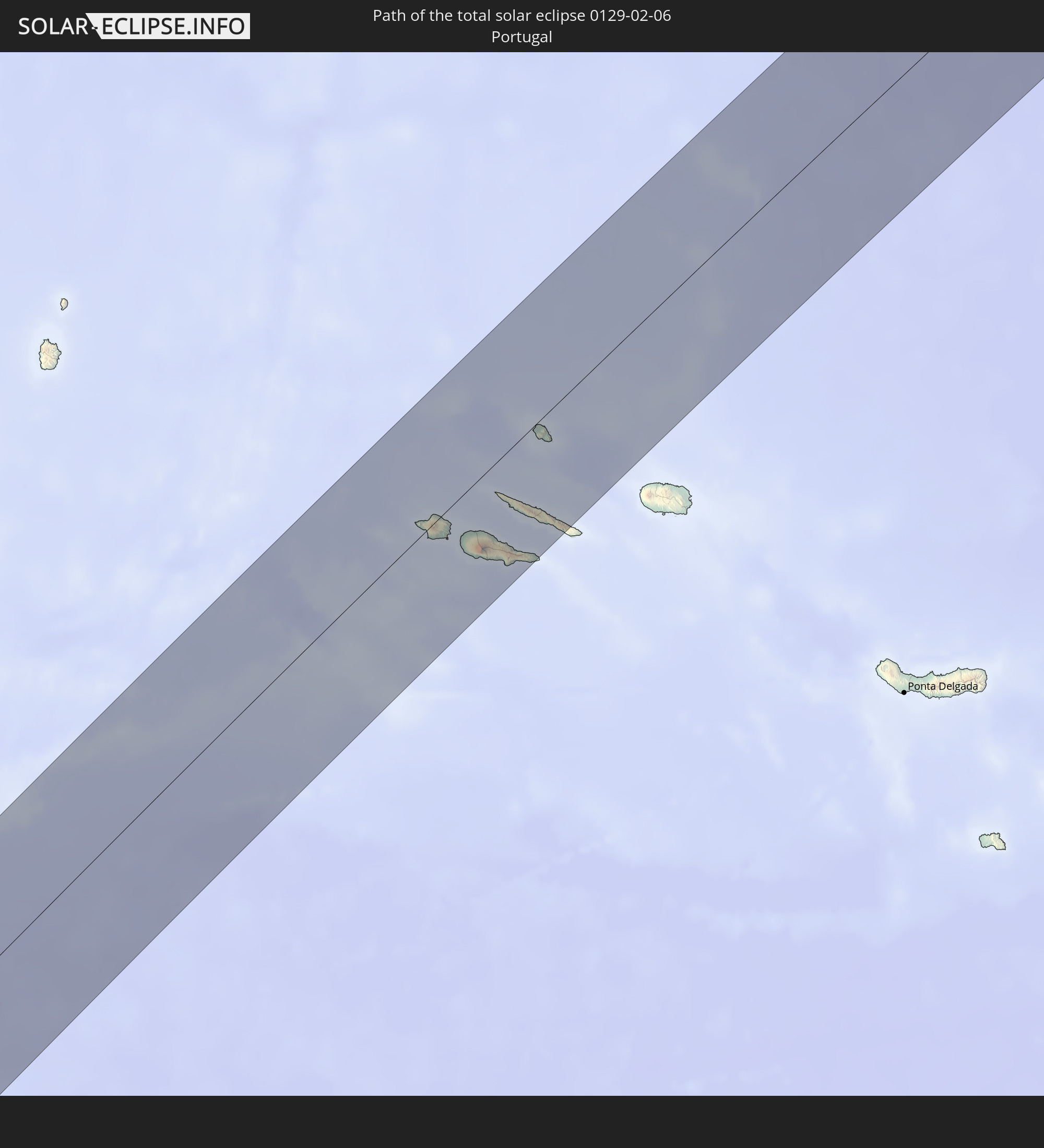
 Portugal
 United Kingdom
Cities inside the path of the eclipse
The following table shows all locations with a population of more than 5,000 inside the eclipse path. Cities which have more than 100,000 inhabitants are marked bold. A click at the locations opens a detailed map.
| City | Type | Eclipse duration | Local time of max. eclipse | Distance to central line | Ø Cloud coverage |
|
Soná, Veraguas
|
total | - | 08:21:05 UTC-05:19 | 46 km | 36% |
|
Santiago de Veraguas, Veraguas
|
total | - | 08:21:38 UTC-05:19 | 57 km | 47% |
|
Chitré, Herrera
|
total | - | 08:22:13 UTC-05:19 | 43 km | 40% |
|
Los Santos, Los Santos
|
total | - | 08:22:12 UTC-05:19 | 40 km | 46% |
|
Las Tablas, Los Santos
|
total | - | 08:22:12 UTC-05:19 | 22 km | 50% |
|
Unión Chocó, Emberá
|
total | - | 08:26:34 UTC-05:19 | 55 km | 74% |
|
Turbo, Antioquia
|
total | - | 08:51:10 UTC-04:56 | 53 km | 77% |
|
Chigorodó, Antioquia
|
total | - | 08:50:42 UTC-04:56 | 5 km | 81% |
|
Carepa, Antioquia
|
total | - | 08:50:52 UTC-04:56 | 15 km | 79% |
|
Apartadó, Antioquia
|
total | - | 08:51:04 UTC-04:56 | 29 km | 88% |
|
Tierralta, Córdoba
|
total | - | 08:52:20 UTC-04:56 | 57 km | 82% |
|
Ituango, Antioquia
|
total | - | 08:51:33 UTC-04:56 | 56 km | 65% |
|
Montelíbano, Córdoba
|
total | - | 08:53:08 UTC-04:56 | 31 km | 82% |
|
Caucasia, Antioquia
|
total | - | 08:53:31 UTC-04:56 | 30 km | 74% |
|
Ayapel, Córdoba
|
total | - | 08:54:01 UTC-04:56 | 65 km | 72% |
|
Pueblo Nuevo, Córdoba
|
total | - | 08:54:14 UTC-04:56 | 56 km | 85% |
|
Zaragoza, Antioquia
|
total | - | 08:53:25 UTC-04:56 | 29 km | 70% |
|
El Bagre, Antioquia
|
total | - | 08:53:40 UTC-04:56 | 17 km | 66% |
|
San Carlos, Antioquia
|
total | - | 08:53:58 UTC-04:56 | 4 km | 68% |
|
Santa Rosa del Sur, Bolívar
|
total | - | 08:55:25 UTC-04:56 | 15 km | 57% |
|
Puerto Wilches, Santander
|
total | - | 08:54:53 UTC-04:56 | 55 km | 47% |
|
Morales, Bolívar
|
total | - | 08:56:09 UTC-04:56 | 47 km | 38% |
|
Aguachica, Cesar
|
total | - | 08:56:38 UTC-04:56 | 48 km | 52% |
|
Sabana de Torres, Santander
|
total | - | 08:55:38 UTC-04:56 | 55 km | 70% |
|
San Alberto, Cesar
|
total | - | 08:56:18 UTC-04:56 | 16 km | 63% |
|
Ocaña, Norte de Santander
|
total | - | 08:57:00 UTC-04:56 | 36 km | 60% |
|
Ábrego, Norte de Santander
|
total | - | 08:57:02 UTC-04:56 | 17 km | 44% |
|
El Zulia, Norte de Santander
|
total | - | 08:57:56 UTC-04:56 | 9 km | 68% |
|
Chinácota, Norte de Santander
|
total | - | 08:57:30 UTC-04:56 | 44 km | 72% |
|
Cúcuta, Norte de Santander
|
total | - | 08:58:03 UTC-04:56 | 14 km | 66% |
|
San Antonio del Táchira, Táchira
|
total | - | 09:26:40 UTC-04:27 | 24 km | 67% |
|
Puerto Santander, Norte de Santander
|
total | - | 08:58:52 UTC-04:56 | 36 km | 80% |
|
Rubio, Táchira
|
total | - | 09:26:40 UTC-04:27 | 38 km | 74% |
|
San Juan de Colón, Táchira
|
total | - | 09:27:17 UTC-04:27 | 3 km | 75% |
|
La Fría, Táchira
|
total | - | 09:27:33 UTC-04:27 | 17 km | 89% |
|
San Cristóbal, Táchira
|
total | - | 09:27:00 UTC-04:27 | 33 km | 73% |
|
Táriba, Táchira
|
total | - | 09:27:04 UTC-04:27 | 27 km | 73% |
|
El Vigía, Mérida
|
total | - | 09:29:12 UTC-04:27 | 50 km | 89% |
|
Ejido, Mérida
|
total | - | 09:29:53 UTC-04:27 | 35 km | 40% |
|
Mérida, Mérida
|
total | - | 09:30:06 UTC-04:27 | 38 km | 44% |
|
Mucumpiz, Mérida
|
total | - | 09:29:54 UTC-04:27 | 19 km | 69% |
|
Barinitas, Barinas
|
total | - | 09:31:46 UTC-04:27 | 41 km | 65% |
|
Alto Barinas, Barinas
|
total | - | 09:31:53 UTC-04:27 | 19 km | 62% |
|
Barinas, Barinas
|
total | - | 09:31:57 UTC-04:27 | 21 km | 62% |
|
Guanare, Portuguesa
|
total | - | 09:33:28 UTC-04:27 | 56 km | 64% |
|
Calabozo, Guárico
|
total | - | 09:37:57 UTC-04:27 | 19 km | 55% |
|
Altagracia de Orituco, Guárico
|
total | - | 09:41:34 UTC-04:27 | 46 km | 58% |
|
Valle de La Pascua, Guárico
|
total | - | 09:41:23 UTC-04:27 | 35 km | 62% |
|
Zaraza, Guárico
|
total | - | 09:43:03 UTC-04:27 | 45 km | 72% |
|
Barcelona, Anzoátegui
|
total | - | 09:45:39 UTC-04:27 | 13 km | 49% |
|
Anaco, Anzoátegui
|
total | - | 09:45:02 UTC-04:27 | 68 km | 70% |
|
Cumaná, Sucre
|
total | - | 09:47:15 UTC-04:27 | 26 km | 37% |
|
Porlamar, Nueva Esparta
|
total | - | 09:48:45 UTC-04:27 | 65 km | 46% |
|
La Asunción, Nueva Esparta
|
total | - | 09:48:53 UTC-04:27 | 72 km | 46% |
|
Carúpano, Sucre
|
total | - | 09:49:40 UTC-04:27 | 8 km | 61% |
|
Güiria, Sucre
|
total | - | 09:51:40 UTC-04:27 | 43 km | 51% |
|
Saint David’s, Saint David
|
total | - | 10:17:06 UTC-04:06 | 74 km | 51% |
|
Petit Valley, Diego Martin
|
total | - | 10:15:12 UTC-04:06 | 67 km | 69% |
|
Port of Spain, City of Port of Spain
|
total | - | 10:15:11 UTC-04:06 | 71 km | 69% |
|
Laventille, San Juan/Laventille
|
total | - | 10:15:12 UTC-04:06 | 74 km | 67% |
|
Scarborough, Tobago
|
total | - | 10:17:50 UTC-04:06 | 58 km | 51% |
|
Roxborough, Eastern Tobago
|
total | - | 10:18:17 UTC-04:06 | 59 km | 61% |
|
Bridgetown, Saint Michael
|
total | - | 10:31:11 UTC-03:58 | 70 km | 61% |
|
Oistins, Christ Church
|
total | - | 10:31:20 UTC-03:58 | 63 km | 58% |
|
Four Cross Roads, Saint John
|
total | - | 10:31:32 UTC-03:58 | 71 km | 65% |
|
Crane, Saint Philip
|
total | - | 10:31:35 UTC-03:58 | 61 km | 58% |
|
Ribeira Grande, Azores
|
total | - | 15:59:07 UTC+00:00 | 7 km | 81% |
|
Horta, Azores
|
total | - | 14:04:40 UTC-01:54 | 10 km | 81% |
|
Madalena, Azores
|
total | - | 14:04:48 UTC-01:54 | 16 km | 83% |
|
Lagoa, Azores
|
total | - | 14:05:37 UTC-01:54 | 8 km | 83% |
|
Wrexham, Wales
|
total | - | 16:16:39 UTC+00:00 | 9 km | 83% |
|
Liverpool, England
|
total | - | 16:16:24 UTC+00:00 | 43 km | 80% |
|
Chester, England
|
total | - | 16:16:35 UTC+00:00 | 19 km | 82% |
|
Shrewsbury, England
|
total | - | 16:16:59 UTC+00:00 | 31 km | 85% |
|
St Helens, England
|
total | - | 16:16:29 UTC+00:00 | 37 km | 85% |
|
Northwich, England
|
total | - | 16:16:42 UTC+00:00 | 12 km | 86% |
|
Crewe, England
|
total | - | 16:16:51 UTC+00:00 | 6 km | 86% |
|
Bolton, England
|
total | - | 16:16:31 UTC+00:00 | 39 km | 86% |
|
Manchester, England
|
total | - | 16:16:40 UTC+00:00 | 22 km | 84% |
|
Stoke-on-Trent, England
|
total | - | 16:17:01 UTC+00:00 | 24 km | 86% |
|
Rochdale, England
|
total | - | 16:16:36 UTC+00:00 | 32 km | 86% |
|
Macclesfield, England
|
total | - | 16:16:52 UTC+00:00 | 2 km | 89% |
|
High Peak, England
|
total | - | 16:16:54 UTC+00:00 | 2 km | 87% |
|
Huddersfield, England
|
total | - | 16:16:44 UTC+00:00 | 22 km | 84% |
|
Leeds, England
|
total | - | 16:16:43 UTC+00:00 | 28 km | 81% |
|
Barnsley, England
|
total | - | 16:16:55 UTC+00:00 | 2 km | 79% |
|
Sheffield, England
|
total | - | 16:17:03 UTC+00:00 | 14 km | 83% |
|
Chesterfield, England
|
total | - | 16:17:10 UTC+00:00 | 28 km | 80% |
|
Doncaster, England
|
total | - | 16:17:05 UTC+00:00 | 13 km | 79% |
|
Worksop, England
|
total | - | 16:17:14 UTC+00:00 | 34 km | 79% |
|
York, England
|
total | - | 16:16:47 UTC+00:00 | 26 km | 82% |
|
Scunthorpe, England
|
total | - | 16:17:14 UTC+00:00 | 24 km | 80% |
|
Scarborough, England
|
total | - | 16:16:48 UTC+00:00 | 33 km | 81% |
|
Hull, England
|
total | - | 16:17:14 UTC+00:00 | 20 km | 81% |
|
Bridlington, England
|
total | - | 16:17:02 UTC+00:00 | 8 km | 77% |