Annular solar eclipse of 07/24/0138
| Day of week: | Thursday |
| Maximum duration of eclipse: | 07m29s |
| Maximum width of eclipse path: | 422 km |
| Saros cycle: | 67 |
| Coverage: | 93.7% |
| Magnitude: | 0.937 |
| Gamma: | -0.832 |
Wo kann man die Sonnenfinsternis vom 07/24/0138 sehen?

Die Sonnenfinsternis am 07/24/0138 kann man in 17 Ländern als partielle Sonnenfinsternis beobachten.
Der Finsternispfad verläuft durch 3 Länder. Nur in diesen Ländern ist sie als annular Sonnenfinsternis zu sehen.
In den folgenden Ländern ist die Sonnenfinsternis annular zu sehen
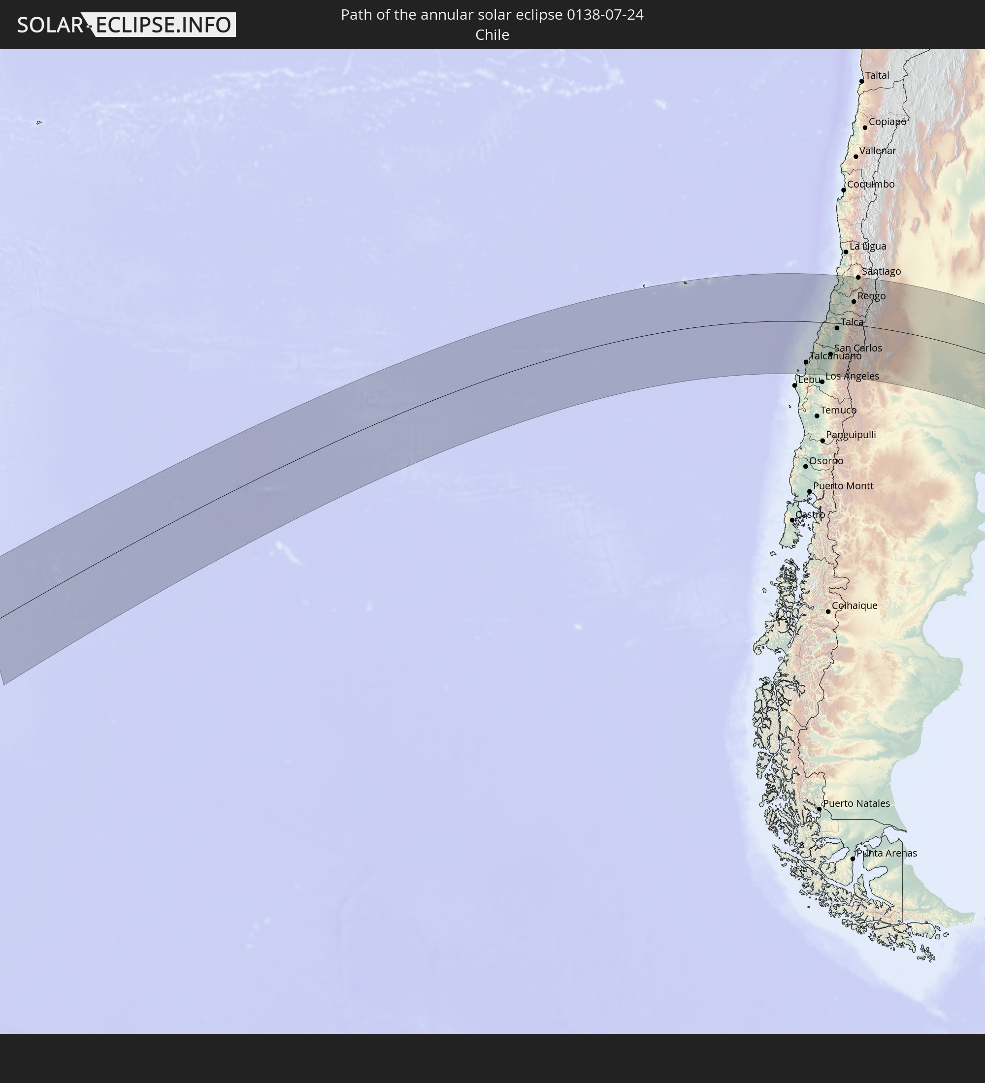 Chile
Chile
 Argentina
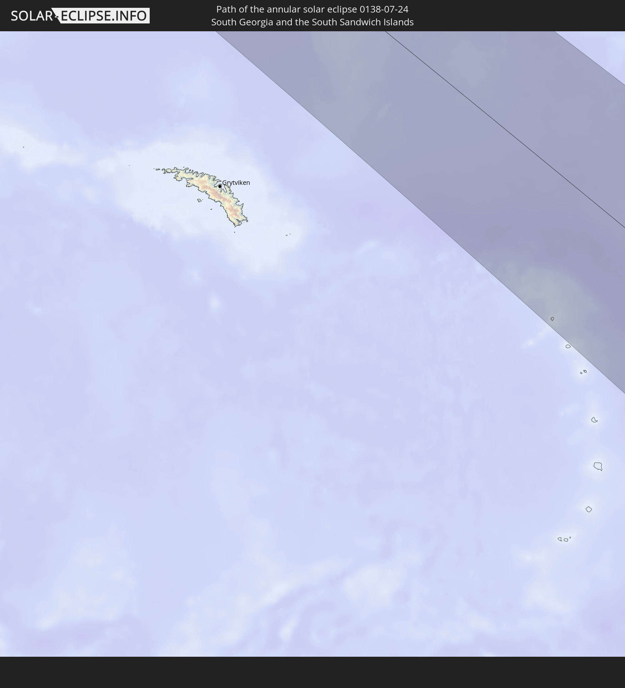 South Georgia and the South Sandwich Islands
In den folgenden Ländern ist die Sonnenfinsternis partiell zu sehen


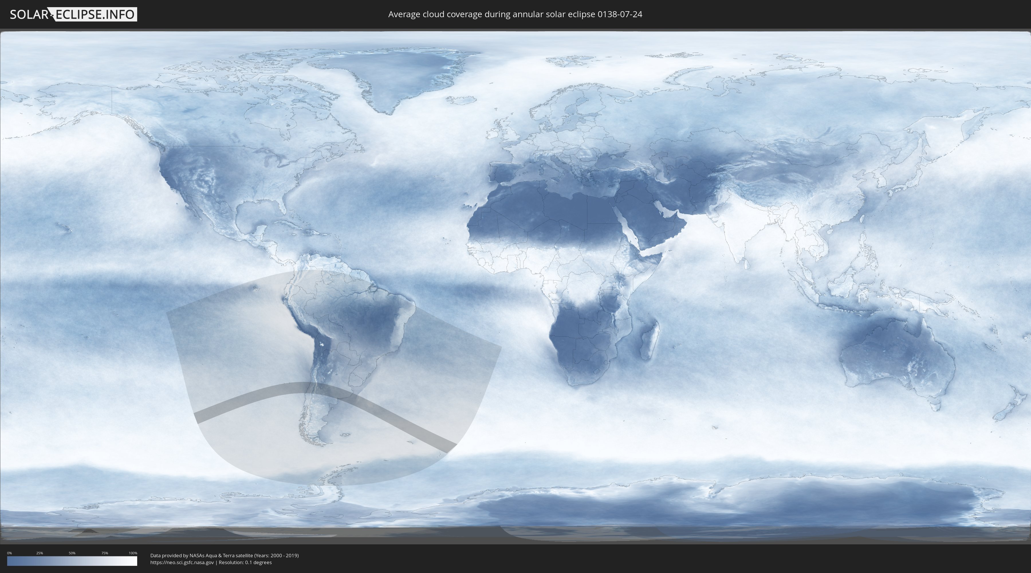
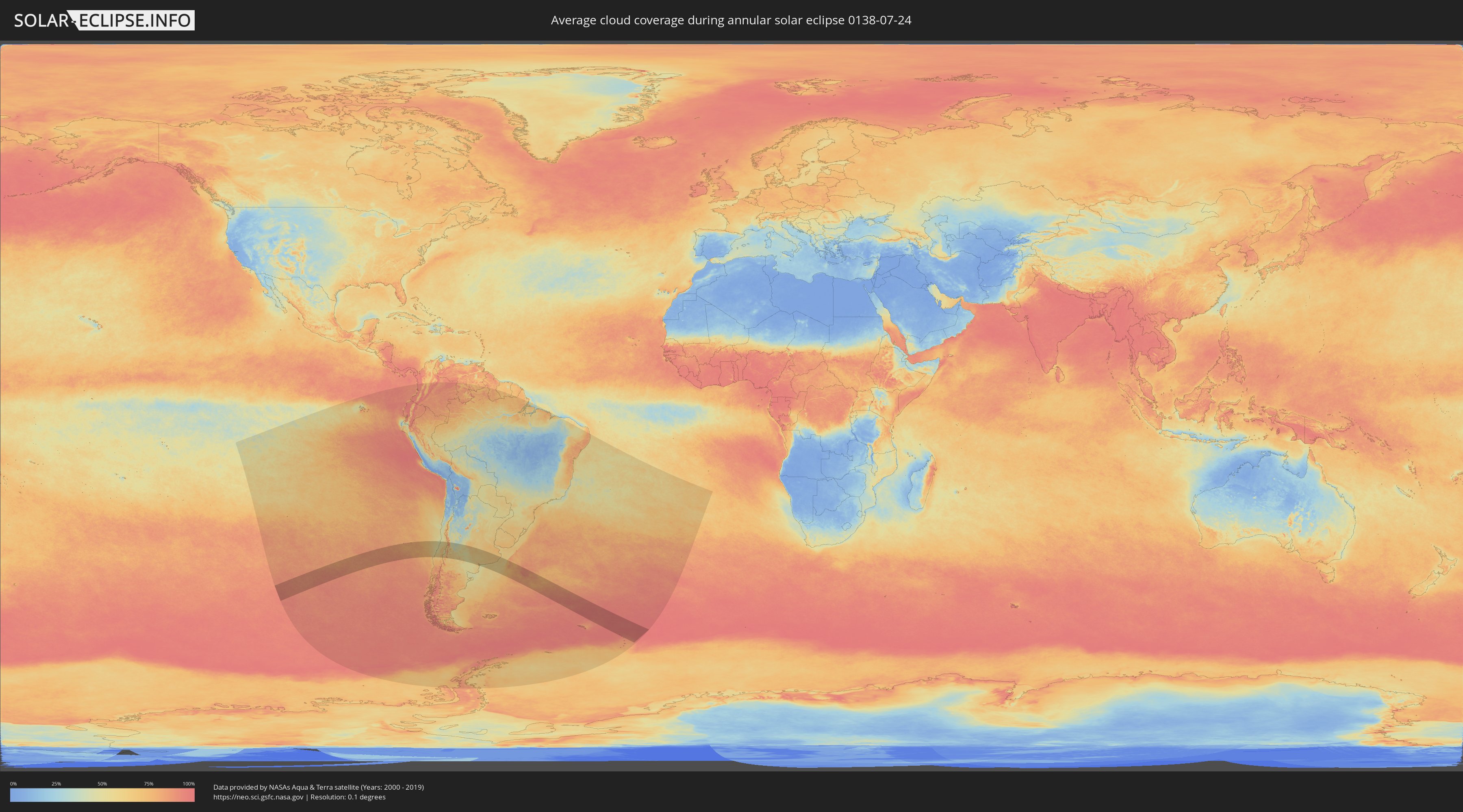
How will be the weather during the annular solar eclipse on 07/24/0138?
Where is the best place to see the annular solar eclipse of 07/24/0138?
The following maps show the average cloud coverage for the day of the annular solar eclipse.
With the help of these maps, it is possible to find the place along the eclipse path, which has the best
chance of a cloudless sky.
Nevertheless, you should consider local circumstances and inform about the weather of your chosen
observation site.
The data is provided by NASAs satellites
AQUA and TERRA.
The cloud maps are averaged over a period of 19 years (2000 - 2019).
Detailed country maps
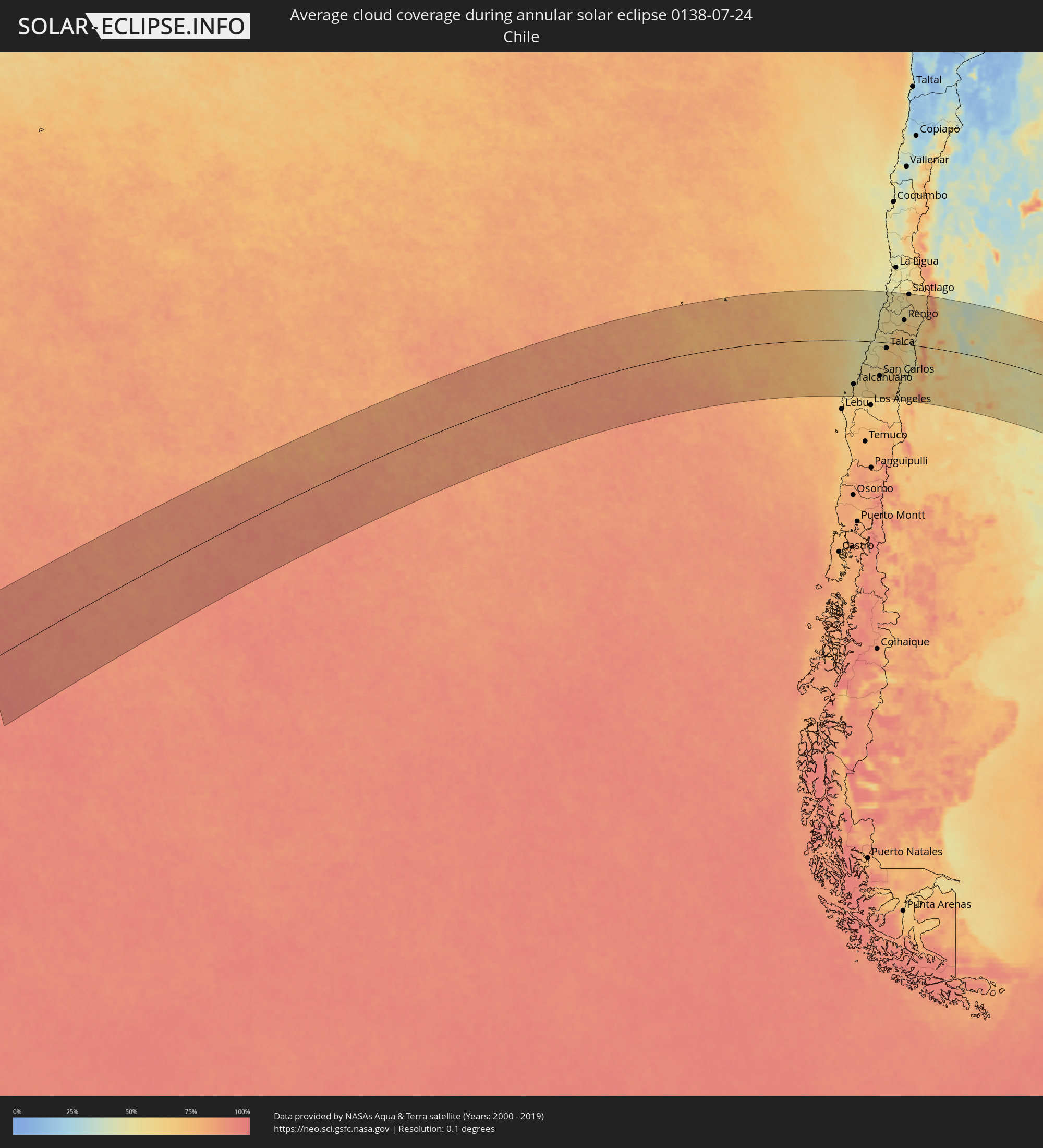 Chile
Chile
 Argentina
 South Georgia and the South Sandwich Islands
Cities inside the path of the eclipse
The following table shows all locations with a population of more than 5,000 inside the eclipse path. Cities which have more than 100,000 inhabitants are marked bold. A click at the locations opens a detailed map.
| City | Type | Eclipse duration | Local time of max. eclipse | Distance to central line | Ø Cloud coverage |
 Lota, Biobío
|
annular | - | 11:09:24 UTC-04:42 | 215 km | 59% |
|
Coronel, Biobío
|
annular | - | 11:09:24 UTC-04:42 | 209 km | 60% |
|
Talcahuano, Biobío
|
annular | - | 11:09:13 UTC-04:42 | 174 km | 57% |
|
Concepción, Biobío
|
annular | - | 11:09:29 UTC-04:42 | 186 km | 60% |
|
Chiguayante, Biobío
|
annular | - | 11:09:37 UTC-04:42 | 196 km | 62% |
|
Penco, Biobío
|
annular | - | 11:09:33 UTC-04:42 | 176 km | 57% |
|
Tomé, Biobío
|
annular | - | 11:09:34 UTC-04:42 | 162 km | 55% |
|
Yumbel, Biobío
|
annular | - | 11:11:01 UTC-04:42 | 214 km | 62% |
|
Constitución, Maule
|
annular | - | 11:10:04 UTC-04:42 | 17 km | 49% |
|
Cabrero, Biobío
|
annular | - | 11:11:23 UTC-04:42 | 206 km | 63% |
|
Cauquenes, Maule
|
annular | - | 11:10:48 UTC-04:42 | 87 km | 55% |
|
Bulnes, Biobío
|
annular | - | 11:11:27 UTC-04:42 | 173 km | 63% |
|
Chillán, Biobío
|
annular | - | 11:11:53 UTC-04:42 | 156 km | 65% |
|
San Carlos, Biobío
|
annular | - | 11:12:09 UTC-04:42 | 135 km | 62% |
|
Coihueco, Biobío
|
annular | - | 11:12:39 UTC-04:42 | 157 km | 58% |
|
Parral, Maule
|
annular | - | 11:12:19 UTC-04:42 | 103 km | 62% |
|
San Javier, Maule
|
annular | - | 11:12:10 UTC-04:42 | 41 km | 62% |
|
Longaví, Maule
|
annular | - | 11:12:34 UTC-04:42 | 82 km | 64% |
|
Talca, Maule
|
annular | - | 11:12:15 UTC-04:42 | 22 km | 66% |
|
Cartagena, Valparaíso
|
annular | - | 11:11:00 UTC-04:42 | 186 km | 48% |
|
San Antonio, Valparaíso
|
annular | - | 11:11:02 UTC-04:42 | 182 km | 48% |
|
Linares, Maule
|
annular | - | 11:12:44 UTC-04:42 | 68 km | 67% |
|
San Clemente, Maule
|
annular | - | 11:12:48 UTC-04:42 | 33 km | 66% |
|
Santa Cruz, O'Higgins
|
annular | - | 11:12:30 UTC-04:42 | 68 km | 55% |
|
Rauco, Maule
|
annular | - | 11:12:50 UTC-04:42 | 36 km | 67% |
|
Molina, Maule
|
annular | - | 11:13:05 UTC-04:42 | 16 km | 68% |
|
Curicó, Maule
|
annular | - | 11:13:06 UTC-04:42 | 31 km | 70% |
|
Melipilla, Santiago Metropolitan
|
annular | - | 11:12:14 UTC-04:42 | 174 km | 52% |
|
Teno, Maule
|
annular | - | 11:13:14 UTC-04:42 | 44 km | 70% |
|
San Vicente, O'Higgins
|
annular | - | 11:13:09 UTC-04:42 | 93 km | 58% |
|
San Vicente de Tagua Tagua, O'Higgins
|
annular | - | 11:13:10 UTC-04:42 | 92 km | 58% |
|
Chimbarongo, O'Higgins
|
annular | - | 11:13:28 UTC-04:42 | 62 km | 67% |
|
El Monte, Santiago Metropolitan
|
annular | - | 11:12:53 UTC-04:42 | 177 km | 52% |
|
Talagante, Santiago Metropolitan
|
annular | - | 11:13:03 UTC-04:42 | 179 km | 53% |
|
Peñaflor, Santiago Metropolitan
|
annular | - | 11:13:09 UTC-04:42 | 186 km | 51% |
|
Rengo, O'Higgins
|
annular | - | 11:13:46 UTC-04:42 | 98 km | 55% |
|
Rancagua, O'Higgins
|
annular | - | 11:13:56 UTC-04:42 | 125 km | 55% |
|
Buin, Santiago Metropolitan
|
annular | - | 11:13:38 UTC-04:42 | 174 km | 52% |
|
Paine, Santiago Metropolitan
|
annular | - | 11:13:41 UTC-04:42 | 165 km | 51% |
|
Graneros, O'Higgins
|
annular | - | 11:13:55 UTC-04:42 | 136 km | 55% |
|
Lo Prado, Santiago Metropolitan
|
annular | - | 11:13:28 UTC-04:42 | 206 km | 65% |
|
San Bernardo, Santiago Metropolitan
|
annular | - | 11:13:39 UTC-04:42 | 189 km | 55% |
|
Machalí, O'Higgins
|
annular | - | 11:14:13 UTC-04:42 | 125 km | 54% |
|
Santiago, Santiago Metropolitan
|
annular | - | 11:13:42 UTC-04:42 | 205 km | 63% |
|
La Pintana, Santiago Metropolitan
|
annular | - | 11:13:50 UTC-04:42 | 191 km | 57% |
|
Villa Presidente Frei, Ñuñoa, Santiago, Chile, Santiago Metropolitan
|
annular | - | 11:13:54 UTC-04:42 | 205 km | 63% |
|
Puente Alto, Santiago Metropolitan
|
annular | - | 11:14:02 UTC-04:42 | 189 km | 57% |
 San Rafael, Mendoza Province
|
annular | - | 11:47:10 UTC-04:16 | 109 km | 47% |
|
Victorica, La Pampa Province
|
annular | - | 11:56:19 UTC-04:16 | 1 km | 50% |
|
General Acha, La Pampa Province
|
annular | - | 11:59:08 UTC-04:16 | 101 km | 51% |
|
Villa Huidobro, Cordoba Province
|
annular | - | 11:58:07 UTC-04:16 | 168 km | 67% |
|
Huinca Renancó, Cordoba Province
|
annular | - | 11:58:44 UTC-04:16 | 173 km | 67% |
|
Eduardo Castex, La Pampa Province
|
annular | - | 11:59:24 UTC-04:16 | 62 km | 65% |
|
Santa Rosa, La Pampa Province
|
annular | - | 11:59:43 UTC-04:16 | 12 km | 58% |
|
Realicó, La Pampa Province
|
annular | - | 11:59:11 UTC-04:16 | 156 km | 64% |
|
General Pico, La Pampa Province
|
annular | - | 12:00:49 UTC-04:16 | 104 km | 67% |
|
Intendente Alvear, La Pampa Province
|
annular | - | 12:01:08 UTC-04:16 | 154 km | 60% |
|
Guatraché, La Pampa Province
|
annular | - | 12:02:11 UTC-04:16 | 99 km | 61% |
|
Bahía Blanca, Buenos Aires
|
annular | - | 12:05:52 UTC-04:16 | 165 km | 67% |
|
Punta Alta, Buenos Aires
|
annular | - | 12:06:26 UTC-04:16 | 174 km | 59% |
|
Coronel Suárez, Buenos Aires
|
annular | - | 12:06:27 UTC-04:16 | 24 km | 59% |
|
Coronel Dorrego, Buenos Aires
|
annular | - | 12:08:28 UTC-04:16 | 130 km | 61% |
|
Olavarría, Buenos Aires
|
annular | - | 12:10:40 UTC-04:16 | 90 km | 66% |
|
Tres Arroyos, Buenos Aires
|
annular | - | 12:11:03 UTC-04:16 | 58 km | 65% |
|
Azul, Buenos Aires
|
annular | - | 12:11:53 UTC-04:16 | 119 km | 67% |
|
Tandil, Buenos Aires
|
annular | - | 12:13:54 UTC-04:16 | 91 km | 65% |
|
Necochea, Buenos Aires
|
annular | - | 12:15:03 UTC-04:16 | 16 km | 59% |
|
Mar del Plata, Buenos Aires
|
annular | - | 12:18:01 UTC-04:16 | 86 km | 66% |
|
Villa Gesell, Buenos Aires
|
annular | - | 12:19:28 UTC-04:16 | 183 km | 61% |