Total solar eclipse of 06/12/0169
| Day of week: | Monday |
| Maximum duration of eclipse: | 05m25s |
| Maximum width of eclipse path: | 328 km |
| Saros cycle: | 88 |
| Coverage: | 100% |
| Magnitude: | 1.061 |
| Gamma: | -0.7904 |
Wo kann man die Sonnenfinsternis vom 06/12/0169 sehen?
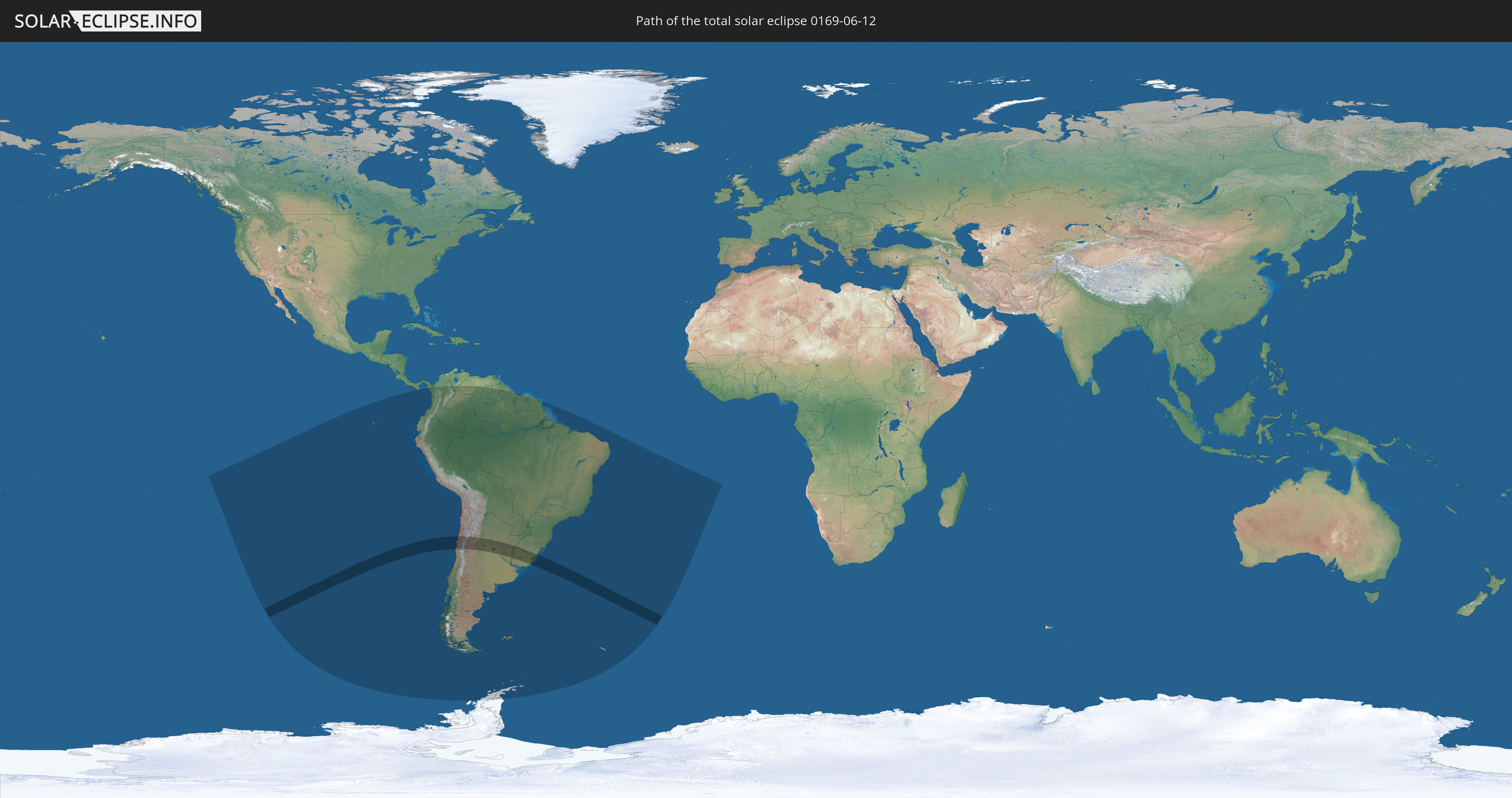
Die Sonnenfinsternis am 06/12/0169 kann man in 19 Ländern als partielle Sonnenfinsternis beobachten.
Der Finsternispfad verläuft durch 4 Länder. Nur in diesen Ländern ist sie als total Sonnenfinsternis zu sehen.
In den folgenden Ländern ist die Sonnenfinsternis total zu sehen
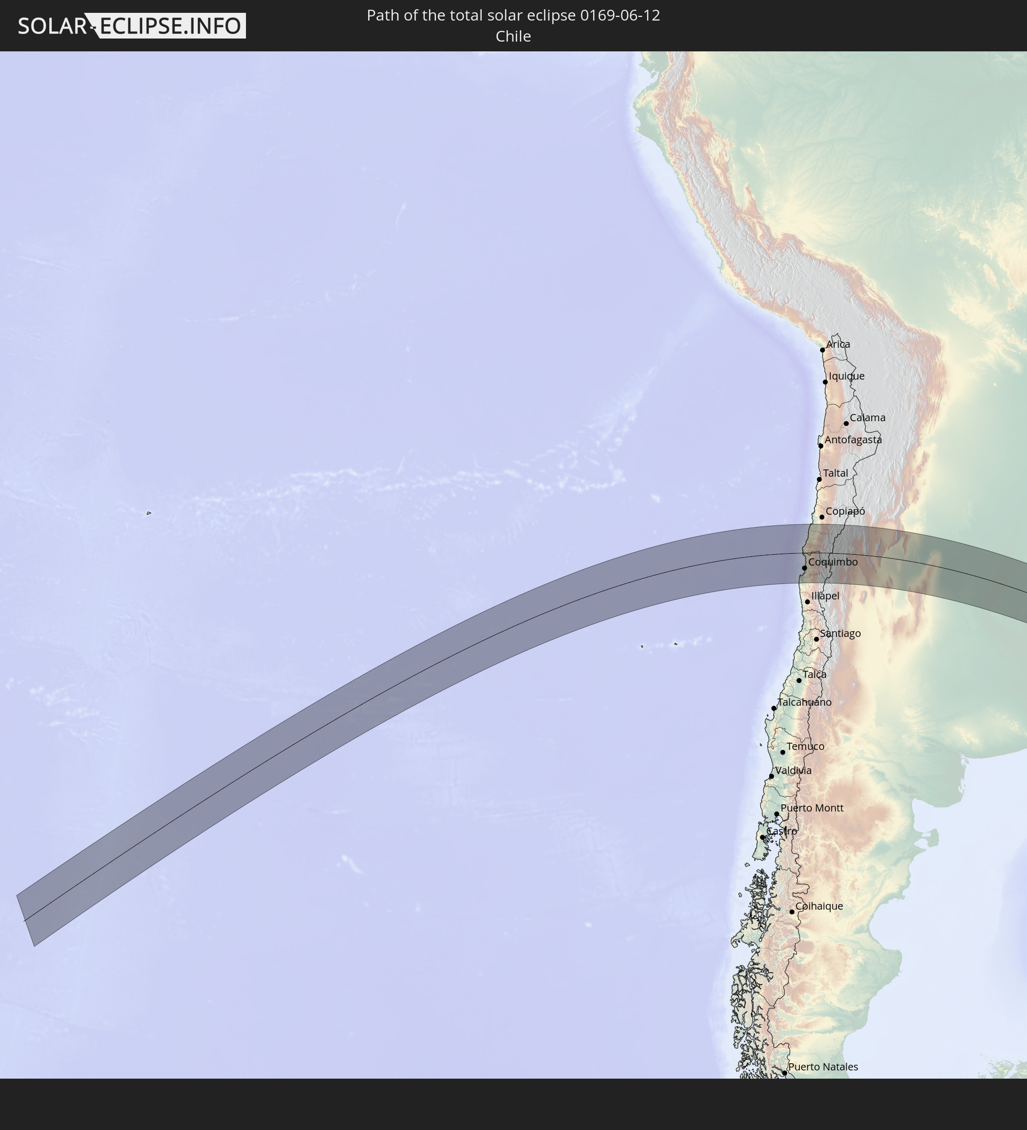 Chile
Chile
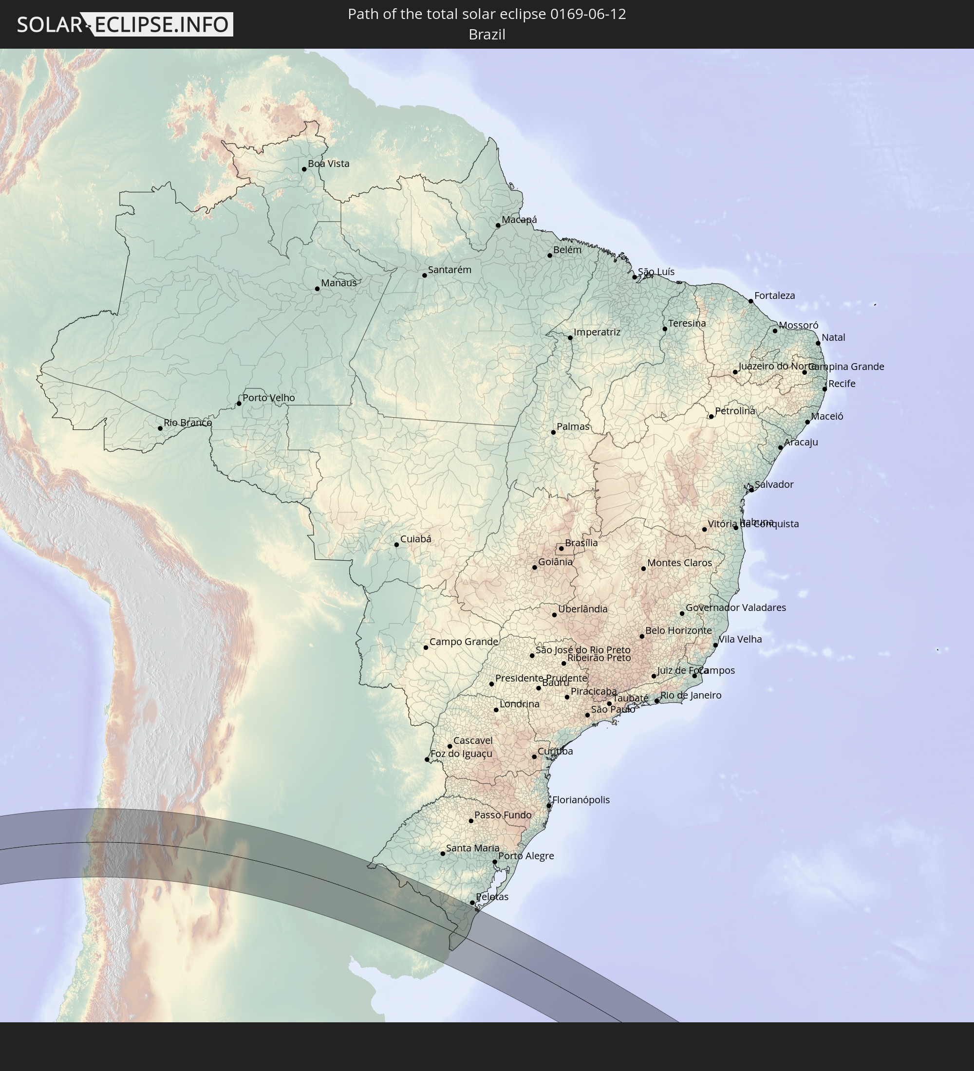 Brazil
 Argentina
 Uruguay
In den folgenden Ländern ist die Sonnenfinsternis partiell zu sehen


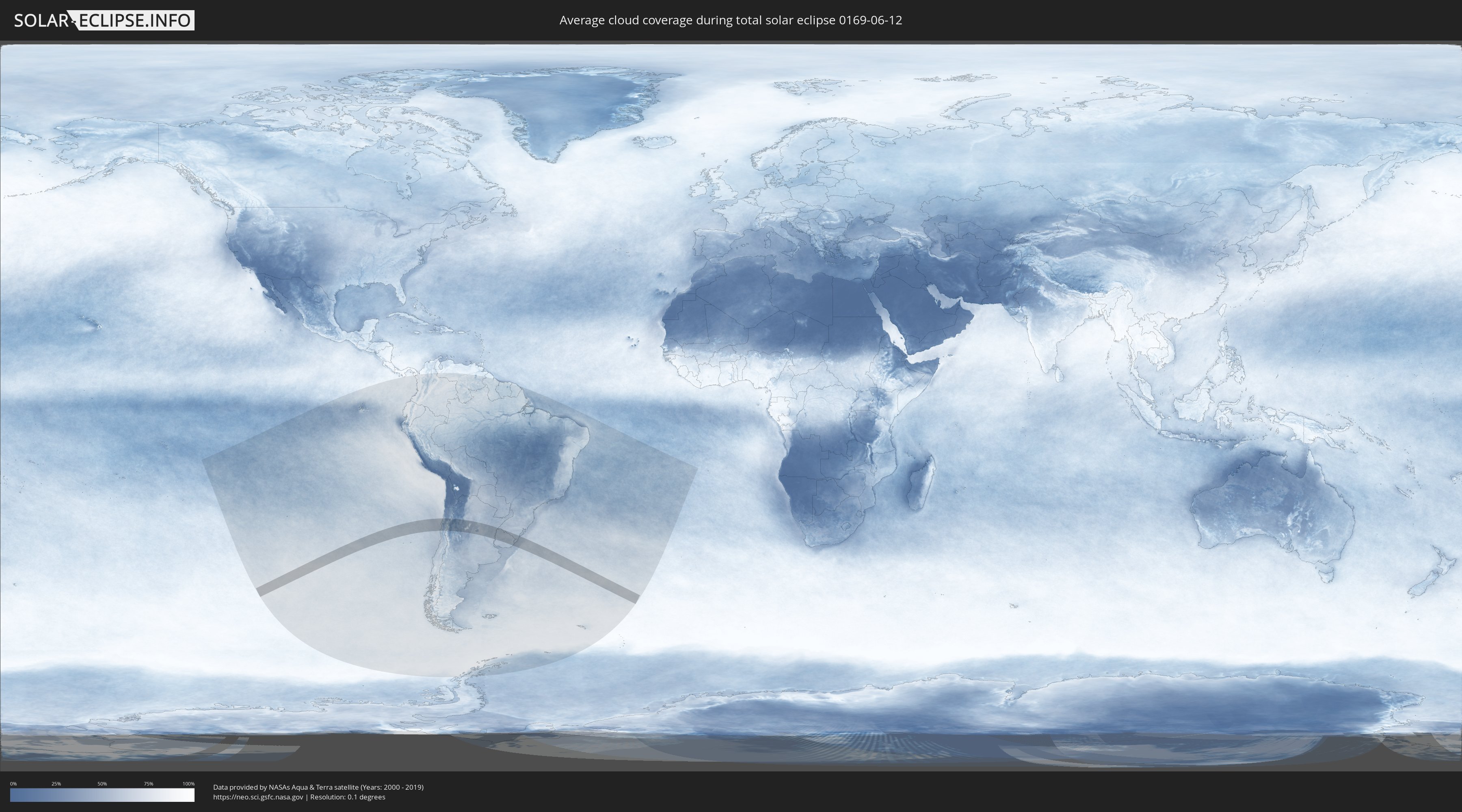
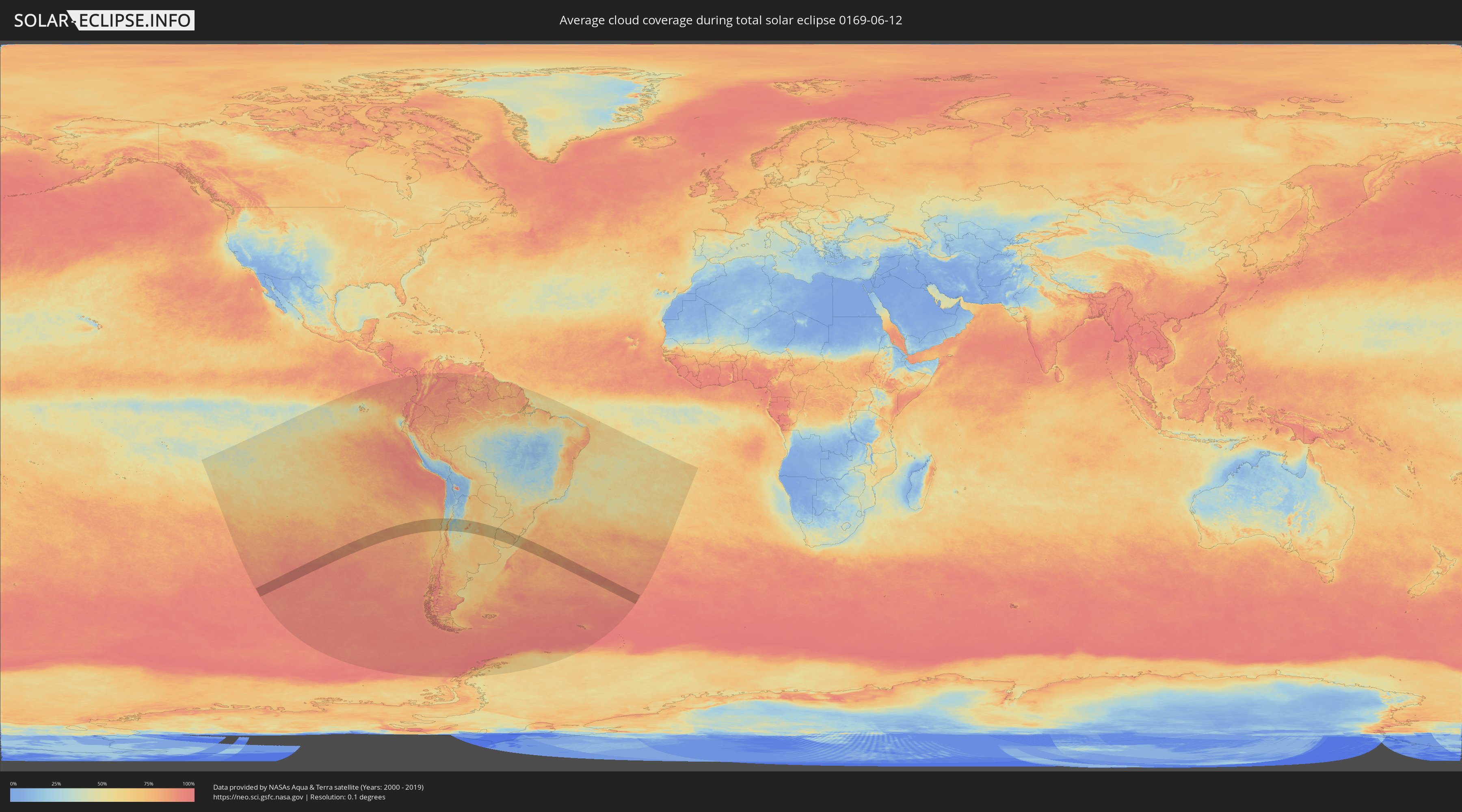
How will be the weather during the total solar eclipse on 06/12/0169?
Where is the best place to see the total solar eclipse of 06/12/0169?
The following maps show the average cloud coverage for the day of the total solar eclipse.
With the help of these maps, it is possible to find the place along the eclipse path, which has the best
chance of a cloudless sky.
Nevertheless, you should consider local circumstances and inform about the weather of your chosen
observation site.
The data is provided by NASAs satellites
AQUA and TERRA.
The cloud maps are averaged over a period of 19 years (2000 - 2019).
Detailed country maps
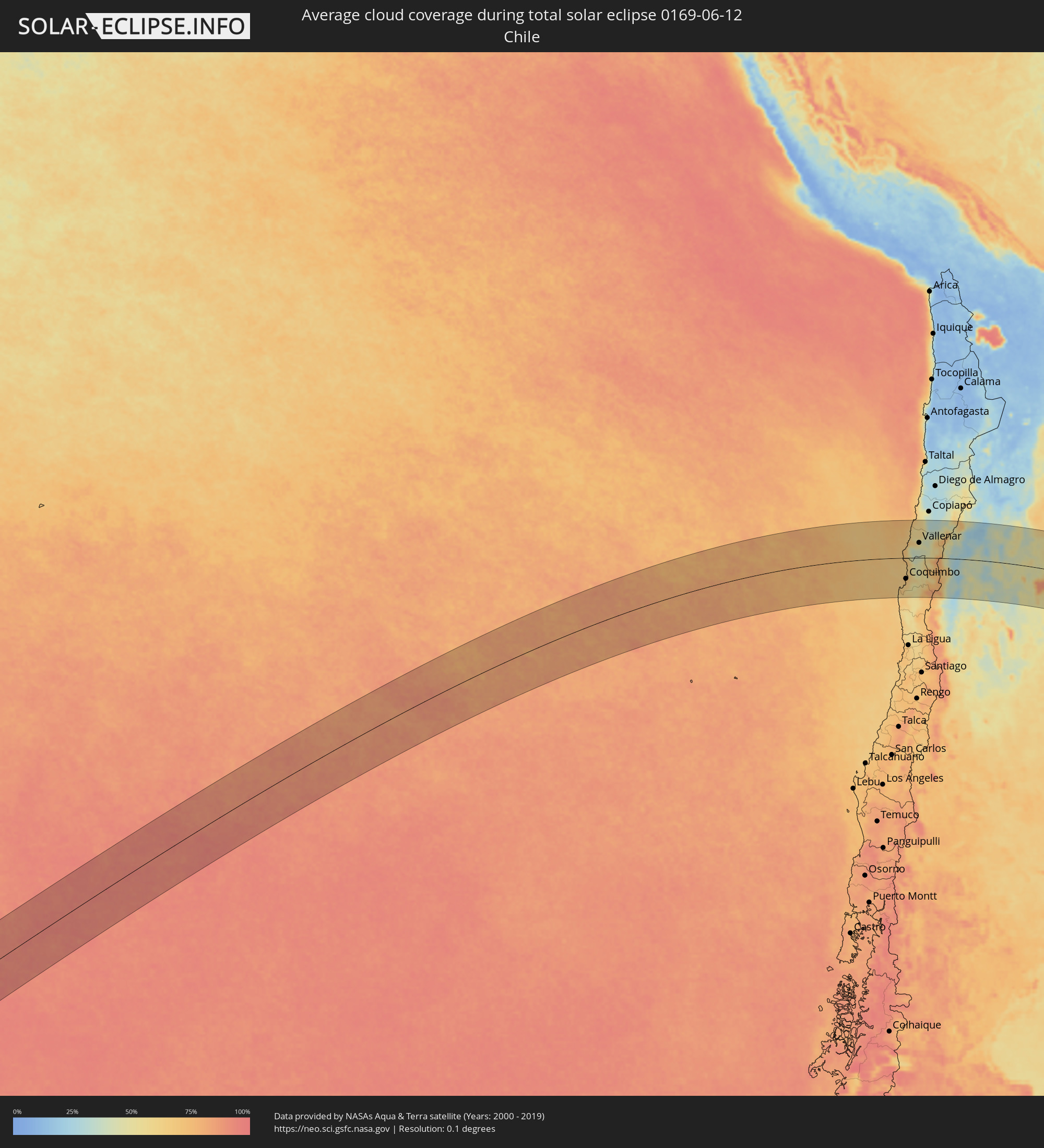 Chile
Chile
 Brazil
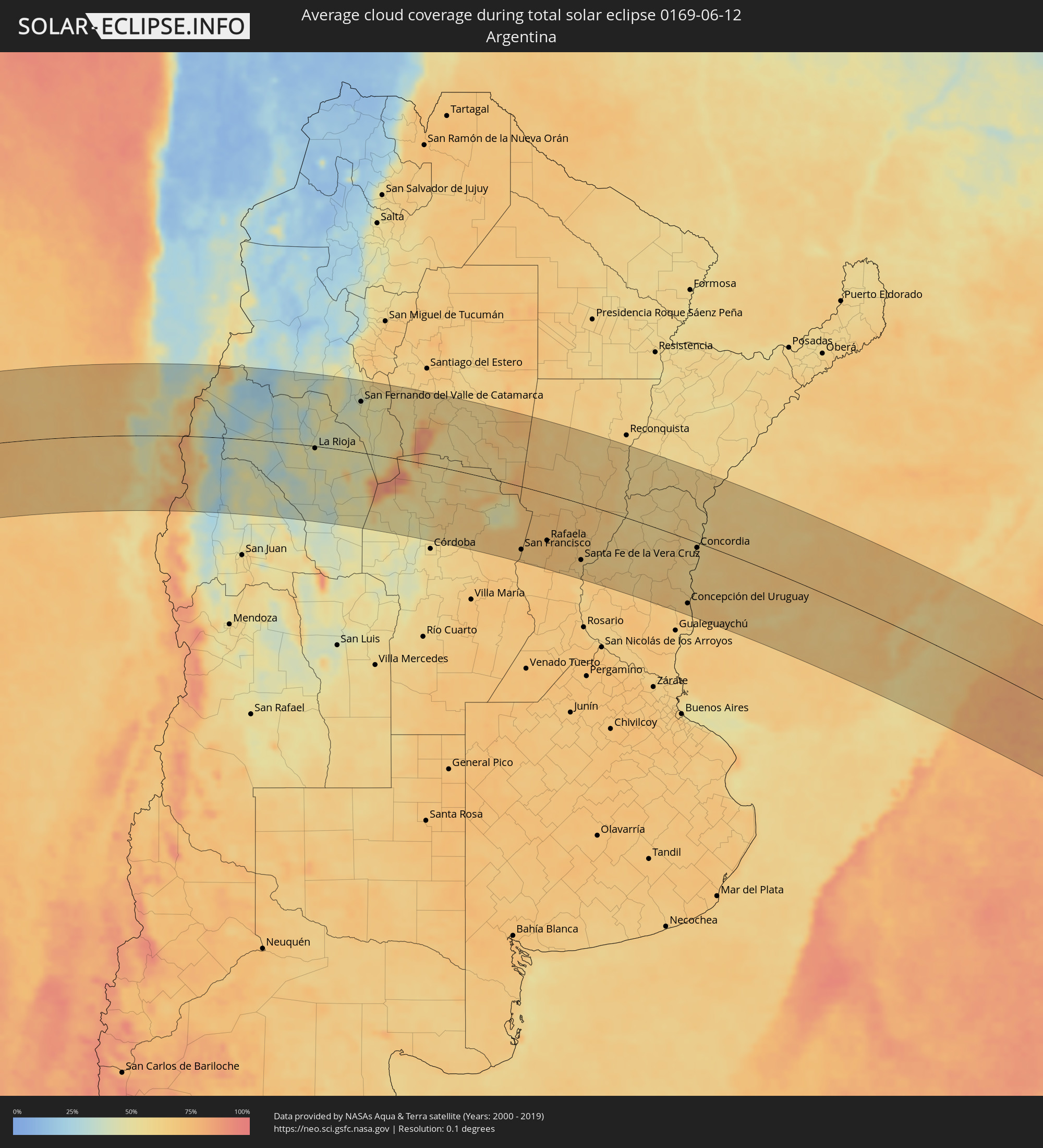 Argentina
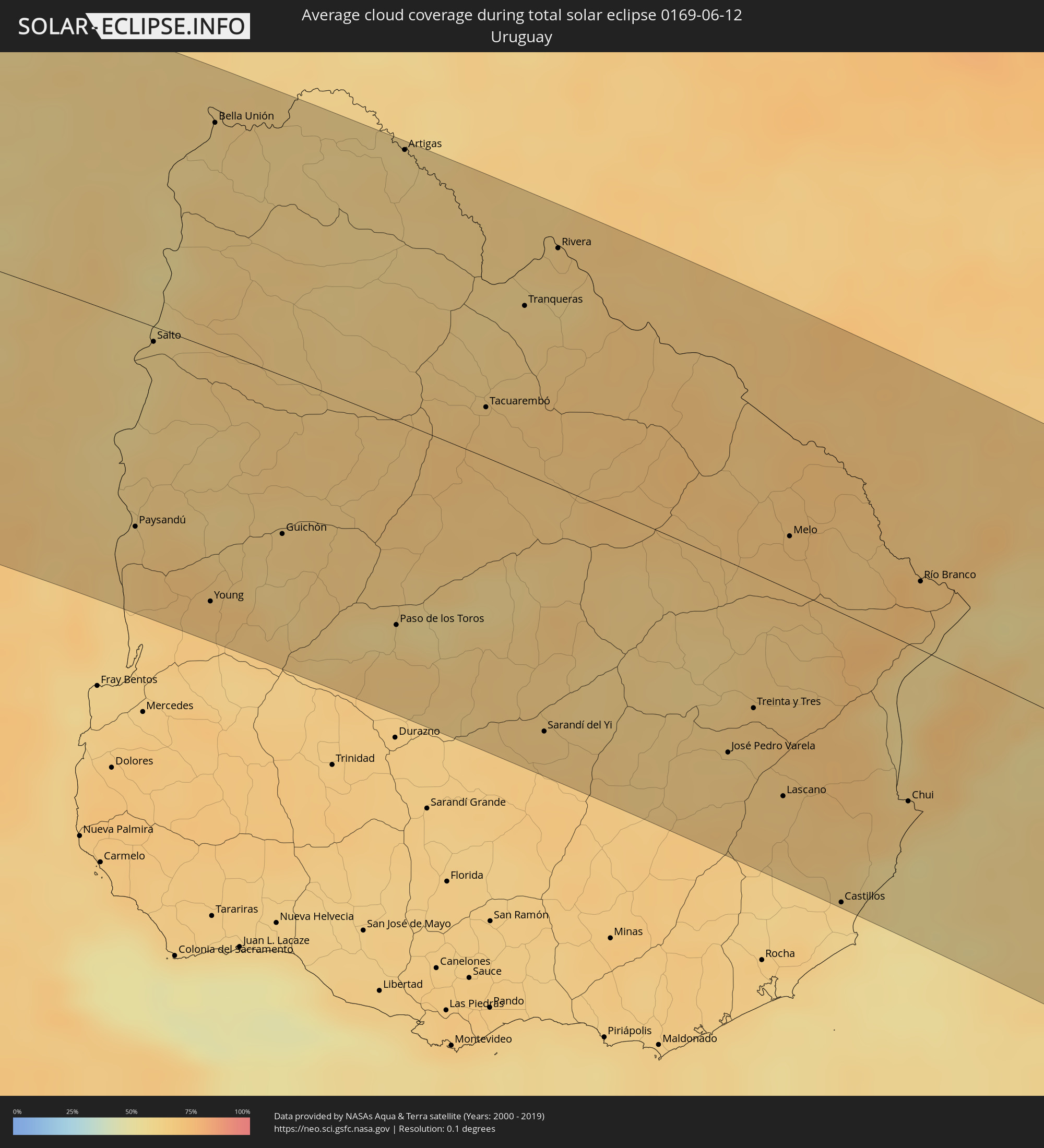 Uruguay
Cities inside the path of the eclipse
The following table shows all locations with a population of more than 5,000 inside the eclipse path. Cities which have more than 100,000 inhabitants are marked bold. A click at the locations opens a detailed map.
| City | Type | Eclipse duration | Local time of max. eclipse | Distance to central line | Ø Cloud coverage |
 Coquimbo, Coquimbo
|
total | - | 11:43:59 UTC-04:42 | 89 km | 68% |
|
La Serena, Coquimbo
|
total | - | 11:44:12 UTC-04:42 | 83 km | 69% |
|
Ovalle, Coquimbo
|
total | - | 11:44:25 UTC-04:42 | 161 km | 60% |
|
Vallenar, Atacama
|
total | - | 11:45:21 UTC-04:42 | 64 km | 55% |
|
Vicuña, Coquimbo
|
total | - | 11:45:37 UTC-04:42 | 98 km | 54% |
 San José de Jáchal, San Juan Province
|
total | - | 12:16:43 UTC-04:16 | 114 km | 46% |
|
Tinogasta, Catamarca Province
|
total | - | 12:19:45 UTC-04:16 | 137 km | 38% |
|
Chilecito, La Rioja Province
|
total | - | 12:19:57 UTC-04:16 | 16 km | 41% |
|
La Rioja, La Rioja Province
|
total | - | 12:21:38 UTC-04:16 | 5 km | 47% |
|
Arauco, La Rioja Province
|
total | - | 12:21:47 UTC-04:16 | 88 km | 46% |
|
Chamical, La Rioja Province
|
total | - | 12:23:00 UTC-04:16 | 102 km | 49% |
|
San Fernando del Valle de Catamarca, Catamarca Province
|
total | - | 12:24:26 UTC-04:16 | 113 km | 47% |
|
Recreo, Catamarca Province
|
total | - | 12:26:17 UTC-04:16 | 35 km | 55% |
|
Cruz del Eje, Cordoba Province
|
total | - | 12:26:50 UTC-04:16 | 118 km | 51% |
|
Capilla del Monte, Cordoba Province
|
total | - | 12:27:31 UTC-04:16 | 128 km | 50% |
|
La Falda, Cordoba Province
|
total | - | 12:27:35 UTC-04:16 | 152 km | 47% |
|
Deán Funes, Cordoba Province
|
total | - | 12:28:00 UTC-04:16 | 76 km | 57% |
|
Río Ceballos, Cordoba Province
|
total | - | 12:28:00 UTC-04:16 | 157 km | 53% |
|
Jesús María, Cordoba Province
|
total | - | 12:28:35 UTC-04:16 | 132 km | 59% |
|
Arroyito, Cordoba Province
|
total | - | 12:31:08 UTC-04:16 | 157 km | 65% |
|
San Francisco, Cordoba Province
|
total | - | 12:33:30 UTC-04:16 | 134 km | 68% |
|
Brinkmann, Cordoba Province
|
total | - | 12:33:42 UTC-04:16 | 73 km | 71% |
|
Morteros, Cordoba Province
|
total | - | 12:33:49 UTC-04:16 | 55 km | 70% |
|
Ceres, Santa Fe Province
|
total | - | 12:34:05 UTC-04:16 | 35 km | 71% |
|
Tostado, Santa Fe Province
|
total | - | 12:34:37 UTC-04:16 | 110 km | 69% |
|
Sunchales, Santa Fe Province
|
total | - | 12:34:51 UTC-04:16 | 69 km | 73% |
|
Rafaela, Santa Fe Province
|
total | - | 12:34:59 UTC-04:16 | 100 km | 72% |
|
San Cristóbal, Santa Fe Province
|
total | - | 12:35:45 UTC-04:16 | 7 km | 66% |
|
San Carlos Centro, Santa Fe Province
|
total | - | 12:35:50 UTC-04:16 | 140 km | 67% |
|
Esperanza, Santa Fe Province
|
total | - | 12:36:16 UTC-04:16 | 106 km | 70% |
|
Recreo, Santa Fe Province
|
total | - | 12:36:44 UTC-04:16 | 105 km | 65% |
|
Santa Fe de la Vera Cruz, Santa Fe Province
|
total | - | 12:36:47 UTC-04:16 | 119 km | 64% |
|
Laguna Paiva, Santa Fe Province
|
total | - | 12:36:57 UTC-04:16 | 83 km | 68% |
|
San Justo, Santa Fe Province
|
total | - | 12:37:13 UTC-04:16 | 26 km | 70% |
|
Paraná, Entre Ríos Province
|
total | - | 12:37:11 UTC-04:16 | 124 km | 64% |
|
Crespo, Entre Ríos Province
|
total | - | 12:37:38 UTC-04:16 | 149 km | 68% |
|
Calchaquí, Santa Fe Province
|
total | - | 12:38:08 UTC-04:16 | 78 km | 67% |
|
Vera, Santa Fe Province
|
total | - | 12:38:24 UTC-04:16 | 126 km | 61% |
|
Viale, Entre Ríos Province
|
total | - | 12:38:22 UTC-04:16 | 123 km | 67% |
|
San Javier, Santa Fe Province
|
total | - | 12:38:51 UTC-04:16 | 15 km | 63% |
|
Santa Elena, Entre Ríos Province
|
total | - | 12:39:07 UTC-04:16 | 20 km | 61% |
|
La Paz, Entre Ríos Province
|
total | - | 12:39:29 UTC-04:16 | 6 km | 58% |
|
Esquina, Corrientes Province
|
total | - | 12:39:56 UTC-04:16 | 87 km | 60% |
|
Bovril, Entre Ríos Province
|
total | - | 12:39:49 UTC-04:16 | 51 km | 62% |
|
Rosario del Tala, Entre Ríos Province
|
total | - | 12:40:16 UTC-04:16 | 142 km | 66% |
|
Villaguay, Entre Ríos Province
|
total | - | 12:40:40 UTC-04:16 | 93 km | 64% |
|
Federal, Entre Ríos Province
|
total | - | 12:41:28 UTC-04:16 | 10 km | 59% |
|
San José de Feliciano, Entre Ríos Province
|
total | - | 12:41:41 UTC-04:16 | 71 km | 58% |
|
San Salvador, Entre Ríos Province
|
total | - | 12:41:56 UTC-04:16 | 51 km | 63% |
|
Villa Elisa, Entre Ríos Province
|
total | - | 12:42:01 UTC-04:16 | 104 km | 64% |
|
Concepción del Uruguay, Entre Ríos Province
|
total | - | 12:42:18 UTC-04:16 | 132 km | 63% |
 Paysandú, Paysandú
|
total | - | 13:14:39 UTC-03:44 | 109 km | 64% |
|
Concordia, Entre Ríos Province
|
total | - | 12:43:06 UTC-04:16 | 11 km | 59% |
|
Chajarí, Entre Ríos Province
|
total | - | 12:43:22 UTC-04:16 | 58 km | 58% |
|
Salto, Salto
|
total | - | 13:15:11 UTC-03:44 | 8 km | 59% |
|
Federación, Entre Ríos Province
|
total | - | 12:43:29 UTC-04:16 | 34 km | 56% |
|
Monte Caseros, Corrientes Province
|
total | - | 12:44:18 UTC-04:16 | 121 km | 61% |
|
Young, Río Negro
|
total | - | 13:15:33 UTC-03:44 | 133 km | 69% |
|
Bella Unión, Artigas
|
total | - | 13:16:20 UTC-03:44 | 121 km | 61% |
|
Guichón, Paysandú
|
total | - | 13:16:37 UTC-03:44 | 83 km | 65% |
|
Paso de los Toros, Tacuarembó
|
total | - | 13:17:57 UTC-03:44 | 106 km | 62% |
|
Artigas, Artigas
|
total | - | 13:18:51 UTC-03:44 | 145 km | 62% |
 Quaraí, Rio Grande do Sul
|
total | - | 13:57:17 UTC-03:06 | 147 km | 62% |
|
Tacuarembó, Tacuarembó
|
total | - | 13:19:30 UTC-03:44 | 26 km | 68% |
|
Tranqueras, Rivera
|
total | - | 13:20:11 UTC-03:44 | 88 km | 62% |
|
Sarandí del Yi, Durazno
|
total | - | 13:19:40 UTC-03:44 | 128 km | 65% |
|
Rivera, Rivera
|
total | - | 13:20:43 UTC-03:44 | 125 km | 64% |
|
Santana do Livramento, Rio Grande do Sul
|
total | - | 13:59:09 UTC-03:06 | 127 km | 65% |
|
José Pedro Varela, Lavalleja
|
total | - | 13:21:56 UTC-03:44 | 97 km | 65% |
|
Treinta y Tres, Treinta y Tres
|
total | - | 13:22:20 UTC-03:44 | 69 km | 67% |
|
Lascano, Rocha
|
total | - | 13:22:31 UTC-03:44 | 106 km | 66% |
|
Melo, Cerro Largo
|
total | - | 13:23:08 UTC-03:44 | 27 km | 71% |
|
Bagé, Rio Grande do Sul
|
total | - | 14:02:03 UTC-03:06 | 135 km | 70% |
|
Castillos, Rocha
|
total | - | 13:23:00 UTC-03:44 | 145 km | 60% |
|
Chui, Rocha
|
total | - | 13:24:01 UTC-03:44 | 79 km | 65% |
|
Chuí, Rio Grande do Sul
|
total | - | 13:24:02 UTC-03:44 | 78 km | 65% |
|
Herval, Rio Grande do Sul
|
total | - | 14:03:15 UTC-03:06 | 92 km | 66% |
|
Río Branco, Cerro Largo
|
total | - | 13:24:39 UTC-03:44 | 35 km | 73% |
|
Pinheiro Machado, Rio Grande do Sul
|
total | - | 14:03:27 UTC-03:06 | 138 km | 68% |
|
Jaguarão, Rio Grande do Sul
|
total | - | 14:03:04 UTC-03:06 | 38 km | 73% |
|
Santa Vitória do Palmar, Rio Grande do Sul
|
total | - | 14:02:40 UTC-03:06 | 58 km | 66% |
|
Arroio Grande, Rio Grande do Sul
|
total | - | 14:03:47 UTC-03:06 | 83 km | 68% |
|
Rio Grande, Rio Grande do Sul
|
total | - | 14:05:52 UTC-03:06 | 143 km | 68% |