Total solar eclipse of 07/26/0203
| Day of week: | Tuesday |
| Maximum duration of eclipse: | 02m09s |
| Maximum width of eclipse path: | 229 km |
| Saros cycle: | 68 |
| Coverage: | 100% |
| Magnitude: | 1.0355 |
| Gamma: | 0.8516 |
Wo kann man die Sonnenfinsternis vom 07/26/0203 sehen?
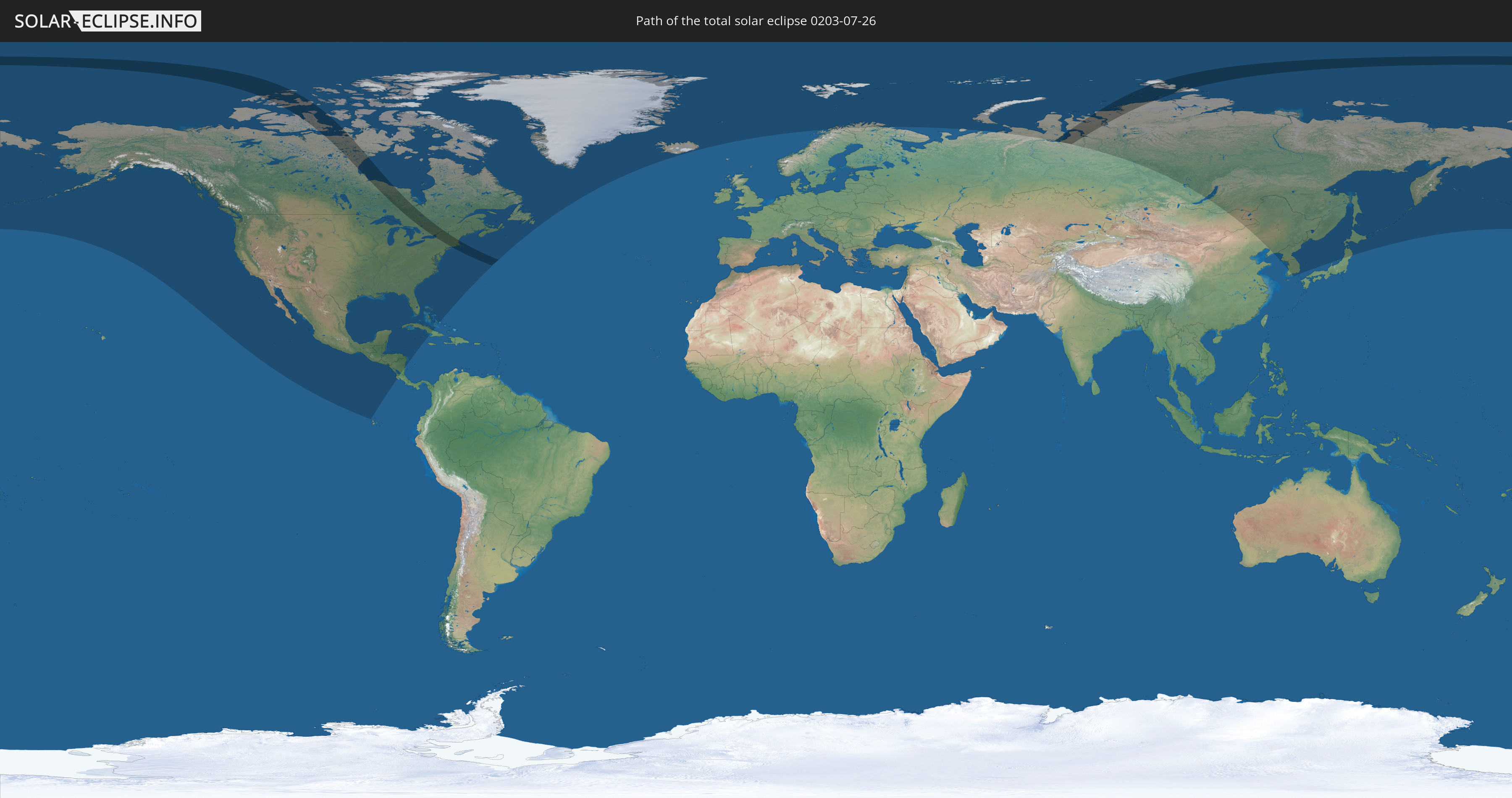
Die Sonnenfinsternis am 07/26/0203 kann man in 25 Ländern als partielle Sonnenfinsternis beobachten.
Der Finsternispfad verläuft durch 3 Länder. Nur in diesen Ländern ist sie als total Sonnenfinsternis zu sehen.
In den folgenden Ländern ist die Sonnenfinsternis total zu sehen
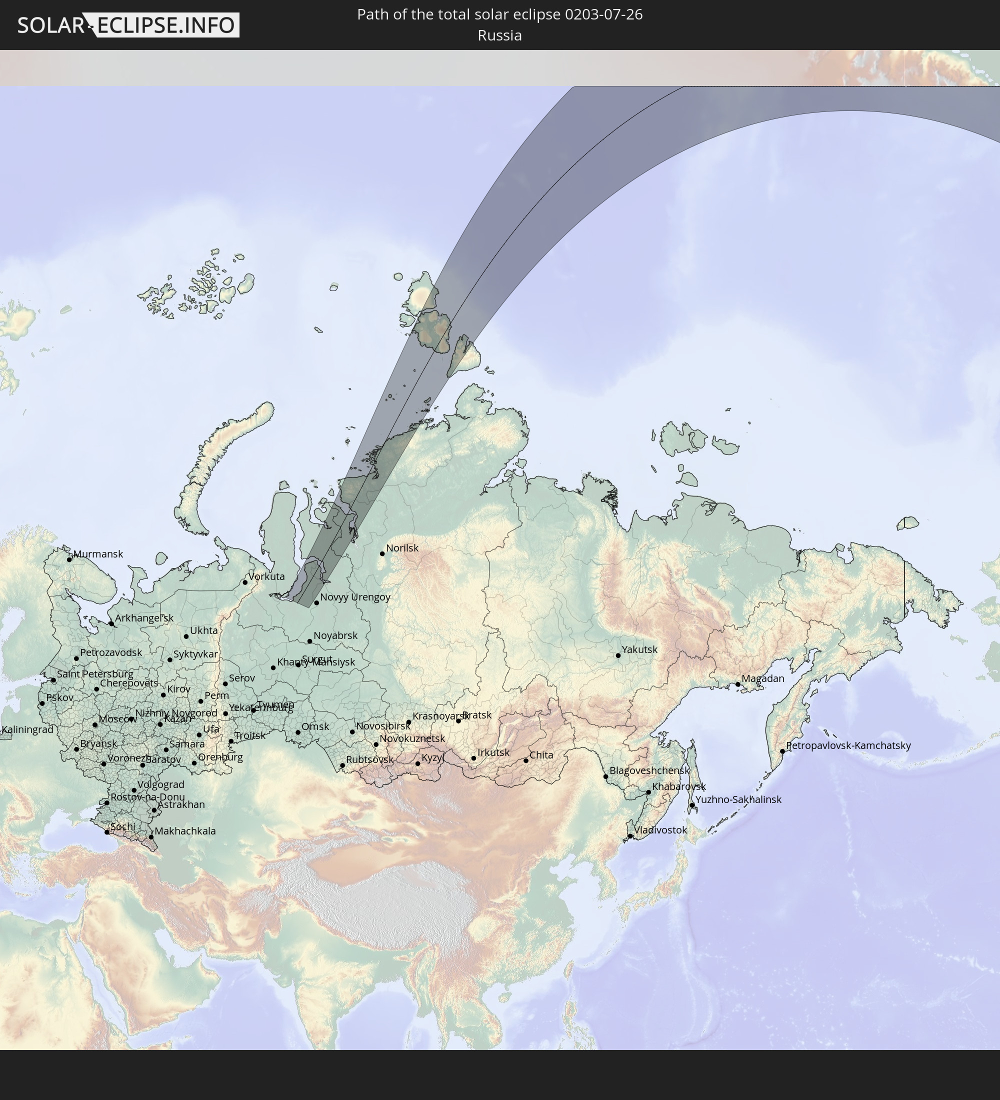 Russia
 United States
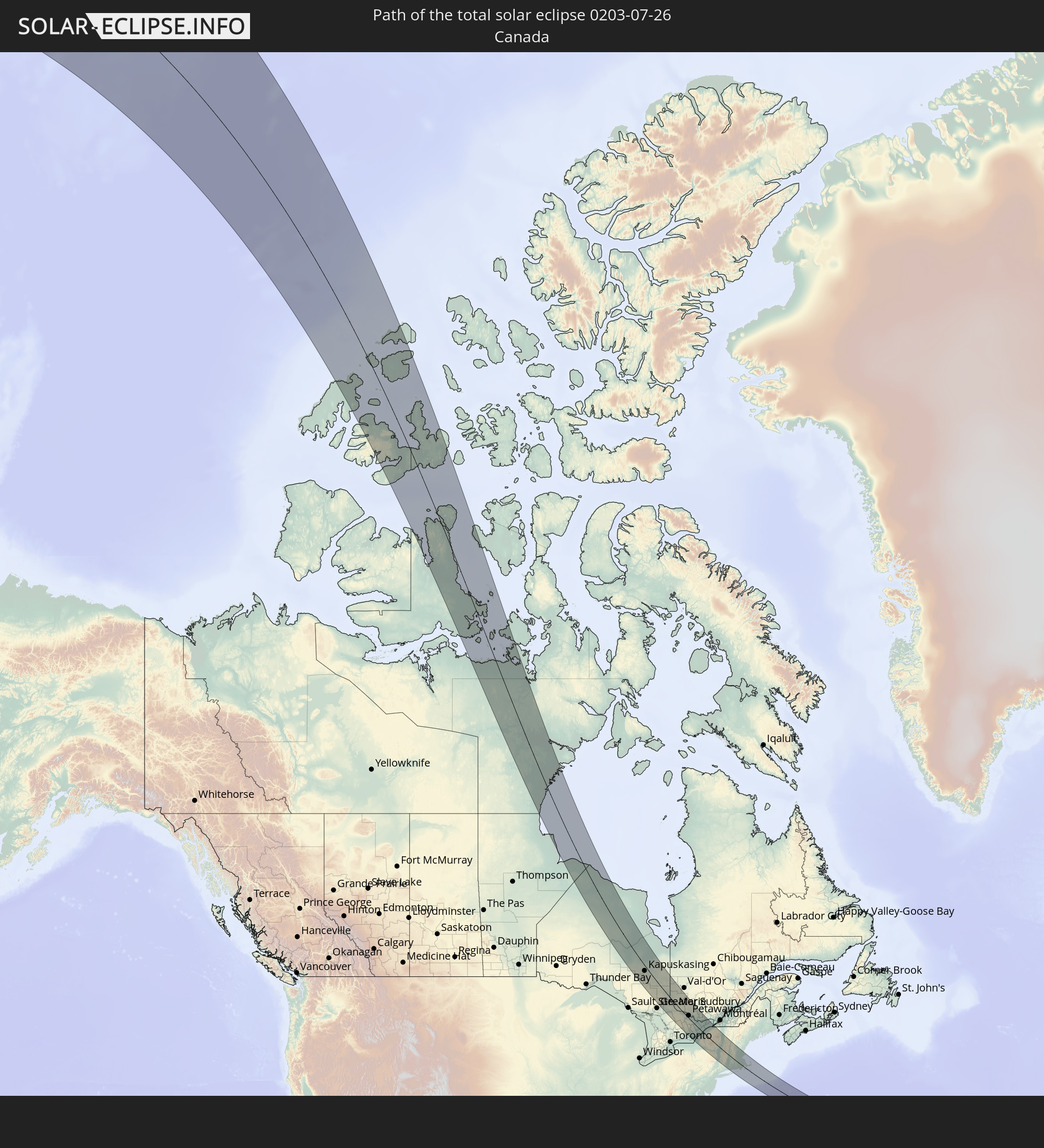 Canada
In den folgenden Ländern ist die Sonnenfinsternis partiell zu sehen


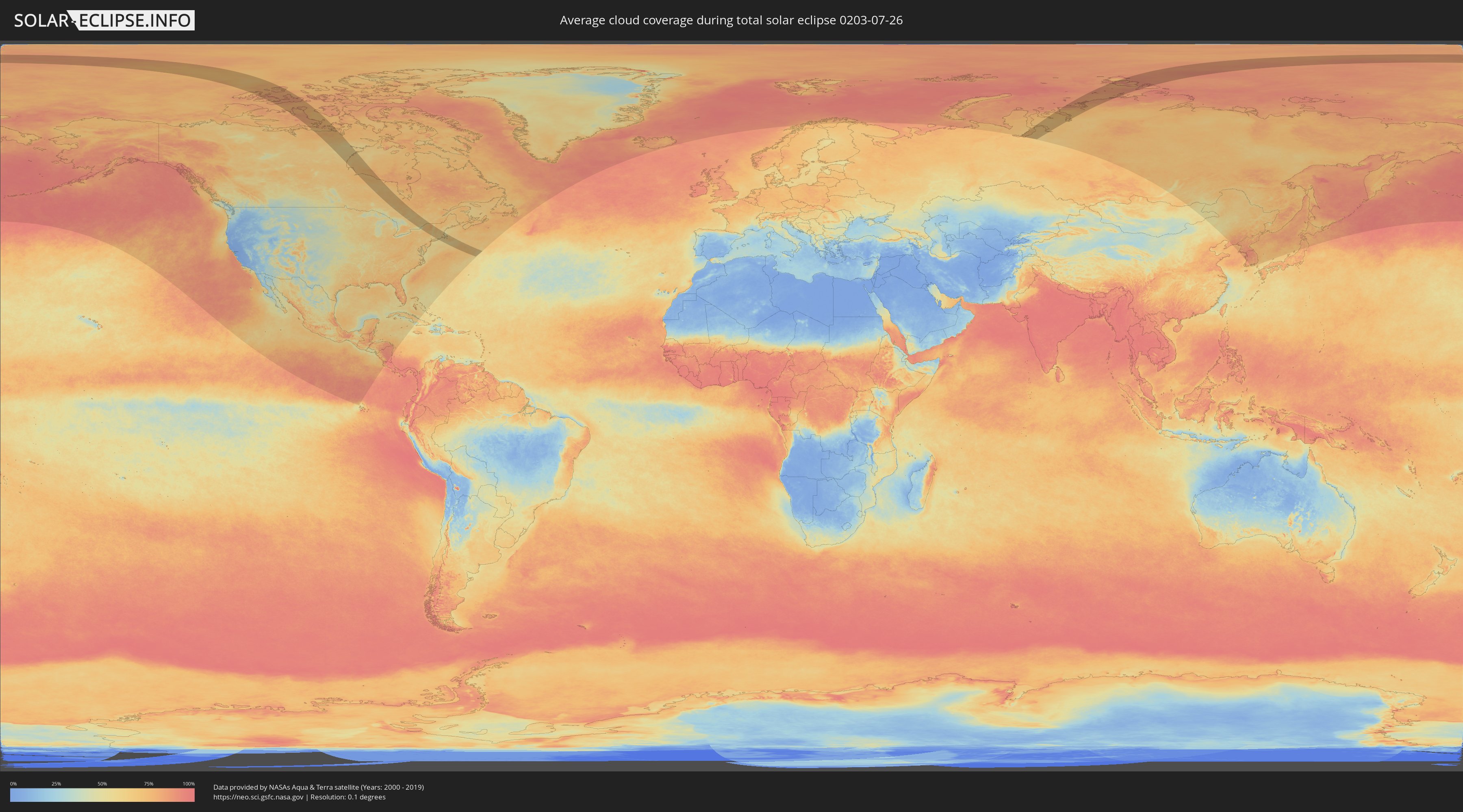
How will be the weather during the total solar eclipse on 07/26/0203?
Where is the best place to see the total solar eclipse of 07/26/0203?
The following maps show the average cloud coverage for the day of the total solar eclipse.
With the help of these maps, it is possible to find the place along the eclipse path, which has the best
chance of a cloudless sky.
Nevertheless, you should consider local circumstances and inform about the weather of your chosen
observation site.
The data is provided by NASAs satellites
AQUA and TERRA.
The cloud maps are averaged over a period of 19 years (2000 - 2019).

Detailed country maps
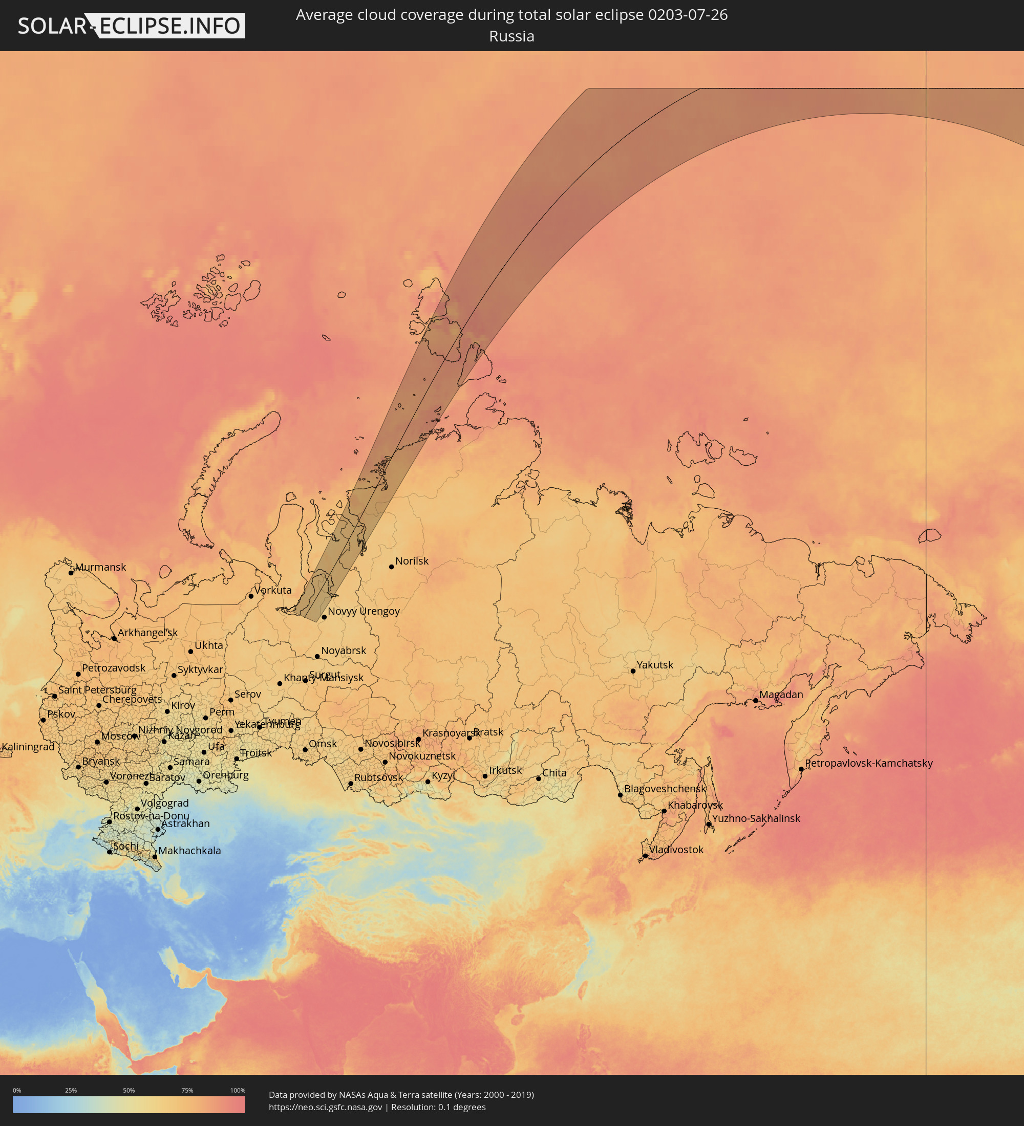 Russia
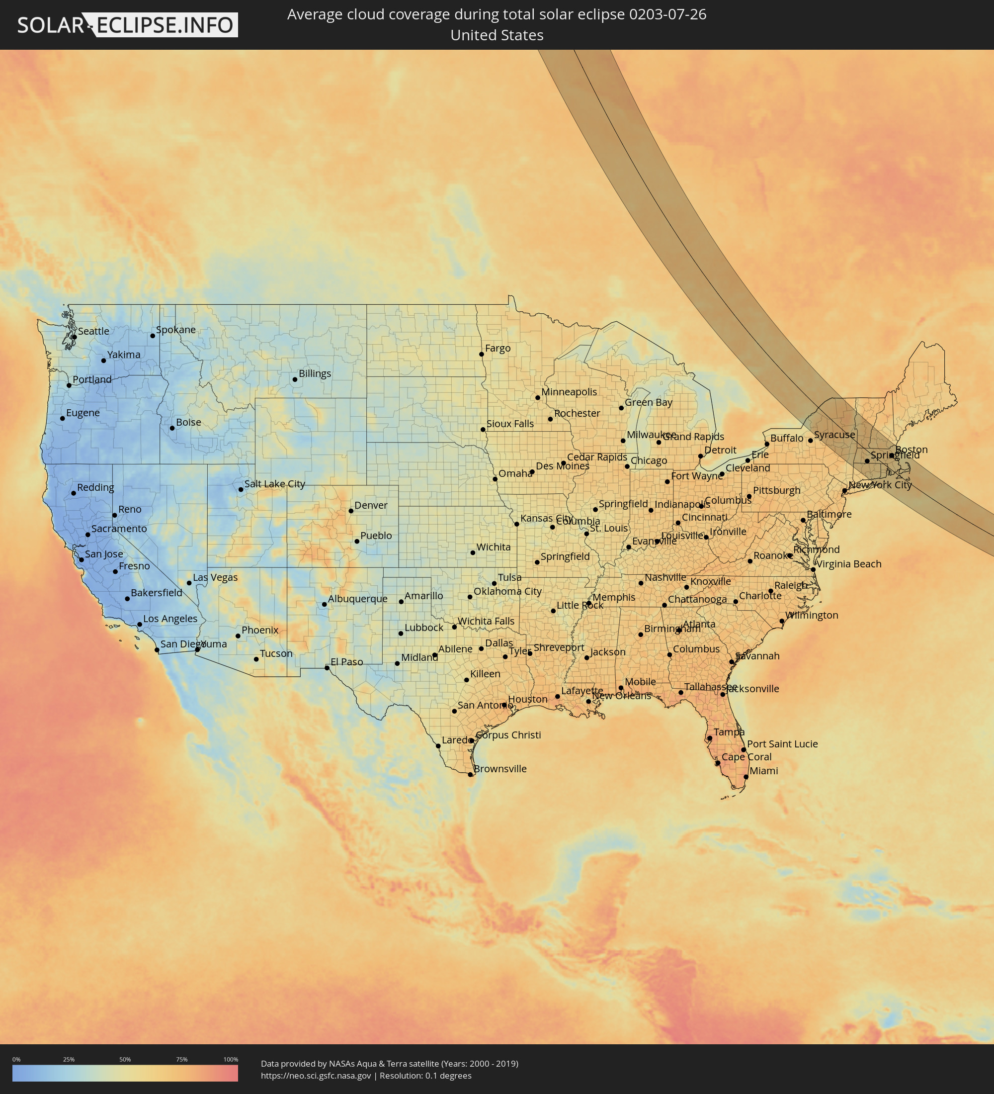 United States
 Canada
Cities inside the path of the eclipse
The following table shows all locations with a population of more than 5,000 inside the eclipse path. Cities which have more than 100,000 inhabitants are marked bold. A click at the locations opens a detailed map.
| City | Type | Eclipse duration | Local time of max. eclipse | Distance to central line | Ø Cloud coverage |
 Kapuskasing, Ontario
|
total | - | 18:04:23 UTC-05:00 | 31 km | 68% |
|
Timmins, Ontario
|
total | - | 18:05:59 UTC-05:00 | 27 km | 67% |
|
Kirkland Lake, Ontario
|
total | - | 18:06:27 UTC-05:00 | 25 km | 66% |
|
Temiskaming Shores, Ontario
|
total | - | 18:07:32 UTC-05:00 | 3 km | 63% |
|
North Bay, Ontario
|
total | - | 18:09:29 UTC-05:00 | 75 km | 51% |
|
La Sarre, Quebec
|
total | - | 18:05:15 UTC-05:00 | 119 km | 68% |
|
Rouyn-Noranda, Quebec
|
total | - | 18:06:11 UTC-05:00 | 90 km | 63% |
|
Petawawa, Ontario
|
total | - | 18:09:53 UTC-05:00 | 16 km | 64% |
|
Pembroke, Ontario
|
total | - | 18:09:59 UTC-05:00 | 19 km | 64% |
|
Greater Napanee, Ontario
|
total | - | 18:12:30 UTC-05:00 | 95 km | 62% |
|
Renfrew, Ontario
|
total | - | 18:10:29 UTC-05:00 | 16 km | 65% |
|
Kingston, Ontario
|
total | - | 18:12:26 UTC-05:00 | 71 km | 49% |
|
Arnprior, Ontario
|
total | - | 18:10:28 UTC-05:00 | 32 km | 65% |
|
Perth, Ontario
|
total | - | 18:11:19 UTC-05:00 | 4 km | 58% |
|
Gananoque, Ontario
|
total | - | 18:12:13 UTC-05:00 | 45 km | 50% |
|
Carleton Place, Ontario
|
total | - | 18:10:55 UTC-05:00 | 20 km | 65% |
|
Smiths Falls, Ontario
|
total | - | 18:11:16 UTC-05:00 | 9 km | 63% |
 Watertown, New York
|
total | - | 18:12:44 UTC-05:00 | 60 km | 67% |
|
Bells Corners, Ontario
|
total | - | 18:10:34 UTC-05:00 | 52 km | 64% |
|
le Plateau, Quebec
|
total | - | 18:10:22 UTC-05:00 | 64 km | 63% |
|
Fort Drum, New York
|
total | - | 18:12:34 UTC-05:00 | 45 km | 64% |
|
Gatineau, Quebec
|
total | - | 18:10:17 UTC-05:00 | 72 km | 66% |
|
Ottawa, Ontario
|
total | - | 18:10:23 UTC-05:00 | 67 km | 66% |
|
Brockville, Ontario
|
total | - | 18:11:42 UTC-05:00 | 2 km | 61% |
|
Val-des-Monts, Quebec
|
total | - | 18:09:59 UTC-05:00 | 87 km | 61% |
|
Ogdensburg, New York
|
total | - | 18:11:30 UTC-05:00 | 21 km | 62% |
|
Rome, New York
|
total | - | 18:13:51 UTC-05:00 | 98 km | 64% |
|
Clarence-Rockland, Ontario
|
total | - | 18:10:05 UTC-05:00 | 100 km | 62% |
|
Utica, New York
|
total | - | 18:13:58 UTC-05:00 | 96 km | 69% |
|
Ilion, New York
|
total | - | 18:14:03 UTC-05:00 | 92 km | 69% |
|
Herkimer, New York
|
total | - | 18:14:02 UTC-05:00 | 89 km | 69% |
|
Potsdam, New York
|
total | - | 18:11:26 UTC-05:00 | 47 km | 65% |
|
Massena, New York
|
total | - | 18:11:00 UTC-05:00 | 73 km | 65% |
|
Cornwall, Ontario
|
total | - | 18:10:49 UTC-05:00 | 89 km | 62% |
|
Gloversville, New York
|
total | - | 18:13:50 UTC-05:00 | 52 km | 66% |
|
Amsterdam, New York
|
total | - | 18:13:58 UTC-05:00 | 54 km | 63% |
|
Scotia, New York
|
total | - | 18:14:05 UTC-05:00 | 51 km | 67% |
|
Schenectady, New York
|
total | - | 18:14:06 UTC-05:00 | 51 km | 65% |
|
Colonie, New York
|
total | - | 18:14:13 UTC-05:00 | 54 km | 65% |
|
Saratoga Springs, New York
|
total | - | 18:13:39 UTC-05:00 | 20 km | 63% |
|
Oakdale, New York
|
total | - | 18:14:56 UTC-05:00 | 91 km | 58% |
|
Albany, New York
|
total | - | 18:14:18 UTC-05:00 | 55 km | 65% |
|
Glens Falls, New York
|
total | - | 18:13:15 UTC-05:00 | 7 km | 61% |
|
Pittsfield, Massachusetts
|
total | - | 18:14:29 UTC-05:00 | 46 km | 59% |
|
Bennington, Vermont
|
total | - | 18:13:49 UTC-05:00 | 7 km | 68% |
|
Torrington, Connecticut
|
total | - | 18:15:26 UTC-05:00 | 96 km | 66% |
|
North Adams, Massachusetts
|
total | - | 18:14:04 UTC-05:00 | 17 km | 64% |
|
Winsted, Connecticut
|
total | - | 18:15:14 UTC-05:00 | 82 km | 64% |
|
Rutland, Vermont
|
total | - | 18:12:37 UTC-05:00 | 67 km | 66% |
|
Bristol, Connecticut
|
total | - | 18:15:35 UTC-05:00 | 98 km | 66% |
|
Meriden, Connecticut
|
total | - | 18:15:45 UTC-05:00 | 102 km | 62% |
|
Southwick, Massachusetts
|
total | - | 18:14:57 UTC-05:00 | 55 km | 61% |
|
Hartford, Connecticut
|
total | - | 18:15:22 UTC-05:00 | 76 km | 66% |
|
Northampton, Massachusetts
|
total | - | 18:14:30 UTC-05:00 | 25 km | 62% |
|
Windsor Locks, Connecticut
|
total | - | 18:15:06 UTC-05:00 | 59 km | 64% |
|
Greenfield, Massachusetts
|
total | - | 18:14:06 UTC-05:00 | 0 km | 58% |
|
Springfield, Massachusetts
|
total | - | 18:14:50 UTC-05:00 | 42 km | 63% |
|
Southwood Acres, Connecticut
|
total | - | 18:15:02 UTC-05:00 | 53 km | 63% |
|
East Haddam, Connecticut
|
total | - | 18:15:47 UTC-05:00 | 92 km | 58% |
|
Rockville, Connecticut
|
total | - | 18:15:09 UTC-05:00 | 55 km | 61% |
|
Old Saybrook, Connecticut
|
total | - | 18:16:00 UTC-05:00 | 102 km | 60% |
|
Tolland, Connecticut
|
total | - | 18:15:07 UTC-05:00 | 51 km | 61% |
|
Hebron, Connecticut
|
total | - | 18:15:26 UTC-05:00 | 69 km | 62% |
|
Claremont, New Hampshire
|
total | - | 18:12:49 UTC-05:00 | 80 km | 64% |
|
Palmer, Massachusetts
|
total | - | 18:14:40 UTC-05:00 | 24 km | 64% |
|
Keene, New Hampshire
|
total | - | 18:13:28 UTC-05:00 | 46 km | 63% |
|
Lebanon, New Hampshire
|
total | - | 18:12:23 UTC-05:00 | 108 km | 68% |
|
Mansfield City, Connecticut
|
total | - | 18:15:14 UTC-05:00 | 53 km | 63% |
|
Athol, Massachusetts
|
total | - | 18:13:58 UTC-05:00 | 20 km | 61% |
|
New London, Connecticut
|
total | - | 18:15:49 UTC-05:00 | 82 km | 57% |
|
Norwich, Connecticut
|
total | - | 18:15:33 UTC-05:00 | 66 km | 55% |
|
Southbridge, Massachusetts
|
total | - | 18:14:43 UTC-05:00 | 16 km | 61% |
|
Gardner, Massachusetts
|
total | - | 18:13:56 UTC-05:00 | 30 km | 63% |
|
Plainfield, Connecticut
|
total | - | 18:15:17 UTC-05:00 | 45 km | 60% |
|
Killingly Center, Connecticut
|
total | - | 18:15:01 UTC-05:00 | 28 km | 64% |
|
Westerly, Rhode Island
|
total | - | 18:15:42 UTC-05:00 | 67 km | 59% |
|
Worcester, Massachusetts
|
total | - | 18:14:21 UTC-05:00 | 12 km | 62% |
|
West Boylston, Massachusetts
|
total | - | 18:14:12 UTC-05:00 | 22 km | 61% |
|
Leominster, Massachusetts
|
total | - | 18:13:57 UTC-05:00 | 37 km | 62% |
|
Weare, New Hampshire
|
total | - | 18:13:04 UTC-05:00 | 88 km | 66% |
|
Coventry, Rhode Island
|
total | - | 18:15:10 UTC-05:00 | 31 km | 59% |
|
Lancaster, Massachusetts
|
total | - | 18:14:02 UTC-05:00 | 36 km | 63% |
|
Milford, New Hampshire
|
total | - | 18:13:27 UTC-05:00 | 70 km | 66% |
|
Charlestown, Rhode Island
|
total | - | 18:15:38 UTC-05:00 | 57 km | 59% |
|
Hollis, New Hampshire
|
total | - | 18:13:34 UTC-05:00 | 65 km | 65% |
|
Hudson, Massachusetts
|
total | - | 18:14:06 UTC-05:00 | 36 km | 64% |
|
Concord, New Hampshire
|
total | - | 18:12:51 UTC-05:00 | 108 km | 65% |
|
Milford, Massachusetts
|
total | - | 18:14:27 UTC-05:00 | 16 km | 63% |
|
Woonsocket, Rhode Island
|
total | - | 18:14:40 UTC-05:00 | 4 km | 61% |
|
Nashua, New Hampshire
|
total | - | 18:13:30 UTC-05:00 | 73 km | 66% |
|
Cumberland Hill, Rhode Island
|
total | - | 18:14:41 UTC-05:00 | 4 km | 61% |
|
North Kingstown, Rhode Island
|
total | - | 18:15:20 UTC-05:00 | 33 km | 57% |
|
Manchester, New Hampshire
|
total | - | 18:13:09 UTC-05:00 | 94 km | 66% |
|
Acton, Massachusetts
|
total | - | 18:13:55 UTC-05:00 | 51 km | 66% |
|
Framingham, Massachusetts
|
total | - | 18:14:13 UTC-05:00 | 33 km | 64% |
|
Providence, Rhode Island
|
total | - | 18:14:54 UTC-05:00 | 6 km | 63% |
|
Plainville, Massachusetts
|
total | - | 18:14:36 UTC-05:00 | 14 km | 63% |
|
Norfolk, Massachusetts
|
total | - | 18:14:26 UTC-05:00 | 24 km | 62% |
|
Lowell, Massachusetts
|
total | - | 18:13:39 UTC-05:00 | 70 km | 66% |
|
Derry Village, New Hampshire
|
total | - | 18:13:16 UTC-05:00 | 92 km | 62% |
|
Newport East, Rhode Island
|
total | - | 18:15:19 UTC-05:00 | 27 km | 60% |
|
Attleboro, Massachusetts
|
total | - | 18:14:41 UTC-05:00 | 11 km | 62% |
|
Needham, Massachusetts
|
total | - | 18:14:09 UTC-05:00 | 43 km | 64% |
|
Tiverton, Rhode Island
|
total | - | 18:15:08 UTC-05:00 | 14 km | 55% |
|
Fall River, Massachusetts
|
total | - | 18:15:00 UTC-05:00 | 4 km | 56% |
|
Woburn, Massachusetts
|
total | - | 18:13:50 UTC-05:00 | 64 km | 66% |
|
Plaistow, New Hampshire
|
total | - | 18:13:17 UTC-05:00 | 99 km | 60% |
|
Taunton, Massachusetts
|
total | - | 18:14:41 UTC-05:00 | 17 km | 59% |
|
Haverhill, Massachusetts
|
total | - | 18:13:22 UTC-05:00 | 94 km | 60% |
|
Boston, Massachusetts
|
total | - | 18:13:59 UTC-05:00 | 59 km | 63% |
|
Brockton, Massachusetts
|
total | - | 18:14:23 UTC-05:00 | 36 km | 61% |
|
Middleton, Massachusetts
|
total | - | 18:13:37 UTC-05:00 | 81 km | 60% |
|
Bridgewater, Massachusetts
|
total | - | 18:14:31 UTC-05:00 | 30 km | 60% |
|
Lynn, Massachusetts
|
total | - | 18:13:48 UTC-05:00 | 74 km | 61% |
|
Weymouth, Massachusetts
|
total | - | 18:14:10 UTC-05:00 | 52 km | 60% |
|
New Bedford, Massachusetts
|
total | - | 18:15:02 UTC-05:00 | 1 km | 60% |
|
Amesbury, Massachusetts
|
total | - | 18:13:12 UTC-05:00 | 109 km | 57% |
|
Halifax, Massachusetts
|
total | - | 18:14:29 UTC-05:00 | 36 km | 60% |
|
Hanover, Massachusetts
|
total | - | 18:14:17 UTC-05:00 | 49 km | 56% |
|
Kingston, Massachusetts
|
total | - | 18:14:26 UTC-05:00 | 43 km | 58% |
|
Plymouth, Massachusetts
|
total | - | 18:14:28 UTC-05:00 | 43 km | 58% |
|
Gloucester, Massachusetts
|
total | - | 18:13:29 UTC-05:00 | 101 km | 57% |
|
Mashpee, Massachusetts
|
total | - | 18:14:52 UTC-05:00 | 29 km | 61% |
|
Barnstable, Massachusetts
|
total | - | 18:14:44 UTC-05:00 | 39 km | 60% |
|
Harwich, Massachusetts
|
total | - | 18:14:41 UTC-05:00 | 49 km | 63% |