Total solar eclipse of 07/05/0232
| Day of week: | Thursday |
| Maximum duration of eclipse: | 03m44s |
| Maximum width of eclipse path: | 199 km |
| Saros cycle: | 69 |
| Coverage: | 100% |
| Magnitude: | 1.0389 |
| Gamma: | -0.7547 |
Wo kann man die Sonnenfinsternis vom 07/05/0232 sehen?

Die Sonnenfinsternis am 07/05/0232 kann man in 24 Ländern als partielle Sonnenfinsternis beobachten.
Der Finsternispfad verläuft durch 4 Länder. Nur in diesen Ländern ist sie als total Sonnenfinsternis zu sehen.
In den folgenden Ländern ist die Sonnenfinsternis total zu sehen
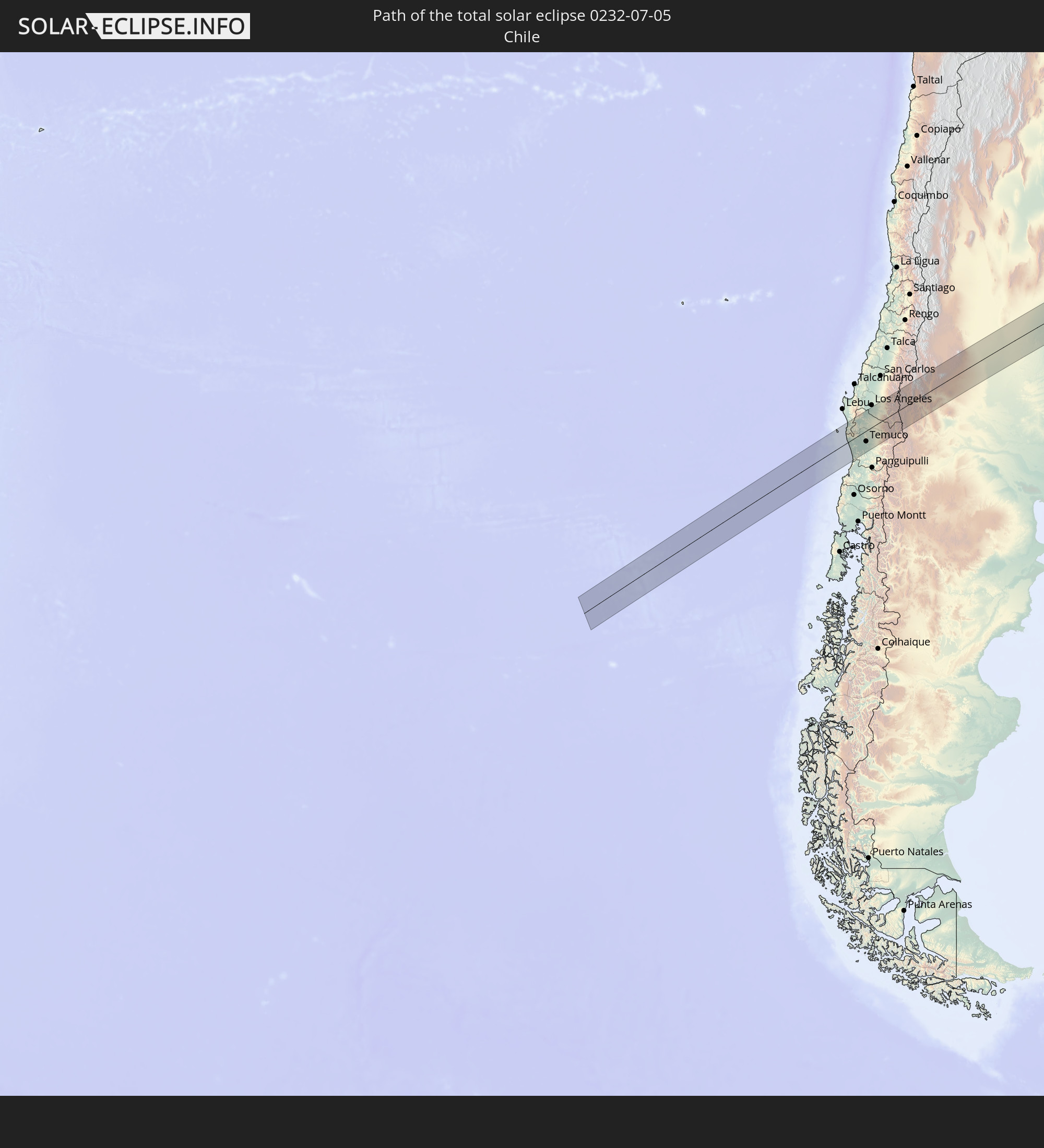 Chile
Chile
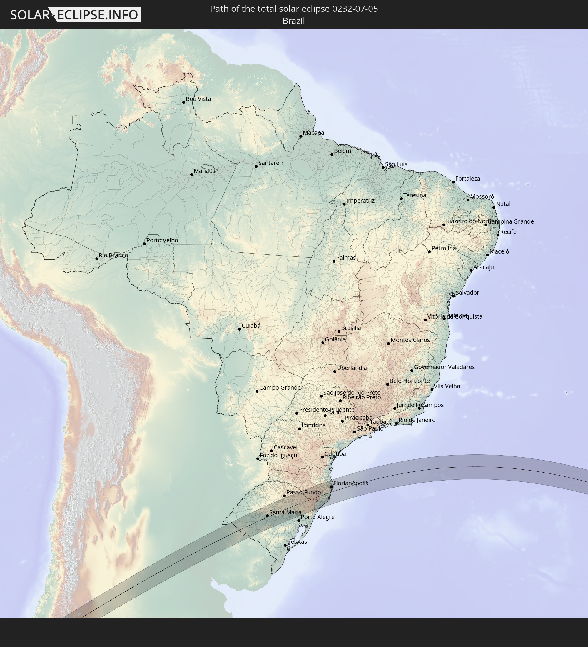 Brazil
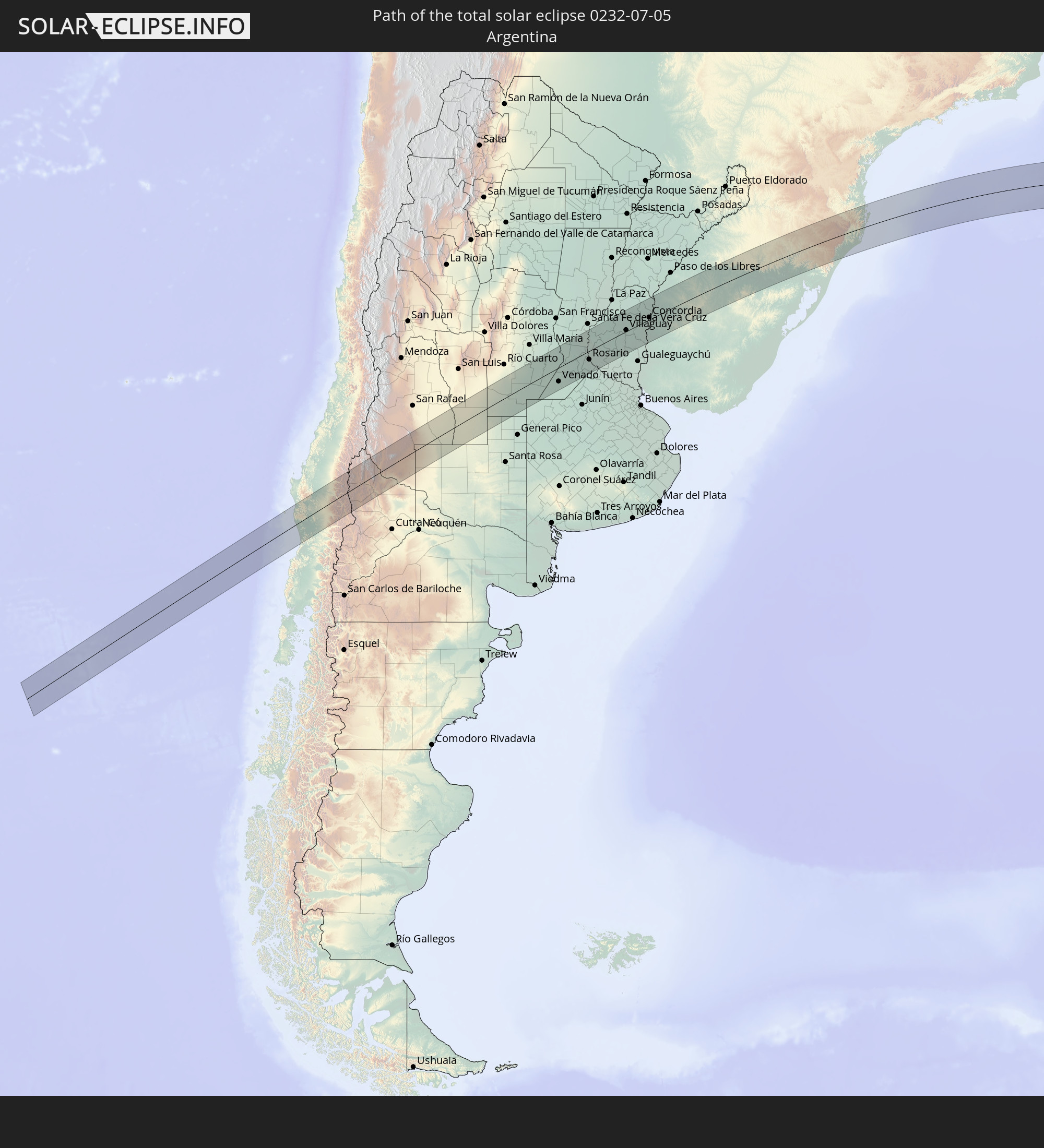 Argentina
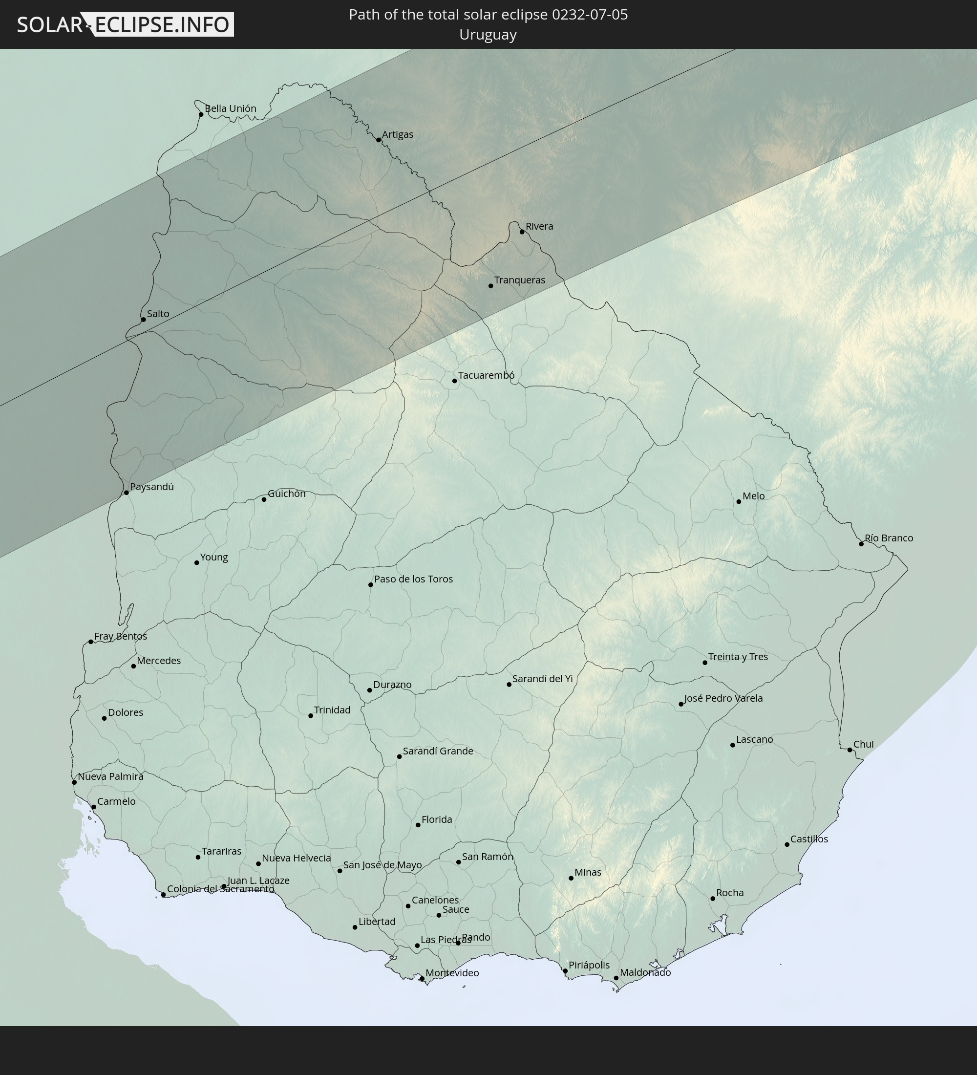 Uruguay
In den folgenden Ländern ist die Sonnenfinsternis partiell zu sehen
 Antarctica
 Chile
Chile
 Ecuador
 Colombia
 Peru
Peru
 Brazil
 Argentina
 Venezuela
 Bolivia
 Paraguay
 Falkland Islands
 Guyana
 Uruguay
 Suriname
 French Guiana
 South Georgia and the South Sandwich Islands
 Saint Helena, Ascension and Tristan da Cunha
 Bouvet Island
 Angola
 Namibia
 Democratic Republic of the Congo
 South Africa
 Botswana
 Zambia
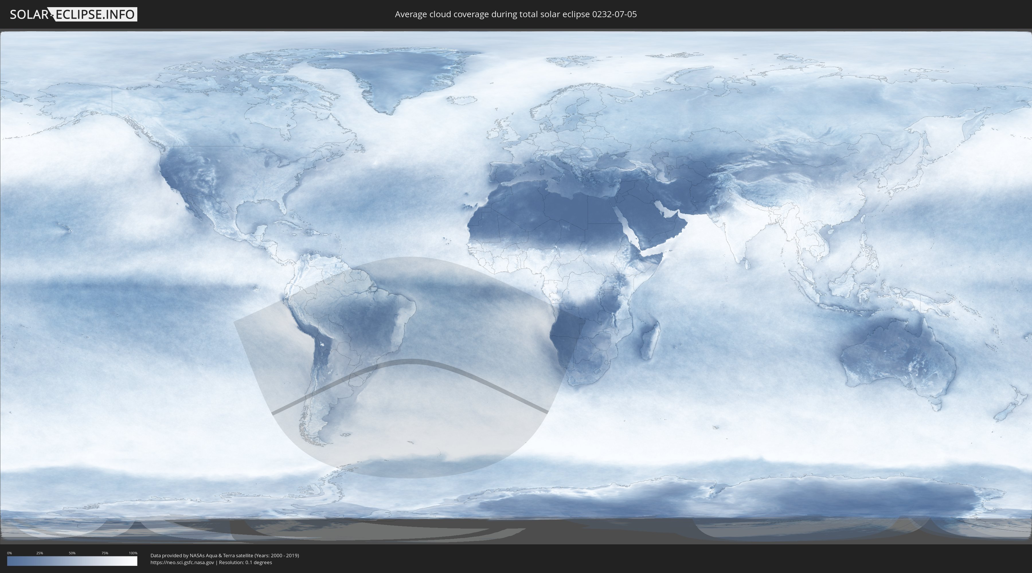
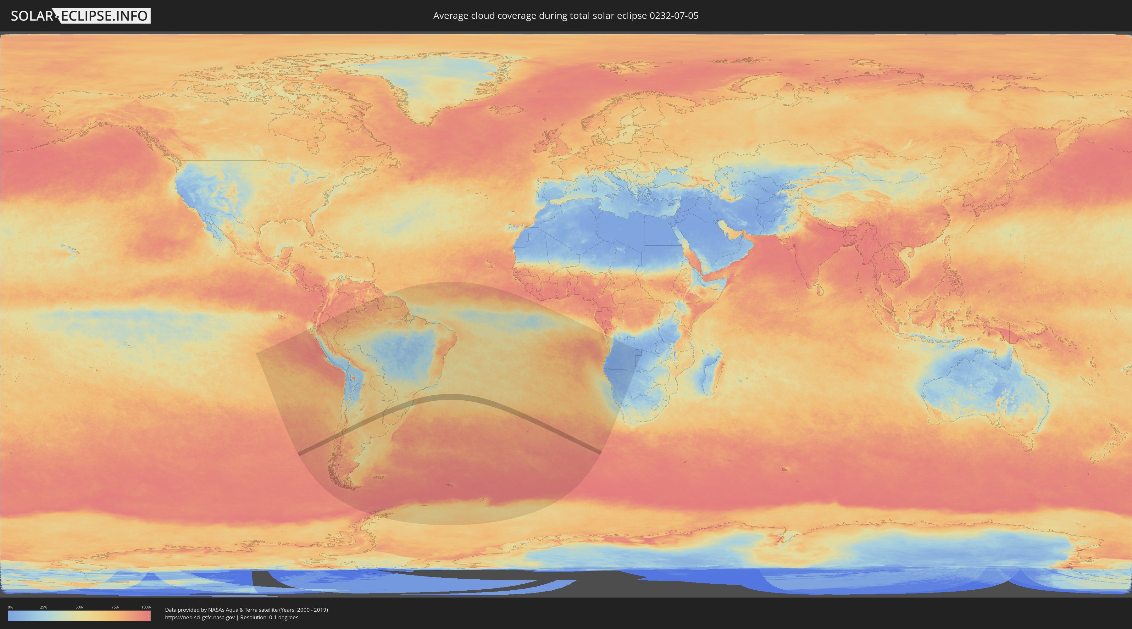
How will be the weather during the total solar eclipse on 07/05/0232?
Where is the best place to see the total solar eclipse of 07/05/0232?
The following maps show the average cloud coverage for the day of the total solar eclipse.
With the help of these maps, it is possible to find the place along the eclipse path, which has the best
chance of a cloudless sky.
Nevertheless, you should consider local circumstances and inform about the weather of your chosen
observation site.
The data is provided by NASAs satellites
AQUA and TERRA.
The cloud maps are averaged over a period of 19 years (2000 - 2019).
Detailed country maps
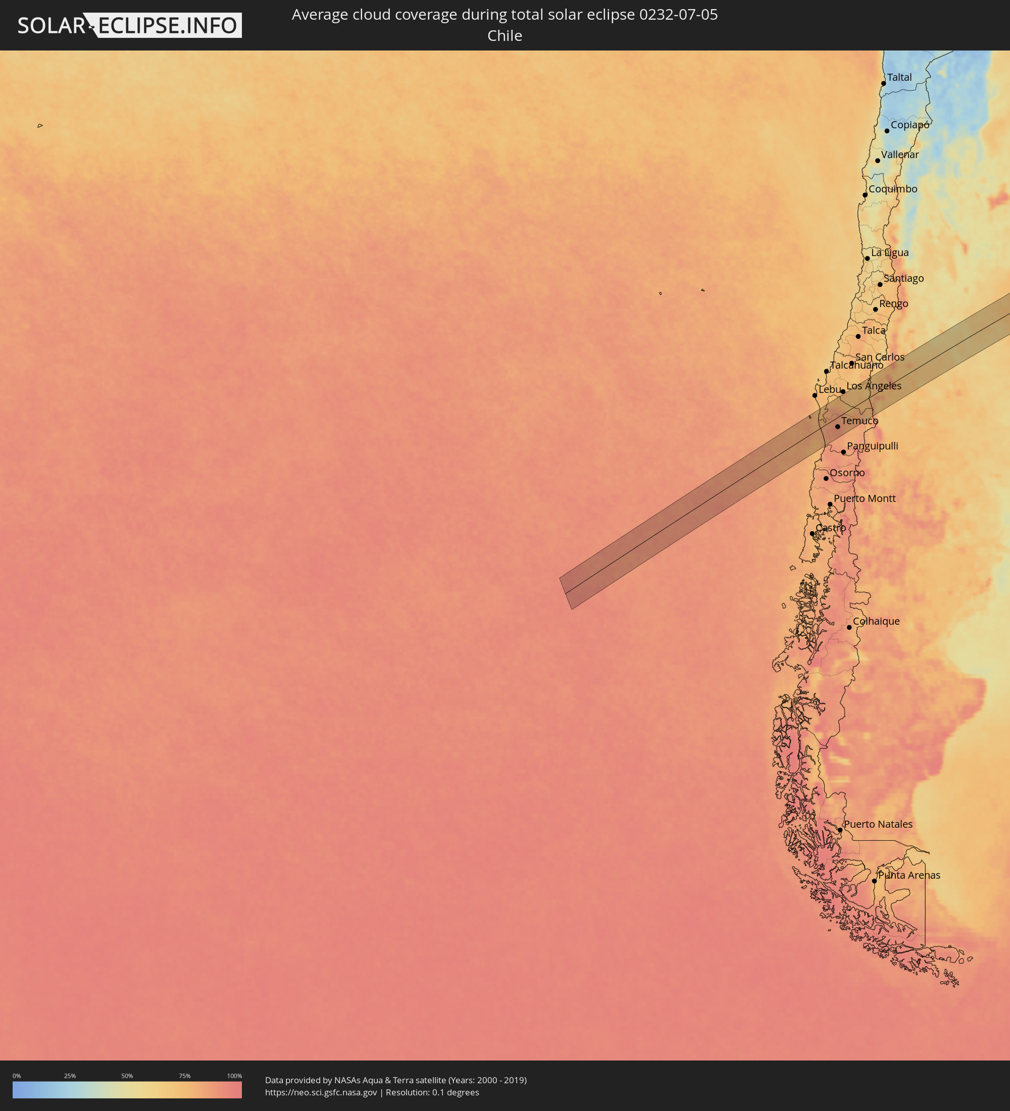 Chile
Chile
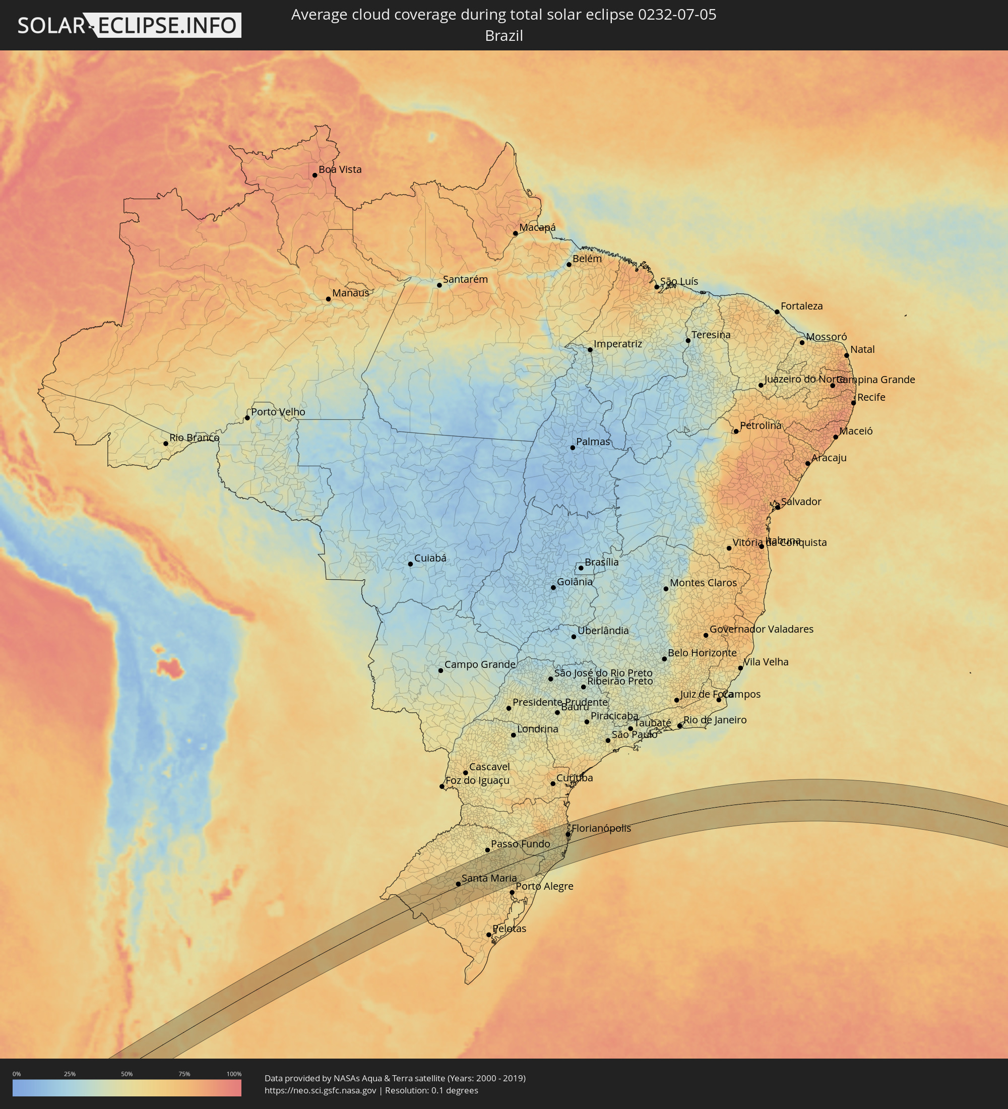 Brazil
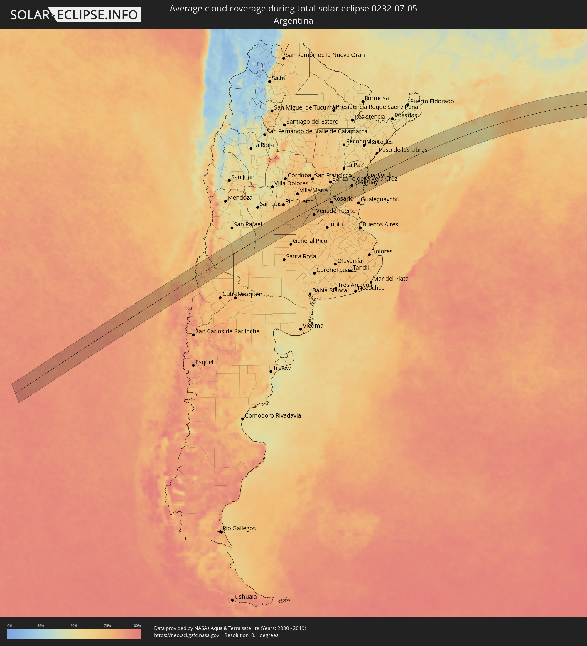 Argentina
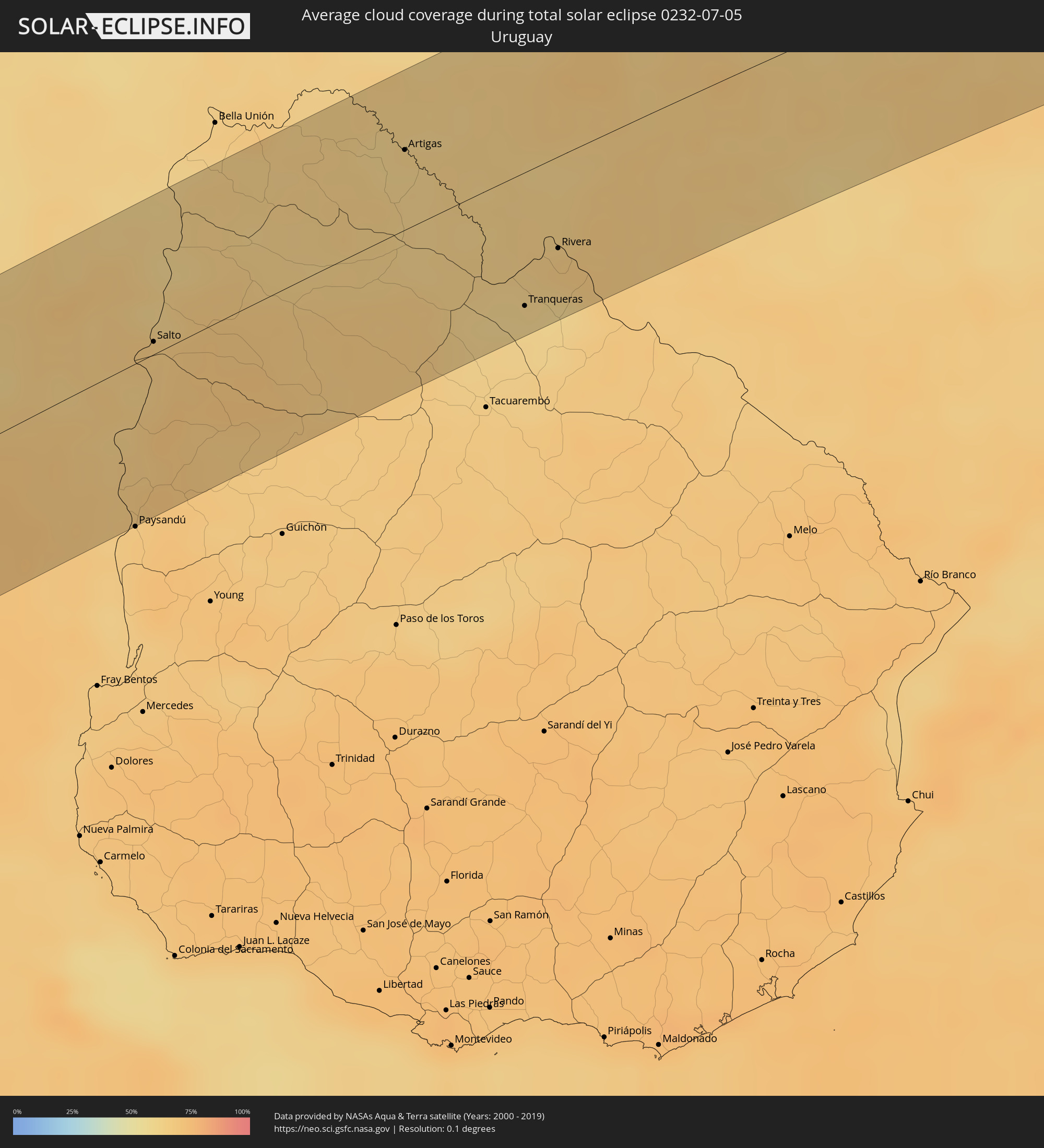 Uruguay
Cities inside the path of the eclipse
The following table shows all locations with a population of more than 5,000 inside the eclipse path. Cities which have more than 100,000 inhabitants are marked bold. A click at the locations opens a detailed map.
| City | Type | Eclipse duration | Local time of max. eclipse | Distance to central line | Ø Cloud coverage |
|
Carahue, Araucanía
|
total | - | 08:40:37 UTC-04:42 | 6 km | 84% |
|
Nueva Imperial, Araucanía
|
total | - | 08:40:52 UTC-04:42 | 19 km | 85% |
|
Angol, Araucanía
|
total | - | 08:40:13 UTC-04:42 | 59 km | 76% |
|
Traiguén, Araucanía
|
total | - | 08:40:41 UTC-04:42 | 14 km | 84% |
|
Pitrufquén, Araucanía
|
total | - | 08:41:25 UTC-04:42 | 57 km | 85% |
|
Freire, Araucanía
|
total | - | 08:41:24 UTC-04:42 | 54 km | 85% |
|
Temuco, Araucanía
|
total | - | 08:41:13 UTC-04:42 | 35 km | 88% |
|
Lautaro, Araucanía
|
total | - | 08:41:12 UTC-04:42 | 23 km | 84% |
|
Collipulli, Araucanía
|
total | - | 08:40:40 UTC-04:42 | 31 km | 79% |
|
Victoria, Araucanía
|
total | - | 08:41:02 UTC-04:42 | 0 km | 82% |
|
Mulchén, Biobío
|
total | - | 08:40:39 UTC-04:42 | 45 km | 72% |
|
Vilcún, Araucanía
|
total | - | 08:41:33 UTC-04:42 | 46 km | 82% |
|
Chos Malal, Neuquén Province
|
total | - | 09:08:31 UTC-04:16 | 15 km | 71% |
|
Vicuña Mackenna, Cordoba Province
|
total | - | 09:13:29 UTC-04:16 | 44 km | 73% |
|
Huinca Renancó, Cordoba Province
|
total | - | 09:14:11 UTC-04:16 | 45 km | 72% |
|
Realicó, La Pampa Province
|
total | - | 09:14:32 UTC-04:16 | 70 km | 71% |
|
Adelia María, Cordoba Province
|
total | - | 09:13:50 UTC-04:16 | 55 km | 71% |
|
Laboulaye, Cordoba Province
|
total | - | 09:15:09 UTC-04:16 | 21 km | 75% |
|
La Carlota, Cordoba Province
|
total | - | 09:14:48 UTC-04:16 | 43 km | 74% |
|
Canals, Cordoba Province
|
total | - | 09:15:32 UTC-04:16 | 10 km | 73% |
|
Rufino, Santa Fe Province
|
total | - | 09:16:18 UTC-04:16 | 66 km | 73% |
|
Justiniano Posse, Cordoba Province
|
total | - | 09:15:25 UTC-04:16 | 67 km | 70% |
|
Monte Maíz, Cordoba Province
|
total | - | 09:15:45 UTC-04:16 | 32 km | 72% |
|
Arias, Cordoba Province
|
total | - | 09:16:22 UTC-04:16 | 20 km | 72% |
|
Leones, Cordoba Province
|
total | - | 09:15:53 UTC-04:16 | 71 km | 73% |
|
Corral de Bustos, Cordoba Province
|
total | - | 09:16:28 UTC-04:16 | 6 km | 74% |
|
Marcos Juárez, Cordoba Province
|
total | - | 09:16:13 UTC-04:16 | 59 km | 72% |
|
Venado Tuerto, Santa Fe Province
|
total | - | 09:17:08 UTC-04:16 | 49 km | 71% |
|
Cruz Alta, Cordoba Province
|
total | - | 09:16:54 UTC-04:16 | 15 km | 72% |
|
Armstrong, Santa Fe Province
|
total | - | 09:17:05 UTC-04:16 | 28 km | 72% |
|
Las Rosas, Santa Fe Province
|
total | - | 09:16:56 UTC-04:16 | 57 km | 70% |
|
Las Parejas, Santa Fe Province
|
total | - | 09:17:10 UTC-04:16 | 34 km | 73% |
|
Firmat, Santa Fe Province
|
total | - | 09:17:44 UTC-04:16 | 43 km | 70% |
|
Cañada de Gómez, Santa Fe Province
|
total | - | 09:17:27 UTC-04:16 | 16 km | 72% |
|
Totoras, Santa Fe Province
|
total | - | 09:17:41 UTC-04:16 | 28 km | 72% |
|
Casilda, Santa Fe Province
|
total | - | 09:17:59 UTC-04:16 | 17 km | 70% |
|
Carcarañá, Santa Fe Province
|
total | - | 09:17:53 UTC-04:16 | 1 km | 72% |
|
Coronda, Santa Fe Province
|
total | - | 09:17:44 UTC-04:16 | 77 km | 62% |
|
Roldán, Santa Fe Province
|
total | - | 09:18:20 UTC-04:16 | 14 km | 72% |
|
Funes, Santa Fe Province
|
total | - | 09:18:30 UTC-04:16 | 20 km | 72% |
|
Pérez, Santa Fe Province
|
total | - | 09:18:38 UTC-04:16 | 30 km | 72% |
|
Fray Luis A. Beltrán, Santa Fe Province
|
total | - | 09:18:34 UTC-04:16 | 12 km | 68% |
|
Capitán Bermúdez, Santa Fe Province
|
total | - | 09:18:36 UTC-04:16 | 15 km | 68% |
|
Rosario, Santa Fe Province
|
total | - | 09:18:49 UTC-04:16 | 31 km | 65% |
|
Diamante, Entre Ríos Province
|
total | - | 09:18:16 UTC-04:16 | 56 km | 64% |
|
Arroyo Seco, Santa Fe Province
|
total | - | 09:19:10 UTC-04:16 | 57 km | 72% |
|
San Benito, Entre Ríos Province
|
total | - | 09:18:26 UTC-04:16 | 75 km | 68% |
|
Villa Constitución, Santa Fe Province
|
total | - | 09:19:31 UTC-04:16 | 72 km | 67% |
|
Crespo, Entre Ríos Province
|
total | - | 09:18:49 UTC-04:16 | 45 km | 69% |
|
General Ramírez, Entre Ríos Province
|
total | - | 09:19:05 UTC-04:16 | 25 km | 70% |
|
Victoria, Entre Ríos Province
|
total | - | 09:19:26 UTC-04:16 | 20 km | 64% |
|
Viale, Entre Ríos Province
|
total | - | 09:19:14 UTC-04:16 | 47 km | 66% |
|
Villa María Grande, Entre Ríos Province
|
total | - | 09:19:18 UTC-04:16 | 62 km | 65% |
|
Bovril, Entre Ríos Province
|
total | - | 09:19:56 UTC-04:16 | 74 km | 62% |
|
Maciá, Entre Ríos Province
|
total | - | 09:20:30 UTC-04:16 | 10 km | 68% |
|
Rosario del Tala, Entre Ríos Province
|
total | - | 09:21:02 UTC-04:16 | 34 km | 68% |
|
Villaguay, Entre Ríos Province
|
total | - | 09:20:59 UTC-04:16 | 4 km | 67% |
|
San Salvador, Entre Ríos Province
|
total | - | 09:21:48 UTC-04:16 | 6 km | 64% |
|
Villa Elisa, Entre Ríos Province
|
total | - | 09:22:18 UTC-04:16 | 52 km | 69% |
|
Concordia, Entre Ríos Province
|
total | - | 09:22:35 UTC-04:16 | 8 km | 65% |
|
Chajarí, Entre Ríos Province
|
total | - | 09:22:18 UTC-04:16 | 70 km | 63% |
|
Salto, Salto
|
total | - | 09:54:37 UTC-03:44 | 6 km | 65% |
|
Federación, Entre Ríos Province
|
total | - | 09:22:36 UTC-04:16 | 41 km | 63% |
|
Artigas, Artigas
|
total | - | 09:57:00 UTC-03:44 | 41 km | 61% |
|
Quaraí, Rio Grande do Sul
|
total | - | 10:35:25 UTC-03:06 | 42 km | 61% |
|
Alegrete, Rio Grande do Sul
|
total | - | 10:36:27 UTC-03:06 | 75 km | 63% |
|
Tranqueras, Rivera
|
total | - | 09:58:50 UTC-03:44 | 69 km | 60% |
|
Rivera, Rivera
|
total | - | 09:59:06 UTC-03:44 | 47 km | 65% |
|
Santana do Livramento, Rio Grande do Sul
|
total | - | 10:37:30 UTC-03:06 | 47 km | 66% |
|
Rosário do Sul, Rio Grande do Sul
|
total | - | 10:38:28 UTC-03:06 | 8 km | 65% |
|
São Gabriel, Rio Grande do Sul
|
total | - | 10:39:45 UTC-03:06 | 40 km | 65% |
|
Santa Maria, Rio Grande do Sul
|
total | - | 10:40:34 UTC-03:06 | 6 km | 63% |
|
Júlio de Castilhos, Rio Grande do Sul
|
total | - | 10:40:38 UTC-03:06 | 48 km | 62% |
|
São Sepé, Rio Grande do Sul
|
total | - | 10:41:17 UTC-03:06 | 52 km | 63% |
|
Cachoeira do Sul, Rio Grande do Sul
|
total | - | 10:42:42 UTC-03:06 | 65 km | 68% |
|
Candelária, Rio Grande do Sul
|
total | - | 10:42:46 UTC-03:06 | 32 km | 65% |
|
Soledade, Rio Grande do Sul
|
total | - | 10:43:04 UTC-03:06 | 45 km | 57% |
|
Santa Cruz do Sul, Rio Grande do Sul
|
total | - | 10:43:36 UTC-03:06 | 50 km | 63% |
|
Rio Pardo, Rio Grande do Sul
|
total | - | 10:43:49 UTC-03:06 | 80 km | 66% |
|
Marau, Rio Grande do Sul
|
total | - | 10:43:37 UTC-03:06 | 72 km | 54% |
|
Venâncio Aires, Rio Grande do Sul
|
total | - | 10:44:05 UTC-03:06 | 48 km | 62% |
|
Lajeado, Rio Grande do Sul
|
total | - | 10:44:33 UTC-03:06 | 42 km | 54% |
|
Guaporé, Rio Grande do Sul
|
total | - | 10:44:28 UTC-03:06 | 20 km | 55% |
|
Taquari, Rio Grande do Sul
|
total | - | 10:44:54 UTC-03:06 | 80 km | 56% |
|
Teutônia, Rio Grande do Sul
|
total | - | 10:44:53 UTC-03:06 | 46 km | 54% |
|
Nova Prata, Rio Grande do Sul
|
total | - | 10:45:05 UTC-03:06 | 16 km | 53% |
|
Veranópolis, Rio Grande do Sul
|
total | - | 10:45:17 UTC-03:06 | 2 km | 53% |
|
Lagoa Vermelha, Rio Grande do Sul
|
total | - | 10:45:05 UTC-03:06 | 72 km | 50% |
|
Bento Gonçalves, Rio Grande do Sul
|
total | - | 10:45:26 UTC-03:06 | 28 km | 54% |
|
Carlos Barbosa, Rio Grande do Sul
|
total | - | 10:45:31 UTC-03:06 | 41 km | 50% |
|
Montenegro, Rio Grande do Sul
|
total | - | 10:45:46 UTC-03:06 | 83 km | 59% |
|
São Sebastião do Caí, Rio Grande do Sul
|
total | - | 10:45:55 UTC-03:06 | 76 km | 59% |
|
Farroupilha, Rio Grande do Sul
|
total | - | 10:45:51 UTC-03:06 | 39 km | 54% |
|
Flores da Cunha, Rio Grande do Sul
|
total | - | 10:46:10 UTC-03:06 | 25 km | 55% |
|
Caxias do Sul, Rio Grande do Sul
|
total | - | 10:46:13 UTC-03:06 | 39 km | 55% |
|
Ivoti, Rio Grande do Sul
|
total | - | 10:46:25 UTC-03:06 | 84 km | 60% |
|
São Marcos, Rio Grande do Sul
|
total | - | 10:46:24 UTC-03:06 | 23 km | 54% |
|
Estrela, Rio Grande do Sul
|
total | - | 10:46:24 UTC-03:06 | 67 km | 52% |
|
Vacaria, Rio Grande do Sul
|
total | - | 10:46:34 UTC-03:06 | 20 km | 57% |
|
Canela, Rio Grande do Sul
|
total | - | 10:47:08 UTC-03:06 | 72 km | 56% |
|
Lages, Santa Catarina
|
total | - | 10:47:46 UTC-03:06 | 71 km | 59% |
|
Araranguá, Santa Catarina
|
total | - | 10:50:07 UTC-03:06 | 74 km | 56% |
|
Forquilhinha, Santa Catarina
|
total | - | 10:50:07 UTC-03:06 | 55 km | 61% |
|
Criciúma, Santa Catarina
|
total | - | 10:50:20 UTC-03:06 | 51 km | 58% |
|
Braço do Norte, Santa Catarina
|
total | - | 10:50:43 UTC-03:06 | 15 km | 53% |
|
São José, Santa Catarina
|
total | - | 10:50:42 UTC-03:06 | 9 km | 51% |
|
Tubarão, Santa Catarina
|
total | - | 10:51:09 UTC-03:06 | 41 km | 52% |
|
Laguna, Santa Catarina
|
total | - | 10:51:43 UTC-03:06 | 50 km | 50% |
|
Santo Amaro da Imperatriz, Santa Catarina
|
total | - | 10:51:30 UTC-03:06 | 34 km | 56% |
|
Imbituba, Santa Catarina
|
total | - | 10:51:55 UTC-03:06 | 27 km | 52% |
|
Biguaçu, Santa Catarina
|
total | - | 10:51:45 UTC-03:06 | 51 km | 58% |
|
Tijucas, Santa Catarina
|
total | - | 10:51:44 UTC-03:06 | 77 km | 59% |
|
Campinas, Santa Catarina
|
total | - | 10:51:54 UTC-03:06 | 39 km | 55% |
|
Freguesia do Ribeirao da Ilha, Santa Catarina
|
total | - | 10:52:02 UTC-03:06 | 24 km | 54% |
|
Florianópolis, Santa Catarina
|
total | - | 10:52:02 UTC-03:06 | 37 km | 55% |
|
Ribeirão da Ilha, Santa Catarina
|
total | - | 10:52:06 UTC-03:06 | 25 km | 54% |