Total solar eclipse of 05/24/0263
| Day of week: | Sunday |
| Maximum duration of eclipse: | 01m30s |
| Maximum width of eclipse path: | 82 km |
| Saros cycle: | 90 |
| Coverage: | 100% |
| Magnitude: | 1.0151 |
| Gamma: | -0.7755 |
Wo kann man die Sonnenfinsternis vom 05/24/0263 sehen?
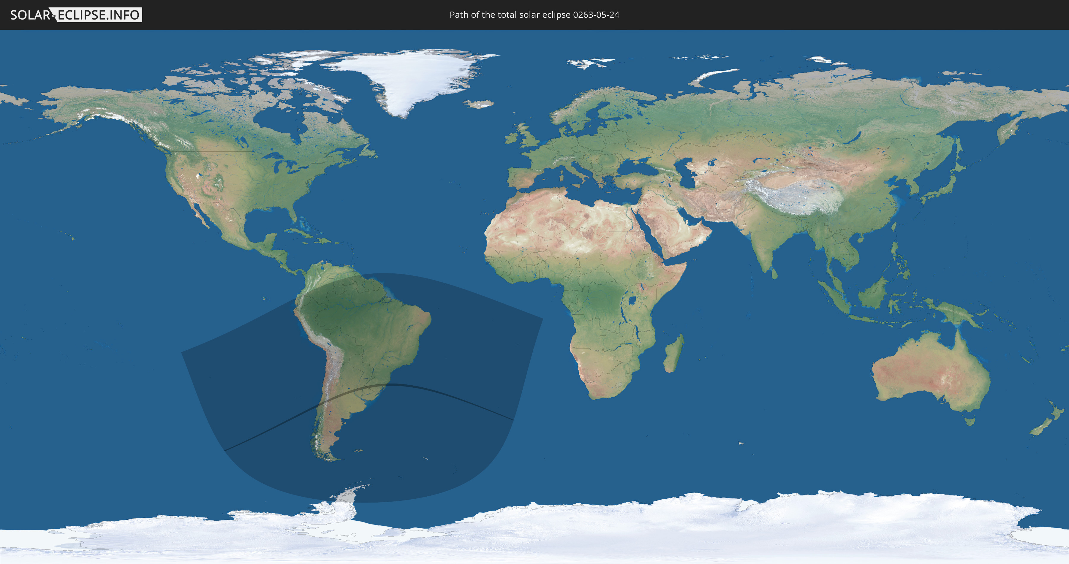
Die Sonnenfinsternis am 05/24/0263 kann man in 17 Ländern als partielle Sonnenfinsternis beobachten.
Der Finsternispfad verläuft durch 5 Länder. Nur in diesen Ländern ist sie als total Sonnenfinsternis zu sehen.
In den folgenden Ländern ist die Sonnenfinsternis total zu sehen
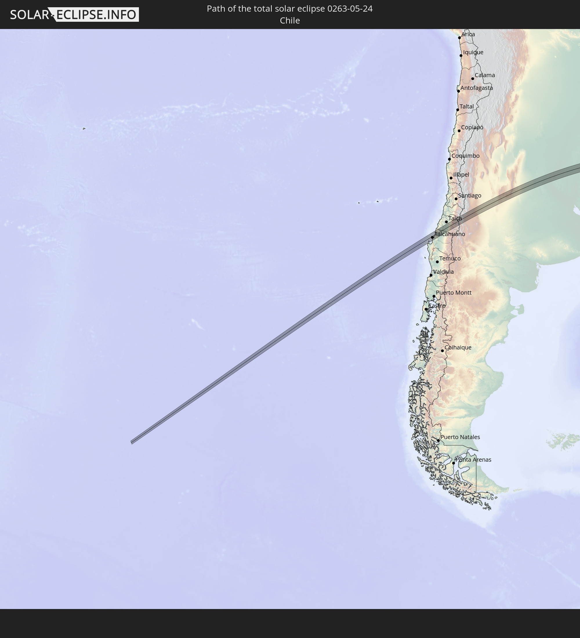 Chile
Chile
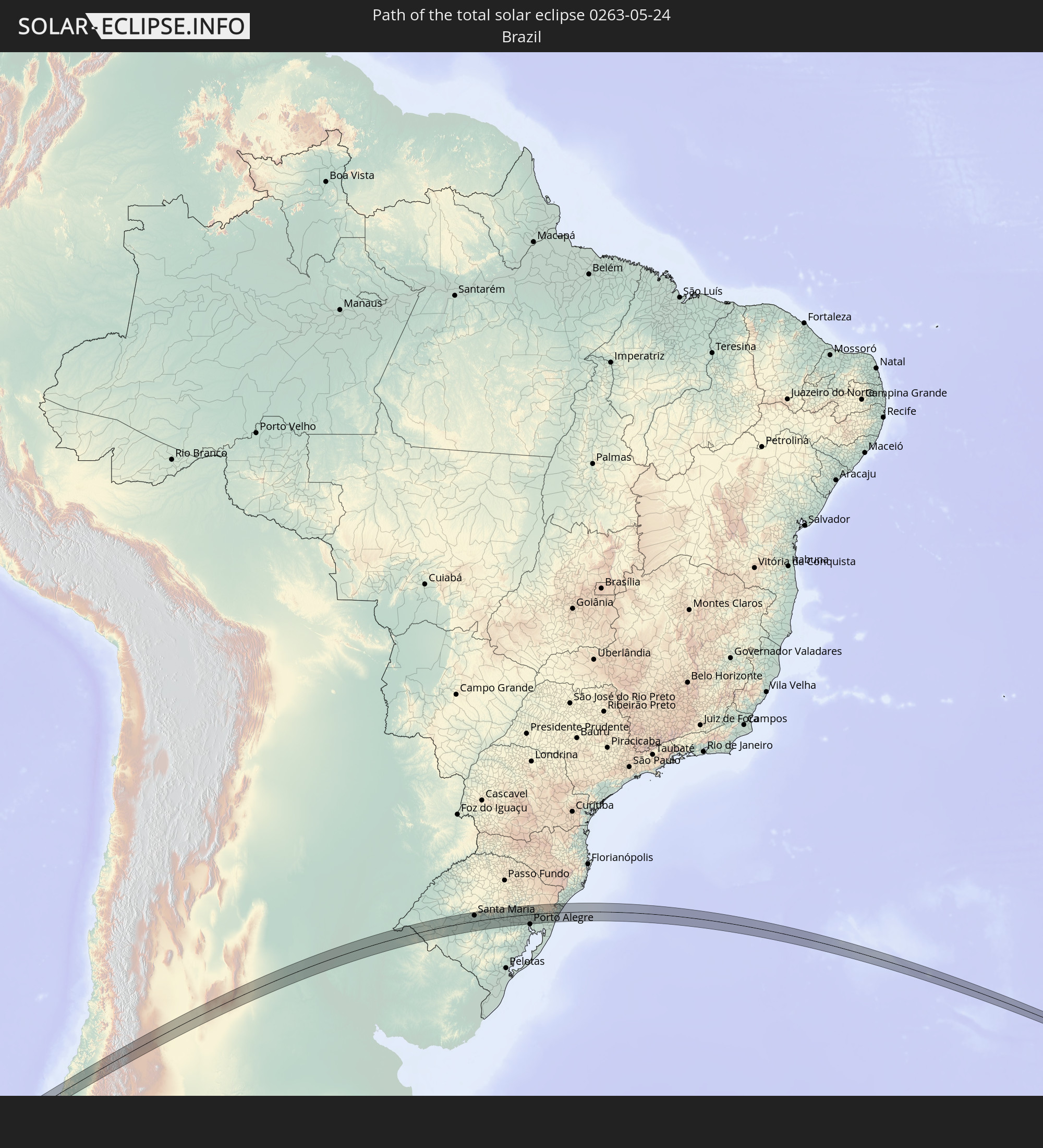 Brazil
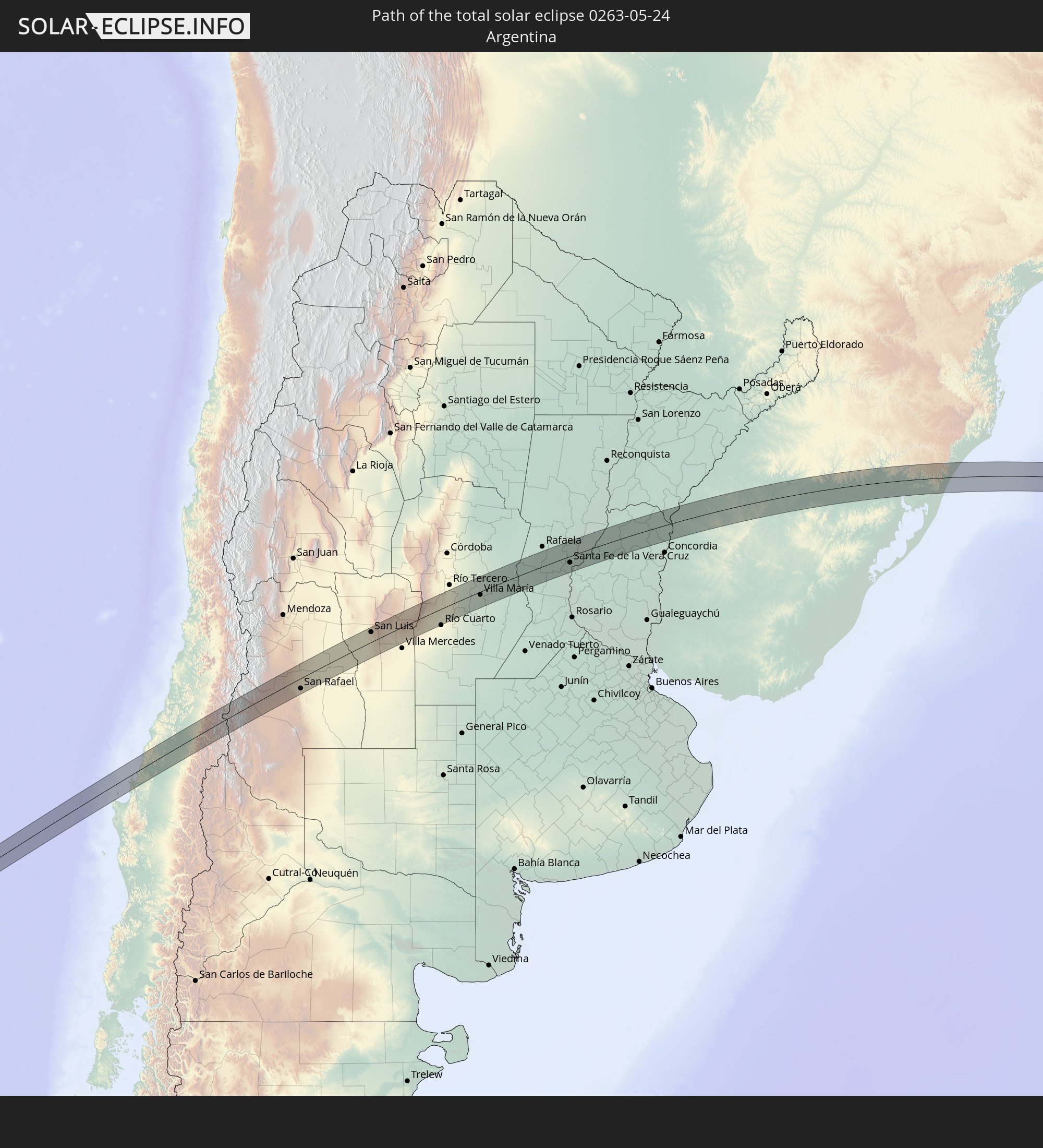 Argentina
 Uruguay
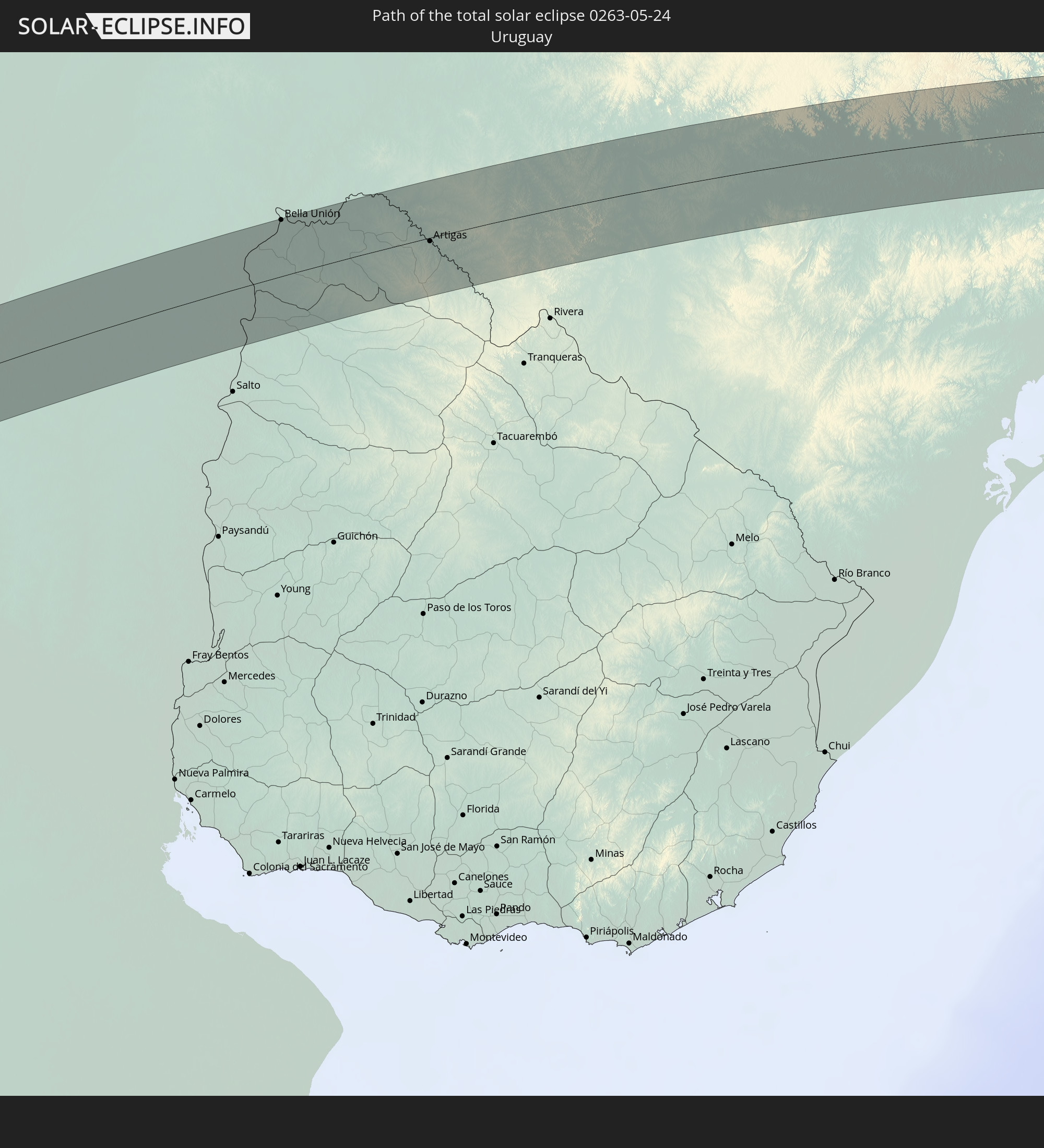
 Saint Helena, Ascension and Tristan da Cunha
In den folgenden Ländern ist die Sonnenfinsternis partiell zu sehen


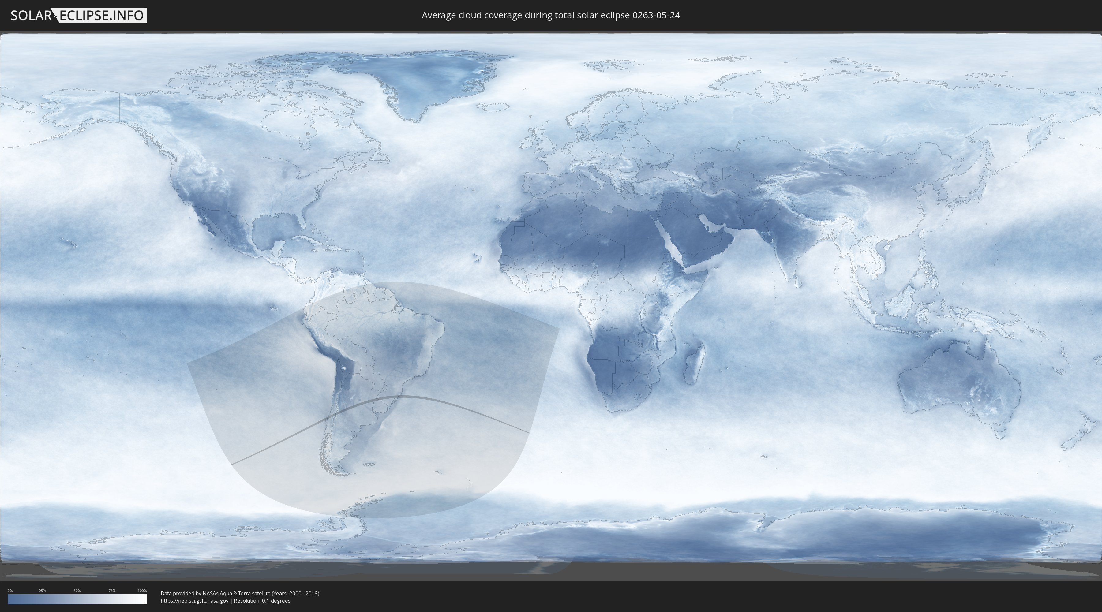
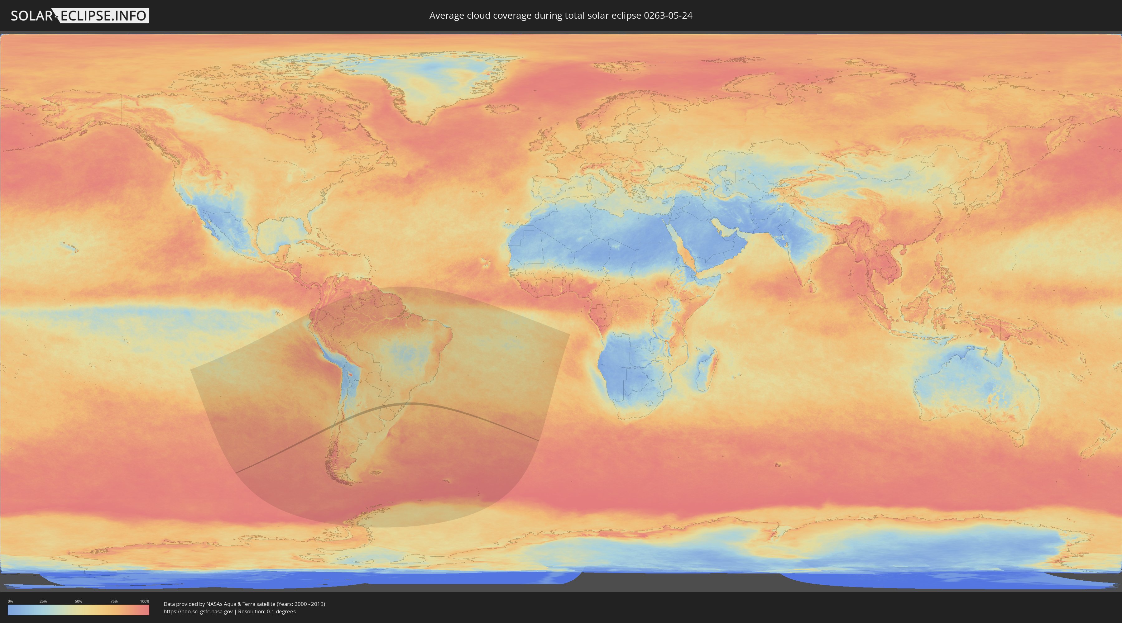
How will be the weather during the total solar eclipse on 05/24/0263?
Where is the best place to see the total solar eclipse of 05/24/0263?
The following maps show the average cloud coverage for the day of the total solar eclipse.
With the help of these maps, it is possible to find the place along the eclipse path, which has the best
chance of a cloudless sky.
Nevertheless, you should consider local circumstances and inform about the weather of your chosen
observation site.
The data is provided by NASAs satellites
AQUA and TERRA.
The cloud maps are averaged over a period of 19 years (2000 - 2019).
Detailed country maps
 Chile
Chile
 Brazil
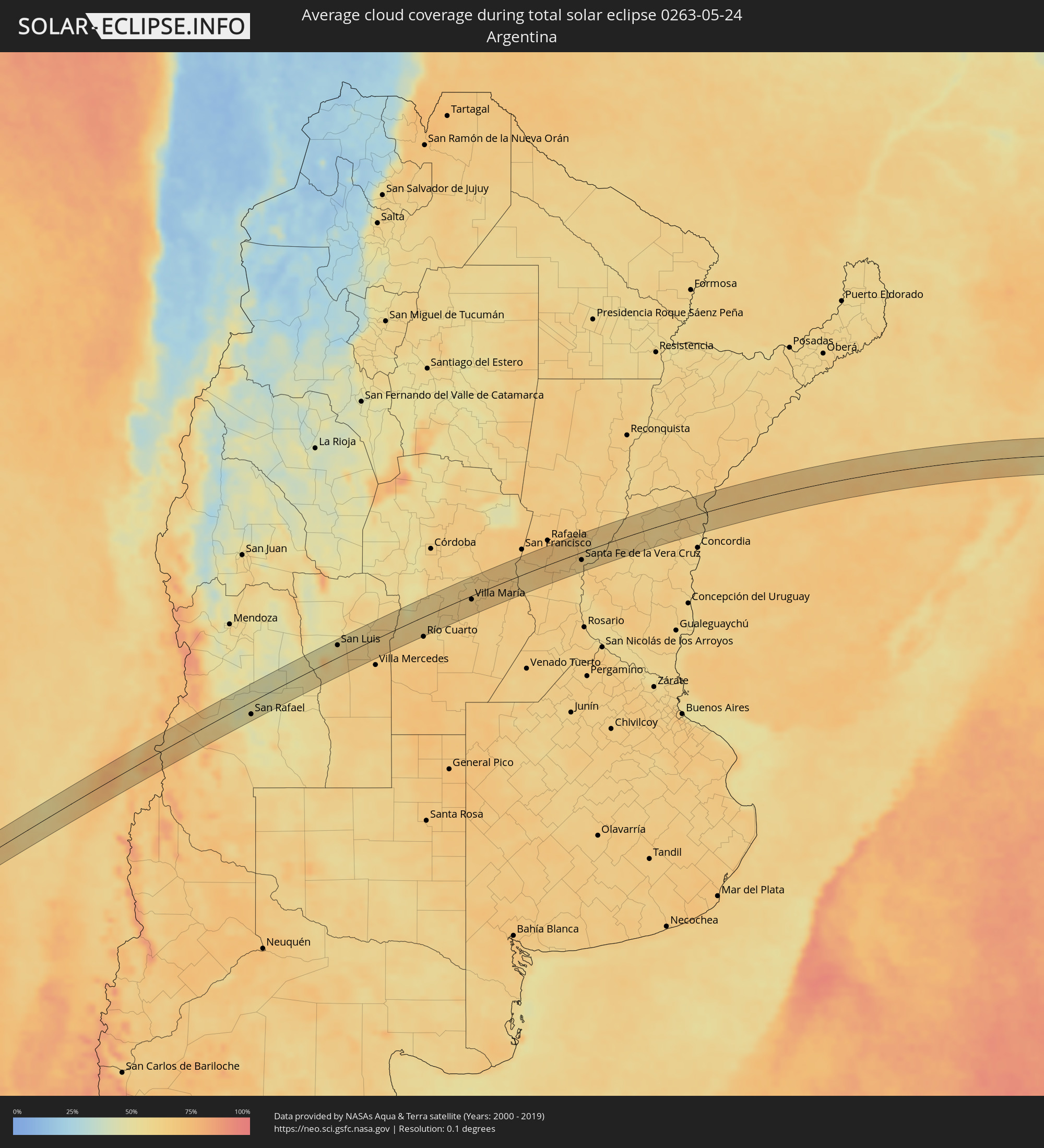 Argentina
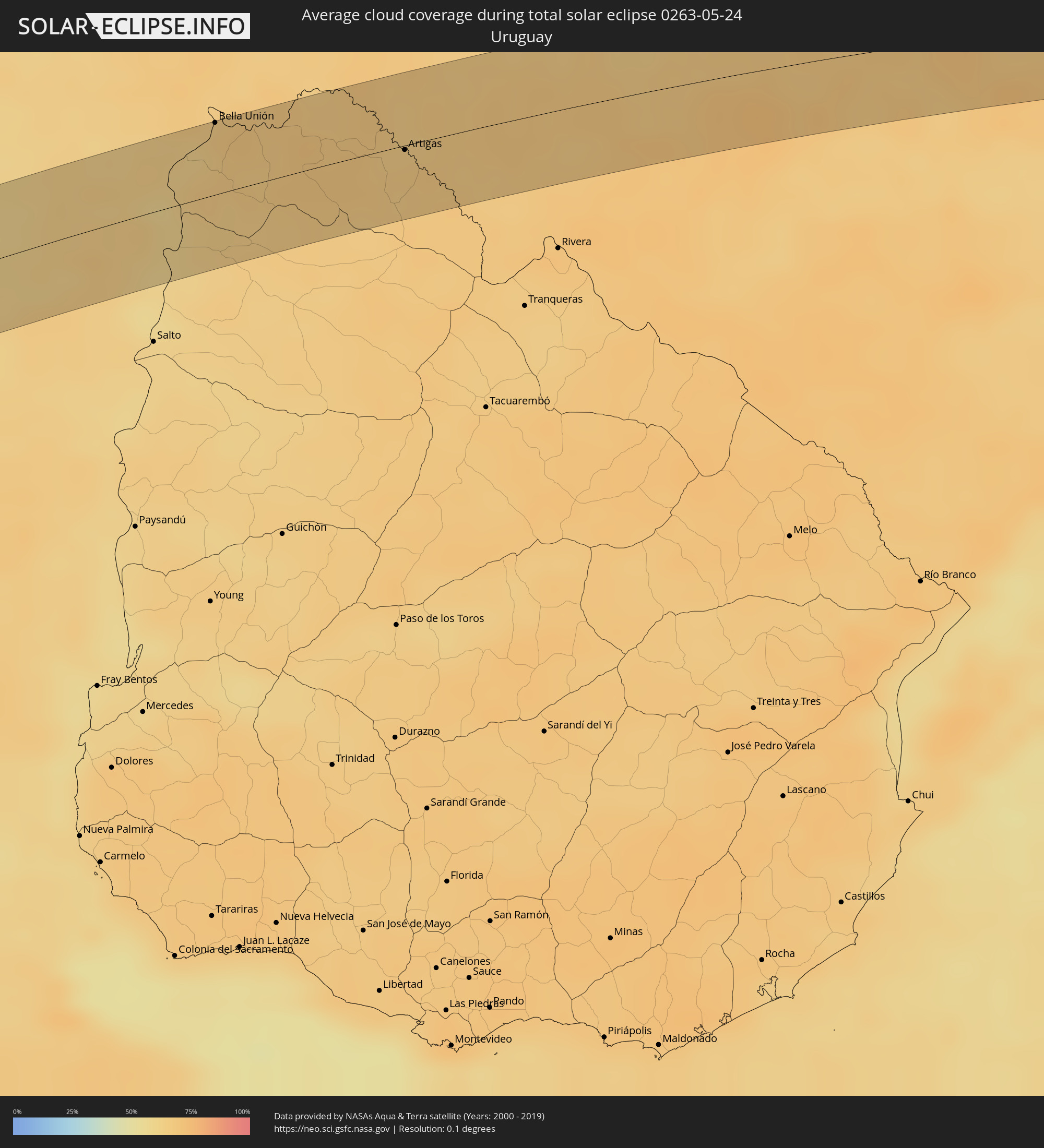 Uruguay
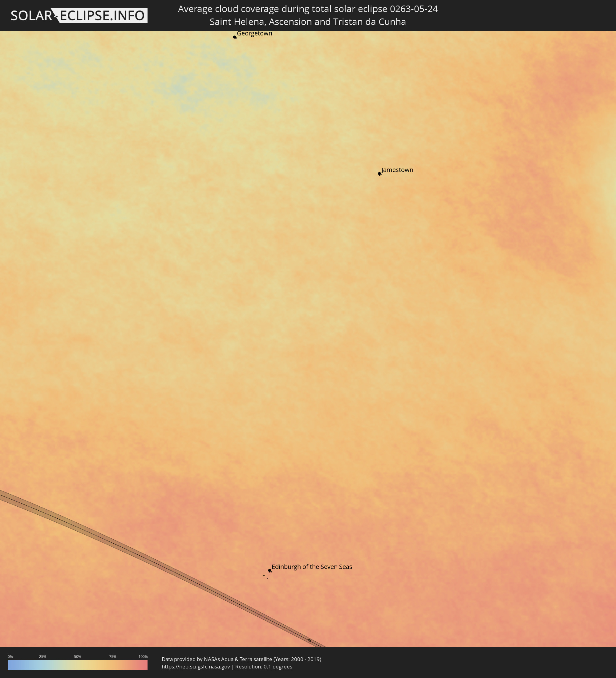 Saint Helena, Ascension and Tristan da Cunha
Cities inside the path of the eclipse
The following table shows all locations with a population of more than 5,000 inside the eclipse path. Cities which have more than 100,000 inhabitants are marked bold. A click at the locations opens a detailed map.
| City | Type | Eclipse duration | Local time of max. eclipse | Distance to central line | Ø Cloud coverage |
 Talcahuano, Biobío
|
total | - | 10:27:08 UTC-04:42 | 12 km | 59% |
|
Concepción, Biobío
|
total | - | 10:27:18 UTC-04:42 | 25 km | 61% |
|
Penco, Biobío
|
total | - | 10:27:23 UTC-04:42 | 19 km | 59% |
|
Tomé, Biobío
|
total | - | 10:27:25 UTC-04:42 | 9 km | 57% |
|
Cauquenes, Maule
|
total | - | 10:28:31 UTC-04:42 | 24 km | 65% |
|
Parral, Maule
|
total | - | 10:29:34 UTC-04:42 | 16 km | 74% |
|
Longaví, Maule
|
total | - | 10:29:49 UTC-04:42 | 5 km | 75% |
|
Linares, Maule
|
total | - | 10:29:59 UTC-04:42 | 2 km | 78% |
|
San Clemente, Maule
|
total | - | 10:30:08 UTC-04:42 | 27 km | 75% |
 San Rafael, Mendoza Province
|
total | - | 11:02:47 UTC-04:16 | 23 km | 54% |
|
San Luis, San Luis Province
|
total | - | 11:07:22 UTC-04:16 | 23 km | 57% |
|
La Punta, San Luis Province
|
total | - | 11:07:25 UTC-04:16 | 34 km | 57% |
|
La Toma, San Luis Province
|
total | - | 11:09:05 UTC-04:16 | 19 km | 61% |
|
Berrotarán, Cordoba Province
|
total | - | 11:12:09 UTC-04:16 | 31 km | 59% |
|
Tancacha, Cordoba Province
|
total | - | 11:13:12 UTC-04:16 | 37 km | 62% |
|
General Cabrera, Cordoba Province
|
total | - | 11:13:24 UTC-04:16 | 26 km | 61% |
|
Hernando, Cordoba Province
|
total | - | 11:13:48 UTC-04:16 | 9 km | 62% |
|
Villa Nueva, Cordoba Province
|
total | - | 11:15:01 UTC-04:16 | 10 km | 65% |
|
Villa María, Cordoba Province
|
total | - | 11:15:02 UTC-04:16 | 8 km | 65% |
|
Pozo del Molle, Cordoba Province
|
total | - | 11:15:55 UTC-04:16 | 20 km | 65% |
|
Las Varillas, Cordoba Province
|
total | - | 11:16:27 UTC-04:16 | 28 km | 67% |
|
San Jorge, Santa Fe Province
|
total | - | 11:18:40 UTC-04:16 | 5 km | 64% |
|
Sastre, Santa Fe Province
|
total | - | 11:18:46 UTC-04:16 | 8 km | 65% |
|
San Carlos Centro, Santa Fe Province
|
total | - | 11:20:42 UTC-04:16 | 13 km | 64% |
|
Esperanza, Santa Fe Province
|
total | - | 11:21:11 UTC-04:16 | 11 km | 68% |
|
Santo Tomé, Santa Fe Province
|
total | - | 11:21:34 UTC-04:16 | 17 km | 61% |
|
Recreo, Santa Fe Province
|
total | - | 11:21:42 UTC-04:16 | 0 km | 63% |
|
Santa Fe de la Vera Cruz, Santa Fe Province
|
total | - | 11:21:45 UTC-04:16 | 16 km | 64% |
|
Laguna Paiva, Santa Fe Province
|
total | - | 11:21:57 UTC-04:16 | 17 km | 65% |
|
Paraná, Entre Ríos Province
|
total | - | 11:22:11 UTC-04:16 | 32 km | 66% |
|
Villa Hernandarias, Entre Ríos Province
|
total | - | 11:23:45 UTC-04:16 | 3 km | 63% |
|
Santa Elena, Entre Ríos Province
|
total | - | 11:24:22 UTC-04:16 | 27 km | 64% |
|
Bovril, Entre Ríos Province
|
total | - | 11:25:10 UTC-04:16 | 25 km | 62% |
|
Federal, Entre Ríos Province
|
total | - | 11:27:04 UTC-04:16 | 3 km | 62% |
|
Chajarí, Entre Ríos Province
|
total | - | 11:29:18 UTC-04:16 | 3 km | 62% |
|
Mocoretá, Corrientes Province
|
total | - | 11:29:24 UTC-04:16 | 11 km | 61% |
|
Federación, Entre Ríos Province
|
total | - | 11:29:26 UTC-04:16 | 33 km | 59% |
 Bella Unión, Artigas
|
total | - | 12:02:29 UTC-03:44 | 40 km | 63% |
|
Artigas, Artigas
|
total | - | 12:05:32 UTC-03:44 | 3 km | 66% |
 Quaraí, Rio Grande do Sul
|
total | - | 12:43:58 UTC-03:06 | 2 km | 66% |
|
Rosário do Sul, Rio Grande do Sul
|
total | - | 12:48:15 UTC-03:06 | 19 km | 69% |
|
Cacequi, Rio Grande do Sul
|
total | - | 12:48:40 UTC-03:06 | 20 km | 66% |
|
São Gabriel, Rio Grande do Sul
|
total | - | 12:49:51 UTC-03:06 | 38 km | 70% |
|
São Pedro do Sul, Rio Grande do Sul
|
total | - | 12:50:36 UTC-03:06 | 38 km | 66% |
|
Santa Maria, Rio Grande do Sul
|
total | - | 12:51:36 UTC-03:06 | 25 km | 67% |
|
São Sepé, Rio Grande do Sul
|
total | - | 12:52:01 UTC-03:06 | 31 km | 64% |
|
Cachoeira do Sul, Rio Grande do Sul
|
total | - | 12:53:56 UTC-03:06 | 27 km | 72% |
|
Candelária, Rio Grande do Sul
|
total | - | 12:54:25 UTC-03:06 | 12 km | 64% |
|
Santa Cruz do Sul, Rio Grande do Sul
|
total | - | 12:55:24 UTC-03:06 | 2 km | 67% |
|
Rio Pardo, Rio Grande do Sul
|
total | - | 12:55:23 UTC-03:06 | 28 km | 70% |
|
Venâncio Aires, Rio Grande do Sul
|
total | - | 12:56:06 UTC-03:06 | 12 km | 67% |
|
Lajeado, Rio Grande do Sul
|
total | - | 12:56:49 UTC-03:06 | 25 km | 62% |
|
Arroio do Meio, Rio Grande do Sul
|
total | - | 12:56:54 UTC-03:06 | 32 km | 62% |
|
Taquari, Rio Grande do Sul
|
total | - | 12:56:54 UTC-03:06 | 13 km | 67% |
|
Teutônia, Rio Grande do Sul
|
total | - | 12:57:15 UTC-03:06 | 26 km | 62% |
|
São Jerônimo, Rio Grande do Sul
|
total | - | 12:57:12 UTC-03:06 | 32 km | 69% |
|
Triunfo, Rio Grande do Sul
|
total | - | 12:57:13 UTC-03:06 | 30 km | 66% |
|
Charqueadas, Rio Grande do Sul
|
total | - | 12:57:28 UTC-03:06 | 32 km | 70% |
|
Carlos Barbosa, Rio Grande do Sul
|
total | - | 12:58:10 UTC-03:06 | 39 km | 60% |
|
Montenegro, Rio Grande do Sul
|
total | - | 12:58:04 UTC-03:06 | 4 km | 66% |
|
São Sebastião do Caí, Rio Grande do Sul
|
total | - | 12:58:22 UTC-03:06 | 6 km | 66% |
|
Portão, Rio Grande do Sul
|
total | - | 12:58:40 UTC-03:06 | 8 km | 68% |
|
Canoas, Rio Grande do Sul
|
total | - | 12:58:42 UTC-03:06 | 32 km | 69% |
|
Esteio, Rio Grande do Sul
|
total | - | 12:58:44 UTC-03:06 | 26 km | 69% |
|
Estância Velha, Rio Grande do Sul
|
total | - | 12:58:53 UTC-03:06 | 2 km | 67% |
|
Ivoti, Rio Grande do Sul
|
total | - | 12:58:57 UTC-03:06 | 4 km | 67% |
|
Sapucaia, Rio Grande do Sul
|
total | - | 12:58:50 UTC-03:06 | 23 km | 71% |
|
São Leopoldo, Rio Grande do Sul
|
total | - | 12:58:53 UTC-03:06 | 15 km | 71% |
|
Novo Hamburgo, Rio Grande do Sul
|
total | - | 12:58:59 UTC-03:06 | 6 km | 70% |
|
Nova Petrópolis, Rio Grande do Sul
|
total | - | 12:59:12 UTC-03:06 | 28 km | 62% |
|
Cachoeirinha, Rio Grande do Sul
|
total | - | 12:58:55 UTC-03:06 | 36 km | 69% |
|
Sapiranga, Rio Grande do Sul
|
total | - | 12:59:20 UTC-03:06 | 2 km | 67% |
|
Gravataí, Rio Grande do Sul
|
total | - | 12:59:12 UTC-03:06 | 36 km | 71% |
|
Parobé, Rio Grande do Sul
|
total | - | 12:59:49 UTC-03:06 | 3 km | 66% |
|
Canela, Rio Grande do Sul
|
total | - | 13:00:02 UTC-03:06 | 28 km | 60% |
|
Igrejinha, Rio Grande do Sul
|
total | - | 12:59:58 UTC-03:06 | 3 km | 66% |
|
Taquara, Rio Grande do Sul
|
total | - | 12:59:57 UTC-03:06 | 5 km | 67% |
|
Três Coroas, Rio Grande do Sul
|
total | - | 13:00:02 UTC-03:06 | 9 km | 64% |
|
São Francisco de Paula, Rio Grande do Sul
|
total | - | 13:00:37 UTC-03:06 | 16 km | 62% |
|
Rolante, Rio Grande do Sul
|
total | - | 13:00:31 UTC-03:06 | 7 km | 67% |
|
Osório, Rio Grande do Sul
|
total | - | 13:01:12 UTC-03:06 | 35 km | 59% |
|
Capão da Canoa, Rio Grande do Sul
|
total | - | 13:01:59 UTC-03:06 | 20 km | 56% |
|
Torres, Rio Grande do Sul
|
total | - | 13:03:01 UTC-03:06 | 24 km | 52% |