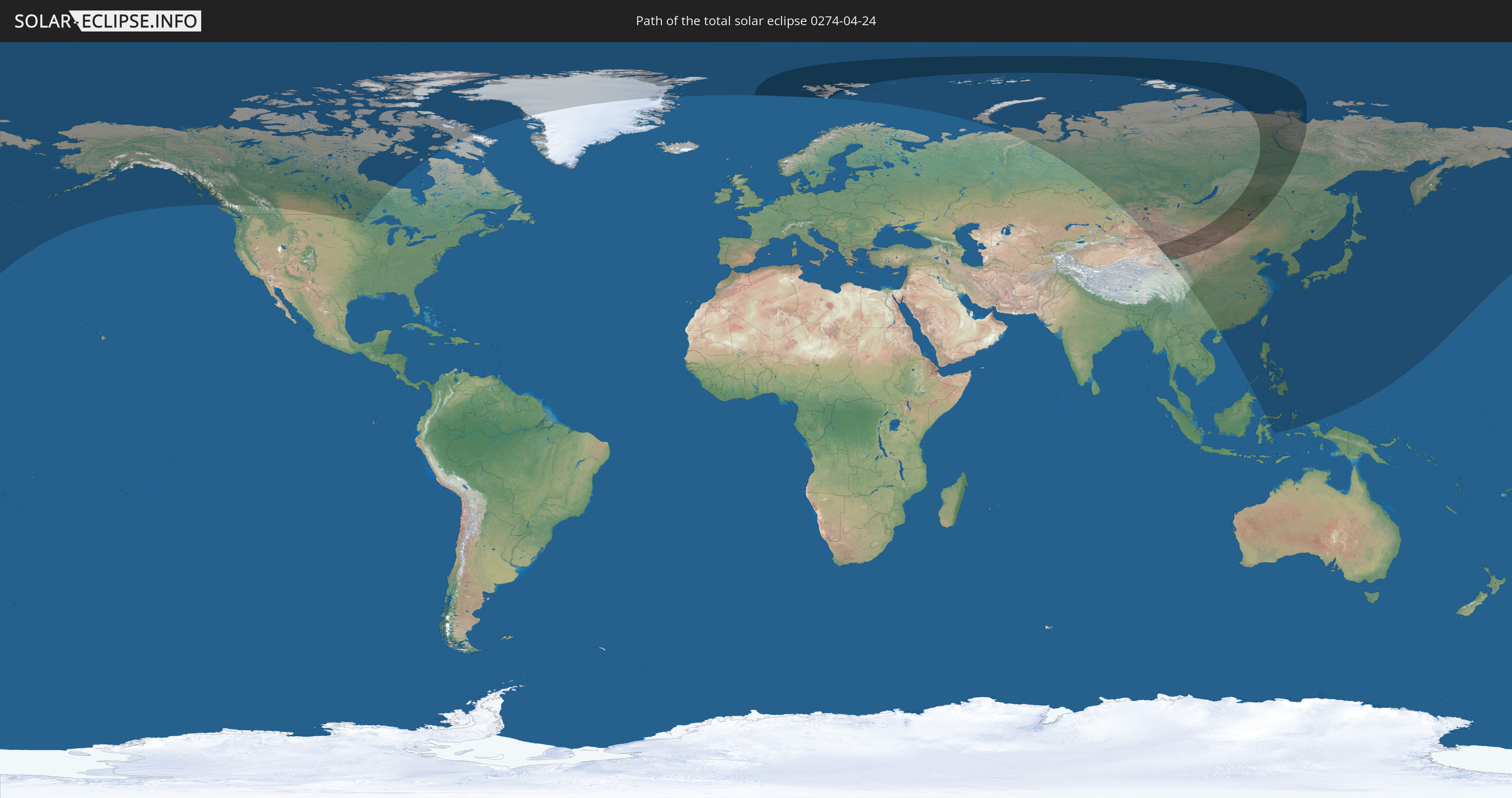
Total solar eclipse of 04/24/0274
| Day of week: | Friday |
| Maximum duration of eclipse: | 03m14s |
| Maximum width of eclipse path: | 463 km |
| Saros cycle: | 91 |
| Coverage: | 100% |
| Magnitude: | 1.0564 |
| Gamma: | 0.9159 |
Wo kann man die Sonnenfinsternis vom 04/24/0274 sehen?
Die Sonnenfinsternis am 04/24/0274 kann man in 20 Ländern als partielle Sonnenfinsternis beobachten.
Der Finsternispfad verläuft durch 4 Länder. Nur in diesen Ländern ist sie als total Sonnenfinsternis zu sehen.
In den folgenden Ländern ist die Sonnenfinsternis total zu sehen
 Russia
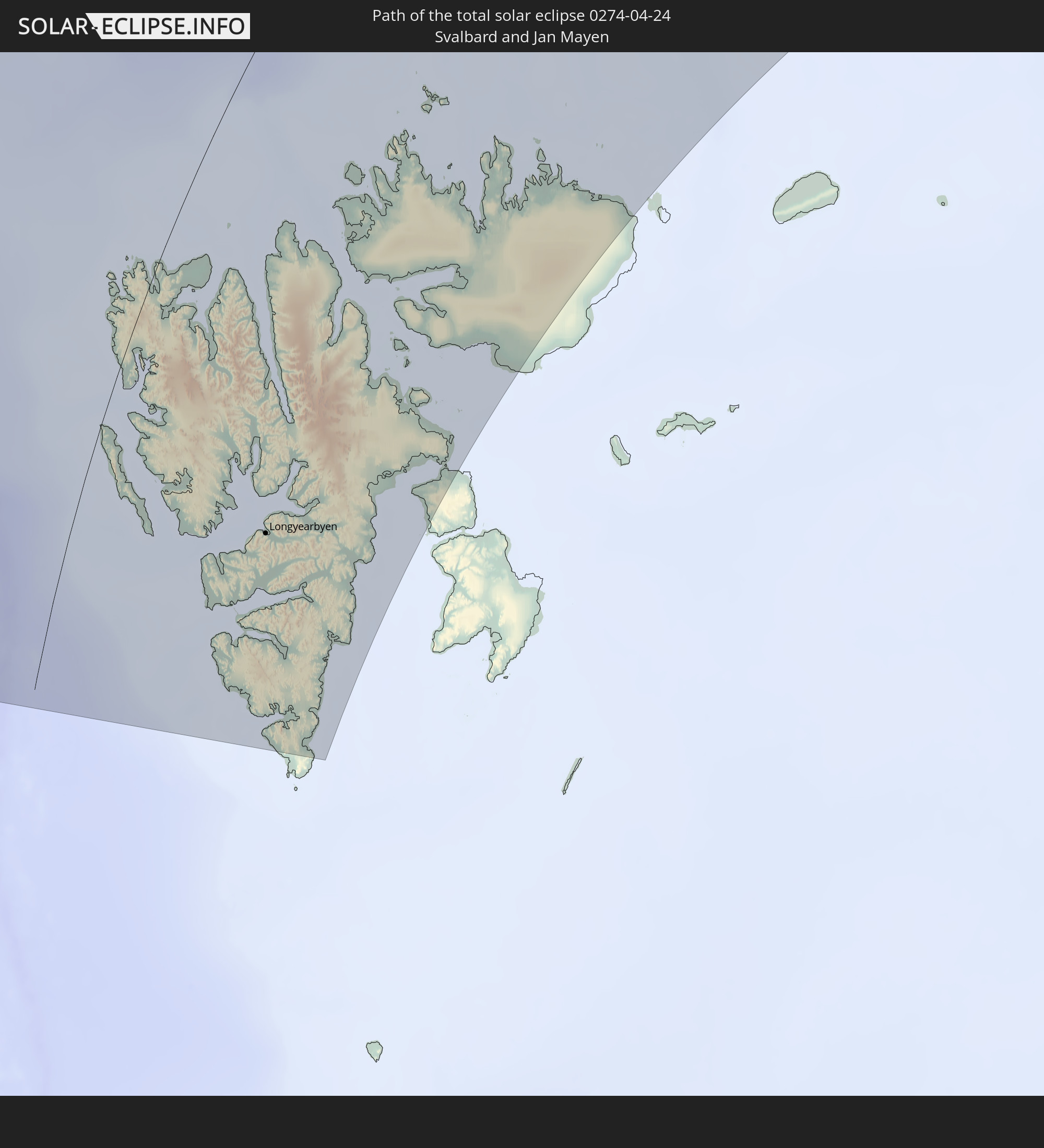 Svalbard and Jan Mayen
 China
China
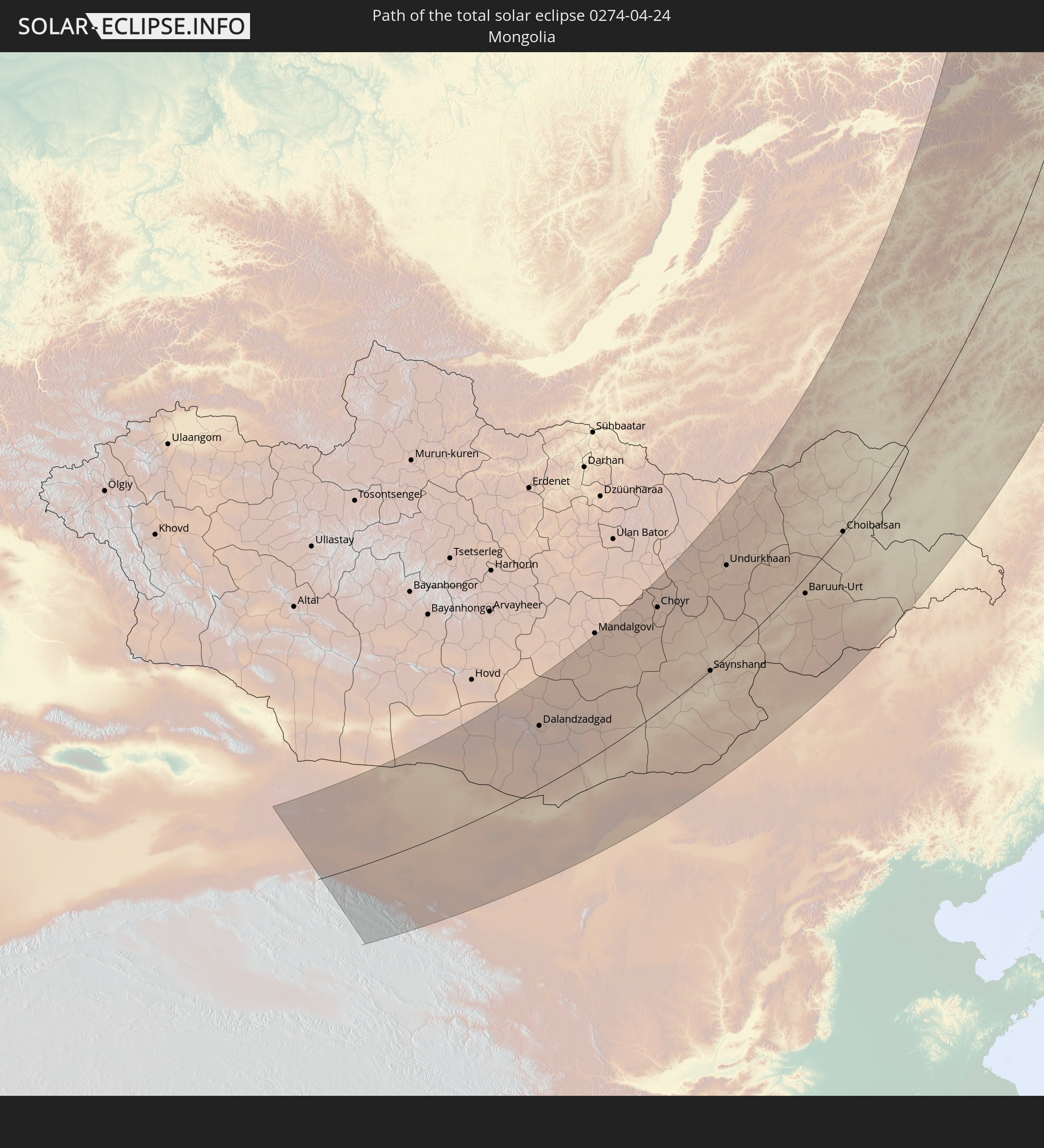 Mongolia
In den folgenden Ländern ist die Sonnenfinsternis partiell zu sehen


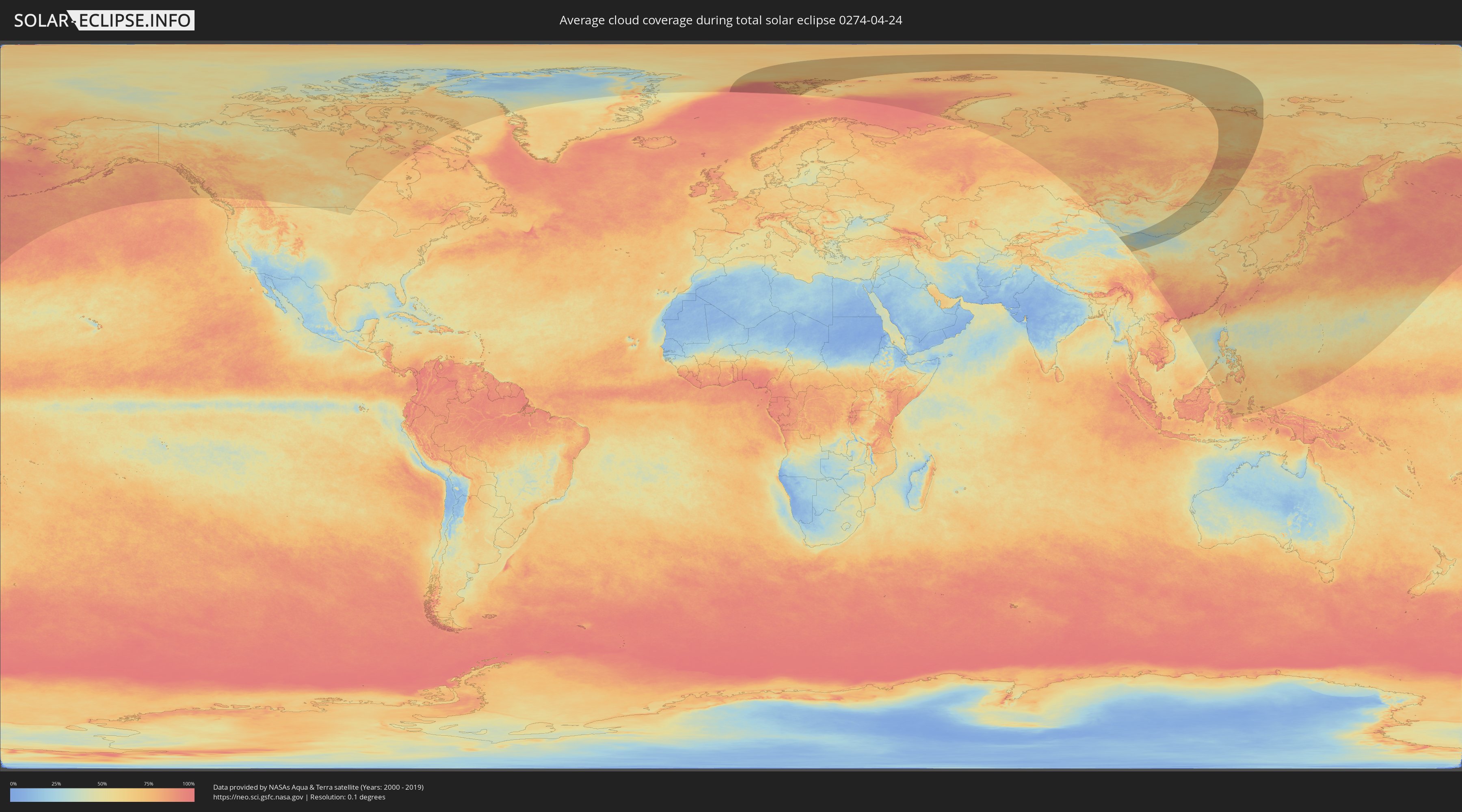
How will be the weather during the total solar eclipse on 04/24/0274?
Where is the best place to see the total solar eclipse of 04/24/0274?
The following maps show the average cloud coverage for the day of the total solar eclipse.
With the help of these maps, it is possible to find the place along the eclipse path, which has the best
chance of a cloudless sky.
Nevertheless, you should consider local circumstances and inform about the weather of your chosen
observation site.
The data is provided by NASAs satellites
AQUA and TERRA.
The cloud maps are averaged over a period of 19 years (2000 - 2019).

Detailed country maps
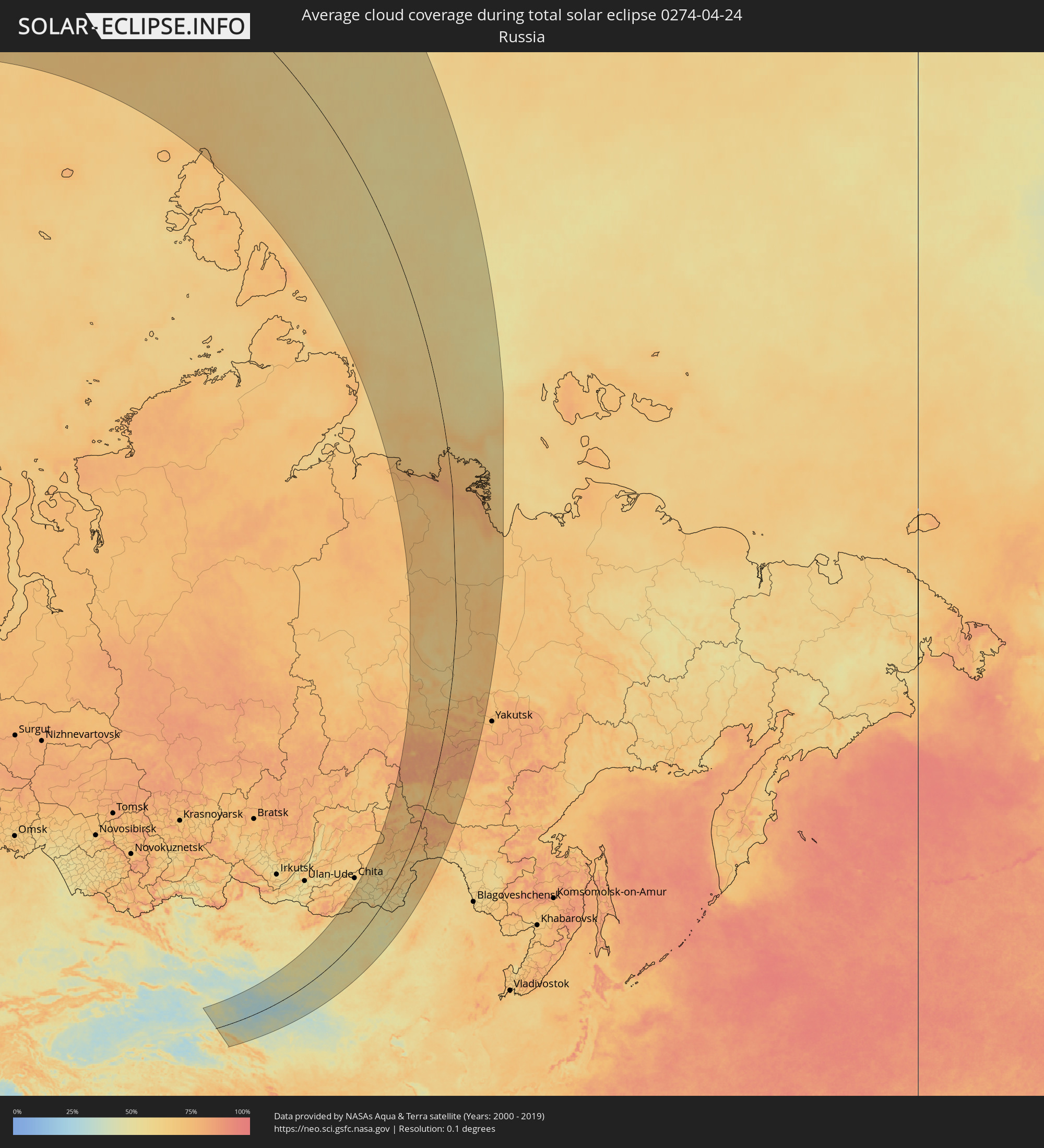 Russia
 Svalbard and Jan Mayen
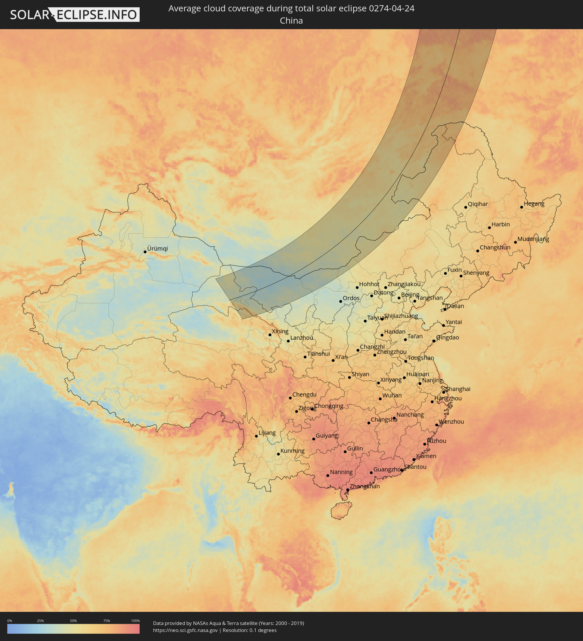 China
China
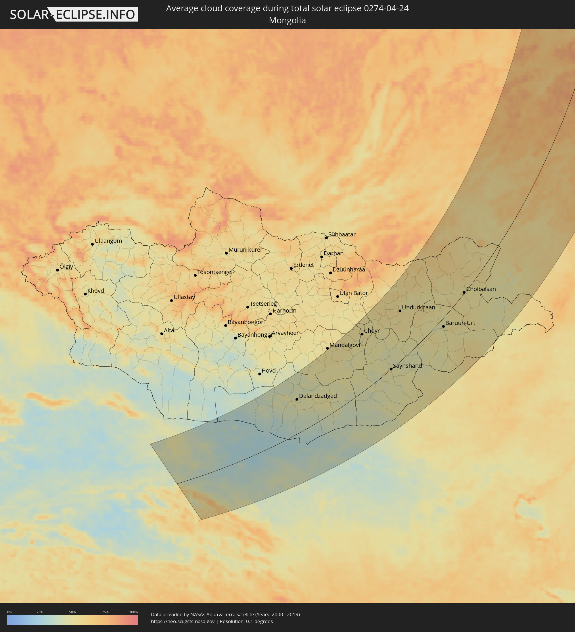 Mongolia
Cities inside the path of the eclipse
The following table shows all locations with a population of more than 5,000 inside the eclipse path. Cities which have more than 100,000 inhabitants are marked bold. A click at the locations opens a detailed map.
| City | Type | Eclipse duration | Local time of max. eclipse | Distance to central line | Ø Cloud coverage |
 Longyearbyen, Svalbard
|
total | - | 01:05:43 UTC+01:00 | 132 km | 72% |
 Laojunmiao, Gansu
|
total | - | 06:45:27 UTC+08:00 | 9 km | 40% |
|
Jiayuguan, Gansu
|
total | - | 06:45:14 UTC+08:00 | 25 km | 42% |
|
Jiuquan, Gansu
|
total | - | 06:45:03 UTC+08:00 | 39 km | 42% |
|
Zhangye, Gansu
|
total | - | 06:43:15 UTC+08:00 | 179 km | 45% |
 Dalandzadgad, Ömnögovĭ
|
total | - | 05:57:08 UTC+07:07 | 147 km | 45% |
|
Choyr, Govĭ-Sumber
|
total | - | 06:01:18 UTC+07:07 | 213 km | 51% |
|
Saynshand, East Gobi Aymag
|
total | - | 05:58:39 UTC+07:07 | 1 km | 48% |
|
Undurkhaan, Hentiy
|
total | - | 06:02:50 UTC+07:07 | 166 km | 55% |
|
Erenhot, Inner Mongolia
|
total | - | 06:48:54 UTC+08:00 | 202 km | 51% |
|
Baruun-Urt, Sühbaatar
|
total | - | 06:01:41 UTC+07:07 | 28 km | 48% |
 Dul’durga, Transbaikal Territory
|
total | - | 07:40:15 UTC+08:38 | 223 km | 56% |
|
Darasun, Transbaikal Territory
|
total | - | 07:42:03 UTC+08:38 | 256 km | 55% |
|
Karymskoye, Transbaikal Territory
|
total | - | 07:42:00 UTC+08:38 | 231 km | 54% |
|
Aginskoye, Transbaikal Territory
|
total | - | 07:41:05 UTC+08:38 | 191 km | 55% |
|
Choibalsan, East Aimak
|
total | - | 06:04:11 UTC+07:07 | 1 km | 52% |
|
Mogoytuy, Transbaikal Territory
|
total | - | 07:41:26 UTC+08:38 | 178 km | 52% |
|
Vershino-Darasunskiy, Transbaikal Territory
|
total | - | 07:43:28 UTC+08:38 | 198 km | 64% |
|
Olovyannaya, Transbaikal Territory
|
total | - | 07:40:53 UTC+08:38 | 120 km | 53% |
|
Pervomayskiy, Transbaikal Territory
|
total | - | 07:42:12 UTC+08:38 | 156 km | 57% |
|
Shilka, Transbaikal Territory
|
total | - | 07:42:34 UTC+08:38 | 141 km | 55% |
|
Borzya, Transbaikal Territory
|
total | - | 07:39:56 UTC+08:38 | 30 km | 55% |
|
Nerchinsk, Transbaikal Territory
|
total | - | 07:42:52 UTC+08:38 | 115 km | 58% |
|
Baley, Transbaikal Territory
|
total | - | 07:42:08 UTC+08:38 | 91 km | 61% |
|
Chernyshevsk, Transbaikal Territory
|
total | - | 07:43:55 UTC+08:38 | 116 km | 57% |
|
Zabaykal’sk, Transbaikal Territory
|
total | - | 07:38:41 UTC+08:38 | 62 km | 56% |
|
Manzhouli, Inner Mongolia
|
total | - | 06:59:38 UTC+08:00 | 72 km | 55% |
|
Kokuy, Transbaikal Territory
|
total | - | 07:43:24 UTC+08:38 | 67 km | 61% |
|
Jalai Nur, Inner Mongolia
|
total | - | 06:59:23 UTC+08:00 | 97 km | 57% |
|
Sretensk, Transbaikal Territory
|
total | - | 07:43:29 UTC+08:38 | 60 km | 59% |
|
Krasnokamensk, Transbaikal Territory
|
total | - | 07:39:34 UTC+08:38 | 78 km | 58% |
|
Priargunsk, Transbaikal Territory
|
total | - | 07:40:13 UTC+08:38 | 127 km | 55% |
|
Hailar, Inner Mongolia
|
total | - | 06:59:11 UTC+08:00 | 233 km | 60% |
|
Mogocha, Transbaikal Territory
|
total | - | 07:46:33 UTC+08:38 | 6 km | 67% |
|
Verkhnevilyuysk, Sakha
|
total | - | 08:04:45 UTC+08:38 | 220 km | 75% |
|
Olyokminsk, Sakha
|
total | - | 07:59:04 UTC+08:38 | 176 km | 75% |
|
Vilyuysk, Sakha
|
total | - | 08:05:35 UTC+08:38 | 157 km | 68% |
|
Yerofey Pavlovich, Amur
|
total | - | 07:47:24 UTC+08:38 | 116 km | 67% |
|
Skovorodino, Amur
|
total | - | 07:47:53 UTC+08:38 | 233 km | 64% |
|
Neryungri, Sakha
|
total | - | 07:53:06 UTC+08:38 | 164 km | 79% |
|
Tynda, Amur
|
total | - | 07:50:17 UTC+08:38 | 229 km | 76% |
|
Chul’man, Sakha
|
total | - | 07:53:31 UTC+08:38 | 173 km | 76% |
|
Aldan, Sakha
|
total | - | 07:56:57 UTC+08:38 | 142 km | 76% |
|
Nizhniy Kuranakh, Sakha
|
total | - | 07:57:23 UTC+08:38 | 143 km | 84% |
|
Tommot, Sakha
|
total | - | 07:57:51 UTC+08:38 | 181 km | 82% |
|
Berdigestyakh, Sakha
|
total | - | 08:03:49 UTC+08:38 | 121 km | 79% |
|
Tiksi, Sakha
|
total | - | 08:21:33 UTC+08:38 | 164 km | 76% |