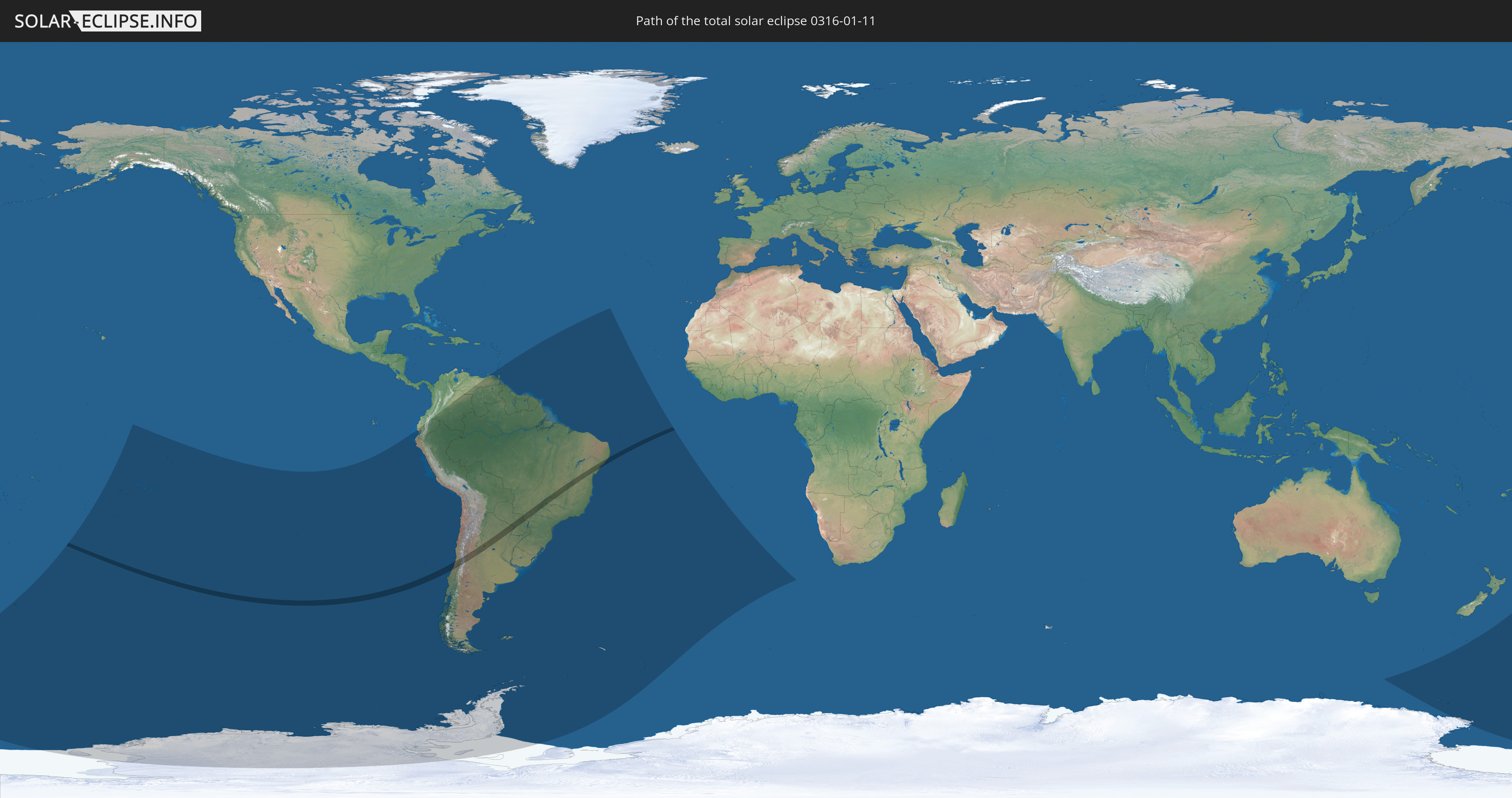
Total solar eclipse of 01/11/0316
| Day of week: | Tuesday |
| Maximum duration of eclipse: | 03m18s |
| Maximum width of eclipse path: | 142 km |
| Saros cycle: | 75 |
| Coverage: | 100% |
| Magnitude: | 1.0406 |
| Gamma: | -0.2935 |
Wo kann man die Sonnenfinsternis vom 01/11/0316 sehen?
Die Sonnenfinsternis am 01/11/0316 kann man in 24 Ländern als partielle Sonnenfinsternis beobachten.
Der Finsternispfad verläuft durch 4 Länder. Nur in diesen Ländern ist sie als total Sonnenfinsternis zu sehen.
In den folgenden Ländern ist die Sonnenfinsternis total zu sehen
 Chile
Chile
 Brazil
 Argentina
 Paraguay
In den folgenden Ländern ist die Sonnenfinsternis partiell zu sehen
 Antarctica
 New Zealand
 Kiribati
 Cook Islands
 French Polynesia
 Pitcairn Islands
 Chile
Chile
 Ecuador
 Colombia
 Peru
Peru
 Brazil
 Argentina
 Venezuela
 Bolivia
 Paraguay
 Trinidad and Tobago
 Falkland Islands
 Guyana
 Barbados
 Uruguay
 Suriname
 French Guiana
 South Georgia and the South Sandwich Islands
 Saint Helena, Ascension and Tristan da Cunha
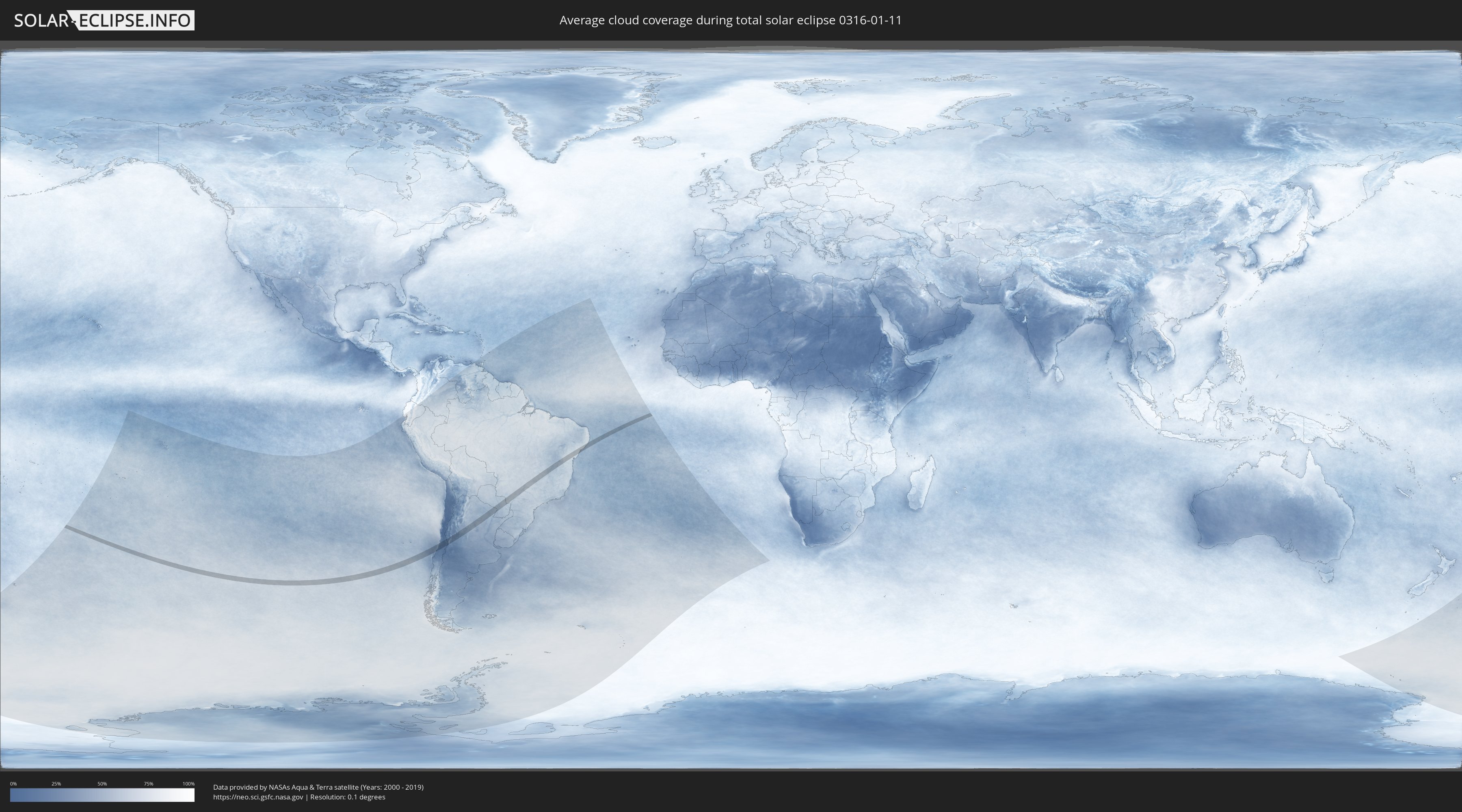
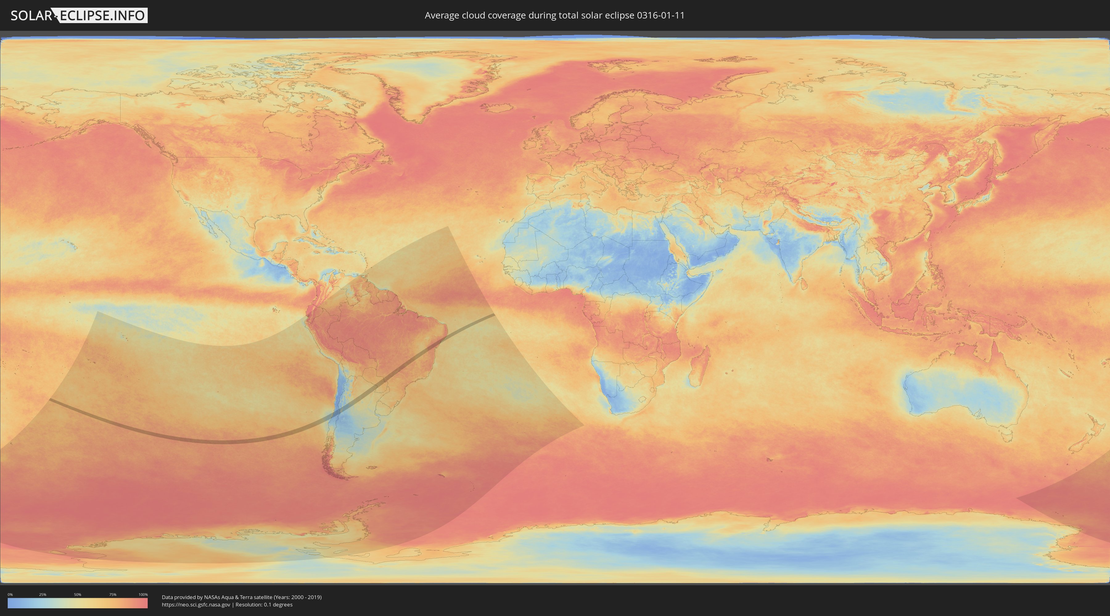
How will be the weather during the total solar eclipse on 01/11/0316?
Where is the best place to see the total solar eclipse of 01/11/0316?
The following maps show the average cloud coverage for the day of the total solar eclipse.
With the help of these maps, it is possible to find the place along the eclipse path, which has the best
chance of a cloudless sky.
Nevertheless, you should consider local circumstances and inform about the weather of your chosen
observation site.
The data is provided by NASAs satellites
AQUA and TERRA.
The cloud maps are averaged over a period of 19 years (2000 - 2019).
Detailed country maps
 Chile
Chile
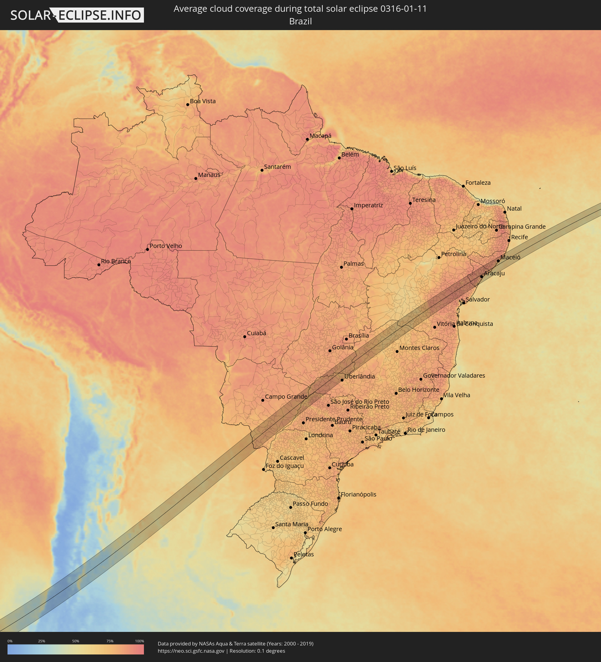 Brazil
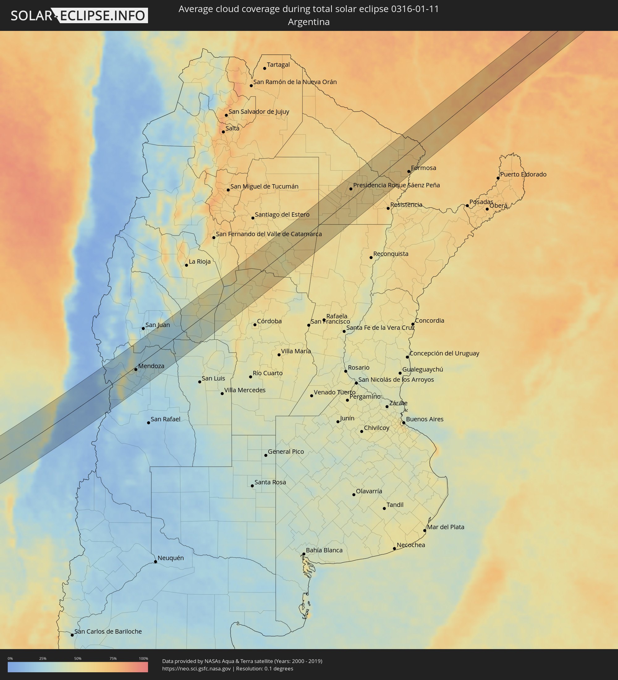 Argentina
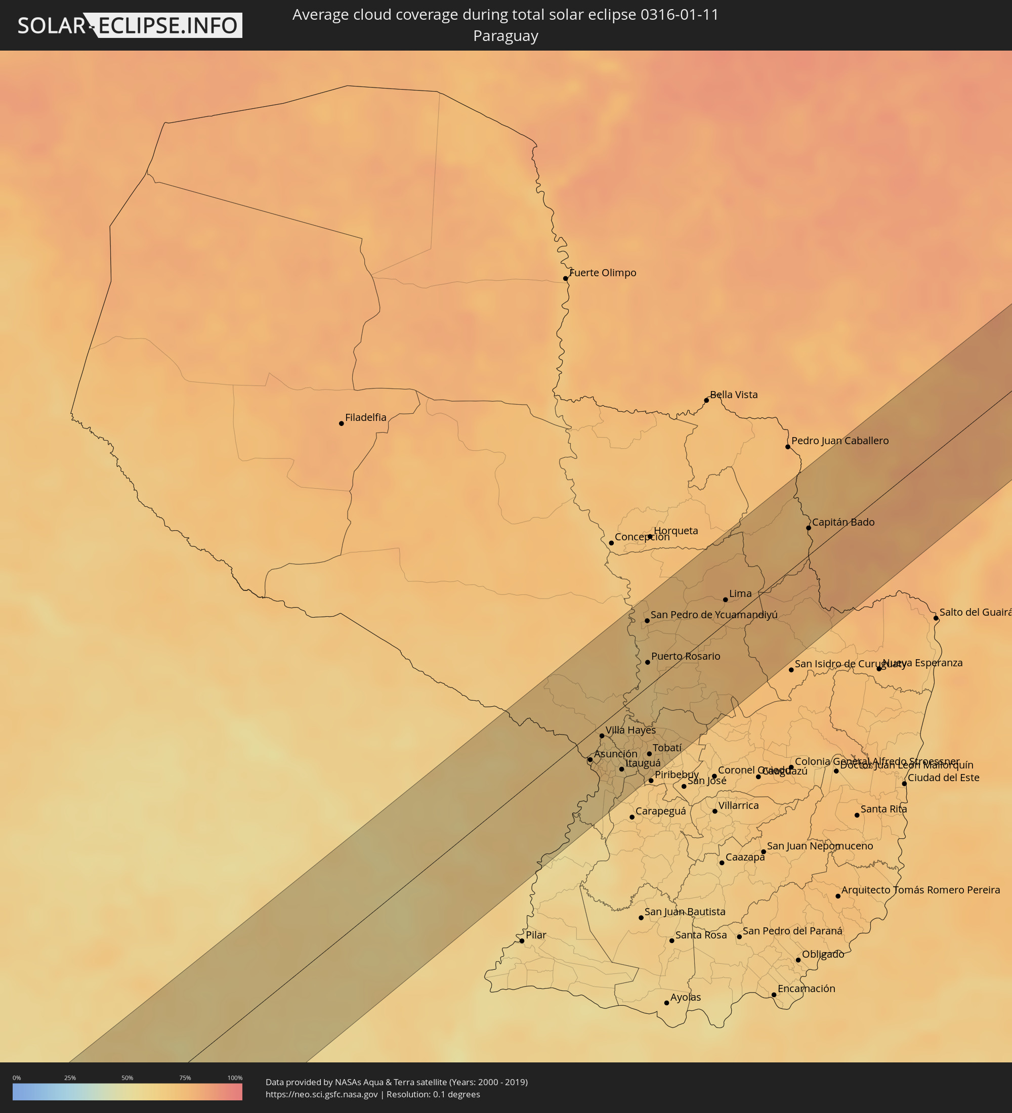 Paraguay
Cities inside the path of the eclipse
The following table shows all locations with a population of more than 5,000 inside the eclipse path. Cities which have more than 100,000 inhabitants are marked bold. A click at the locations opens a detailed map.
| City | Type | Eclipse duration | Local time of max. eclipse | Distance to central line | Ø Cloud coverage |
|
Constitución, Maule
|
total | - | 13:30:07 UTC-04:42 | 44 km | 21% |
|
Santa Cruz, O'Higgins
|
total | - | 13:33:01 UTC-04:42 | 33 km | 11% |
|
Rauco, Maule
|
total | - | 13:32:39 UTC-04:42 | 62 km | 11% |
|
Curicó, Maule
|
total | - | 13:32:41 UTC-04:42 | 71 km | 12% |
|
Melipilla, Santiago Metropolitan
|
total | - | 13:34:46 UTC-04:42 | 46 km | 14% |
|
Teno, Maule
|
total | - | 13:33:00 UTC-04:42 | 65 km | 12% |
|
San Vicente, O'Higgins
|
total | - | 13:33:49 UTC-04:42 | 29 km | 11% |
|
San Vicente de Tagua Tagua, O'Higgins
|
total | - | 13:33:49 UTC-04:42 | 30 km | 11% |
|
Chimbarongo, O'Higgins
|
total | - | 13:33:27 UTC-04:42 | 56 km | 13% |
|
El Monte, Santiago Metropolitan
|
total | - | 13:35:11 UTC-04:42 | 35 km | 11% |
|
Talagante, Santiago Metropolitan
|
total | - | 13:35:19 UTC-04:42 | 34 km | 11% |
|
Peñaflor, Santiago Metropolitan
|
total | - | 13:35:29 UTC-04:42 | 36 km | 11% |
|
Lampa, Santiago Metropolitan
|
total | - | 13:36:00 UTC-04:42 | 65 km | 8% |
|
Rengo, O'Higgins
|
total | - | 13:34:15 UTC-04:42 | 38 km | 11% |
|
Rancagua, O'Higgins
|
total | - | 13:34:49 UTC-04:42 | 22 km | 9% |
|
Buin, Santiago Metropolitan
|
total | - | 13:35:31 UTC-04:42 | 18 km | 9% |
|
Paine, Santiago Metropolitan
|
total | - | 13:35:24 UTC-04:42 | 11 km | 9% |
|
Graneros, O'Higgins
|
total | - | 13:35:00 UTC-04:42 | 14 km | 9% |
|
Lo Prado, Santiago Metropolitan
|
total | - | 13:36:00 UTC-04:42 | 43 km | 9% |
|
San Bernardo, Santiago Metropolitan
|
total | - | 13:35:49 UTC-04:42 | 28 km | 10% |
|
Chicureo Abajo, Santiago Metropolitan
|
total | - | 13:36:23 UTC-04:42 | 54 km | 8% |
|
Machalí, O'Higgins
|
total | - | 13:34:57 UTC-04:42 | 28 km | 9% |
|
Santiago, Santiago Metropolitan
|
total | - | 13:36:07 UTC-04:42 | 38 km | 9% |
|
La Pintana, Santiago Metropolitan
|
total | - | 13:35:56 UTC-04:42 | 25 km | 10% |
|
Villa Presidente Frei, Ñuñoa, Santiago, Chile, Santiago Metropolitan
|
total | - | 13:36:14 UTC-04:42 | 34 km | 9% |
|
Puente Alto, Santiago Metropolitan
|
total | - | 13:36:00 UTC-04:42 | 20 km | 10% |
|
Mendoza, Mendoza Province
|
total | - | 14:06:03 UTC-04:16 | 9 km | 33% |
|
San Martín, Mendoza Province
|
total | - | 14:06:20 UTC-04:16 | 46 km | 27% |
|
Villa de Soto, Cordoba Province
|
total | - | 14:15:29 UTC-04:16 | 47 km | 50% |
|
Cruz del Eje, Cordoba Province
|
total | - | 14:15:59 UTC-04:16 | 47 km | 50% |
|
Deán Funes, Cordoba Province
|
total | - | 14:17:11 UTC-04:16 | 47 km | 51% |
|
Villa Ojo de Agua, Santiago del Estero Province
|
total | - | 14:19:43 UTC-04:16 | 6 km | 54% |
|
Añatuya, Santiago del Estero Province
|
total | - | 14:22:43 UTC-04:16 | 33 km | 54% |
|
Hermoso Campo, Chaco Province
|
total | - | 14:26:14 UTC-04:16 | 15 km | 58% |
|
General Pinedo, Chaco Province
|
total | - | 14:26:49 UTC-04:16 | 36 km | 57% |
|
Charata, Chaco Province
|
total | - | 14:27:07 UTC-04:16 | 39 km | 58% |
|
Santa Sylvina, Chaco Province
|
total | - | 14:26:07 UTC-04:16 | 17 km | 59% |
|
Las Breñas, Chaco Province
|
total | - | 14:27:28 UTC-04:16 | 43 km | 58% |
|
Corzuela, Chaco Province
|
total | - | 14:27:51 UTC-04:16 | 48 km | 59% |
|
Coronel Du Graty, Chaco Province
|
total | - | 14:26:40 UTC-04:16 | 18 km | 57% |
|
Campo Largo, Chaco Province
|
total | - | 14:28:17 UTC-04:16 | 53 km | 61% |
|
Aviá Terai, Chaco Province
|
total | - | 14:28:38 UTC-04:16 | 56 km | 60% |
|
Villa Ángela, Chaco Province
|
total | - | 14:27:07 UTC-04:16 | 21 km | 58% |
|
San Bernardo, Chaco Province
|
total | - | 14:27:37 UTC-04:16 | 3 km | 58% |
|
Presidencia Roque Sáenz Peña, Chaco Province
|
total | - | 14:28:50 UTC-04:16 | 29 km | 60% |
|
Tres Isletas, Chaco Province
|
total | - | 14:29:36 UTC-04:16 | 67 km | 59% |
|
Villa Berthet, Chaco Province
|
total | - | 14:28:00 UTC-04:16 | 16 km | 58% |
|
Quitilipi, Chaco Province
|
total | - | 14:28:58 UTC-04:16 | 8 km | 60% |
|
Machagai, Chaco Province
|
total | - | 14:29:05 UTC-04:16 | 7 km | 59% |
|
Pampa del Indio, Chaco Province
|
total | - | 14:30:44 UTC-04:16 | 59 km | 58% |
|
Presidencia de la Plaza, Chaco Province
|
total | - | 14:29:13 UTC-04:16 | 27 km | 58% |
|
El Colorado, Formosa Province
|
total | - | 14:31:00 UTC-04:16 | 4 km | 54% |
|
General José de San Martín, Chaco Province
|
total | - | 14:30:38 UTC-04:16 | 18 km | 57% |
|
Palo Santo, Formosa Province
|
total | - | 14:32:19 UTC-04:16 | 66 km | 57% |
|
Pirané, Formosa Province
|
total | - | 14:32:18 UTC-04:16 | 36 km | 59% |
|
Formosa, Formosa Province
|
total | - | 14:32:40 UTC-04:16 | 61 km | 57% |
|
Clorinda, Formosa Province
|
total | - | 14:34:43 UTC-04:16 | 13 km | 64% |
|
Nanawa, Presidente Hayes
|
total | - | 15:00:57 UTC-03:50 | 15 km | 64% |
|
Asunción, Asunción
|
total | - | 15:00:55 UTC-03:50 | 20 km | 68% |
|
Lambaré, Central
|
total | - | 15:00:53 UTC-03:50 | 26 km | 68% |
|
Villa Elisa, Central
|
total | - | 15:00:51 UTC-03:50 | 29 km | 62% |
|
Benjamín Aceval, Presidente Hayes
|
total | - | 15:01:34 UTC-03:50 | 4 km | 67% |
|
Colonia Mariano Roque Alonso, Central
|
total | - | 15:01:15 UTC-03:50 | 14 km | 68% |
|
San Antonio, Central
|
total | - | 15:00:49 UTC-03:50 | 36 km | 63% |
|
Nemby, Central
|
total | - | 15:00:53 UTC-03:50 | 35 km | 63% |
|
Villa Hayes, Presidente Hayes
|
total | - | 15:01:24 UTC-03:50 | 9 km | 63% |
|
Fernando de la Mora, Central
|
total | - | 15:00:59 UTC-03:50 | 31 km | 69% |
|
San Lorenzo, Central
|
total | - | 15:01:00 UTC-03:50 | 32 km | 69% |
|
Limpio, Central
|
total | - | 15:01:19 UTC-03:50 | 18 km | 67% |
|
Guarambaré, Central
|
total | - | 15:00:48 UTC-03:50 | 47 km | 62% |
|
Capiatá, Central
|
total | - | 15:01:03 UTC-03:50 | 37 km | 65% |
|
Areguá, Central
|
total | - | 15:01:11 UTC-03:50 | 37 km | 64% |
|
Itá, Central
|
total | - | 15:00:53 UTC-03:50 | 54 km | 62% |
|
Emboscada, Cordillera
|
total | - | 15:01:30 UTC-03:50 | 25 km | 63% |
|
Itauguá, Central
|
total | - | 15:01:08 UTC-03:50 | 47 km | 64% |
|
Yaguarón, Paraguarí
|
total | - | 15:00:48 UTC-03:50 | 67 km | 64% |
|
Ypacarai, Central
|
total | - | 15:01:08 UTC-03:50 | 51 km | 64% |
|
Caacupé, Cordillera
|
total | - | 15:01:20 UTC-03:50 | 59 km | 67% |
|
San Pedro de Ycuamandiyú, San Pedro
|
total | - | 15:03:36 UTC-03:50 | 50 km | 66% |
|
Puerto Rosario, San Pedro
|
total | - | 15:02:59 UTC-03:50 | 18 km | 63% |
|
Tobatí, Cordillera
|
total | - | 15:01:39 UTC-03:50 | 52 km | 67% |
|
Lima, San Pedro
|
total | - | 15:04:44 UTC-03:50 | 17 km | 75% |
|
Capitán Bado, Amambay
|
total | - | 15:06:39 UTC-03:50 | 20 km | 74% |
|
Dourados, Mato Grosso do Sul
|
total | - | 15:21:19 UTC-03:38 | 64 km | 78% |
|
Naviraí, Mato Grosso do Sul
|
total | - | 15:20:33 UTC-03:38 | 49 km | 79% |
|
Três Lagoas, Mato Grosso do Sul
|
total | - | 15:26:31 UTC-03:38 | 13 km | 77% |
|
Andradina, São Paulo
|
total | - | 15:58:37 UTC-03:06 | 43 km | 82% |
|
Ilha Solteira, São Paulo
|
total | - | 15:59:23 UTC-03:06 | 5 km | 71% |
|
Paranaíba, Mato Grosso do Sul
|
total | - | 15:28:41 UTC-03:38 | 51 km | 82% |
|
Pereira Barreto, São Paulo
|
total | - | 15:59:15 UTC-03:06 | 38 km | 75% |
|
Santa Fé do Sul, São Paulo
|
total | - | 16:00:04 UTC-03:06 | 13 km | 79% |
|
Jales, São Paulo
|
total | - | 16:00:18 UTC-03:06 | 42 km | 85% |
|
Fernandópolis, São Paulo
|
total | - | 16:00:31 UTC-03:06 | 63 km | 88% |
|
Iturama, Minas Gerais
|
total | - | 16:01:25 UTC-03:06 | 17 km | 84% |
|
Ituiutaba, Minas Gerais
|
total | - | 16:03:08 UTC-03:06 | 2 km | 85% |
|
Itumbiara, Goiás
|
total | - | 16:04:09 UTC-03:06 | 35 km | 79% |
|
Tupaciguara, Minas Gerais
|
total | - | 16:04:16 UTC-03:06 | 13 km | 81% |
|
Caldas Novas, Goiás
|
total | - | 16:05:34 UTC-03:06 | 57 km | 79% |
|
Araguari, Minas Gerais
|
total | - | 16:04:33 UTC-03:06 | 51 km | 77% |
|
Catalão, Goiás
|
total | - | 16:05:26 UTC-03:06 | 24 km | 78% |
|
Paracatu, Minas Gerais
|
total | - | 16:07:31 UTC-03:06 | 8 km | 84% |
|
São Francisco, Minas Gerais
|
total | - | 16:10:30 UTC-03:06 | 20 km | 65% |
|
Januária, Minas Gerais
|
total | - | 16:11:24 UTC-03:06 | 10 km | 63% |
|
Guanambi, Bahia
|
total | - | 16:46:20 UTC-02:34 | 9 km | 68% |
|
Caetité, Bahia
|
total | - | 16:46:40 UTC-02:34 | 4 km | 73% |
|
Brumado, Bahia
|
total | - | 16:46:51 UTC-02:34 | 58 km | 72% |
|
Vera Cruz, Bahia
|
total | - | 16:49:05 UTC-02:34 | 50 km | 87% |
|
Ruy Barbosa, Bahia
|
total | - | 16:49:42 UTC-02:34 | 50 km | 85% |
|
Itaberaba, Bahia
|
total | - | 16:49:29 UTC-02:34 | 16 km | 88% |
|
Iaçu, Bahia
|
total | - | 16:49:13 UTC-02:34 | 12 km | 86% |
|
Ipirá, Bahia
|
total | - | 16:50:07 UTC-02:34 | 17 km | 90% |
|
Conceição do Coité, Bahia
|
total | - | 16:50:59 UTC-02:34 | 46 km | 88% |
|
Santo Estêvão, Bahia
|
total | - | 16:49:57 UTC-02:34 | 37 km | 88% |
|
Serrinha, Bahia
|
total | - | 16:50:57 UTC-02:34 | 20 km | 89% |
|
Feira de Santana, Bahia
|
total | - | 16:50:15 UTC-02:34 | 39 km | 91% |
|
Conceição do Jacuípe, Bahia
|
total | - | 16:50:15 UTC-02:34 | 55 km | 89% |
|
Alagoinhas, Bahia
|
total | - | 16:50:34 UTC-02:34 | 58 km | 87% |
|
Tobias Barreto, Sergipe
|
total | - | 16:51:48 UTC-02:34 | 7 km | 90% |
|
Rio Real, Bahia
|
total | - | 16:51:28 UTC-02:34 | 25 km | 86% |
|
Lagarto, Sergipe
|
total | - | 16:52:12 UTC-02:34 | 12 km | 91% |
|
Estância, Sergipe
|
total | - | 16:51:51 UTC-02:34 | 33 km | 67% |
|
Itabaiana, Sergipe
|
total | - | 16:52:31 UTC-02:34 | 21 km | 85% |
|
São Cristóvão, Sergipe
|
total | - | 16:52:12 UTC-02:34 | 23 km | 70% |
|
Laranjeiras, Sergipe
|
total | - | 16:52:27 UTC-02:34 | 5 km | 82% |
|
Aracaju, Sergipe
|
total | - | 16:52:21 UTC-02:34 | 20 km | 72% |
|
Propriá, Sergipe
|
total | - | 16:53:11 UTC-02:34 | 33 km | 84% |
|
Penedo, Alagoas
|
total | - | 16:53:09 UTC-02:34 | 11 km | 81% |
|
Coruripe, Alagoas
|
total | - | 16:53:26 UTC-02:34 | 4 km | 74% |
|
São Miguel dos Campos, Alagoas
|
total | - | 16:53:49 UTC-02:34 | 32 km | 82% |
|
Marechal Deodoro, Alagoas
|
total | - | 16:53:56 UTC-02:34 | 28 km | 72% |
|
Rio Largo, Alagoas
|
total | - | 16:54:12 UTC-02:34 | 48 km | 82% |
|
Maceió, Alagoas
|
total | - | 16:54:01 UTC-02:34 | 23 km | 58% |
|
São Luís do Quitunde, Alagoas
|
total | - | 16:54:25 UTC-02:34 | 47 km | 79% |