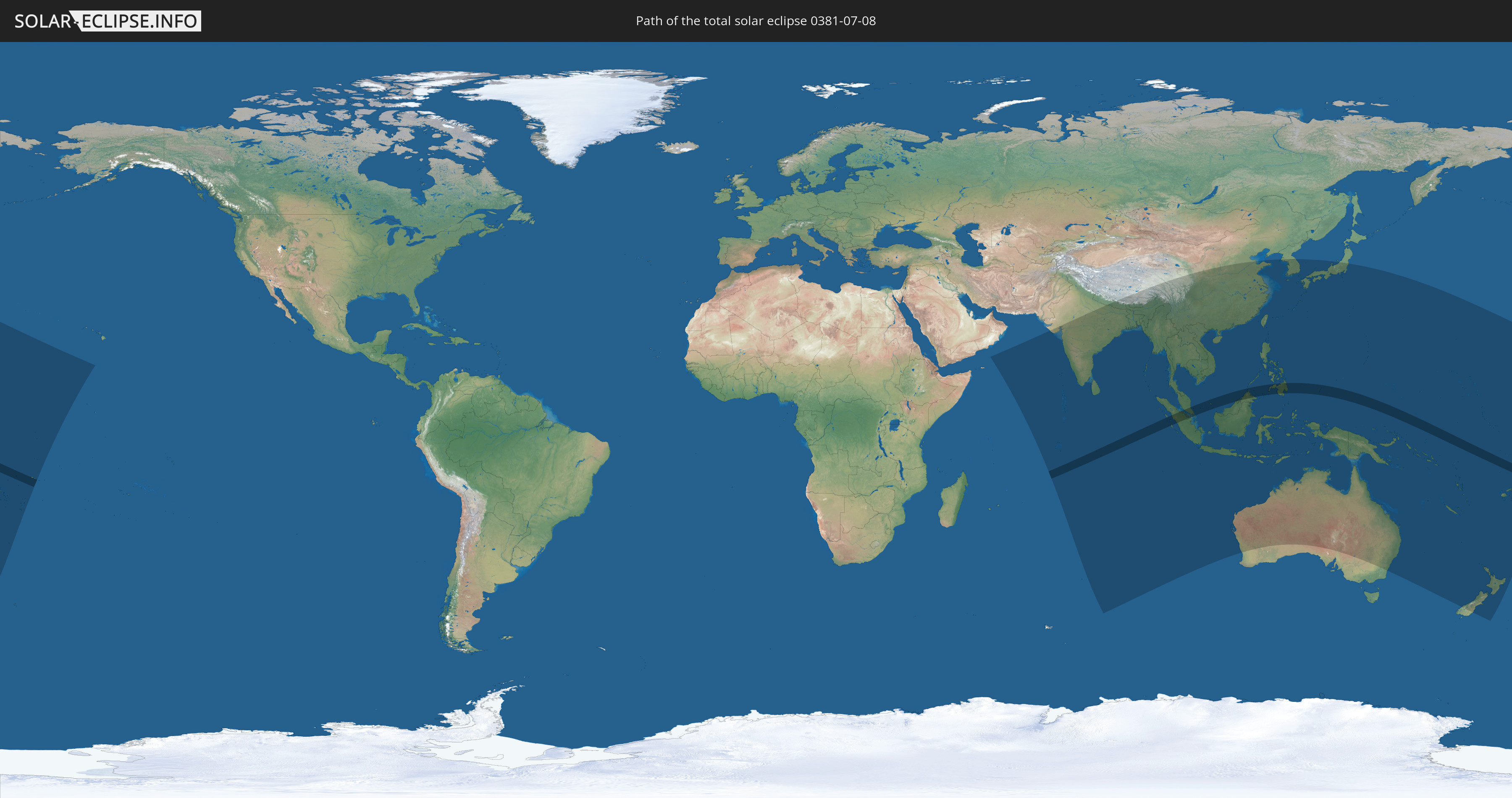
Total solar eclipse of 07/08/0381
| Day of week: | Wednesday |
| Maximum duration of eclipse: | 07m22s |
| Maximum width of eclipse path: | 264 km |
| Saros cycle: | 81 |
| Coverage: | 100% |
| Magnitude: | 1.0788 |
| Gamma: | -0.2612 |
Wo kann man die Sonnenfinsternis vom 07/08/0381 sehen?
Die Sonnenfinsternis am 07/08/0381 kann man in 49 Ländern als partielle Sonnenfinsternis beobachten.
Der Finsternispfad verläuft durch 9 Länder. Nur in diesen Ländern ist sie als total Sonnenfinsternis zu sehen.
In den folgenden Ländern ist die Sonnenfinsternis total zu sehen
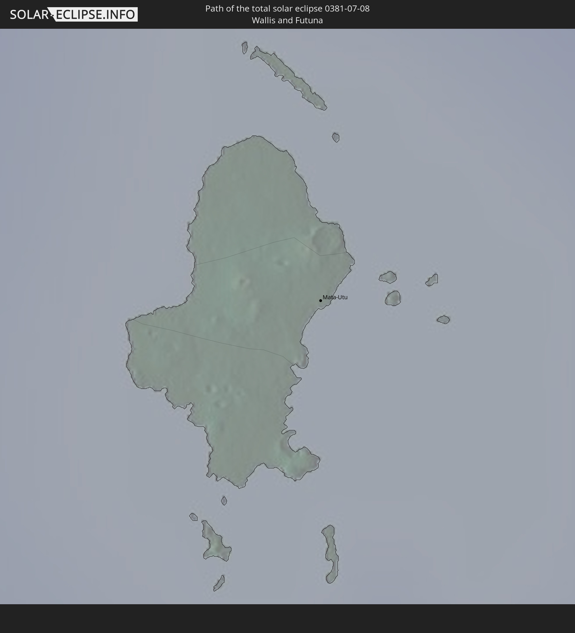 Wallis and Futuna
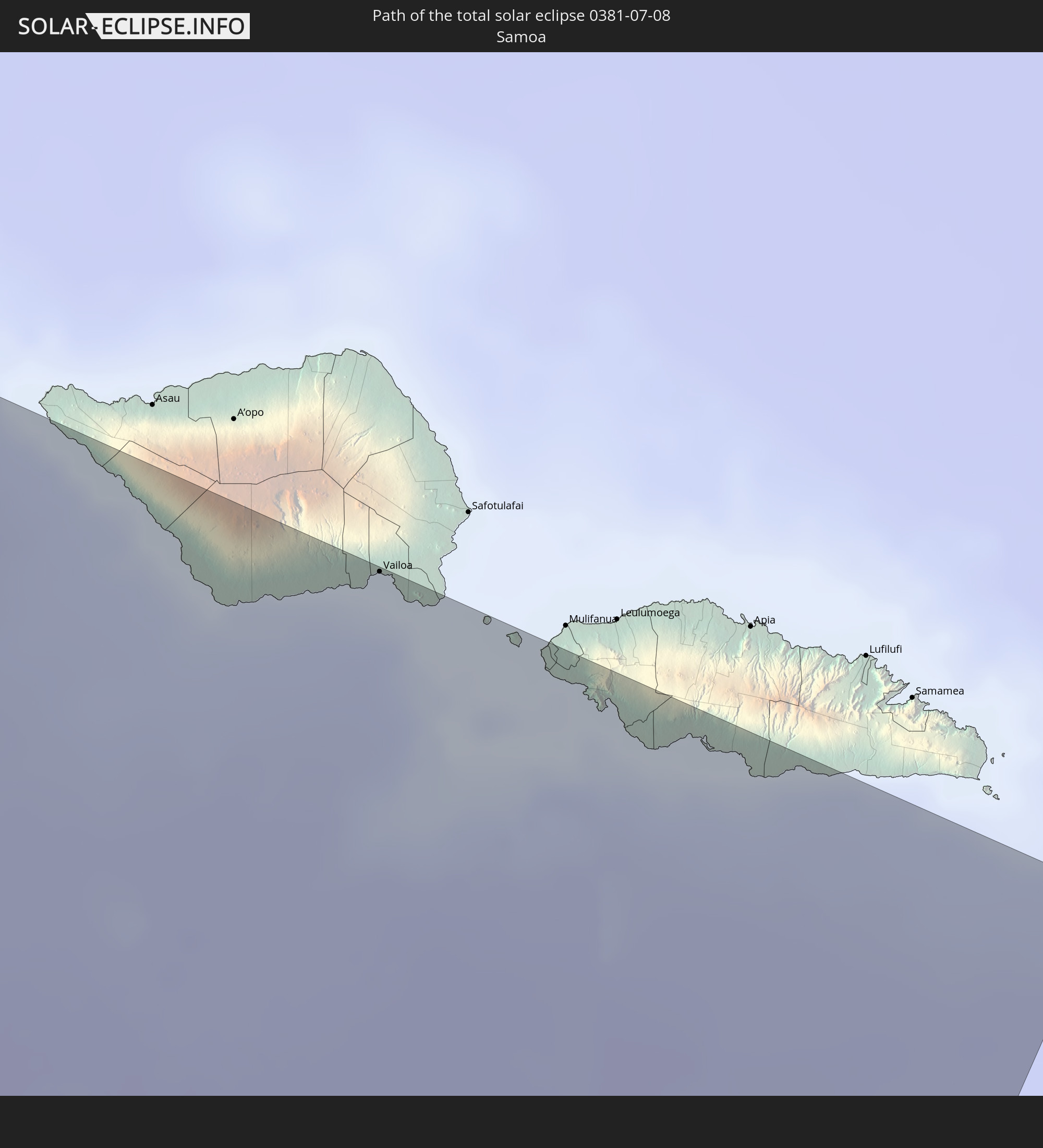 Samoa
Samoa
 Indonesia
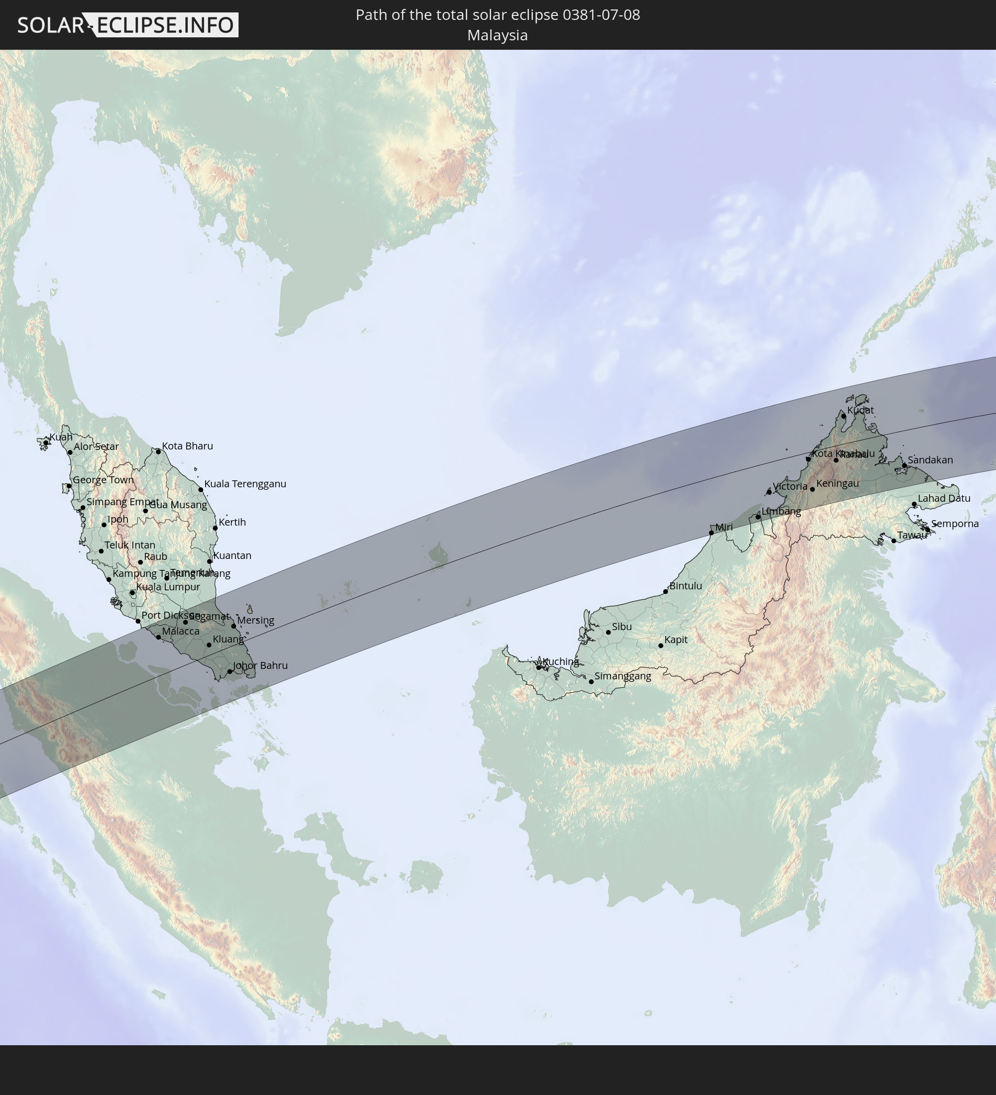 Malaysia
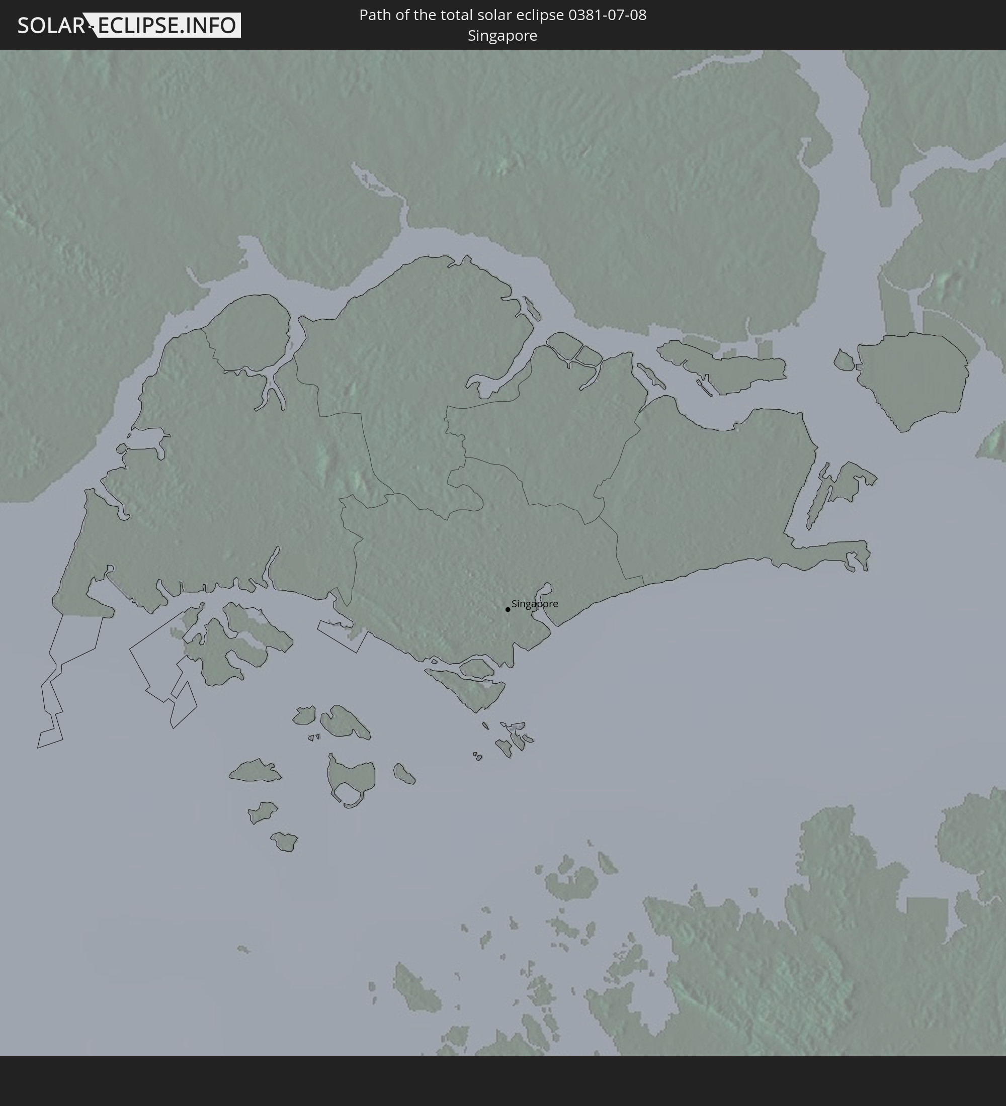 Singapore
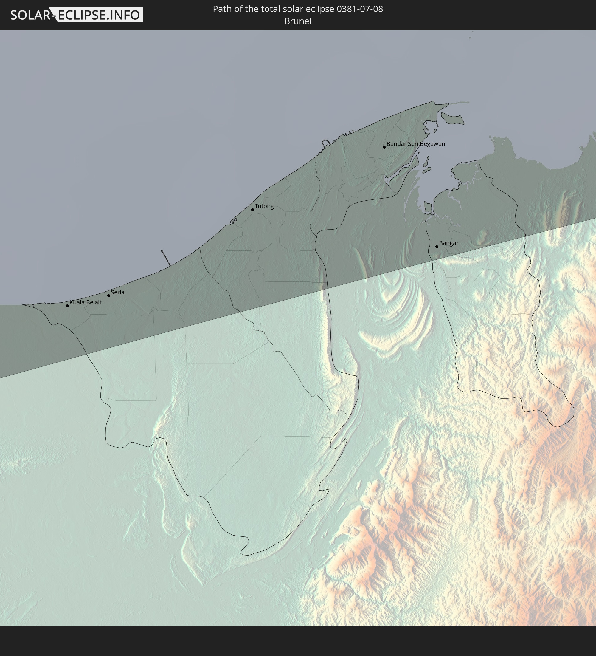 Brunei
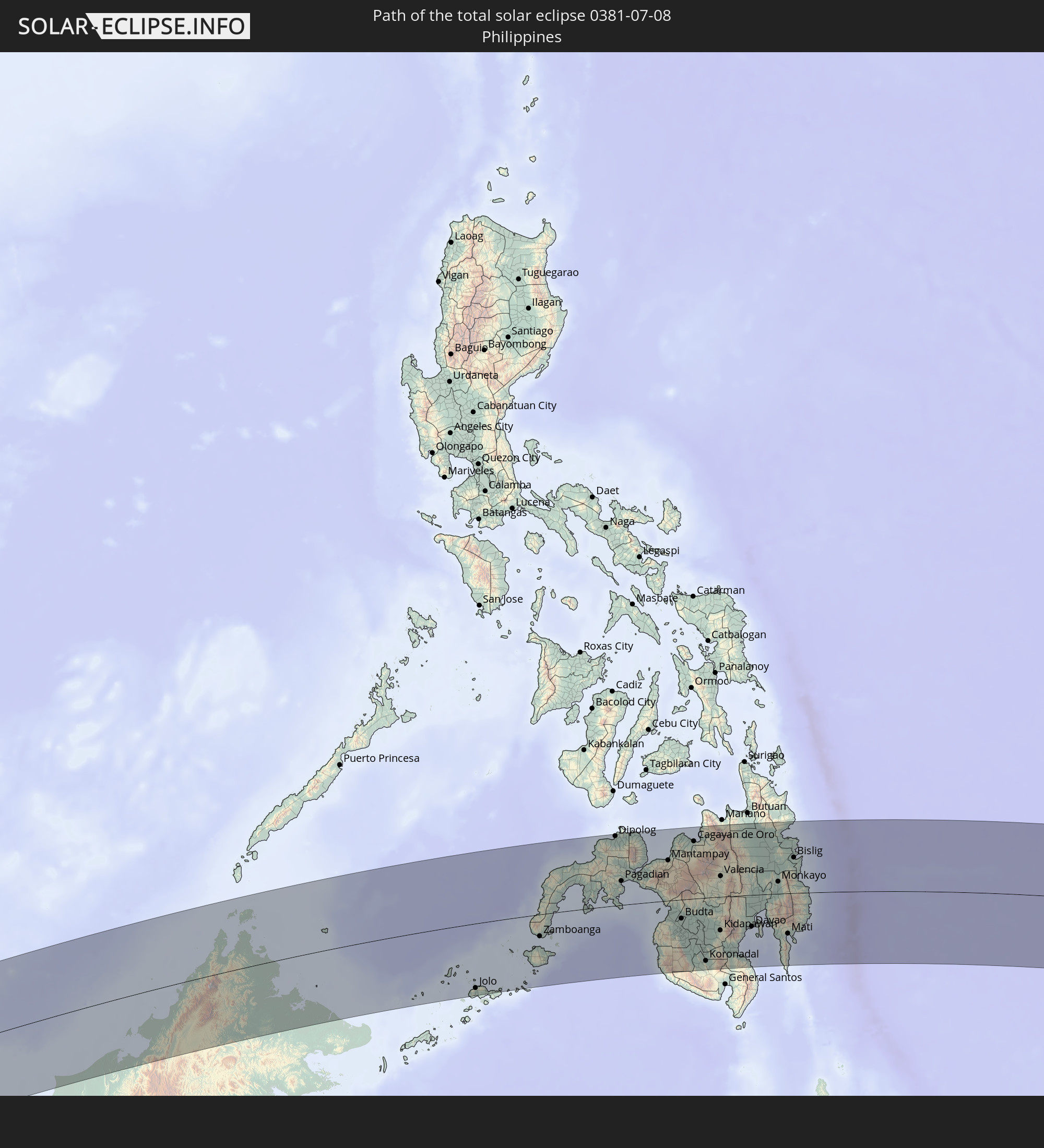 Philippines
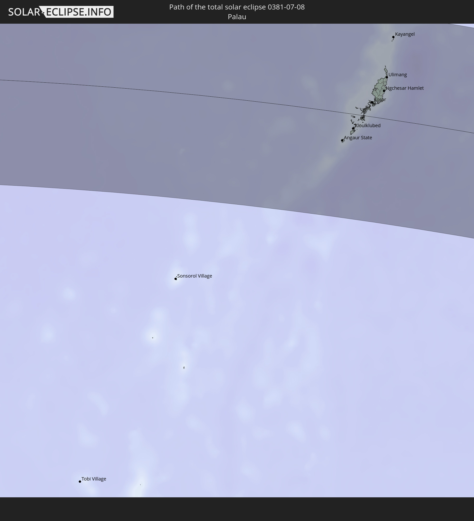 Palau
Palau
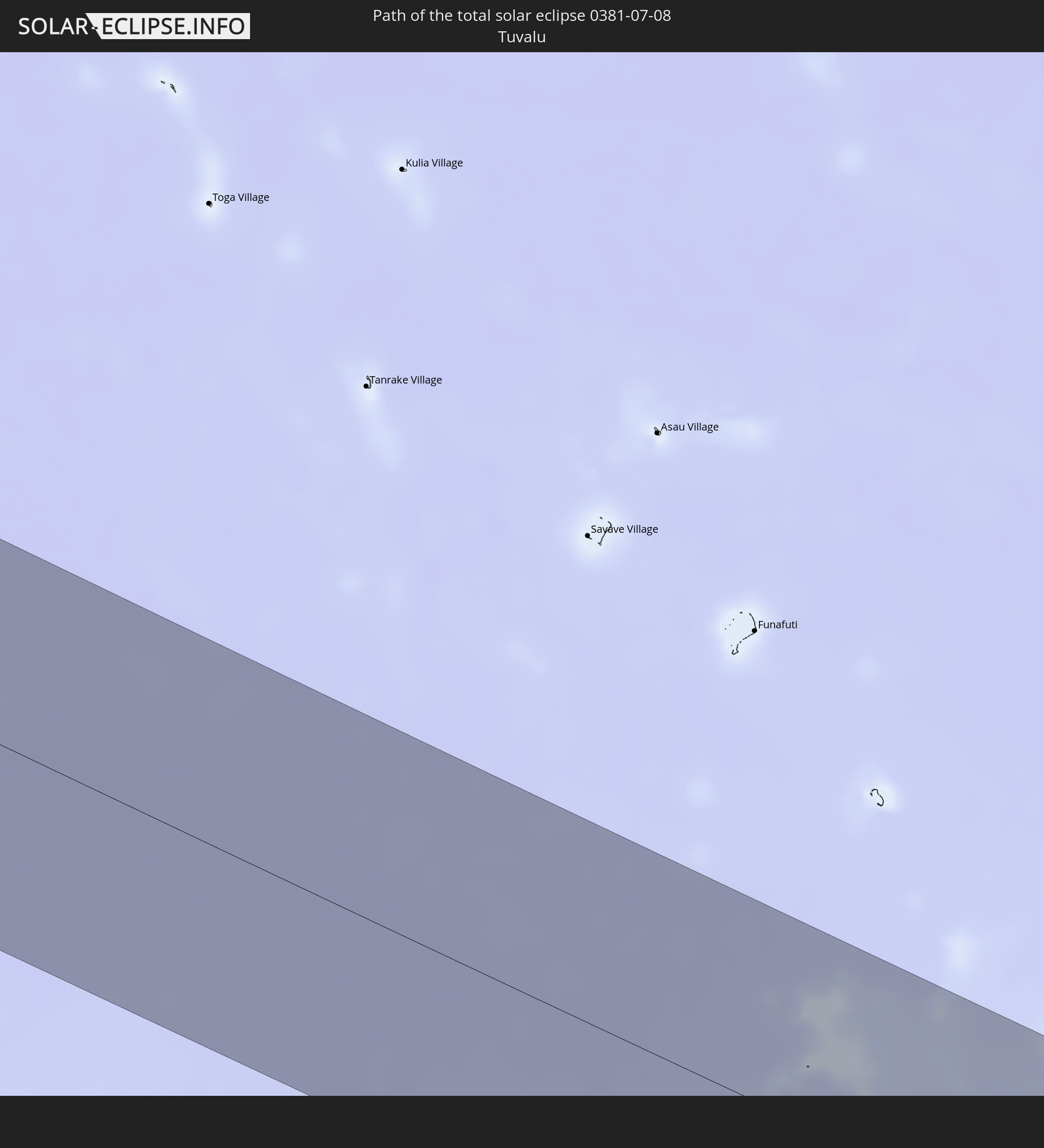 Tuvalu
In den folgenden Ländern ist die Sonnenfinsternis partiell zu sehen
 Fiji
Fiji
 New Zealand
 United States Minor Outlying Islands
 Wallis and Futuna
 Tonga
Tonga
 Kiribati
 Samoa
Samoa
 Tokelau
 American Samoa
 India
India
 British Indian Ocean Territory
 Maldives
 China
China
 Sri Lanka
 Nepal
Nepal
 Bangladesh
 Bhutan
 Myanmar
 Indonesia
 Cocos Islands
 Thailand
 Malaysia
 Laos
Laos
 Vietnam
 Cambodia
 Singapore
 Christmas Island
 Australia
 Macau
Macau
 Hong Kong
 Brunei
 Taiwan
 Philippines
 Japan
Japan
 East Timor
 North Korea
 South Korea
 Palau
Palau
 Federated States of Micronesia
 Papua New Guinea
 Guam
Guam
 Northern Mariana Islands
 Solomon Islands
 New Caledonia
 Marshall Islands
 Vanuatu
 Nauru
Nauru
 Norfolk Island
 Tuvalu
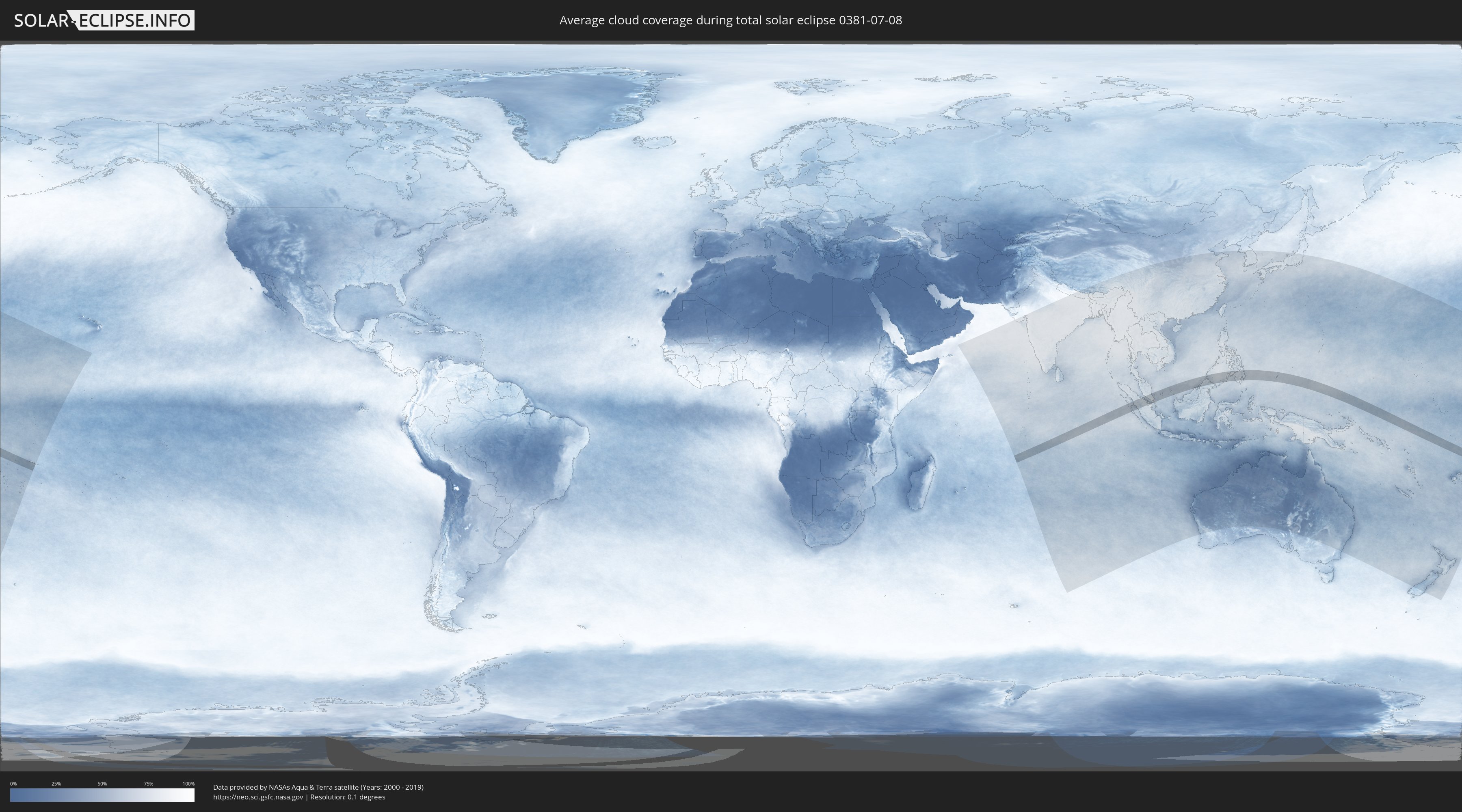
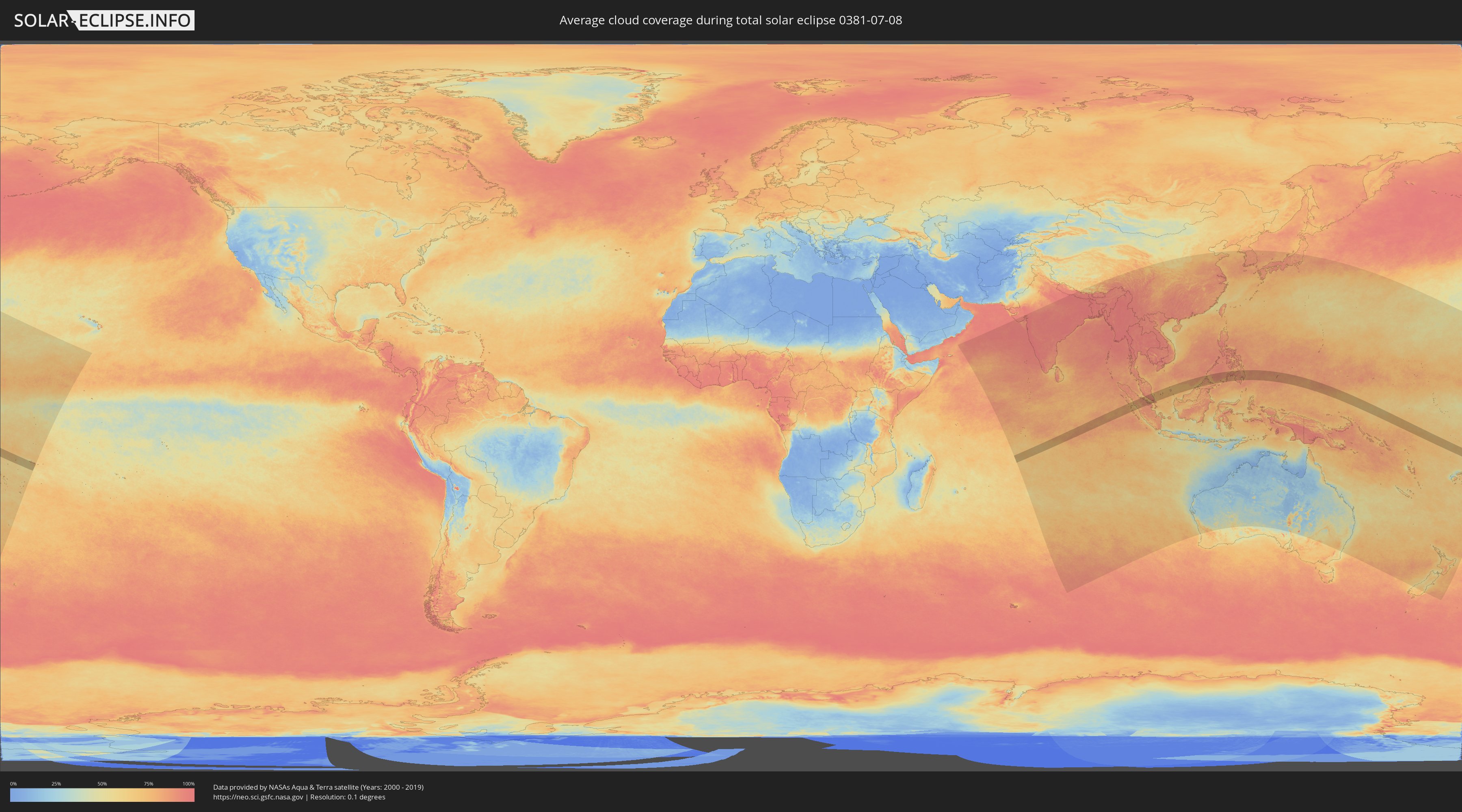
How will be the weather during the total solar eclipse on 07/08/0381?
Where is the best place to see the total solar eclipse of 07/08/0381?
The following maps show the average cloud coverage for the day of the total solar eclipse.
With the help of these maps, it is possible to find the place along the eclipse path, which has the best
chance of a cloudless sky.
Nevertheless, you should consider local circumstances and inform about the weather of your chosen
observation site.
The data is provided by NASAs satellites
AQUA and TERRA.
The cloud maps are averaged over a period of 19 years (2000 - 2019).
Detailed country maps
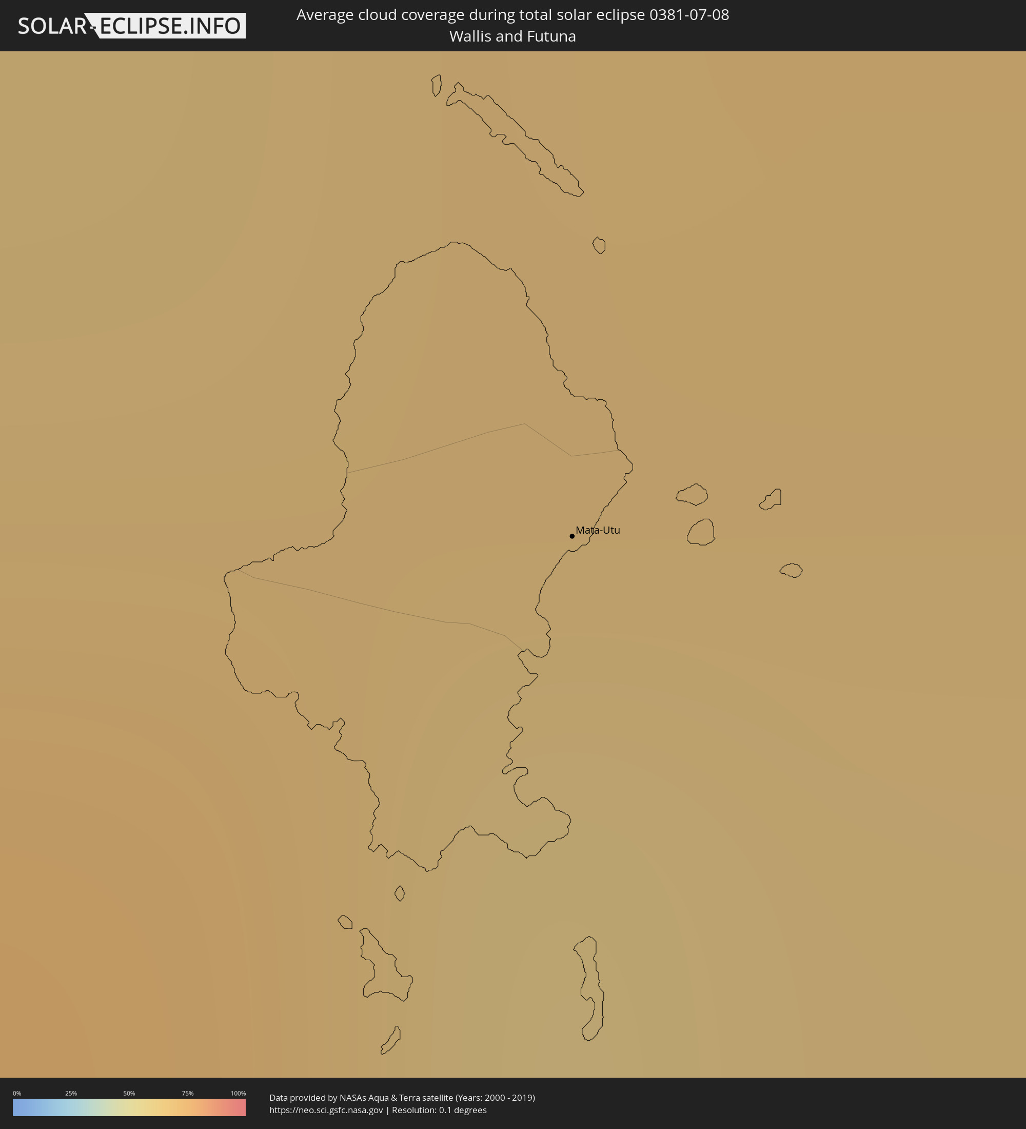 Wallis and Futuna
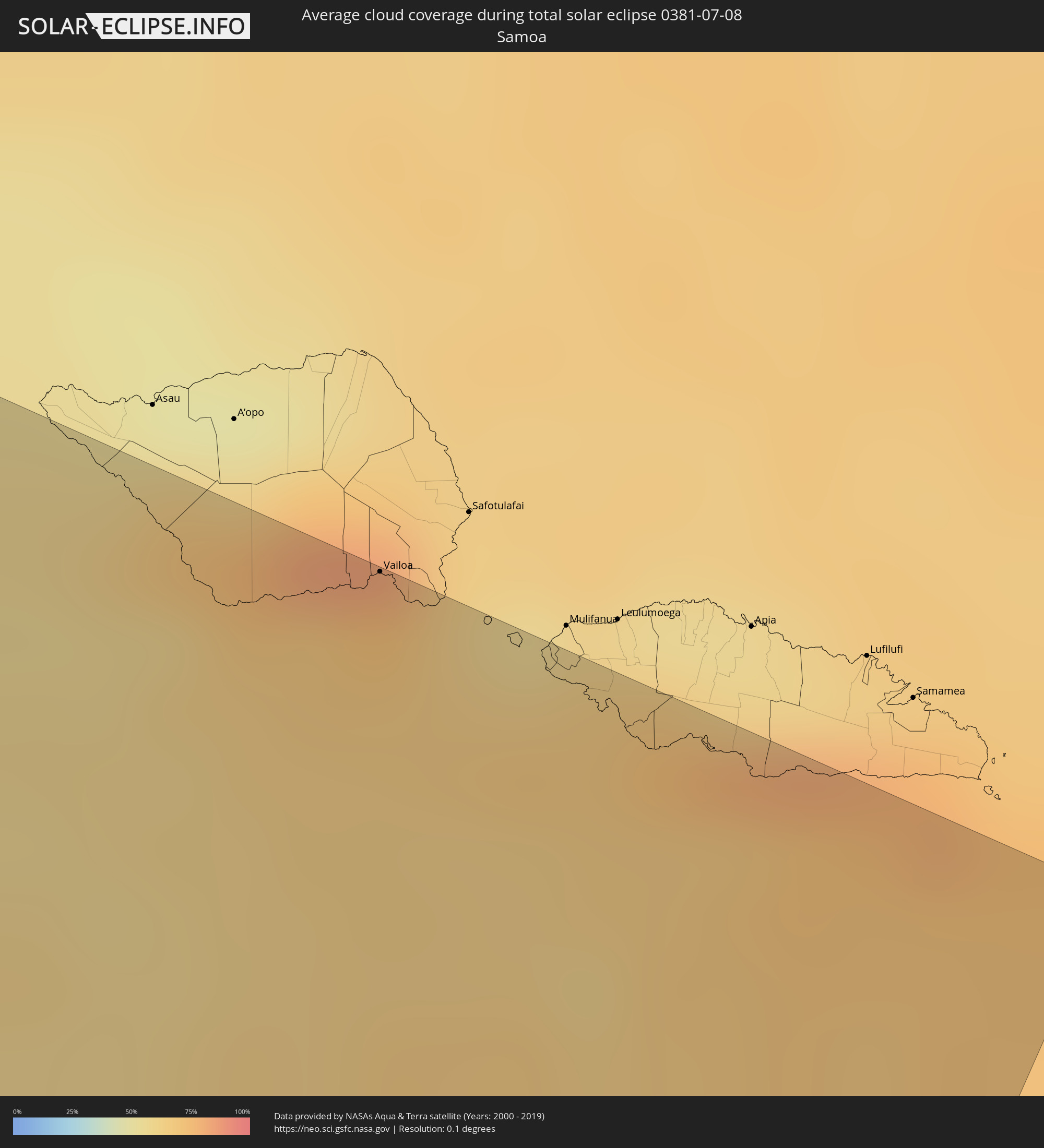 Samoa
Samoa
 Indonesia
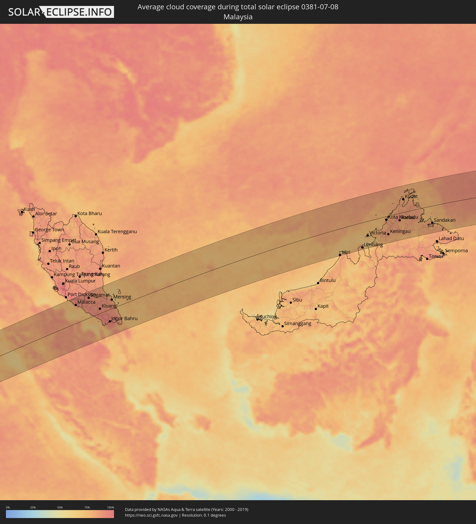 Malaysia
 Singapore
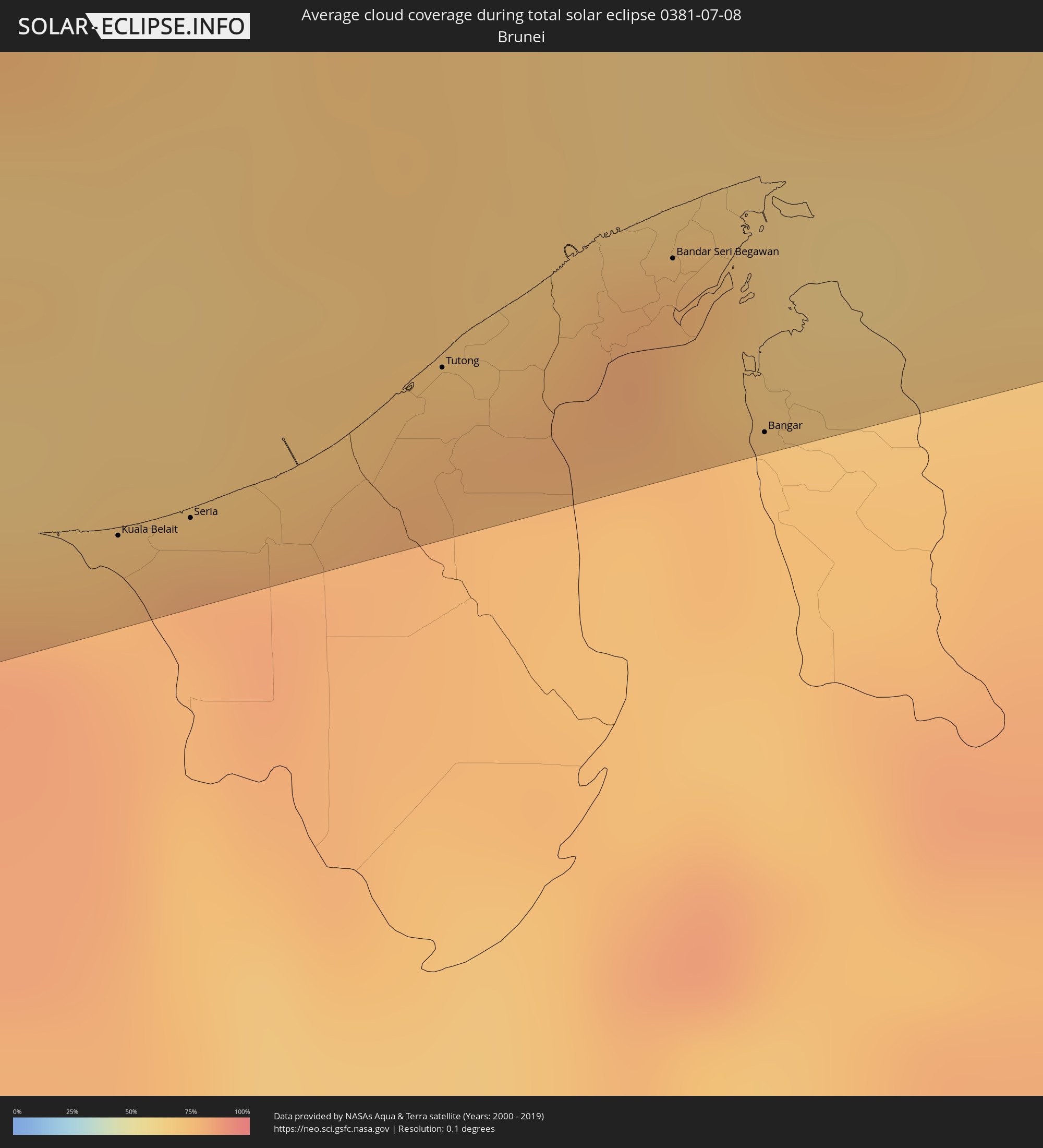 Brunei
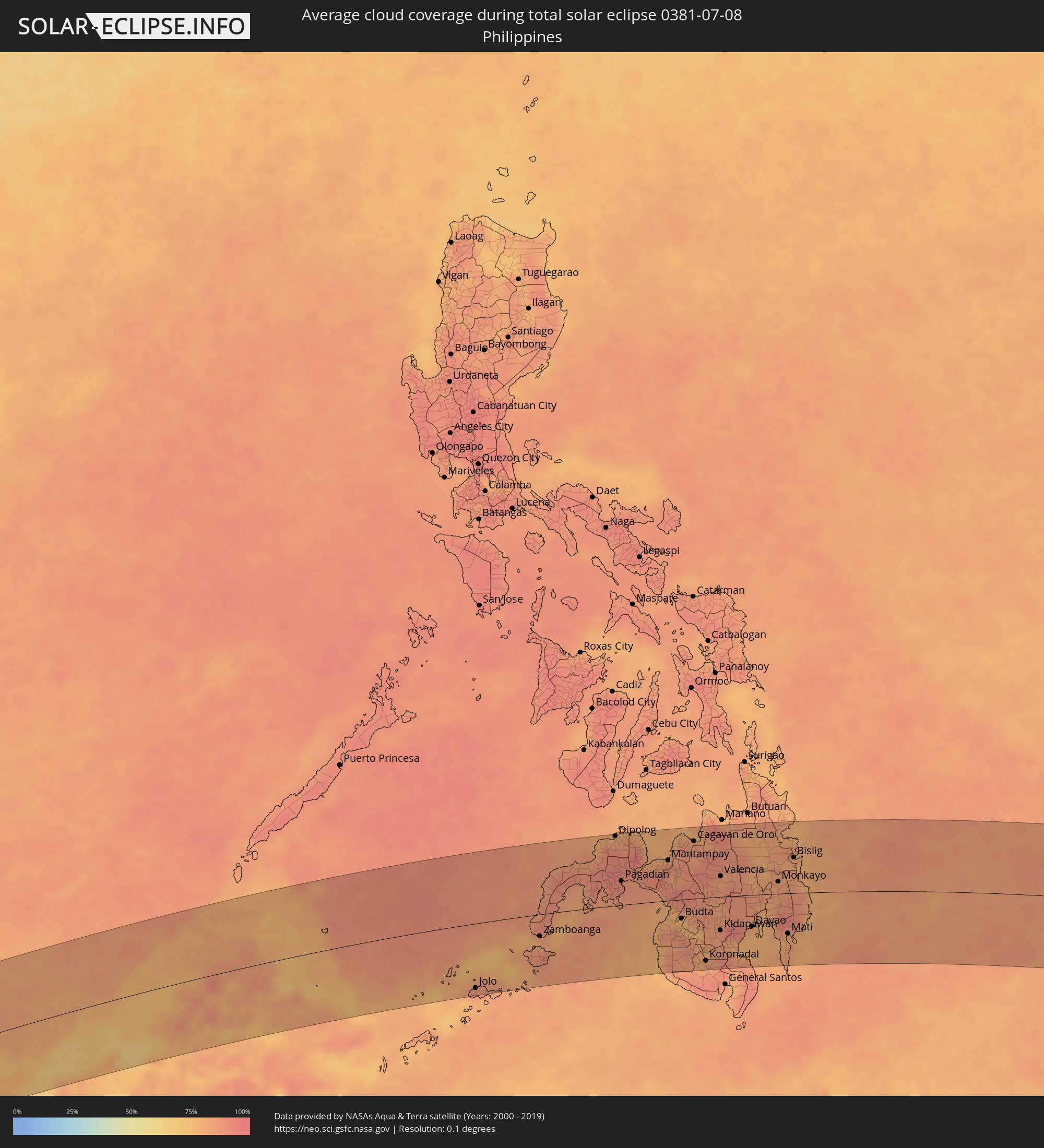 Philippines
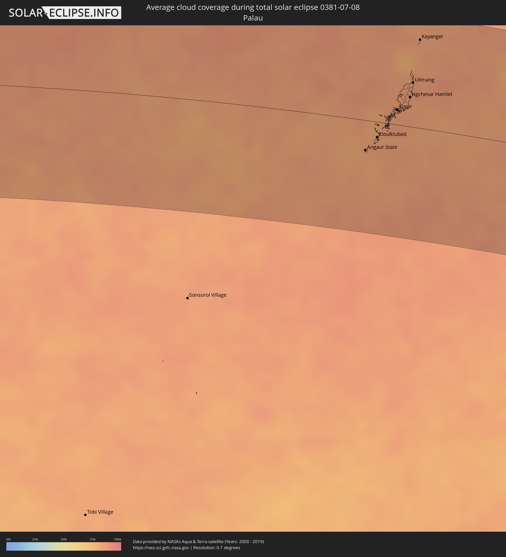 Palau
Palau
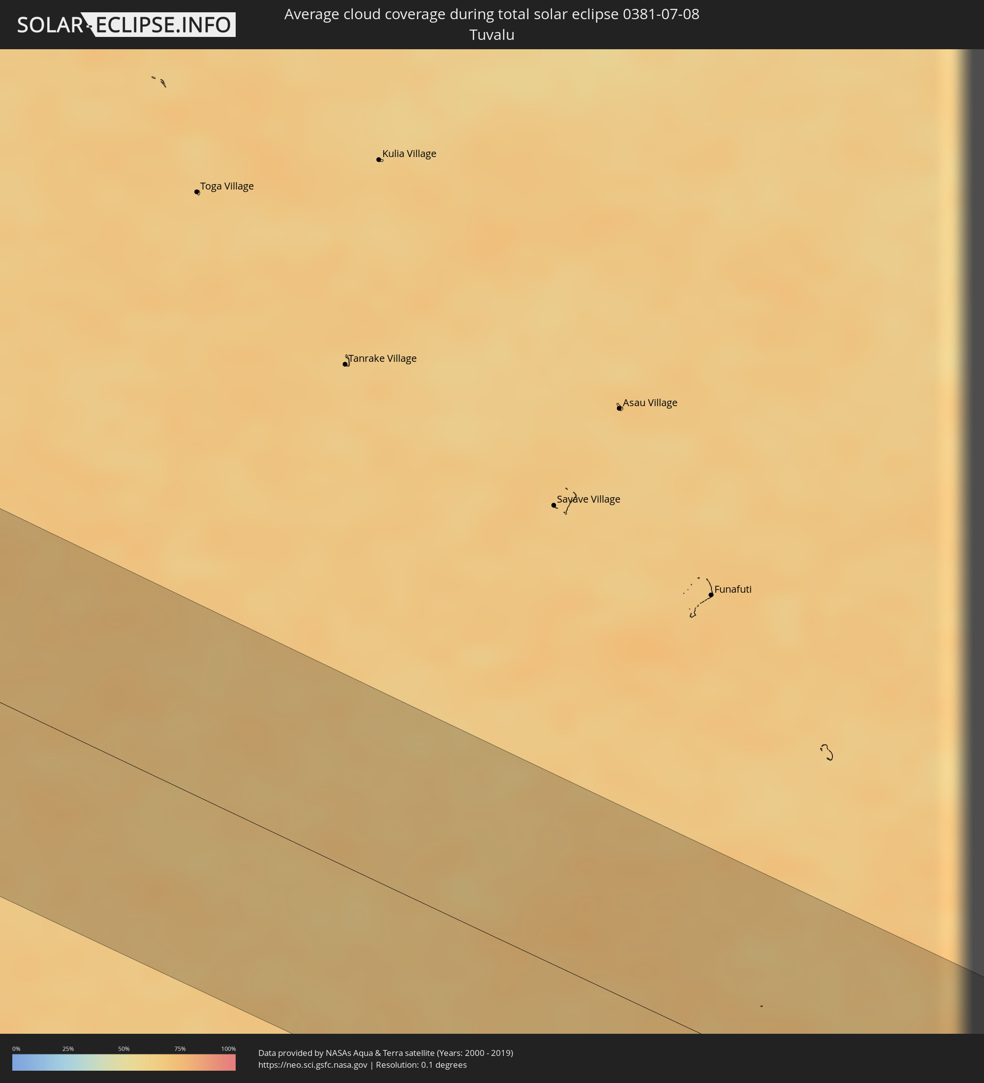 Tuvalu
Cities inside the path of the eclipse
The following table shows all locations with a population of more than 5,000 inside the eclipse path. Cities which have more than 100,000 inhabitants are marked bold. A click at the locations opens a detailed map.
| City | Type | Eclipse duration | Local time of max. eclipse | Distance to central line | Ø Cloud coverage |
|
Mata-Utu, Circonscription d'Uvéa
|
total | - | 17:01:40 UTC+12:00 | 23 km | 65% |
|
Vailoa, Palauli
|
total | - | 17:35:16 UTC-11:26 | 100 km | 67% |
|
Pariaman, West Sumatra
|
total | - | 09:13:08 UTC+07:07 | 113 km | 66% |
|
Bukittinggi, West Sumatra
|
total | - | 09:13:37 UTC+07:07 | 92 km | 85% |
|
Payakumbuh, West Sumatra
|
total | - | 09:14:04 UTC+07:07 | 95 km | 81% |
|
Balaipungut, Riau
|
total | - | 09:15:35 UTC+07:07 | 7 km | 84% |
|
Pekanbaru, Riau
|
total | - | 09:15:37 UTC+07:07 | 55 km | 92% |
|
Dumai, Riau
|
total | - | 09:16:05 UTC+07:07 | 63 km | 89% |
|
Kampong Masjid Tanah, Melaka
|
total | - | 09:05:41 UTC+06:55 | 104 km | 84% |
|
Sungai Udang, Melaka
|
total | - | 09:05:42 UTC+06:55 | 95 km | 73% |
|
Tampin, Negeri Sembilan
|
total | - | 09:05:56 UTC+06:55 | 112 km | 92% |
|
Malacca, Melaka
|
total | - | 09:05:50 UTC+06:55 | 83 km | 75% |
|
Batu Berendam, Melaka
|
total | - | 09:05:52 UTC+06:55 | 88 km | 75% |
|
Tangkak, Johor
|
total | - | 09:06:22 UTC+06:55 | 78 km | 90% |
|
Muar, Johor
|
total | - | 09:06:19 UTC+06:55 | 54 km | 72% |
|
Segamat, Johor
|
total | - | 09:06:56 UTC+06:55 | 92 km | 91% |
|
Batu Pahat, Johor
|
total | - | 09:06:52 UTC+06:55 | 19 km | 83% |
|
Yong Peng, Johor
|
total | - | 09:07:09 UTC+06:55 | 29 km | 92% |
|
Kluang, Johor
|
total | - | 09:07:36 UTC+06:55 | 21 km | 92% |
|
Pontian Kechil, Johor
|
total | - | 09:07:30 UTC+06:55 | 39 km | 80% |
|
Pekan Nenas, Johor
|
total | - | 09:07:44 UTC+06:55 | 41 km | 88% |
|
Taman Senai, Johor
|
total | - | 09:08:00 UTC+06:55 | 37 km | 95% |
|
Johor Bahru, Johor
|
total | - | 09:08:09 UTC+06:55 | 56 km | 94% |
|
Ulu Tiram, Johor
|
total | - | 09:08:18 UTC+06:55 | 45 km | 96% |
|
Mersing, Johor
|
total | - | 09:08:42 UTC+06:55 | 40 km | 87% |
|
Singapore, Central Singapore
|
total | - | 09:08:15 UTC+06:55 | 78 km | 83% |
|
Kota Tinggi, Johor
|
total | - | 09:08:31 UTC+06:55 | 34 km | 90% |
|
Miri, Sarawak
|
total | - | 09:57:38 UTC+07:21 | 126 km | 78% |
|
Kuala Belait, Belait
|
total | - | 10:16:36 UTC+07:39 | 115 km | 76% |
|
Seria, Belait
|
total | - | 10:16:52 UTC+07:39 | 115 km | 80% |
|
Tutong, Tutong
|
total | - | 10:17:47 UTC+07:39 | 104 km | 78% |
|
Bandar Seri Begawan, Brunei and Muara
|
total | - | 10:18:37 UTC+07:39 | 98 km | 81% |
|
Limbang, Sarawak
|
total | - | 10:00:21 UTC+07:21 | 120 km | 76% |
|
Bangar, Temburong
|
total | - | 10:18:51 UTC+07:39 | 125 km | 73% |
|
Victoria, Labuan
|
total | - | 10:01:11 UTC+07:21 | 70 km | 73% |
|
Kota Kinabalu, Sabah
|
total | - | 10:03:40 UTC+07:21 | 17 km | 84% |
|
Keningau, Sabah
|
total | - | 10:03:41 UTC+07:21 | 89 km | 79% |
|
Kudat, Sabah
|
total | - | 10:06:03 UTC+07:21 | 62 km | 81% |
|
Sandakan, Sabah
|
total | - | 10:09:18 UTC+07:21 | 83 km | 80% |
|
Jolo, Autonomous Region in Muslim Mindanao
|
total | - | 10:56:31 UTC+08:00 | 118 km | 86% |
|
City of Isabela, Autonomous Region in Muslim Mindanao
|
total | - | 10:59:36 UTC+08:00 | 61 km | 87% |
|
Zamboanga, Zamboanga Peninsula
|
total | - | 10:59:57 UTC+08:00 | 40 km | 83% |
|
Dipolog, Zamboanga Peninsula
|
total | - | 11:04:05 UTC+08:00 | 127 km | 82% |
|
Pagadian, Zamboanga Peninsula
|
total | - | 11:04:17 UTC+08:00 | 44 km | 91% |
|
Lala, Northern Mindanao
|
total | - | 11:05:15 UTC+08:00 | 57 km | 87% |
|
Ozamiz City, Northern Mindanao
|
total | - | 11:05:34 UTC+08:00 | 76 km | 84% |
|
Mantampay, Northern Mindanao
|
total | - | 11:06:44 UTC+08:00 | 74 km | 85% |
|
Cotabato, Autonomous Region in Muslim Mindanao
|
total | - | 11:06:43 UTC+08:00 | 31 km | 82% |
|
Marawi City, Autonomous Region in Muslim Mindanao
|
total | - | 11:06:55 UTC+08:00 | 55 km | 83% |
|
Iligan City, Soccsksargen
|
total | - | 11:07:19 UTC+08:00 | 82 km | 85% |
|
Budta, Autonomous Region in Muslim Mindanao
|
total | - | 11:07:19 UTC+08:00 | 35 km | 71% |
|
Cagayan de Oro, Northern Mindanao
|
total | - | 11:08:06 UTC+08:00 | 105 km | 85% |
|
Tacurong, Soccsksargen
|
total | - | 11:08:01 UTC+08:00 | 94 km | 83% |
|
Koronadal, Soccsksargen
|
total | - | 11:08:32 UTC+08:00 | 116 km | 84% |
|
Kidapawan, Soccsksargen
|
total | - | 11:09:21 UTC+08:00 | 62 km | 89% |
|
Valencia, Northern Mindanao
|
total | - | 11:09:26 UTC+08:00 | 38 km | 81% |
|
Malaybalay, Northern Mindanao
|
total | - | 11:09:34 UTC+08:00 | 66 km | 90% |
|
Digos, Davao
|
total | - | 11:10:11 UTC+08:00 | 92 km | 77% |
|
Davao, Davao
|
total | - | 11:11:01 UTC+08:00 | 58 km | 83% |
|
Panabo, Davao
|
total | - | 11:11:15 UTC+08:00 | 32 km | 80% |
|
Tagum, Davao
|
total | - | 11:11:39 UTC+08:00 | 17 km | 79% |
|
Monkayo, Davao
|
total | - | 11:12:27 UTC+08:00 | 22 km | 86% |
|
Mati, Davao
|
total | - | 11:12:56 UTC+08:00 | 74 km | 82% |
|
Bislig, Caraga
|
total | - | 11:13:17 UTC+08:00 | 66 km | 80% |
|
Angaur State, Angaur
|
total | - | 12:38:15 UTC+09:00 | 35 km | 82% |
|
Kloulklubed, Peleliu
|
total | - | 12:38:36 UTC+09:00 | 18 km | 83% |
|
Koror, Koror
|
total | - | 12:39:11 UTC+09:00 | 18 km | 84% |
|
Ngchemiangel, Aimeliik
|
total | - | 12:39:10 UTC+09:00 | 30 km | 84% |
|
Koror Town, Koror
|
total | - | 12:39:12 UTC+09:00 | 18 km | 84% |
|
Ngereklmadel, Ngatpang
|
total | - | 12:39:10 UTC+09:00 | 34 km | 84% |
|
Ngetkib, Airai
|
total | - | 12:39:18 UTC+09:00 | 21 km | 84% |
|
Imeong Hamlet, Ngaremlengui
|
total | - | 12:39:17 UTC+09:00 | 40 km | 84% |
|
Ngardmau, Ngardmau
|
total | - | 12:39:25 UTC+09:00 | 49 km | 85% |
|
Ngchesar Hamlet, Ngchesar
|
total | - | 12:39:34 UTC+09:00 | 34 km | 83% |
|
Melekeok, Melekeok
|
total | - | 12:39:36 UTC+09:00 | 38 km | 83% |
|
Mengellang, Ngarchelong
|
total | - | 12:39:33 UTC+09:00 | 60 km | 83% |
|
Ngerkeai, Ngiwal
|
total | - | 12:39:37 UTC+09:00 | 44 km | 85% |
|
Melekeok Village, Melekeok
|
total | - | 12:39:38 UTC+09:00 | 38 km | 83% |
|
Ulimang, Ngaraard
|
total | - | 12:39:37 UTC+09:00 | 52 km | 85% |
|
Kayangel, Kayangel
|
total | - | 12:39:42 UTC+09:00 | 104 km | 82% |