Total solar eclipse of 08/07/0389
| Day of week: | Monday |
| Maximum duration of eclipse: | 03m28s |
| Maximum width of eclipse path: | 127 km |
| Saros cycle: | 90 |
| Coverage: | 100% |
| Magnitude: | 1.0366 |
| Gamma: | -0.259 |
Wo kann man die Sonnenfinsternis vom 08/07/0389 sehen?
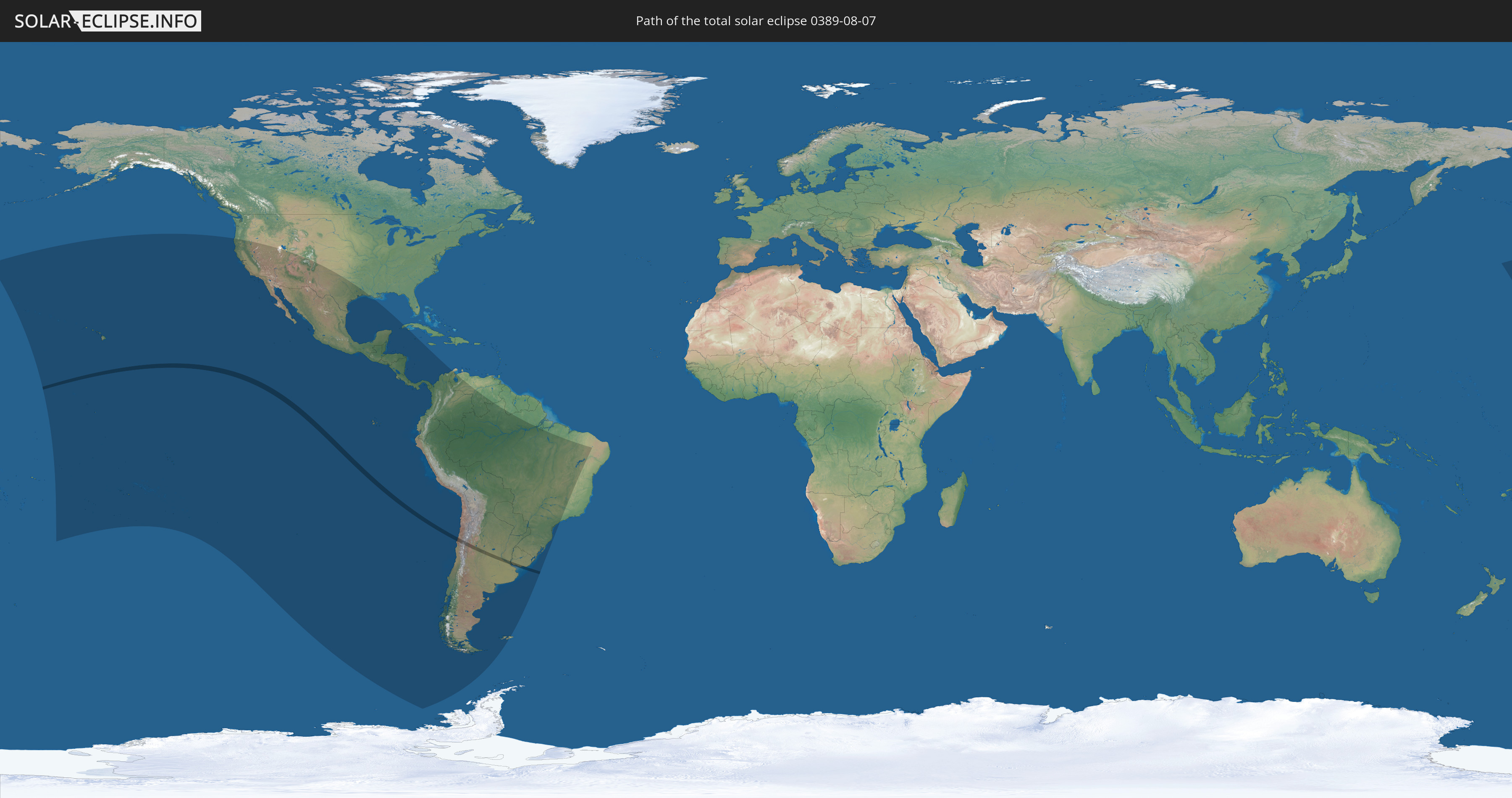
Die Sonnenfinsternis am 08/07/0389 kann man in 28 Ländern als partielle Sonnenfinsternis beobachten.
Der Finsternispfad verläuft durch 3 Länder. Nur in diesen Ländern ist sie als total Sonnenfinsternis zu sehen.
In den folgenden Ländern ist die Sonnenfinsternis total zu sehen
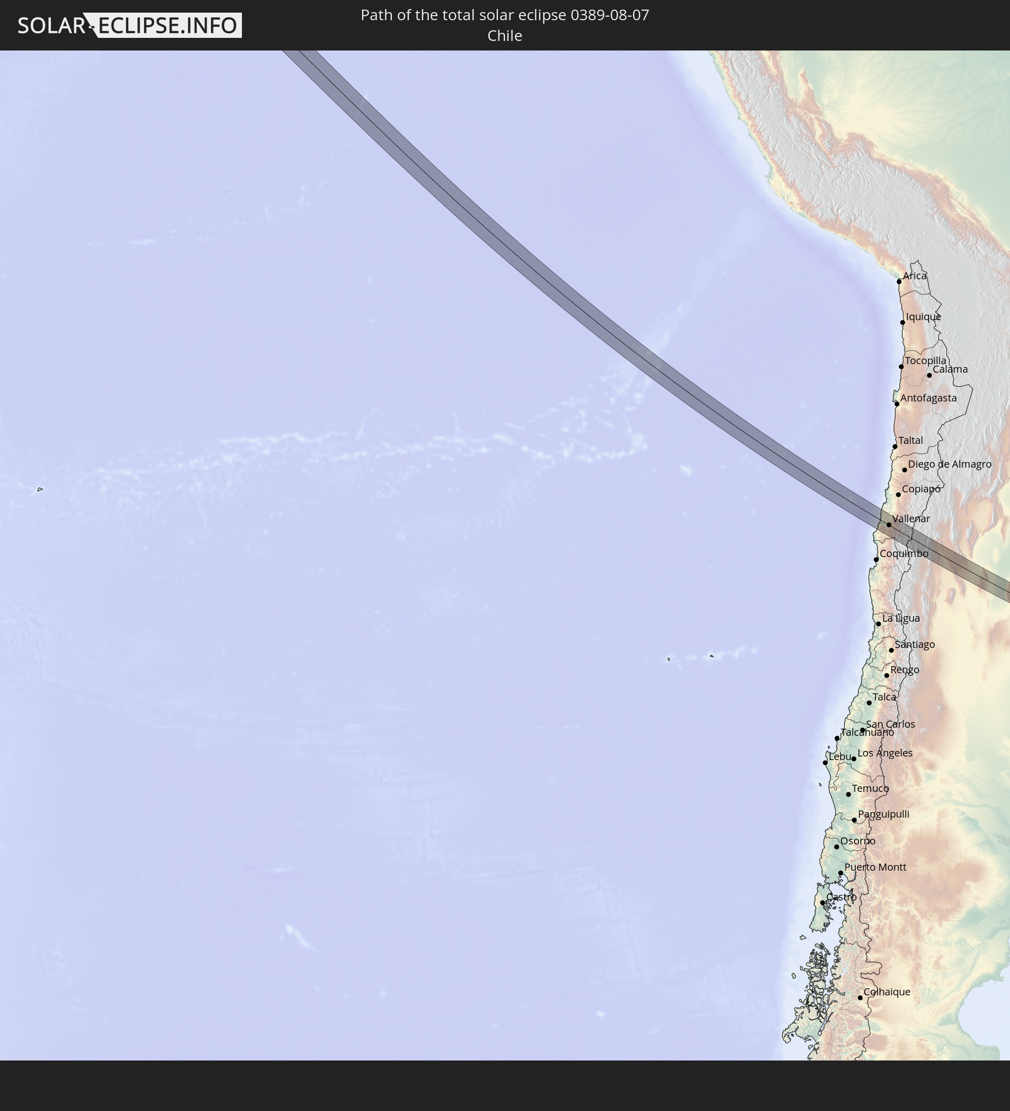 Chile
Chile
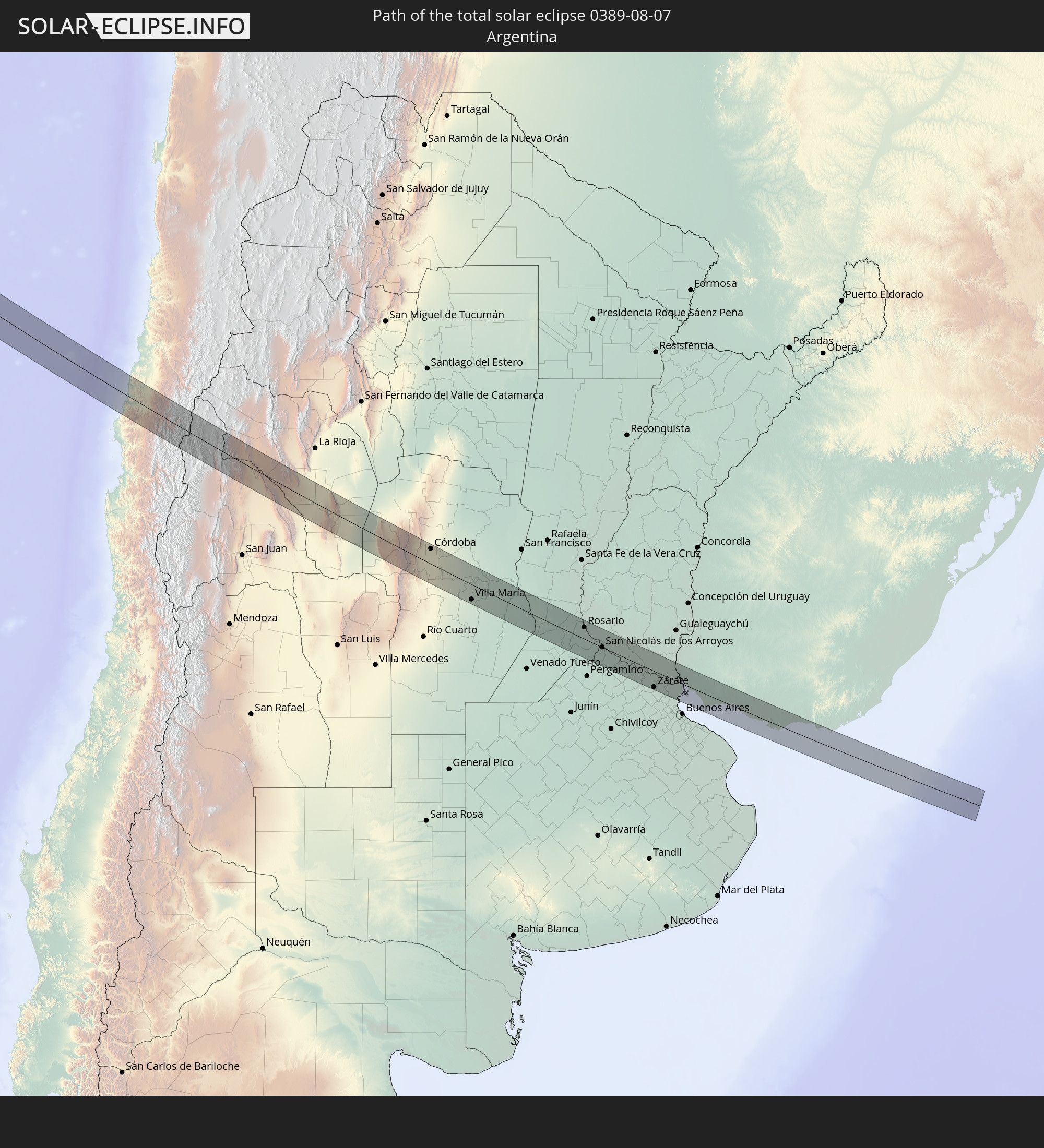 Argentina
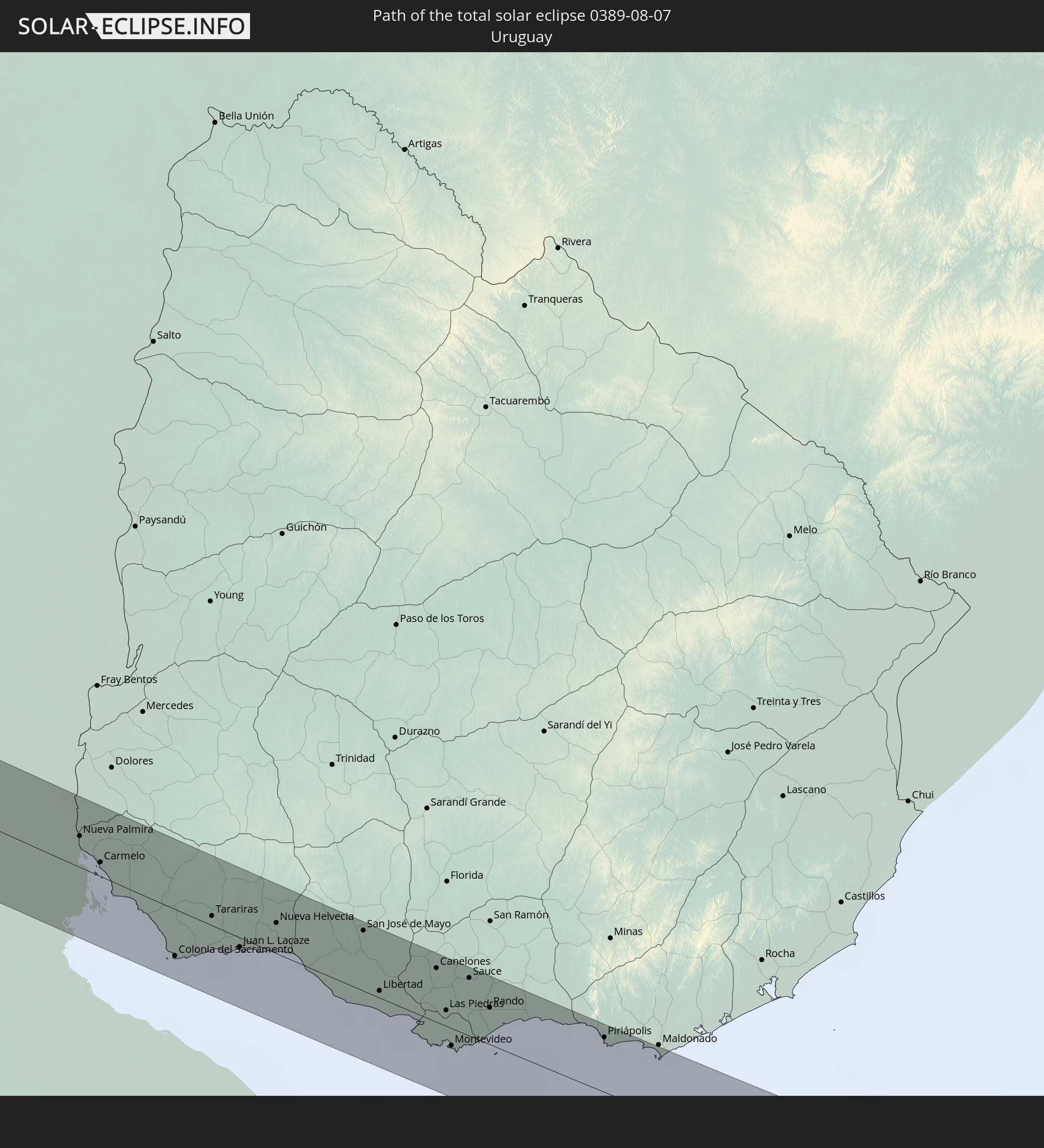 Uruguay
In den folgenden Ländern ist die Sonnenfinsternis partiell zu sehen
 United States
 United States Minor Outlying Islands
 Kiribati
 Cook Islands
 French Polynesia
 Pitcairn Islands
 Mexico
 Chile
Chile
 Guatemala
 Ecuador
 El Salvador
 Honduras
 Belize
 Nicaragua
 Costa Rica
 Cuba
Cuba
 Panama
 Colombia
 Cayman Islands
 Peru
Peru
 Brazil
 Argentina
 Venezuela
 Bolivia
 Paraguay
 Falkland Islands
 Guyana
 Uruguay
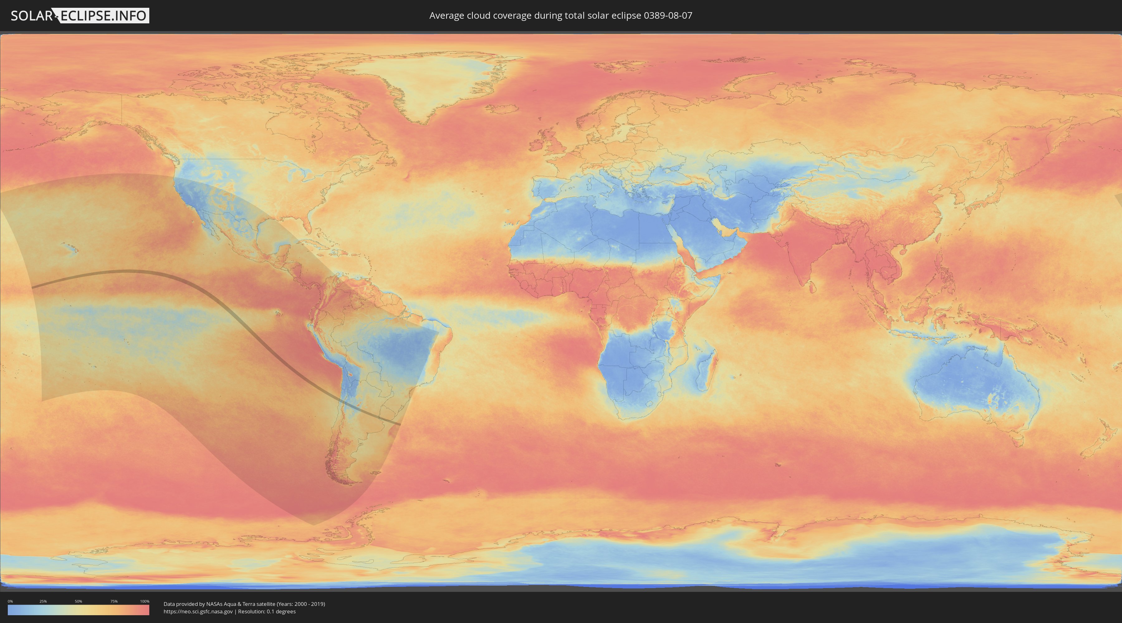
How will be the weather during the total solar eclipse on 08/07/0389?
Where is the best place to see the total solar eclipse of 08/07/0389?
The following maps show the average cloud coverage for the day of the total solar eclipse.
With the help of these maps, it is possible to find the place along the eclipse path, which has the best
chance of a cloudless sky.
Nevertheless, you should consider local circumstances and inform about the weather of your chosen
observation site.
The data is provided by NASAs satellites
AQUA and TERRA.
The cloud maps are averaged over a period of 19 years (2000 - 2019).

Detailed country maps
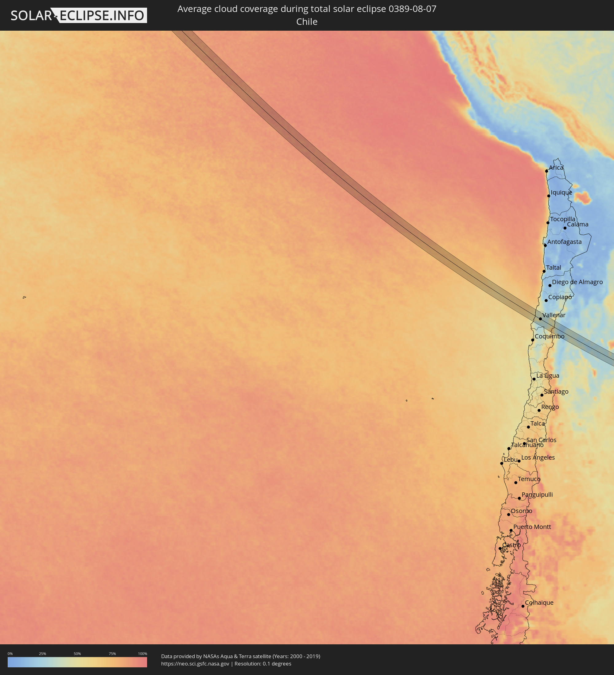 Chile
Chile
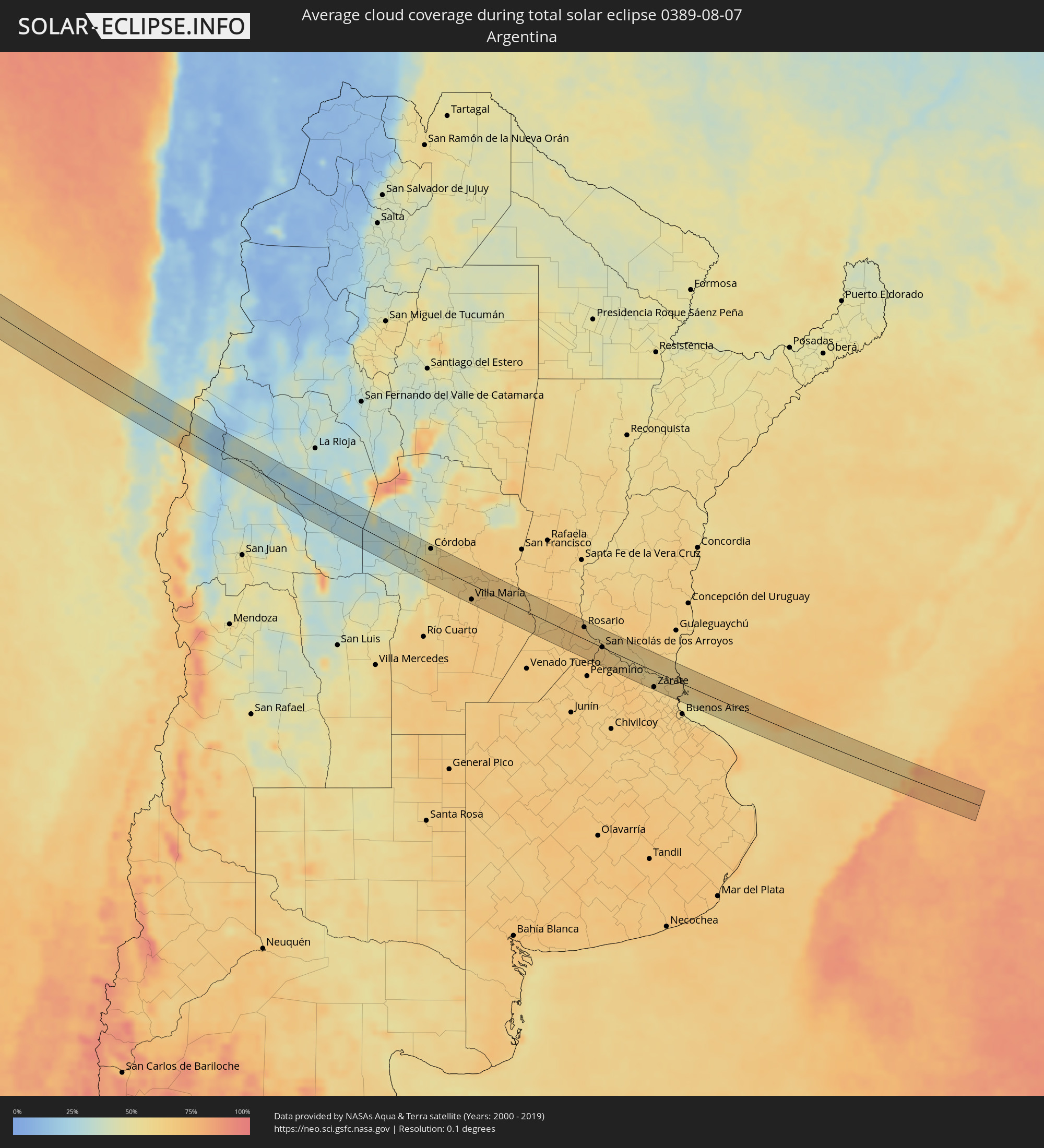 Argentina
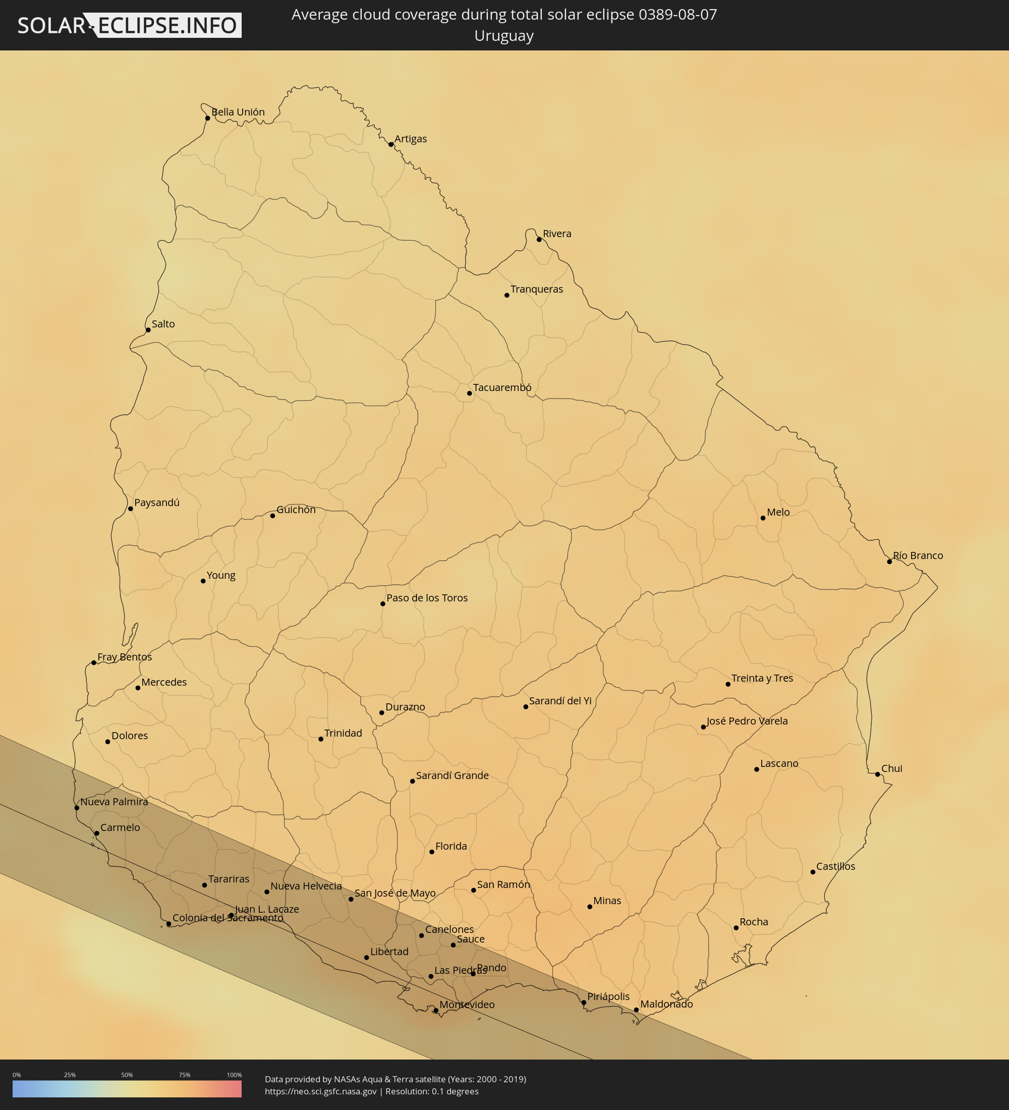 Uruguay
Cities inside the path of the eclipse
The following table shows all locations with a population of more than 5,000 inside the eclipse path. Cities which have more than 100,000 inhabitants are marked bold. A click at the locations opens a detailed map.
| City | Type | Eclipse duration | Local time of max. eclipse | Distance to central line | Ø Cloud coverage |
|
Vallenar, Atacama
|
total | - | 15:50:30 UTC-04:42 | 0 km | 39% |
|
Chamical, La Rioja Province
|
total | - | 16:19:10 UTC-04:16 | 39 km | 31% |
|
Mina Clavero, Cordoba Province
|
total | - | 16:19:50 UTC-04:16 | 37 km | 36% |
|
Villa Carlos Paz, Cordoba Province
|
total | - | 16:20:02 UTC-04:16 | 15 km | 42% |
|
Cosquín, Cordoba Province
|
total | - | 16:20:02 UTC-04:16 | 34 km | 40% |
|
Alta Gracia, Cordoba Province
|
total | - | 16:20:04 UTC-04:16 | 5 km | 50% |
|
Malagueño, Cordoba Province
|
total | - | 16:20:06 UTC-04:16 | 17 km | 53% |
|
La Calera, Cordoba Province
|
total | - | 16:20:06 UTC-04:16 | 30 km | 50% |
|
Villa Allende, Cordoba Province
|
total | - | 16:20:07 UTC-04:16 | 36 km | 50% |
|
Despeñaderos, Cordoba Province
|
total | - | 16:20:08 UTC-04:16 | 15 km | 56% |
|
Córdoba, Cordoba Province
|
total | - | 16:20:10 UTC-04:16 | 29 km | 55% |
|
Malvinas Argentinas, Cordoba Province
|
total | - | 16:20:12 UTC-04:16 | 37 km | 53% |
|
Río Segundo, Cordoba Province
|
total | - | 16:20:17 UTC-04:16 | 17 km | 63% |
|
Pilar, Cordoba Province
|
total | - | 16:20:18 UTC-04:16 | 16 km | 63% |
|
Laguna Larga, Cordoba Province
|
total | - | 16:20:20 UTC-04:16 | 10 km | 60% |
|
Oncativo, Cordoba Province
|
total | - | 16:20:23 UTC-04:16 | 1 km | 62% |
|
Oliva, Cordoba Province
|
total | - | 16:20:25 UTC-04:16 | 7 km | 64% |
|
Villa Nueva, Cordoba Province
|
total | - | 16:20:32 UTC-04:16 | 32 km | 64% |
|
Villa María, Cordoba Province
|
total | - | 16:20:33 UTC-04:16 | 29 km | 64% |
|
Pozo del Molle, Cordoba Province
|
total | - | 16:20:40 UTC-04:16 | 23 km | 65% |
|
Bell Ville, Cordoba Province
|
total | - | 16:20:44 UTC-04:16 | 28 km | 64% |
|
Leones, Cordoba Province
|
total | - | 16:20:52 UTC-04:16 | 15 km | 64% |
|
Marcos Juárez, Cordoba Province
|
total | - | 16:20:56 UTC-04:16 | 11 km | 64% |
|
Cruz Alta, Cordoba Province
|
total | - | 16:21:02 UTC-04:16 | 30 km | 65% |
|
Armstrong, Santa Fe Province
|
total | - | 16:21:06 UTC-04:16 | 1 km | 63% |
|
Las Rosas, Santa Fe Province
|
total | - | 16:21:07 UTC-04:16 | 32 km | 65% |
|
Las Parejas, Santa Fe Province
|
total | - | 16:21:08 UTC-04:16 | 14 km | 64% |
|
Cañada de Gómez, Santa Fe Province
|
total | - | 16:21:10 UTC-04:16 | 6 km | 65% |
|
Casilda, Santa Fe Province
|
total | - | 16:21:14 UTC-04:16 | 8 km | 66% |
|
Carcarañá, Santa Fe Province
|
total | - | 16:21:14 UTC-04:16 | 11 km | 68% |
|
Roldán, Santa Fe Province
|
total | - | 16:21:19 UTC-04:16 | 17 km | 69% |
|
Funes, Santa Fe Province
|
total | - | 16:21:21 UTC-04:16 | 19 km | 69% |
|
Pérez, Santa Fe Province
|
total | - | 16:21:21 UTC-04:16 | 13 km | 70% |
|
Fray Luis A. Beltrán, Santa Fe Province
|
total | - | 16:21:22 UTC-04:16 | 35 km | 66% |
|
Capitán Bermúdez, Santa Fe Province
|
total | - | 16:21:23 UTC-04:16 | 32 km | 66% |
|
Granadero Baigorria, Santa Fe Province
|
total | - | 16:21:22 UTC-04:16 | 29 km | 69% |
|
Gobernador Gálvez, Santa Fe Province
|
total | - | 16:21:23 UTC-04:16 | 14 km | 66% |
|
Rosario, Santa Fe Province
|
total | - | 16:21:24 UTC-04:16 | 23 km | 62% |
|
Arroyo Seco, Santa Fe Province
|
total | - | 16:21:25 UTC-04:16 | 7 km | 69% |
|
Villa Constitución, Santa Fe Province
|
total | - | 16:21:28 UTC-04:16 | 7 km | 66% |
|
San Nicolás de los Arroyos, Buenos Aires
|
total | - | 16:21:30 UTC-04:16 | 0 km | 65% |
|
Zárate, Buenos Aires
|
total | - | 16:21:45 UTC-04:16 | 31 km | 63% |
|
Campana, Buenos Aires
|
total | - | 16:21:45 UTC-04:16 | 35 km | 64% |
|
Nueva Palmira, Colonia
|
total | - | 16:53:52 UTC-03:44 | 16 km | 60% |
|
Carmelo, Colonia
|
total | - | 16:53:53 UTC-03:44 | 7 km | 58% |
|
Colonia del Sacramento, Colonia
|
total | - | 16:53:56 UTC-03:44 | 23 km | 53% |
|
Tarariras, Colonia
|
total | - | 16:54:00 UTC-03:44 | 5 km | 66% |
|
Juan L. Lacaze, Colonia
|
total | - | 16:54:01 UTC-03:44 | 5 km | 60% |
|
Rosario, Colonia
|
total | - | 16:54:03 UTC-03:44 | 9 km | 67% |
|
Nueva Helvecia, Colonia
|
total | - | 16:54:05 UTC-03:44 | 15 km | 66% |
|
San José de Mayo, San José
|
total | - | 16:54:11 UTC-03:44 | 30 km | 69% |
|
Libertad, San José
|
total | - | 16:54:10 UTC-03:44 | 4 km | 68% |
|
Santa Lucía, Canelones
|
total | - | 16:54:14 UTC-03:44 | 30 km | 68% |
|
Delta del Tigre, San José
|
total | - | 16:54:11 UTC-03:44 | 1 km | 63% |
|
Canelones, Canelones
|
total | - | 16:54:15 UTC-03:44 | 27 km | 68% |
|
La Paz, Canelones
|
total | - | 16:54:13 UTC-03:44 | 5 km | 71% |
|
Las Piedras, Canelones
|
total | - | 16:54:13 UTC-03:44 | 8 km | 73% |
|
Progreso, Canelones
|
total | - | 16:54:14 UTC-03:44 | 14 km | 73% |
|
Montevideo, Montevideo
|
total | - | 16:54:12 UTC-03:44 | 9 km | 62% |
|
Sauce, Canelones
|
total | - | 16:54:16 UTC-03:44 | 29 km | 70% |
|
Paso de Carrasco, Canelones
|
total | - | 16:54:14 UTC-03:44 | 1 km | 60% |
|
Joaquín Suárez, Canelones
|
total | - | 16:54:15 UTC-03:44 | 14 km | 70% |
|
Colonia Nicolich, Canelones
|
total | - | 16:54:15 UTC-03:44 | 6 km | 67% |
|
Pando, Canelones
|
total | - | 16:54:16 UTC-03:44 | 19 km | 70% |
|
Piriápolis, Maldonado
|
total | - | 16:54:22 UTC-03:44 | 28 km | 61% |
|
Punta del Este, Maldonado
|
total | - | 16:54:24 UTC-03:44 | 31 km | 63% |