Annular solar eclipse of 01/12/0400
| Day of week: | Wednesday |
| Maximum duration of eclipse: | 08m44s |
| Maximum width of eclipse path: | 291 km |
| Saros cycle: | 86 |
| Coverage: | 92.6% |
| Magnitude: | 0.9257 |
| Gamma: | -0.2735 |
Wo kann man die Sonnenfinsternis vom 01/12/0400 sehen?
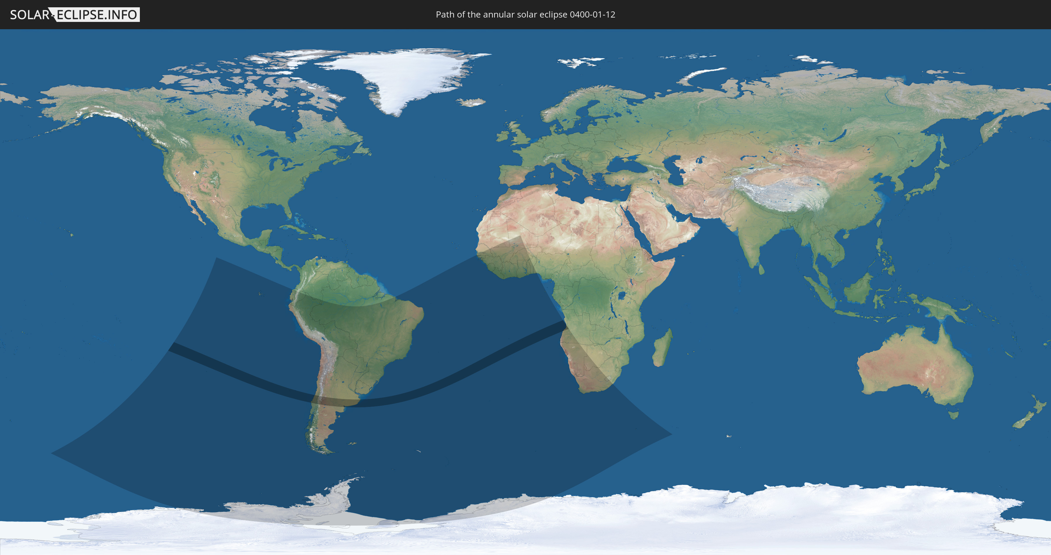
Die Sonnenfinsternis am 01/12/0400 kann man in 37 Ländern als partielle Sonnenfinsternis beobachten.
Der Finsternispfad verläuft durch 3 Länder. Nur in diesen Ländern ist sie als annular Sonnenfinsternis zu sehen.
In den folgenden Ländern ist die Sonnenfinsternis annular zu sehen
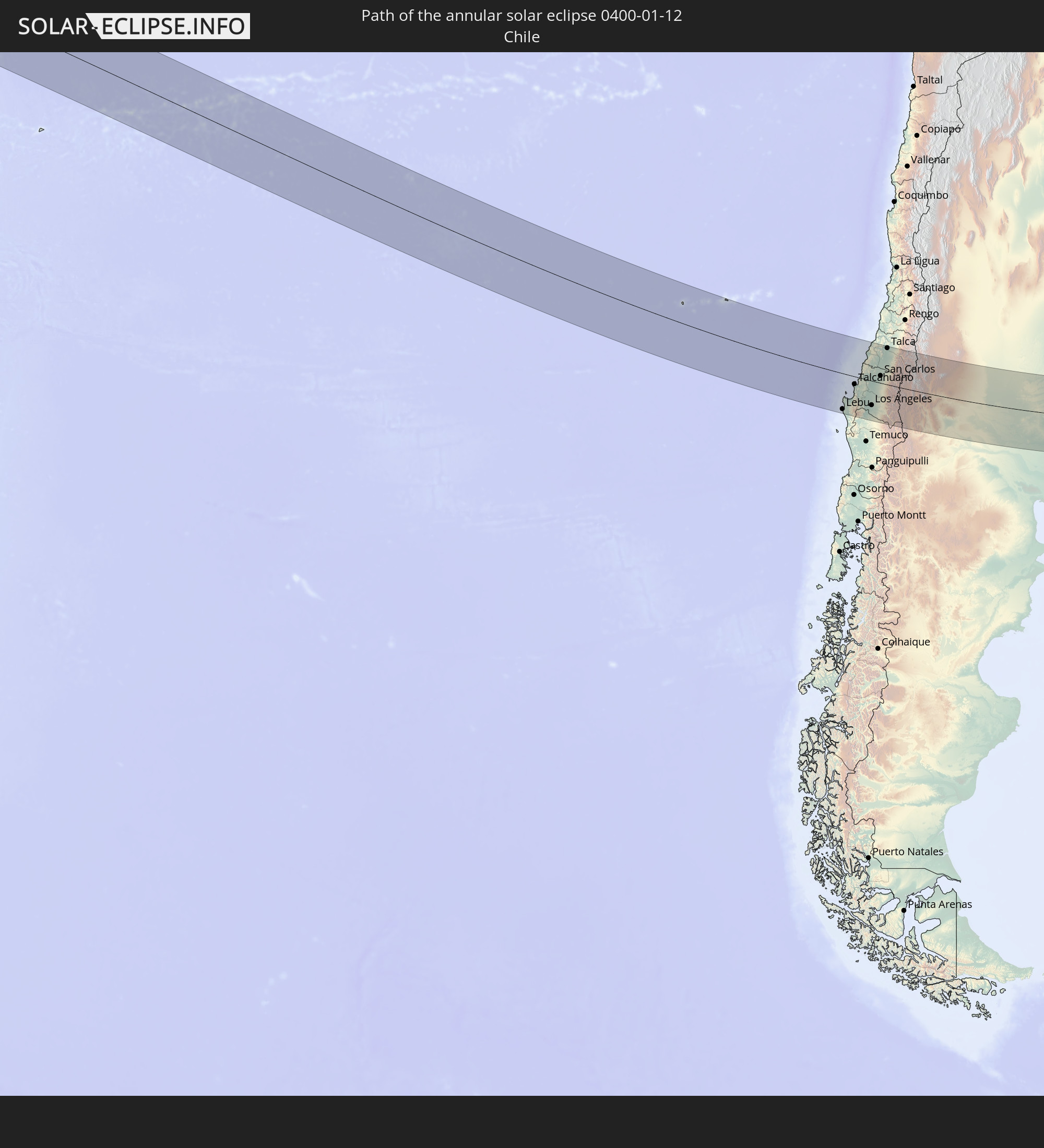 Chile
Chile
 Argentina
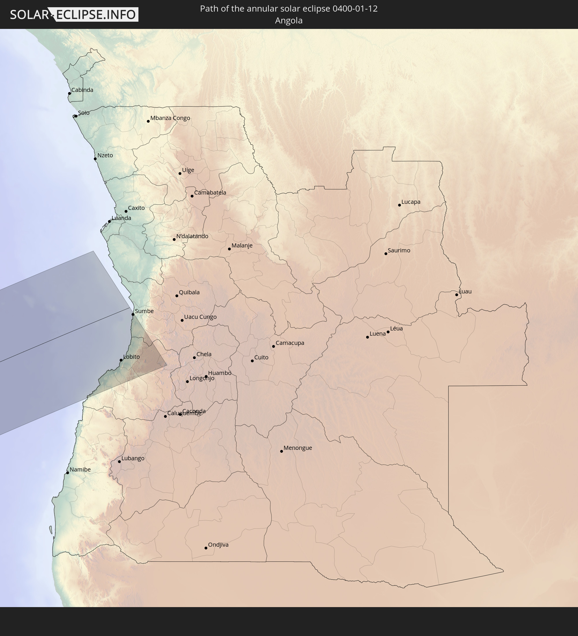 Angola
In den folgenden Ländern ist die Sonnenfinsternis partiell zu sehen
 Antarctica
 Pitcairn Islands
 Chile
Chile
 Ecuador
 Colombia
 Peru
Peru
 Brazil
 Argentina
 Bolivia
 Paraguay
 Falkland Islands
 Uruguay
 South Georgia and the South Sandwich Islands
 Senegal
 Mauritania
 The Gambia
 Guinea-Bissau
 Guinea
 Saint Helena, Ascension and Tristan da Cunha
 Sierra Leone
 Mali
Mali
 Liberia
 Ivory Coast
 Burkina Faso
 Ghana
Ghana
 Togo
Togo
 Niger
Niger
 Benin
Benin
 Nigeria
 Bouvet Island
 Equatorial Guinea
 São Tomé and Príncipe
 Angola
 Namibia
 South Africa
 Botswana
 Lesotho
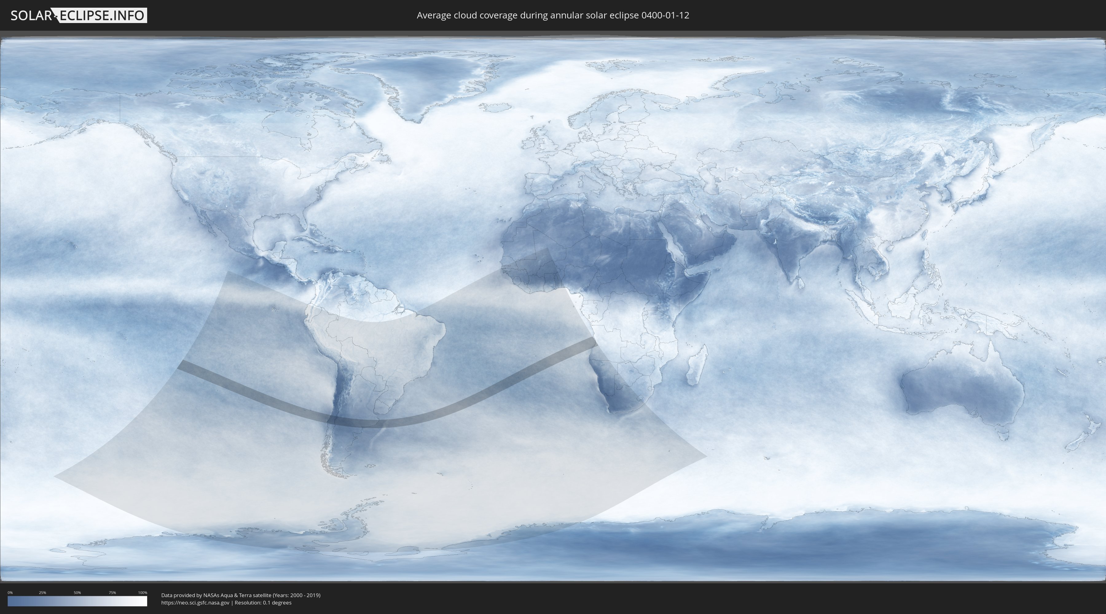
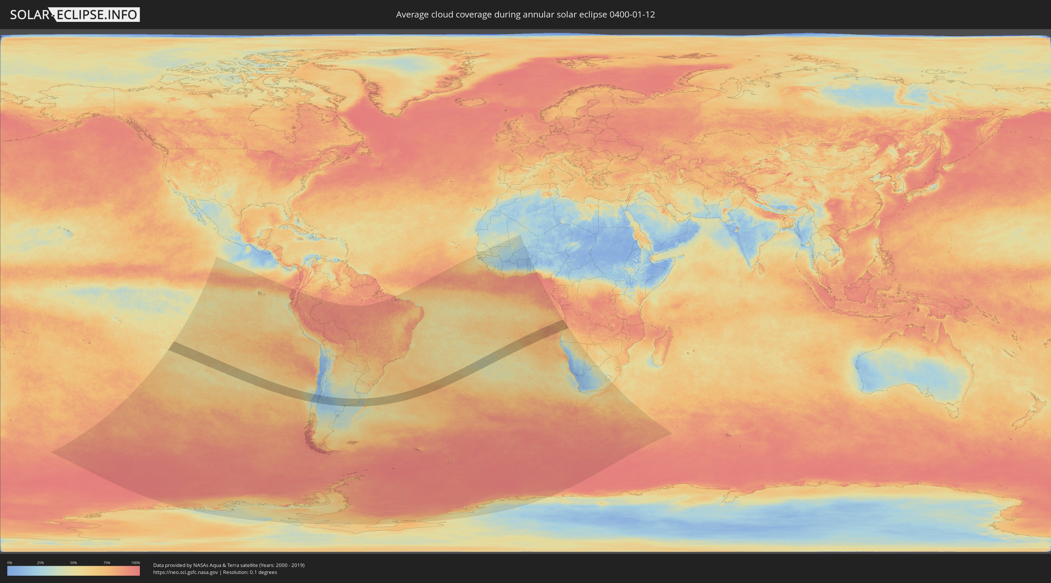
How will be the weather during the annular solar eclipse on 01/12/0400?
Where is the best place to see the annular solar eclipse of 01/12/0400?
The following maps show the average cloud coverage for the day of the annular solar eclipse.
With the help of these maps, it is possible to find the place along the eclipse path, which has the best
chance of a cloudless sky.
Nevertheless, you should consider local circumstances and inform about the weather of your chosen
observation site.
The data is provided by NASAs satellites
AQUA and TERRA.
The cloud maps are averaged over a period of 19 years (2000 - 2019).
Detailed country maps
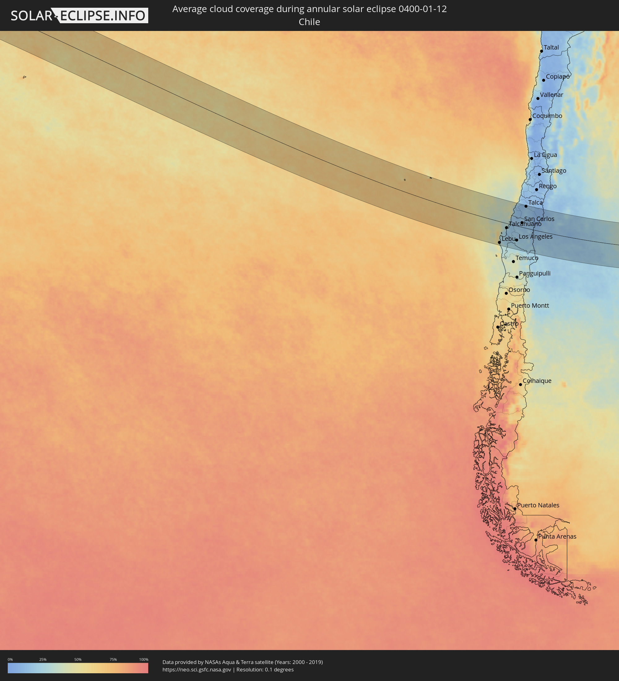 Chile
Chile
 Argentina
 Angola
Cities inside the path of the eclipse
The following table shows all locations with a population of more than 5,000 inside the eclipse path. Cities which have more than 100,000 inhabitants are marked bold. A click at the locations opens a detailed map.
| City | Type | Eclipse duration | Local time of max. eclipse | Distance to central line | Ø Cloud coverage |
|
Lebu, Biobío
|
annular | - | 10:01:37 UTC-04:42 | 137 km | 47% |
|
Cañete, Biobío
|
annular | - | 10:02:21 UTC-04:42 | 152 km | 31% |
|
Curanilahue, Biobío
|
annular | - | 10:02:05 UTC-04:42 | 116 km | 25% |
|
Arauco, Biobío
|
annular | - | 10:01:52 UTC-04:42 | 90 km | 25% |
|
Lota, Biobío
|
annular | - | 10:02:01 UTC-04:42 | 70 km | 23% |
|
Coronel, Biobío
|
annular | - | 10:01:59 UTC-04:42 | 63 km | 18% |
|
Talcahuano, Biobío
|
annular | - | 10:01:40 UTC-04:42 | 30 km | 25% |
|
Concepción, Biobío
|
annular | - | 10:01:56 UTC-04:42 | 39 km | 21% |
|
Chiguayante, Biobío
|
annular | - | 10:02:05 UTC-04:42 | 49 km | 17% |
|
Penco, Biobío
|
annular | - | 10:01:56 UTC-04:42 | 29 km | 25% |
|
Tomé, Biobío
|
annular | - | 10:01:53 UTC-04:42 | 15 km | 27% |
|
Angol, Araucanía
|
annular | - | 10:03:42 UTC-04:42 | 136 km | 27% |
|
La Laja, Biobío
|
annular | - | 10:03:08 UTC-04:42 | 81 km | 19% |
|
Nacimiento, Biobío
|
annular | - | 10:03:28 UTC-04:42 | 104 km | 21% |
|
Yumbel, Biobío
|
annular | - | 10:03:14 UTC-04:42 | 58 km | 19% |
|
Collipulli, Araucanía
|
annular | - | 10:04:27 UTC-04:42 | 148 km | 29% |
|
Constitución, Maule
|
annular | - | 10:01:34 UTC-04:42 | 136 km | 23% |
|
Cabrero, Biobío
|
annular | - | 10:03:29 UTC-04:42 | 48 km | 19% |
|
Los Ángeles, Biobío
|
annular | - | 10:04:05 UTC-04:42 | 94 km | 24% |
|
Cauquenes, Maule
|
annular | - | 10:02:28 UTC-04:42 | 70 km | 13% |
|
Bulnes, Biobío
|
annular | - | 10:03:23 UTC-04:42 | 14 km | 21% |
|
Mulchén, Biobío
|
annular | - | 10:04:35 UTC-04:42 | 118 km | 26% |
|
Chillán, Biobío
|
annular | - | 10:03:38 UTC-04:42 | 5 km | 17% |
|
San Carlos, Biobío
|
annular | - | 10:03:45 UTC-04:42 | 28 km | 18% |
|
Coihueco, Biobío
|
annular | - | 10:04:14 UTC-04:42 | 8 km | 14% |
|
Parral, Maule
|
annular | - | 10:03:43 UTC-04:42 | 61 km | 17% |
|
San Javier, Maule
|
annular | - | 10:03:20 UTC-04:42 | 122 km | 16% |
|
Longaví, Maule
|
annular | - | 10:03:50 UTC-04:42 | 83 km | 17% |
|
Talca, Maule
|
annular | - | 10:03:18 UTC-04:42 | 142 km | 14% |
|
Linares, Maule
|
annular | - | 10:03:54 UTC-04:42 | 98 km | 18% |
|
San Clemente, Maule
|
annular | - | 10:03:48 UTC-04:42 | 134 km | 17% |
|
Chos Malal, Neuquén Province
|
annular | - | 10:34:21 UTC-04:16 | 42 km | 16% |
|
Catriel, Río Negro Province
|
annular | - | 10:40:23 UTC-04:16 | 56 km | 18% |
|
Veinticinco de Mayo, La Pampa Province
|
annular | - | 10:40:28 UTC-04:16 | 43 km | 20% |
|
General Acha, La Pampa Province
|
annular | - | 10:47:38 UTC-04:16 | 40 km | 34% |
|
Santa Rosa, La Pampa Province
|
annular | - | 10:47:57 UTC-04:16 | 128 km | 35% |
|
Guatraché, La Pampa Province
|
annular | - | 10:50:31 UTC-04:16 | 19 km | 34% |
|
Bahía Blanca, Buenos Aires
|
annular | - | 10:54:15 UTC-04:16 | 88 km | 40% |
|
Punta Alta, Buenos Aires
|
annular | - | 10:54:50 UTC-04:16 | 104 km | 39% |
|
Coronel Suárez, Buenos Aires
|
annular | - | 10:54:30 UTC-04:16 | 54 km | 37% |
|
Coronel Dorrego, Buenos Aires
|
annular | - | 10:56:44 UTC-04:16 | 82 km | 40% |
|
Olavarría, Buenos Aires
|
annular | - | 10:58:33 UTC-04:16 | 125 km | 42% |
|
Tres Arroyos, Buenos Aires
|
annular | - | 10:59:11 UTC-04:16 | 40 km | 43% |
|
Azul, Buenos Aires
|
annular | - | 10:59:47 UTC-04:16 | 139 km | 44% |
|
Tandil, Buenos Aires
|
annular | - | 11:01:54 UTC-04:16 | 80 km | 44% |
|
Necochea, Buenos Aires
|
annular | - | 11:03:15 UTC-04:16 | 56 km | 43% |
|
Mar del Plata, Buenos Aires
|
annular | - | 11:06:17 UTC-04:16 | 5 km | 49% |
|
Villa Gesell, Buenos Aires
|
annular | - | 11:07:49 UTC-04:16 | 87 km | 45% |
|
Benguela, Benguela Province
|
annular | - | 17:47:43 UTC+00:13 | 146 km | 68% |
|
Lobito, Benguela Province
|
annular | - | 17:47:51 UTC+00:13 | 129 km | 77% |
|
Catumbela, Benguela Province
|
annular | - | 17:47:48 UTC+00:13 | 137 km | 77% |
|
Sumbe, Kwanza Sul
|
annular | - | 17:48:42 UTC+00:13 | 23 km | 78% |