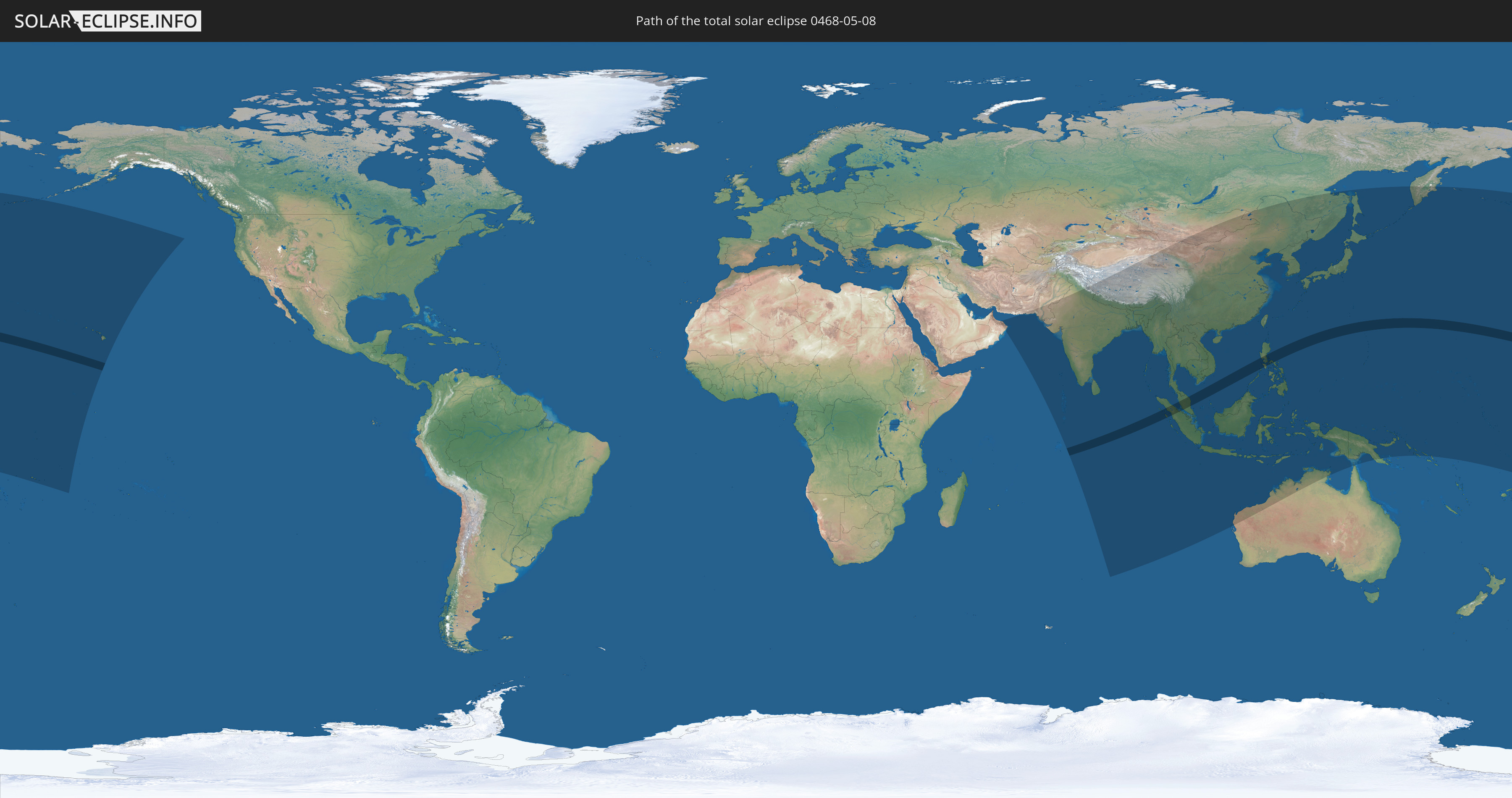
Total solar eclipse of 05/08/0468
| Day of week: | Tuesday |
| Maximum duration of eclipse: | 06m56s |
| Maximum width of eclipse path: | 255 km |
| Saros cycle: | 84 |
| Coverage: | 100% |
| Magnitude: | 1.0789 |
| Gamma: | 0.0474 |
Wo kann man die Sonnenfinsternis vom 05/08/0468 sehen?
Die Sonnenfinsternis am 05/08/0468 kann man in 48 Ländern als partielle Sonnenfinsternis beobachten.
Der Finsternispfad verläuft durch 4 Länder. Nur in diesen Ländern ist sie als total Sonnenfinsternis zu sehen.
In den folgenden Ländern ist die Sonnenfinsternis total zu sehen
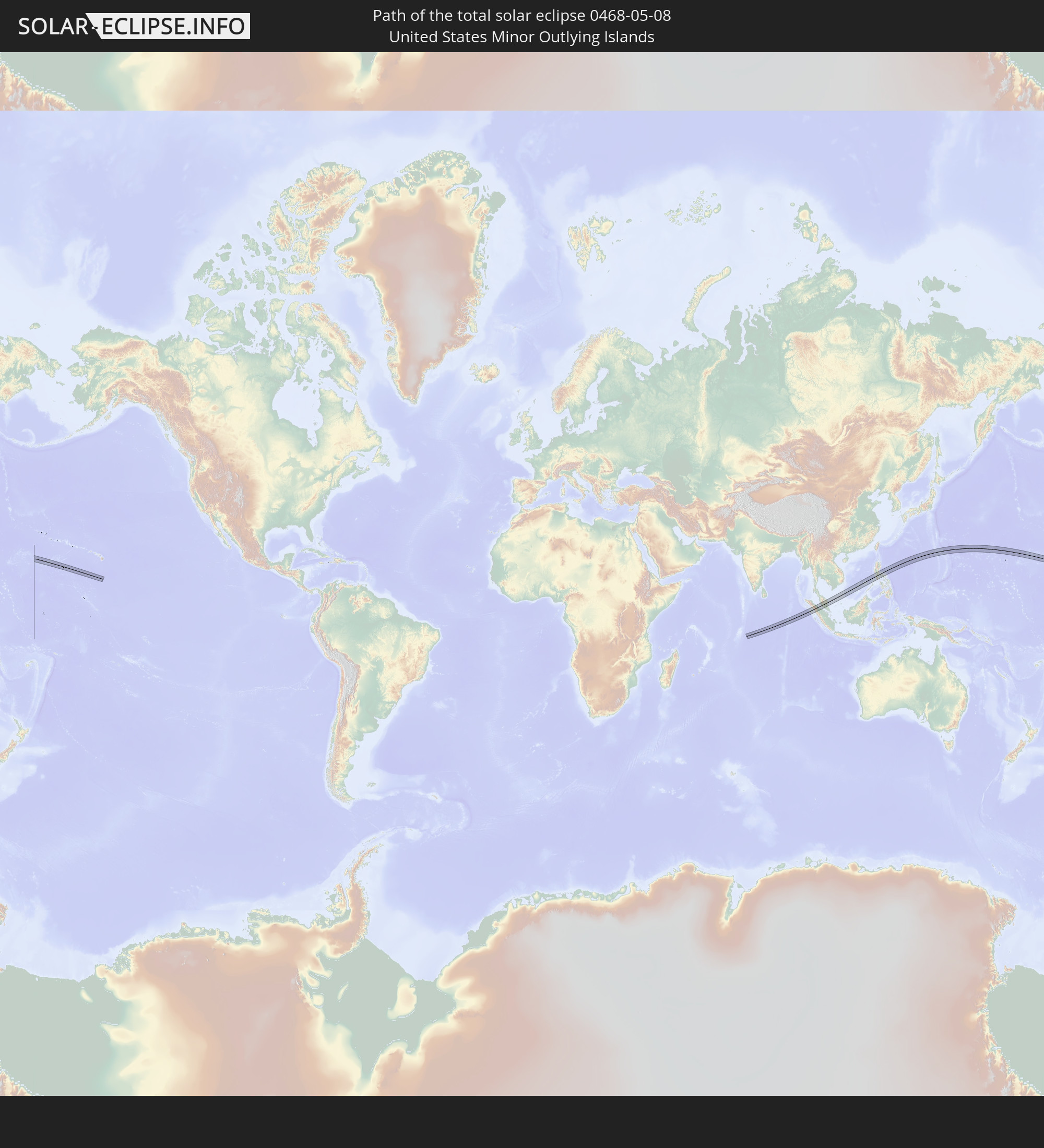 United States Minor Outlying Islands
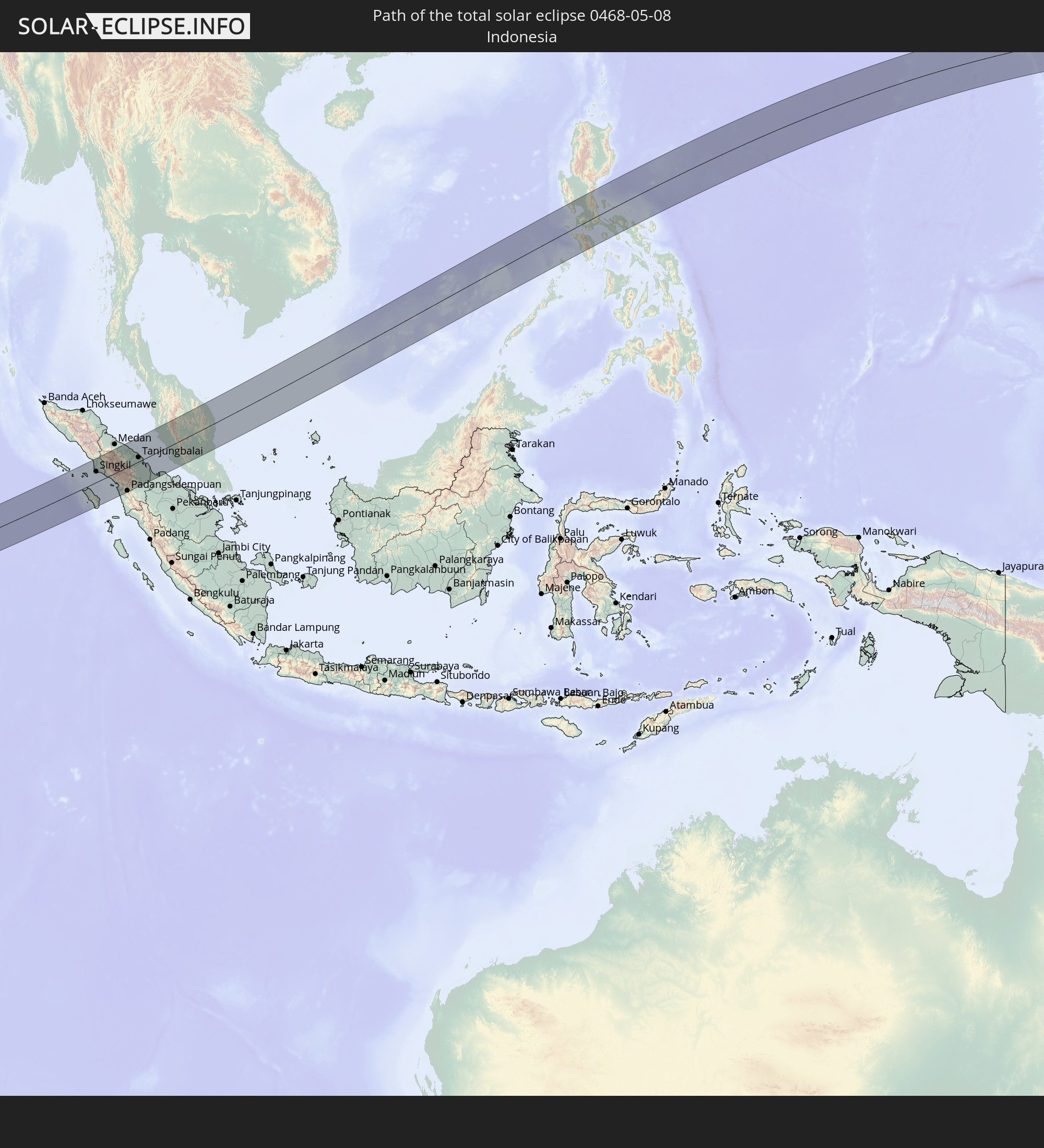 Indonesia
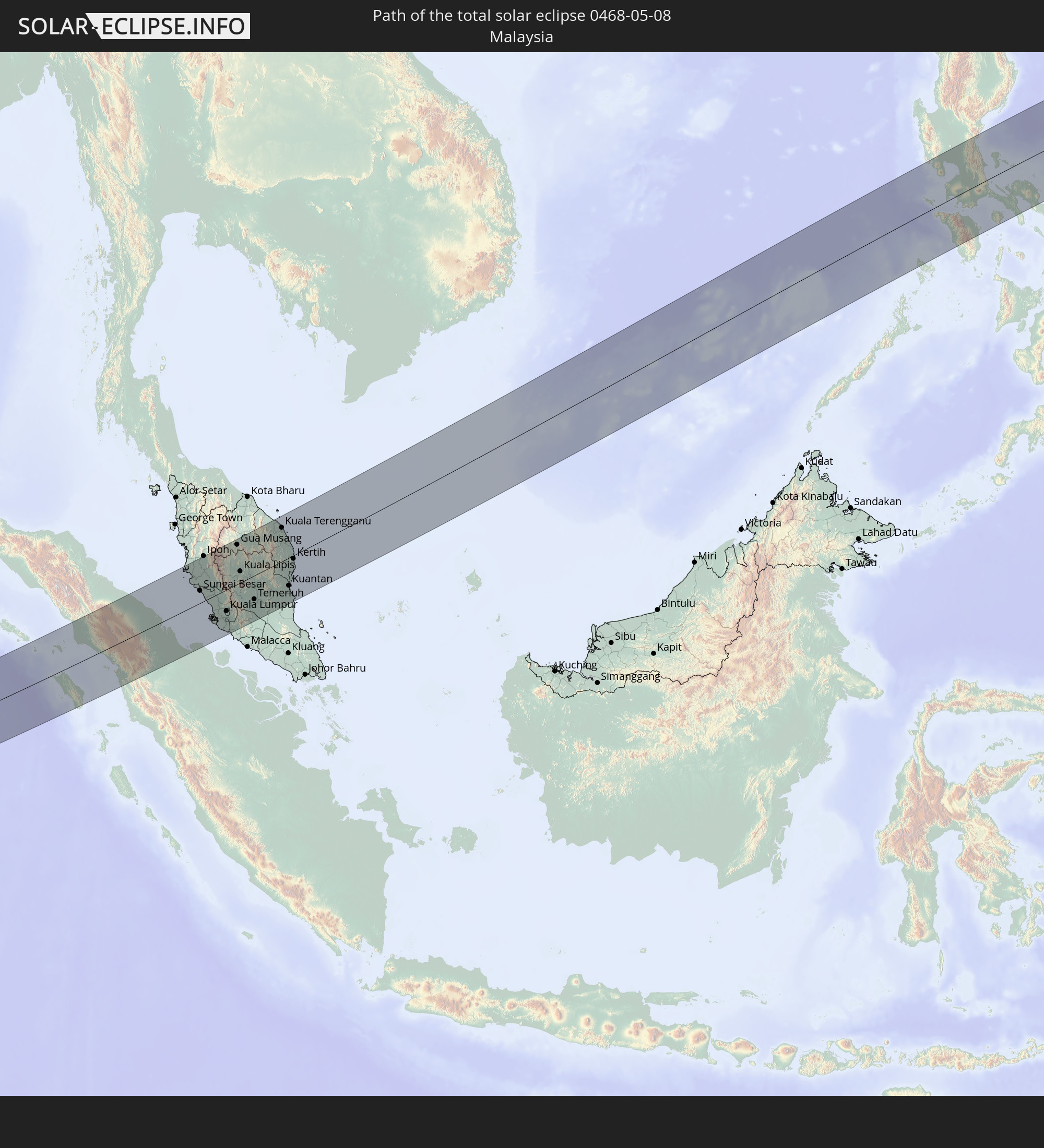 Malaysia
 Philippines
In den folgenden Ländern ist die Sonnenfinsternis partiell zu sehen
 Russia
 United States
 United States Minor Outlying Islands
 Wallis and Futuna
 Kiribati
 Samoa
Samoa
 Tokelau
 American Samoa
 Cook Islands
 Oman
Oman
 Pakistan
 India
India
 Maldives
 China
China
 Sri Lanka
 Nepal
Nepal
 Mongolia
 Bangladesh
 Bhutan
 Myanmar
 Indonesia
 Cocos Islands
 Thailand
 Malaysia
 Laos
Laos
 Vietnam
 Cambodia
 Singapore
 Christmas Island
 Australia
 Macau
Macau
 Hong Kong
 Brunei
 Taiwan
 Philippines
 Japan
Japan
 East Timor
 North Korea
 South Korea
 Palau
Palau
 Federated States of Micronesia
 Papua New Guinea
 Guam
Guam
 Northern Mariana Islands
 Solomon Islands
 Marshall Islands
 Nauru
Nauru
 Tuvalu
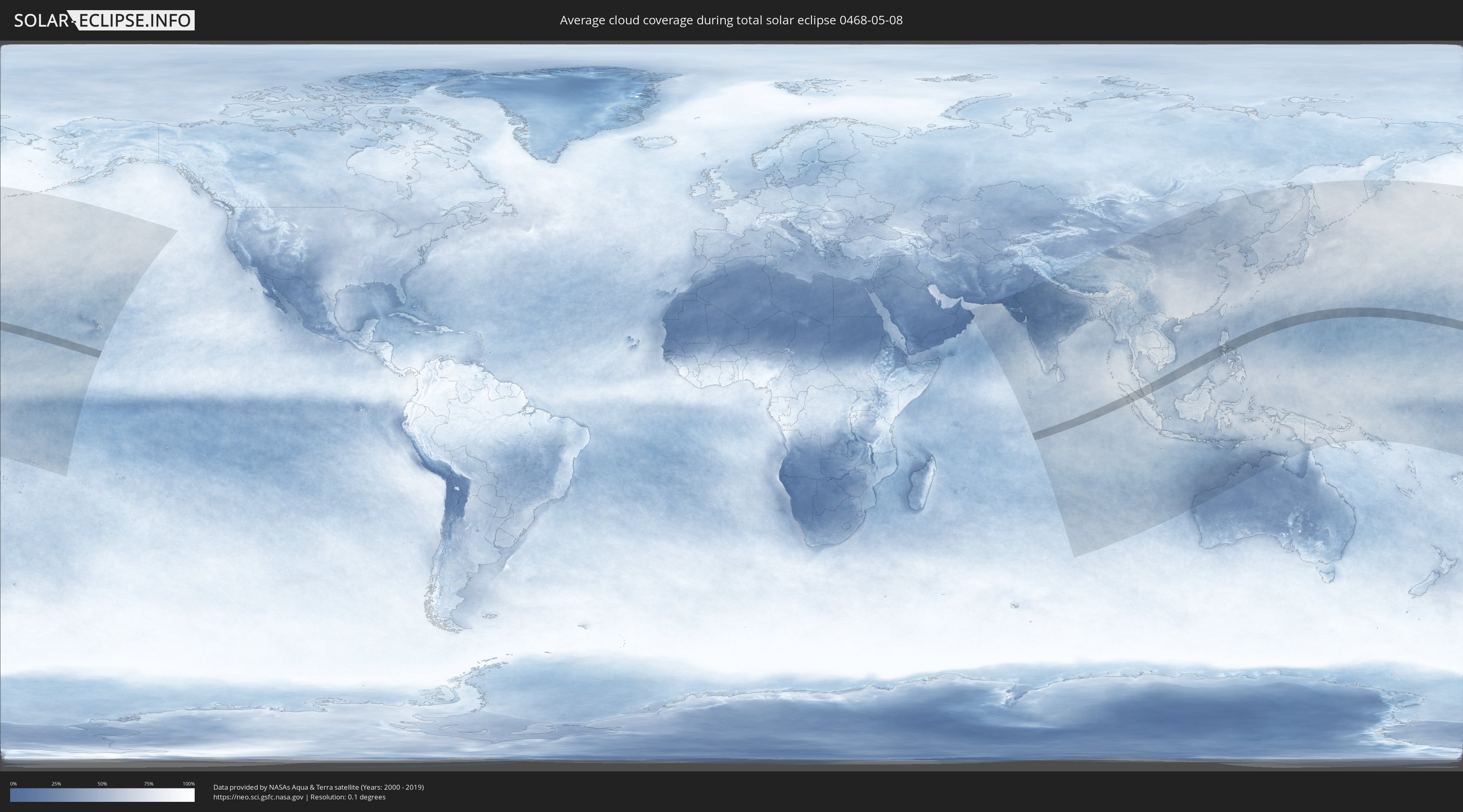
How will be the weather during the total solar eclipse on 05/08/0468?
Where is the best place to see the total solar eclipse of 05/08/0468?
The following maps show the average cloud coverage for the day of the total solar eclipse.
With the help of these maps, it is possible to find the place along the eclipse path, which has the best
chance of a cloudless sky.
Nevertheless, you should consider local circumstances and inform about the weather of your chosen
observation site.
The data is provided by NASAs satellites
AQUA and TERRA.
The cloud maps are averaged over a period of 19 years (2000 - 2019).
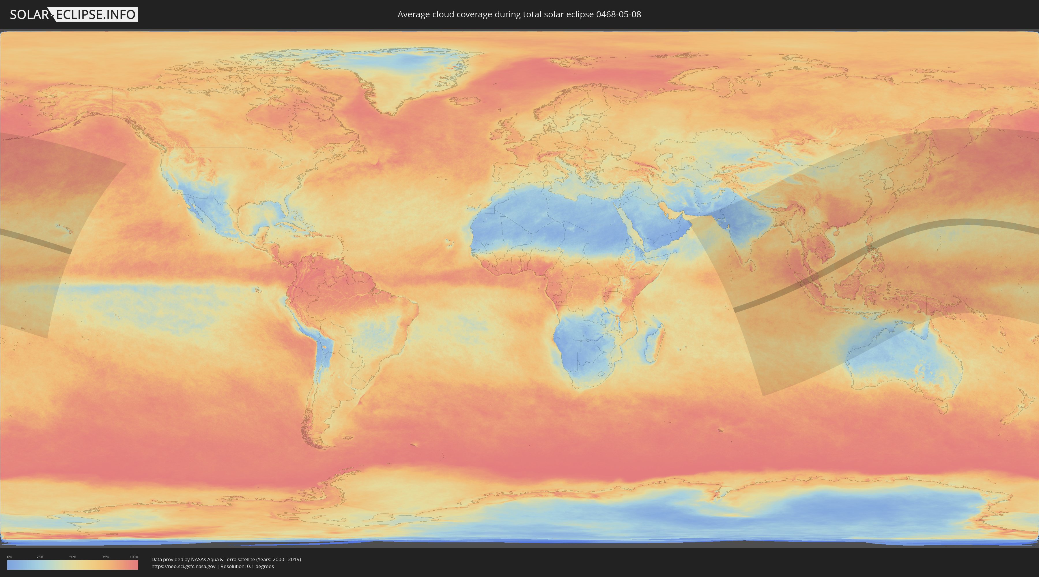
Detailed country maps
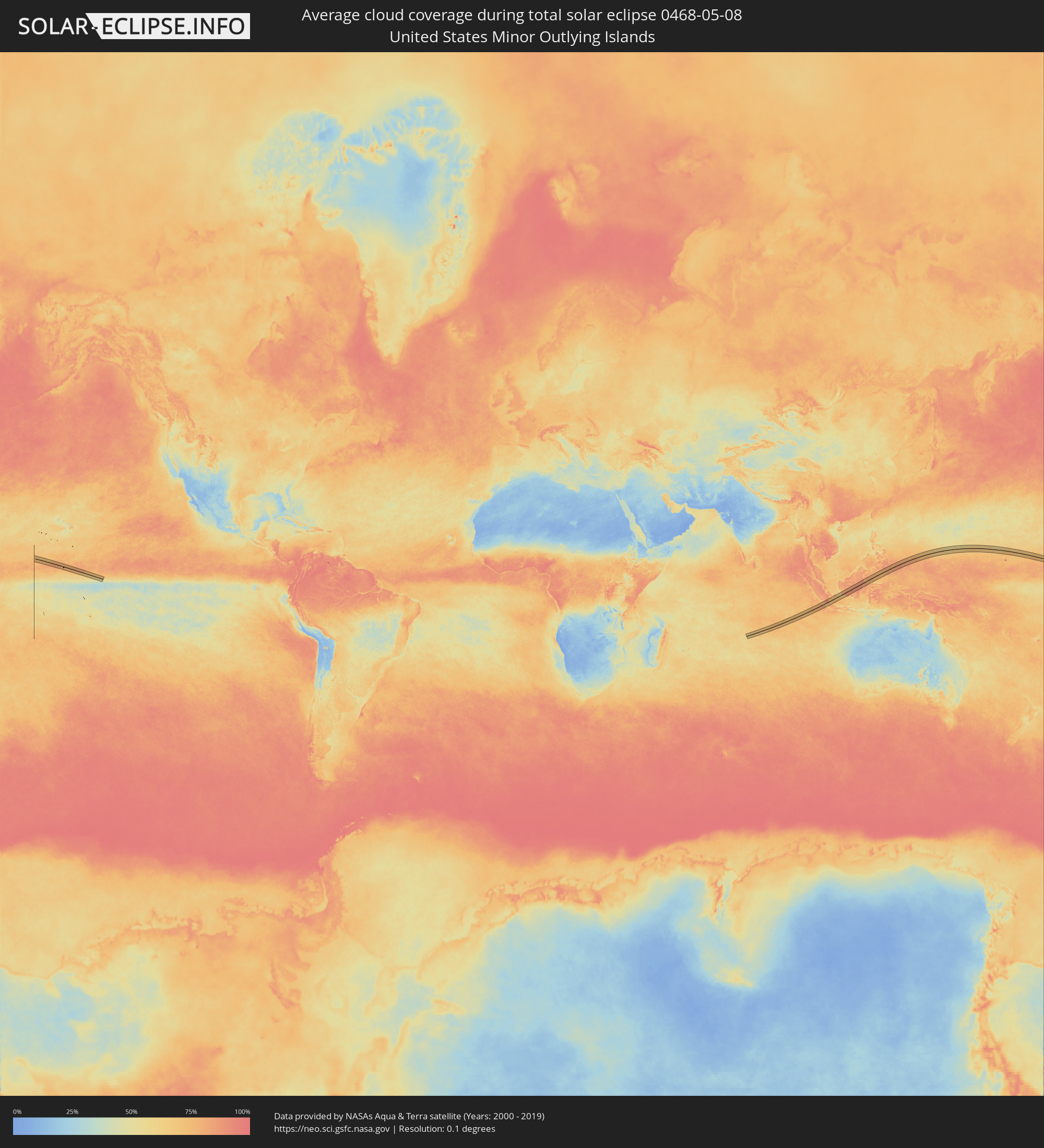 United States Minor Outlying Islands
 Indonesia
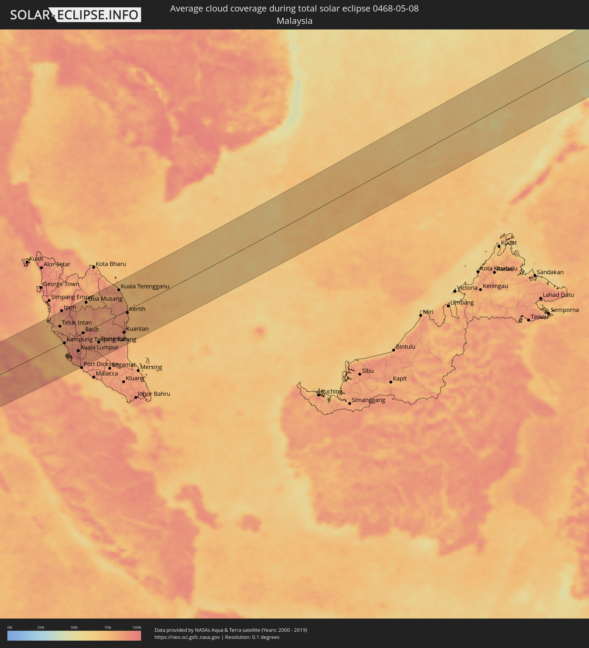 Malaysia
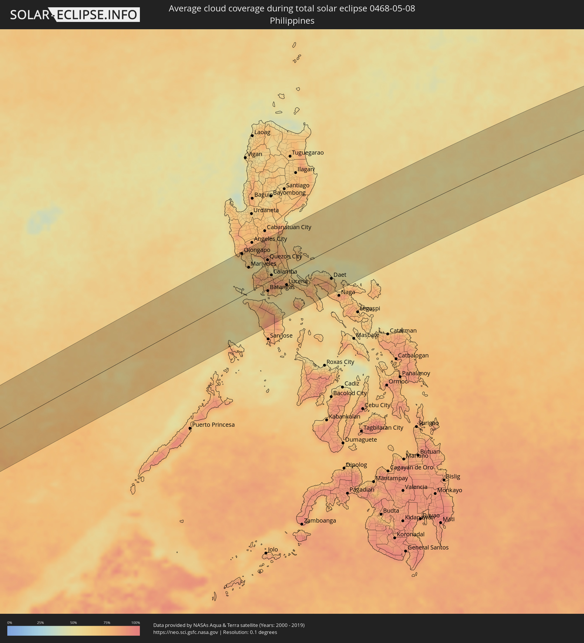 Philippines
Cities inside the path of the eclipse
The following table shows all locations with a population of more than 5,000 inside the eclipse path. Cities which have more than 100,000 inhabitants are marked bold. A click at the locations opens a detailed map.
| City | Type | Eclipse duration | Local time of max. eclipse | Distance to central line | Ø Cloud coverage |
|
Singkil, Aceh
|
total | - | 08:26:09 UTC+07:07 | 51 km | 77% |
|
Kabanjahe, North Sumatra
|
total | - | 08:27:24 UTC+07:07 | 98 km | 87% |
|
Berastagi, North Sumatra
|
total | - | 08:27:30 UTC+07:07 | 107 km | 88% |
|
Tongging, North Sumatra
|
total | - | 08:27:15 UTC+07:07 | 76 km | 88% |
|
Sibolga, North Sumatra
|
total | - | 08:26:29 UTC+07:07 | 52 km | 82% |
|
Pematangsiantar, North Sumatra
|
total | - | 08:27:45 UTC+07:07 | 56 km | 90% |
|
Tebingtinggi, North Sumatra
|
total | - | 08:28:09 UTC+07:07 | 88 km | 90% |
|
Pekan Bahapal, North Sumatra
|
total | - | 08:27:58 UTC+07:07 | 66 km | 89% |
|
Padangsidempuan, North Sumatra
|
total | - | 08:26:35 UTC+07:07 | 112 km | 89% |
|
Kisaran, North Sumatra
|
total | - | 08:28:14 UTC+07:07 | 31 km | 91% |
|
Bandar, North Sumatra
|
total | - | 08:27:33 UTC+07:07 | 69 km | 89% |
|
Tanjungbalai, North Sumatra
|
total | - | 08:28:23 UTC+07:07 | 21 km | 88% |
|
Teluk Nibung, North Sumatra
|
total | - | 08:28:26 UTC+07:07 | 23 km | 88% |
|
Rantauprapat, North Sumatra
|
total | - | 08:27:40 UTC+07:07 | 68 km | 89% |
|
Lumut, Perak
|
total | - | 08:18:30 UTC+06:55 | 105 km | 77% |
|
Sungai Besar, Selangor
|
total | - | 08:18:19 UTC+06:55 | 32 km | 79% |
|
Sabak Bernam, Selangor
|
total | - | 08:18:24 UTC+06:55 | 42 km | 83% |
|
Teluk Intan, Perak
|
total | - | 08:18:40 UTC+06:55 | 65 km | 82% |
|
Batu Gajah, Perak
|
total | - | 08:19:06 UTC+06:55 | 108 km | 81% |
|
Ipoh, Perak
|
total | - | 08:19:15 UTC+06:55 | 118 km | 90% |
|
Kampar, Perak
|
total | - | 08:19:03 UTC+06:55 | 86 km | 81% |
|
Kampung Tanjung Karang, Selangor
|
total | - | 08:18:16 UTC+06:55 | 3 km | 79% |
|
Tapah Road, Perak
|
total | - | 08:18:58 UTC+06:55 | 70 km | 82% |
|
Kuala Selangor, Selangor
|
total | - | 08:18:16 UTC+06:55 | 13 km | 85% |
|
Bidur, Perak
|
total | - | 08:19:00 UTC+06:55 | 61 km | 83% |
|
Kampong Dungun, Perak
|
total | - | 08:18:12 UTC+06:55 | 30 km | 76% |
|
Tanah Rata, Pahang
|
total | - | 08:19:25 UTC+06:55 | 91 km | 93% |
|
Batang Berjuntai, Selangor
|
total | - | 08:18:27 UTC+06:55 | 18 km | 90% |
|
Klang, Selangor
|
total | - | 08:18:10 UTC+06:55 | 55 km | 91% |
|
Batu Arang, Selangor
|
total | - | 08:18:26 UTC+06:55 | 27 km | 92% |
|
Jenjarum, Selangor
|
total | - | 08:18:04 UTC+06:55 | 73 km | 87% |
|
Banting, Selangor
|
total | - | 08:18:01 UTC+06:55 | 79 km | 83% |
|
Ladang Seri Kundang, Selangor
|
total | - | 08:18:27 UTC+06:55 | 33 km | 92% |
|
Shah Alam, Selangor
|
total | - | 08:18:17 UTC+06:55 | 54 km | 94% |
|
Kampung Baru Subang, Selangor
|
total | - | 08:18:21 UTC+06:55 | 47 km | 94% |
|
Kuang, Selangor
|
total | - | 08:18:28 UTC+06:55 | 38 km | 92% |
|
Tanjung Sepat, Selangor
|
total | - | 08:17:56 UTC+06:55 | 98 km | 79% |
|
Putra Heights, Selangor
|
total | - | 08:18:15 UTC+06:55 | 65 km | 92% |
|
Rawang, Selangor
|
total | - | 08:18:33 UTC+06:55 | 32 km | 92% |
|
Subang Jaya, Selangor
|
total | - | 08:18:18 UTC+06:55 | 60 km | 92% |
|
Serendah, Selangor
|
total | - | 08:18:37 UTC+06:55 | 30 km | 90% |
|
Petaling Jaya, Selangor
|
total | - | 08:18:23 UTC+06:55 | 55 km | 93% |
|
Kuala Lumpur, Kuala Lumpur
|
total | - | 08:18:29 UTC+06:55 | 56 km | 93% |
|
Putrajaya, Putrajaya
|
total | - | 08:18:18 UTC+06:55 | 77 km | 90% |
|
Sungai Pelek New Village
|
total | - | 08:18:04 UTC+06:55 | 105 km | 82% |
|
Sepang, Selangor
|
total | - | 08:18:09 UTC+06:55 | 104 km | 82% |
|
Kampong Baharu Balakong, Selangor
|
total | - | 08:18:27 UTC+06:55 | 70 km | 94% |
|
Kampung Baharu Nilai, Negeri Sembilan
|
total | - | 08:18:17 UTC+06:55 | 95 km | 88% |
|
Kampung Bukit Tinggi, Bentong, Pahang
|
total | - | 08:18:49 UTC+06:55 | 42 km | 87% |
|
Semenyih, Selangor
|
total | - | 08:18:28 UTC+06:55 | 83 km | 94% |
|
Raub, Pahang
|
total | - | 08:19:15 UTC+06:55 | 0 km | 86% |
|
Bentong Town, Pahang
|
total | - | 08:19:03 UTC+06:55 | 29 km | 89% |
|
Seremban, Negeri Sembilan
|
total | - | 08:18:22 UTC+06:55 | 109 km | 88% |
|
Gua Musang, Kelantan
|
total | - | 08:20:23 UTC+06:55 | 103 km | 82% |
|
Kuala Lipis, Pahang
|
total | - | 08:19:48 UTC+06:55 | 30 km | 83% |
|
Mentekab, Pahang
|
total | - | 08:19:27 UTC+06:55 | 55 km | 86% |
|
Jerantut, Pahang
|
total | - | 08:19:53 UTC+06:55 | 11 km | 82% |
|
Temerluh, Pahang
|
total | - | 08:19:29 UTC+06:55 | 62 km | 85% |
|
Kuala Terengganu, Terengganu
|
total | - | 08:22:02 UTC+06:55 | 88 km | 86% |
|
Marang, Terengganu
|
total | - | 08:21:59 UTC+06:55 | 72 km | 82% |
|
Kuantan, Pahang
|
total | - | 08:20:45 UTC+06:55 | 73 km | 86% |
|
Pekan, Pahang
|
total | - | 08:20:31 UTC+06:55 | 108 km | 83% |
|
Cukai, Terengganu
|
total | - | 08:21:16 UTC+06:55 | 33 km | 84% |
|
Paka, Terengganu
|
total | - | 08:21:40 UTC+06:55 | 4 km | 85% |
|
Kertih, Terengganu
|
total | - | 08:21:34 UTC+06:55 | 9 km | 84% |
|
Morong, Central Luzon
|
total | - | 10:04:34 UTC+08:00 | 106 km | 60% |
|
Olongapo, Central Luzon
|
total | - | 10:04:48 UTC+08:00 | 120 km | 63% |
|
Dinalupihan, Central Luzon
|
total | - | 10:05:13 UTC+08:00 | 116 km | 67% |
|
Mariveles, Central Luzon
|
total | - | 10:04:42 UTC+08:00 | 71 km | 52% |
|
Balanga, Central Luzon
|
total | - | 10:05:08 UTC+08:00 | 92 km | 63% |
|
Mamburao, Mimaropa
|
total | - | 10:03:21 UTC+08:00 | 54 km | 59% |
|
Nasugbu, Calabarzon
|
total | - | 10:04:32 UTC+08:00 | 27 km | 74% |
|
Calatagan, Calabarzon
|
total | - | 10:04:13 UTC+08:00 | 4 km | 51% |
|
Lian, Calabarzon
|
total | - | 10:04:31 UTC+08:00 | 23 km | 65% |
|
Lumbangan, Calabarzon
|
total | - | 10:04:35 UTC+08:00 | 24 km | 83% |
|
San Fernando, Central Luzon
|
total | - | 10:05:55 UTC+08:00 | 119 km | 75% |
|
Santa Cruz, Mimaropa
|
total | - | 10:03:25 UTC+08:00 | 75 km | 63% |
|
Balayan, Calabarzon
|
total | - | 10:04:34 UTC+08:00 | 9 km | 60% |
|
Naic, Calabarzon
|
total | - | 10:05:09 UTC+08:00 | 45 km | 79% |
|
Sablayan, Mimaropa
|
total | - | 10:03:12 UTC+08:00 | 101 km | 69% |
|
San Jose, Central Luzon
|
total | - | 10:06:08 UTC+08:00 | 115 km | 82% |
|
General Emilio Aguinaldo, Calabarzon
|
total | - | 10:05:02 UTC+08:00 | 30 km | 81% |
|
Malolos, Central Luzon
|
total | - | 10:05:56 UTC+08:00 | 95 km | 70% |
|
Candaba, Central Luzon
|
total | - | 10:06:18 UTC+08:00 | 118 km | 75% |
|
Pasong Kawayan Primero, Calabarzon
|
total | - | 10:05:25 UTC+08:00 | 42 km | 77% |
|
Ligaya, Mimaropa
|
total | - | 10:03:14 UTC+08:00 | 124 km | 71% |
|
Baliuag, Central Luzon
|
total | - | 10:06:16 UTC+08:00 | 101 km | 84% |
|
Cavite City, Calabarzon
|
total | - | 10:05:39 UTC+08:00 | 55 km | 65% |
|
Taal, Calabarzon
|
total | - | 10:04:54 UTC+08:00 | 6 km | 70% |
|
Dasmariñas, Calabarzon
|
total | - | 10:05:31 UTC+08:00 | 38 km | 77% |
|
Patuto, Calabarzon
|
total | - | 10:05:18 UTC+08:00 | 15 km | 69% |
|
Camias, Central Luzon
|
total | - | 10:06:42 UTC+08:00 | 118 km | 81% |
|
Balite Segundo, Calabarzon
|
total | - | 10:05:24 UTC+08:00 | 21 km | 79% |
|
San Miguel, Central Luzon
|
total | - | 10:06:41 UTC+08:00 | 116 km | 78% |
|
San Jose del Monte, Central Luzon
|
total | - | 10:06:23 UTC+08:00 | 80 km | 80% |
|
Quezon City, Metro Manila
|
total | - | 10:06:11 UTC+08:00 | 63 km | 71% |
|
Batangas, Calabarzon
|
total | - | 10:05:01 UTC+08:00 | 25 km | 78% |
|
Lipa City, Calabarzon
|
total | - | 10:05:29 UTC+08:00 | 12 km | 82% |
|
Calamba, Calabarzon
|
total | - | 10:05:51 UTC+08:00 | 14 km | 78% |
|
Calapan, Mimaropa
|
total | - | 10:04:50 UTC+08:00 | 65 km | 63% |
|
Binangonan, Calabarzon
|
total | - | 10:06:15 UTC+08:00 | 38 km | 55% |
|
Rodriguez, Calabarzon
|
total | - | 10:06:39 UTC+08:00 | 67 km | 83% |
|
Quilo-quilo, Calabarzon
|
total | - | 10:05:31 UTC+08:00 | 23 km | 82% |
|
Victoria, Mimaropa
|
total | - | 10:04:44 UTC+08:00 | 93 km | 68% |
|
San Pablo, Calabarzon
|
total | - | 10:06:00 UTC+08:00 | 8 km | 85% |
|
Malaya, Calabarzon
|
total | - | 10:06:28 UTC+08:00 | 24 km | 53% |
|
Sampaloc, Calabarzon
|
total | - | 10:06:42 UTC+08:00 | 37 km | 64% |
|
Dingalan, Central Luzon
|
total | - | 10:07:54 UTC+08:00 | 119 km | 62% |
|
Laiya, Calabarzon
|
total | - | 10:05:39 UTC+08:00 | 50 km | 58% |
|
Santa Cruz, Calabarzon
|
total | - | 10:06:29 UTC+08:00 | 9 km | 67% |
|
Candelaria, Calabarzon
|
total | - | 10:06:02 UTC+08:00 | 26 km | 67% |
|
Pinamalayan, Mimaropa
|
total | - | 10:04:57 UTC+08:00 | 115 km | 61% |
|
Mamala, Calabarzon
|
total | - | 10:06:21 UTC+08:00 | 22 km | 79% |
|
Lucban, Calabarzon
|
total | - | 10:06:33 UTC+08:00 | 15 km | 76% |
|
Kalayaan, Calabarzon
|
total | - | 10:06:54 UTC+08:00 | 8 km | 67% |
|
Real, Calabarzon
|
total | - | 10:07:23 UTC+08:00 | 37 km | 69% |
|
Lucena, Calabarzon
|
total | - | 10:06:27 UTC+08:00 | 36 km | 59% |
|
Dinahican, Calabarzon
|
total | - | 10:07:42 UTC+08:00 | 37 km | 61% |
|
Mauban, Calabarzon
|
total | - | 10:07:02 UTC+08:00 | 16 km | 64% |
|
Atimonan, Calabarzon
|
total | - | 10:07:12 UTC+08:00 | 44 km | 67% |
|
Santa Cruz, Mimaropa
|
total | - | 10:06:45 UTC+08:00 | 101 km | 76% |
|
Gumaca, Calabarzon
|
total | - | 10:07:29 UTC+08:00 | 61 km | 75% |
|
General Luna, Calabarzon
|
total | - | 10:07:20 UTC+08:00 | 88 km | 71% |
|
Lopez, Calabarzon
|
total | - | 10:07:48 UTC+08:00 | 73 km | 80% |
|
Catanauan, Calabarzon
|
total | - | 10:07:33 UTC+08:00 | 105 km | 71% |
|
Santa Elena, Bicol
|
total | - | 10:08:26 UTC+08:00 | 51 km | 78% |
|
Tagkawayan Sabang, Calabarzon
|
total | - | 10:08:32 UTC+08:00 | 76 km | 72% |
|
San Narciso, Calabarzon
|
total | - | 10:08:03 UTC+08:00 | 119 km | 59% |
|
Jose Pañganiban, Bicol
|
total | - | 10:09:17 UTC+08:00 | 54 km | 65% |
|
Ragay, Bicol
|
total | - | 10:08:53 UTC+08:00 | 106 km | 70% |
|
Daet, Bicol
|
total | - | 10:09:38 UTC+08:00 | 85 km | 65% |
|
Sipocot, Bicol
|
total | - | 10:09:14 UTC+08:00 | 120 km | 70% |