Total solar eclipse of 05/20/0532
| Day of week: | Tuesday |
| Maximum duration of eclipse: | 02m53s |
| Maximum width of eclipse path: | 210 km |
| Saros cycle: | 75 |
| Coverage: | 100% |
| Magnitude: | 1.033 |
| Gamma: | -0.851 |
Wo kann man die Sonnenfinsternis vom 05/20/0532 sehen?

Die Sonnenfinsternis am 05/20/0532 kann man in 16 Ländern als partielle Sonnenfinsternis beobachten.
Der Finsternispfad verläuft durch 4 Länder. Nur in diesen Ländern ist sie als total Sonnenfinsternis zu sehen.
In den folgenden Ländern ist die Sonnenfinsternis total zu sehen
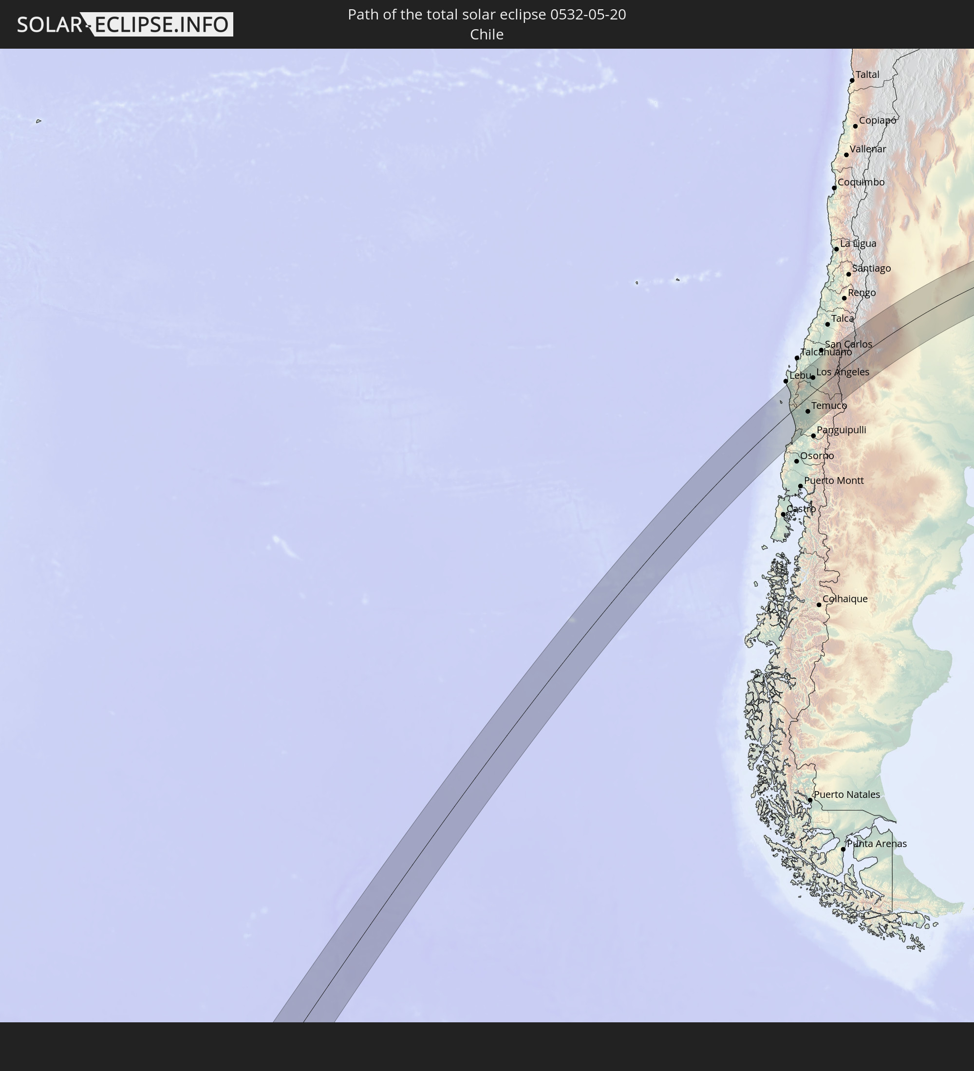 Chile
Chile
 Brazil
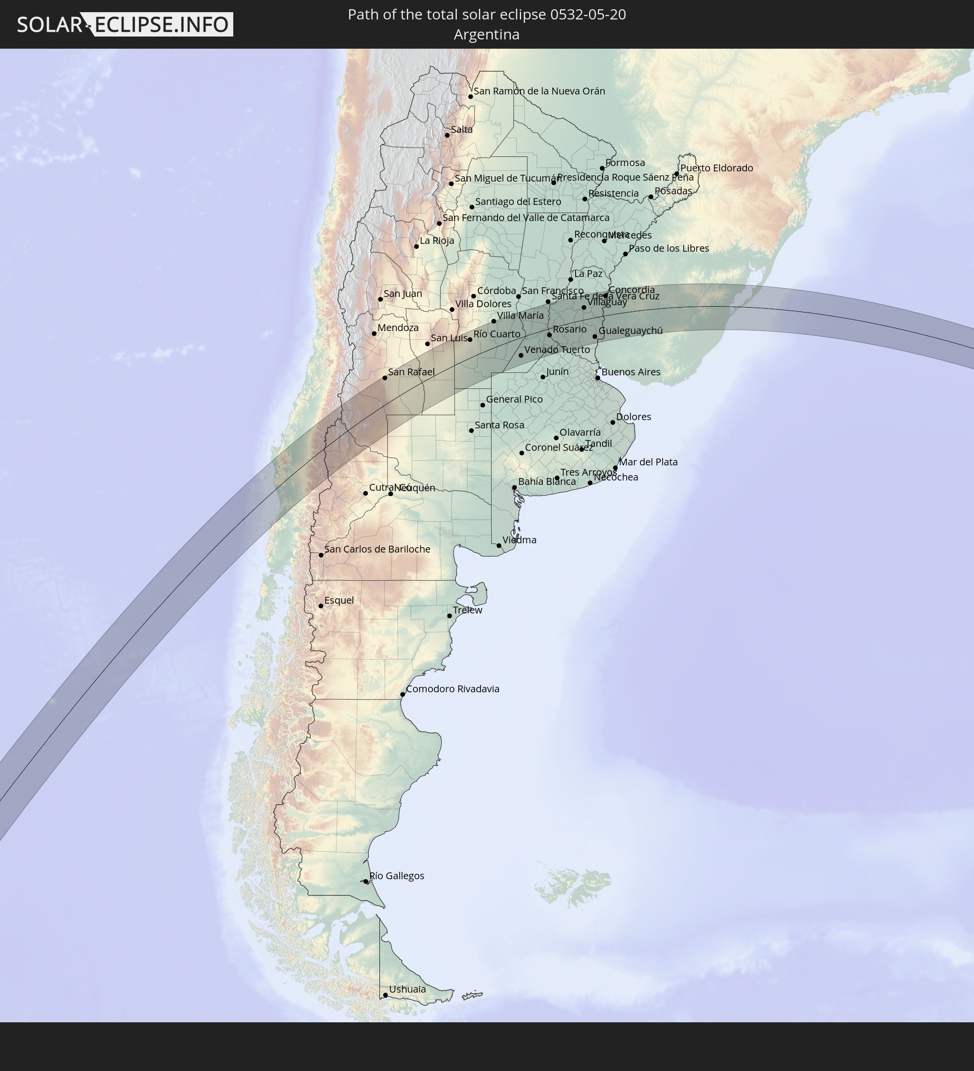 Argentina
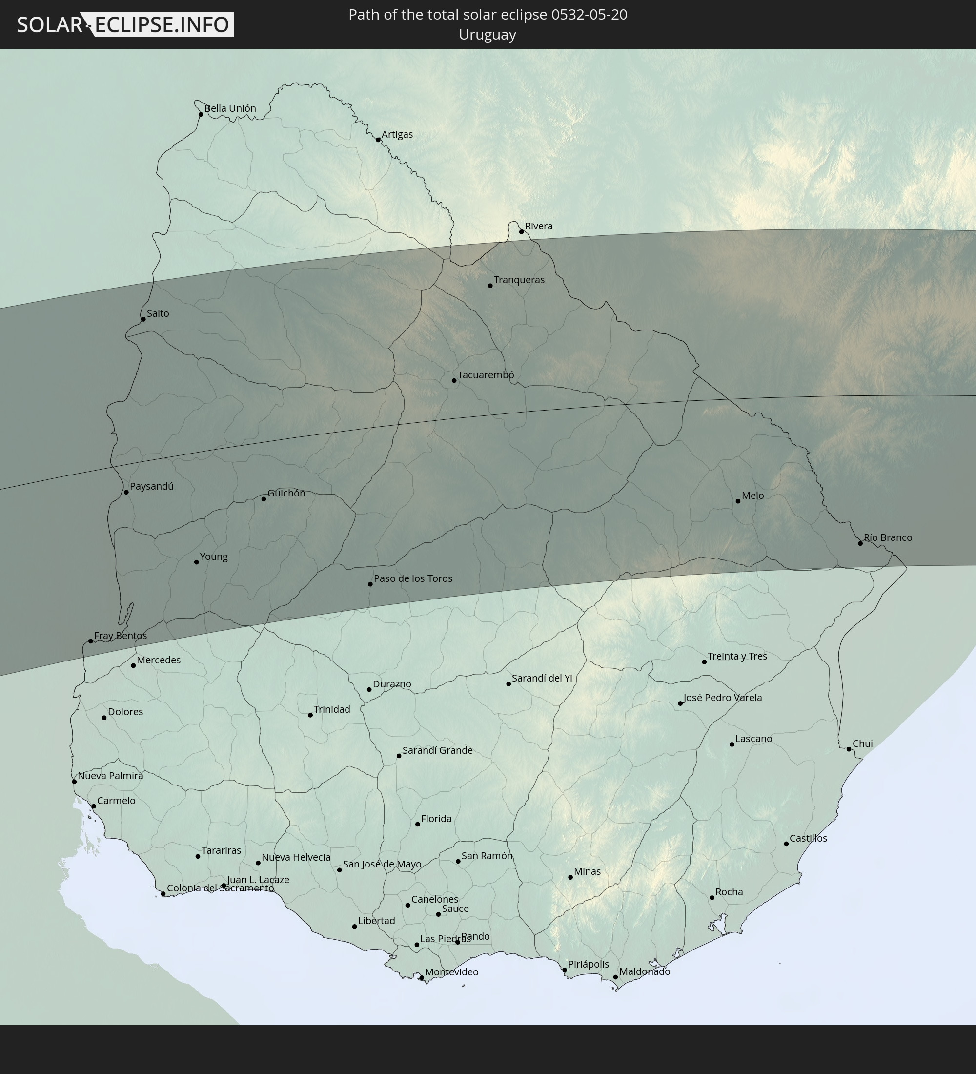 Uruguay
In den folgenden Ländern ist die Sonnenfinsternis partiell zu sehen


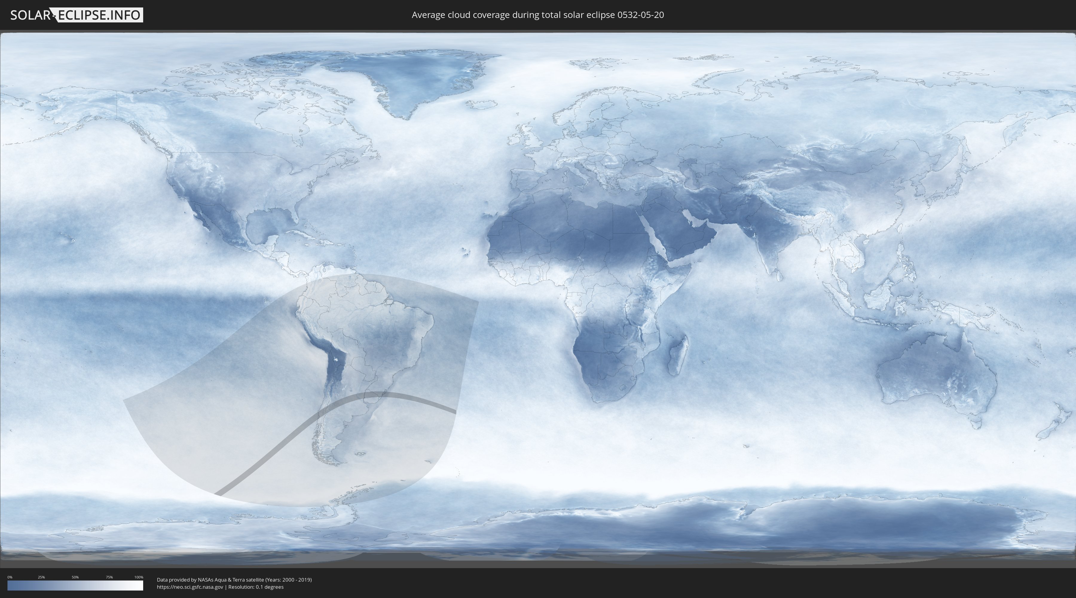
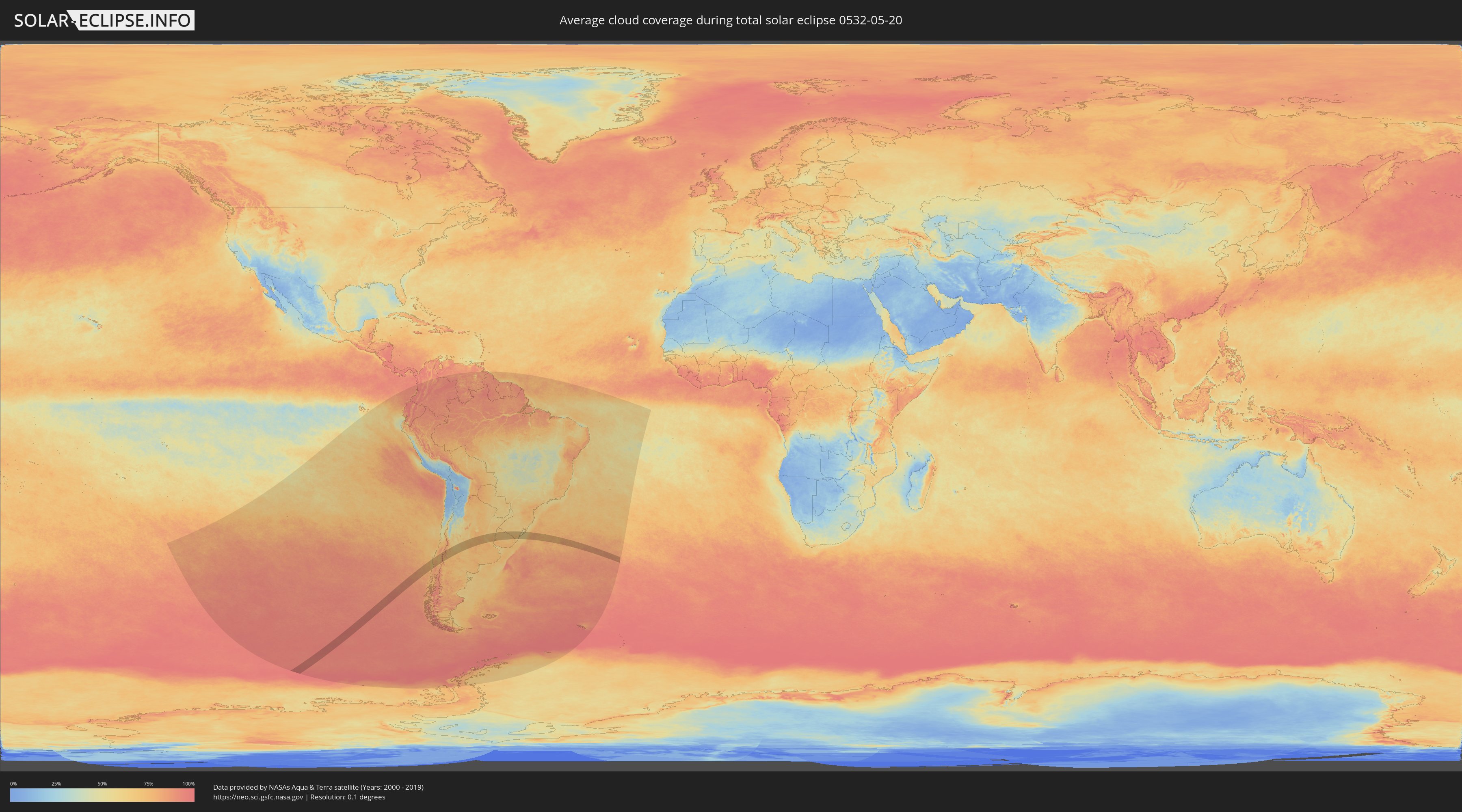
How will be the weather during the total solar eclipse on 05/20/0532?
Where is the best place to see the total solar eclipse of 05/20/0532?
The following maps show the average cloud coverage for the day of the total solar eclipse.
With the help of these maps, it is possible to find the place along the eclipse path, which has the best
chance of a cloudless sky.
Nevertheless, you should consider local circumstances and inform about the weather of your chosen
observation site.
The data is provided by NASAs satellites
AQUA and TERRA.
The cloud maps are averaged over a period of 19 years (2000 - 2019).
Detailed country maps
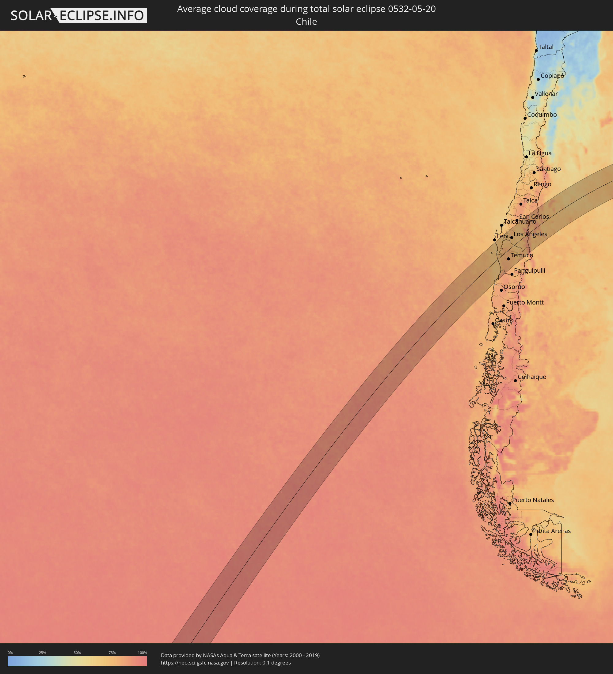 Chile
Chile
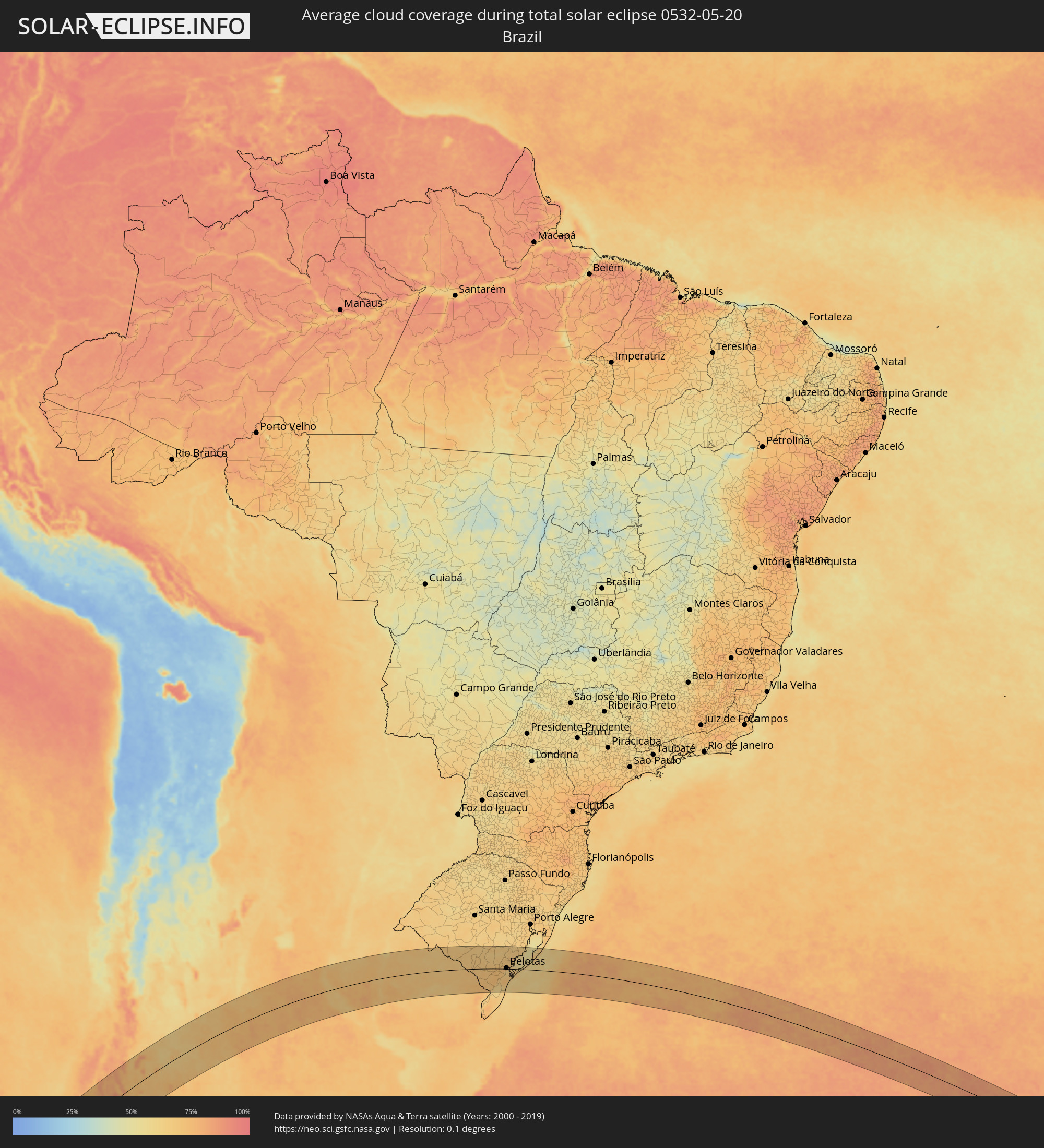 Brazil
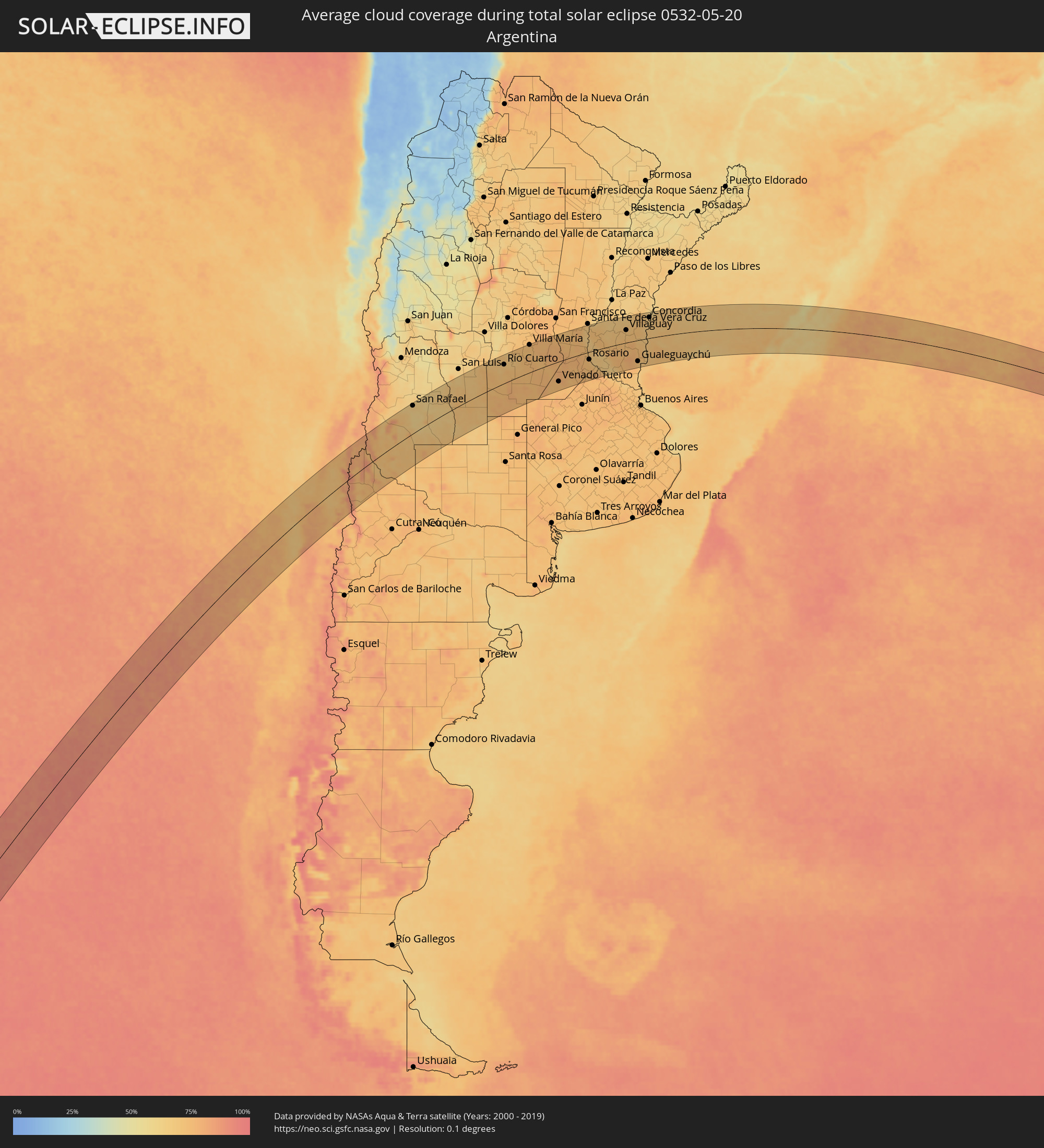 Argentina
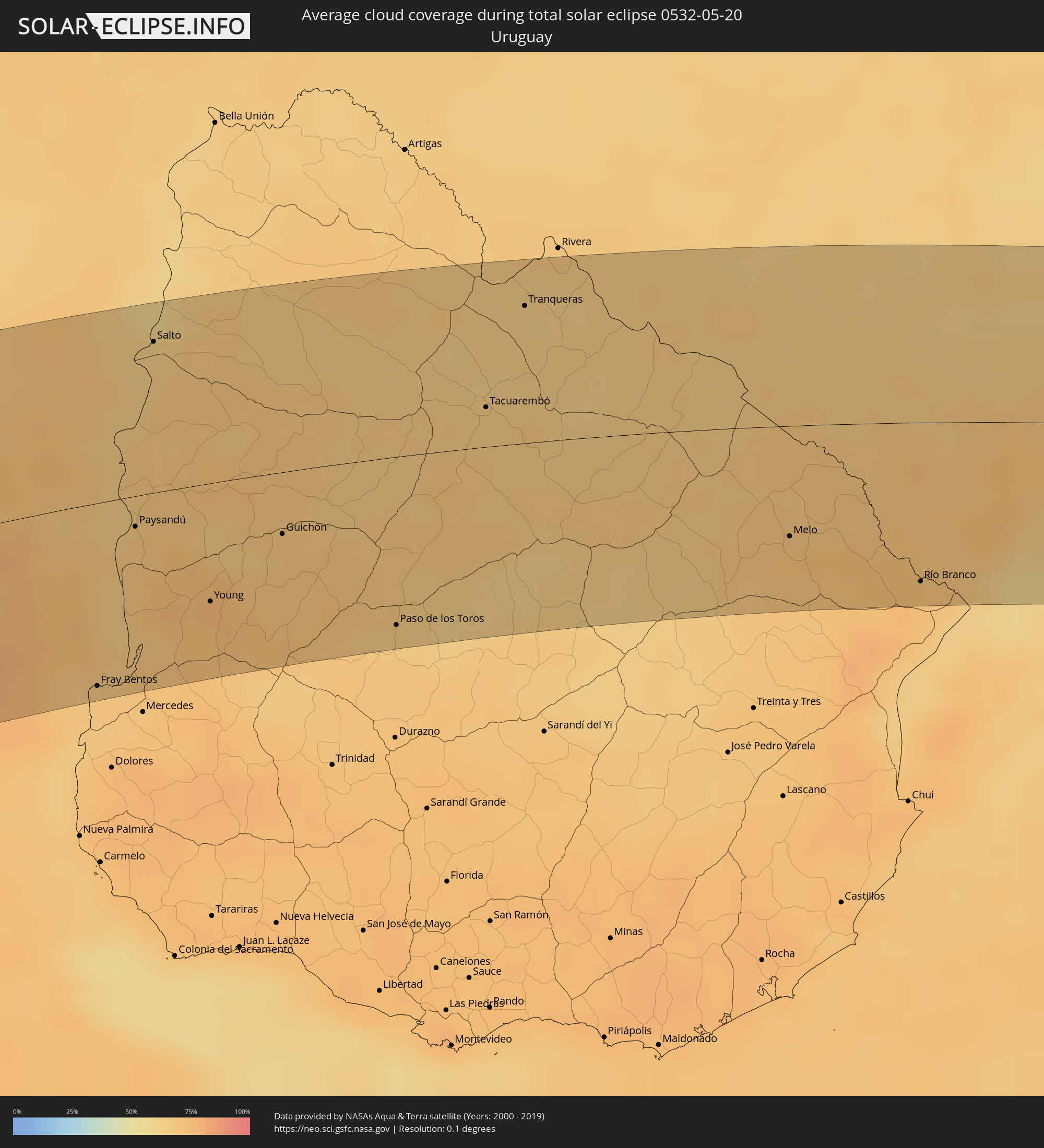 Uruguay
Cities inside the path of the eclipse
The following table shows all locations with a population of more than 5,000 inside the eclipse path. Cities which have more than 100,000 inhabitants are marked bold. A click at the locations opens a detailed map.
| City | Type | Eclipse duration | Local time of max. eclipse | Distance to central line | Ø Cloud coverage |
 Cañete, Biobío
|
total | - | 12:42:44 UTC-04:42 | 77 km | 69% |
|
Carahue, Araucanía
|
total | - | 12:42:24 UTC-04:42 | 13 km | 76% |
|
Nueva Imperial, Araucanía
|
total | - | 12:42:48 UTC-04:42 | 28 km | 77% |
|
Angol, Araucanía
|
total | - | 12:44:09 UTC-04:42 | 39 km | 74% |
|
La Laja, Biobío
|
total | - | 12:44:38 UTC-04:42 | 83 km | 71% |
|
Nacimiento, Biobío
|
total | - | 12:44:31 UTC-04:42 | 62 km | 70% |
|
Traiguén, Araucanía
|
total | - | 12:43:49 UTC-04:42 | 2 km | 78% |
|
Pitrufquén, Araucanía
|
total | - | 12:43:13 UTC-04:42 | 66 km | 80% |
|
Loncoche, Araucanía
|
total | - | 12:42:53 UTC-04:42 | 98 km | 80% |
|
Freire, Araucanía
|
total | - | 12:43:16 UTC-04:42 | 63 km | 80% |
|
Temuco, Araucanía
|
total | - | 12:43:31 UTC-04:42 | 47 km | 79% |
|
Yumbel, Biobío
|
total | - | 12:45:08 UTC-04:42 | 90 km | 72% |
|
Lautaro, Araucanía
|
total | - | 12:44:02 UTC-04:42 | 39 km | 76% |
|
Collipulli, Araucanía
|
total | - | 12:44:35 UTC-04:42 | 10 km | 74% |
|
Cabrero, Biobío
|
total | - | 12:45:31 UTC-04:42 | 87 km | 76% |
|
Los Ángeles, Biobío
|
total | - | 12:45:12 UTC-04:42 | 47 km | 73% |
|
Victoria, Araucanía
|
total | - | 12:44:32 UTC-04:42 | 20 km | 75% |
|
Mulchén, Biobío
|
total | - | 12:45:12 UTC-04:42 | 19 km | 70% |
|
Vilcún, Araucanía
|
total | - | 12:44:20 UTC-04:42 | 63 km | 76% |
|
Coihueco, Biobío
|
total | - | 12:47:07 UTC-04:42 | 91 km | 73% |
 Chos Malal, Neuquén Province
|
total | - | 13:15:37 UTC-04:16 | 60 km | 75% |
|
San Rafael, Mendoza Province
|
total | - | 13:22:46 UTC-04:16 | 94 km | 67% |
|
Villa Mercedes, San Luis Province
|
total | - | 13:30:08 UTC-04:16 | 58 km | 72% |
|
Justo Daract, San Luis Province
|
total | - | 13:30:30 UTC-04:16 | 28 km | 74% |
|
Vicuña Mackenna, Cordoba Province
|
total | - | 13:32:07 UTC-04:16 | 9 km | 72% |
|
Huinca Renancó, Cordoba Province
|
total | - | 13:31:00 UTC-04:16 | 102 km | 77% |
|
Río Cuarto, Cordoba Province
|
total | - | 13:33:13 UTC-04:16 | 70 km | 69% |
|
General Cabrera, Cordoba Province
|
total | - | 13:34:39 UTC-04:16 | 85 km | 70% |
|
Laboulaye, Cordoba Province
|
total | - | 13:33:59 UTC-04:16 | 67 km | 76% |
|
La Carlota, Cordoba Province
|
total | - | 13:35:06 UTC-04:16 | 2 km | 75% |
|
Villa Nueva, Cordoba Province
|
total | - | 13:36:29 UTC-04:16 | 102 km | 75% |
|
Villa María, Cordoba Province
|
total | - | 13:36:32 UTC-04:16 | 105 km | 75% |
|
Rufino, Santa Fe Province
|
total | - | 13:35:14 UTC-04:16 | 106 km | 75% |
|
Bell Ville, Cordoba Province
|
total | - | 13:37:26 UTC-04:16 | 64 km | 76% |
|
Leones, Cordoba Province
|
total | - | 13:38:13 UTC-04:16 | 48 km | 78% |
|
Corral de Bustos, Cordoba Province
|
total | - | 13:37:39 UTC-04:16 | 21 km | 75% |
|
Marcos Juárez, Cordoba Province
|
total | - | 13:38:35 UTC-04:16 | 38 km | 76% |
|
Venado Tuerto, Santa Fe Province
|
total | - | 13:37:29 UTC-04:16 | 76 km | 75% |
|
El Trébol, Santa Fe Province
|
total | - | 13:40:06 UTC-04:16 | 79 km | 74% |
|
Armstrong, Santa Fe Province
|
total | - | 13:39:32 UTC-04:16 | 14 km | 76% |
|
Las Rosas, Santa Fe Province
|
total | - | 13:39:59 UTC-04:16 | 46 km | 74% |
|
Las Parejas, Santa Fe Province
|
total | - | 13:39:51 UTC-04:16 | 22 km | 75% |
|
Firmat, Santa Fe Province
|
total | - | 13:38:53 UTC-04:16 | 61 km | 75% |
|
Cañada de Gómez, Santa Fe Province
|
total | - | 13:39:55 UTC-04:16 | 5 km | 76% |
|
Gálvez, Santa Fe Province
|
total | - | 13:41:21 UTC-04:16 | 84 km | 74% |
|
Totoras, Santa Fe Province
|
total | - | 13:40:42 UTC-04:16 | 23 km | 74% |
|
Casilda, Santa Fe Province
|
total | - | 13:40:05 UTC-04:16 | 26 km | 77% |
|
Carcarañá, Santa Fe Province
|
total | - | 13:40:22 UTC-04:16 | 6 km | 77% |
|
Coronda, Santa Fe Province
|
total | - | 13:42:03 UTC-04:16 | 82 km | 67% |
|
Roldán, Santa Fe Province
|
total | - | 13:40:50 UTC-04:16 | 17 km | 75% |
|
Funes, Santa Fe Province
|
total | - | 13:41:01 UTC-04:16 | 22 km | 74% |
|
Fray Luis A. Beltrán, Santa Fe Province
|
total | - | 13:41:21 UTC-04:16 | 11 km | 72% |
|
Capitán Bermúdez, Santa Fe Province
|
total | - | 13:41:20 UTC-04:16 | 14 km | 72% |
|
Rosario, Santa Fe Province
|
total | - | 13:41:19 UTC-04:16 | 30 km | 68% |
|
Diamante, Entre Ríos Province
|
total | - | 13:42:31 UTC-04:16 | 65 km | 68% |
|
Paraná, Entre Ríos Province
|
total | - | 13:43:12 UTC-04:16 | 98 km | 70% |
|
Arroyo Seco, Santa Fe Province
|
total | - | 13:41:19 UTC-04:16 | 55 km | 74% |
|
Villa Constitución, Santa Fe Province
|
total | - | 13:41:35 UTC-04:16 | 68 km | 70% |
|
Crespo, Entre Ríos Province
|
total | - | 13:43:15 UTC-04:16 | 61 km | 73% |
|
San Nicolás de los Arroyos, Buenos Aires
|
total | - | 13:41:39 UTC-04:16 | 82 km | 73% |
|
Victoria, Entre Ríos Province
|
total | - | 13:42:46 UTC-04:16 | 7 km | 65% |
|
Viale, Entre Ríos Province
|
total | - | 13:44:06 UTC-04:16 | 71 km | 69% |
|
Gualeguay, Entre Ríos Province
|
total | - | 13:43:47 UTC-04:16 | 82 km | 74% |
|
Rosario del Tala, Entre Ríos Province
|
total | - | 13:45:16 UTC-04:16 | 5 km | 73% |
|
Villaguay, Entre Ríos Province
|
total | - | 13:46:07 UTC-04:16 | 50 km | 70% |
|
Gualeguaychú, Entre Ríos Province
|
total | - | 13:45:34 UTC-04:16 | 84 km | 71% |
|
San Salvador, Entre Ríos Province
|
total | - | 13:47:30 UTC-04:16 | 67 km | 71% |
|
Villa Elisa, Entre Ríos Province
|
total | - | 13:46:58 UTC-04:16 | 6 km | 69% |
 Fray Bentos, Río Negro
|
total | - | 14:17:47 UTC-03:44 | 100 km | 70% |
|
Concepción del Uruguay, Entre Ríos Province
|
total | - | 13:46:51 UTC-04:16 | 32 km | 66% |
|
Paysandú, Paysandú
|
total | - | 14:19:21 UTC-03:44 | 17 km | 69% |
|
Concordia, Entre Ríos Province
|
total | - | 13:48:48 UTC-04:16 | 84 km | 64% |
|
Salto, Salto
|
total | - | 14:20:52 UTC-03:44 | 84 km | 64% |
|
Young, Río Negro
|
total | - | 14:19:43 UTC-03:44 | 65 km | 73% |
|
Guichón, Paysandú
|
total | - | 14:21:02 UTC-03:44 | 34 km | 69% |
|
Paso de los Toros, Tacuarembó
|
total | - | 14:21:43 UTC-03:44 | 94 km | 67% |
|
Tacuarembó, Tacuarembó
|
total | - | 14:24:18 UTC-03:44 | 22 km | 68% |
|
Tranqueras, Rivera
|
total | - | 14:25:28 UTC-03:44 | 78 km | 65% |
 Dom Pedrito, Rio Grande do Sul
|
total | - | 15:06:12 UTC-03:06 | 94 km | 67% |
|
Melo, Cerro Largo
|
total | - | 14:26:46 UTC-03:44 | 62 km | 72% |
|
Bagé, Rio Grande do Sul
|
total | - | 15:06:45 UTC-03:06 | 53 km | 66% |
|
Herval, Rio Grande do Sul
|
total | - | 15:07:03 UTC-03:06 | 25 km | 71% |
|
Río Branco, Cerro Largo
|
total | - | 14:27:51 UTC-03:44 | 89 km | 74% |
|
Pinheiro Machado, Rio Grande do Sul
|
total | - | 15:07:43 UTC-03:06 | 24 km | 67% |
|
Jaguarão, Rio Grande do Sul
|
total | - | 15:06:18 UTC-03:06 | 86 km | 74% |
|
Arroio Grande, Rio Grande do Sul
|
total | - | 15:07:18 UTC-03:06 | 50 km | 73% |
|
Canguçu, Rio Grande do Sul
|
total | - | 15:09:15 UTC-03:06 | 44 km | 67% |
|
Pelotas, Rio Grande do Sul
|
total | - | 15:09:17 UTC-03:06 | 3 km | 64% |
|
Rio Grande, Rio Grande do Sul
|
total | - | 15:09:20 UTC-03:06 | 26 km | 66% |
|
São Lourenço do Sul, Rio Grande do Sul
|
total | - | 15:10:31 UTC-03:06 | 49 km | 61% |