Total solar eclipse of 02/26/0556
| Day of week: | Thursday |
| Maximum duration of eclipse: | 03m19s |
| Maximum width of eclipse path: | 222 km |
| Saros cycle: | 97 |
| Coverage: | 100% |
| Magnitude: | 1.0433 |
| Gamma: | 0.7721 |
Wo kann man die Sonnenfinsternis vom 02/26/0556 sehen?

Die Sonnenfinsternis am 02/26/0556 kann man in 38 Ländern als partielle Sonnenfinsternis beobachten.
Der Finsternispfad verläuft durch 4 Länder. Nur in diesen Ländern ist sie als total Sonnenfinsternis zu sehen.
In den folgenden Ländern ist die Sonnenfinsternis total zu sehen
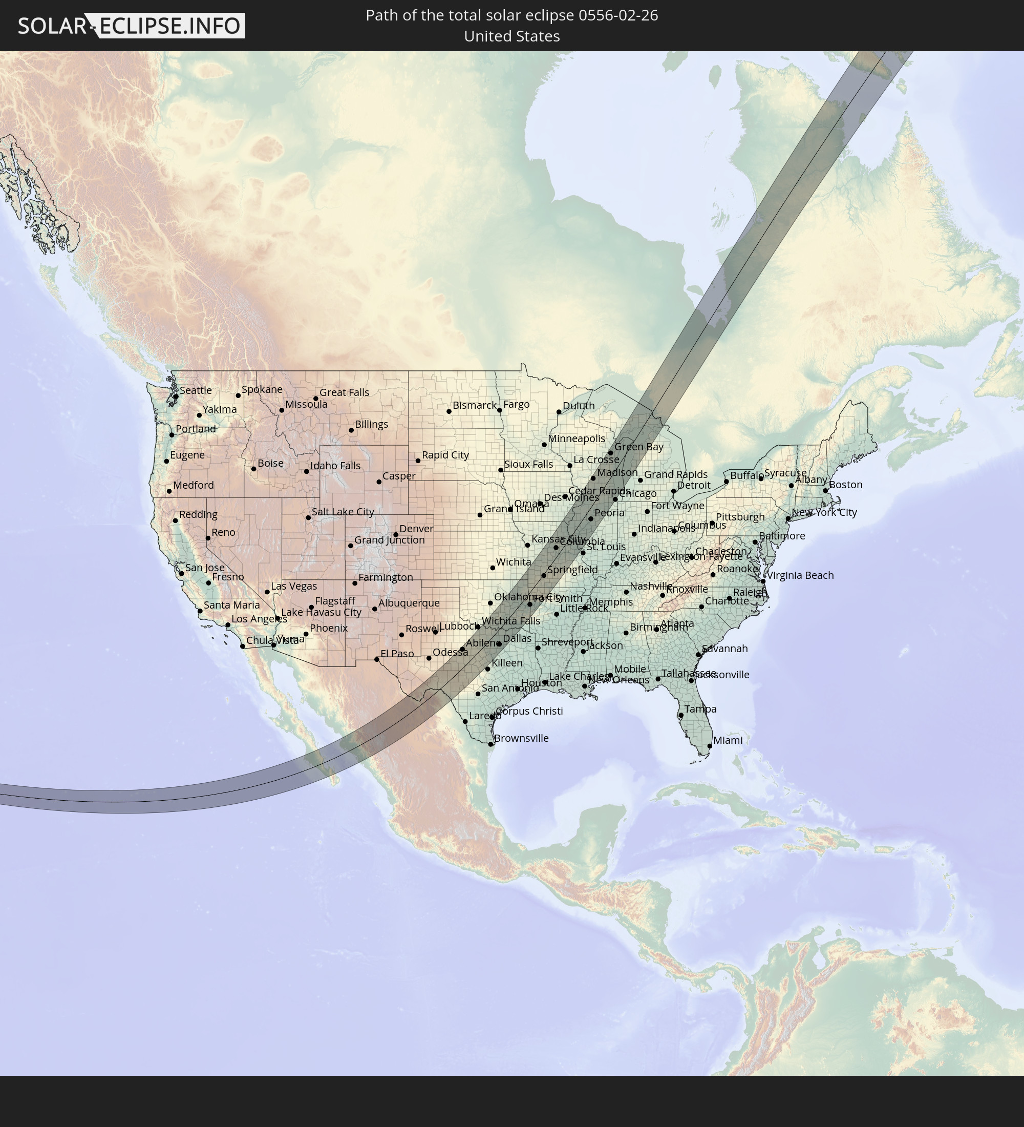 United States
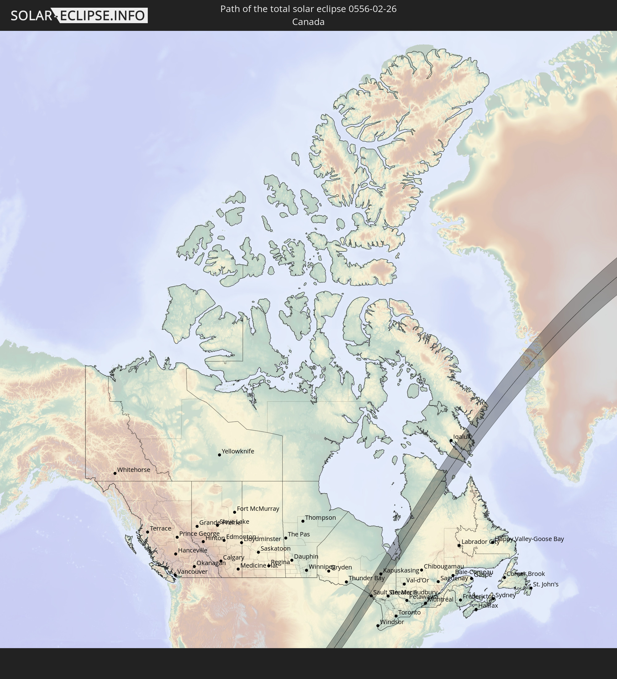 Canada
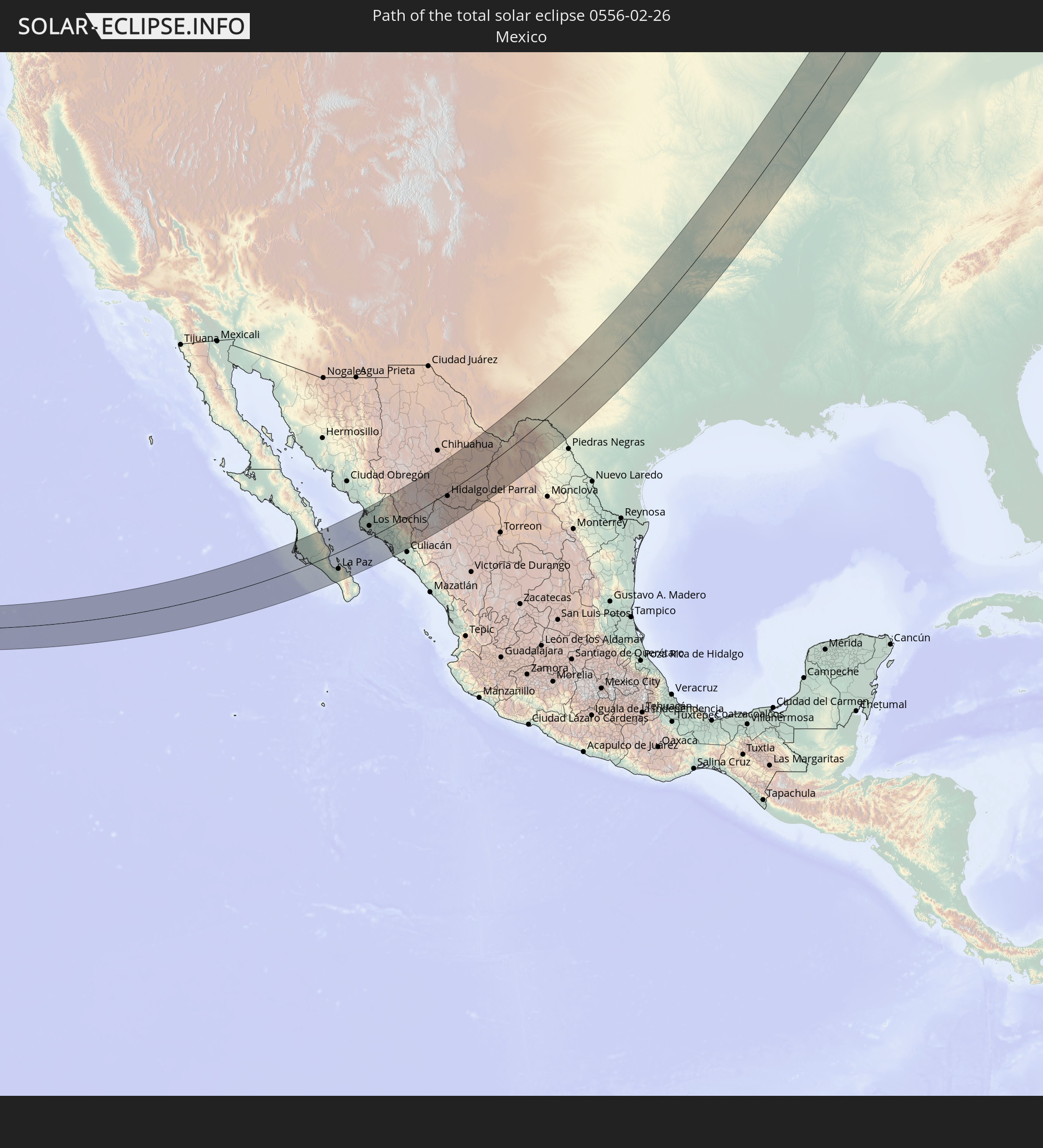 Mexico
 Greenland
In den folgenden Ländern ist die Sonnenfinsternis partiell zu sehen
 United States
 United States Minor Outlying Islands
 Canada
 Mexico
 Greenland
 Guatemala
 Ecuador
 El Salvador
 Honduras
 Belize
 Nicaragua
 Costa Rica
 Cuba
Cuba
 Panama
 Colombia
 Cayman Islands
 Peru
Peru
 The Bahamas
 Jamaica
 Haiti
Haiti
 Venezuela
 Turks and Caicos Islands
 Dominican Republic
 Aruba
Aruba
 Puerto Rico
 United States Virgin Islands
 Bermuda
 British Virgin Islands
 Anguilla
 Collectivity of Saint Martin
 Saint Barthélemy
 Saint Kitts and Nevis
 Antigua and Barbuda
 Montserrat
 Guadeloupe
 Saint Pierre and Miquelon
 Portugal
 Iceland
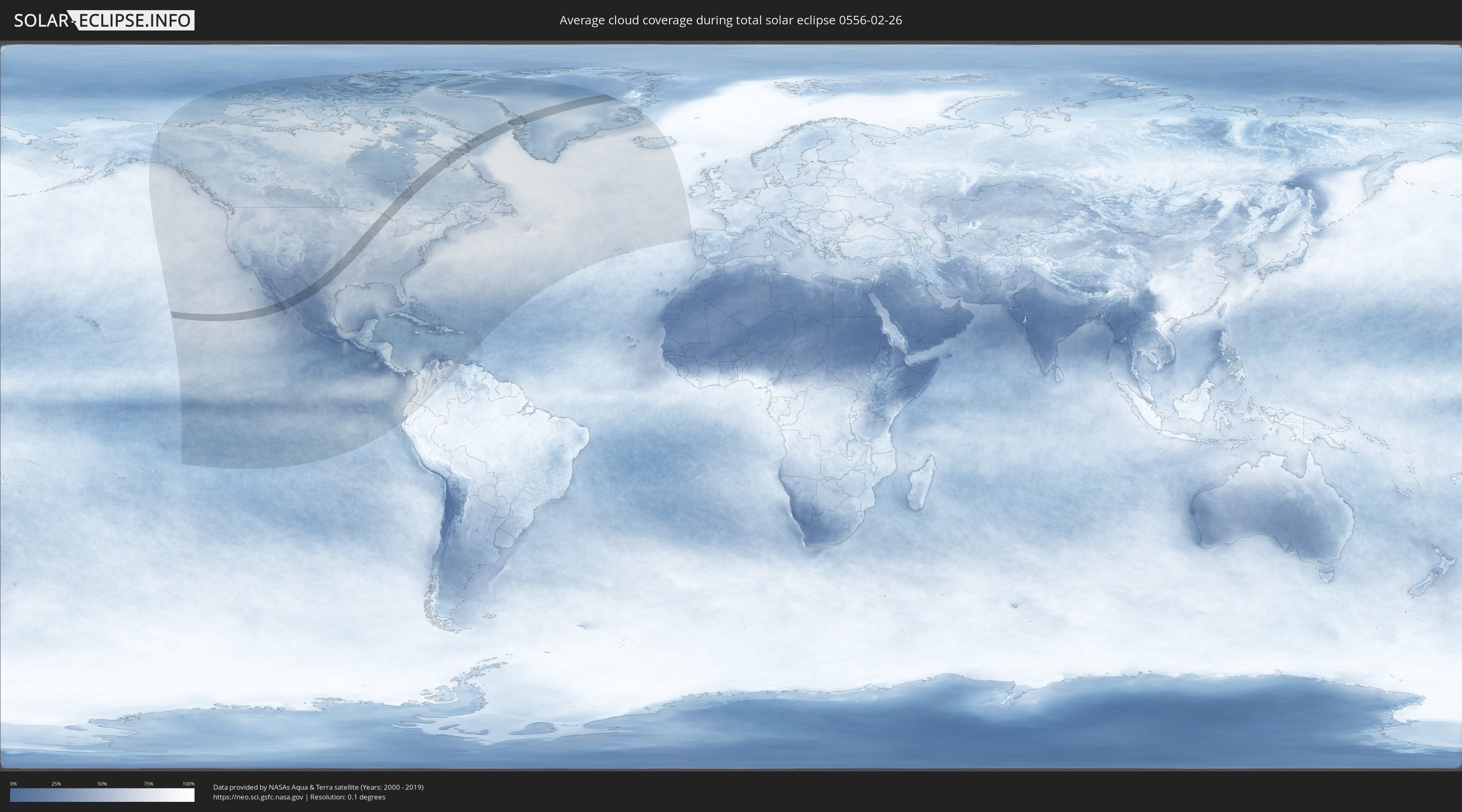
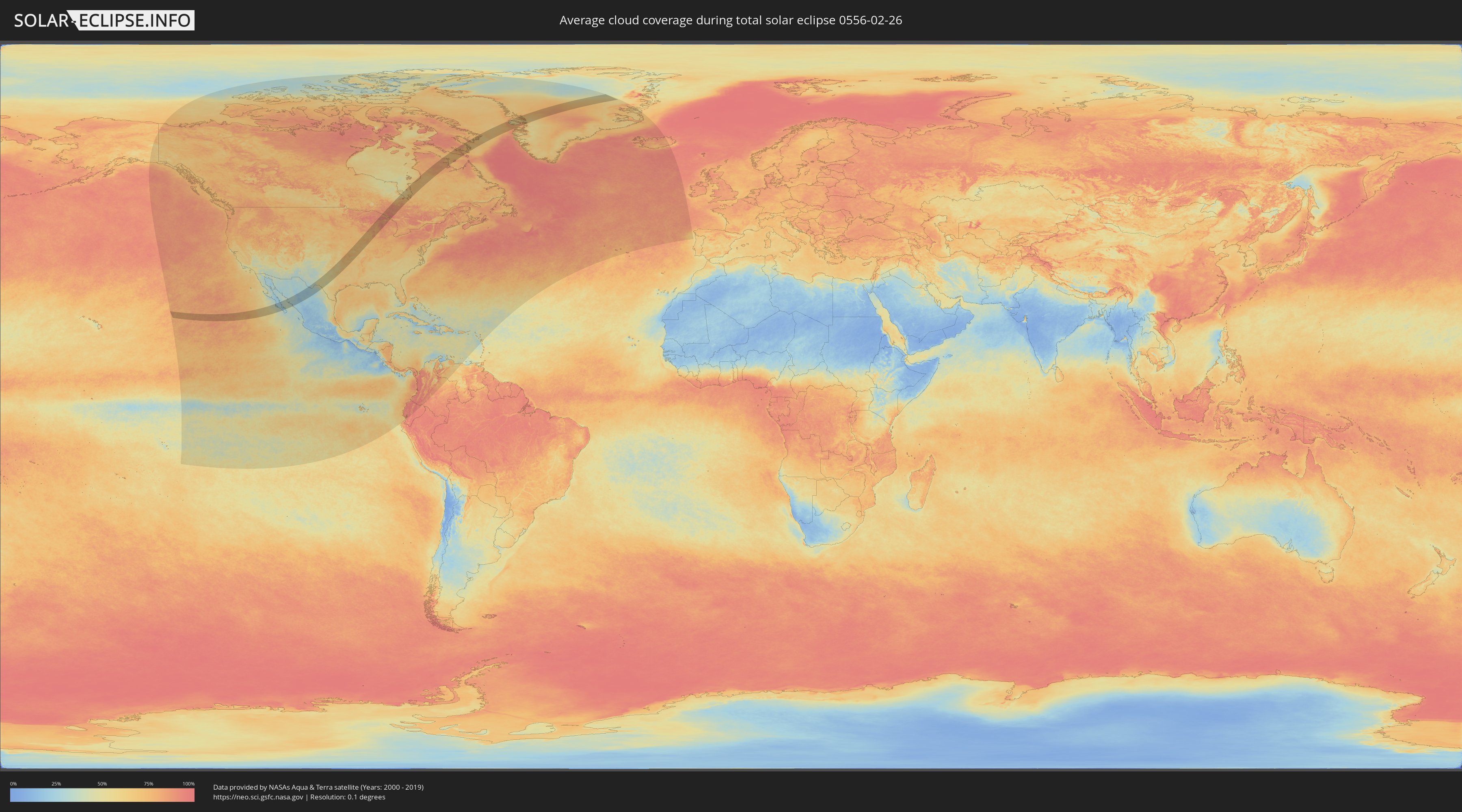
How will be the weather during the total solar eclipse on 02/26/0556?
Where is the best place to see the total solar eclipse of 02/26/0556?
The following maps show the average cloud coverage for the day of the total solar eclipse.
With the help of these maps, it is possible to find the place along the eclipse path, which has the best
chance of a cloudless sky.
Nevertheless, you should consider local circumstances and inform about the weather of your chosen
observation site.
The data is provided by NASAs satellites
AQUA and TERRA.
The cloud maps are averaged over a period of 19 years (2000 - 2019).
Detailed country maps
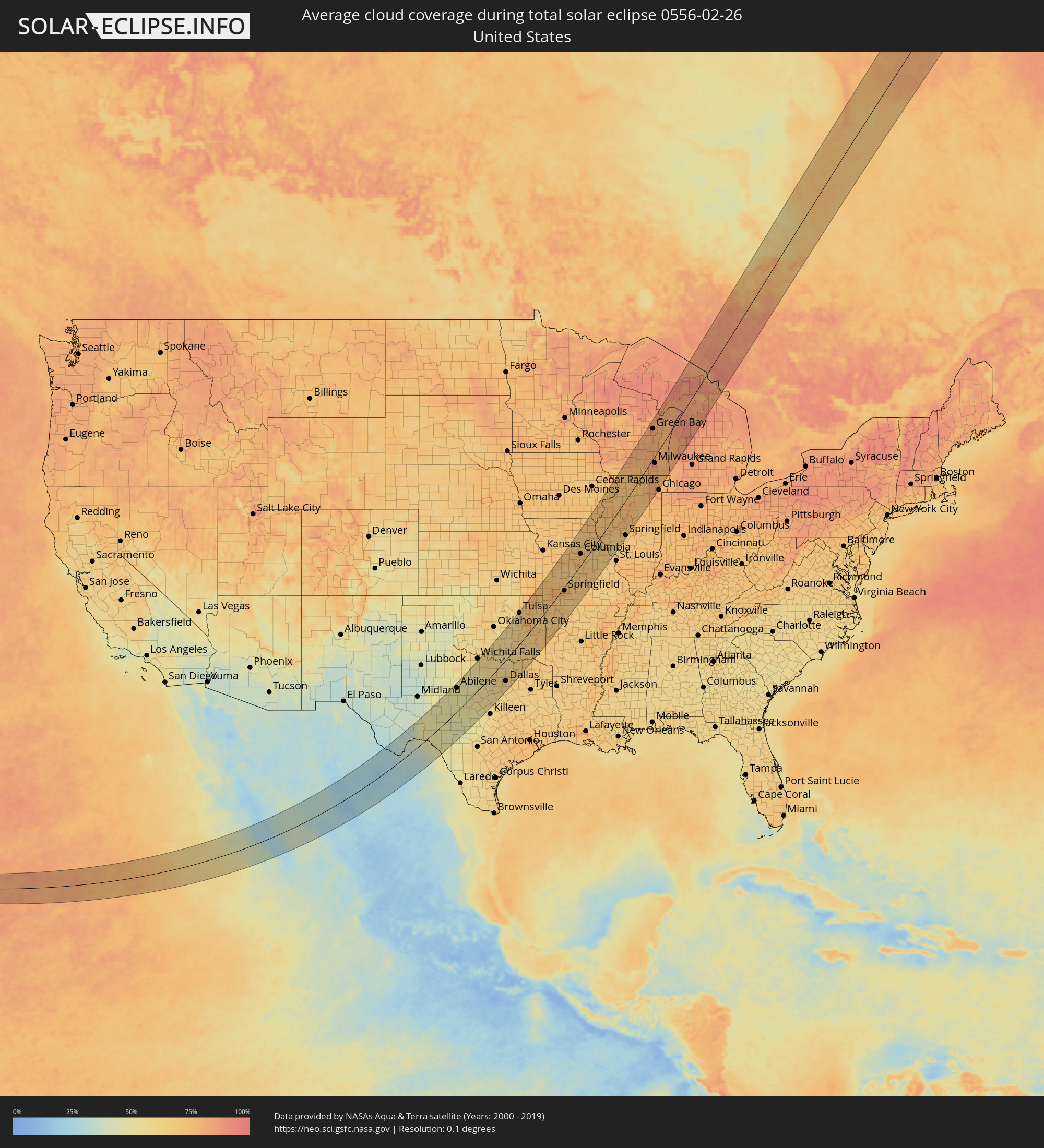 United States
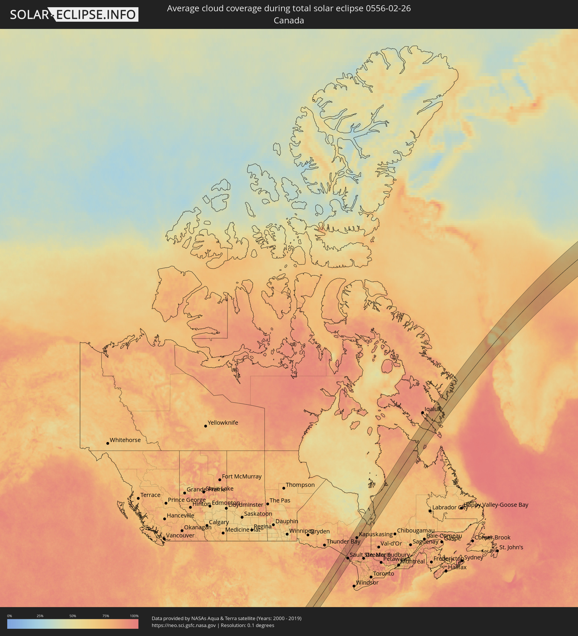 Canada
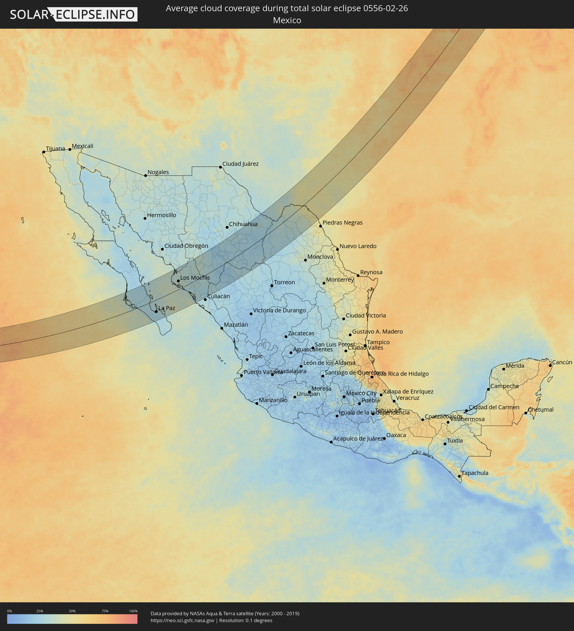 Mexico
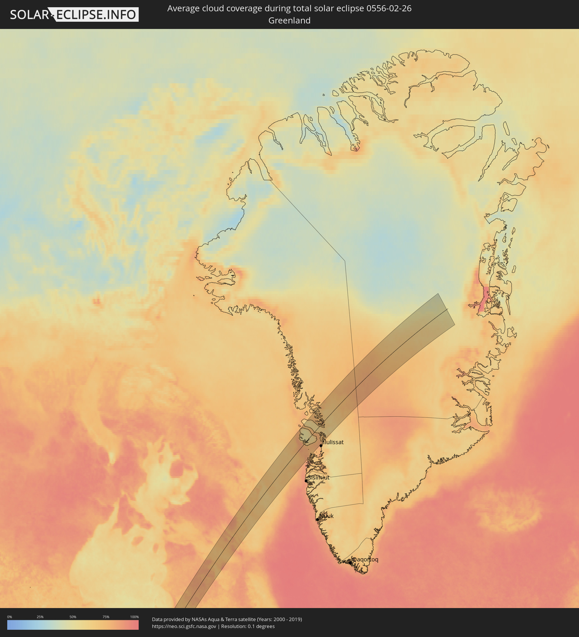 Greenland
Cities inside the path of the eclipse
The following table shows all locations with a population of more than 5,000 inside the eclipse path. Cities which have more than 100,000 inhabitants are marked bold. A click at the locations opens a detailed map.
| City | Type | Eclipse duration | Local time of max. eclipse | Distance to central line | Ø Cloud coverage |
|
Ciudad Insurgentes, Baja California Sur
|
total | - | 08:56:10 UTC-07:05 | 106 km | 28% |
|
Ciudad Constitución, Baja California Sur
|
total | - | 08:55:53 UTC-07:05 | 78 km | 26% |
|
La Paz, Baja California Sur
|
total | - | 08:55:55 UTC-07:05 | 66 km | 26% |
|
Higuera de Zaragoza, Sinaloa
|
total | - | 09:00:26 UTC-07:05 | 75 km | 34% |
|
Ahome, Sinaloa
|
total | - | 09:00:30 UTC-07:05 | 64 km | 36% |
|
Topolobampo, Sinaloa
|
total | - | 09:00:05 UTC-07:05 | 27 km | 36% |
|
San Miguel Zapotitlan, Sinaloa
|
total | - | 09:00:43 UTC-07:05 | 61 km | 34% |
|
Los Mochis, Sinaloa
|
total | - | 09:00:30 UTC-07:05 | 44 km | 38% |
|
Juan Jose Rios, Sinaloa
|
total | - | 09:00:39 UTC-07:05 | 32 km | 36% |
|
San Blas, Sinaloa
|
total | - | 09:01:19 UTC-07:05 | 61 km | 31% |
|
Adolfo Ruíz Cortínes, Sinaloa
|
total | - | 09:00:44 UTC-07:05 | 28 km | 36% |
|
Leyva Solano, Sinaloa
|
total | - | 09:00:43 UTC-07:05 | 14 km | 33% |
|
El Fuerte de Montes Claros, Sinaloa
|
total | - | 09:02:07 UTC-07:05 | 88 km | 33% |
|
Guasave, Sinaloa
|
total | - | 09:00:46 UTC-07:05 | 3 km | 30% |
|
Choix, Sinaloa
|
total | - | 09:03:01 UTC-07:05 | 102 km | 30% |
|
Guamúchil, Sinaloa
|
total | - | 09:01:04 UTC-07:05 | 32 km | 28% |
|
La Reforma, Sinaloa
|
total | - | 09:00:24 UTC-07:05 | 70 km | 31% |
|
Mocorito, Sinaloa
|
total | - | 09:01:18 UTC-07:05 | 37 km | 27% |
|
General Ángel Flores (La Palma), Sinaloa
|
total | - | 09:00:27 UTC-07:05 | 115 km | 27% |
|
Adolfo López Mateos (El Tamarindo), Sinaloa
|
total | - | 09:00:37 UTC-07:05 | 108 km | 27% |
|
Santa Bárbara, Chihuahua
|
total | - | 09:06:31 UTC-07:05 | 16 km | 25% |
|
Hidalgo del Parral, Chihuahua
|
total | - | 09:06:57 UTC-07:05 | 13 km | 26% |
|
Ampliación Colonia Lázaro Cárdenas, Chihuahua
|
partial | - | 09:09:42 UTC-07:05 | 119 km | 26% |
|
Rosales, Chihuahua
|
total | - | 09:09:25 UTC-07:05 | 98 km | 27% |
|
Naica, Chihuahua
|
total | - | 09:08:54 UTC-07:05 | 64 km | 24% |
|
Pedro Meoqui, Chihuahua
|
total | - | 09:09:42 UTC-07:05 | 103 km | 27% |
|
Ciudad Delicias, Chihuahua
|
total | - | 09:09:33 UTC-07:05 | 93 km | 28% |
|
Jiménez, Chihuahua
|
total | - | 09:09:54 UTC-07:05 | 103 km | 28% |
|
Saucillo, Chihuahua
|
total | - | 09:09:29 UTC-07:05 | 69 km | 25% |
|
Ciudad Camargo, Chihuahua
|
total | - | 09:09:01 UTC-07:05 | 30 km | 26% |
|
Ciudad Acuña, Coahuila
|
total | - | 09:47:10 UTC-06:36 | 78 km | 49% |
|
Del Rio, Texas
|
total | - | 10:23:55 UTC-06:00 | 78 km | 51% |
|
San Angelo, Texas
|
total | - | 10:28:27 UTC-06:00 | 65 km | 50% |
|
Abilene, Texas
|
total | - | 10:31:17 UTC-06:00 | 96 km | 55% |
|
Burleson, Texas
|
total | - | 10:35:06 UTC-06:00 | 62 km | 62% |
|
Fort Worth, Texas
|
total | - | 10:35:25 UTC-06:00 | 48 km | 63% |
|
Keller, Texas
|
total | - | 10:35:54 UTC-06:00 | 37 km | 66% |
|
Mansfield, Texas
|
total | - | 10:35:24 UTC-06:00 | 72 km | 64% |
|
Denton, Texas
|
total | - | 10:36:34 UTC-06:00 | 24 km | 60% |
|
Arlington, Texas
|
total | - | 10:35:46 UTC-06:00 | 62 km | 64% |
|
Flower Mound, Texas
|
total | - | 10:36:16 UTC-06:00 | 41 km | 64% |
|
Carrollton, Texas
|
total | - | 10:36:29 UTC-06:00 | 60 km | 68% |
|
DeSoto, Texas
|
total | - | 10:35:53 UTC-06:00 | 90 km | 63% |
|
Waxahachie, Texas
|
total | - | 10:35:32 UTC-06:00 | 106 km | 61% |
|
Frisco, Texas
|
total | - | 10:36:56 UTC-06:00 | 50 km | 70% |
|
Dallas, Texas
|
total | - | 10:36:18 UTC-06:00 | 79 km | 62% |
|
Plano, Texas
|
total | - | 10:36:54 UTC-06:00 | 69 km | 66% |
|
McKinney, Texas
|
total | - | 10:37:20 UTC-06:00 | 61 km | 64% |
|
Sherman, Texas
|
total | - | 10:38:07 UTC-06:00 | 29 km | 57% |
|
Mesquite, Texas
|
total | - | 10:36:36 UTC-06:00 | 94 km | 63% |
|
Rowlett, Texas
|
total | - | 10:36:54 UTC-06:00 | 87 km | 63% |
|
Tulsa, Oklahoma
|
total | - | 10:43:24 UTC-06:00 | 107 km | 66% |
|
Broken Arrow, Oklahoma
|
total | - | 10:43:32 UTC-06:00 | 86 km | 70% |
|
Muskogee, Oklahoma
|
total | - | 10:43:39 UTC-06:00 | 35 km | 74% |
|
Joplin, Missouri
|
total | - | 10:47:12 UTC-06:00 | 66 km | 68% |
|
Fort Smith, Arkansas
|
total | - | 10:44:31 UTC-06:00 | 59 km | 69% |
|
Fayetteville, Arkansas
|
total | - | 10:46:02 UTC-06:00 | 29 km | 71% |
|
Rogers, Arkansas
|
total | - | 10:46:32 UTC-06:00 | 13 km | 72% |
|
Springfield, Missouri
|
total | - | 10:49:15 UTC-06:00 | 12 km | 73% |
|
Columbia, Missouri
|
total | - | 10:53:28 UTC-06:00 | 34 km | 72% |
|
Jefferson City, Missouri
|
total | - | 10:53:07 UTC-06:00 | 1 km | 70% |
|
Quincy, Illinois
|
total | - | 10:56:21 UTC-06:00 | 32 km | 70% |
|
O'Fallon, Missouri
|
total | - | 10:55:42 UTC-06:00 | 90 km | 71% |
|
Davenport, Iowa
|
total | - | 10:59:56 UTC-06:00 | 73 km | 77% |
|
Galesburg, Illinois
|
total | - | 10:59:24 UTC-06:00 | 23 km | 74% |
|
Springfield, Illinois
|
total | - | 10:58:46 UTC-06:00 | 100 km | 69% |
|
Peoria, Illinois
|
total | - | 11:00:10 UTC-06:00 | 47 km | 80% |
|
Madison, Wisconsin
|
total | - | 11:03:48 UTC-06:00 | 86 km | 85% |
|
Rockford, Illinois
|
total | - | 11:03:08 UTC-06:00 | 16 km | 77% |
|
Beloit, Wisconsin
|
total | - | 11:03:33 UTC-06:00 | 26 km | 75% |
|
Janesville, Wisconsin
|
total | - | 11:03:49 UTC-06:00 | 36 km | 77% |
|
Bloomington, Illinois
|
total | - | 11:00:44 UTC-06:00 | 102 km | 75% |
|
DeKalb, Illinois
|
total | - | 11:03:09 UTC-06:00 | 28 km | 71% |
|
Oshkosh, Wisconsin
|
total | - | 11:06:17 UTC-06:00 | 84 km | 82% |
|
Fond du Lac, Wisconsin
|
total | - | 11:06:06 UTC-06:00 | 62 km | 83% |
|
Appleton, Wisconsin
|
total | - | 11:06:47 UTC-06:00 | 90 km | 85% |
|
Aurora, Illinois
|
total | - | 11:03:32 UTC-06:00 | 69 km | 82% |
|
Crystal Lake, Illinois
|
total | - | 11:04:12 UTC-06:00 | 39 km | 80% |
|
Elgin, Illinois
|
total | - | 11:03:59 UTC-06:00 | 54 km | 81% |
|
Waukesha, Wisconsin
|
total | - | 11:05:23 UTC-06:00 | 2 km | 83% |
|
West Bend, Wisconsin
|
total | - | 11:06:00 UTC-06:00 | 24 km | 80% |
|
Menomonee Falls, Wisconsin
|
total | - | 11:05:46 UTC-06:00 | 5 km | 85% |
|
Wheaton, Illinois
|
total | - | 11:03:59 UTC-06:00 | 77 km | 82% |
|
Joliet, Illinois
|
total | - | 11:03:33 UTC-06:00 | 100 km | 77% |
|
Bolingbrook, Illinois
|
total | - | 11:03:49 UTC-06:00 | 90 km | 81% |
|
Franklin, Wisconsin
|
total | - | 11:05:29 UTC-06:00 | 18 km | 82% |
|
Green Bay, Wisconsin
|
total | - | 11:07:40 UTC-06:00 | 78 km | 84% |
|
Mundelein, Illinois
|
total | - | 11:04:41 UTC-06:00 | 59 km | 82% |
|
Arlington Heights, Illinois
|
total | - | 11:04:29 UTC-06:00 | 72 km | 85% |
|
Milwaukee, Wisconsin
|
total | - | 11:05:53 UTC-06:00 | 18 km | 87% |
|
Waukegan, Illinois
|
total | - | 11:05:03 UTC-06:00 | 64 km | 80% |
|
Kenosha, Wisconsin
|
total | - | 11:05:23 UTC-06:00 | 52 km | 80% |
|
Highland Park, Illinois
|
total | - | 11:04:52 UTC-06:00 | 78 km | 81% |
|
Racine, Wisconsin
|
total | - | 11:05:38 UTC-06:00 | 46 km | 79% |
|
Cicero, Illinois
|
total | - | 11:04:28 UTC-06:00 | 102 km | 82% |
|
Sheboygan, Wisconsin
|
total | - | 11:07:05 UTC-06:00 | 12 km | 80% |
|
Evanston, Illinois
|
total | - | 11:04:50 UTC-06:00 | 94 km | 84% |
|
Manitowoc, Wisconsin
|
total | - | 11:07:37 UTC-06:00 | 28 km | 79% |
|
Sault Ste. Marie, Ontario
|
total | - | 12:15:04 UTC-05:00 | 46 km | 79% |
|
Kapuskasing, Ontario
|
total | - | 12:20:32 UTC-05:00 | 6 km | 82% |