Total solar eclipse of 05/01/0645
| Day of week: | Thursday |
| Maximum duration of eclipse: | 06m38s |
| Maximum width of eclipse path: | 257 km |
| Saros cycle: | 87 |
| Coverage: | 100% |
| Magnitude: | 1.0779 |
| Gamma: | -0.2115 |
Wo kann man die Sonnenfinsternis vom 05/01/0645 sehen?

Die Sonnenfinsternis am 05/01/0645 kann man in 80 Ländern als partielle Sonnenfinsternis beobachten.
Der Finsternispfad verläuft durch 14 Länder. Nur in diesen Ländern ist sie als total Sonnenfinsternis zu sehen.
In den folgenden Ländern ist die Sonnenfinsternis total zu sehen
 Peru
Peru
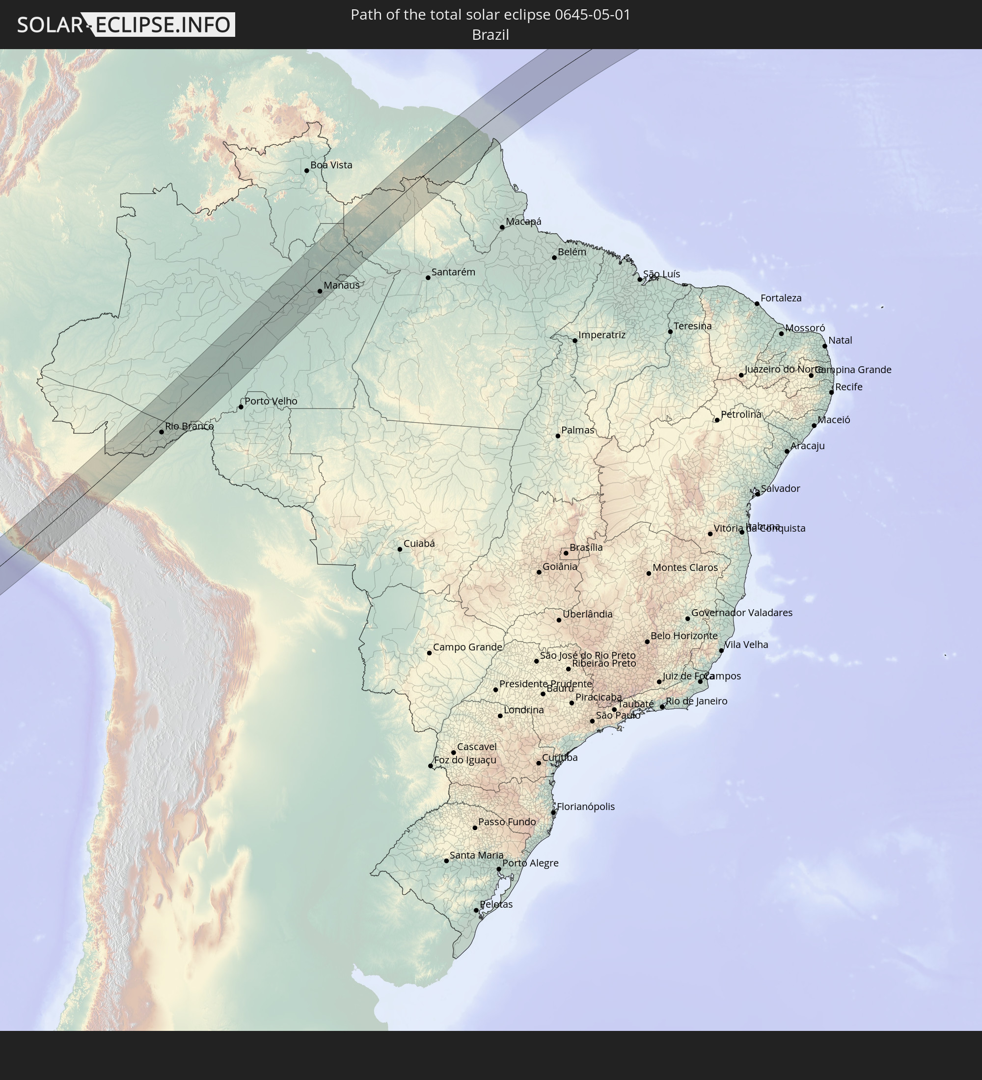 Brazil
 Bolivia
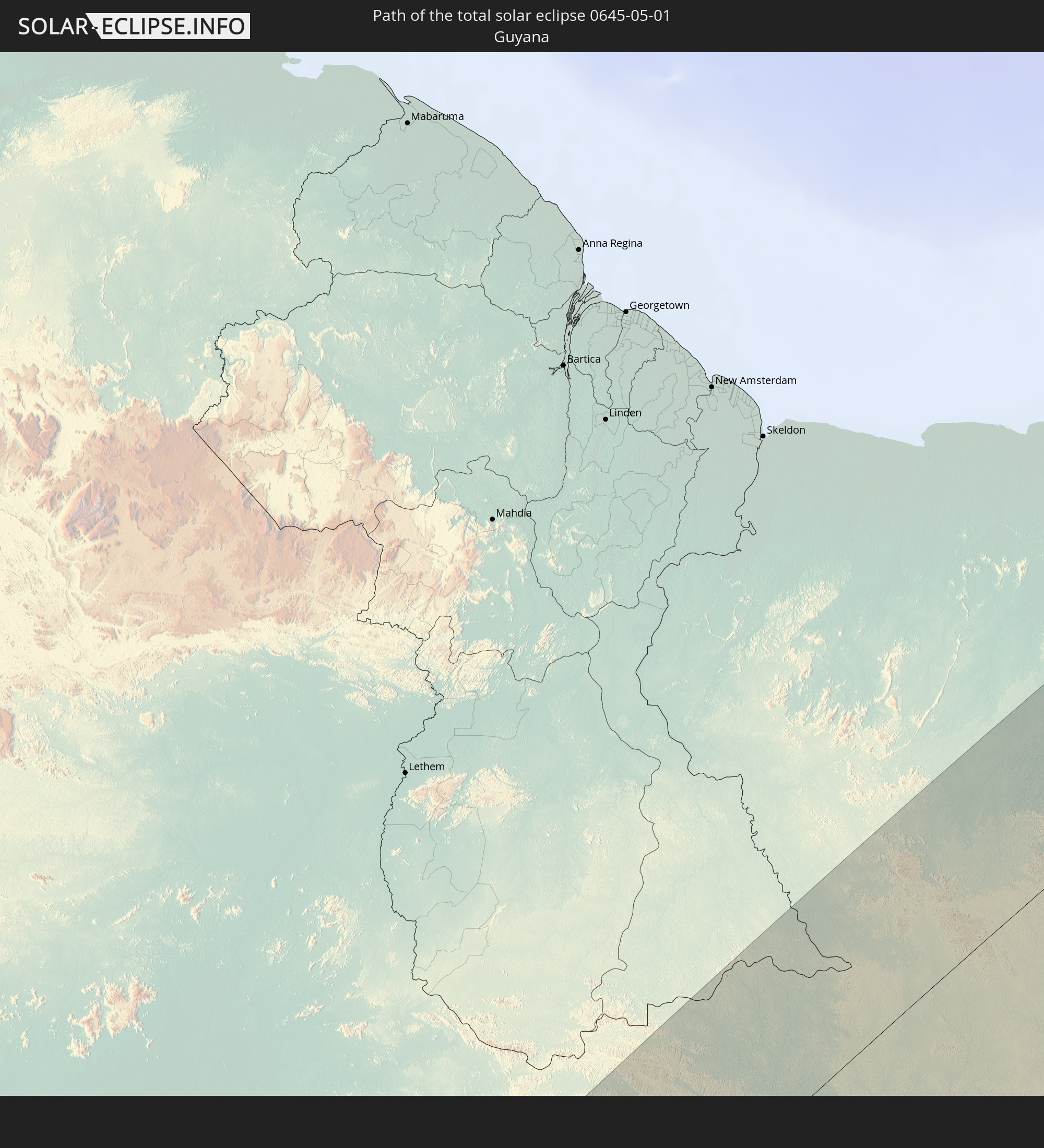 Guyana
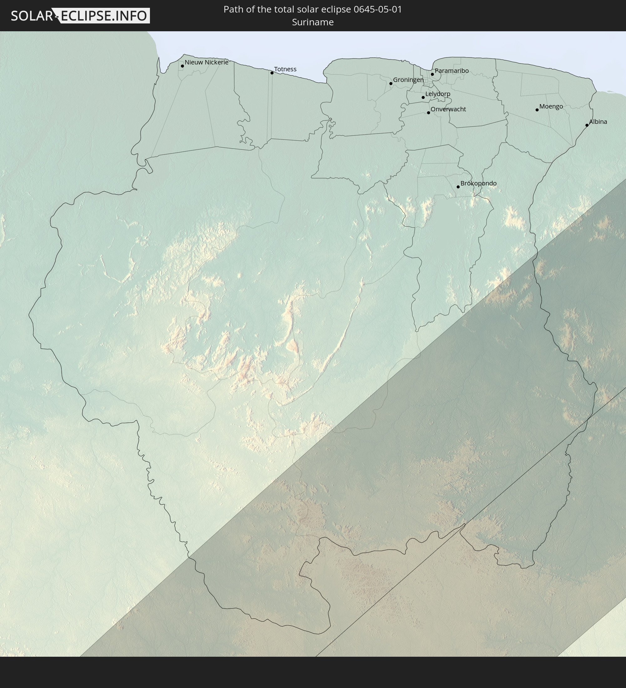 Suriname
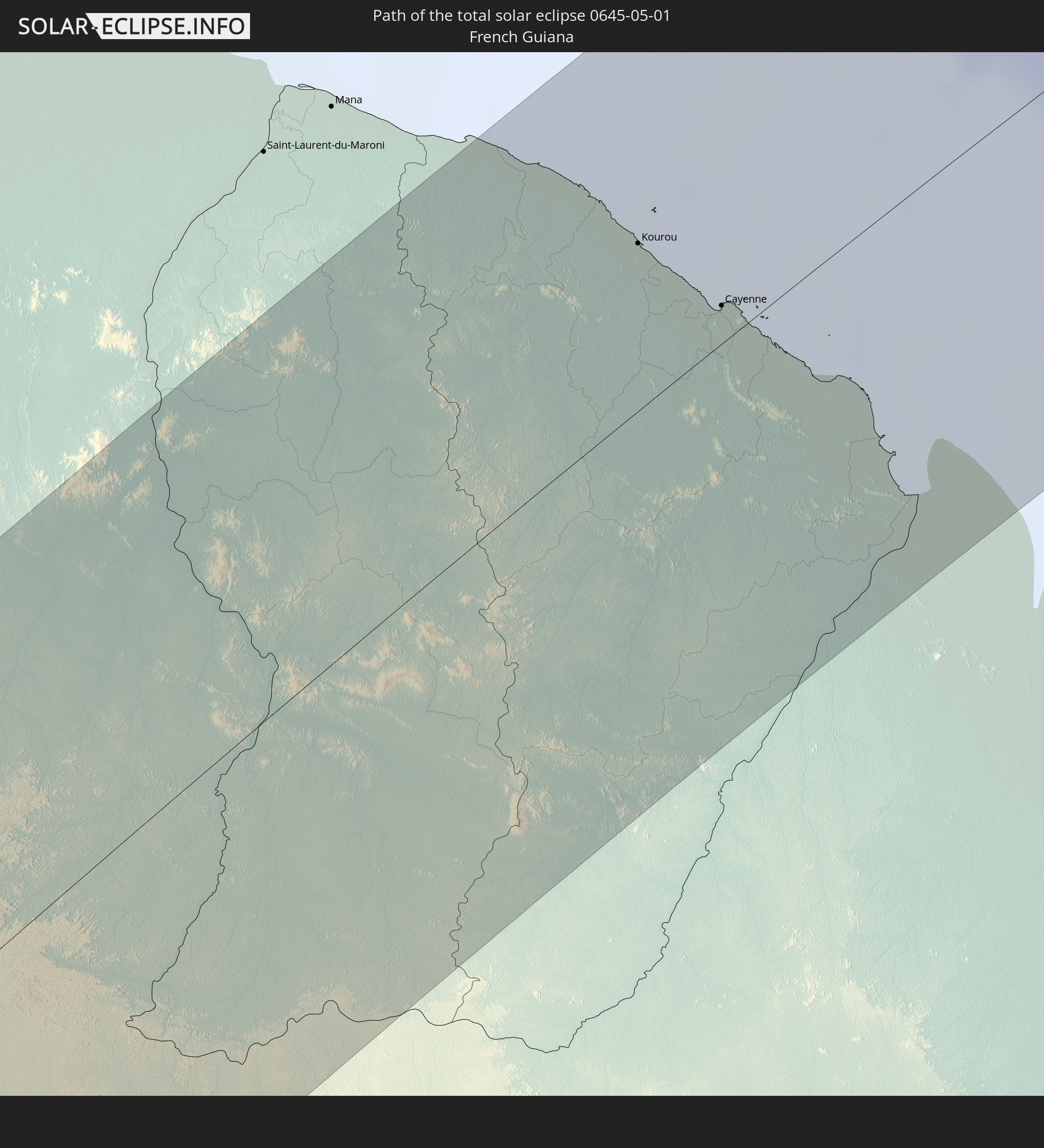 French Guiana
 Cabo Verde
 Senegal
 Mauritania
 Mali
Mali
 Burkina Faso
 Niger
Niger
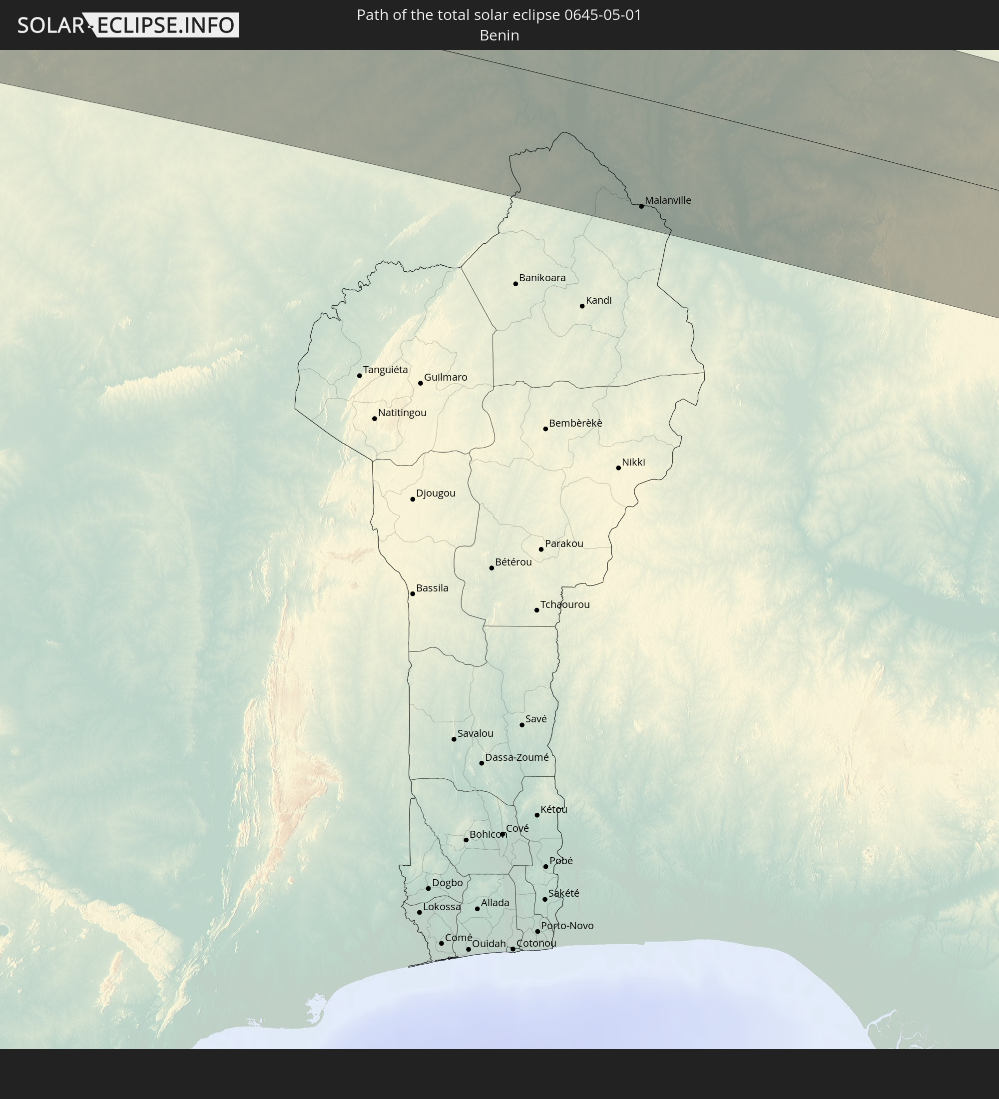 Benin
Benin
 Nigeria
In den folgenden Ländern ist die Sonnenfinsternis partiell zu sehen
 United States Minor Outlying Islands
 Chile
Chile
 Ecuador
 El Salvador
 Honduras
 Nicaragua
 Costa Rica
 Cuba
Cuba
 Panama
 Colombia
 Cayman Islands
 Peru
Peru
 The Bahamas
 Jamaica
 Haiti
Haiti
 Brazil
 Argentina
 Venezuela
 Turks and Caicos Islands
 Dominican Republic
 Aruba
Aruba
 Bolivia
 Puerto Rico
 United States Virgin Islands
 Bermuda
 British Virgin Islands
 Anguilla
 Collectivity of Saint Martin
 Saint Barthélemy
 Saint Kitts and Nevis
 Paraguay
 Antigua and Barbuda
 Montserrat
 Trinidad and Tobago
 Guadeloupe
 Grenada
 Dominica
 Saint Vincent and the Grenadines
 Guyana
 Martinique
 Saint Lucia
 Barbados
 Uruguay
 Suriname
 French Guiana
 Portugal
 Cabo Verde
 Spain
Spain
 Senegal
 Mauritania
 The Gambia
 Guinea-Bissau
 Guinea
 Saint Helena, Ascension and Tristan da Cunha
 Sierra Leone
 Morocco
 Mali
Mali
 Liberia
 Algeria
 Ivory Coast
 Burkina Faso
 Gibraltar
 France
 Ghana
Ghana
 Togo
Togo
 Niger
Niger
 Benin
Benin
 Andorra
 Nigeria
 Equatorial Guinea
 São Tomé and Príncipe
 Italy
Italy
 Monaco
 Tunisia
 Cameroon
 Libya
Libya
 Vatican City
 Malta
Malta
 Albania
 Greece
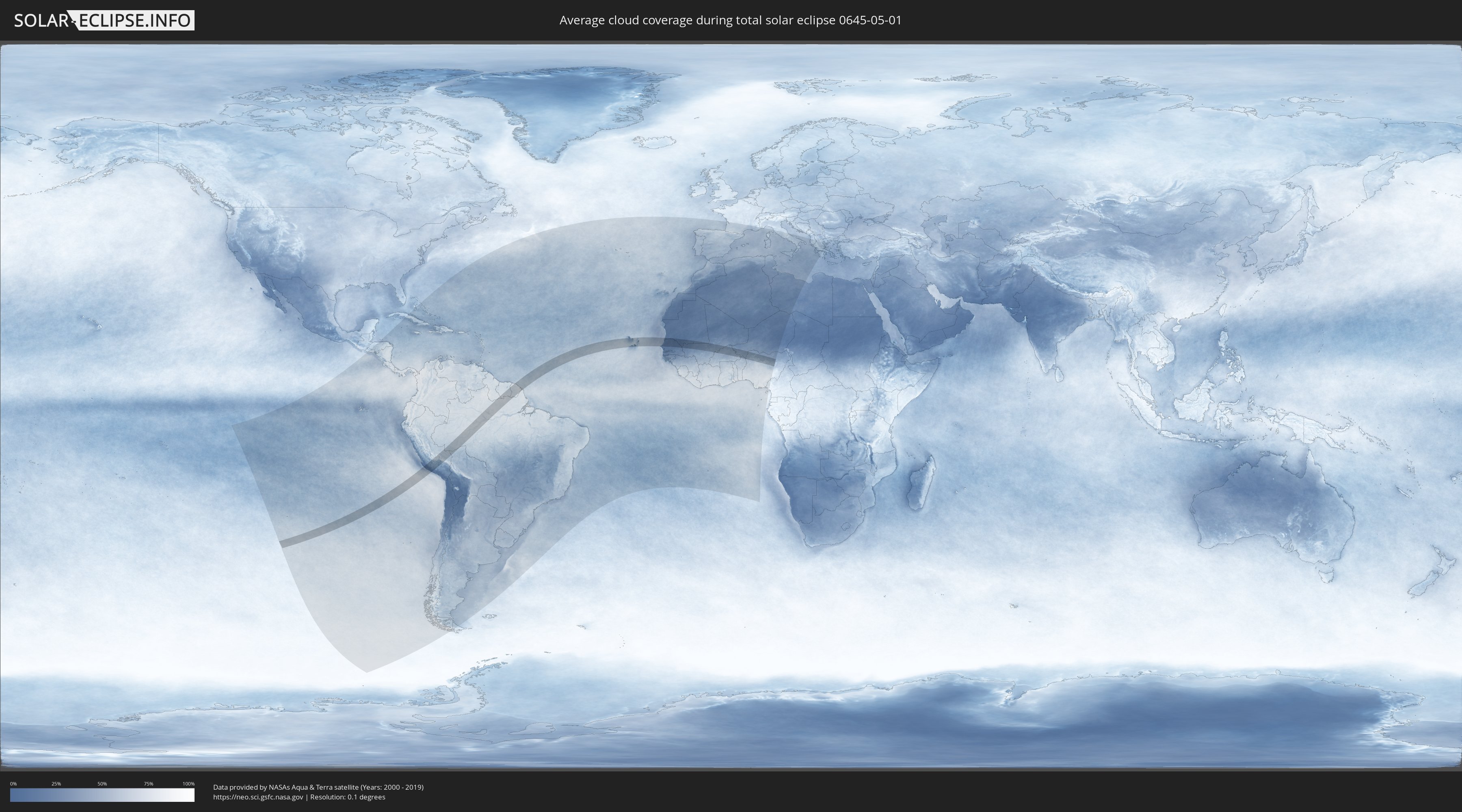
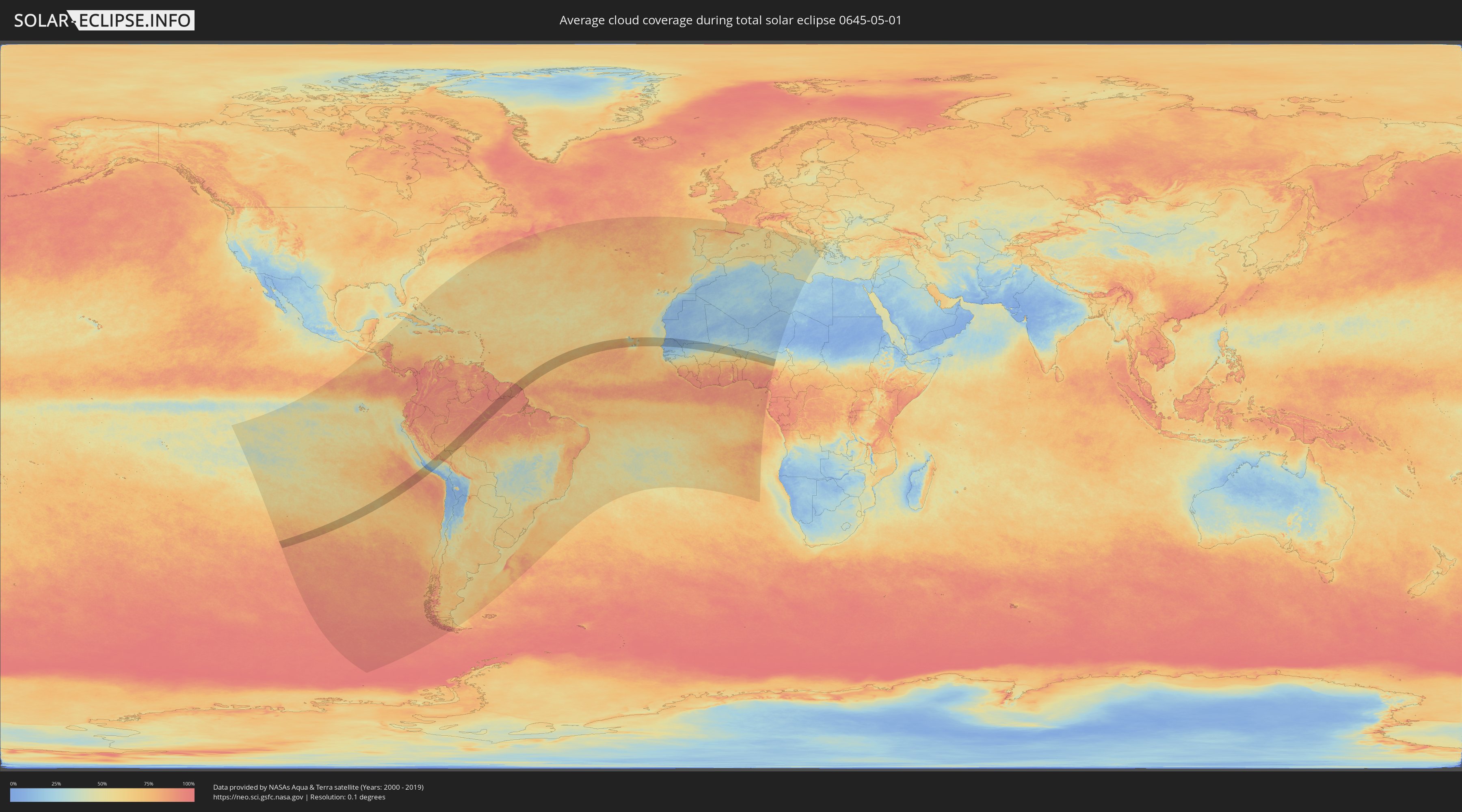
How will be the weather during the total solar eclipse on 05/01/0645?
Where is the best place to see the total solar eclipse of 05/01/0645?
The following maps show the average cloud coverage for the day of the total solar eclipse.
With the help of these maps, it is possible to find the place along the eclipse path, which has the best
chance of a cloudless sky.
Nevertheless, you should consider local circumstances and inform about the weather of your chosen
observation site.
The data is provided by NASAs satellites
AQUA and TERRA.
The cloud maps are averaged over a period of 19 years (2000 - 2019).
Detailed country maps
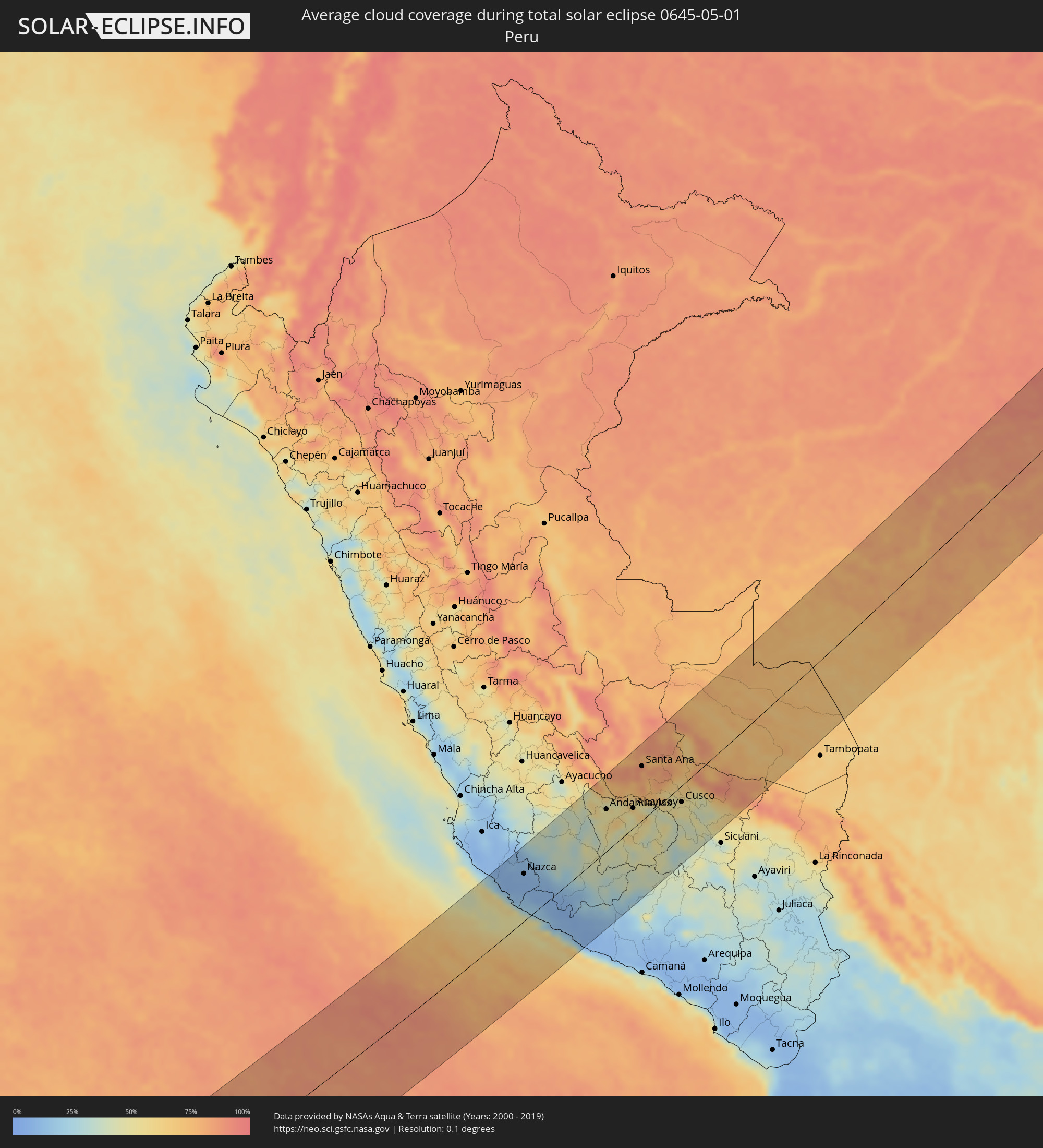 Peru
Peru
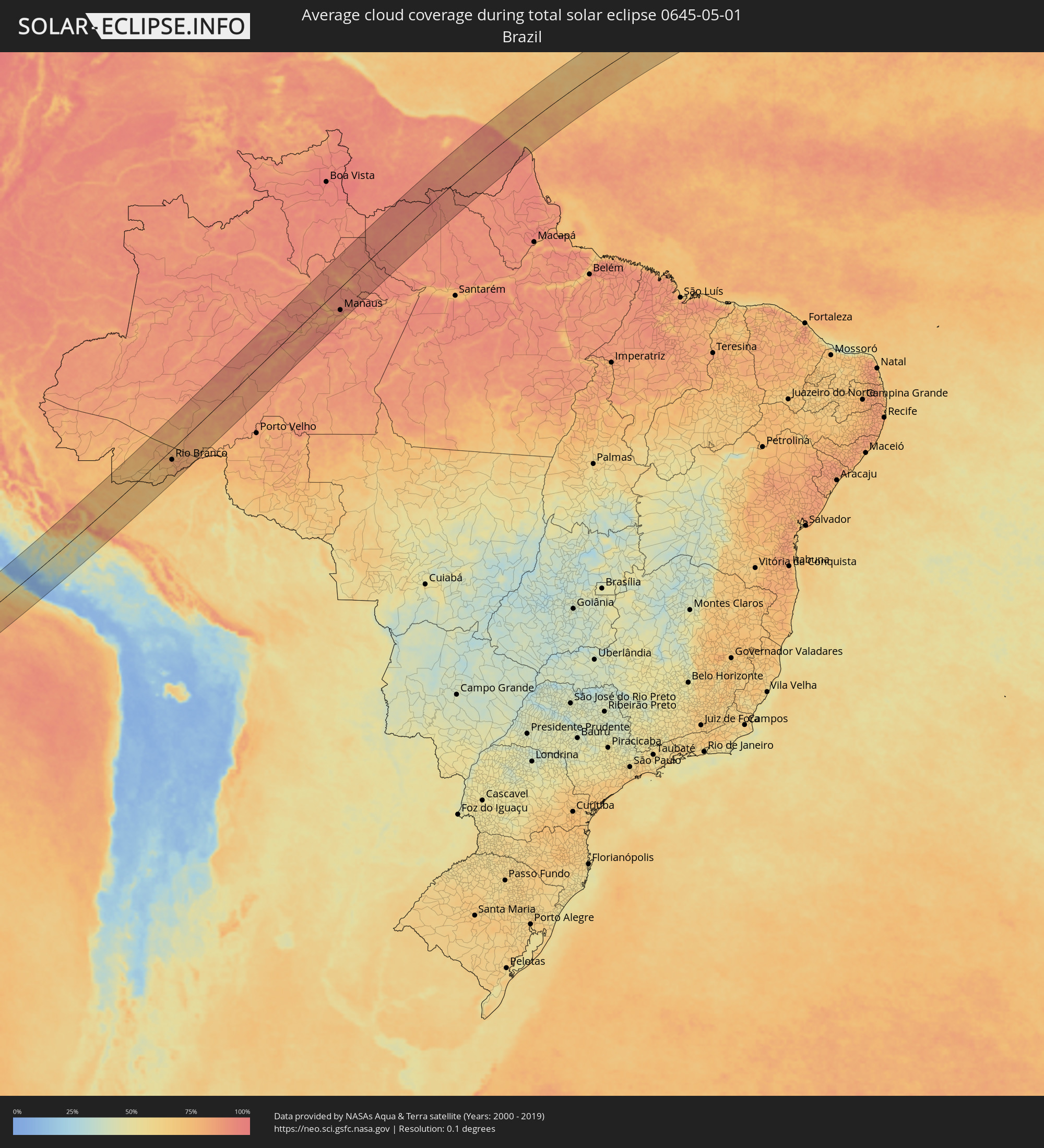 Brazil
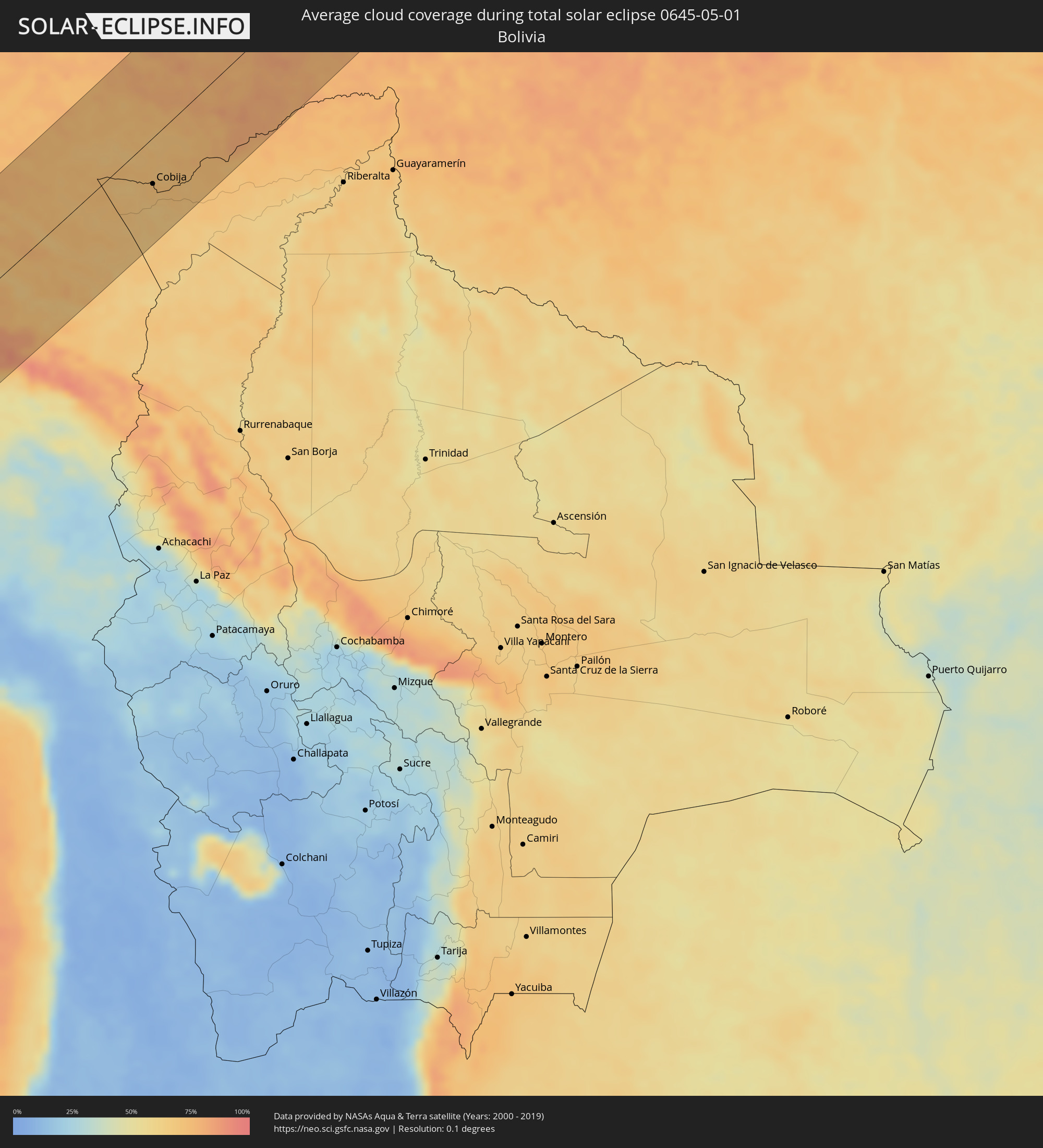 Bolivia
 Guyana
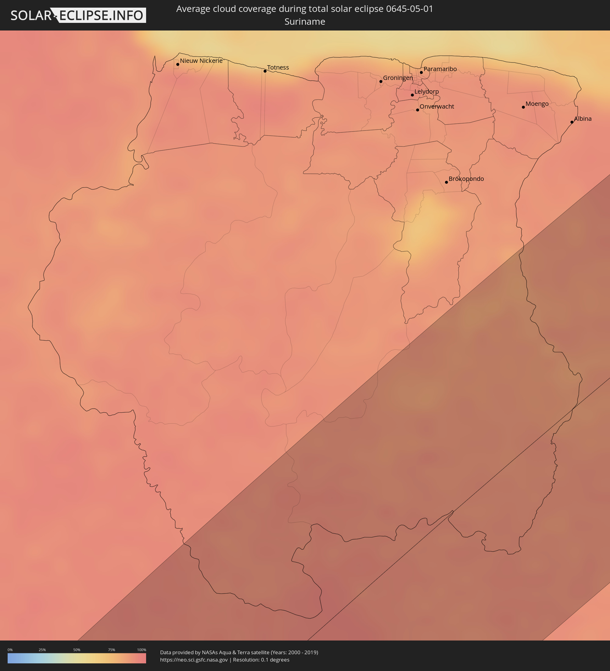 Suriname
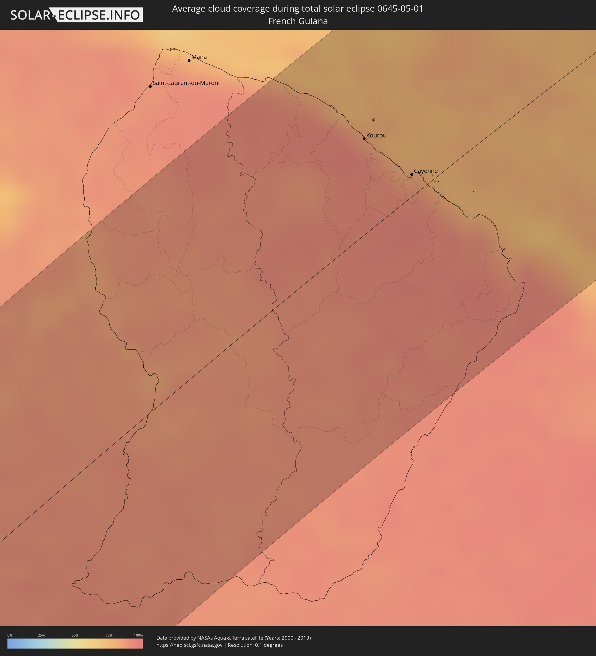 French Guiana
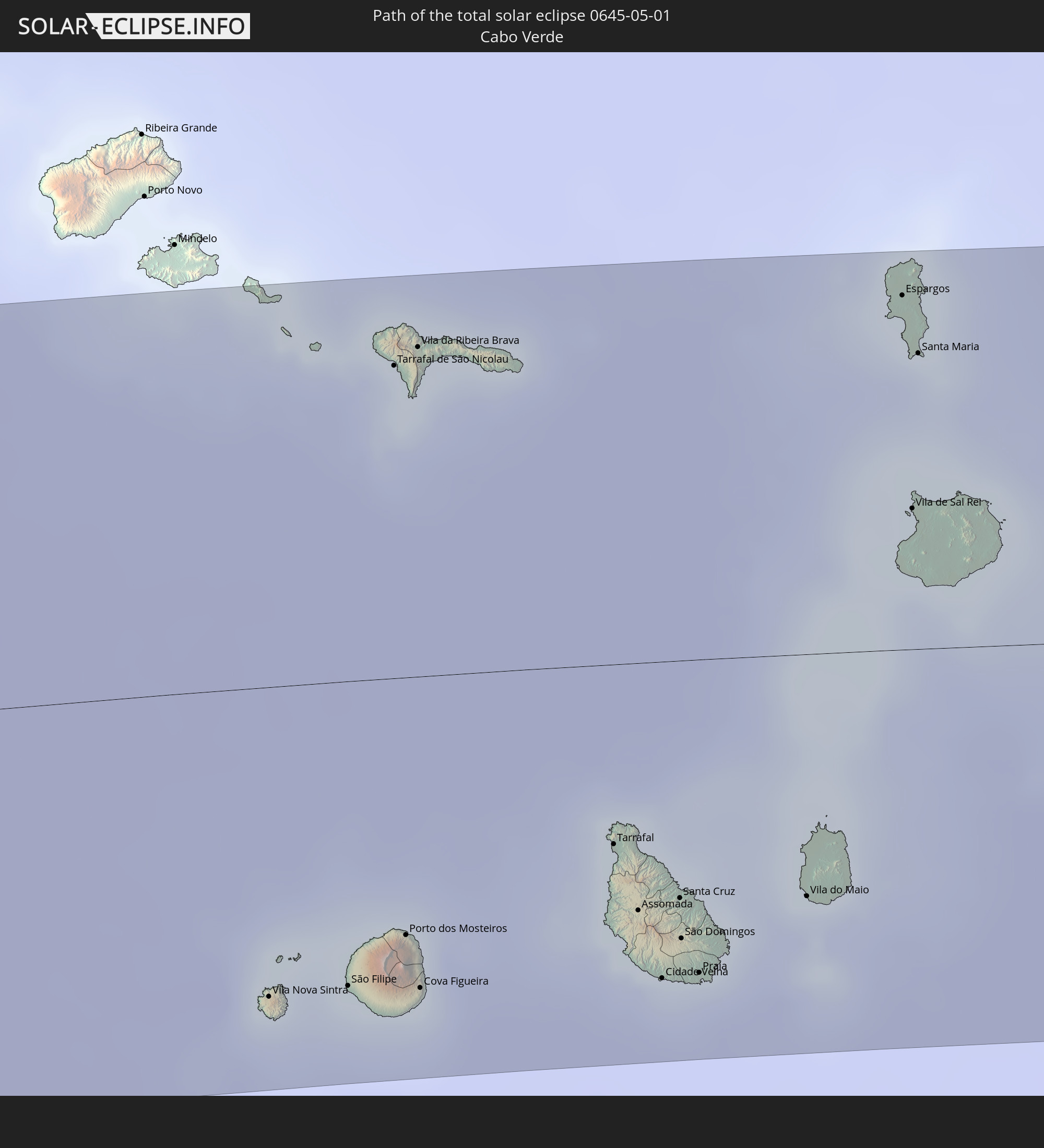
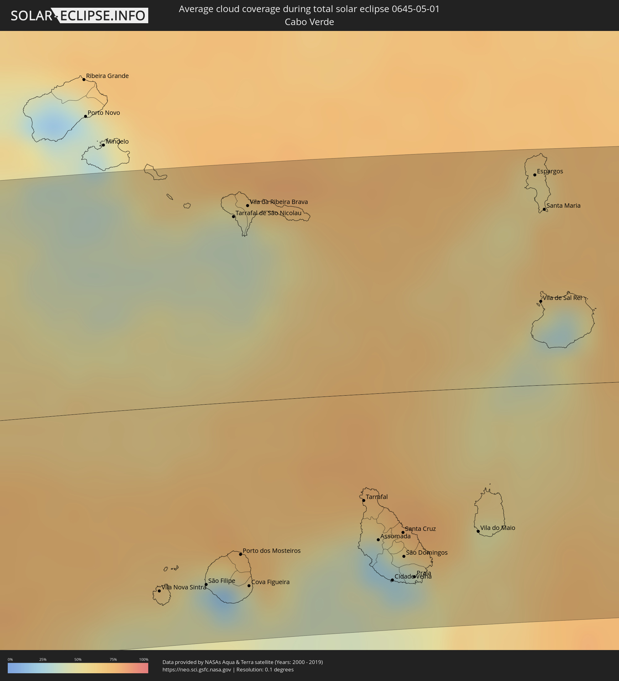 Cabo Verde
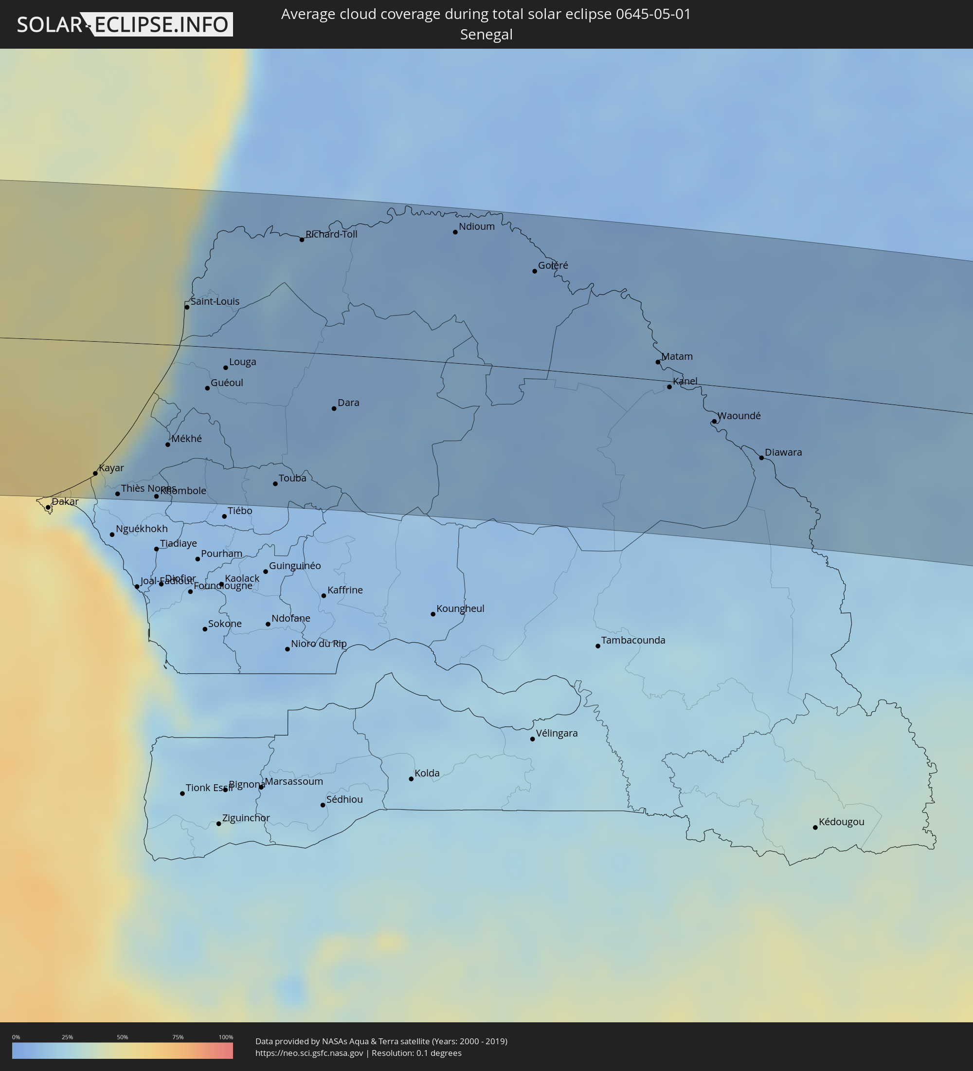 Senegal
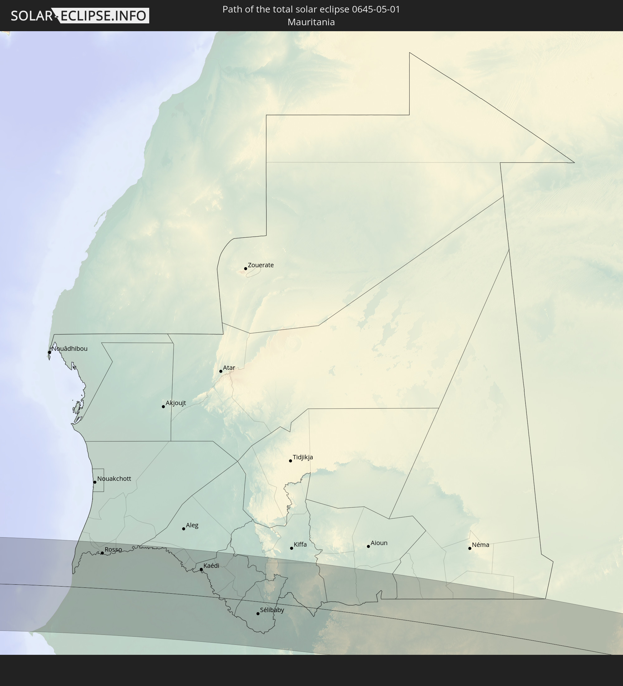
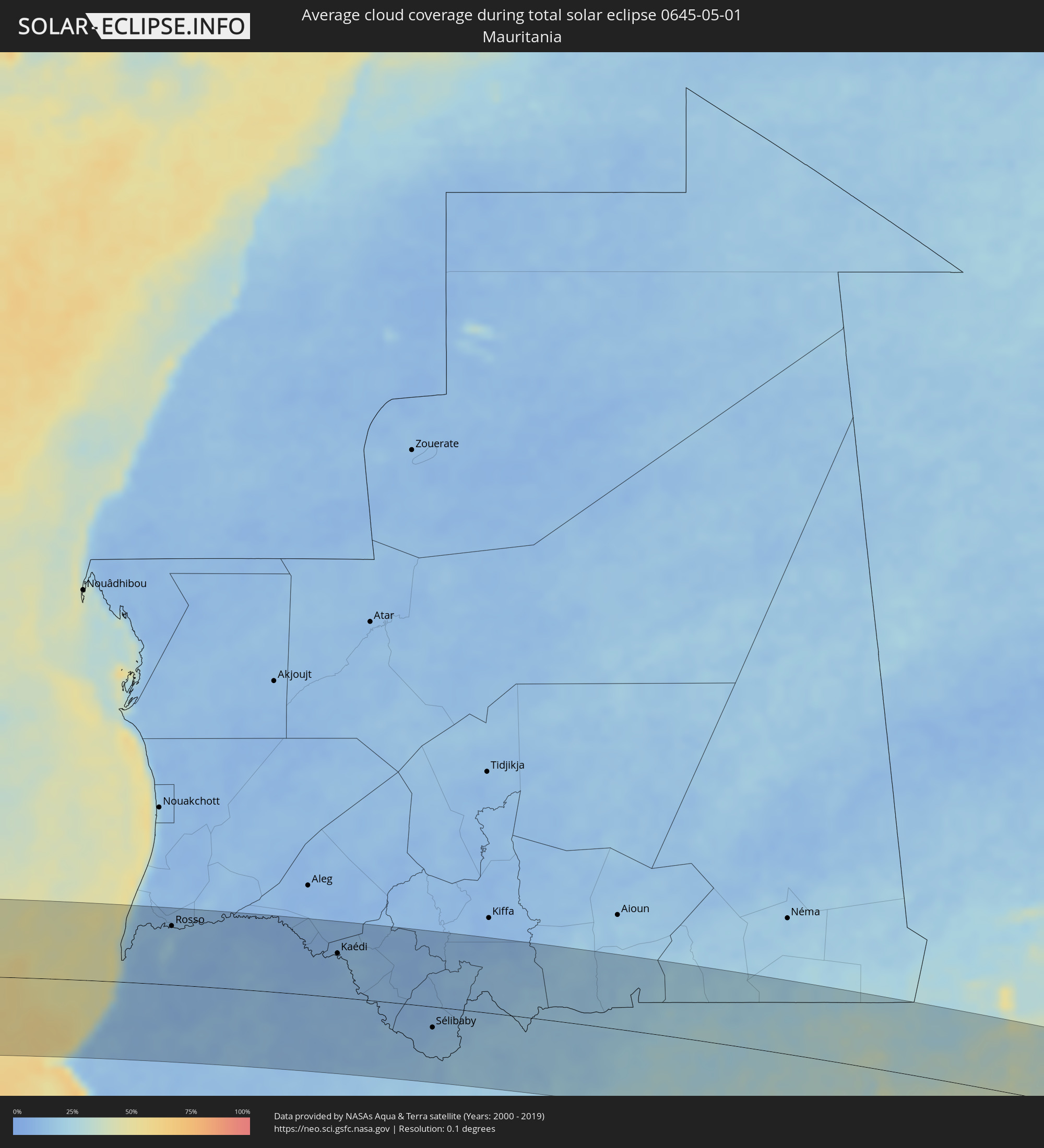 Mauritania
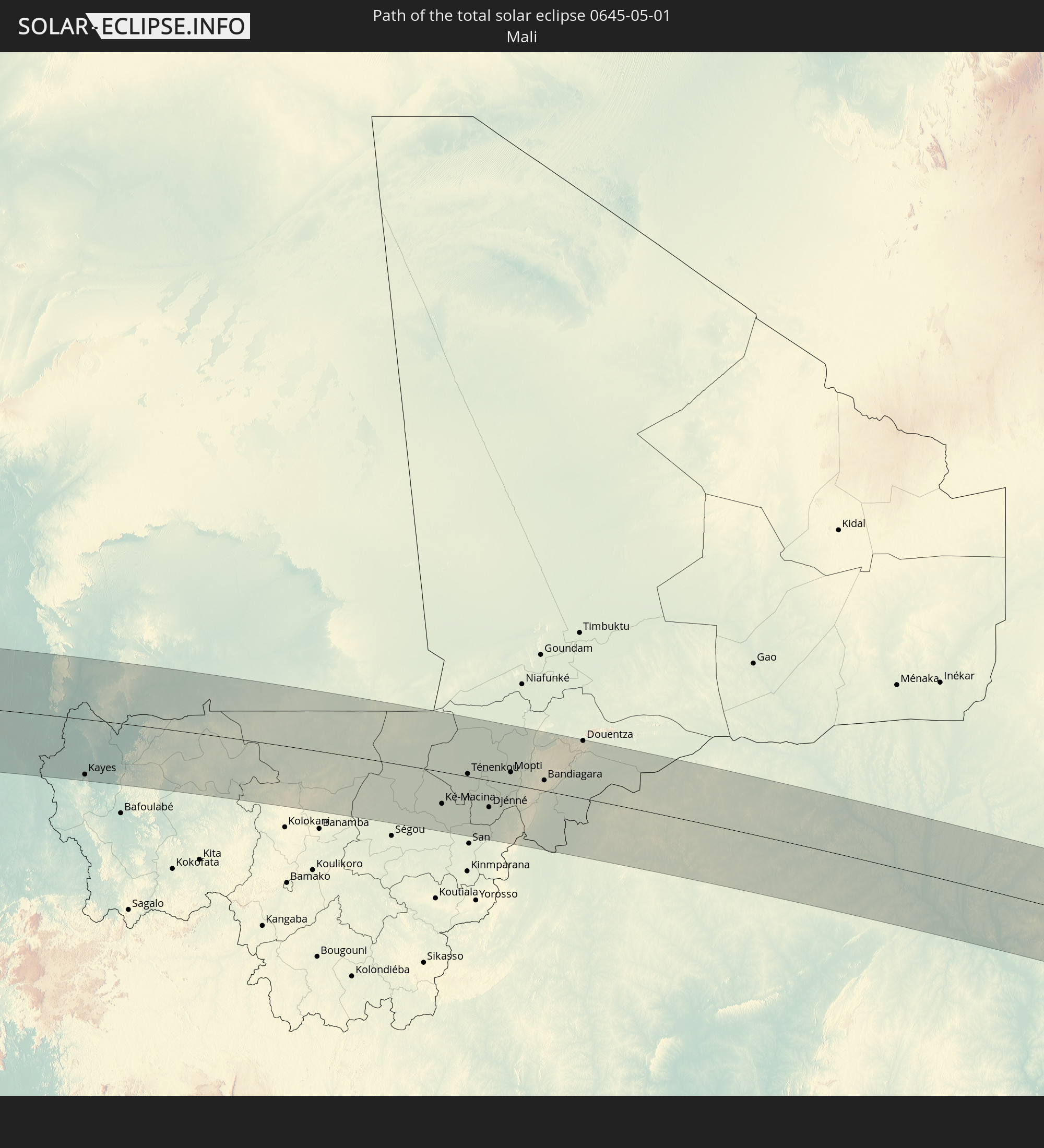
 Mali
Mali
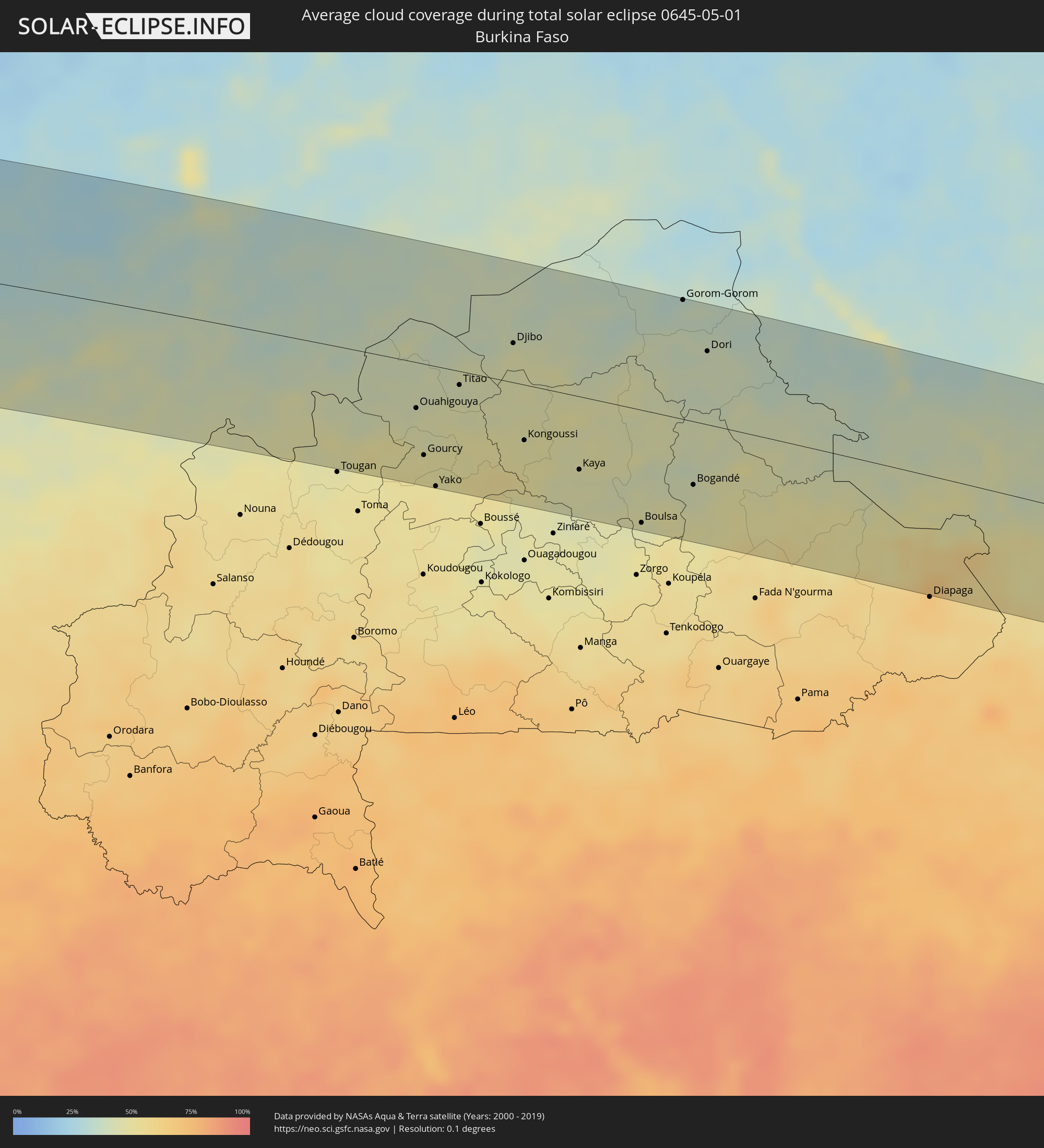 Burkina Faso
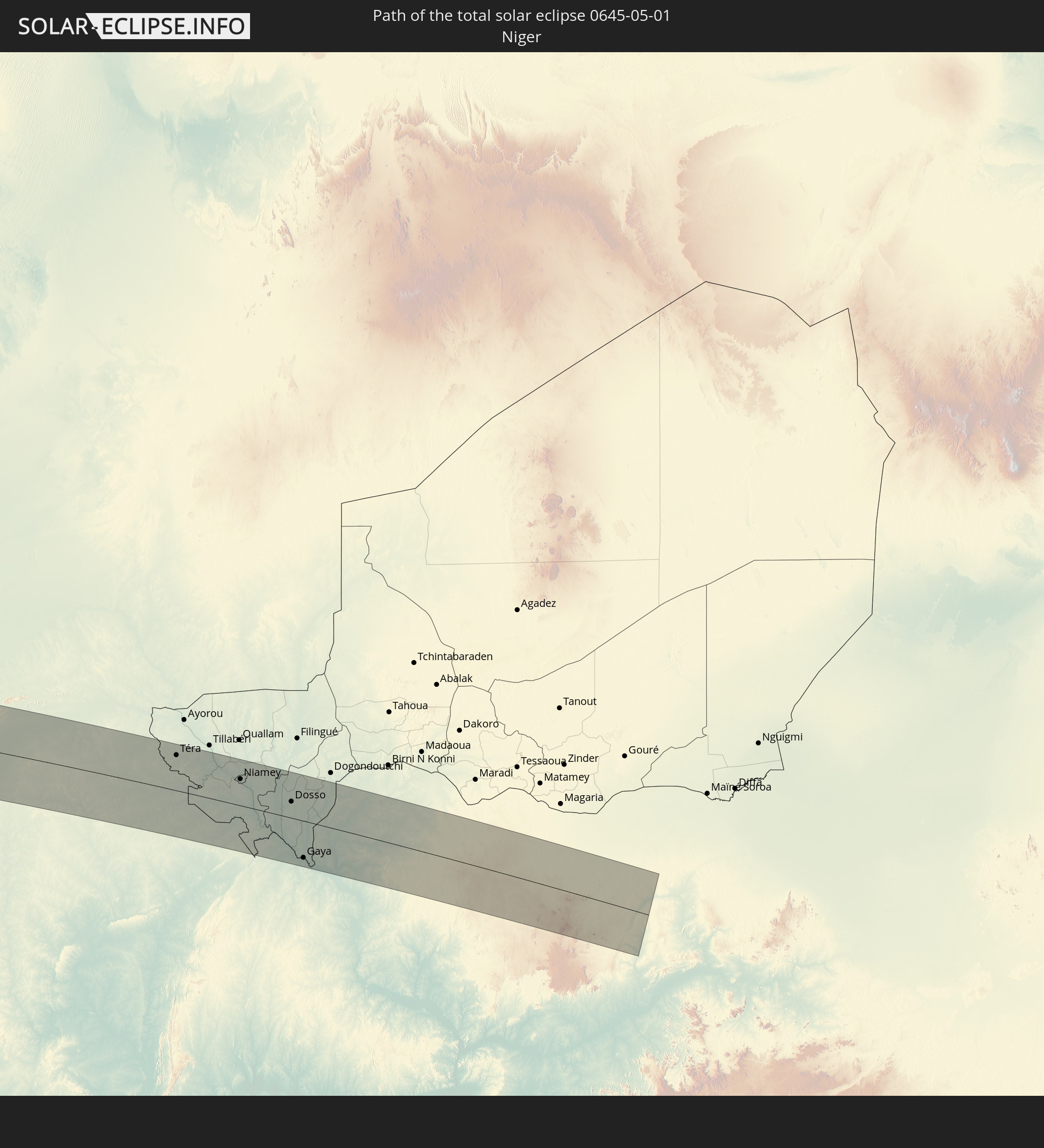
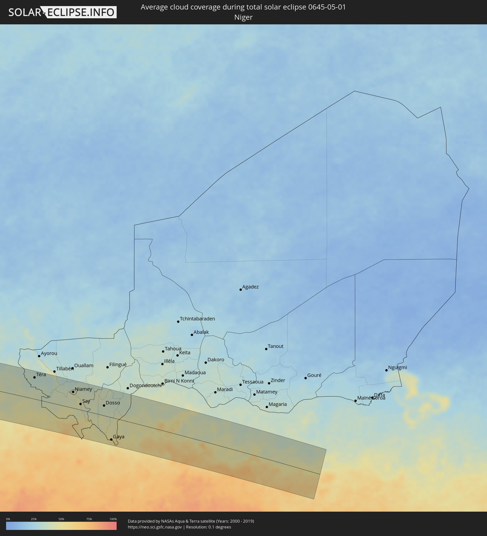 Niger
Niger
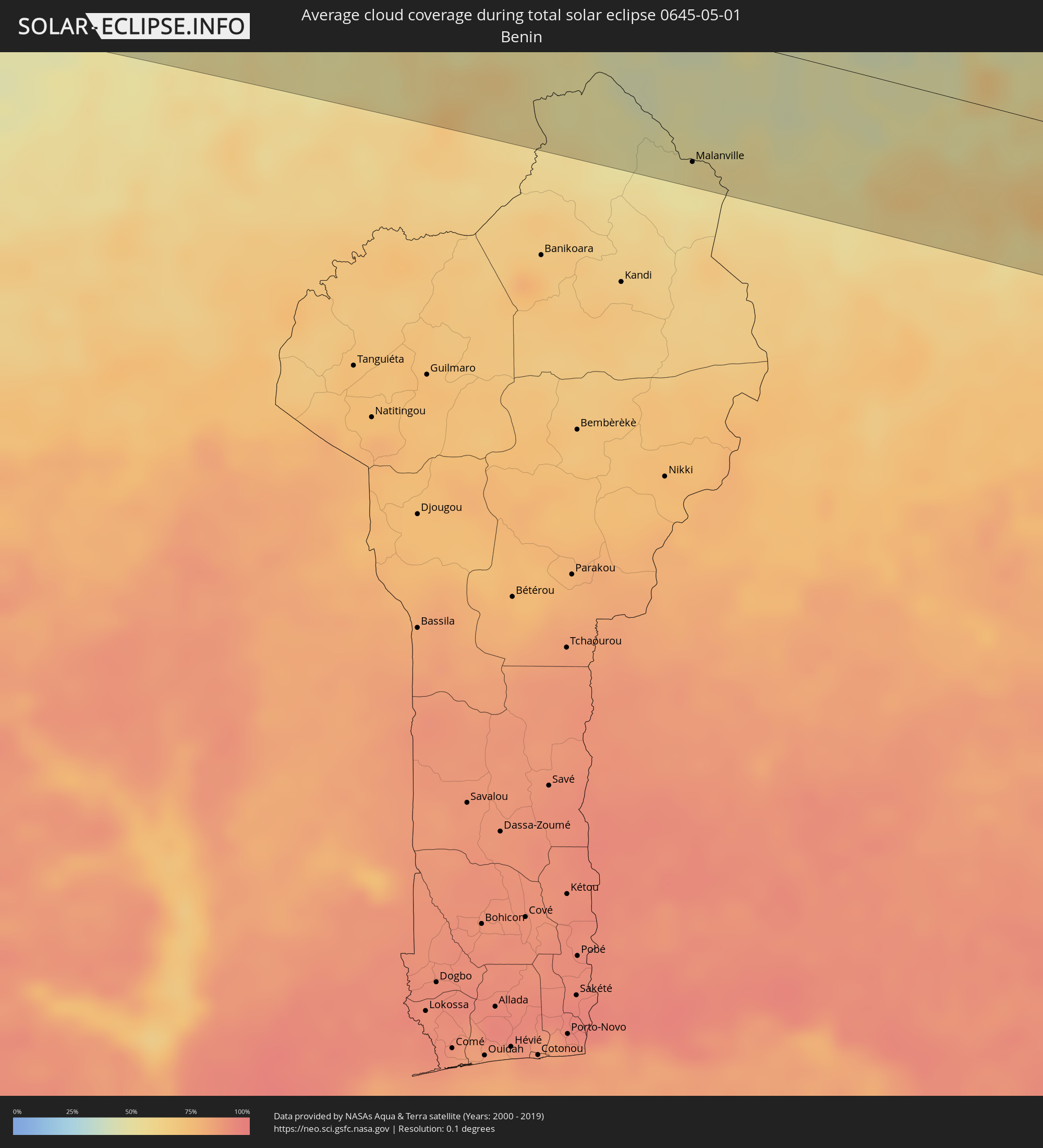 Benin
Benin
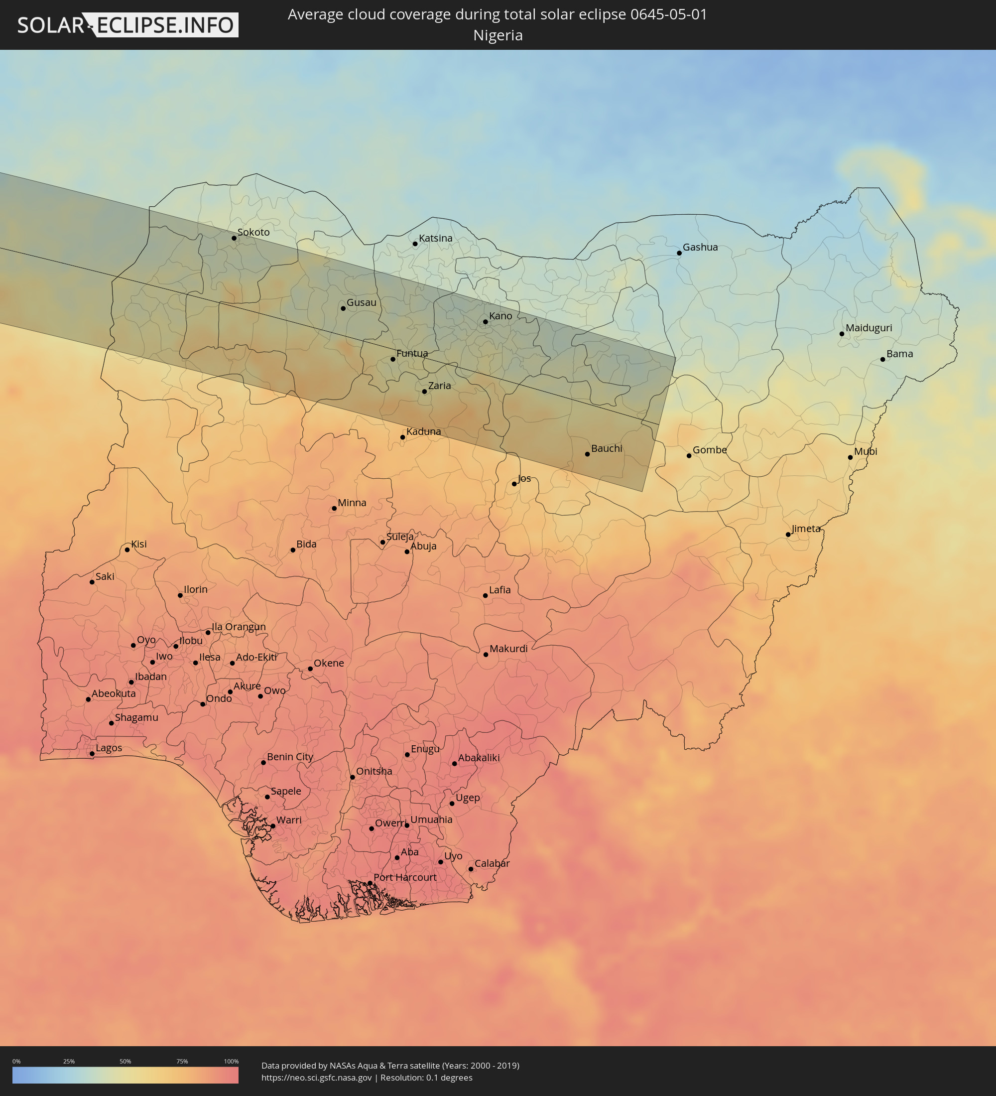 Nigeria
Cities inside the path of the eclipse
The following table shows all locations with a population of more than 5,000 inside the eclipse path. Cities which have more than 100,000 inhabitants are marked bold. A click at the locations opens a detailed map.
| City | Type | Eclipse duration | Local time of max. eclipse | Distance to central line | Ø Cloud coverage |
|
Palpa, Ica
|
total | - | 09:23:53 UTC-05:08 | 116 km | 11% |
|
Minas de Marcona, Ica
|
total | - | 09:23:15 UTC-05:08 | 53 km | 13% |
|
Nazca, Ica
|
total | - | 09:23:52 UTC-05:08 | 74 km | 9% |
|
Puquio, Ayacucho
|
total | - | 09:25:02 UTC-05:08 | 29 km | 25% |
|
Tambo, Ayacucho
|
total | - | 09:25:11 UTC-05:08 | 6 km | 36% |
|
Coracora, Ayacucho
|
total | - | 09:25:07 UTC-05:08 | 24 km | 22% |
|
Talavera, Apurímac
|
total | - | 09:27:07 UTC-05:08 | 68 km | 49% |
|
Andahuaylas, Apurímac
|
total | - | 09:27:10 UTC-05:08 | 65 km | 49% |
|
San Jerónimo, Apurímac
|
total | - | 09:27:12 UTC-05:08 | 63 km | 49% |
|
Abancay, Apurímac
|
total | - | 09:27:52 UTC-05:08 | 31 km | 50% |
|
Santa Ana, Cusco
|
total | - | 09:29:00 UTC-05:08 | 83 km | 80% |
|
Anta, Cusco
|
total | - | 09:29:03 UTC-05:08 | 8 km | 54% |
|
Urubamba, Cusco
|
total | - | 09:29:18 UTC-05:08 | 4 km | 47% |
|
Cusco, Cusco
|
total | - | 09:29:15 UTC-05:08 | 25 km | 51% |
|
Calca, Cusco
|
total | - | 09:29:30 UTC-05:08 | 11 km | 55% |
|
Urcos, Cusco
|
total | - | 09:29:32 UTC-05:08 | 63 km | 41% |
|
Cobija, Pando
|
total | - | 10:13:03 UTC-04:32 | 53 km | 72% |
|
Brasiléia, Acre
|
total | - | 10:13:06 UTC-04:32 | 53 km | 73% |
|
Sena Madureira, Acre
|
total | - | 10:17:19 UTC-04:31 | 100 km | 80% |
|
Rio Branco, Acre
|
total | - | 10:17:24 UTC-04:31 | 38 km | 79% |
|
Senador Guiomard, Acre
|
total | - | 10:17:16 UTC-04:31 | 58 km | 78% |
|
Boca do Acre, Amazonas
|
total | - | 10:48:20 UTC-04:02 | 30 km | 76% |
|
Plácido de Castro, Acre
|
total | - | 10:16:29 UTC-04:32 | 115 km | 77% |
|
Pauini, Amazonas
|
total | - | 10:50:33 UTC-04:02 | 81 km | 80% |
|
Canutama, Amazonas
|
total | - | 10:56:50 UTC-04:02 | 22 km | 80% |
|
Coari, Amazonas
|
total | - | 11:03:03 UTC-04:02 | 78 km | 86% |
|
Codajás, Amazonas
|
total | - | 11:05:31 UTC-04:02 | 14 km | 86% |
|
Anori, Amazonas
|
total | - | 11:06:25 UTC-04:02 | 13 km | 88% |
|
Manacapuru, Amazonas
|
total | - | 11:09:13 UTC-04:02 | 54 km | 79% |
|
Manaquiri, Amazonas
|
total | - | 11:09:43 UTC-04:02 | 76 km | 79% |
|
Iranduba, Amazonas
|
total | - | 11:10:06 UTC-04:02 | 86 km | 81% |
|
Manaus, Amazonas
|
total | - | 11:10:44 UTC-04:02 | 84 km | 89% |
|
Careiro da Várzea, Amazonas
|
total | - | 11:10:58 UTC-04:02 | 107 km | 80% |
|
Rio Preto da Eva, Amazonas
|
total | - | 11:12:05 UTC-04:02 | 76 km | 90% |
|
Kourou, Guyane
|
total | - | 12:14:50 UTC-03:29 | 54 km | 82% |
|
Macouria, Guyane
|
total | - | 12:15:00 UTC-03:29 | 13 km | 88% |
|
Cayenne, Guyane
|
total | - | 12:15:08 UTC-03:29 | 12 km | 87% |
|
Matoury, Guyane
|
total | - | 12:15:00 UTC-03:29 | 4 km | 92% |
|
Rémire-Montjoly, Guyane
|
total | - | 12:15:16 UTC-03:29 | 6 km | 87% |
|
São Filipe, São Filipe
|
total | - | 15:24:13 UTC-01:34 | 91 km | 42% |
|
Tarrafal de São Nicolau, Tarrafal de São Nicolau
|
total | - | 15:25:19 UTC-01:34 | 93 km | 40% |
|
Vila da Ribeira Brava, Ribeira Brava
|
total | - | 15:25:27 UTC-01:34 | 98 km | 40% |
|
Cova Figueira, Santa Catarina do Fogo
|
total | - | 15:24:32 UTC-01:34 | 93 km | 40% |
|
Tarrafal, Tarrafal
|
total | - | 15:25:36 UTC-01:34 | 54 km | 57% |
|
Assomada, Santa Catarina
|
total | - | 15:25:37 UTC-01:34 | 74 km | 25% |
|
Picos, São Salvador do Mundo
|
total | - | 15:25:41 UTC-01:34 | 76 km | 29% |
|
Cidade Velha, Ribeira Grande de Santiago
|
total | - | 15:25:37 UTC-01:34 | 95 km | 44% |
|
Calheta, São Miguel
|
total | - | 15:25:48 UTC-01:34 | 65 km | 49% |
|
Santa Cruz, Santa Cruz
|
total | - | 15:25:48 UTC-01:34 | 71 km | 29% |
|
São Domingos, São Domingos
|
total | - | 15:25:45 UTC-01:34 | 83 km | 30% |
|
Pedra Badejo, Santa Cruz
|
total | - | 15:25:52 UTC-01:34 | 71 km | 42% |
|
Praia, Praia
|
total | - | 15:25:47 UTC-01:34 | 94 km | 47% |
|
Vila do Maio, Maio
|
total | - | 15:26:21 UTC-01:34 | 73 km | 56% |
|
Espargos, Sal
|
total | - | 15:27:33 UTC-01:34 | 106 km | 54% |
|
Vila de Sal Rei, Boa Vista
|
total | - | 15:27:19 UTC-01:34 | 42 km | 48% |
|
Santa Maria, Sal
|
total | - | 15:27:33 UTC-01:34 | 88 km | 69% |
|
N’diareme limamoulaye, Dakar
|
total | - | 16:52:12 UTC-00:16 | 114 km | 45% |
|
Kayar, Thiès
|
total | - | 16:52:35 UTC-00:16 | 98 km | 22% |
|
Pout, Thiès
|
total | - | 16:52:36 UTC-00:16 | 114 km | 16% |
|
Thiès Nones, Thiès
|
total | - | 16:52:43 UTC-00:16 | 112 km | 13% |
|
Khombole, Thiès
|
total | - | 16:53:02 UTC-00:16 | 112 km | 13% |
|
Mékhé, Thiès
|
total | - | 16:53:15 UTC-00:16 | 74 km | 15% |
|
Saint-Louis, Saint-Louis
|
total | - | 16:53:42 UTC-00:16 | 28 km | 37% |
|
Guéoul, Louga
|
total | - | 16:53:42 UTC-00:16 | 31 km | 12% |
|
Louga, Louga
|
total | - | 16:53:53 UTC-00:16 | 15 km | 12% |
|
Touba, Diourbel
|
total | - | 16:54:02 UTC-00:16 | 98 km | 13% |
|
Rosso, Trarza
|
total | - | 16:54:37 UTC-00:16 | 87 km | 16% |
|
Richard-Toll, Saint-Louis
|
total | - | 16:54:43 UTC-00:16 | 82 km | 16% |
|
Dara, Louga
|
total | - | 16:54:39 UTC-00:16 | 40 km | 12% |
|
Ndibène Dahra, Louga
|
total | - | 16:54:39 UTC-00:16 | 42 km | 12% |
|
Tékane, Trarza
|
total | - | 16:55:01 UTC-00:16 | 97 km | 14% |
|
Ndioum, Saint-Louis
|
total | - | 16:55:53 UTC-00:16 | 95 km | 8% |
|
Kaédi, Gorgol
|
total | - | 16:56:58 UTC-00:16 | 65 km | 12% |
|
Ouro Sogui, Matam
|
total | - | 16:57:01 UTC-00:16 | 7 km | 12% |
|
Matam, Matam
|
total | - | 16:57:06 UTC-00:16 | 13 km | 12% |
|
Kanel, Matam
|
total | - | 16:57:08 UTC-00:16 | 5 km | 11% |
|
Sélibaby, Guidimaka
|
total | - | 16:58:02 UTC-00:16 | 31 km | 13% |
|
Kayes, Kayes
|
total | - | 16:58:33 UTC-00:16 | 101 km | 20% |
|
Markala, Ségou
|
total | - | 17:02:45 UTC-00:16 | 100 km | 43% |
|
Ké-Macina, Ségou
|
total | - | 17:03:16 UTC-00:16 | 58 km | 41% |
|
Ténenkou, Mopti
|
total | - | 17:03:38 UTC-00:16 | 5 km | 36% |
|
Djénné, Mopti
|
total | - | 17:03:46 UTC-00:16 | 49 km | 42% |
|
Mopti, Mopti
|
total | - | 17:04:05 UTC-00:16 | 22 km | 40% |
|
Bandiagara, Mopti
|
total | - | 17:04:24 UTC-00:16 | 19 km | 36% |
|
Douentza, Mopti
|
total | - | 17:04:51 UTC-00:16 | 104 km | 35% |
|
Ouahigouya, Nord
|
total | - | 17:04:56 UTC-00:16 | 40 km | 45% |
|
Gourcy, Nord
|
total | - | 17:04:54 UTC-00:16 | 79 km | 50% |
|
Yako, Nord
|
total | - | 17:04:54 UTC-00:16 | 104 km | 51% |
|
Titao, Nord
|
total | - | 17:05:08 UTC-00:16 | 12 km | 43% |
|
Djibo, Sahel
|
total | - | 17:05:24 UTC-00:16 | 34 km | 46% |
|
Kongoussi, Centre-Nord
|
total | - | 17:05:20 UTC-00:16 | 48 km | 48% |
|
Kaya, Centre-Nord
|
total | - | 17:05:31 UTC-00:16 | 64 km | 45% |
|
Boulsa, Centre-Nord
|
total | - | 17:05:41 UTC-00:16 | 98 km | 44% |
|
Gorom-Gorom, Sahel
|
total | - | 17:06:05 UTC-00:16 | 103 km | 36% |
|
Bogandé, Est
|
total | - | 17:05:55 UTC-00:16 | 55 km | 43% |
|
Dori, Sahel
|
total | - | 17:06:07 UTC-00:16 | 63 km | 40% |
|
Téra, Tillabéri
|
total | - | 17:36:09 UTC+00:13 | 79 km | 34% |
|
Niamey, Niamey
|
total | - | 17:36:35 UTC+00:13 | 59 km | 44% |
|
Kollo, Tillabéri
|
total | - | 17:36:38 UTC+00:13 | 42 km | 46% |
|
Say, Tillabéri
|
total | - | 17:36:37 UTC+00:13 | 21 km | 44% |
|
Dosso, Dosso
|
total | - | 17:36:53 UTC+00:13 | 37 km | 39% |
|
Malanville, Atakora
|
total | - | 17:36:46 UTC+00:13 | 86 km | 53% |
|
Gaya, Dosso
|
total | - | 17:36:47 UTC+00:13 | 83 km | 53% |
|
Kamba, Kebbi
|
total | - | 17:36:50 UTC+00:13 | 81 km | 54% |
|
Birnin Kebbi, Kebbi
|
total | - | 17:37:05 UTC+00:13 | 1 km | 46% |
|
Jega, Kebbi
|
total | - | 17:37:06 UTC+00:13 | 21 km | 47% |
|
Argungu, Kebbi
|
total | - | 17:37:12 UTC+00:13 | 39 km | 43% |
|
Gummi, Zamfara
|
total | - | 17:37:16 UTC+00:13 | 10 km | 53% |
|
Zuru, Kebbi
|
total | - | 17:37:11 UTC+00:13 | 83 km | 59% |
|
Sokoto, Sokoto
|
total | - | 17:37:25 UTC+00:13 | 93 km | 43% |
|
Talata Mafara, Zamfara
|
total | - | 17:37:32 UTC+00:13 | 62 km | 46% |
|
Kaura Namoda, Zamfara
|
total | - | 17:37:38 UTC+00:13 | 80 km | 41% |
|
Gusau, Zamfara
|
total | - | 17:37:35 UTC+00:13 | 36 km | 42% |
|
Funtua, Katsina
|
total | - | 17:37:37 UTC+00:13 | 15 km | 48% |
|
Malumfashi, Katsina
|
total | - | 17:37:42 UTC+00:13 | 23 km | 46% |
|
Zaria, Kaduna
|
total | - | 17:37:36 UTC+00:13 | 47 km | 56% |
|
Kano, Kano
|
total | - | 17:37:50 UTC+00:13 | 72 km | 42% |
|
Birnin Kudu, Jigawa
|
total | - | 17:37:52 UTC+00:13 | 42 km | 44% |
|
Bauchi, Bauchi
|
total | - | 17:37:43 UTC+00:13 | 70 km | 62% |
|
Azare, Bauchi
|
total | - | 17:37:56 UTC+00:13 | 87 km | 37% |