Annular solar eclipse of 03/20/0657
| Day of week: | Friday |
| Maximum duration of eclipse: | 06m56s |
| Maximum width of eclipse path: | 332 km |
| Saros cycle: | 98 |
| Coverage: | 93.5% |
| Magnitude: | 0.935 |
| Gamma: | -0.6929 |
Wo kann man die Sonnenfinsternis vom 03/20/0657 sehen?
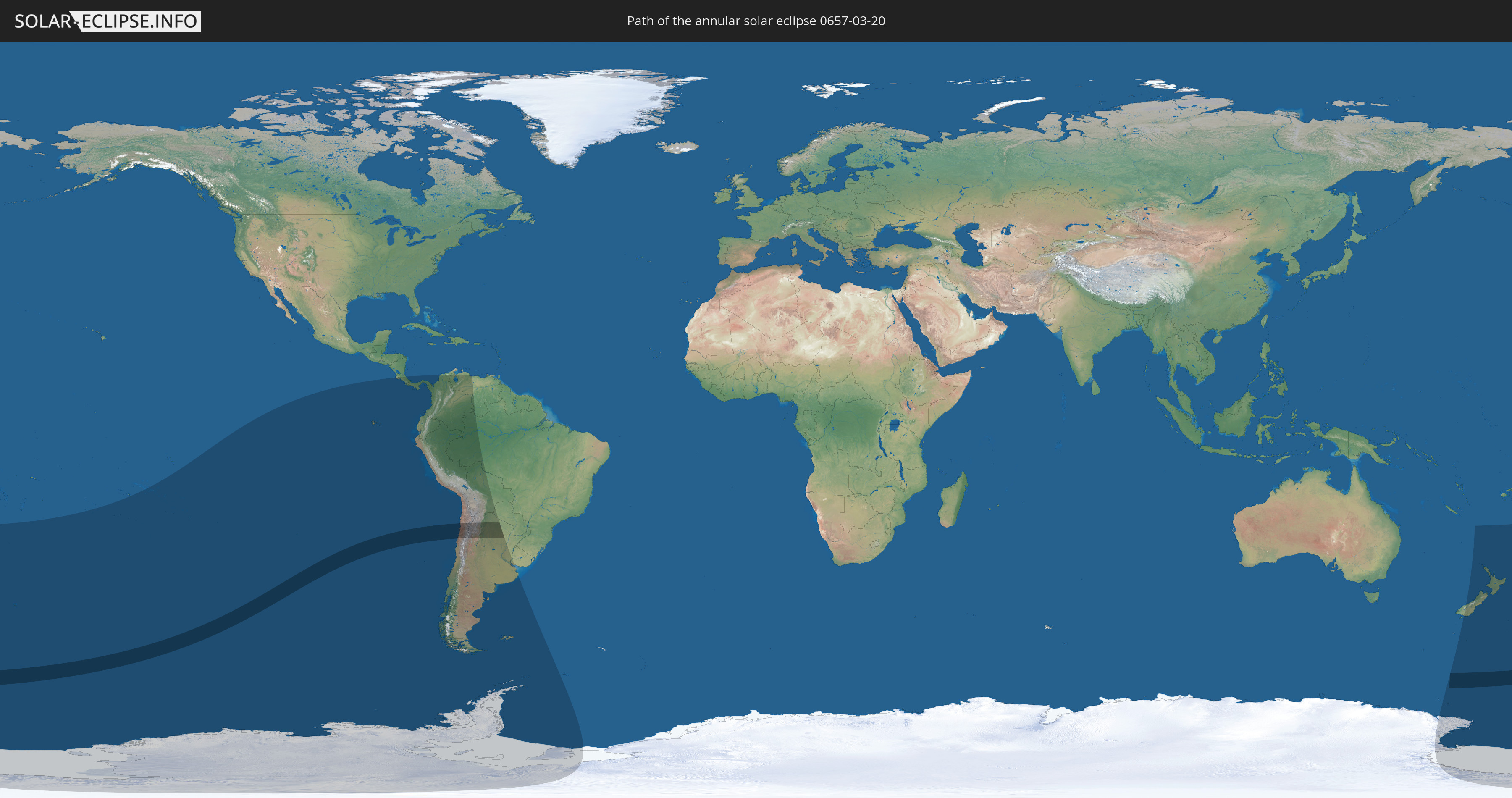
Die Sonnenfinsternis am 03/20/0657 kann man in 19 Ländern als partielle Sonnenfinsternis beobachten.
Der Finsternispfad verläuft durch 2 Länder. Nur in diesen Ländern ist sie als annular Sonnenfinsternis zu sehen.
In den folgenden Ländern ist die Sonnenfinsternis annular zu sehen
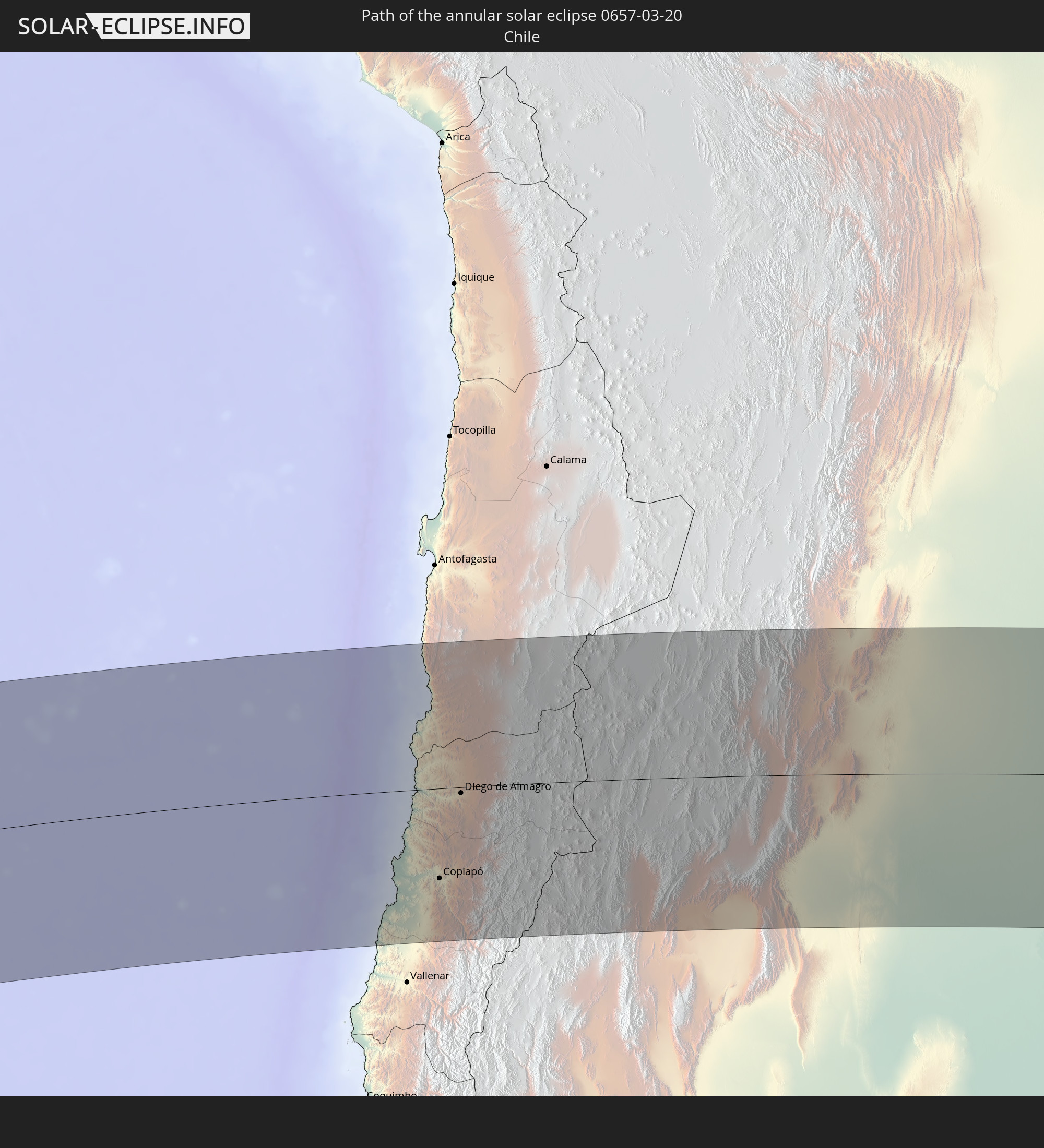 Chile
Chile
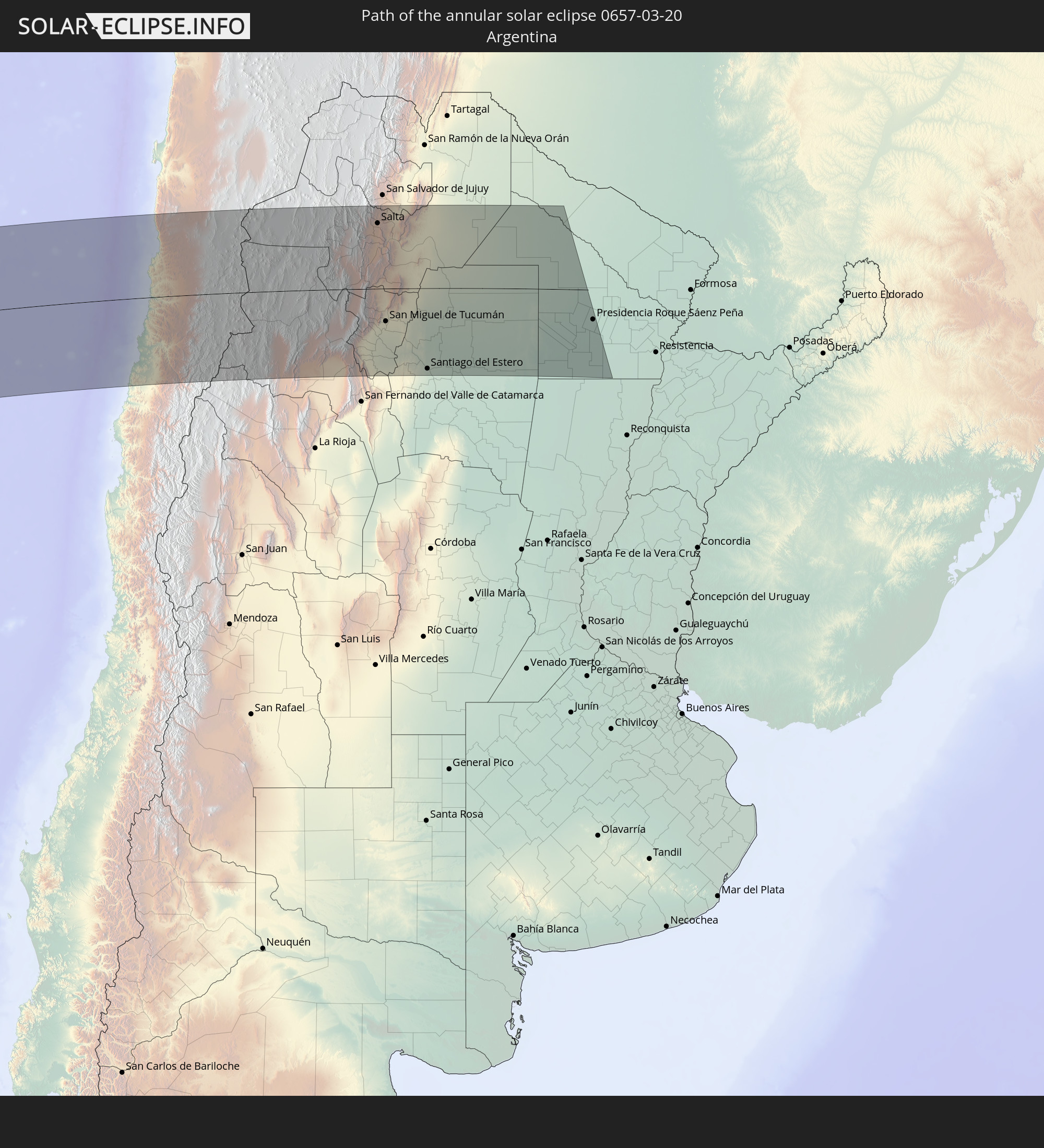 Argentina
In den folgenden Ländern ist die Sonnenfinsternis partiell zu sehen


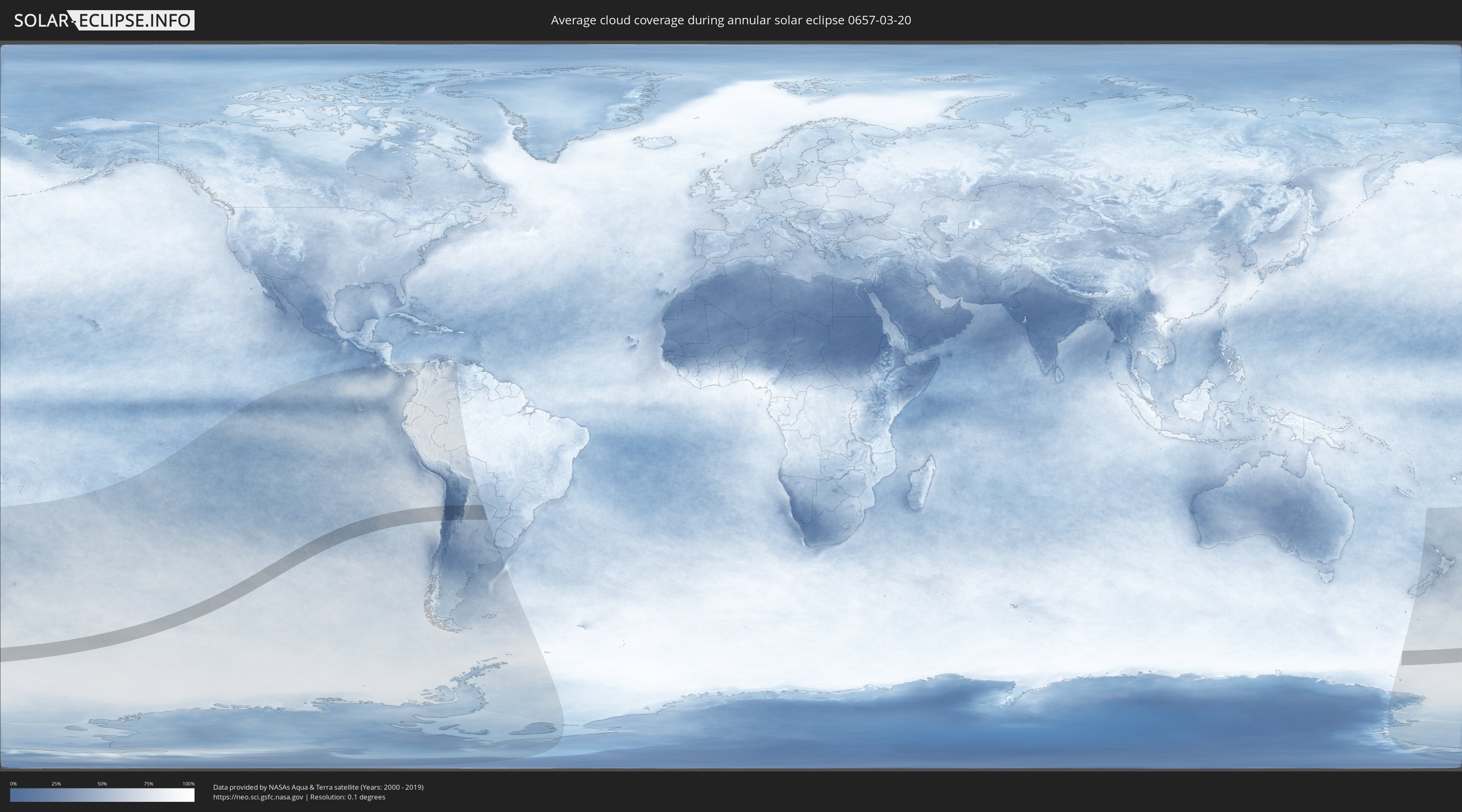
How will be the weather during the annular solar eclipse on 03/20/0657?
Where is the best place to see the annular solar eclipse of 03/20/0657?
The following maps show the average cloud coverage for the day of the annular solar eclipse.
With the help of these maps, it is possible to find the place along the eclipse path, which has the best
chance of a cloudless sky.
Nevertheless, you should consider local circumstances and inform about the weather of your chosen
observation site.
The data is provided by NASAs satellites
AQUA and TERRA.
The cloud maps are averaged over a period of 19 years (2000 - 2019).

Detailed country maps
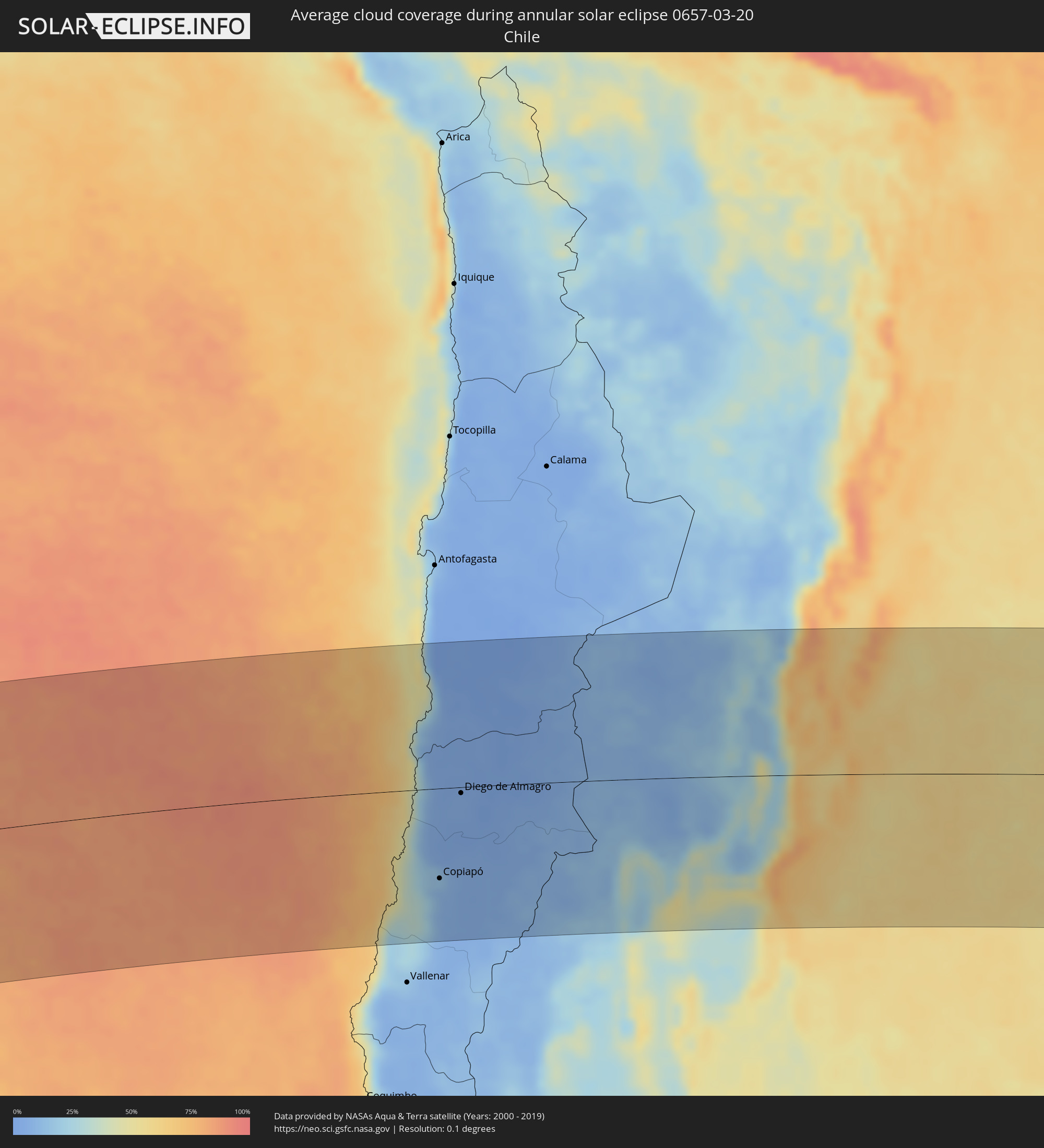 Chile
Chile
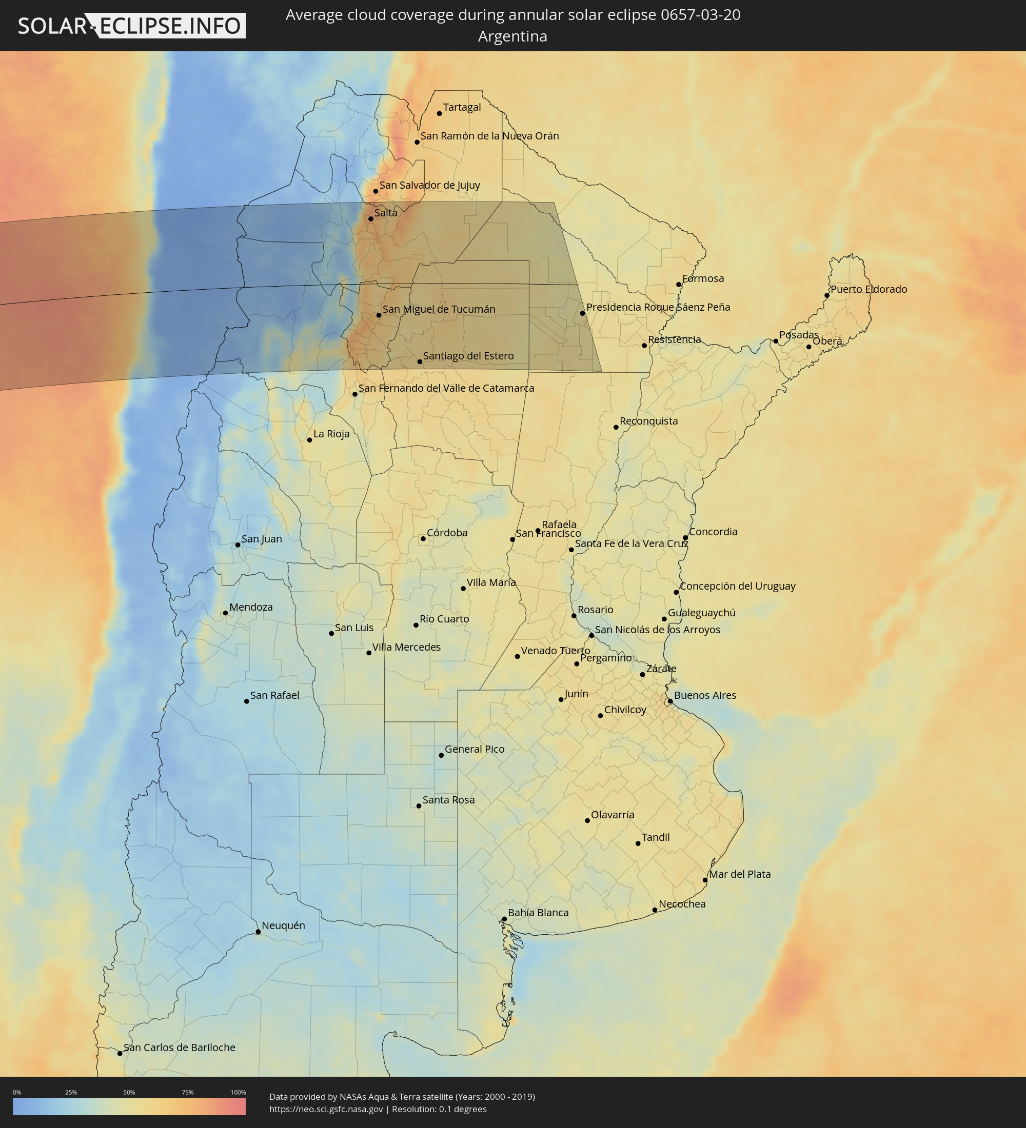 Argentina
Cities inside the path of the eclipse
The following table shows all locations with a population of more than 5,000 inside the eclipse path. Cities which have more than 100,000 inhabitants are marked bold. A click at the locations opens a detailed map.
| City | Type | Eclipse duration | Local time of max. eclipse | Distance to central line | Ø Cloud coverage |
 Taltal, Antofagasta
|
annular | - | 17:23:10 UTC-04:42 | 101 km | 25% |
|
Copiapó, Atacama
|
annular | - | 17:20:07 UTC-04:42 | 117 km | 9% |
|
Diego de Almagro, Atacama
|
annular | - | 17:21:50 UTC-04:42 | 8 km | 5% |
 Fiambalá, Catamarca Province
|
annular | - | 17:46:31 UTC-04:16 | 166 km | 23% |
|
Andalgalá, Catamarca Province
|
annular | - | 17:47:00 UTC-04:16 | 160 km | 36% |
|
Cafayate, Salta Province
|
annular | - | 17:49:25 UTC-04:16 | 10 km | 43% |
|
Aguilares, Tucumán Province
|
annular | - | 17:47:25 UTC-04:16 | 143 km | 67% |
|
La Cocha, Tucumán Province
|
annular | - | 17:46:54 UTC-04:16 | 181 km | 63% |
|
Chicoana, Salta Province
|
annular | - | 17:50:57 UTC-04:16 | 117 km | 68% |
|
Monteros, Tucumán Province
|
annular | - | 17:47:51 UTC-04:16 | 113 km | 67% |
|
El Carril, Salta Province
|
annular | - | 17:51:00 UTC-04:16 | 120 km | 68% |
|
Graneros, Tucumán Province
|
annular | - | 17:47:07 UTC-04:16 | 167 km | 62% |
|
Salta, Salta Province
|
annular | - | 17:51:26 UTC-04:16 | 152 km | 72% |
|
Famaillá, Tucumán Province
|
annular | - | 17:48:03 UTC-04:16 | 101 km | 66% |
|
Simoca, Tucumán Province
|
annular | - | 17:47:44 UTC-04:16 | 124 km | 64% |
|
Yerba Buena, Tucumán Province
|
annular | - | 17:48:26 UTC-04:16 | 74 km | 68% |
|
Bella Vista, Tucumán Province
|
annular | - | 17:48:06 UTC-04:16 | 99 km | 65% |
|
Trancas, Tucumán Province
|
annular | - | 17:49:21 UTC-04:16 | 7 km | 58% |
|
Tafí Viejo, Tucumán Province
|
annular | - | 17:48:34 UTC-04:16 | 65 km | 69% |
|
San Miguel de Tucumán, Tucumán Province
|
annular | - | 17:48:26 UTC-04:16 | 75 km | 65% |
|
Alderetes, Tucumán Province
|
annular | - | 17:48:28 UTC-04:16 | 75 km | 64% |
|
Termas de Río Hondo, Santiago del Estero Province
|
annular | - | 17:47:29 UTC-04:16 | 150 km | 54% |
|
El Galpón, Salta Province
|
annular | - | 17:50:41 UTC-04:16 | 85 km | 61% |
|
Santiago del Estero, Santiago del Estero Province
|
annular | - | 17:47:08 UTC-04:16 | 184 km | 56% |
|
Las Lajitas, Salta Province
|
annular | - | 17:51:46 UTC-04:16 | 162 km | 60% |
|
Joaquín V. González, Salta Province
|
annular | - | 17:51:11 UTC-04:16 | 118 km | 59% |
|
Clodomira, Santiago del Estero Province
|
annular | - | 17:47:29 UTC-04:16 | 160 km | 61% |
|
El Quebrachal, Salta Province
|
annular | - | 17:50:55 UTC-04:16 | 95 km | 57% |
|
Beltrán, Santiago del Estero Province
|
annular | - | 17:47:07 UTC-04:16 | 188 km | 58% |
|
Apolinario Saravia, Salta Province
|
annular | - | 17:52:09 UTC-04:16 | 190 km | 58% |
|
Taco Pozo, Chaco Province
|
annular | - | 17:50:32 UTC-04:16 | 58 km | 59% |
|
Campo Gallo, Santiago del Estero Province
|
annular | - | 17:49:10 UTC-04:16 | 49 km | 56% |
|
Quimilí, Santiago del Estero Province
|
annular | - | 17:47:39 UTC-04:16 | 166 km | 56% |
|
Los Frentones, Chaco Province
|
annular | - | 17:49:32 UTC-04:16 | 28 km | 52% |
|
Hermoso Campo, Chaco Province
|
annular | - | 17:47:47 UTC-04:16 | 161 km | 56% |
|
General Pinedo, Chaco Province
|
annular | - | 17:48:13 UTC-04:16 | 129 km | 56% |
|
Charata, Chaco Province
|
annular | - | 17:48:23 UTC-04:16 | 117 km | 55% |
|
Pampa del Infierno, Chaco Province
|
annular | - | 17:49:25 UTC-04:16 | 38 km | 50% |
|
Santa Sylvina, Chaco Province
|
annular | - | 17:47:28 UTC-04:16 | 186 km | 52% |
|
Las Breñas, Chaco Province
|
annular | - | 17:48:34 UTC-04:16 | 103 km | 54% |
|
Corzuela, Chaco Province
|
annular | - | 17:48:46 UTC-04:16 | 88 km | 52% |
|
Concepción del Bermejo, Chaco Province
|
annular | - | 17:49:17 UTC-04:16 | 48 km | 49% |
|
Coronel Du Graty, Chaco Province
|
annular | - | 17:47:42 UTC-04:16 | 169 km | 54% |
|
Campo Largo, Chaco Province
|
annular | - | 17:49:00 UTC-04:16 | 71 km | 50% |
|
Aviá Terai, Chaco Province
|
annular | - | 17:49:10 UTC-04:16 | 58 km | 49% |
|
Villa Ángela, Chaco Province
|
annular | - | 17:47:52 UTC-04:16 | 156 km | 54% |
|
San Bernardo, Chaco Province
|
annular | - | 17:48:18 UTC-04:16 | 125 km | 54% |
|
Presidencia Roque Sáenz Peña, Chaco Province
|
annular | - | 17:49:02 UTC-04:16 | 69 km | 54% |
|
Villa Berthet, Chaco Province
|
annular | - | 17:48:18 UTC-04:16 | 126 km | 53% |