Total solar eclipse of 10/05/0693
| Day of week: | Thursday |
| Maximum duration of eclipse: | 04m30s |
| Maximum width of eclipse path: | 196 km |
| Saros cycle: | 103 |
| Coverage: | 100% |
| Magnitude: | 1.0517 |
| Gamma: | 0.491 |
Wo kann man die Sonnenfinsternis vom 10/05/0693 sehen?

Die Sonnenfinsternis am 10/05/0693 kann man in 120 Ländern als partielle Sonnenfinsternis beobachten.
Der Finsternispfad verläuft durch 22 Länder. Nur in diesen Ländern ist sie als total Sonnenfinsternis zu sehen.
In den folgenden Ländern ist die Sonnenfinsternis total zu sehen
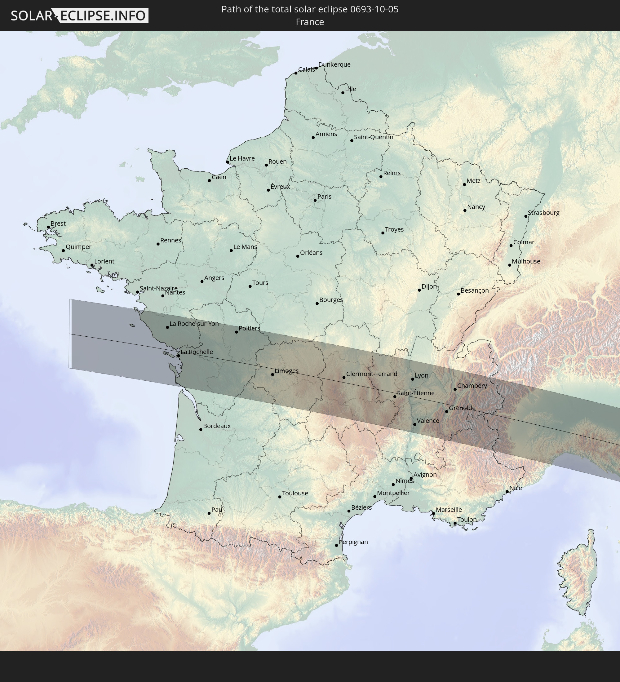 France
 Italy
Italy
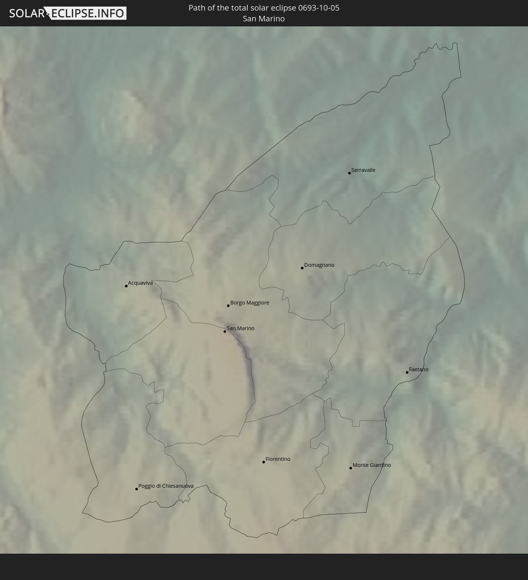 San Marino
 Croatia
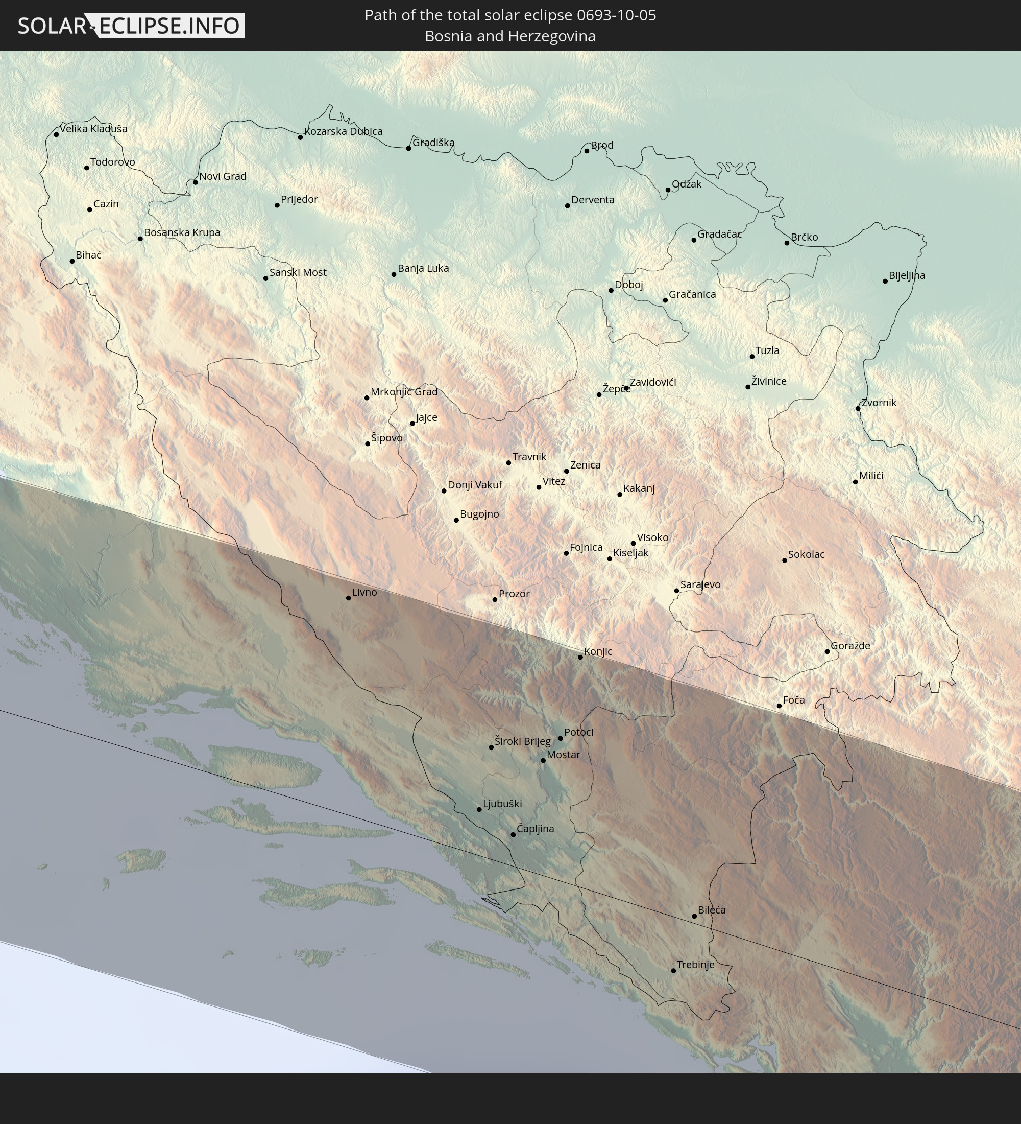 Bosnia and Herzegovina
 Montenegro
 Serbia
 Albania
 Greece
 Republic of Macedonia
 Bulgaria
 Turkey
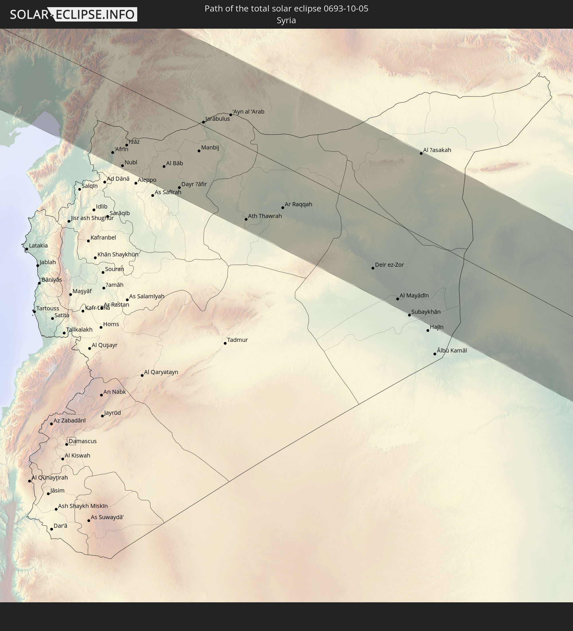 Syria
Syria
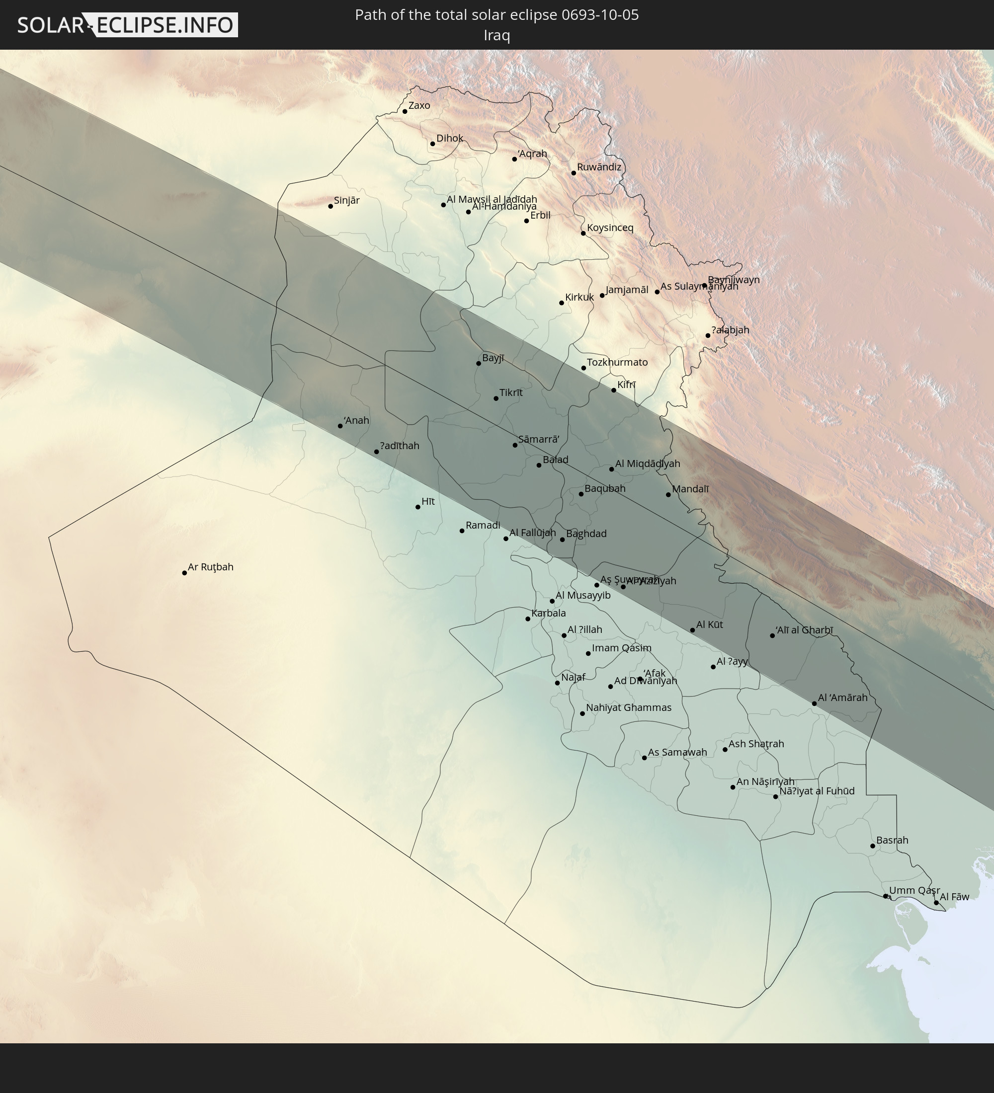 Iraq
Iraq
 Iran
Iran
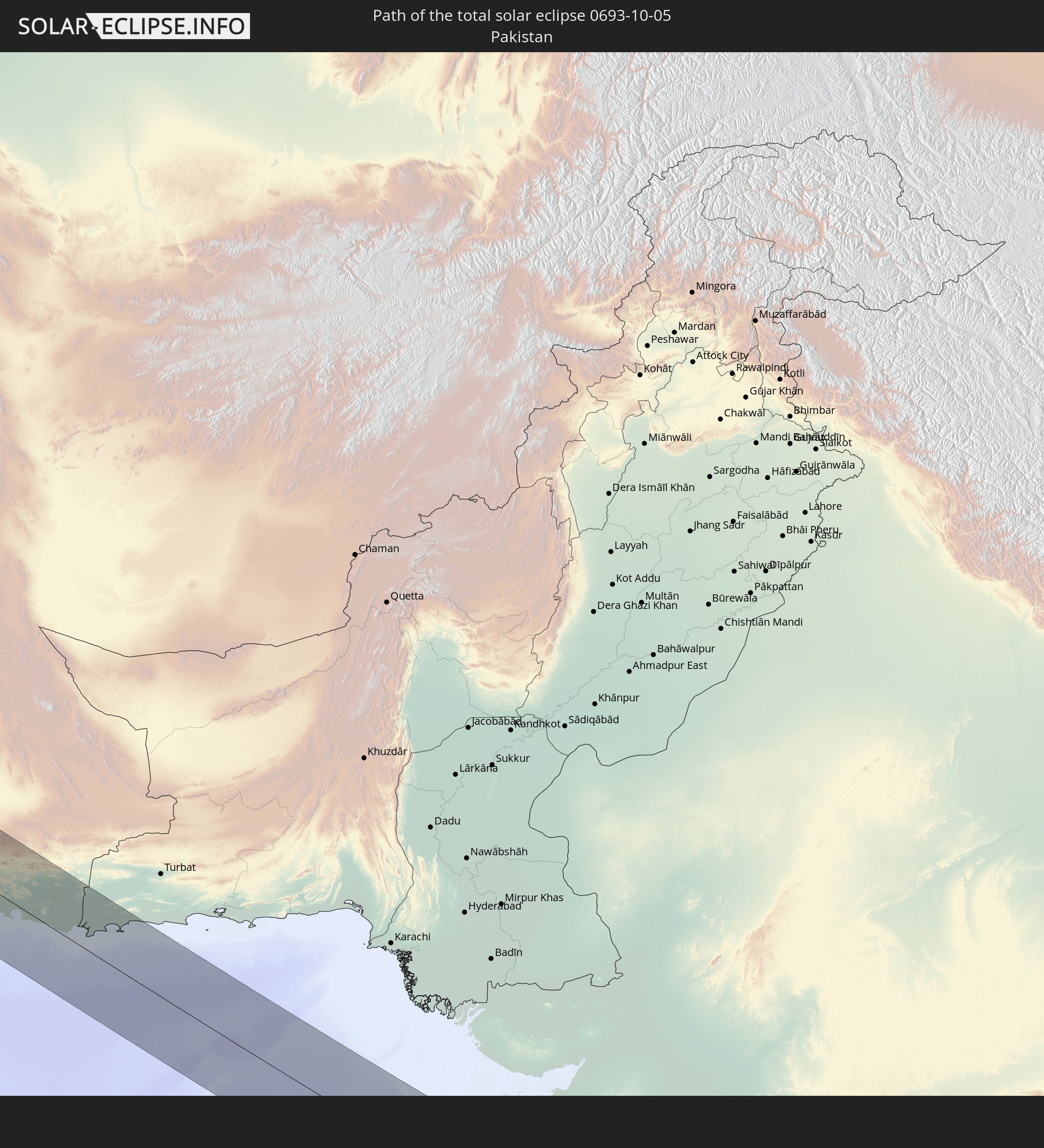 Pakistan
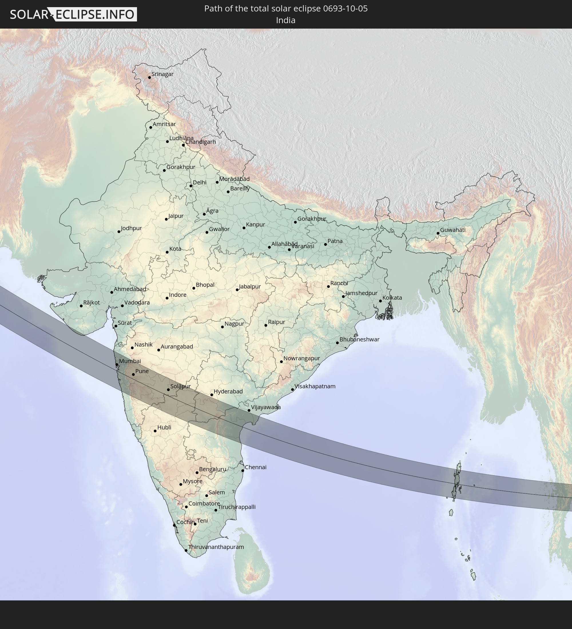 India
India
 Myanmar
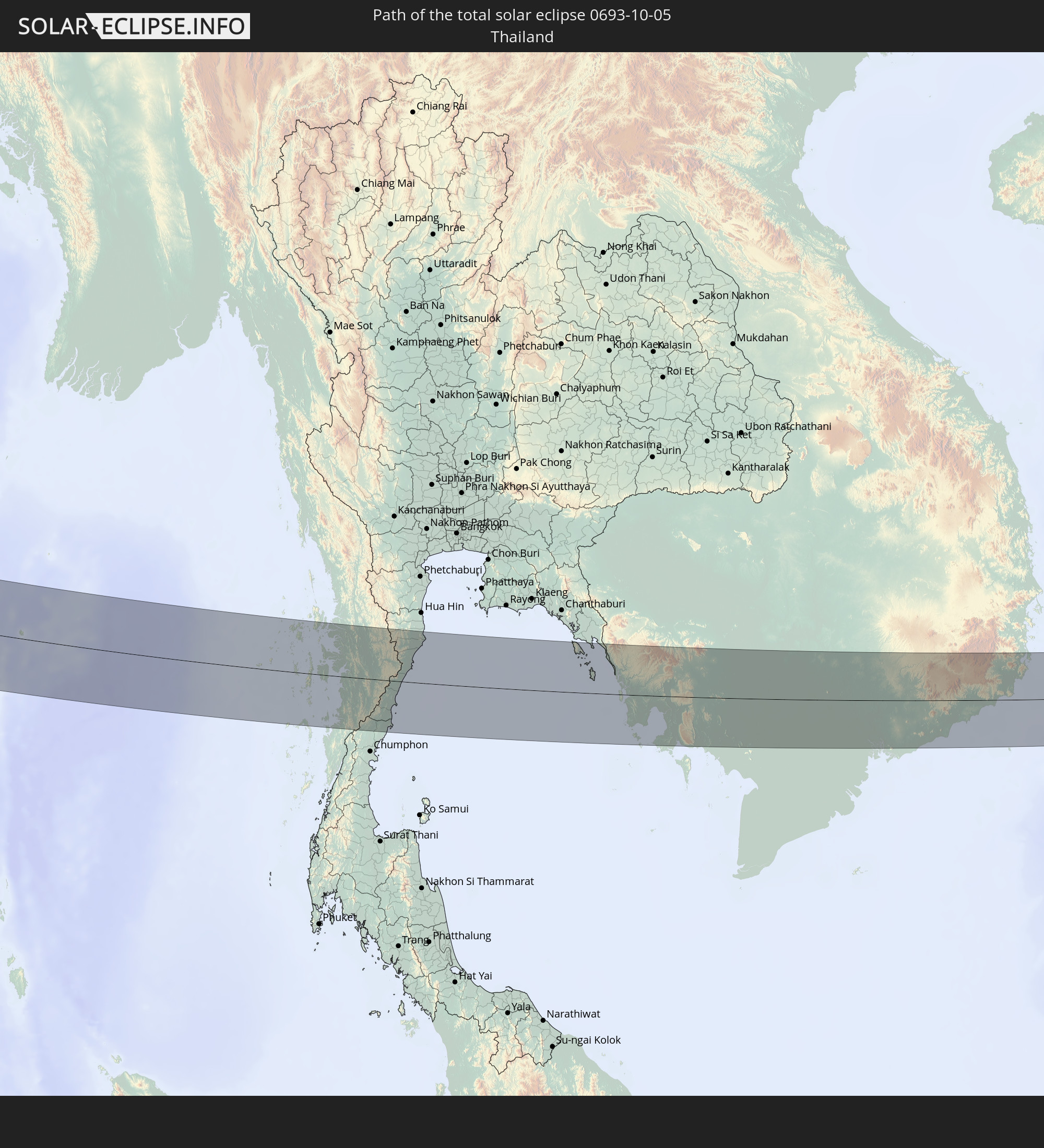 Thailand
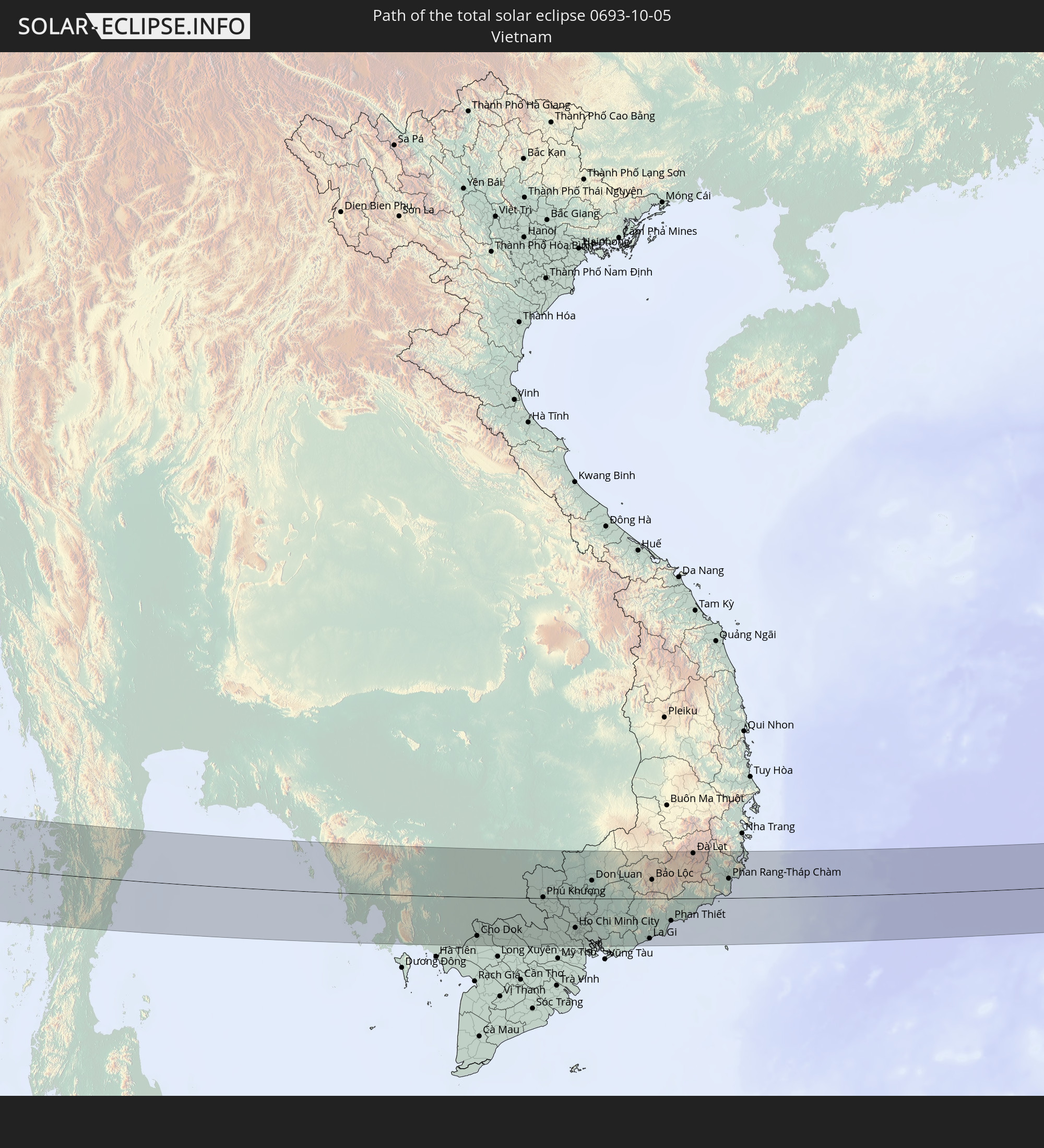 Vietnam
 Cambodia
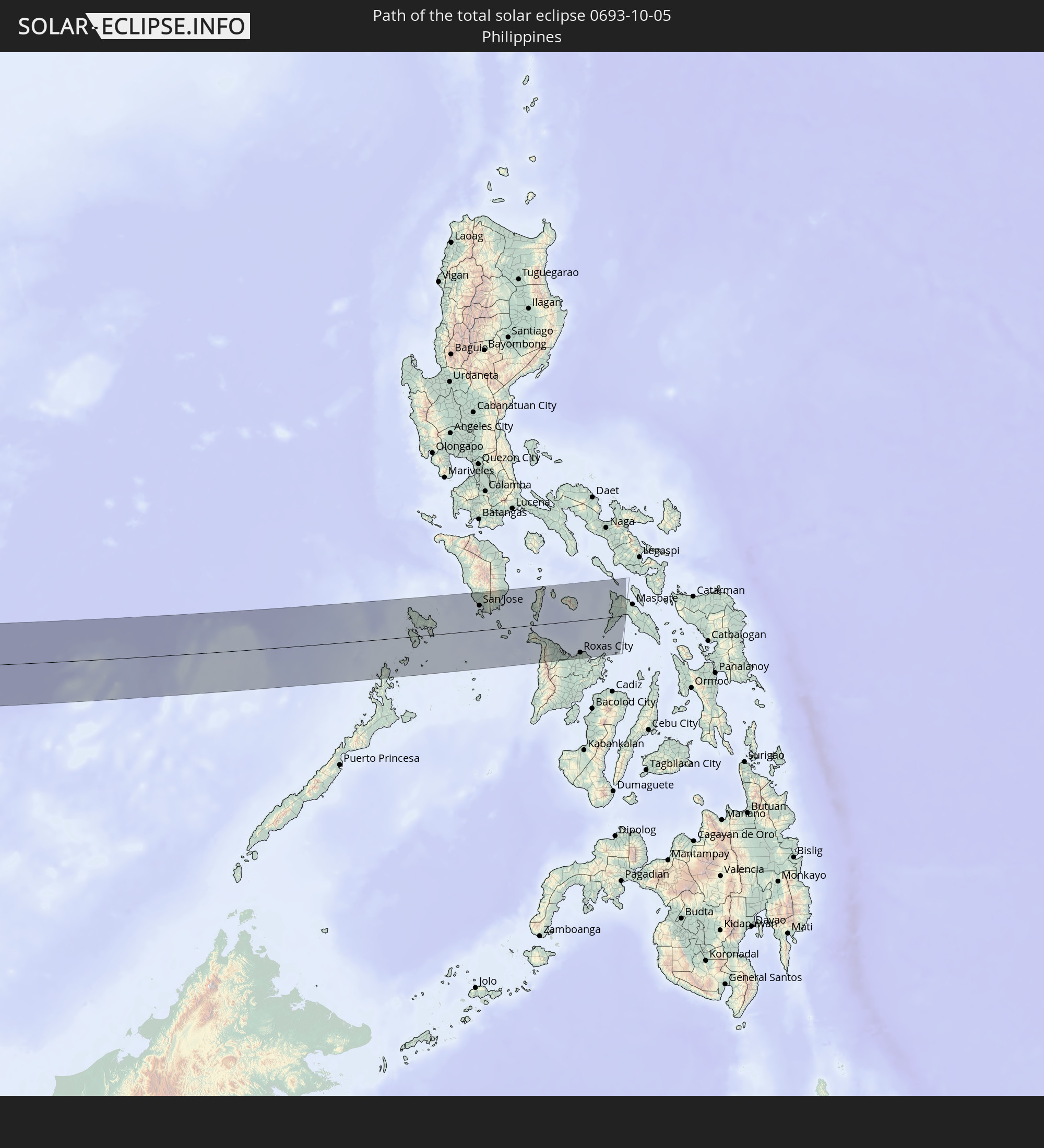 Philippines
In den folgenden Ländern ist die Sonnenfinsternis partiell zu sehen
 Russia
 Spain
Spain
 Mauritania
 Morocco
 Mali
Mali
 Svalbard and Jan Mayen
 Algeria
 United Kingdom
 Burkina Faso
 France
 Guernsey
 Jersey
 Niger
Niger
 Andorra
 Belgium
 Nigeria
 Netherlands
 Norway
 Luxembourg
 Germany
 Switzerland
 Italy
Italy
 Monaco
 Tunisia
 Denmark
 Cameroon
 Libya
Libya
 Liechtenstein
 Austria
 Sweden
 Czechia
 San Marino
 Vatican City
 Slovenia
 Chad
Chad
 Croatia
 Poland
 Malta
Malta
 Central African Republic
 Bosnia and Herzegovina
 Hungary
 Slovakia
 Montenegro
 Serbia
 Albania
 Åland Islands
 Greece
 Romania
 Republic of Macedonia
 Finland
 Lithuania
 Latvia
 Estonia
 Sudan
Sudan
 Ukraine
 Bulgaria
 Belarus
 Egypt
Egypt
 Turkey
 Moldova
 Uganda
 Cyprus
 Ethiopia
 Kenya
Kenya
 State of Palestine
 Israel
 Saudi Arabia
 Jordan
 Lebanon
 Syria
Syria
 Eritrea
 Iraq
Iraq
 Georgia
 Somalia
 Djibouti
 Yemen
Yemen
 Armenia
 Iran
Iran
 Azerbaijan
 Seychelles
 Kazakhstan
 Kuwait
 Bahrain
 Qatar
Qatar
 United Arab Emirates
 Oman
Oman
 Turkmenistan
 Uzbekistan
 Afghanistan
 Pakistan
 Tajikistan
 India
India
 Kyrgyzstan
 British Indian Ocean Territory
 Maldives
 China
China
 Sri Lanka
 Nepal
Nepal
 Mongolia
 Bangladesh
 Bhutan
 Myanmar
 Indonesia
 Cocos Islands
 Thailand
 Malaysia
 Laos
Laos
 Vietnam
 Cambodia
 Singapore
 Christmas Island
 Australia
 Macau
Macau
 Hong Kong
 Brunei
 Taiwan
 Philippines
 Japan
Japan
 North Korea
 South Korea
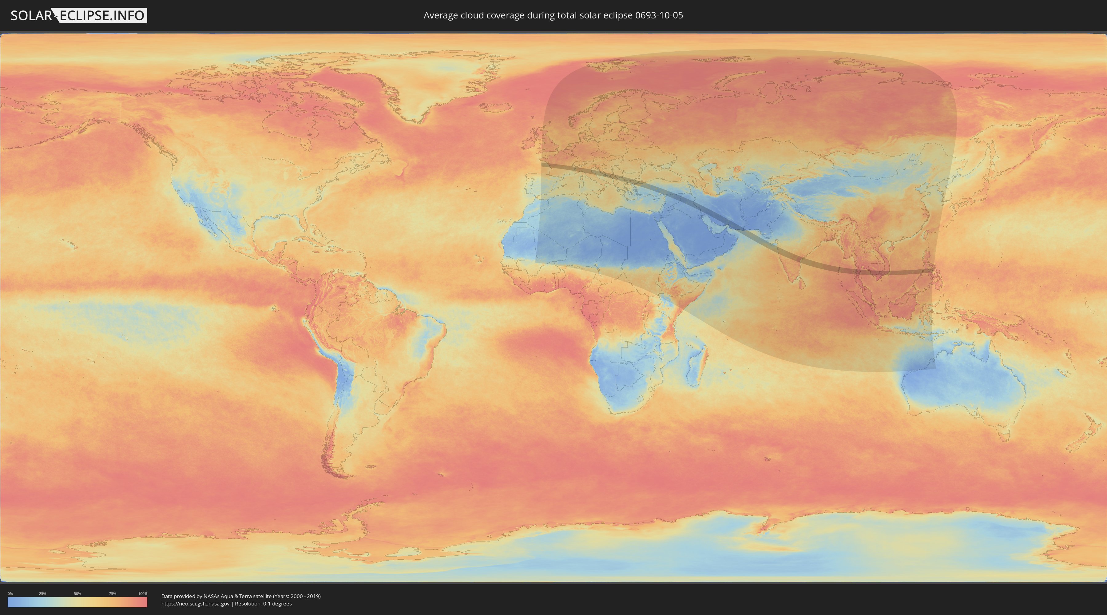
How will be the weather during the total solar eclipse on 10/05/0693?
Where is the best place to see the total solar eclipse of 10/05/0693?
The following maps show the average cloud coverage for the day of the total solar eclipse.
With the help of these maps, it is possible to find the place along the eclipse path, which has the best
chance of a cloudless sky.
Nevertheless, you should consider local circumstances and inform about the weather of your chosen
observation site.
The data is provided by NASAs satellites
AQUA and TERRA.
The cloud maps are averaged over a period of 19 years (2000 - 2019).

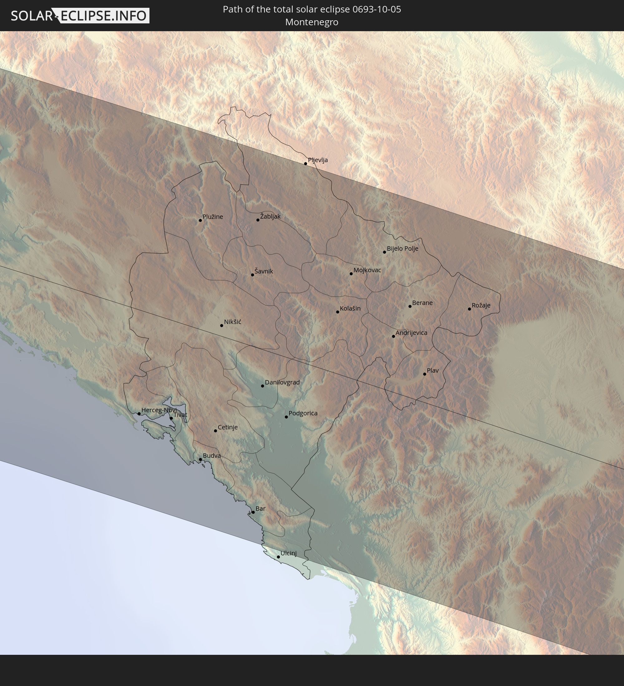
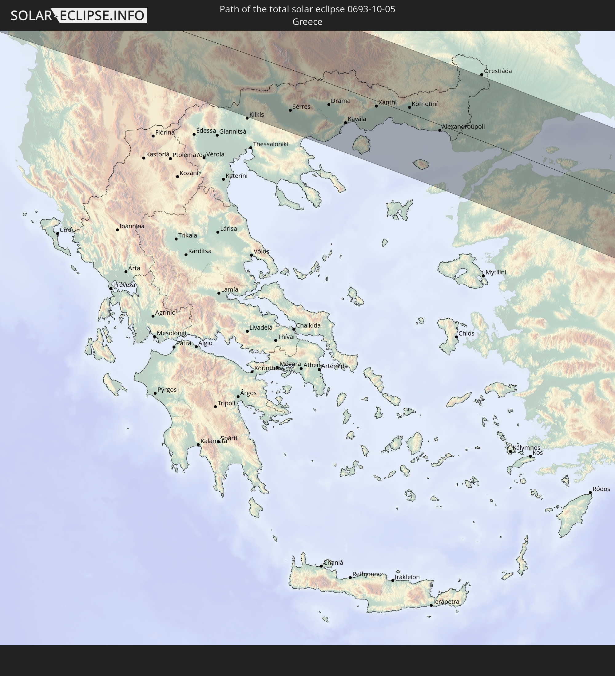
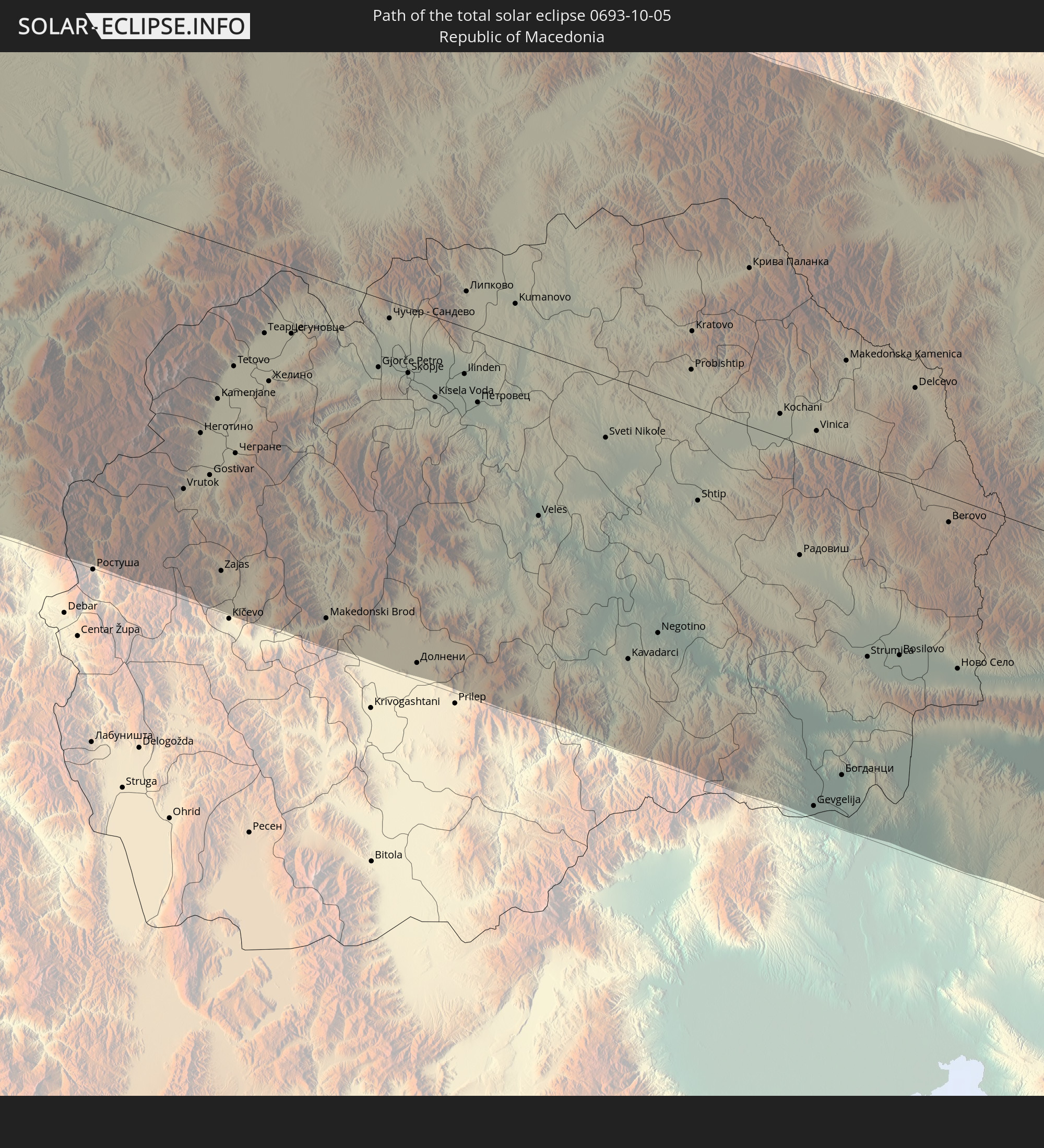
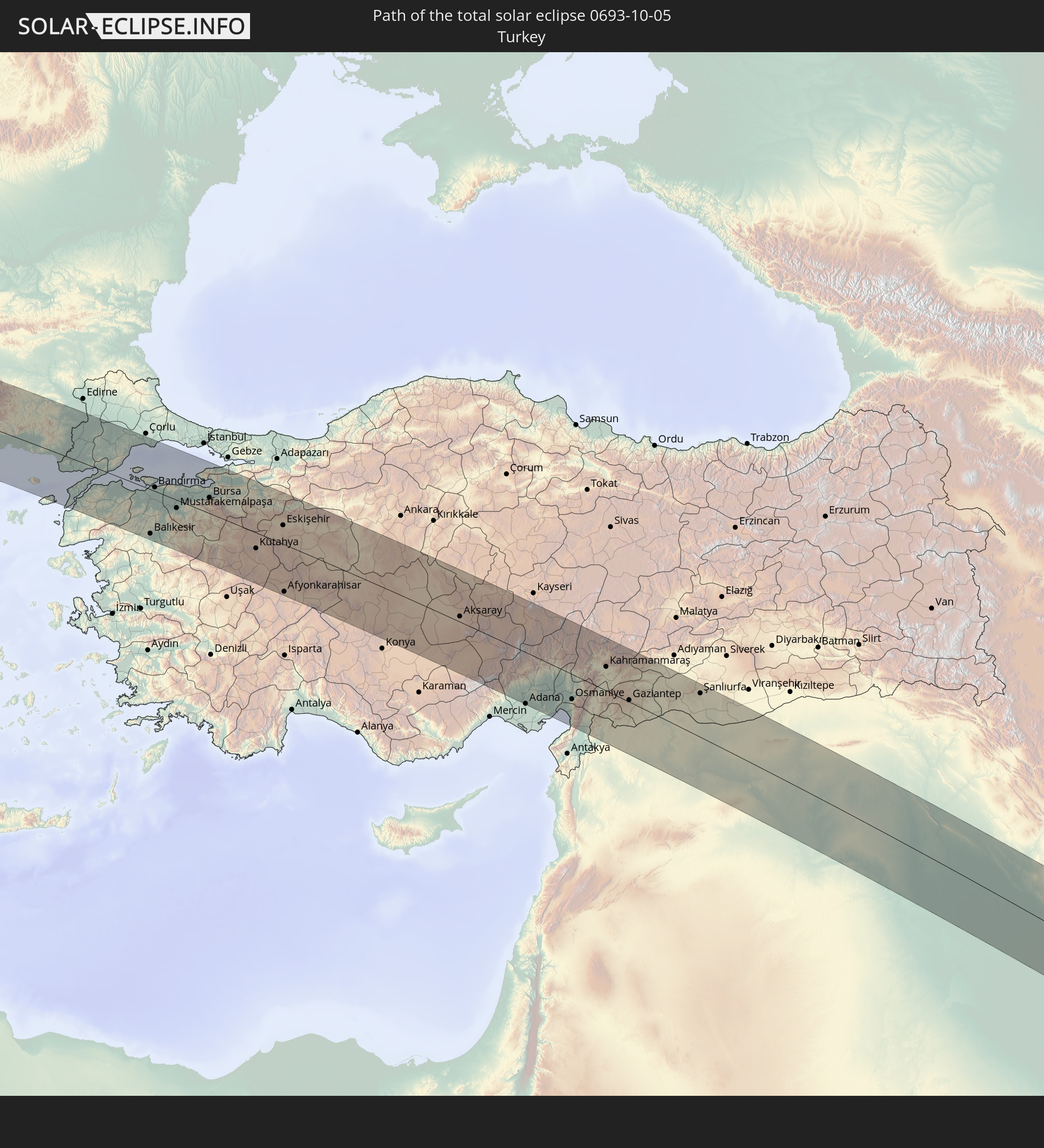
Detailed country maps
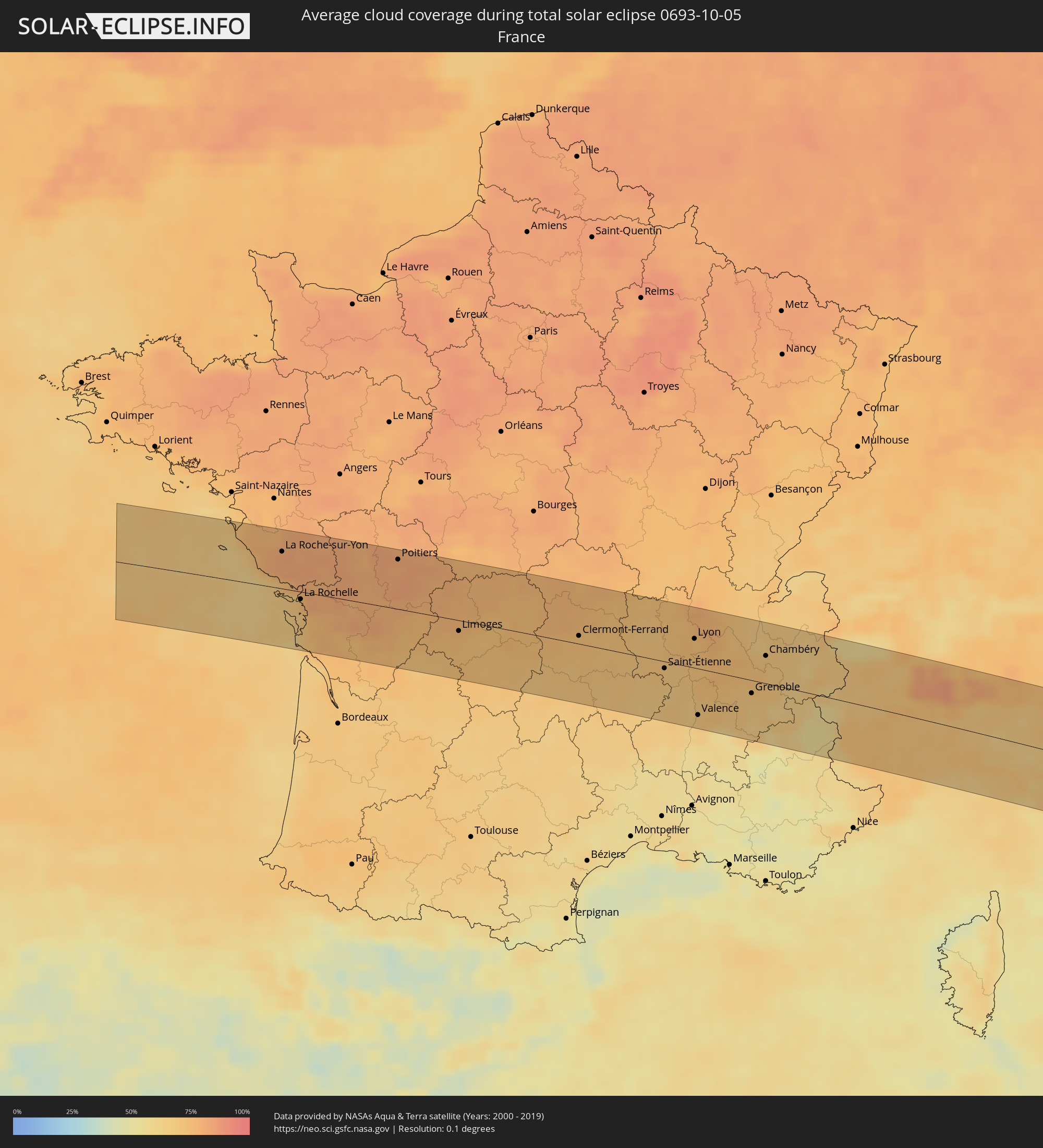 France
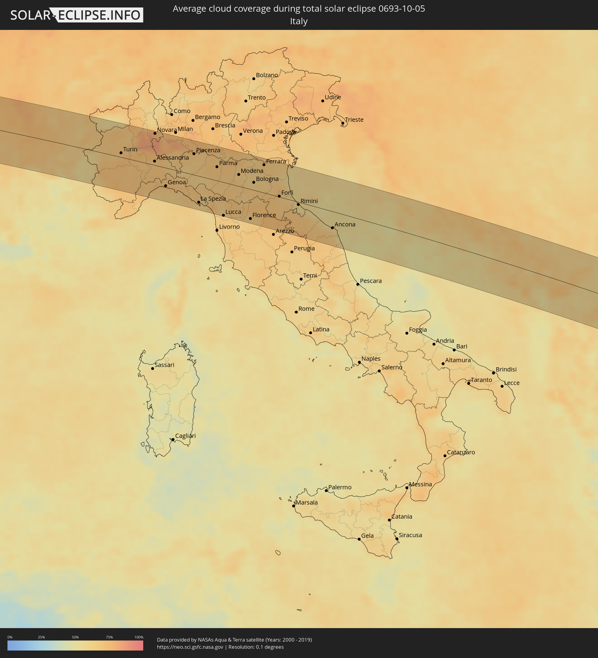 Italy
Italy
 San Marino
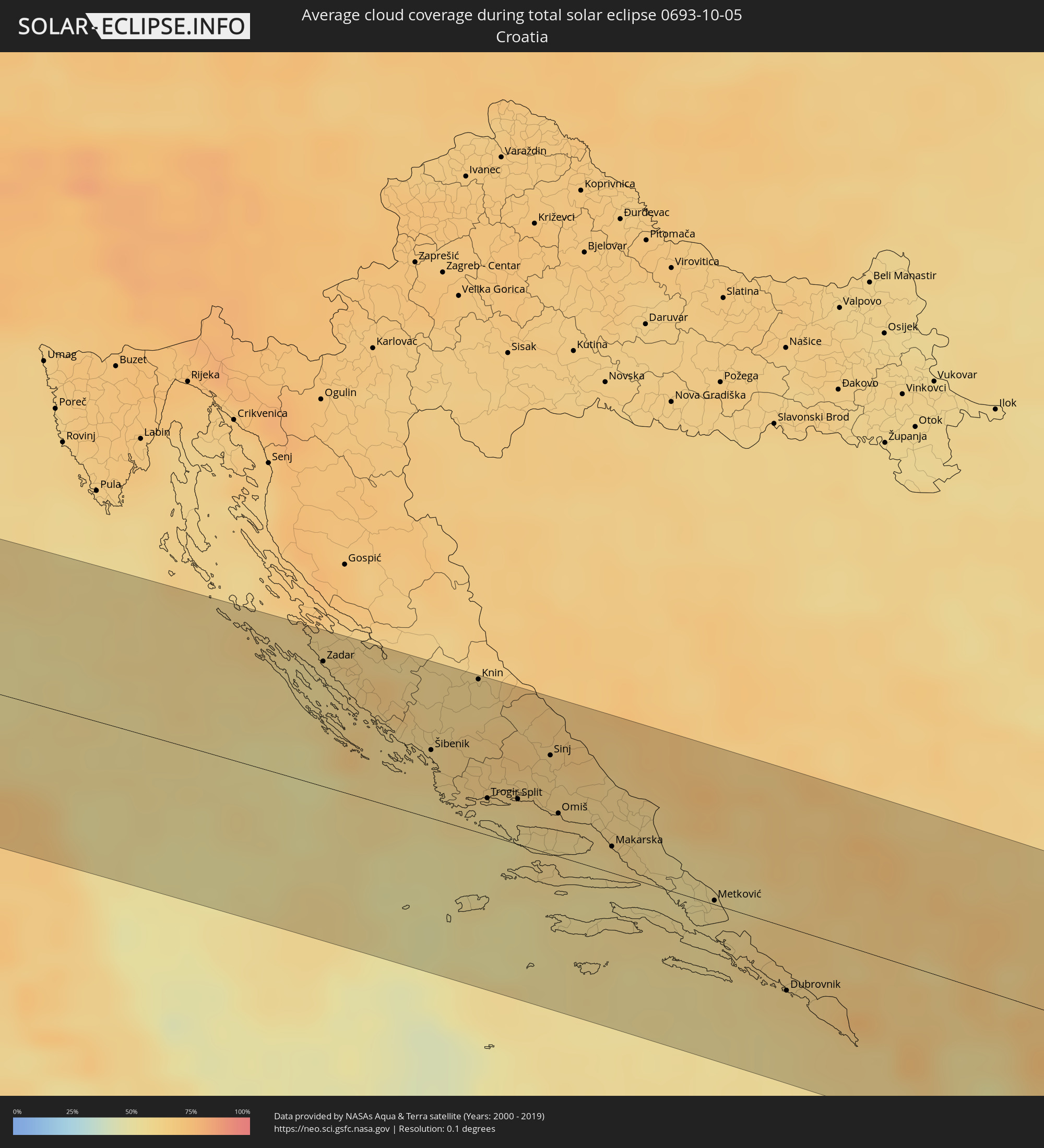 Croatia
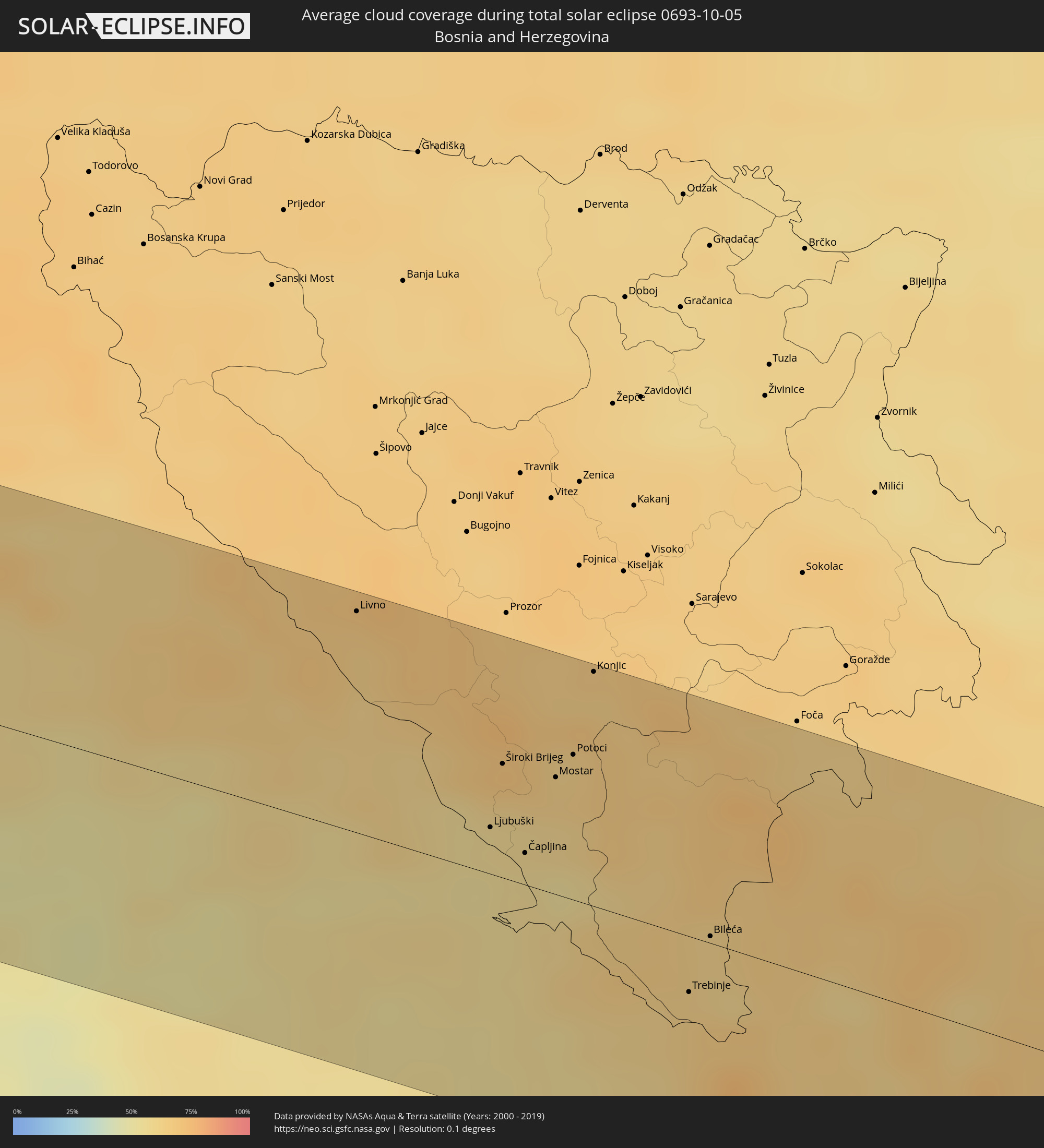 Bosnia and Herzegovina
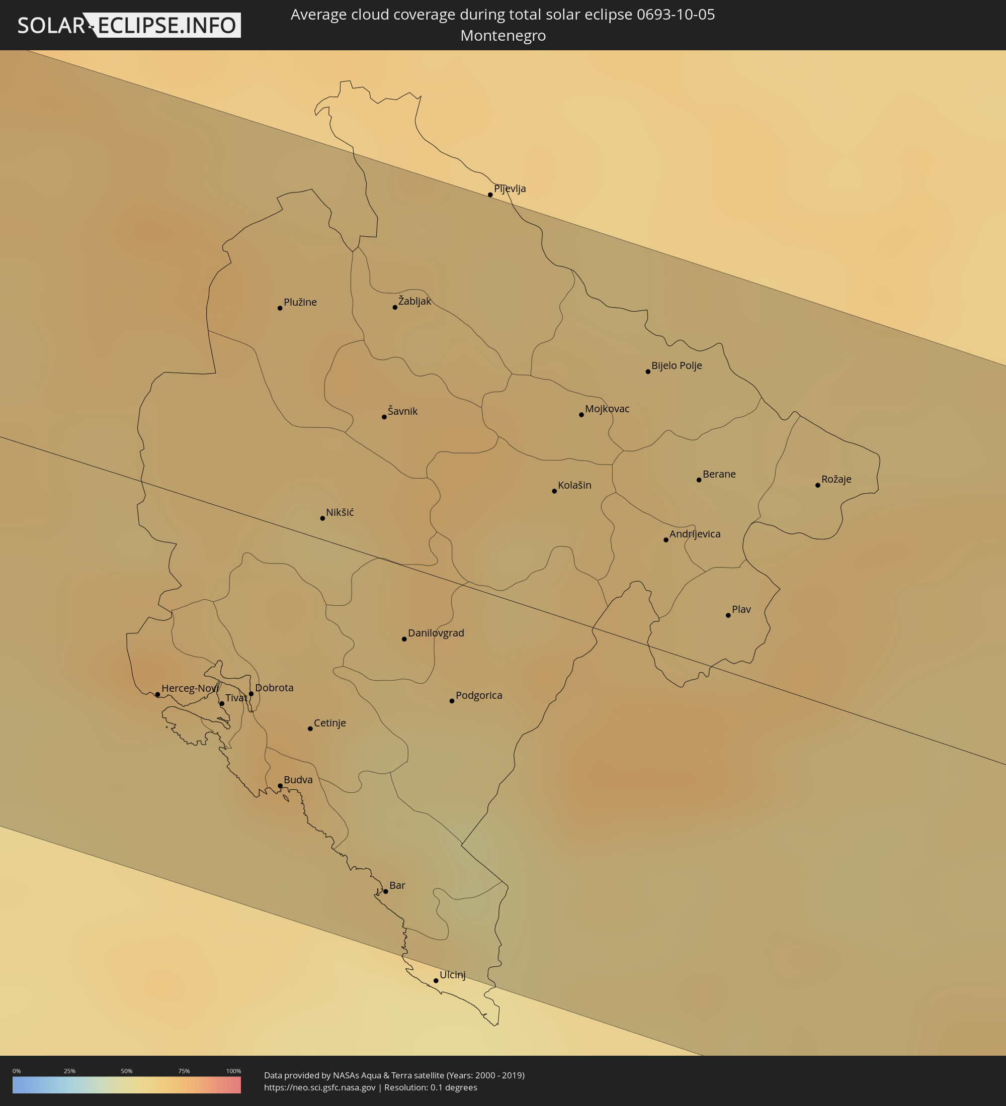 Montenegro
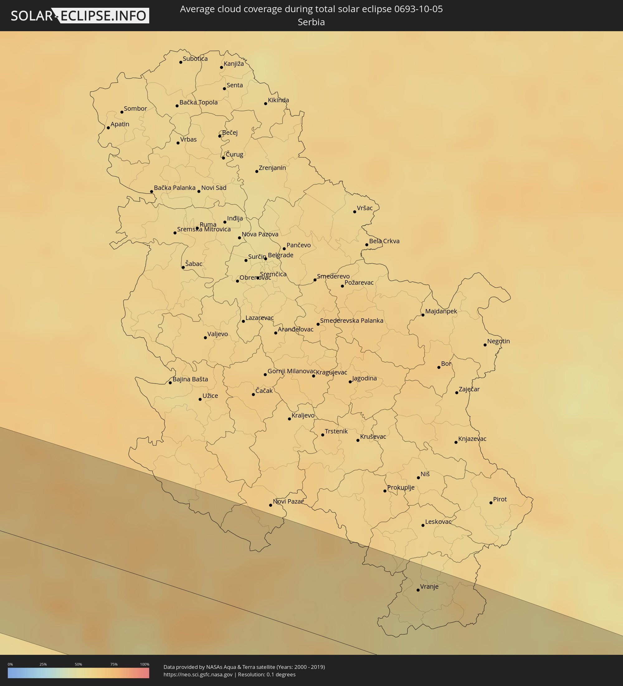 Serbia
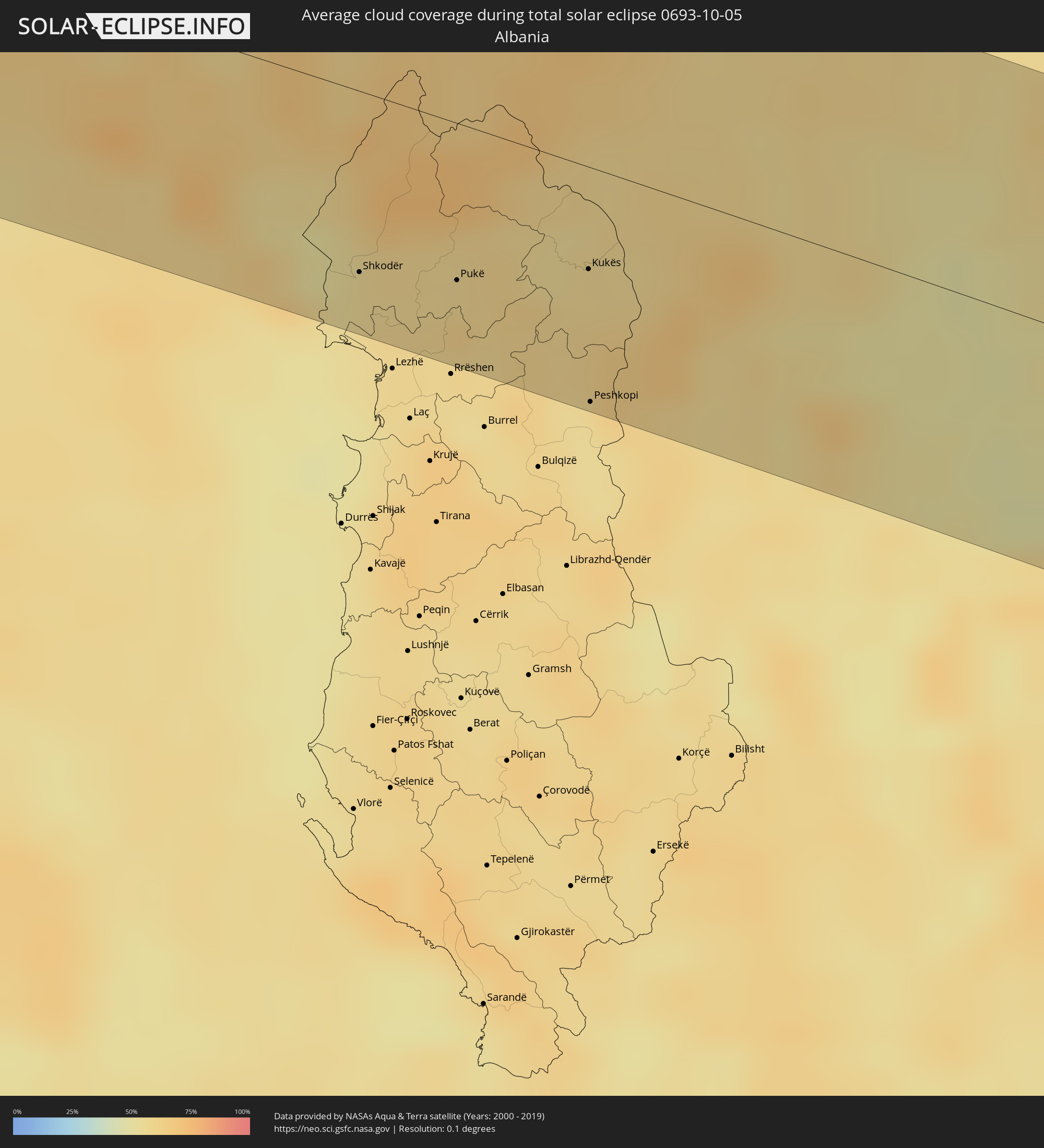 Albania
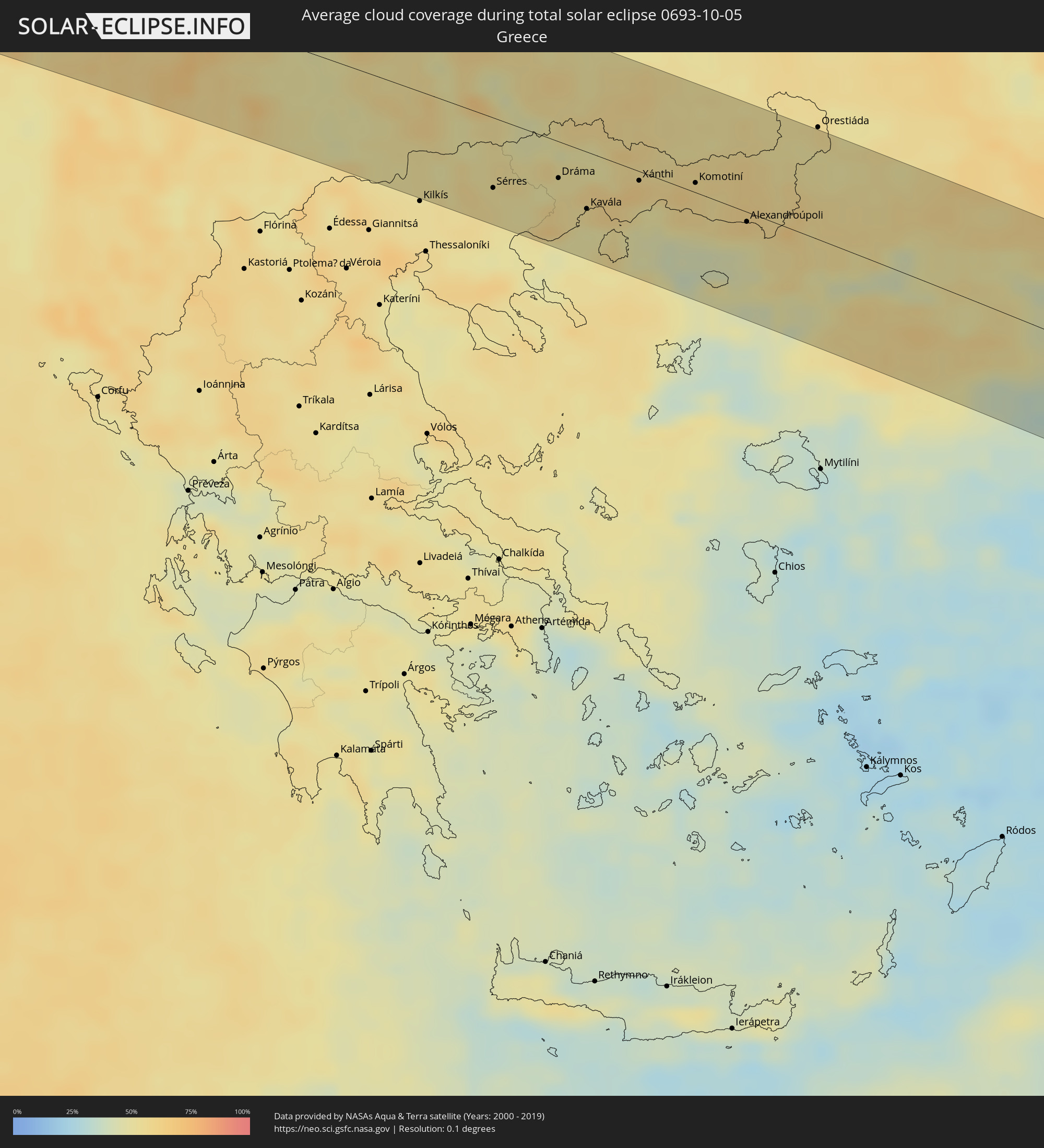 Greece
 Republic of Macedonia
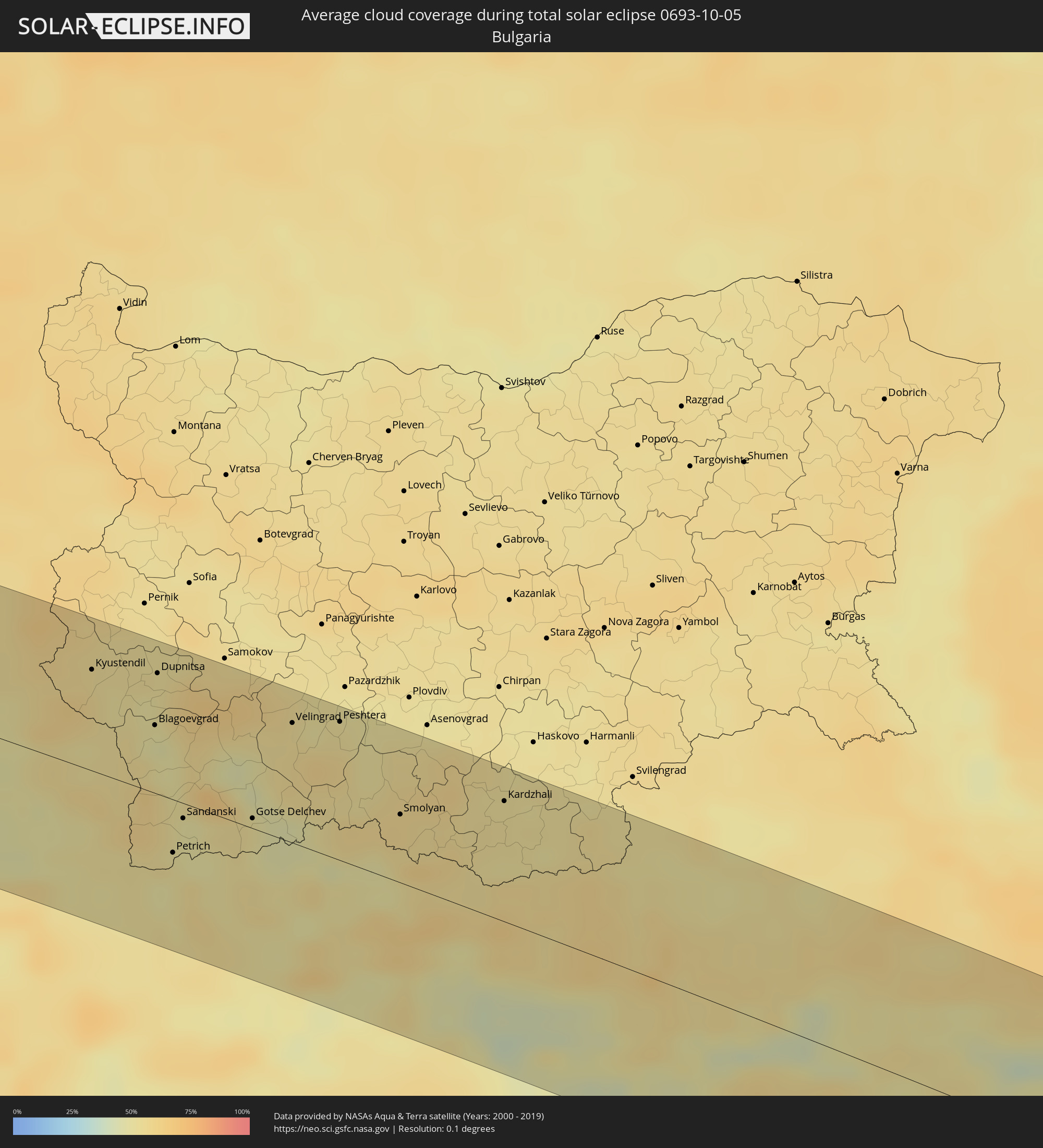 Bulgaria
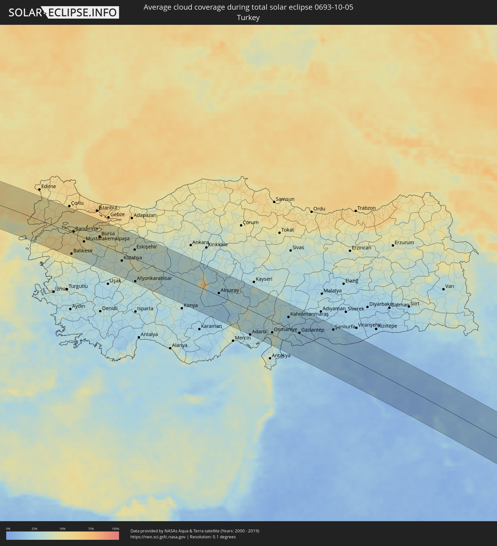 Turkey
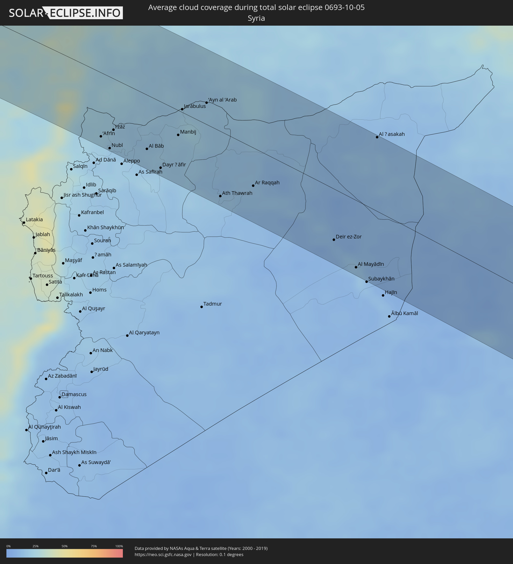 Syria
Syria
 Iraq
Iraq
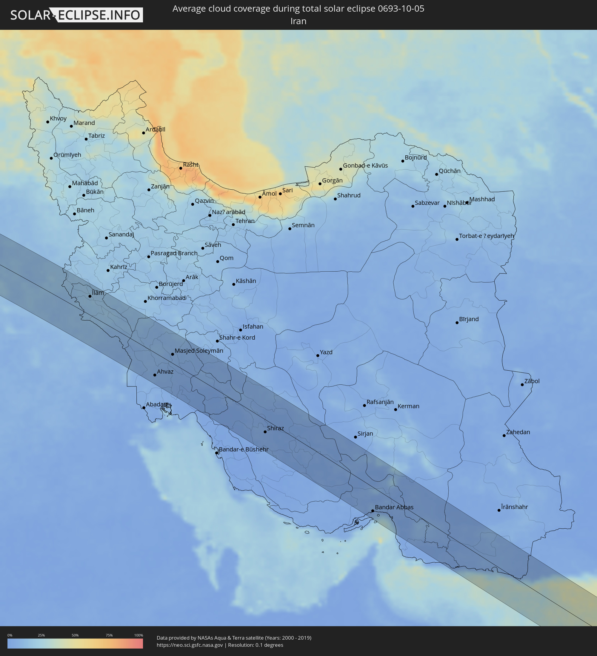 Iran
Iran
 Pakistan
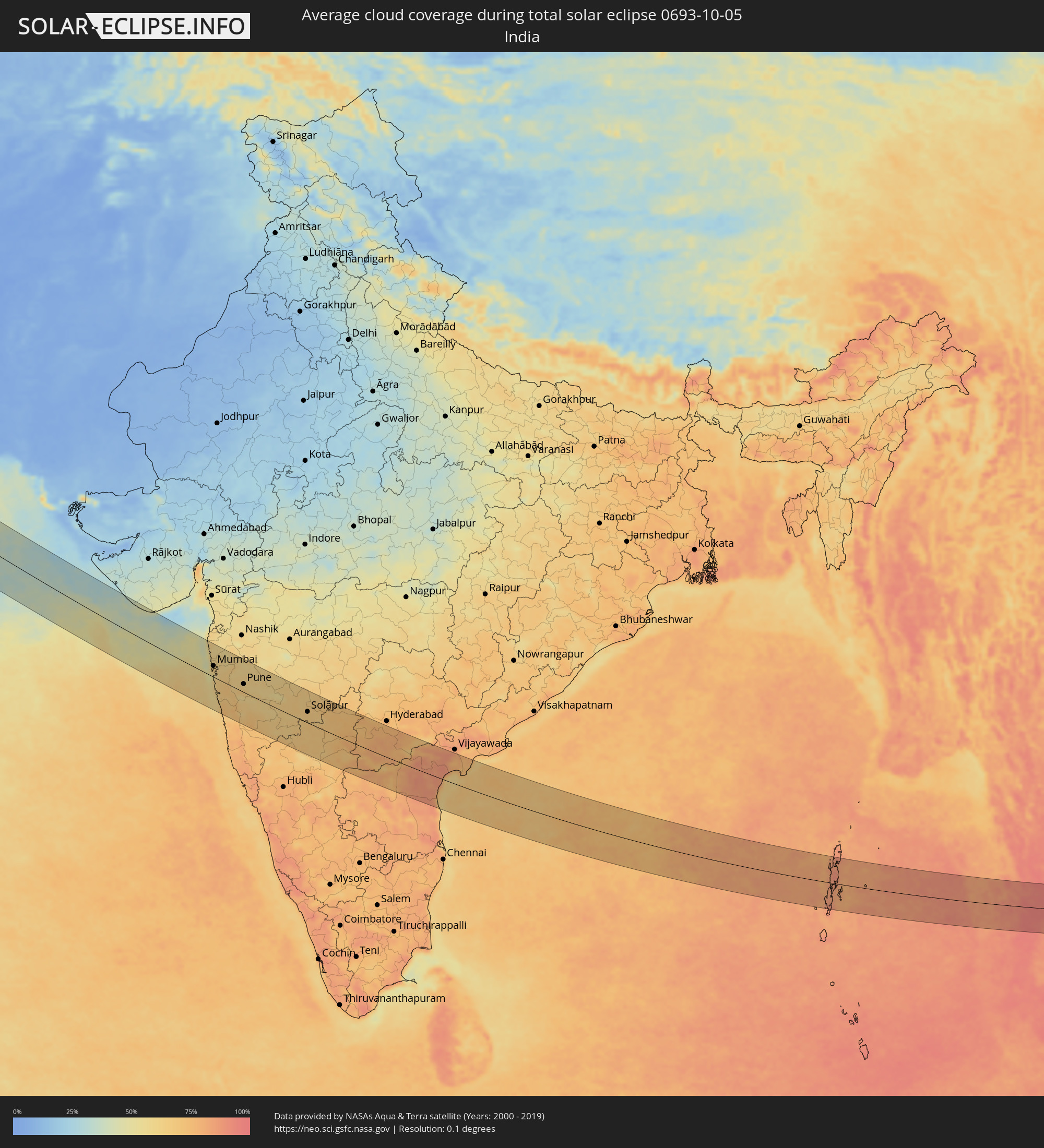 India
India
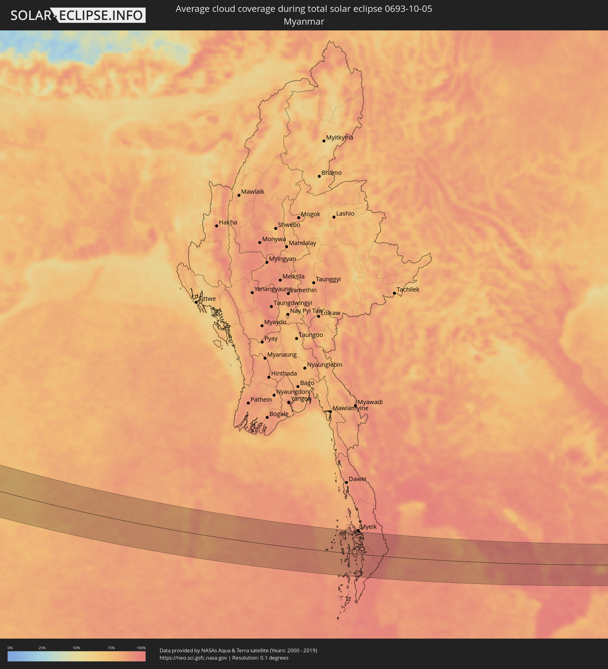 Myanmar
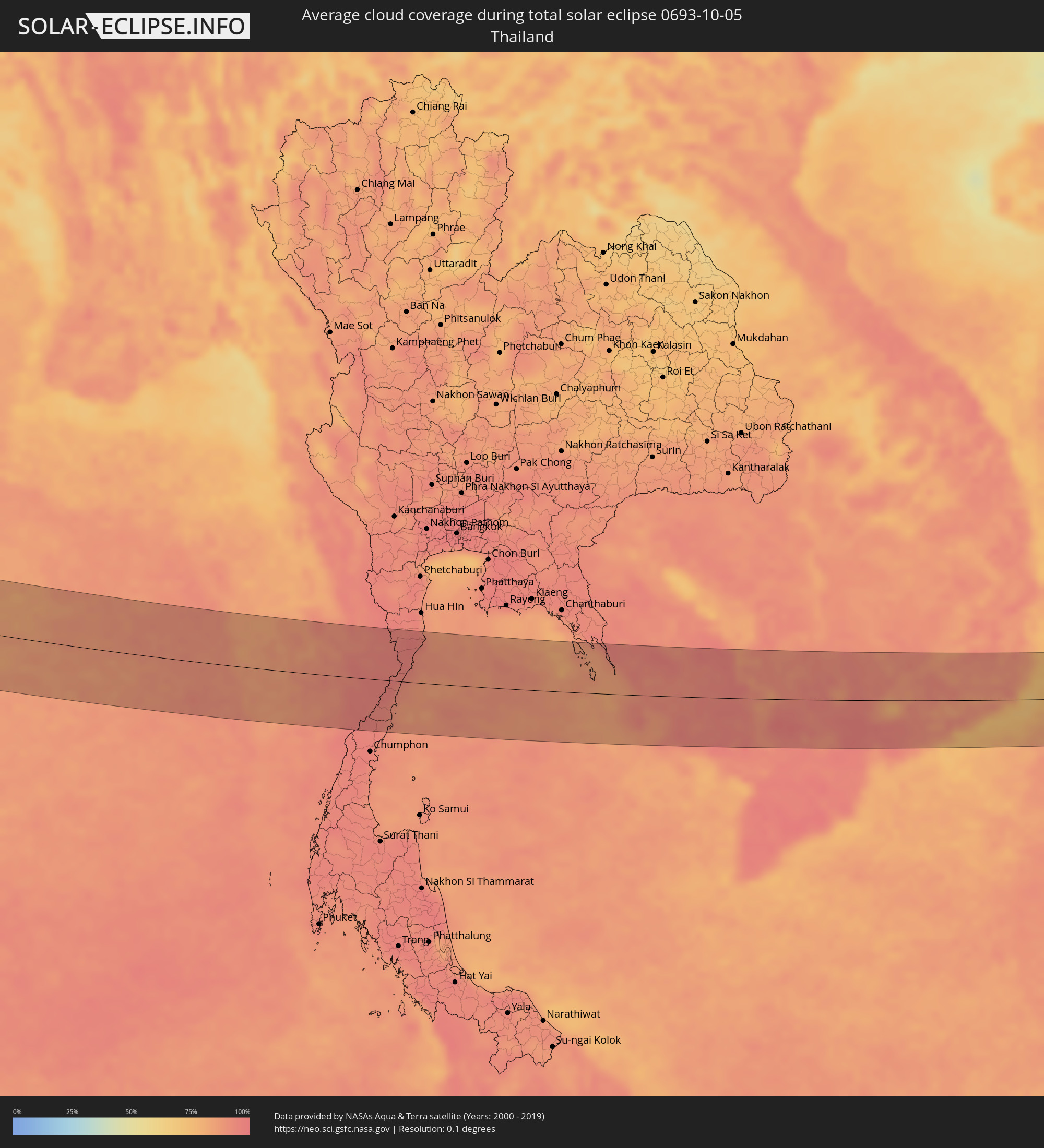 Thailand
 Vietnam
 Cambodia
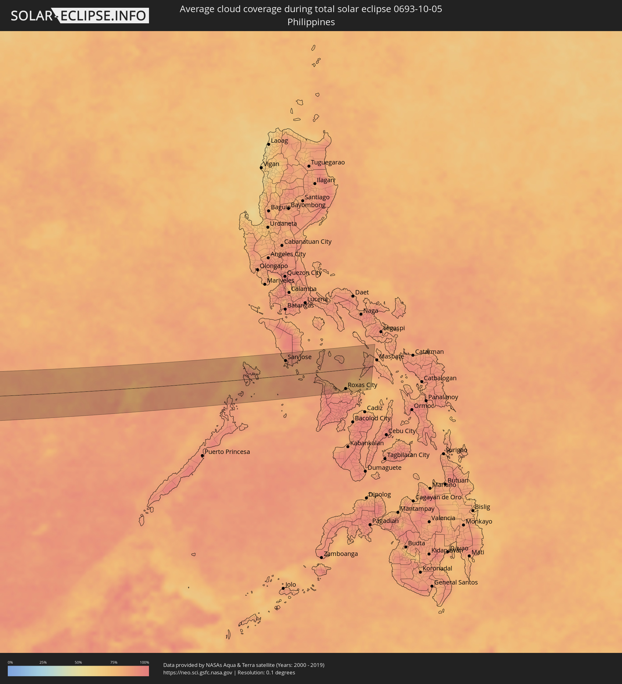 Philippines
Cities inside the path of the eclipse
The following table shows all locations with a population of more than 5,000 inside the eclipse path. Cities which have more than 100,000 inhabitants are marked bold. A click at the locations opens a detailed map.
| City | Type | Eclipse duration | Local time of max. eclipse | Distance to central line | Ø Cloud coverage |
|
La Roche-sur-Yon, Pays de la Loire
|
total | - | 06:39:06 UTC+00:09 | 43 km | 81% |
|
La Rochelle, Nouvelle-Aquitaine
|
total | - | 06:38:44 UTC+00:09 | 9 km | 71% |
|
Poitiers, Nouvelle-Aquitaine
|
total | - | 06:39:19 UTC+00:09 | 57 km | 79% |
|
Limoges, Nouvelle-Aquitaine
|
total | - | 06:38:53 UTC+00:09 | 12 km | 73% |
|
Clermont-Ferrand, Auvergne-Rhône-Alpes
|
total | - | 06:39:15 UTC+00:09 | 9 km | 73% |
|
Saint-Étienne, Auvergne-Rhône-Alpes
|
total | - | 06:39:19 UTC+00:09 | 8 km | 68% |
|
Lyon, Auvergne-Rhône-Alpes
|
total | - | 06:39:42 UTC+00:09 | 34 km | 73% |
|
Valence, Auvergne-Rhône-Alpes
|
total | - | 06:39:05 UTC+00:09 | 54 km | 67% |
|
Grenoble, Auvergne-Rhône-Alpes
|
total | - | 06:39:30 UTC+00:09 | 15 km | 67% |
|
Chambéry, Auvergne-Rhône-Alpes
|
total | - | 06:39:53 UTC+00:09 | 32 km | 68% |
|
Turin, Piedmont
|
total | - | 07:30:45 UTC+01:00 | 9 km | 69% |
|
Genoa, Liguria
|
total | - | 07:30:44 UTC+01:00 | 38 km | 65% |
|
Parma, Emilia-Romagna
|
total | - | 07:31:35 UTC+01:00 | 29 km | 69% |
|
Reggio nell'Emilia, Emilia-Romagna
|
total | - | 07:31:38 UTC+01:00 | 24 km | 68% |
|
Modena, Emilia-Romagna
|
total | - | 07:31:44 UTC+01:00 | 24 km | 68% |
|
Prato, Tuscany
|
total | - | 07:31:16 UTC+01:00 | 55 km | 66% |
|
Florence, Tuscany
|
total | - | 07:31:16 UTC+01:00 | 63 km | 64% |
|
Bologna, Emilia-Romagna
|
total | - | 07:31:48 UTC+01:00 | 16 km | 66% |
|
Forlì, Emilia-Romagna
|
total | - | 07:31:57 UTC+01:00 | 1 km | 68% |
|
Acquaviva, Acquaviva
|
total | - | 07:31:56 UTC+01:00 | 21 km | 71% |
|
Poggio di Chiesanuova, Chiesanuova
|
total | - | 07:31:54 UTC+01:00 | 25 km | 71% |
|
San Marino, San Marino
|
total | - | 07:31:56 UTC+01:00 | 21 km | 71% |
|
Borgo Maggiore, Borgo Maggiore
|
total | - | 07:31:57 UTC+01:00 | 21 km | 71% |
|
Fiorentino, Fiorentino
|
total | - | 07:31:56 UTC+01:00 | 24 km | 71% |
|
Domagnano, Domagnano
|
total | - | 07:31:58 UTC+01:00 | 19 km | 71% |
|
Serravalle, Serravalle
|
total | - | 07:31:59 UTC+01:00 | 17 km | 68% |
|
Monte Giardino, Montegiardino
|
total | - | 07:31:56 UTC+01:00 | 23 km | 71% |
|
Faetano, Faetano
|
total | - | 07:31:58 UTC+01:00 | 21 km | 71% |
|
Rimini, Emilia-Romagna
|
total | - | 07:32:05 UTC+01:00 | 6 km | 58% |
|
Zadar, Zadarska
|
total | - | 07:33:32 UTC+01:00 | 59 km | 55% |
|
Šibenik, Šibensko-Kniniska
|
total | - | 07:33:39 UTC+01:00 | 32 km | 61% |
|
Knin, Šibensko-Kniniska
|
total | - | 07:34:02 UTC+01:00 | 73 km | 61% |
|
Trogir, Splitsko-Dalmatinska
|
total | - | 07:33:43 UTC+01:00 | 17 km | 56% |
|
Split, Splitsko-Dalmatinska
|
total | - | 07:33:50 UTC+01:00 | 21 km | 57% |
|
Podstrana, Splitsko-Dalmatinska
|
total | - | 07:33:53 UTC+01:00 | 22 km | 61% |
|
Sinj, Splitsko-Dalmatinska
|
total | - | 07:34:05 UTC+01:00 | 47 km | 64% |
|
Livno, Federation of Bosnia and Herzegovina
|
total | - | 07:34:23 UTC+01:00 | 69 km | 64% |
|
Makarska, Splitsko-Dalmatinska
|
total | - | 07:34:03 UTC+01:00 | 13 km | 58% |
|
Tomislavgrad, Federation of Bosnia and Herzegovina
|
total | - | 07:34:27 UTC+01:00 | 62 km | 66% |
|
Ljubuški, Federation of Bosnia and Herzegovina
|
total | - | 07:34:19 UTC+01:00 | 15 km | 54% |
|
Široki Brijeg, Federation of Bosnia and Herzegovina
|
total | - | 07:34:28 UTC+01:00 | 35 km | 62% |
|
Metković, Dubrovačko-Neretvanska
|
total | - | 07:34:18 UTC+01:00 | 2 km | 56% |
|
Čapljina, Federation of Bosnia and Herzegovina
|
total | - | 07:34:22 UTC+01:00 | 10 km | 57% |
|
Mostar, Federation of Bosnia and Herzegovina
|
total | - | 07:34:35 UTC+01:00 | 36 km | 60% |
|
Stolac, Federation of Bosnia and Herzegovina
|
total | - | 07:34:31 UTC+01:00 | 13 km | 59% |
|
Konjic, Federation of Bosnia and Herzegovina
|
total | - | 07:34:52 UTC+01:00 | 73 km | 64% |
|
Dubrovnik, Dubrovačko-Neretvanska
|
total | - | 07:34:21 UTC+01:00 | 30 km | 59% |
|
Trebinje, Republic of Srspka
|
total | - | 07:34:33 UTC+01:00 | 17 km | 64% |
|
Bileća, Republic of Srspka
|
total | - | 07:34:42 UTC+01:00 | 2 km | 61% |
|
Herceg-Novi, Herceg Novi
|
total | - | 07:34:32 UTC+01:00 | 40 km | 66% |
|
Kotor, Kotor
|
total | - | 07:34:40 UTC+01:00 | 38 km | 70% |
|
Dobrota
|
total | - | 07:34:41 UTC+01:00 | 34 km | 68% |
|
Budva, Budva
|
total | - | 07:34:38 UTC+01:00 | 50 km | 61% |
|
Nikšić, Opština Nikšić
|
total | - | 07:34:59 UTC+01:00 | 4 km | 59% |
|
Bar, Bar
|
total | - | 07:34:43 UTC+01:00 | 64 km | 59% |
|
Podgorica, Podgorica
|
total | - | 07:35:01 UTC+01:00 | 23 km | 56% |
|
Shkodër, Shkodër
|
total | - | 07:54:19 UTC+01:19 | 56 km | 55% |
|
Bijelo Polje, Bijelo Polje
|
total | - | 07:35:42 UTC+01:00 | 52 km | 66% |
|
Berane, Berane
|
total | - | 07:35:40 UTC+01:00 | 35 km | 62% |
|
Pukë, Shkodër
|
total | - | 07:54:35 UTC+01:19 | 49 km | 63% |
|
Rožaje, Opština Rožaje
|
total | - | 07:35:52 UTC+01:00 | 41 km | 66% |
|
Kukës, Kukës
|
total | - | 07:54:58 UTC+01:19 | 32 km | 58% |
|
Peshkopi, Dibër
|
total | - | 07:54:46 UTC+01:19 | 73 km | 54% |
|
Gostivar, Gostivar
|
total | - | 07:35:51 UTC+01:00 | 49 km | 56% |
|
Tetovo, Tetovo
|
total | - | 07:36:01 UTC+01:00 | 24 km | 59% |
|
Skopje, Karpoš
|
total | - | 07:36:21 UTC+01:00 | 13 km | 53% |
|
Kumanovo, Kumanovo
|
total | - | 07:36:38 UTC+01:00 | 8 km | 49% |
|
Veles, Veles
|
total | - | 07:36:28 UTC+01:00 | 34 km | 51% |
|
Vranje, Central Serbia
|
total | - | 07:37:00 UTC+01:00 | 58 km | 56% |
|
Kavadarci, Kavadarci
|
total | - | 07:36:31 UTC+01:00 | 57 km | 50% |
|
Shtip, Štip
|
total | - | 07:36:49 UTC+01:00 | 19 km | 50% |
|
Kochani, Kočani
|
total | - | 07:37:04 UTC+01:00 | 5 km | 55% |
|
Радовиш, Radoviš
|
total | - | 07:36:59 UTC+01:00 | 23 km | 50% |
|
Strumica, Strumica
|
total | - | 07:37:01 UTC+01:00 | 39 km | 51% |
|
Kyustendil, Kyustendil
|
total | - | 08:37:29 UTC+02:00 | 51 km | 53% |
|
Blagoevgrad, Blagoevgrad
|
total | - | 08:37:40 UTC+02:00 | 34 km | 47% |
|
Dupnitsa, Kyustendil
|
total | - | 08:37:49 UTC+02:00 | 61 km | 52% |
|
Petrich, Blagoevgrad
|
total | - | 08:37:28 UTC+02:00 | 27 km | 52% |
|
Sandanski, Blagoevgrad
|
total | - | 08:37:36 UTC+02:00 | 8 km | 49% |
|
Sidirókastro, Central Macedonia
|
total | - | 08:12:24 UTC+01:34 | 39 km | 55% |
|
Sérres, Central Macedonia
|
total | - | 08:12:28 UTC+01:34 | 51 km | 54% |
|
Gotse Delchev, Blagoevgrad
|
total | - | 08:37:59 UTC+02:00 | 5 km | 52% |
|
Velingrad, Pazardzhik
|
total | - | 08:38:25 UTC+02:00 | 61 km | 55% |
|
Dráma, East Macedonia and Thrace
|
total | - | 08:13:00 UTC+01:34 | 26 km | 50% |
|
Peshtera, Pazardzhik
|
total | - | 08:38:40 UTC+02:00 | 70 km | 54% |
|
Kavála, East Macedonia and Thrace
|
total | - | 08:13:08 UTC+01:34 | 41 km | 48% |
|
Smolyan, Smolyan
|
total | - | 08:38:48 UTC+02:00 | 35 km | 57% |
|
Chrysoúpolis, East Macedonia and Thrace
|
total | - | 08:13:24 UTC+01:34 | 28 km | 60% |
|
Xánthi, East Macedonia and Thrace
|
total | - | 08:13:38 UTC+01:34 | 7 km | 61% |
|
Kardzhali, Kŭrdzhali
|
total | - | 08:39:25 UTC+02:00 | 61 km | 53% |
|
Komotiní, East Macedonia and Thrace
|
total | - | 08:14:05 UTC+01:34 | 7 km | 60% |
|
Alexandroúpoli, East Macedonia and Thrace
|
total | - | 08:14:24 UTC+01:34 | 7 km | 51% |
|
Féres, East Macedonia and Thrace
|
total | - | 08:14:41 UTC+01:34 | 6 km | 60% |
|
Didymóteicho, East Macedonia and Thrace
|
total | - | 08:15:10 UTC+01:34 | 63 km | 51% |
|
Balıkesir, Balıkesir
|
total | - | 08:37:56 UTC+01:56 | 70 km | 46% |
|
Bursa, Bursa
|
total | - | 08:39:18 UTC+01:56 | 24 km | 47% |
|
Kütahya, Kütahya
|
total | - | 08:40:02 UTC+01:56 | 25 km | 38% |
|
Eskişehir, Eskişehir
|
total | - | 08:40:42 UTC+01:56 | 29 km | 38% |
|
Aksaray, Aksaray
|
total | - | 08:44:25 UTC+01:56 | 9 km | 22% |
|
Adana, Adana
|
total | - | 08:45:55 UTC+01:56 | 82 km | 28% |
|
Osmaniye, Osmaniye
|
total | - | 08:47:07 UTC+01:56 | 40 km | 30% |
|
‘Afrīn, Aleppo
|
total | - | 09:16:12 UTC+02:25 | 72 km | 20% |
|
Kahramanmaraş, Kahramanmaraş
|
total | - | 08:48:02 UTC+01:56 | 38 km | 22% |
|
I‘zāz, Aleppo
|
total | - | 09:16:26 UTC+02:25 | 58 km | 19% |
|
Gaziantep, Gaziantep
|
total | - | 08:48:38 UTC+01:56 | 3 km | 19% |
|
Al Bāb, Aleppo
|
total | - | 09:17:05 UTC+02:25 | 61 km | 18% |
|
Manbij, Aleppo
|
total | - | 09:17:41 UTC+02:25 | 28 km | 17% |
|
‘Ayn al ‘Arab, Aleppo
|
total | - | 09:18:14 UTC+02:25 | 24 km | 18% |
|
Ath Thawrah, Ar-Raqqah
|
total | - | 09:18:33 UTC+02:25 | 73 km | 14% |
|
Şanlıurfa, Şanlıurfa
|
total | - | 08:50:34 UTC+01:56 | 69 km | 20% |
|
Ar Raqqah, Ar-Raqqah
|
total | - | 09:19:12 UTC+02:25 | 43 km | 15% |
|
Deir ez-Zor, Deir ez-Zor
|
total | - | 09:20:55 UTC+02:25 | 58 km | 9% |
|
Al Mayādīn, Deir ez-Zor
|
total | - | 09:21:26 UTC+02:25 | 76 km | 16% |
|
Al Ḩasakah, Al-Hasakah
|
total | - | 09:21:41 UTC+02:25 | 83 km | 12% |
|
Tikrīt, Salah ad Din Governorate
|
total | - | 09:58:58 UTC+02:57 | 23 km | 13% |
|
Sāmarrā’, Salah ad Din Governorate
|
total | - | 09:59:25 UTC+02:57 | 9 km | 13% |
|
Balad, Salah ad Din Governorate
|
total | - | 09:59:54 UTC+02:57 | 15 km | 14% |
|
Abū Ghurayb, Mayorality of Baghdad
|
total | - | 10:00:12 UTC+02:57 | 82 km | 13% |
|
Baghdad, Mayorality of Baghdad
|
total | - | 10:00:33 UTC+02:57 | 69 km | 12% |
|
Baqubah, Diyālá
|
total | - | 10:00:45 UTC+02:57 | 20 km | 13% |
|
Al Miqdādīyah, Diyālá
|
total | - | 10:01:14 UTC+02:57 | 17 km | 14% |
|
Al ‘Azīzīyah, Wāsiţ
|
total | - | 10:01:50 UTC+02:57 | 81 km | 12% |
|
Al Kūt, Wāsiţ
|
total | - | 10:03:18 UTC+02:57 | 85 km | 12% |
|
Īlām, Īlām
|
total | - | 10:32:01 UTC+03:25 | 52 km | 15% |
|
Al ‘Amārah, Maysan
|
total | - | 10:05:58 UTC+02:57 | 88 km | 6% |
|
Ahvaz, Khuzestan
|
total | - | 10:37:12 UTC+03:25 | 64 km | 6% |
|
Masjed Soleymān, Khuzestan
|
total | - | 10:38:00 UTC+03:25 | 25 km | 6% |
|
Dogonbadan, Kohgīlūyeh va Būyer Aḩmad
|
total | - | 10:41:50 UTC+03:25 | 52 km | 1% |
|
Yasuj, Kohgīlūyeh va Būyer Aḩmad
|
total | - | 10:43:10 UTC+03:25 | 17 km | 5% |
|
Kāzerūn, Fars
|
total | - | 10:44:02 UTC+03:25 | 79 km | 1% |
|
Shiraz, Fars
|
total | - | 10:45:49 UTC+03:25 | 36 km | 3% |
|
Akbarābād, Fars
|
total | - | 10:46:36 UTC+03:25 | 58 km | 3% |
|
Fasā, Fars
|
total | - | 10:48:37 UTC+03:25 | 42 km | 2% |
|
Bandar Abbas, Hormozgan
|
total | - | 10:55:47 UTC+03:25 | 70 km | 9% |
|
Jīwani, Balochistān
|
total | - | 12:12:51 UTC+04:28 | 23 km | 26% |
|
Gwadar, Balochistān
|
total | - | 12:14:06 UTC+04:28 | 61 km | 30% |
|
Bhayandar, Maharashtra
|
total | - | 13:39:49 UTC+05:21 | 54 km | 62% |
|
Mumbai, Maharashtra
|
total | - | 13:40:13 UTC+05:21 | 33 km | 64% |
|
Thāne, Maharashtra
|
total | - | 13:40:14 UTC+05:21 | 50 km | 63% |
|
Kalyān, Maharashtra
|
total | - | 13:40:33 UTC+05:21 | 62 km | 61% |
|
Pune, Maharashtra
|
total | - | 13:43:17 UTC+05:21 | 25 km | 62% |
|
Bijapur, Karnataka
|
total | - | 13:50:02 UTC+05:21 | 60 km | 67% |
|
Solāpur, Maharashtra
|
total | - | 13:49:14 UTC+05:21 | 34 km | 67% |
|
Gulbarga, Karnataka
|
total | - | 13:51:48 UTC+05:21 | 41 km | 70% |
|
Rāichūr, Karnataka
|
total | - | 13:54:36 UTC+05:21 | 52 km | 79% |
|
Guntur, Andhra Pradesh
|
total | - | 14:01:06 UTC+05:21 | 81 km | 84% |
|
Bang Saphan, Prachuap Khiri Khan
|
total | - | 15:58:49 UTC+06:42 | 38 km | 92% |
|
Prachuap Khiri Khan, Prachuap Khiri Khan
|
total | - | 15:58:27 UTC+06:42 | 32 km | 93% |
|
Kui Buri, Prachuap Khiri Khan
|
total | - | 15:58:15 UTC+06:42 | 61 km | 93% |
|
Sam Roi Yot, Prachuap Khiri Khan
|
total | - | 15:58:03 UTC+06:42 | 82 km | 96% |
|
Koh Kong, Koh Kong
|
total | - | 16:01:49 UTC+06:42 | 29 km | 85% |
|
Sihanoukville, Preah Sihanouk
|
total | - | 16:03:20 UTC+06:42 | 80 km | 86% |
|
Kampong Speu, Kampong Speu
|
total | - | 16:03:20 UTC+06:42 | 17 km | 94% |
|
Phumĭ Véal Srê, Takeo
|
total | - | 16:04:01 UTC+06:42 | 35 km | 92% |
|
Takeo, Takeo
|
total | - | 16:04:01 UTC+06:42 | 34 km | 92% |
|
Phnom Penh, Phnom Penh
|
total | - | 16:03:32 UTC+06:42 | 30 km | 95% |
|
Ta Khmau, Kandal
|
total | - | 16:03:39 UTC+06:42 | 22 km | 91% |
|
Prey Veng, Prey Veng
|
total | - | 16:03:57 UTC+06:42 | 23 km | 85% |
|
Kampong Cham, Kampong Cham
|
total | - | 16:03:32 UTC+06:42 | 79 km | 90% |
|
Suŏng, Tboung Khmum
|
total | - | 16:03:47 UTC+06:42 | 71 km | 90% |
|
Ho Chi Minh City, Ho Chi Minh City
|
total | - | 16:30:11 UTC+07:06 | 49 km | 97% |
|
Thủ Dầu Một, Bình Dương
|
total | - | 16:30:03 UTC+07:06 | 32 km | 97% |
|
Cần Giuộc, Long An
|
total | - | 16:30:26 UTC+07:06 | 73 km | 94% |
|
Biên Hòa, Đồng Nai
|
total | - | 16:30:13 UTC+07:06 | 36 km | 95% |
|
La Gi, Bình Thuận
|
total | - | 16:31:09 UTC+07:06 | 67 km | 81% |
|
Bảo Lộc, Lâm Đồng
|
total | - | 16:30:19 UTC+07:06 | 32 km | 91% |
|
Phan Thiết, Bình Thuận
|
total | - | 16:31:07 UTC+07:06 | 37 km | 78% |
|
Ðà Lạt, Lâm Đồng
|
total | - | 16:30:21 UTC+07:06 | 76 km | 90% |
|
Phan Rang-Tháp Chàm, Ninh Thuận
|
total | - | 16:31:04 UTC+07:06 | 32 km | 88% |
|
Cam Ranh, Khánh Hòa
|
total | - | 16:30:50 UTC+07:06 | 72 km | 85% |
|
El Nido, Mimaropa
|
total | - | 17:29:05 UTC+08:00 | 68 km | 87% |
|
Coron, Mimaropa
|
total | - | 17:28:33 UTC+08:00 | 14 km | 83% |
|
San Jose, Mimaropa
|
total | - | 17:28:25 UTC+08:00 | 45 km | 83% |
|
Bulalacao, Mimaropa
|
total | - | 17:28:29 UTC+08:00 | 39 km | 80% |
|
Mansalay, Mimaropa
|
total | - | 17:28:20 UTC+08:00 | 60 km | 84% |
|
Pandan, Western Visayas
|
total | - | 17:29:05 UTC+08:00 | 33 km | 89% |
|
Romblon, Mimaropa
|
total | - | 17:28:24 UTC+08:00 | 57 km | 80% |
|
Kalibo (poblacion), Western Visayas
|
total | - | 17:29:09 UTC+08:00 | 41 km | 84% |
|
Roxas City, Western Visayas
|
total | - | 17:29:17 UTC+08:00 | 58 km | 86% |
|
Guinticgan, Western Visayas
|
total | - | 17:29:21 UTC+08:00 | 65 km | 80% |