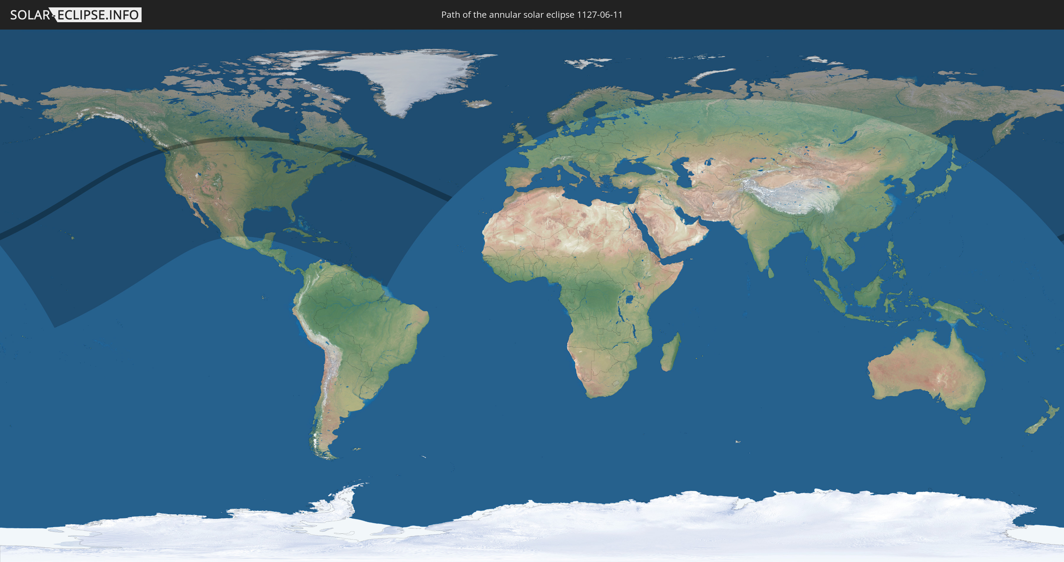
Annular solar eclipse of 06/11/1127
| Day of week: | Saturday |
| Maximum duration of eclipse: | 03m10s |
| Maximum width of eclipse path: | 138 km |
| Saros cycle: | 113 |
| Coverage: | 96.6% |
| Magnitude: | 0.9664 |
| Gamma: | 0.4756 |
Wo kann man die Sonnenfinsternis vom 06/11/1127 sehen?
Die Sonnenfinsternis am 06/11/1127 kann man in 52 Ländern als partielle Sonnenfinsternis beobachten.
Der Finsternispfad verläuft durch ein Land. Nur in diesem Land ist sie als annular Sonnenfinsternis zu sehen.
In den folgenden Ländern ist die Sonnenfinsternis annular zu sehen
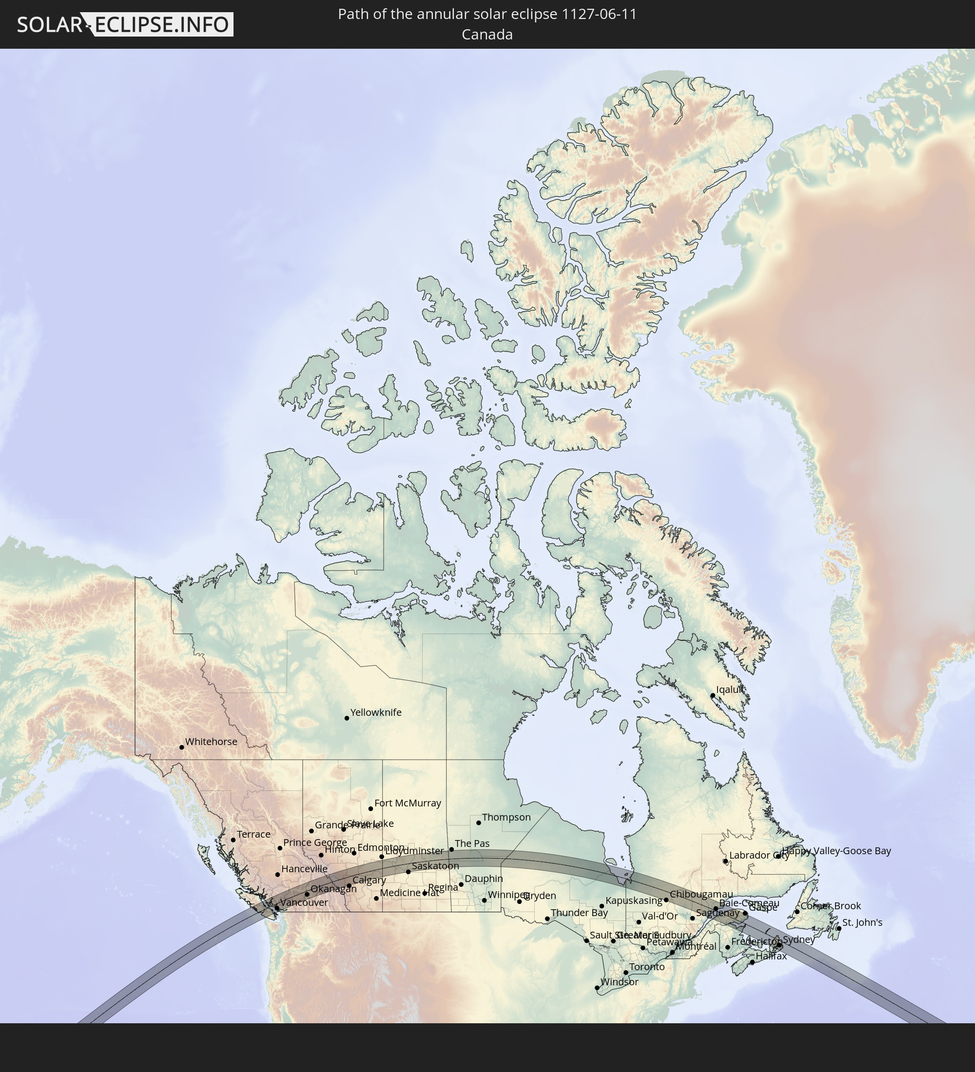 Canada
In den folgenden Ländern ist die Sonnenfinsternis partiell zu sehen
 Russia
 United States
 United States Minor Outlying Islands
 Kiribati
 Cook Islands
 Canada
 Mexico
 Greenland
 Cuba
Cuba
 Cayman Islands
 The Bahamas
 Jamaica
 Haiti
Haiti
 Brazil
 Venezuela
 Turks and Caicos Islands
 Dominican Republic
 Aruba
Aruba
 Puerto Rico
 United States Virgin Islands
 Bermuda
 British Virgin Islands
 Anguilla
 Collectivity of Saint Martin
 Saint Barthélemy
 Saint Kitts and Nevis
 Antigua and Barbuda
 Montserrat
 Trinidad and Tobago
 Guadeloupe
 Grenada
 Dominica
 Saint Vincent and the Grenadines
 Guyana
 Martinique
 Saint Lucia
 Barbados
 Suriname
 Saint Pierre and Miquelon
 French Guiana
 Portugal
 Iceland
 Republic of Ireland
 Svalbard and Jan Mayen
 United Kingdom
 Faroe Islands
 Isle of Man
 Norway
 Denmark
 Sweden
 Åland Islands
 Finland
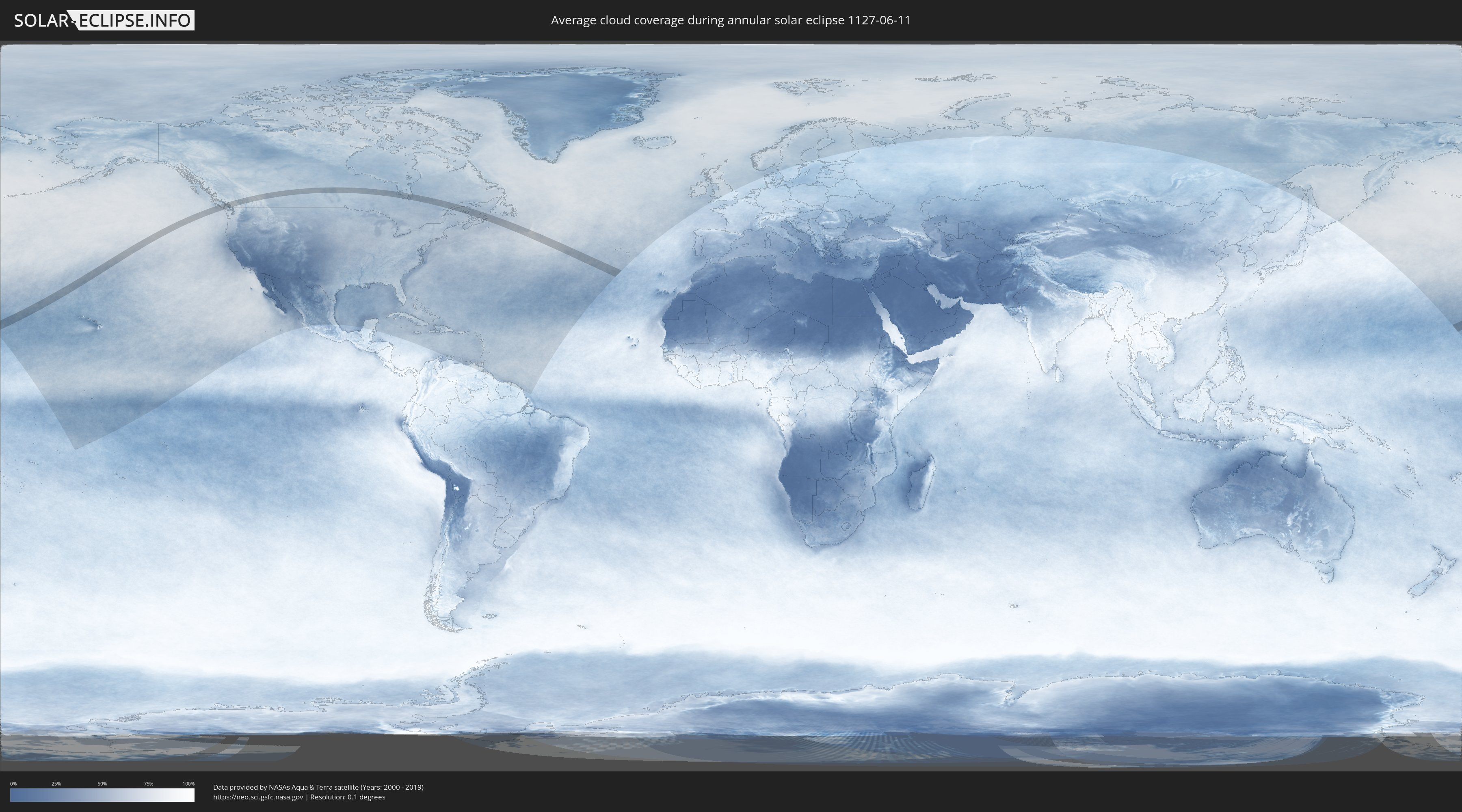
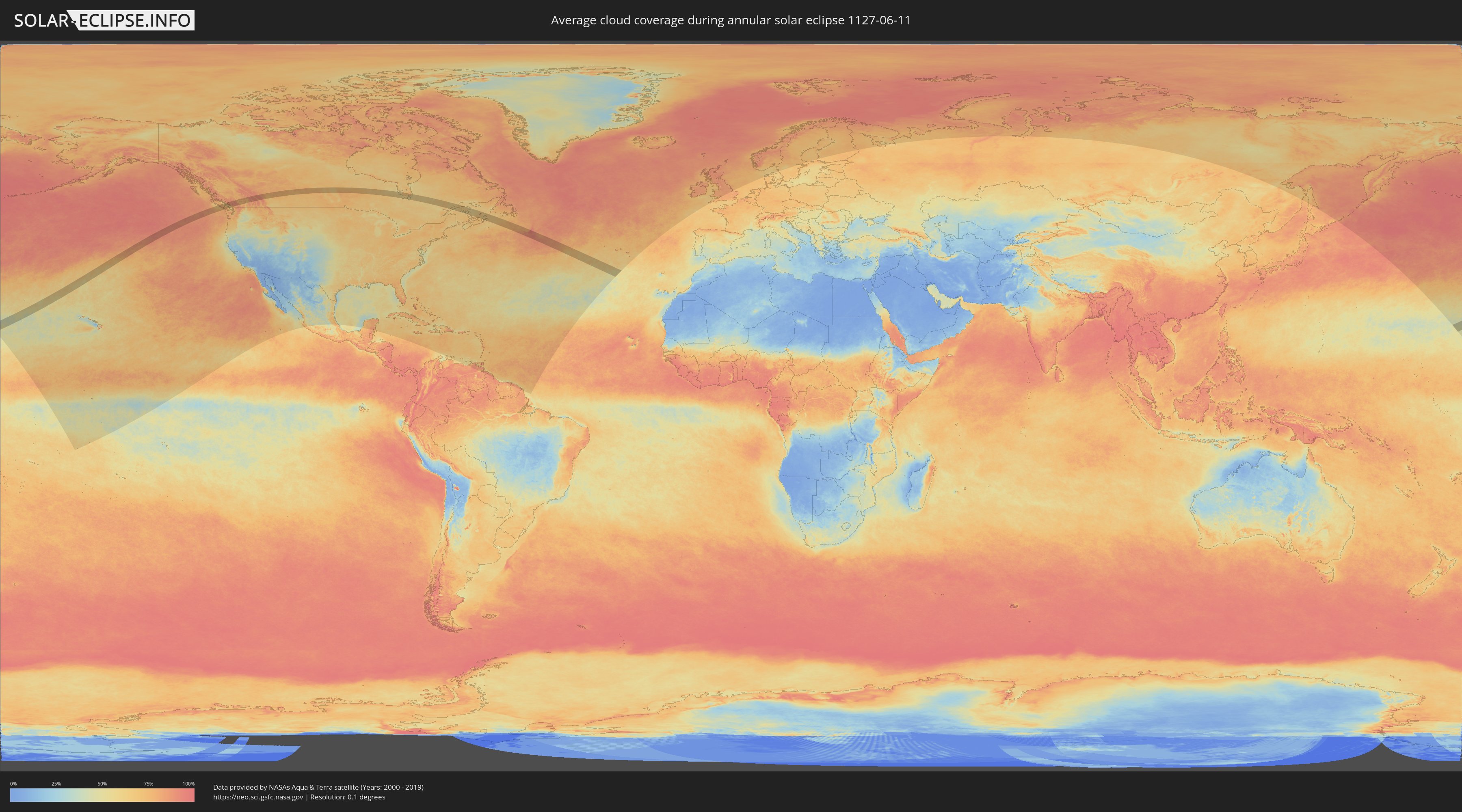
How will be the weather during the annular solar eclipse on 06/11/1127?
Where is the best place to see the annular solar eclipse of 06/11/1127?
The following maps show the average cloud coverage for the day of the annular solar eclipse.
With the help of these maps, it is possible to find the place along the eclipse path, which has the best
chance of a cloudless sky.
Nevertheless, you should consider local circumstances and inform about the weather of your chosen
observation site.
The data is provided by NASAs satellites
AQUA and TERRA.
The cloud maps are averaged over a period of 19 years (2000 - 2019).
Detailed country maps
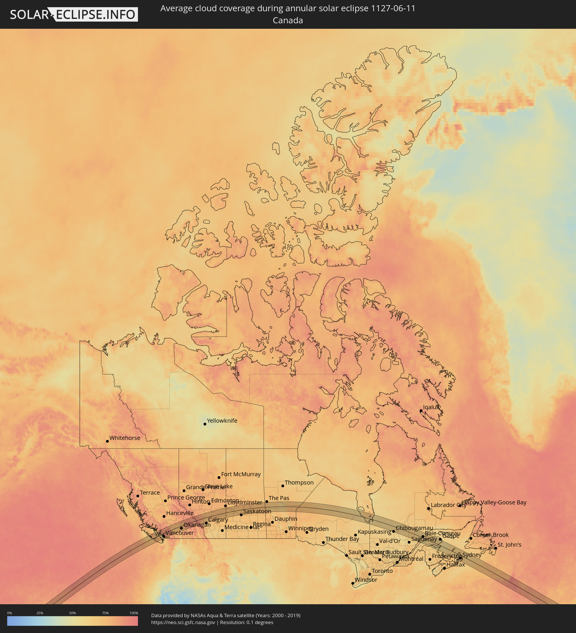 Canada
Cities inside the path of the eclipse
The following table shows all locations with a population of more than 5,000 inside the eclipse path. Cities which have more than 100,000 inhabitants are marked bold. A click at the locations opens a detailed map.
| City | Type | Eclipse duration | Local time of max. eclipse | Distance to central line | Ø Cloud coverage |
|
Courtenay, British Columbia
|
annular | - | 10:52:20 UTC-08:00 | 57 km | 67% |
|
Port Alberni, British Columbia
|
annular | - | 10:52:01 UTC-08:00 | 19 km | 72% |
|
Powell River, British Columbia
|
annular | - | 10:53:17 UTC-08:00 | 57 km | 64% |
|
Parksville, British Columbia
|
annular | - | 10:52:55 UTC-08:00 | 14 km | 68% |
|
Nanaimo, British Columbia
|
annular | - | 10:53:19 UTC-08:00 | 31 km | 66% |
|
Ladysmith, British Columbia
|
annular | - | 10:53:17 UTC-08:00 | 52 km | 72% |
|
Sechelt, British Columbia
|
annular | - | 10:54:02 UTC-08:00 | 18 km | 64% |
|
Gibsons, British Columbia
|
annular | - | 10:54:21 UTC-08:00 | 22 km | 66% |
|
West Vancouver, British Columbia
|
annular | - | 10:54:52 UTC-08:00 | 35 km | 75% |
|
Richmond, British Columbia
|
annular | - | 10:54:39 UTC-08:00 | 54 km | 70% |
|
West End, British Columbia
|
annular | - | 10:54:49 UTC-08:00 | 44 km | 75% |
|
Vancouver, British Columbia
|
annular | - | 10:54:47 UTC-08:00 | 47 km | 70% |
|
Ladner, British Columbia
|
annular | - | 10:54:38 UTC-08:00 | 64 km | 67% |
|
North Vancouver, British Columbia
|
annular | - | 10:54:58 UTC-08:00 | 44 km | 75% |
|
Whistler, British Columbia
|
annular | - | 10:56:10 UTC-08:00 | 42 km | 85% |
|
Burnaby, British Columbia
|
annular | - | 10:55:05 UTC-08:00 | 53 km | 77% |
|
New Westminster, British Columbia
|
annular | - | 10:55:05 UTC-08:00 | 60 km | 75% |
|
Delta, British Columbia
|
annular | - | 10:55:00 UTC-08:00 | 66 km | 70% |
|
Anmore, British Columbia
|
annular | - | 10:55:19 UTC-08:00 | 49 km | 79% |
|
Port Moody, British Columbia
|
annular | - | 10:55:17 UTC-08:00 | 52 km | 79% |
|
Surrey, British Columbia
|
partial | - | 10:55:06 UTC-08:00 | 72 km | 72% |
|
Coquitlam, British Columbia
|
annular | - | 10:55:27 UTC-08:00 | 54 km | 79% |
|
Pitt Meadows, British Columbia
|
annular | - | 10:55:28 UTC-08:00 | 62 km | 79% |
|
Walnut Grove, British Columbia
|
annular | - | 10:55:29 UTC-08:00 | 69 km | 79% |
|
Maple Ridge, British Columbia
|
annular | - | 10:55:37 UTC-08:00 | 65 km | 79% |
|
Merritt, British Columbia
|
annular | - | 10:59:48 UTC-08:00 | 25 km | 70% |
|
Kamloops, British Columbia
|
annular | - | 11:01:14 UTC-08:00 | 26 km | 69% |
|
Okanagan, British Columbia
|
annular | - | 11:02:33 UTC-08:00 | 37 km | 71% |
|
Salmon Arm, British Columbia
|
annular | - | 11:03:00 UTC-08:00 | 14 km | 77% |
|
Vernon, British Columbia
|
annular | - | 11:02:35 UTC-08:00 | 49 km | 65% |
|
Revelstoke, British Columbia
|
annular | - | 11:05:12 UTC-08:00 | 14 km | 80% |
|
Banff, Alberta
|
annular | - | 11:36:04 UTC-07:33 | 43 km | 86% |
|
Canmore, Alberta
|
annular | - | 11:36:22 UTC-07:33 | 54 km | 84% |
|
Cochrane, Alberta
|
annular | - | 11:38:01 UTC-07:33 | 63 km | 72% |
|
Olds, Alberta
|
annular | - | 11:39:07 UTC-07:33 | 9 km | 71% |
|
Sylvan Lake, Alberta
|
annular | - | 11:39:33 UTC-07:33 | 54 km | 75% |
|
Airdrie, Alberta
|
annular | - | 11:38:53 UTC-07:33 | 59 km | 71% |
|
Red Deer, Alberta
|
annular | - | 11:40:00 UTC-07:33 | 44 km | 77% |
|
Lacombe, Alberta
|
annular | - | 11:40:15 UTC-07:33 | 63 km | 76% |
|
Stettler, Alberta
|
annular | - | 11:41:54 UTC-07:33 | 30 km | 75% |
|
Wainwright, Alberta
|
annular | - | 11:45:24 UTC-07:33 | 56 km | 78% |
|
North Battleford, Saskatchewan
|
annular | - | 12:25:04 UTC-06:58 | 22 km | 73% |
|
Prince Albert, Saskatchewan
|
annular | - | 12:29:32 UTC-06:58 | 36 km | 75% |
|
Melfort, Saskatchewan
|
annular | - | 12:31:28 UTC-06:58 | 16 km | 75% |
|
Chibougamau, Quebec
|
annular | - | 15:18:08 UTC-05:00 | 76 km | 62% |
|
Rimouski, Quebec
|
annular | - | 15:26:05 UTC-05:00 | 76 km | 59% |
|
Mont-Joli, Quebec
|
annular | - | 15:26:09 UTC-05:00 | 52 km | 57% |
|
Baie-Comeau, Quebec
|
annular | - | 15:25:13 UTC-05:00 | 23 km | 67% |
|
Matane, Quebec
|
annular | - | 15:26:21 UTC-05:00 | 7 km | 58% |
|
Amqui, Quebec
|
annular | - | 15:27:00 UTC-05:00 | 42 km | 61% |
|
Campbellton, New Brunswick
|
annular | - | 16:13:56 UTC-04:14 | 67 km | 61% |
|
Sainte-Anne-des-Monts, Quebec
|
annular | - | 15:26:44 UTC-05:00 | 53 km | 62% |
|
Bathurst, New Brunswick
|
annular | - | 16:15:21 UTC-04:14 | 76 km | 59% |
|
Chandler, Quebec
|
annular | - | 15:29:20 UTC-05:00 | 33 km | 65% |
|
Sydney Mines, Nova Scotia
|
annular | - | 16:21:13 UTC-04:14 | 34 km | 65% |
|
Sydney, Nova Scotia
|
annular | - | 16:21:24 UTC-04:14 | 43 km | 64% |
|
Glace Bay, Nova Scotia
|
annular | - | 16:21:26 UTC-04:14 | 34 km | 67% |