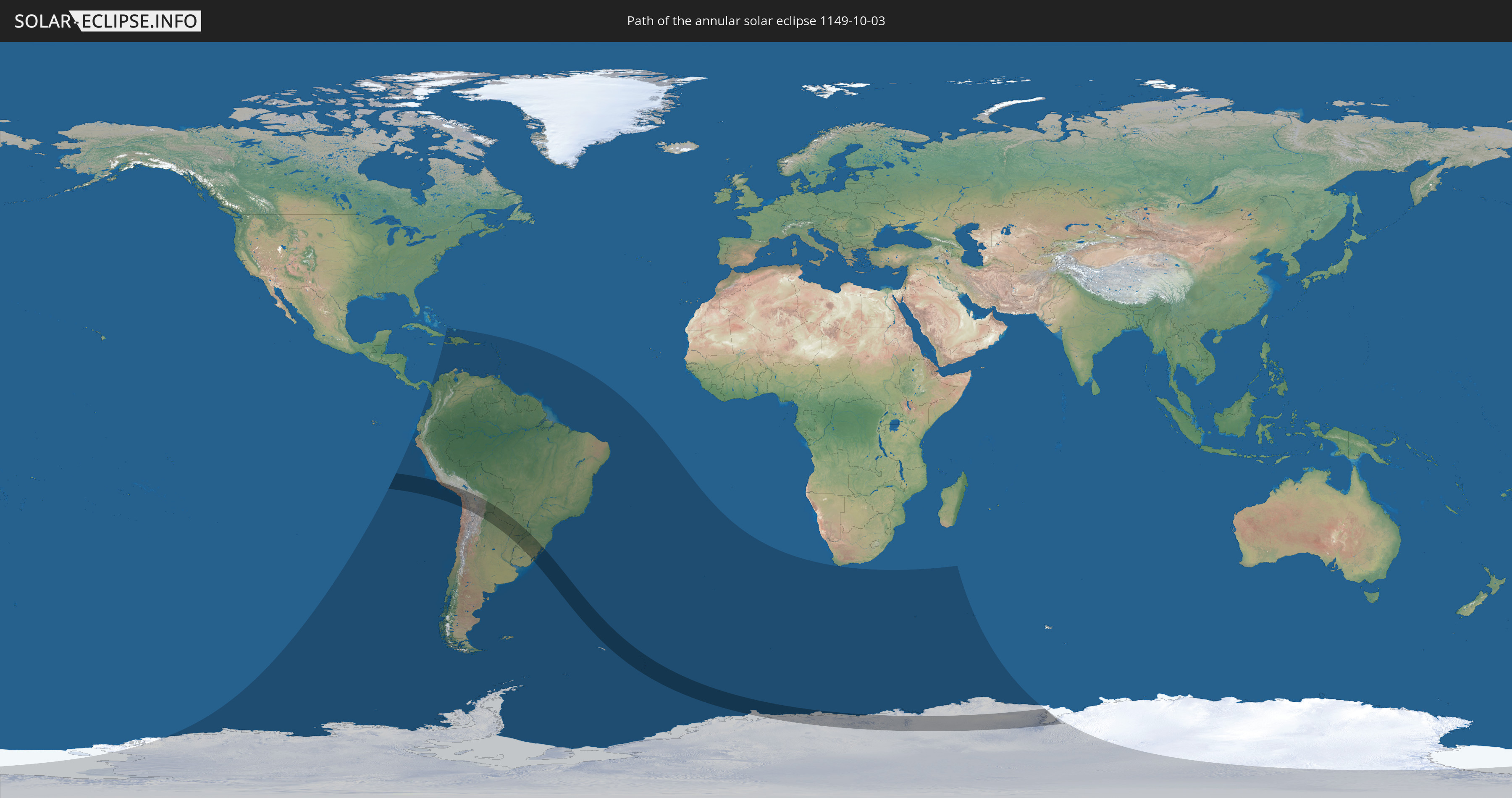
Annular solar eclipse of 10/03/1149
| Day of week: | Monday |
| Maximum duration of eclipse: | 06m24s |
| Maximum width of eclipse path: | 339 km |
| Saros cycle: | 120 |
| Coverage: | 93.2% |
| Magnitude: | 0.932 |
| Gamma: | -0.6802 |
Wo kann man die Sonnenfinsternis vom 10/03/1149 sehen?
Die Sonnenfinsternis am 10/03/1149 kann man in 42 Ländern als partielle Sonnenfinsternis beobachten.
Der Finsternispfad verläuft durch 9 Länder. Nur in diesen Ländern ist sie als annular Sonnenfinsternis zu sehen.
In den folgenden Ländern ist die Sonnenfinsternis annular zu sehen
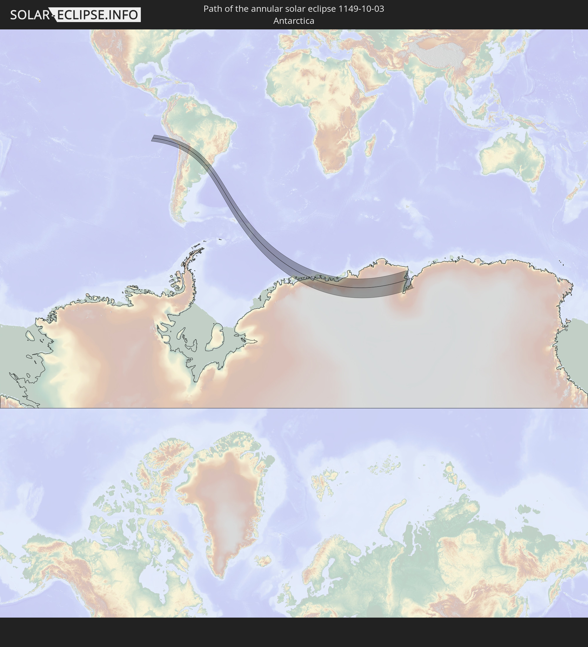 Antarctica
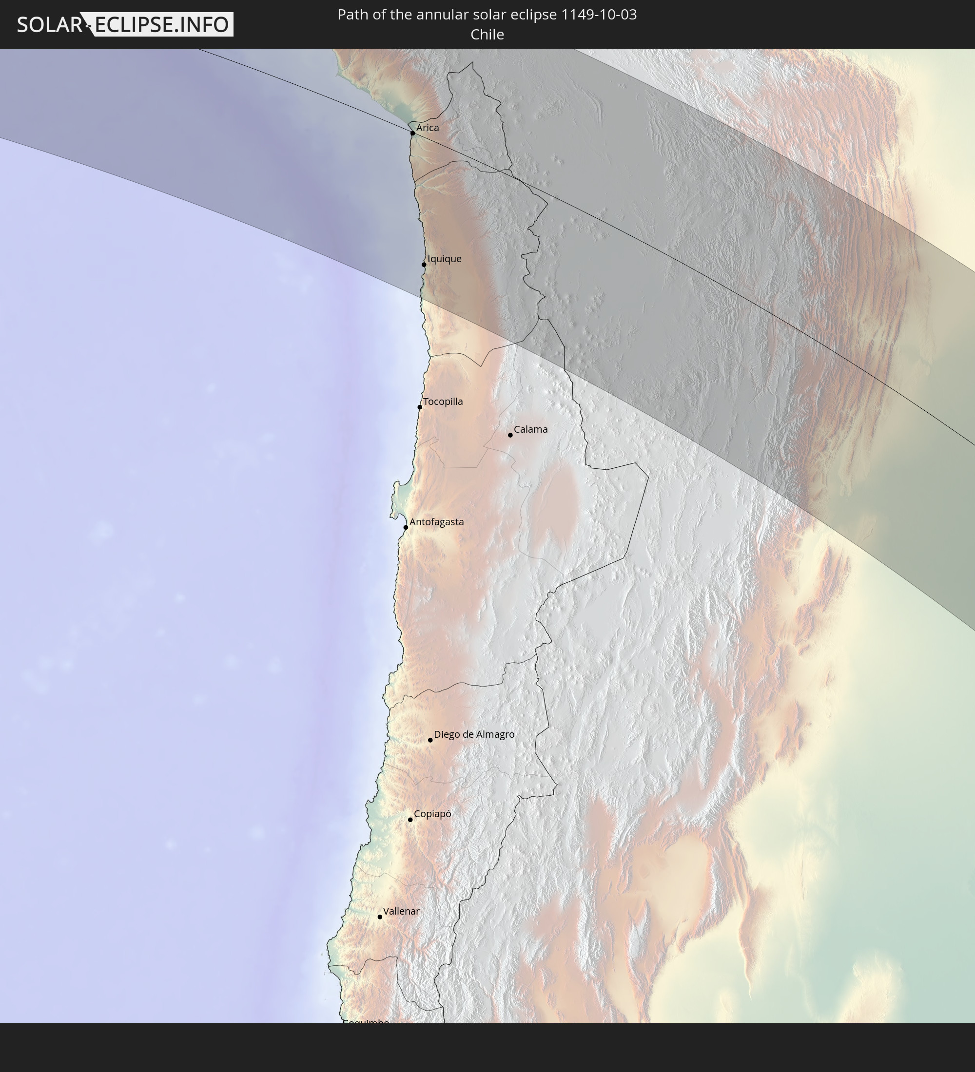 Chile
Chile
 Peru
Peru
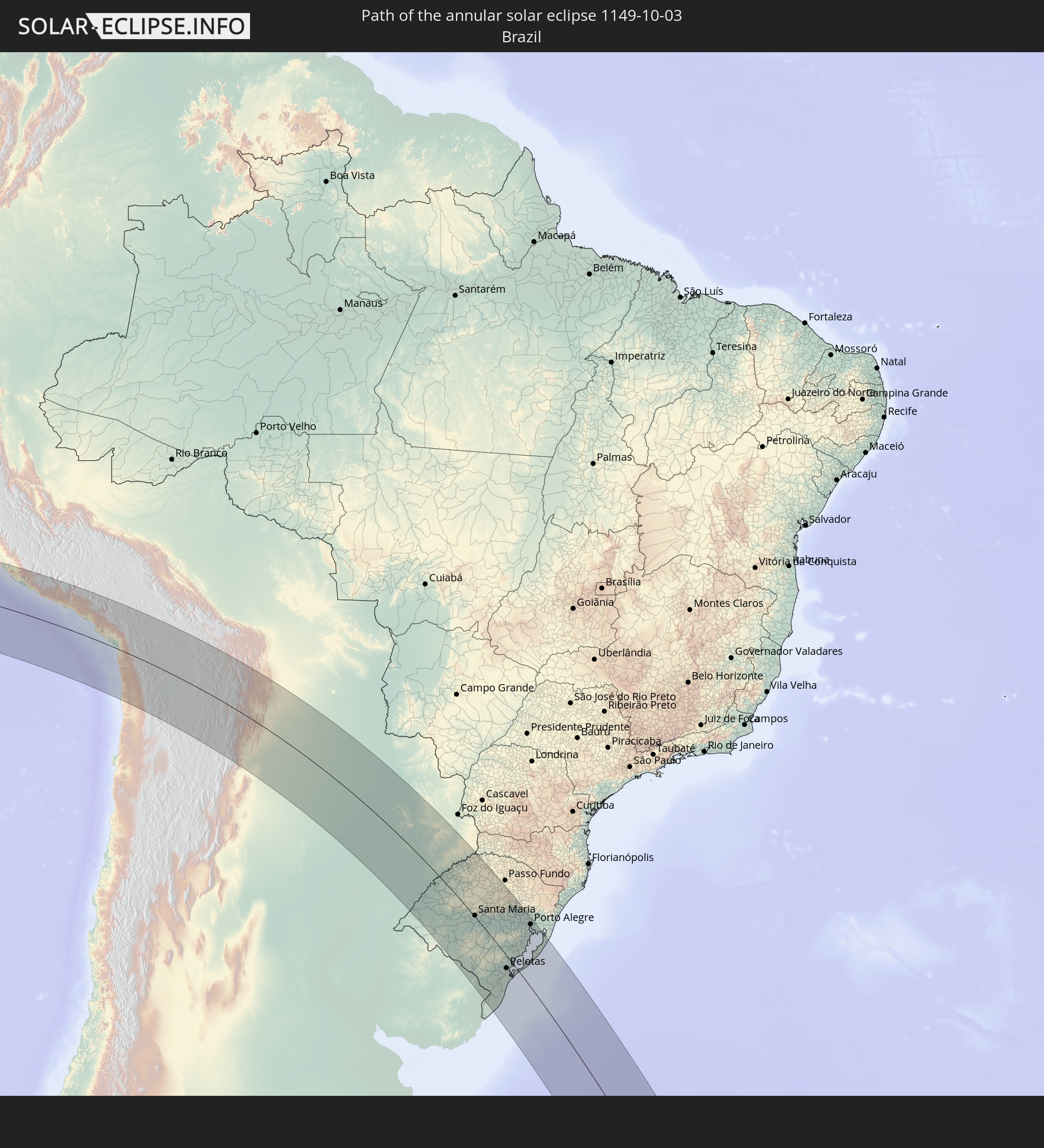 Brazil
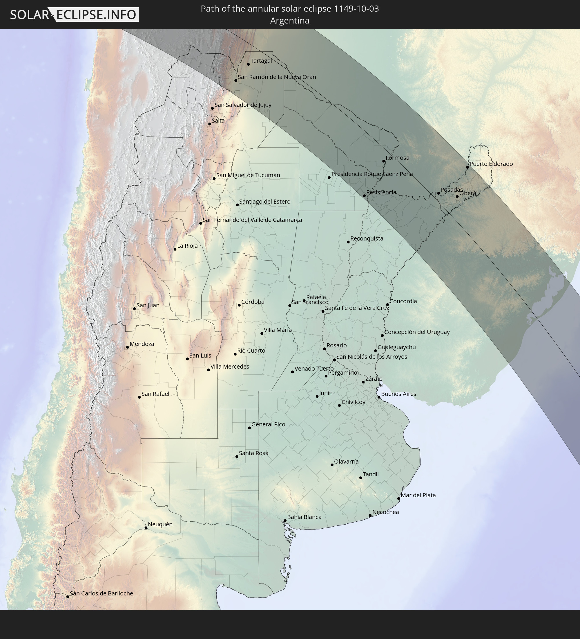 Argentina
 Bolivia
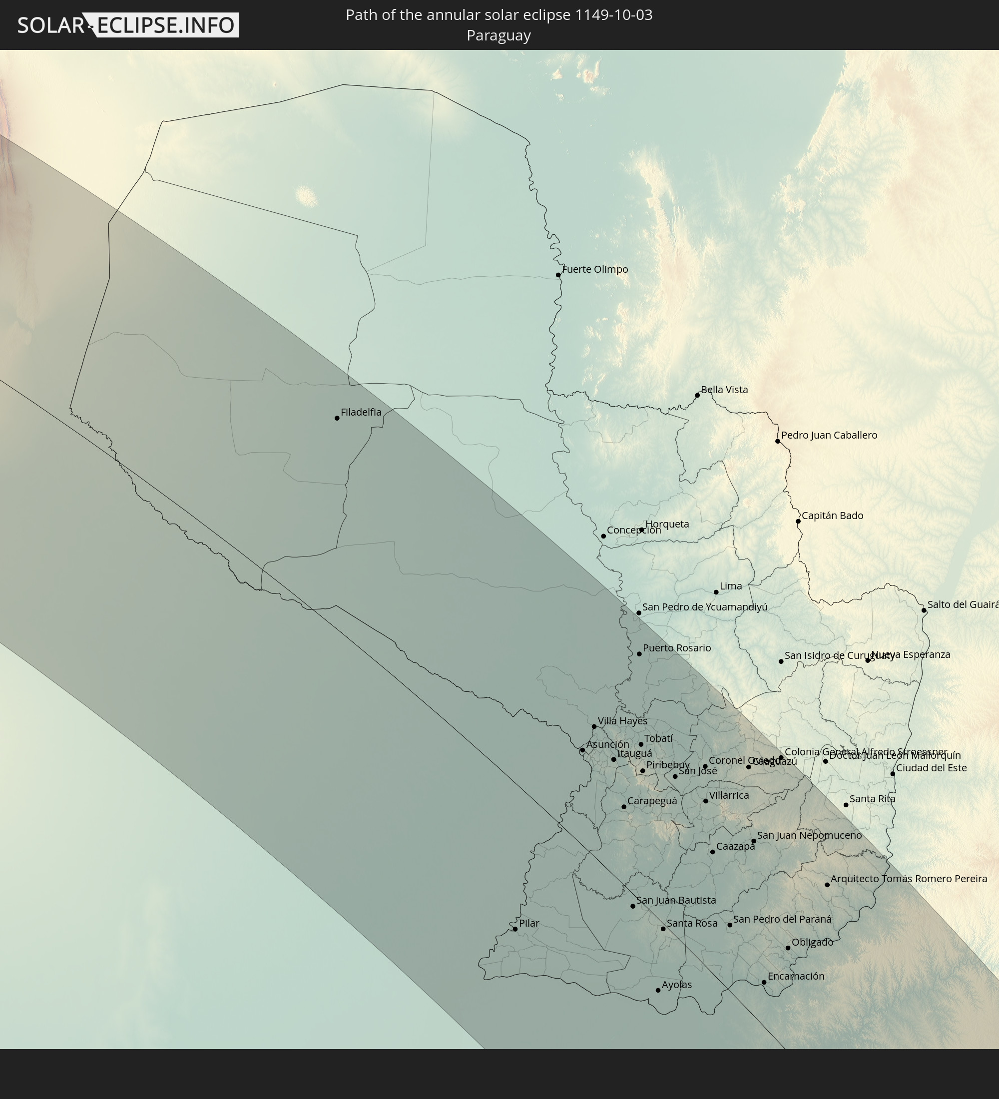 Paraguay
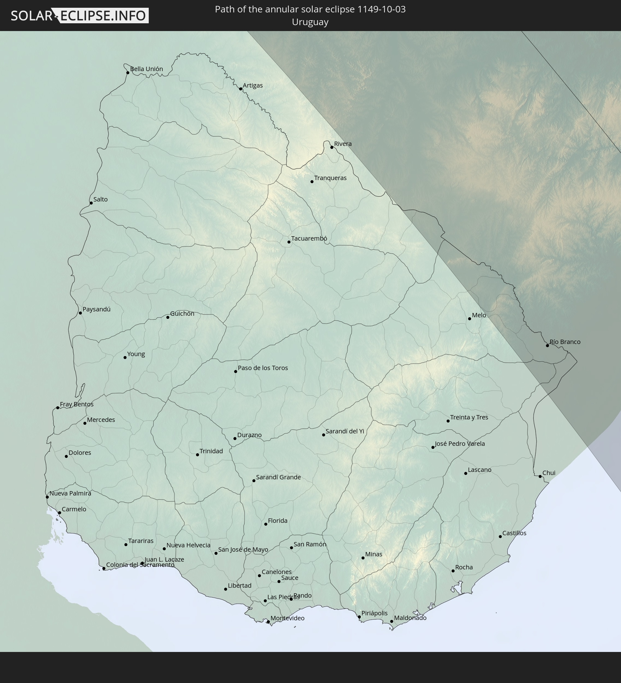 Uruguay
 South Georgia and the South Sandwich Islands
In den folgenden Ländern ist die Sonnenfinsternis partiell zu sehen
 Antarctica
 Chile
Chile
 Ecuador
 Panama
 Colombia
 Peru
Peru
 The Bahamas
 Haiti
Haiti
 Brazil
 Argentina
 Venezuela
 Turks and Caicos Islands
 Dominican Republic
 Aruba
Aruba
 Bolivia
 Puerto Rico
 United States Virgin Islands
 British Virgin Islands
 Anguilla
 Collectivity of Saint Martin
 Saint Barthélemy
 Saint Kitts and Nevis
 Paraguay
 Antigua and Barbuda
 Montserrat
 Trinidad and Tobago
 Guadeloupe
 Grenada
 Dominica
 Saint Vincent and the Grenadines
 Falkland Islands
 Guyana
 Martinique
 Saint Lucia
 Barbados
 Uruguay
 Suriname
 French Guiana
 South Georgia and the South Sandwich Islands
 Saint Helena, Ascension and Tristan da Cunha
 Bouvet Island
 French Southern and Antarctic Lands
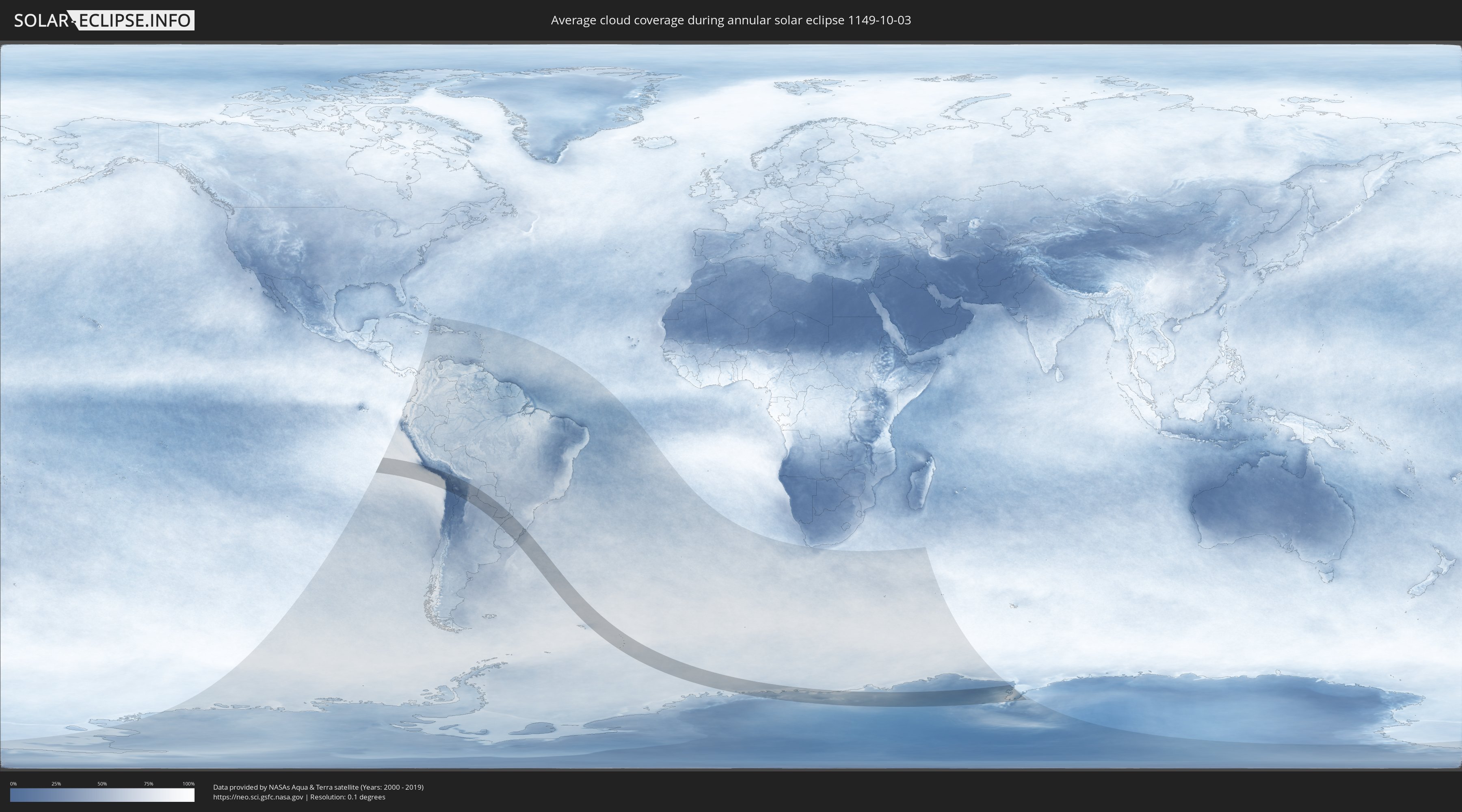
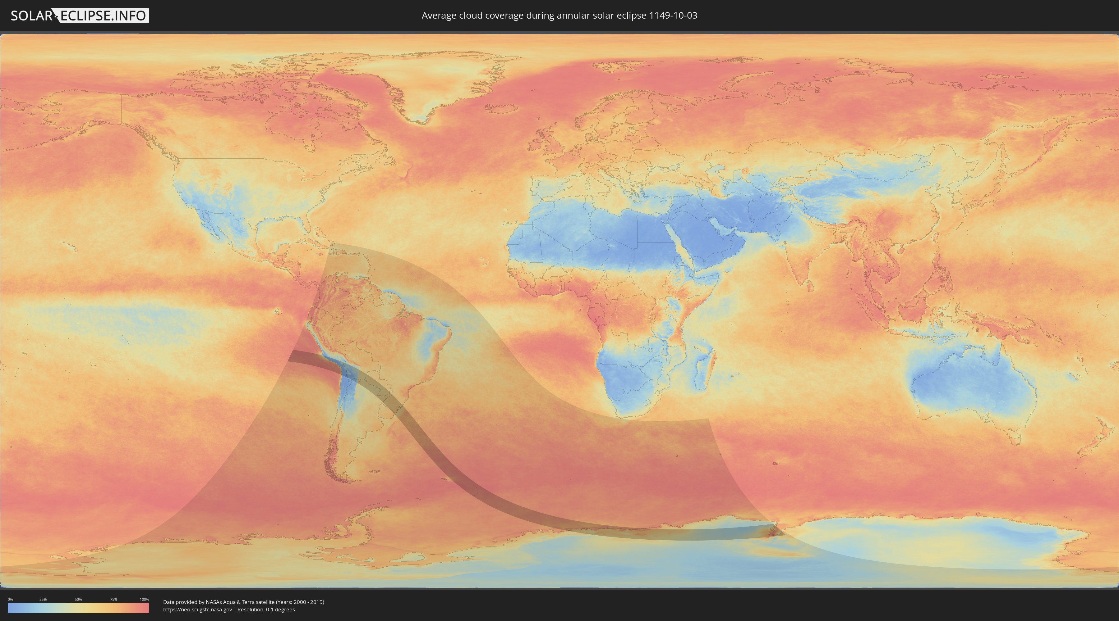
How will be the weather during the annular solar eclipse on 10/03/1149?
Where is the best place to see the annular solar eclipse of 10/03/1149?
The following maps show the average cloud coverage for the day of the annular solar eclipse.
With the help of these maps, it is possible to find the place along the eclipse path, which has the best
chance of a cloudless sky.
Nevertheless, you should consider local circumstances and inform about the weather of your chosen
observation site.
The data is provided by NASAs satellites
AQUA and TERRA.
The cloud maps are averaged over a period of 19 years (2000 - 2019).
Detailed country maps
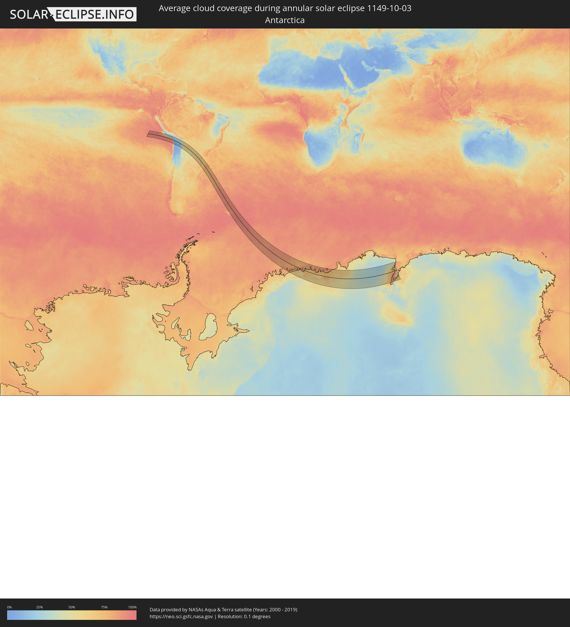 Antarctica
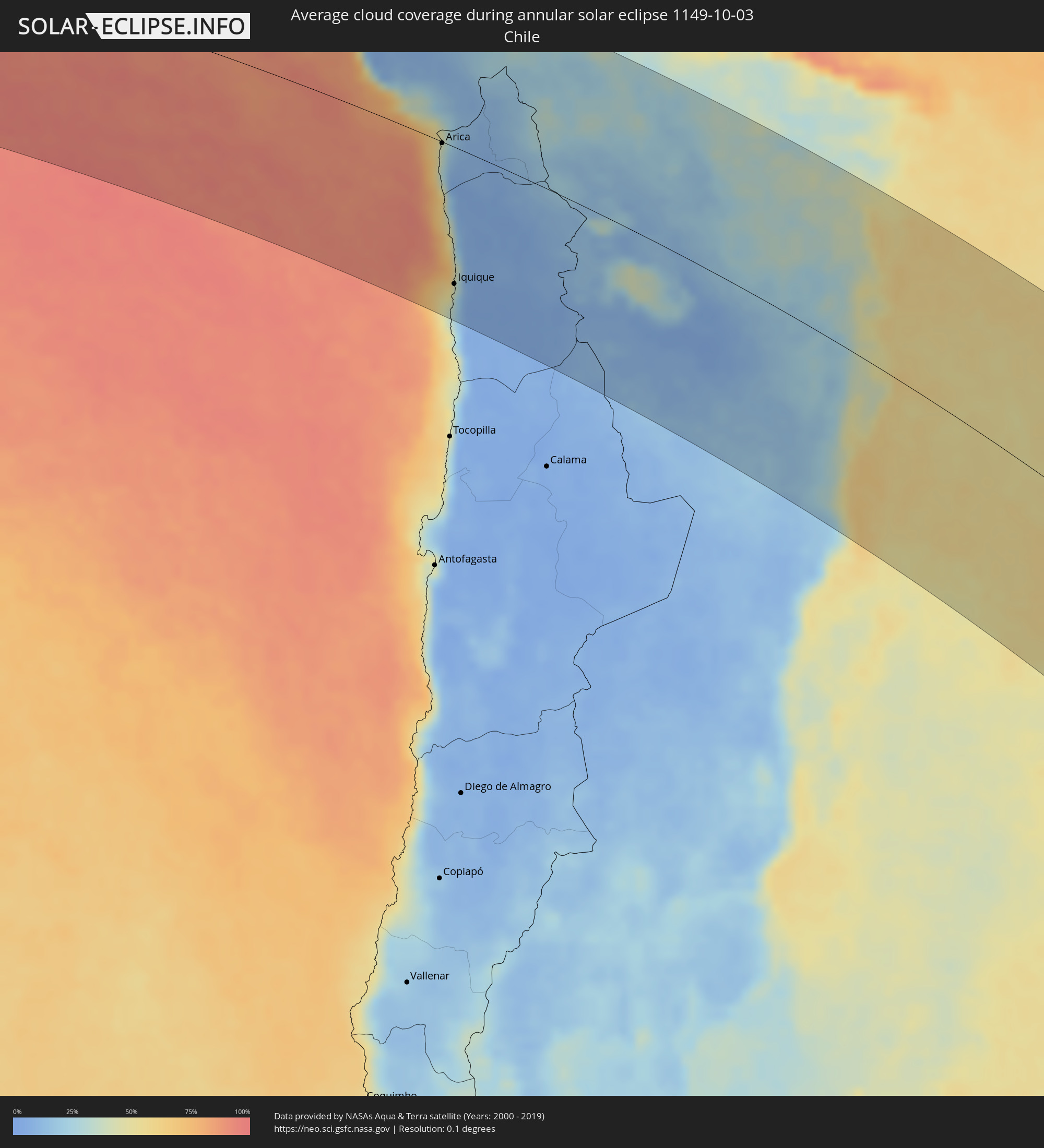 Chile
Chile
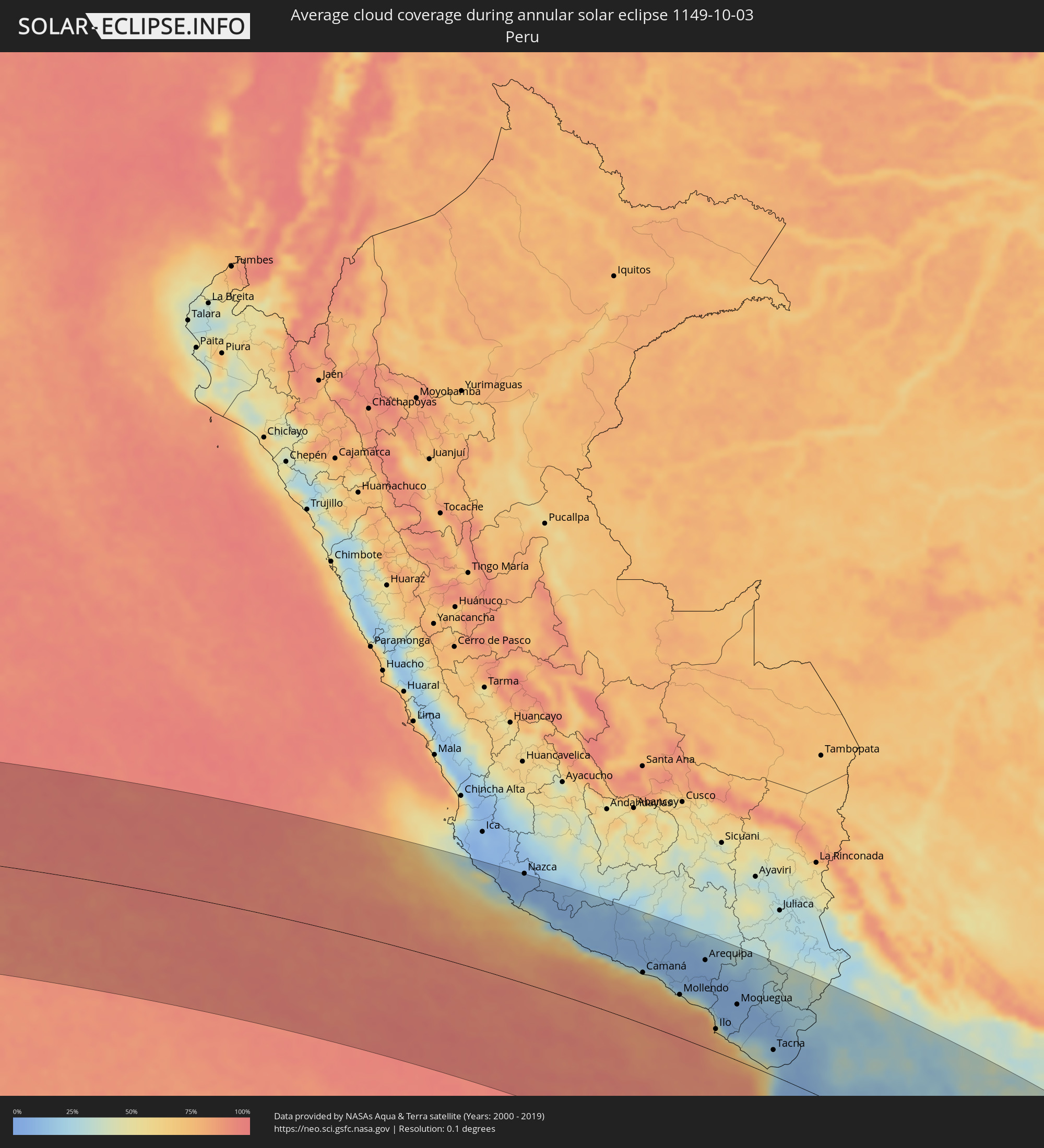 Peru
Peru
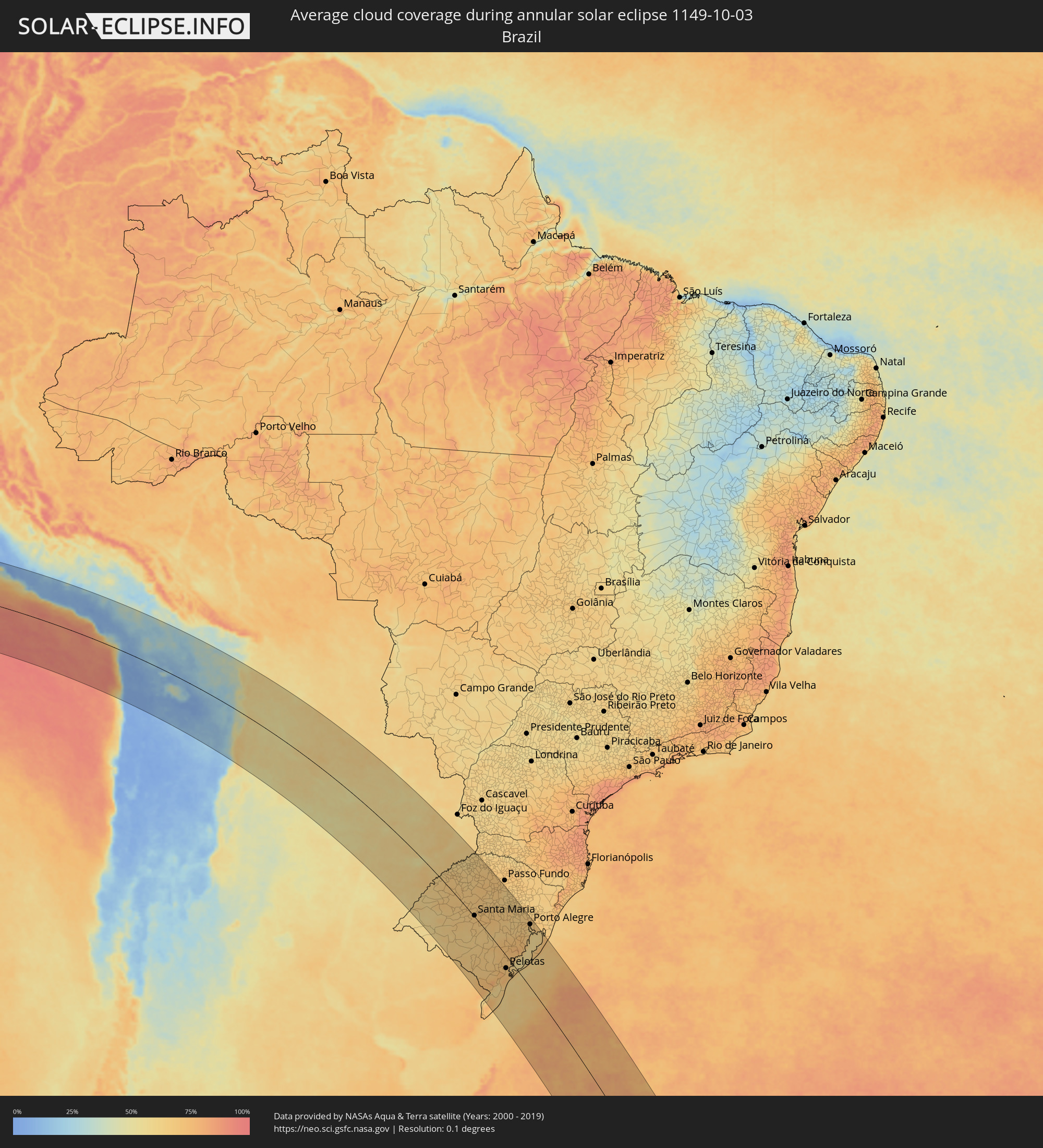 Brazil
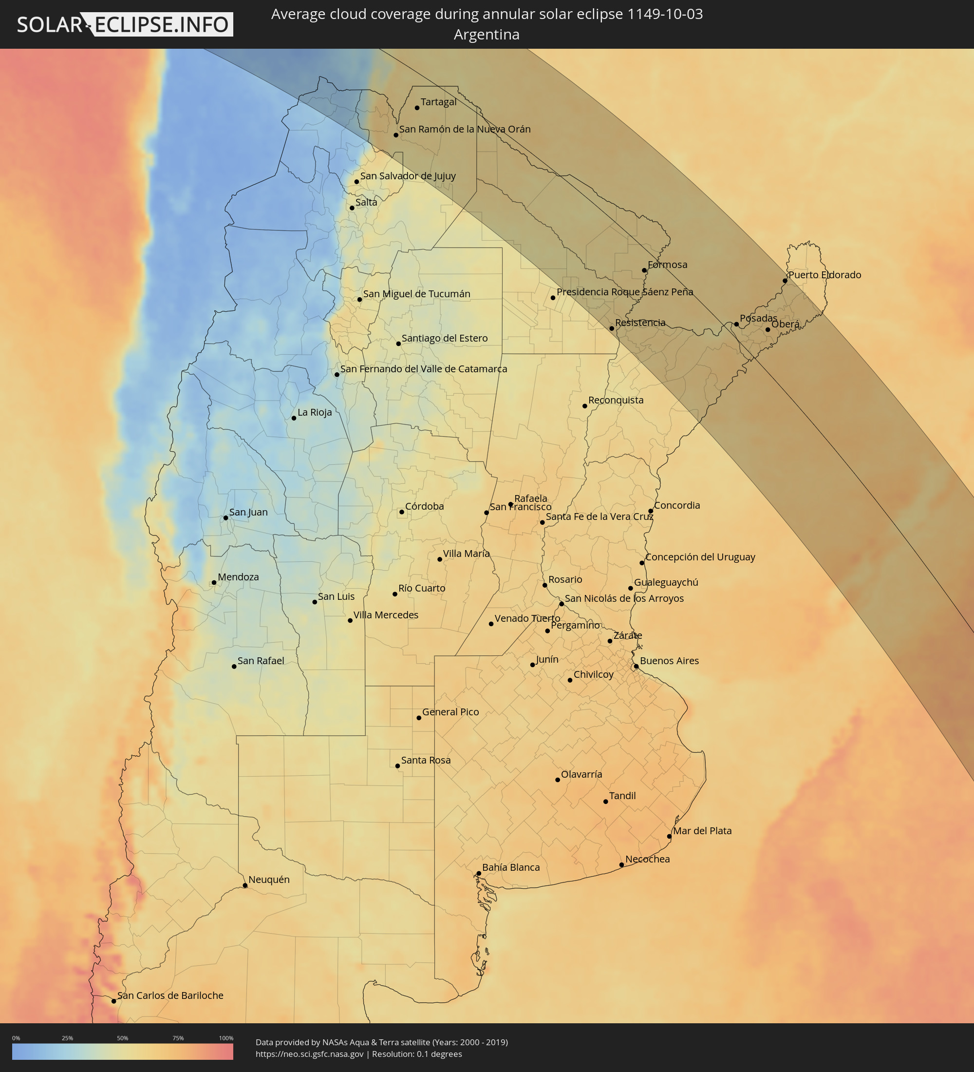 Argentina
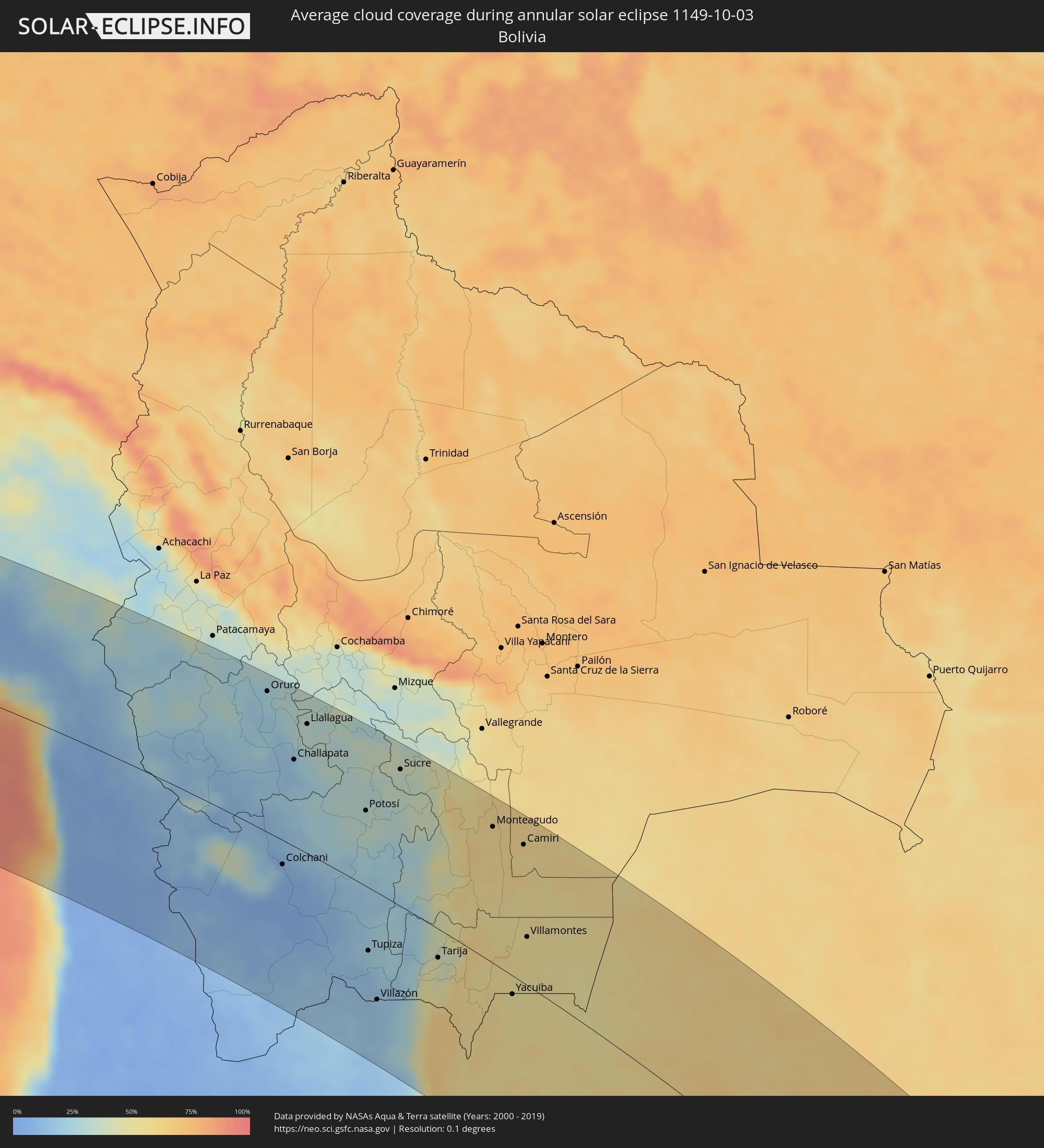 Bolivia
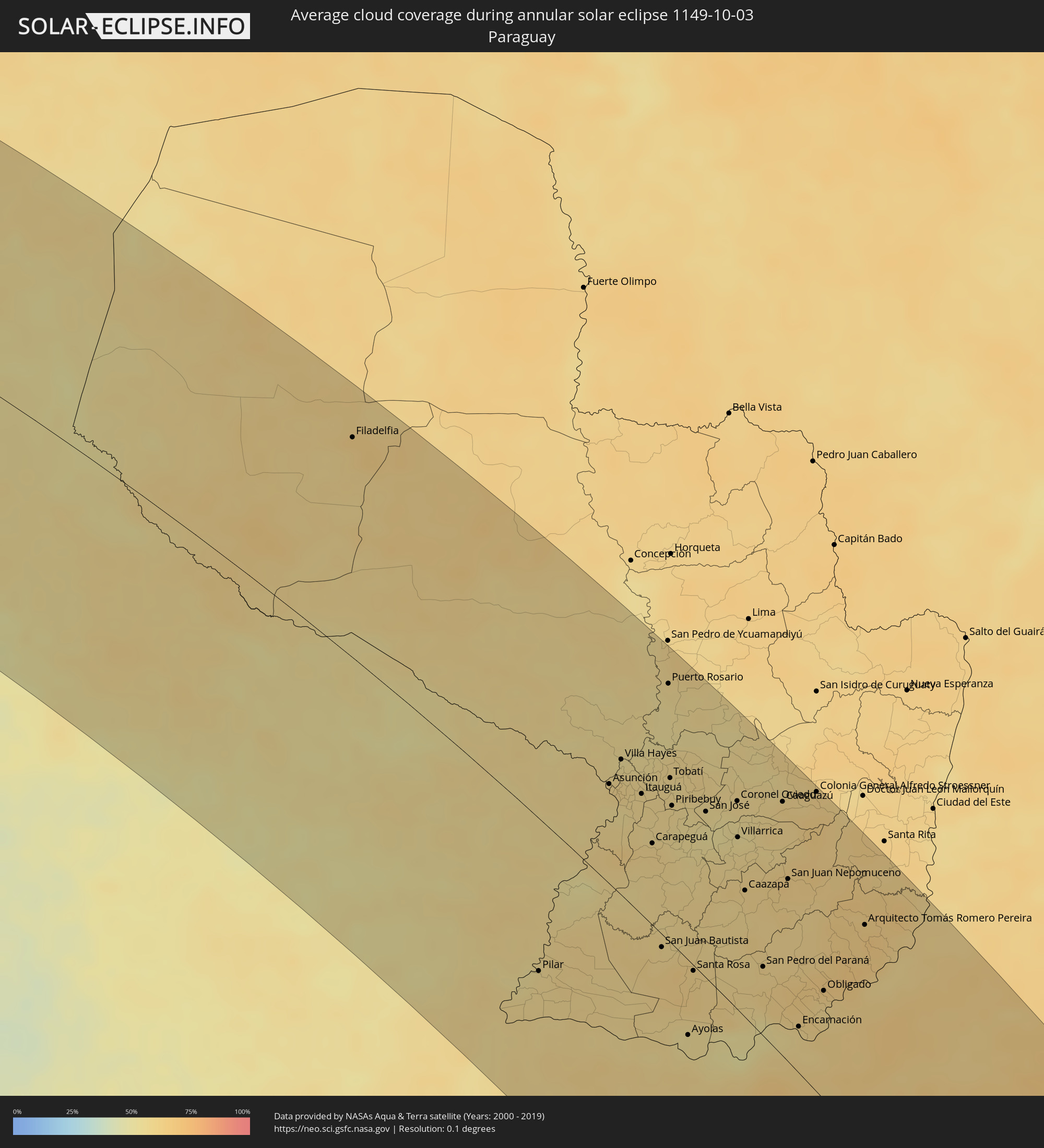 Paraguay
 Uruguay
 South Georgia and the South Sandwich Islands
Cities inside the path of the eclipse
The following table shows all locations with a population of more than 5,000 inside the eclipse path. Cities which have more than 100,000 inhabitants are marked bold. A click at the locations opens a detailed map.
| City | Type | Eclipse duration | Local time of max. eclipse | Distance to central line | Ø Cloud coverage |
|
Minas de Marcona, Ica
|
annular | - | 06:19:27 UTC-05:08 | 165 km | 15% |
|
Camaná, Arequipa
|
annular | - | 06:22:17 UTC-05:08 | 96 km | 67% |
|
Mollendo, Arequipa
|
annular | - | 06:23:09 UTC-05:08 | 80 km | 72% |
|
Lluta, Arequipa
|
annular | - | 06:21:26 UTC-05:08 | 185 km | 10% |
|
Punta de Bombón, Arequipa
|
annular | - | 06:23:28 UTC-05:08 | 73 km | 80% |
|
Cocachacra, Arequipa
|
annular | - | 06:23:20 UTC-05:08 | 83 km | 70% |
|
Yura, Arequipa
|
annular | - | 06:21:55 UTC-05:08 | 173 km | 7% |
|
Arequipa, Arequipa
|
annular | - | 06:22:13 UTC-05:08 | 163 km | 9% |
|
Ilo, Moquegua
|
annular | - | 06:24:25 UTC-05:08 | 42 km | 62% |
|
Pacocha, Moquegua
|
annular | - | 06:24:20 UTC-05:08 | 48 km | 62% |
|
Moquegua, Moquegua
|
annular | - | 06:23:47 UTC-05:08 | 104 km | 9% |
|
Torata, Moquegua
|
annular | - | 06:23:36 UTC-05:08 | 120 km | 7% |
|
Ilabaya, Tacna
|
annular | - | 06:24:18 UTC-05:08 | 97 km | 9% |
|
Arica, Arica y Parinacota
|
annular | - | 06:52:06 UTC-04:42 | 2 km | 35% |
|
Tacna, Tacna
|
annular | - | 06:25:27 UTC-05:08 | 47 km | 26% |
|
Iquique, Tarapacá
|
annular | - | 06:55:21 UTC-04:42 | 173 km | 31% |
|
Oruro, Oruro
|
annular | - | 07:02:38 UTC-04:32 | 187 km | 25% |
|
Colchani, Potosí
|
annular | - | 07:07:06 UTC-04:32 | 32 km | 9% |
|
Huanuni, Oruro
|
annular | - | 07:03:20 UTC-04:32 | 172 km | 29% |
|
Uyuni, Potosí
|
annular | - | 07:07:27 UTC-04:32 | 42 km | 6% |
|
Challapata, Oruro
|
annular | - | 07:04:31 UTC-04:32 | 114 km | 20% |
|
Llallagua, Potosí
|
annular | - | 07:03:42 UTC-04:32 | 170 km | 33% |
|
Potosí, Potosí
|
annular | - | 07:06:19 UTC-04:32 | 98 km | 32% |
|
Tupiza, Potosí
|
annular | - | 07:09:57 UTC-04:32 | 80 km | 22% |
|
Villazón, Potosí
|
annular | - | 07:11:18 UTC-04:32 | 135 km | 17% |
|
La Quiaca, Jujuy Province
|
annular | - | 07:27:08 UTC-04:16 | 137 km | 17% |
|
Sucre, Chuquisaca
|
annular | - | 07:05:31 UTC-04:32 | 176 km | 37% |
|
Tarija, Tarija
|
annular | - | 07:10:42 UTC-04:32 | 36 km | 42% |
|
San Ramón de la Nueva Orán, Salta Province
|
annular | - | 07:29:58 UTC-04:16 | 163 km | 55% |
|
Embarcación, Salta Province
|
annular | - | 07:30:16 UTC-04:16 | 157 km | 55% |
|
Monteagudo, Chuquisaca
|
annular | - | 07:07:43 UTC-04:32 | 171 km | 57% |
|
Tartagal, Salta Province
|
annular | - | 07:29:02 UTC-04:16 | 76 km | 56% |
|
Yacuiba, Tarija
|
annular | - | 07:12:18 UTC-04:32 | 23 km | 52% |
|
Camiri, Santa Cruz
|
annular | - | 07:08:26 UTC-04:32 | 172 km | 57% |
|
Villamontes, Tarija
|
annular | - | 07:10:54 UTC-04:32 | 59 km | 52% |
|
Ingeniero Guillermo N. Juárez, Formosa Province
|
annular | - | 07:33:12 UTC-04:16 | 86 km | 57% |
|
Castelli, Chaco Province
|
annular | - | 07:38:30 UTC-04:16 | 185 km | 51% |
|
Las Lomitas, Formosa Province
|
annular | - | 07:35:51 UTC-04:16 | 77 km | 52% |
|
Tres Isletas, Chaco Province
|
annular | - | 07:39:30 UTC-04:16 | 205 km | 51% |
|
Filadelfia, Boquerón
|
annular | - | 07:57:23 UTC-03:50 | 165 km | 63% |
|
Pampa del Indio, Chaco Province
|
annular | - | 07:39:18 UTC-04:16 | 148 km | 52% |
|
El Colorado, Formosa Province
|
annular | - | 07:40:17 UTC-04:16 | 132 km | 54% |
|
General José de San Martín, Chaco Province
|
annular | - | 07:40:49 UTC-04:16 | 149 km | 54% |
|
Pirané, Formosa Province
|
annular | - | 07:39:14 UTC-04:16 | 67 km | 55% |
|
Resistencia, Chaco Province
|
annular | - | 07:43:09 UTC-04:16 | 199 km | 56% |
|
San Luis del Palmar, Corrientes Province
|
annular | - | 07:43:37 UTC-04:16 | 173 km | 57% |
|
Pilar, Ñeembucú
|
annular | - | 08:08:33 UTC-03:50 | 104 km | 58% |
|
Formosa, Formosa Province
|
annular | - | 07:41:00 UTC-04:16 | 40 km | 57% |
|
Clorinda, Formosa Province
|
annular | - | 07:39:25 UTC-04:16 | 64 km | 58% |
|
Asunción, Asunción
|
annular | - | 08:05:40 UTC-03:50 | 68 km | 60% |
|
Benjamín Aceval, Presidente Hayes
|
annular | - | 08:04:59 UTC-03:50 | 101 km | 55% |
|
Limpio, Central
|
annular | - | 08:05:29 UTC-03:50 | 90 km | 59% |
|
Guarambaré, Central
|
annular | - | 08:06:12 UTC-03:50 | 65 km | 55% |
|
Capiatá, Central
|
annular | - | 08:05:57 UTC-03:50 | 77 km | 57% |
|
Areguá, Central
|
annular | - | 08:05:54 UTC-03:50 | 84 km | 57% |
|
Itá, Central
|
annular | - | 08:06:20 UTC-03:50 | 70 km | 56% |
|
Emboscada, Cordillera
|
annular | - | 08:05:34 UTC-03:50 | 100 km | 58% |
|
Yaguarón, Paraguarí
|
annular | - | 08:06:36 UTC-03:50 | 67 km | 57% |
|
Ypacarai, Central
|
annular | - | 08:06:12 UTC-03:50 | 83 km | 57% |
|
Paraguarí, Paraguarí
|
annular | - | 08:06:47 UTC-03:50 | 76 km | 57% |
|
San Juan Bautista, Misiones
|
annular | - | 08:09:07 UTC-03:50 | 9 km | 61% |
|
Caacupé, Cordillera
|
annular | - | 08:06:16 UTC-03:50 | 95 km | 58% |
|
Tobatí, Cordillera
|
annular | - | 08:06:02 UTC-03:50 | 111 km | 58% |
|
Piribebuy, Cordillera
|
annular | - | 08:06:34 UTC-03:50 | 93 km | 58% |
|
Eusebio Ayala, Cordillera
|
annular | - | 08:06:27 UTC-03:50 | 106 km | 57% |
|
Ayolas, Misiones
|
annular | - | 08:10:58 UTC-03:50 | 49 km | 55% |
|
Santa Rosa, Misiones
|
annular | - | 08:09:49 UTC-03:50 | 4 km | 62% |
|
Itaqui, Rio Grande do Sul
|
annular | - | 08:59:23 UTC-03:06 | 156 km | 61% |
|
Coronel Oviedo, Caaguazú
|
annular | - | 08:07:01 UTC-03:50 | 138 km | 57% |
|
Villarrica, Guairá
|
annular | - | 08:07:42 UTC-03:50 | 114 km | 56% |
|
Caazapá, Caazapá
|
annular | - | 08:08:46 UTC-03:50 | 83 km | 58% |
|
Santo Tomé, Corrientes Province
|
annular | - | 07:48:14 UTC-04:16 | 76 km | 62% |
|
Gobernador Ingeniero Valentín Virasoro, Corrientes Province
|
annular | - | 07:47:06 UTC-04:16 | 38 km | 67% |
|
Caaguazú, Caaguazú
|
annular | - | 08:07:25 UTC-03:50 | 167 km | 59% |
|
São Borja, Rio Grande do Sul
|
annular | - | 08:58:51 UTC-03:06 | 82 km | 62% |
|
San Juan Nepomuceno, Caazapá
|
annular | - | 08:08:55 UTC-03:50 | 119 km | 62% |
|
Repatriación, Caaguazú
|
annular | - | 08:07:39 UTC-03:50 | 165 km | 59% |
|
Posadas, Misiones Province
|
annular | - | 07:45:41 UTC-04:16 | 25 km | 59% |
|
Encarnación, Itapúa
|
annular | - | 08:11:46 UTC-03:50 | 30 km | 56% |
|
Alegrete, Rio Grande do Sul
|
annular | - | 09:01:36 UTC-03:06 | 149 km | 59% |
|
Candelaria, Misiones Province
|
annular | - | 07:46:02 UTC-04:16 | 28 km | 60% |
|
Colonia General Alfredo Stroessner, Caaguazú
|
annular | - | 08:07:31 UTC-03:50 | 196 km | 62% |
|
Obligado, Itapúa
|
annular | - | 08:11:19 UTC-03:50 | 69 km | 60% |
|
Jardín América, Misiones Province
|
annular | - | 07:45:35 UTC-04:16 | 97 km | 61% |
|
Oberá, Misiones Province
|
annular | - | 07:46:42 UTC-04:16 | 71 km | 64% |
|
Puerto Rico, Misiones Province
|
annular | - | 07:45:13 UTC-04:16 | 131 km | 57% |
|
São Luiz Gonzaga, Rio Grande do Sul
|
annular | - | 08:59:17 UTC-03:06 | 13 km | 68% |
|
Rosário do Sul, Rio Grande do Sul
|
annular | - | 09:03:33 UTC-03:06 | 119 km | 65% |
|
Aristóbulo del Valle, Misiones Province
|
annular | - | 07:46:01 UTC-04:16 | 117 km | 64% |
|
Santiago, Rio Grande do Sul
|
annular | - | 09:01:10 UTC-03:06 | 39 km | 69% |
|
Montecarlo, Misiones Province
|
annular | - | 07:44:57 UTC-04:16 | 168 km | 58% |
|
Veinticinco de Mayo, Misiones Province
|
annular | - | 07:46:48 UTC-04:16 | 106 km | 62% |
|
Puerto Eldorado, Misiones Province
|
annular | - | 08:10:47 UTC-03:50 | 184 km | 60% |
|
Dos de Mayo, Misiones Province
|
annular | - | 07:46:03 UTC-04:16 | 138 km | 63% |
|
Dom Pedrito, Rio Grande do Sul
|
annular | - | 09:05:28 UTC-03:06 | 153 km | 65% |
|
Santa Rosa, Rio Grande do Sul
|
annular | - | 08:58:31 UTC-03:06 | 88 km | 64% |
|
São Gabriel, Rio Grande do Sul
|
annular | - | 09:04:20 UTC-03:06 | 81 km | 64% |
|
Santo Ângelo, Rio Grande do Sul
|
annular | - | 08:59:43 UTC-03:06 | 71 km | 64% |
|
El Soberbio, Misiones Province
|
annular | - | 07:47:09 UTC-04:16 | 152 km | 60% |
|
Bagé, Rio Grande do Sul
|
annular | - | 09:06:51 UTC-03:06 | 135 km | 65% |
|
Ijuí, Rio Grande do Sul
|
annular | - | 09:00:16 UTC-03:06 | 90 km | 64% |
|
Santa Maria, Rio Grande do Sul
|
annular | - | 09:03:21 UTC-03:06 | 4 km | 69% |
|
Cruz Alta, Rio Grande do Sul
|
annular | - | 09:01:09 UTC-03:06 | 94 km | 70% |
|
Panambi, Rio Grande do Sul
|
annular | - | 09:00:28 UTC-03:06 | 127 km | 67% |
|
Río Branco, Cerro Largo
|
annular | - | 08:32:09 UTC-03:44 | 167 km | 75% |
|
Palmeira das Missões, Rio Grande do Sul
|
annular | - | 08:59:45 UTC-03:06 | 170 km | 68% |
|
Cachoeira do Sul, Rio Grande do Sul
|
annular | - | 09:05:07 UTC-03:06 | 46 km | 69% |
|
Carazinho, Rio Grande do Sul
|
annular | - | 09:01:10 UTC-03:06 | 181 km | 69% |
|
Santa Cruz do Sul, Rio Grande do Sul
|
annular | - | 09:04:52 UTC-03:06 | 103 km | 69% |
|
Pelotas, Rio Grande do Sul
|
annular | - | 09:09:44 UTC-03:06 | 33 km | 69% |
|
Venâncio Aires, Rio Grande do Sul
|
annular | - | 09:04:51 UTC-03:06 | 129 km | 66% |
|
Rio Grande, Rio Grande do Sul
|
annular | - | 09:10:36 UTC-03:06 | 33 km | 69% |
|
Lajeado, Rio Grande do Sul
|
annular | - | 09:04:46 UTC-03:06 | 156 km | 65% |
|
Camaquã, Rio Grande do Sul
|
annular | - | 09:08:09 UTC-03:06 | 70 km | 77% |
|
Charqueadas, Rio Grande do Sul
|
annular | - | 09:06:16 UTC-03:06 | 146 km | 68% |
|
Montenegro, Rio Grande do Sul
|
annular | - | 09:05:50 UTC-03:06 | 177 km | 66% |
|
Porto Alegre, Rio Grande do Sul
|
annular | - | 09:06:53 UTC-03:06 | 170 km | 67% |
|
Cachoeirinha, Rio Grande do Sul
|
annular | - | 09:06:50 UTC-03:06 | 186 km | 69% |
|
Viamão, Rio Grande do Sul
|
annular | - | 09:07:13 UTC-03:06 | 182 km | 70% |