Total solar eclipse of 03/31/1177
| Day of week: | Thursday |
| Maximum duration of eclipse: | 02m33s |
| Maximum width of eclipse path: | 86 km |
| Saros cycle: | 106 |
| Coverage: | 100% |
| Magnitude: | 1.0253 |
| Gamma: | -0.0073 |
Wo kann man die Sonnenfinsternis vom 03/31/1177 sehen?
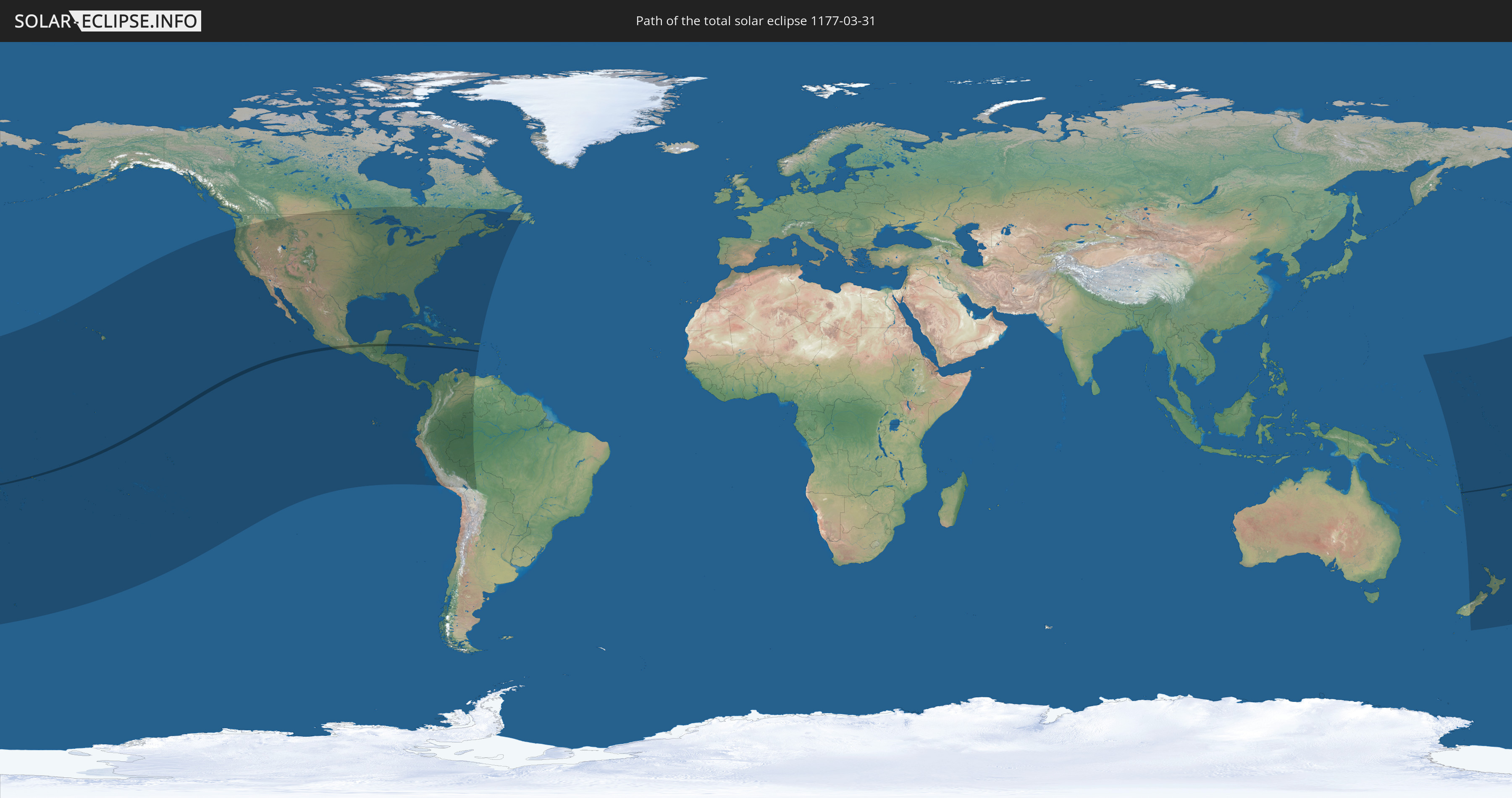
Die Sonnenfinsternis am 03/31/1177 kann man in 47 Ländern als partielle Sonnenfinsternis beobachten.
Der Finsternispfad verläuft durch 7 Länder. Nur in diesen Ländern ist sie als total Sonnenfinsternis zu sehen.
In den folgenden Ländern ist die Sonnenfinsternis total zu sehen
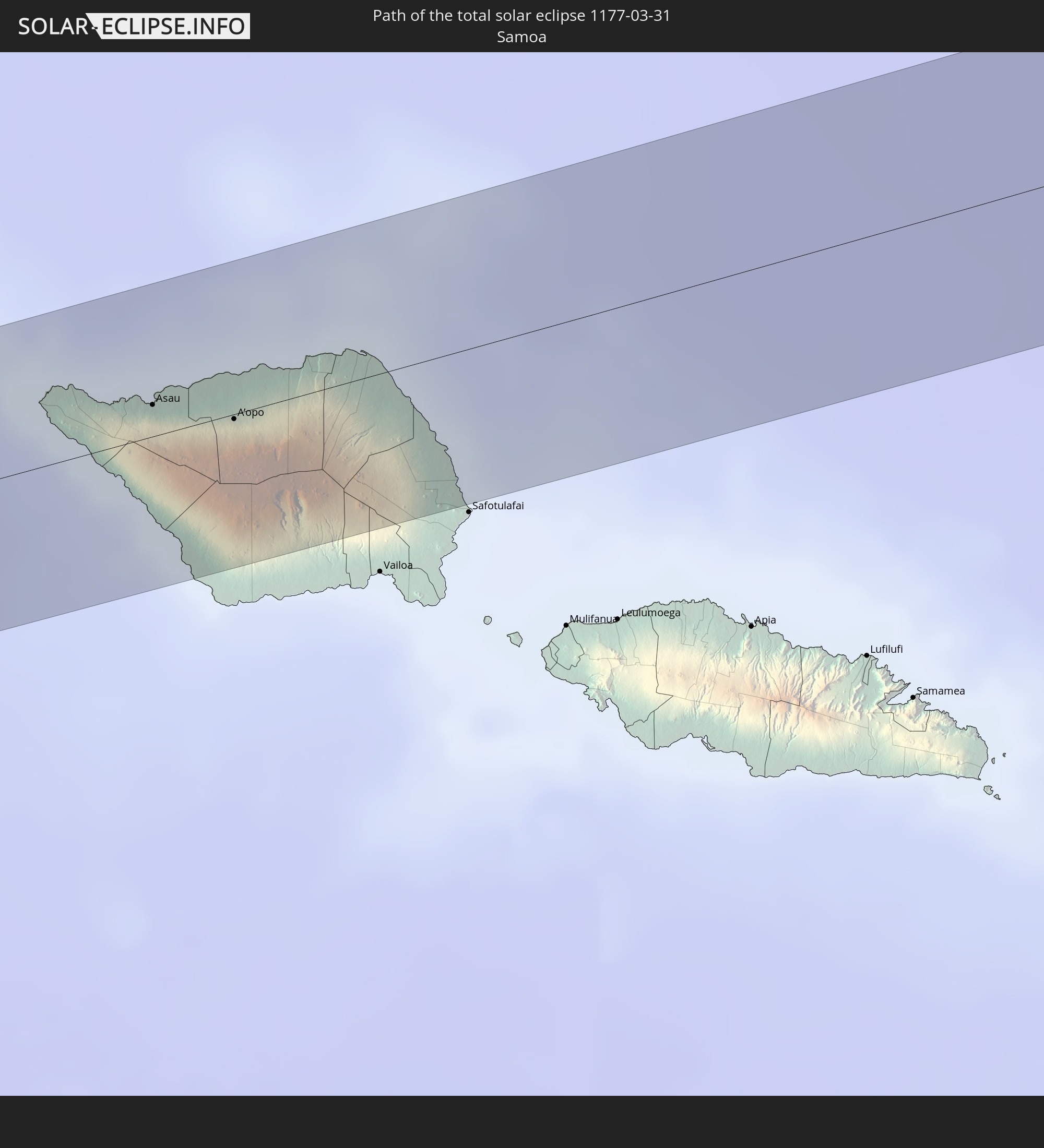 Samoa
Samoa
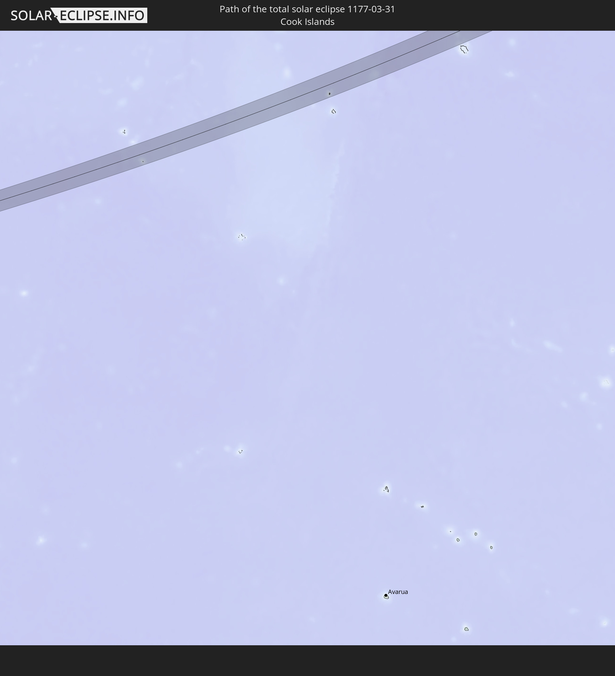 Cook Islands
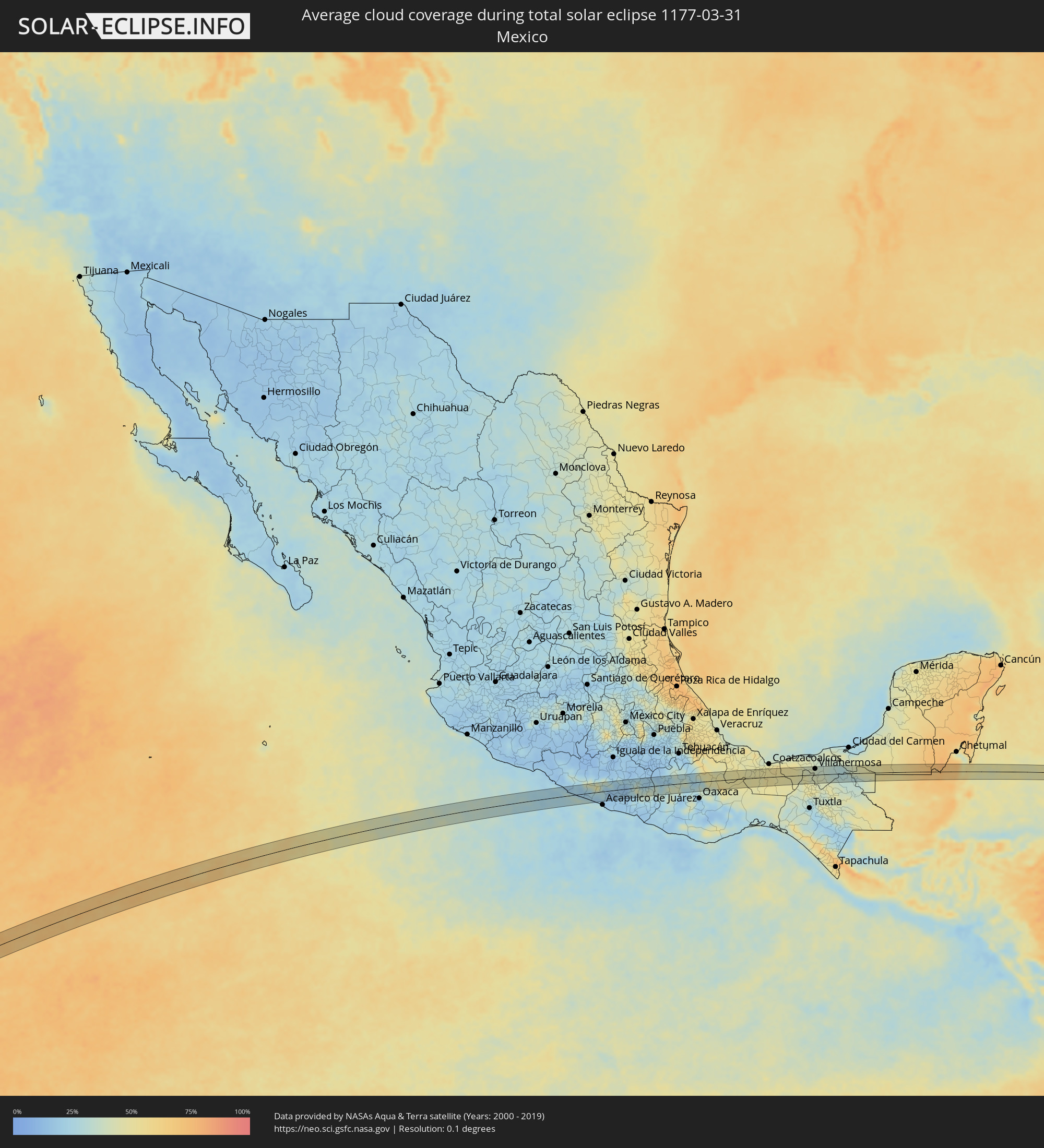
 Mexico
 Guatemala
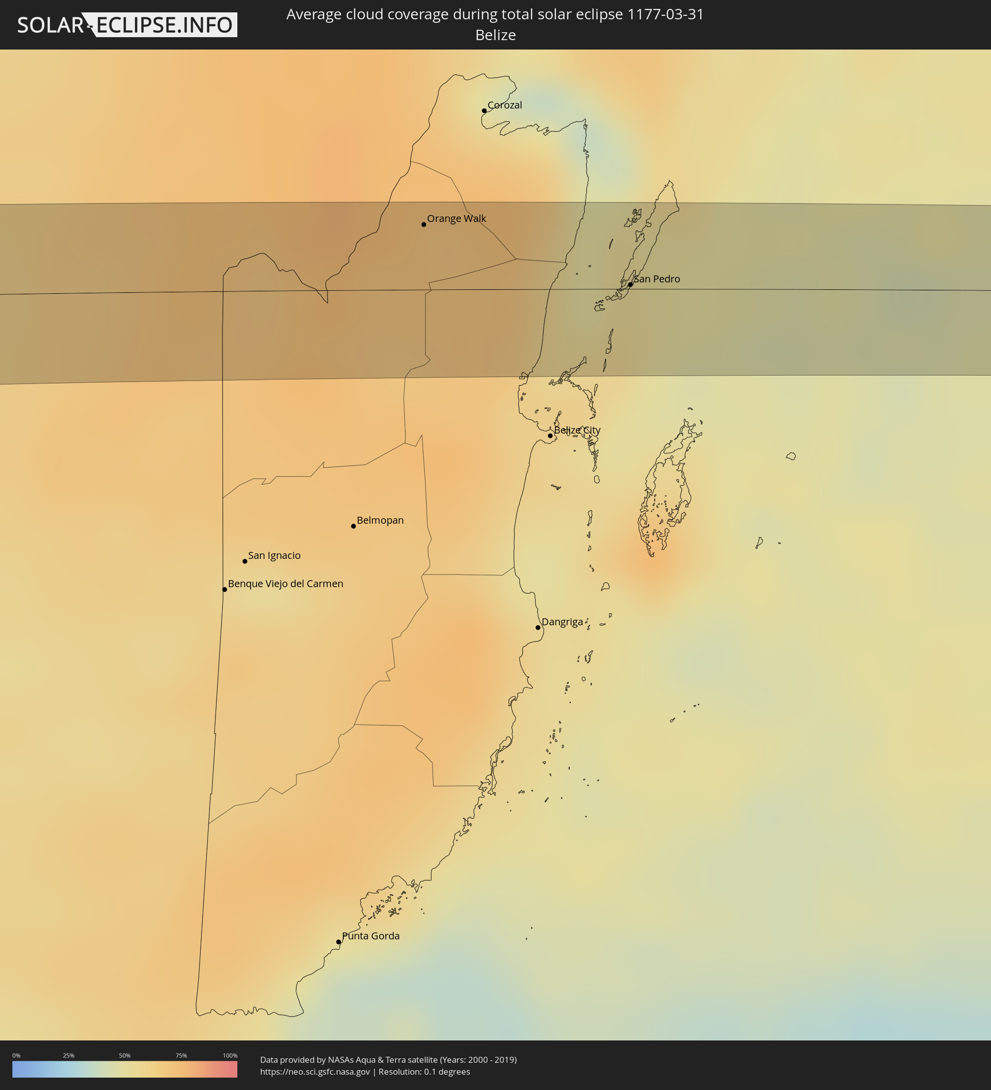
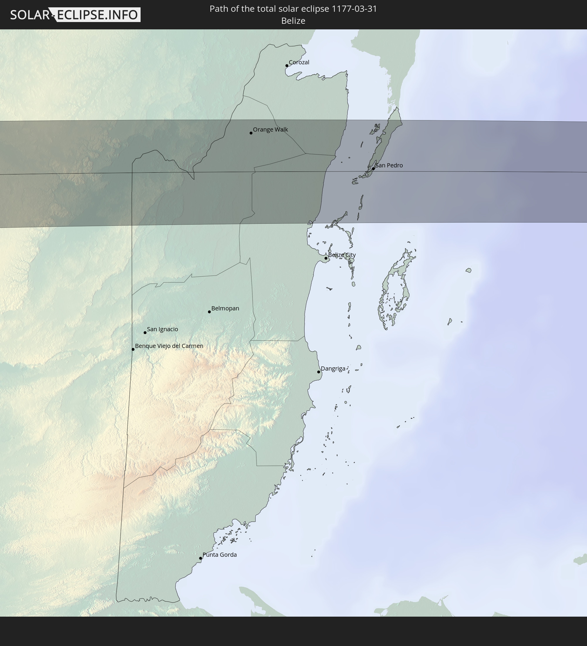 Belize
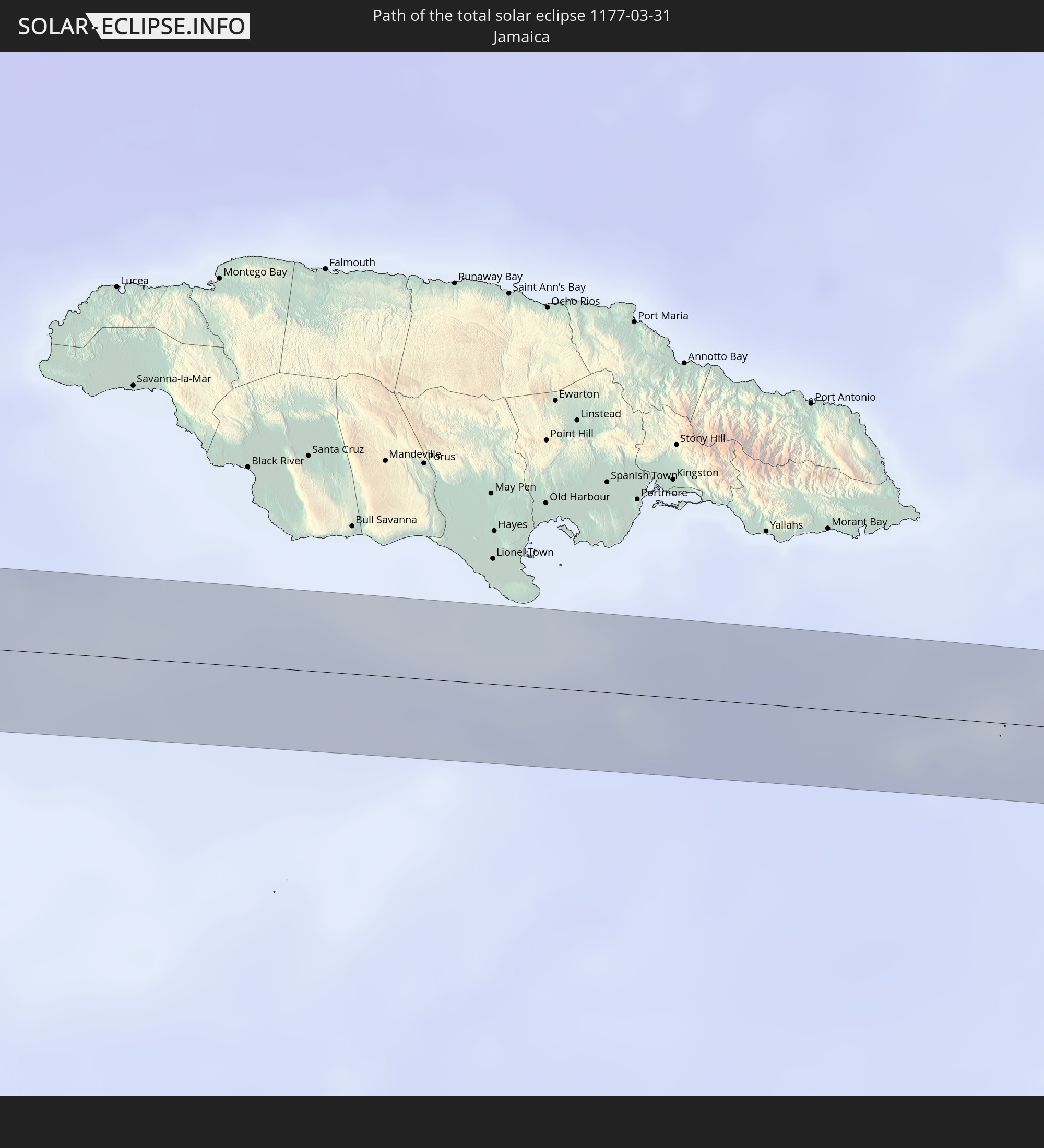 Jamaica
 Vanuatu
In den folgenden Ländern ist die Sonnenfinsternis partiell zu sehen
 Fiji
Fiji
 United States
 New Zealand
 United States Minor Outlying Islands
 Wallis and Futuna
 Tonga
Tonga
 Kiribati
 Samoa
Samoa
 Tokelau
 American Samoa
 Niue
Niue
 Cook Islands
 French Polynesia
 Canada
 Pitcairn Islands
 Mexico
 Guatemala
 Ecuador
 El Salvador
 Honduras
 Belize
 Nicaragua
 Costa Rica
 Cuba
Cuba
 Panama
 Colombia
 Cayman Islands
 Peru
Peru
 The Bahamas
 Jamaica
 Haiti
Haiti
 Brazil
 Venezuela
 Turks and Caicos Islands
 Dominican Republic
 Aruba
Aruba
 Bolivia
 Puerto Rico
 Bermuda
 Saint Pierre and Miquelon
 Federated States of Micronesia
 Solomon Islands
 New Caledonia
 Marshall Islands
 Vanuatu
 Nauru
Nauru
 Tuvalu
How will be the weather during the total solar eclipse on 03/31/1177?
Where is the best place to see the total solar eclipse of 03/31/1177?
The following maps show the average cloud coverage for the day of the total solar eclipse.
With the help of these maps, it is possible to find the place along the eclipse path, which has the best
chance of a cloudless sky.
Nevertheless, you should consider local circumstances and inform about the weather of your chosen
observation site.
The data is provided by NASAs satellites
AQUA and TERRA.
The cloud maps are averaged over a period of 19 years (2000 - 2019).


Detailed country maps
 Samoa
Samoa
 Cook Islands
 Mexico
 Guatemala
 Belize
 Jamaica
 Vanuatu
Cities inside the path of the eclipse
The following table shows all locations with a population of more than 5,000 inside the eclipse path. Cities which have more than 100,000 inhabitants are marked bold. A click at the locations opens a detailed map.
| City | Type | Eclipse duration | Local time of max. eclipse | Distance to central line | Ø Cloud coverage |
|
Asau, Vaisigano
|
total | - | 07:39:38 UTC-11:26 | 5 km | 79% |
|
A’opo, Gagaifomauga
|
total | - | 07:39:43 UTC-11:26 | 1 km | 78% |
|
El Súchil, Guerrero
|
total | - | 15:34:20 UTC-06:36 | 4 km | 23% |
|
Técpan de Galeana, Guerrero
|
total | - | 15:34:21 UTC-06:36 | 3 km | 23% |
|
San Jerónimo de Juárez, Guerrero
|
total | - | 15:34:34 UTC-06:36 | 8 km | 31% |
|
Atoyac de Álvarez, Guerrero
|
total | - | 15:34:39 UTC-06:36 | 1 km | 21% |
|
Coyuca de Benítez, Guerrero
|
total | - | 15:35:07 UTC-06:36 | 27 km | 27% |
|
Kilómetro 30, Guerrero
|
total | - | 15:35:34 UTC-06:36 | 32 km | 16% |
|
Xaltianguis, Guerrero
|
total | - | 15:35:41 UTC-06:36 | 22 km | 17% |
|
Tierra Colorada, Guerrero
|
total | - | 15:35:59 UTC-06:36 | 17 km | 17% |
|
El Ocotito, Guerrero
|
total | - | 15:36:01 UTC-06:36 | 8 km | 17% |
|
Chilpancingo, Guerrero
|
total | - | 15:36:07 UTC-06:36 | 25 km | 20% |
|
Petaquillas, Guerrero
|
total | - | 15:36:10 UTC-06:36 | 18 km | 21% |
|
Tixtla de Guerrero, Guerrero
|
total | - | 15:36:17 UTC-06:36 | 26 km | 20% |
|
Quechultenango, Guerrero
|
total | - | 15:36:28 UTC-06:36 | 7 km | 14% |
|
Chilapa de Alvarez, Guerrero
|
total | - | 15:36:36 UTC-06:36 | 26 km | 17% |
|
Malinaltepec, Guerrero
|
total | - | 15:37:15 UTC-06:36 | 18 km | 36% |
|
Tlapa de Comonfort, Guerrero
|
total | - | 15:37:27 UTC-06:36 | 14 km | 27% |
|
Santiago Juxtlahuaca, Oaxaca
|
total | - | 15:38:11 UTC-06:36 | 15 km | 31% |
|
Heroica Ciudad de Tlaxiaco, Oaxaca
|
total | - | 15:38:37 UTC-06:36 | 25 km | 35% |
|
Heroica Ciudad de Tlaxiaco, Oaxaca
|
total | - | 15:38:38 UTC-06:36 | 25 km | 35% |
|
Tamazulapam Villa del Progreso, Oaxaca
|
total | - | 15:38:51 UTC-06:36 | 19 km | 28% |
|
Asunción Nochixtlán, Oaxaca
|
total | - | 15:39:17 UTC-06:36 | 9 km | 29% |
|
San Francisco Telixtlahuaca, Oaxaca
|
total | - | 15:39:40 UTC-06:36 | 30 km | 25% |
|
Valle Nacional, Oaxaca
|
total | - | 15:40:32 UTC-06:36 | 18 km | 46% |
|
Playa Vicente, Veracruz
|
total | - | 15:41:10 UTC-06:36 | 21 km | 48% |
|
Sayula de Alemán, Veracruz
|
total | - | 15:42:13 UTC-06:36 | 20 km | 48% |
|
Acayucan, Veracruz
|
total | - | 15:42:17 UTC-06:36 | 28 km | 48% |
|
Oluta, Veracruz
|
total | - | 15:42:18 UTC-06:36 | 25 km | 48% |
|
Soconusco, Veracruz
|
total | - | 15:42:19 UTC-06:36 | 29 km | 48% |
|
Texistepec, Veracruz
|
total | - | 15:42:23 UTC-06:36 | 21 km | 49% |
|
Coacotla, Veracruz
|
total | - | 15:42:35 UTC-06:36 | 24 km | 48% |
|
Cuichapa, Veracruz
|
total | - | 15:43:02 UTC-06:36 | 22 km | 50% |
|
Las Choapas, Veracruz
|
total | - | 15:43:14 UTC-06:36 | 18 km | 51% |
|
Chontalpa, Tabasco
|
total | - | 15:43:55 UTC-06:36 | 13 km | 44% |
|
Huimanguillo, Tabasco
|
total | - | 15:44:02 UTC-06:36 | 6 km | 44% |
|
Cárdenas, Tabasco
|
total | - | 15:44:04 UTC-06:36 | 24 km | 44% |
|
Pueblo Juárez, Chiapas
|
total | - | 15:44:16 UTC-06:36 | 17 km | 49% |
|
Luis Gil Pérez, Tabasco
|
total | - | 15:44:24 UTC-06:36 | 9 km | 42% |
|
Anacleto Canabal 2da. Sección, Tabasco
|
total | - | 15:44:27 UTC-06:36 | 20 km | 40% |
|
La Selva, Tabasco
|
total | - | 15:44:32 UTC-06:36 | 25 km | 40% |
|
Bosque de Saloya, Tabasco
|
total | - | 15:44:32 UTC-06:36 | 24 km | 40% |
|
Teapa, Tabasco
|
total | - | 15:44:29 UTC-06:36 | 28 km | 46% |
|
La Lima, Tabasco
|
total | - | 15:44:33 UTC-06:36 | 12 km | 41% |
|
Pomoca, Tabasco
|
total | - | 15:44:34 UTC-06:36 | 27 km | 38% |
|
Villahermosa, Tabasco
|
total | - | 15:44:34 UTC-06:36 | 20 km | 38% |
|
Río de Teapa, Tabasco
|
total | - | 15:44:34 UTC-06:36 | 2 km | 42% |
|
Tacotalpa, Tabasco
|
total | - | 15:44:38 UTC-06:36 | 23 km | 40% |
|
Jalapa, Tabasco
|
total | - | 15:44:40 UTC-06:36 | 10 km | 41% |
|
Belén, Tabasco
|
total | - | 15:44:53 UTC-06:36 | 3 km | 39% |
|
Macuspana, Tabasco
|
total | - | 15:44:54 UTC-06:36 | 6 km | 39% |
|
Ciudad Pemex, Tabasco
|
total | - | 15:45:02 UTC-06:36 | 7 km | 36% |
|
Jonuta, Tabasco
|
total | - | 15:45:25 UTC-06:36 | 29 km | 29% |
|
Emiliano Zapata, Chiapas
|
total | - | 15:45:47 UTC-06:36 | 12 km | 33% |
|
Balancán de Domínguez, Tabasco
|
total | - | 15:46:01 UTC-06:36 | 5 km | 33% |
|
El Triunfo, Tabasco
|
total | - | 15:46:24 UTC-06:36 | 7 km | 44% |
|
Orange Walk, Orange Walk
|
total | - | 16:32:39 UTC-05:52 | 20 km | 72% |
|
San Pedro, Belize
|
total | - | 16:33:09 UTC-05:52 | 1 km | 55% |