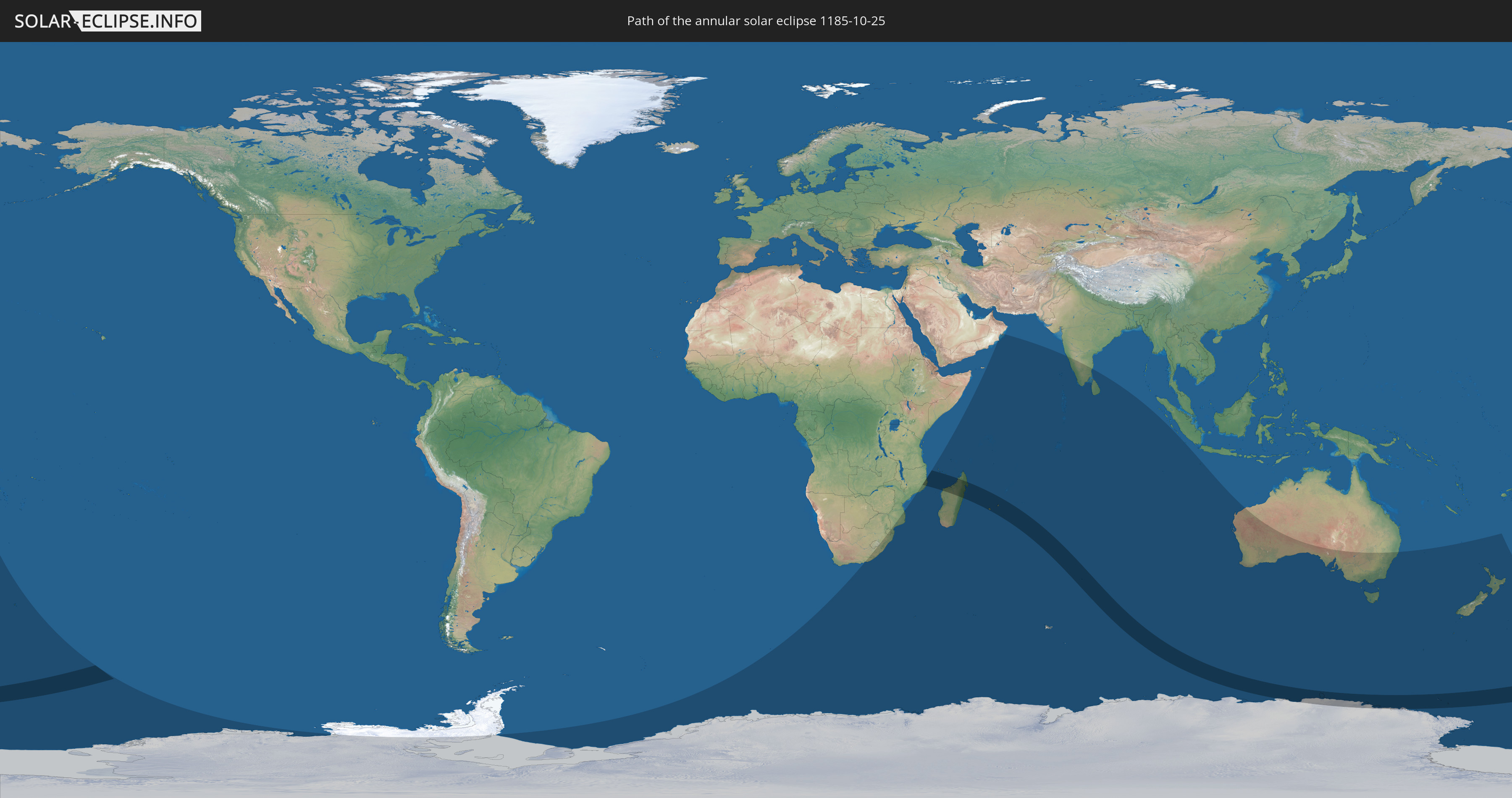
Annular solar eclipse of 10/25/1185
| Day of week: | Friday |
| Maximum duration of eclipse: | 06m24s |
| Maximum width of eclipse path: | 328 km |
| Saros cycle: | 120 |
| Coverage: | 93.1% |
| Magnitude: | 0.9308 |
| Gamma: | -0.6233 |
Wo kann man die Sonnenfinsternis vom 10/25/1185 sehen?
Die Sonnenfinsternis am 10/25/1185 kann man in 22 Ländern als partielle Sonnenfinsternis beobachten.
Der Finsternispfad verläuft durch 7 Länder. Nur in diesen Ländern ist sie als annular Sonnenfinsternis zu sehen.
In den folgenden Ländern ist die Sonnenfinsternis annular zu sehen
 Antarctica
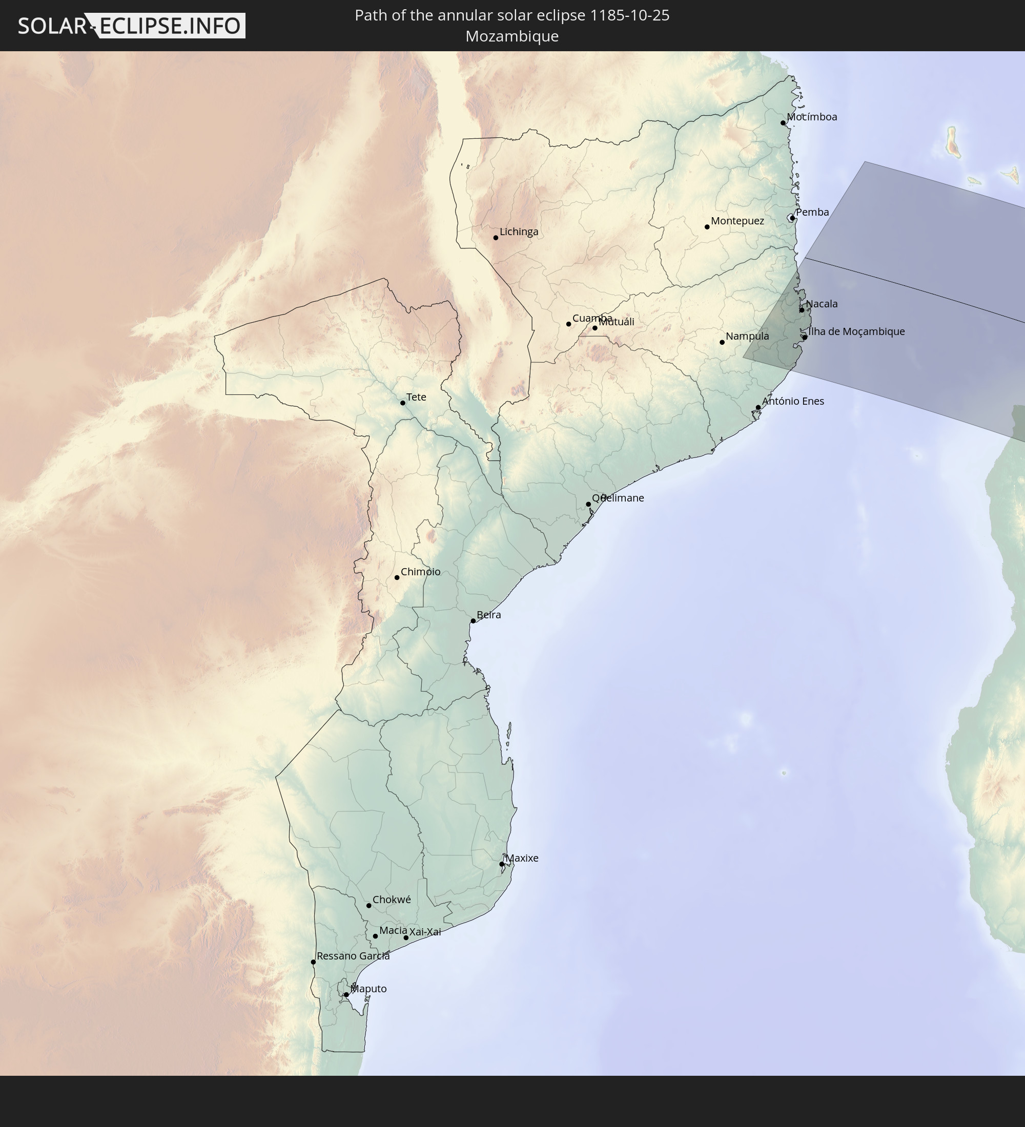 Mozambique
 French Southern and Antarctic Lands
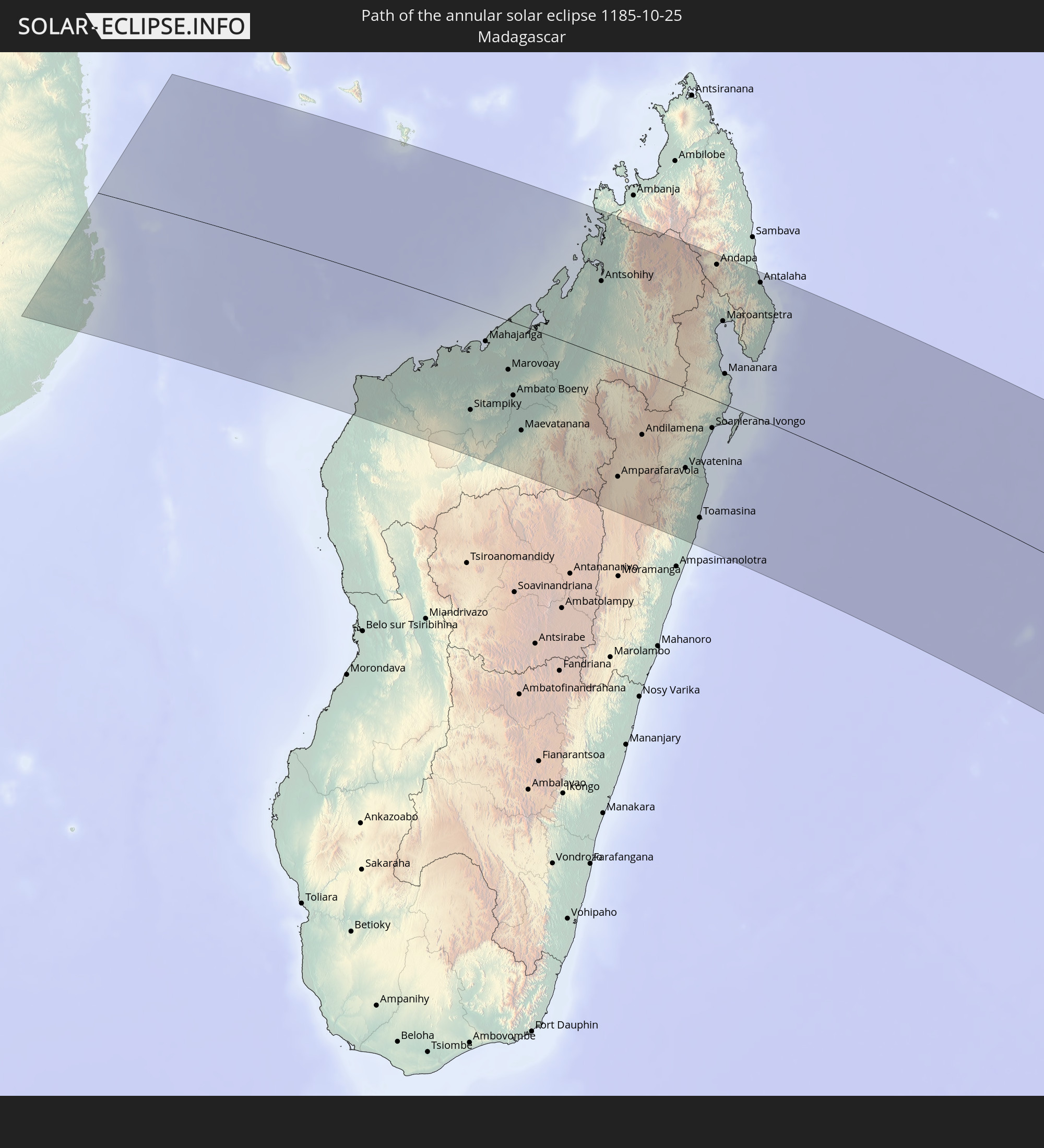 Madagascar
 Mayotte
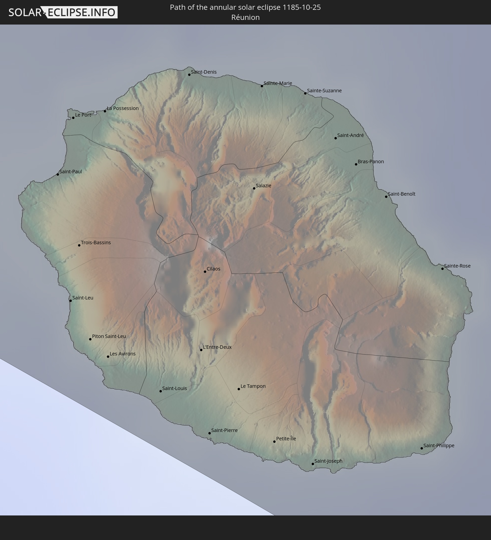 Réunion
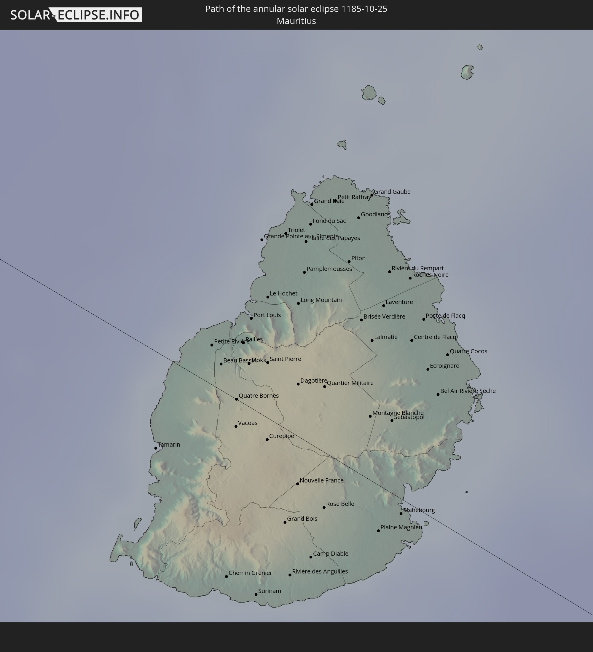 Mauritius
In den folgenden Ländern ist die Sonnenfinsternis partiell zu sehen
 Antarctica
 New Zealand
 South Africa
 Lesotho
 Mozambique
 Swaziland
 French Southern and Antarctic Lands
 Madagascar
 Comoros
 Mayotte
 Seychelles
 Oman
Oman
 Réunion
 Mauritius
 India
India
 British Indian Ocean Territory
 Heard Island and McDonald Islands
 Maldives
 Sri Lanka
 Cocos Islands
 Christmas Island
 Australia
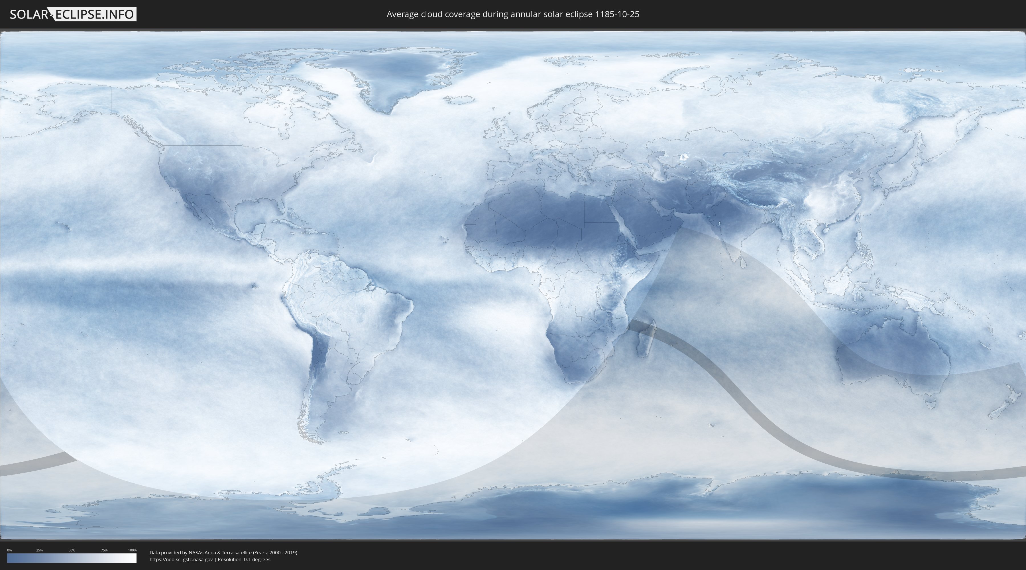
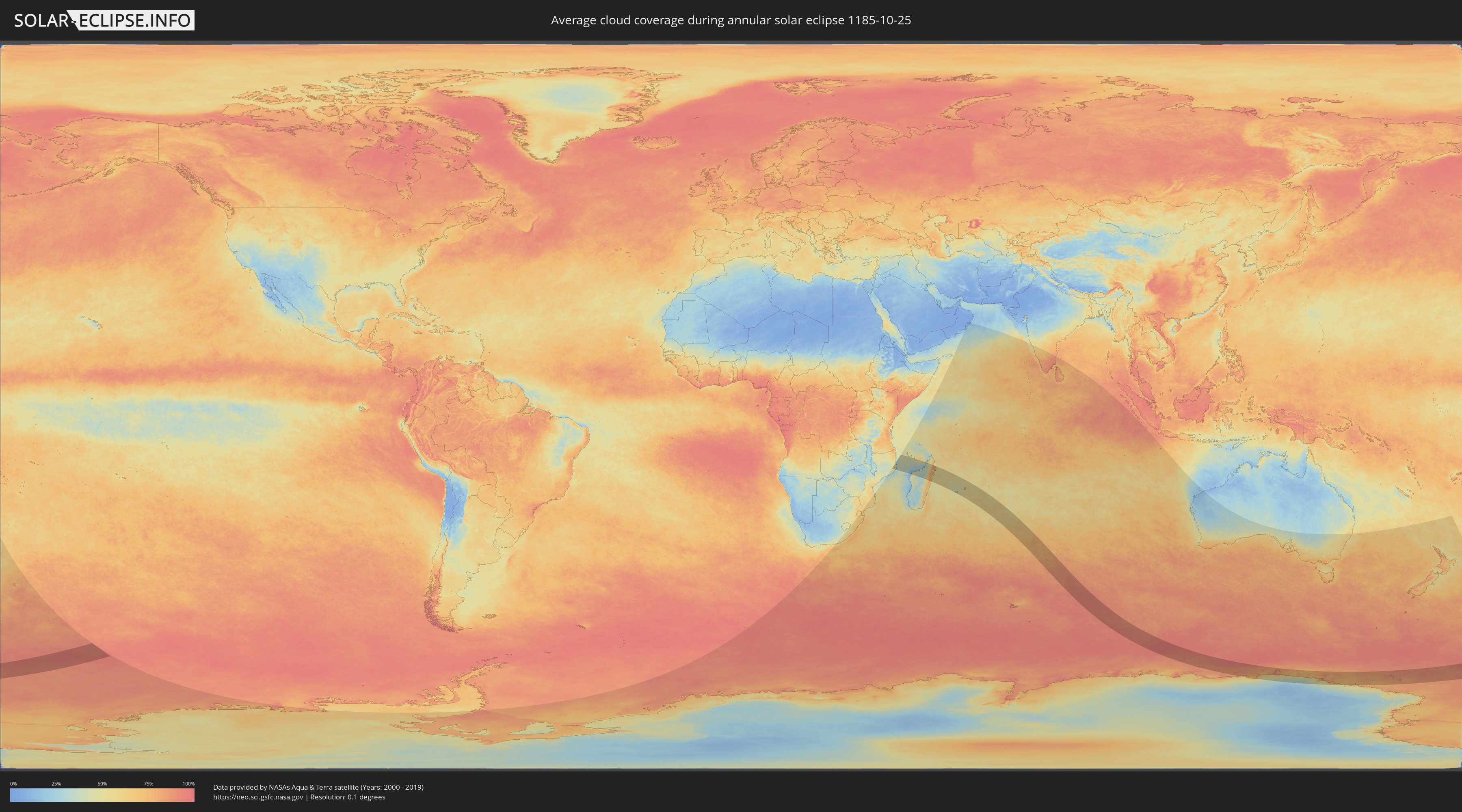
How will be the weather during the annular solar eclipse on 10/25/1185?
Where is the best place to see the annular solar eclipse of 10/25/1185?
The following maps show the average cloud coverage for the day of the annular solar eclipse.
With the help of these maps, it is possible to find the place along the eclipse path, which has the best
chance of a cloudless sky.
Nevertheless, you should consider local circumstances and inform about the weather of your chosen
observation site.
The data is provided by NASAs satellites
AQUA and TERRA.
The cloud maps are averaged over a period of 19 years (2000 - 2019).
Detailed country maps
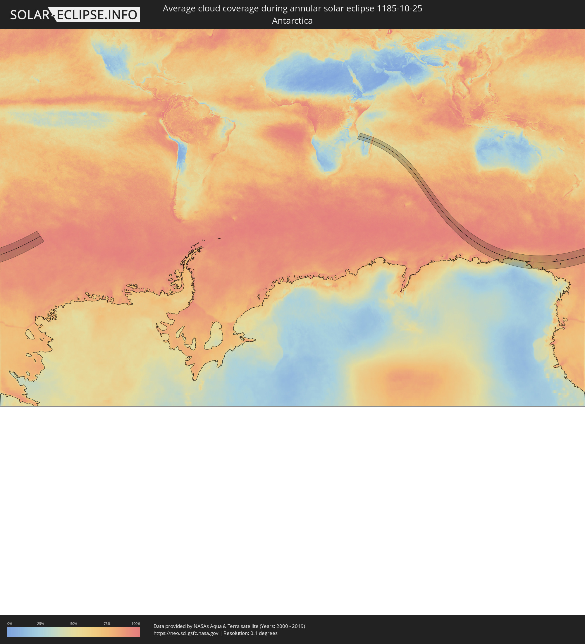 Antarctica
 Mozambique
 French Southern and Antarctic Lands
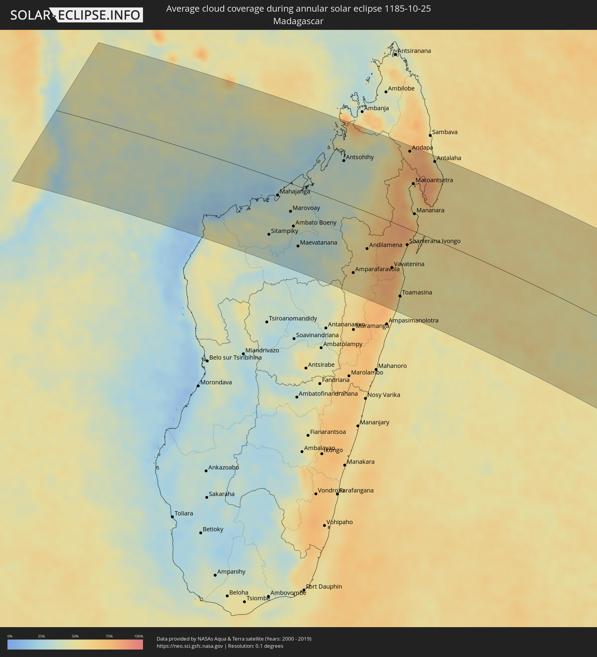 Madagascar
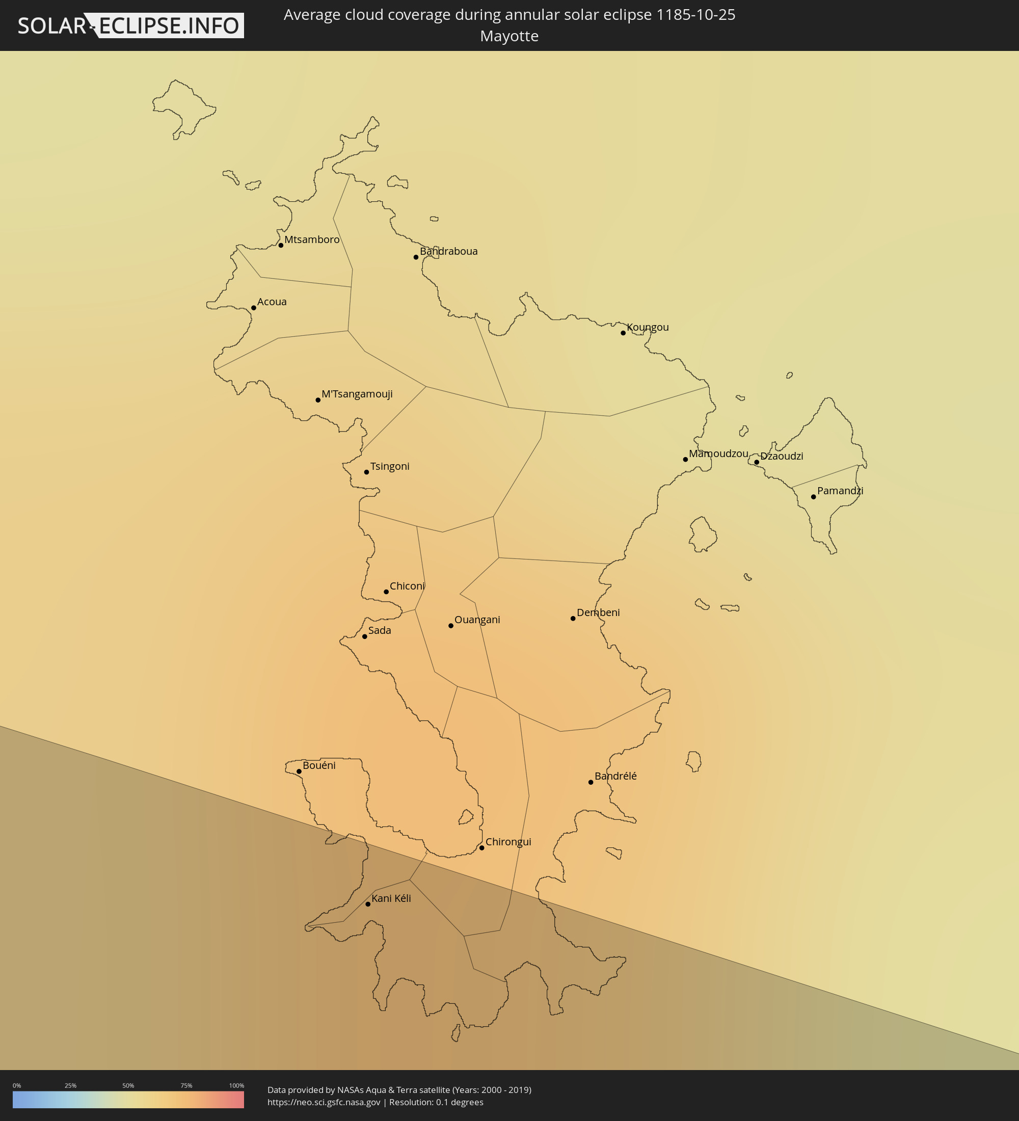 Mayotte
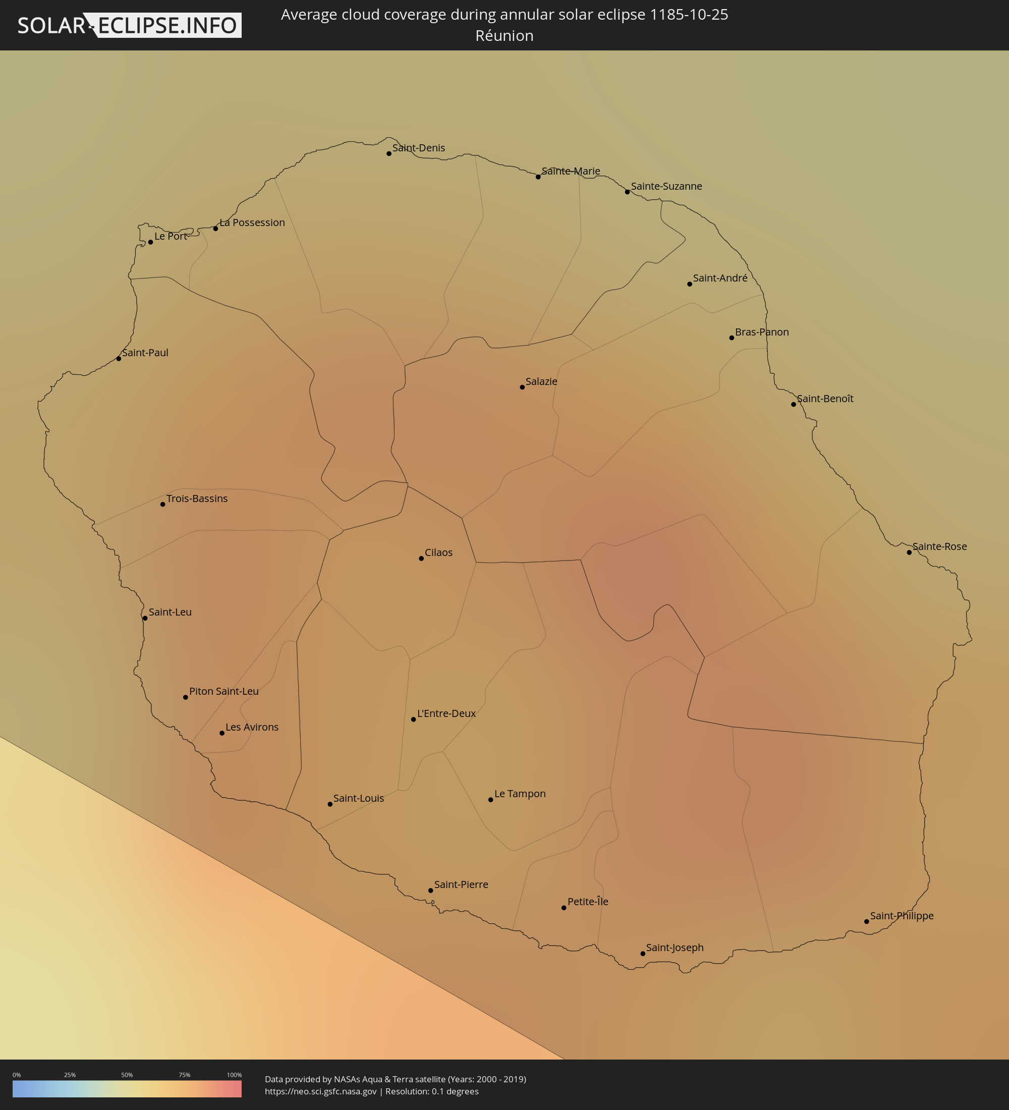 Réunion
 Mauritius
Cities inside the path of the eclipse
The following table shows all locations with a population of more than 5,000 inside the eclipse path. Cities which have more than 100,000 inhabitants are marked bold. A click at the locations opens a detailed map.
| City | Type | Eclipse duration | Local time of max. eclipse | Distance to central line | Ø Cloud coverage |
|
Nacala, Nampula
|
annular | - | 04:58:43 UTC+02:10 | 100 km | 46% |
|
Ilha de Moçambique, Nampula
|
annular | - | 04:59:19 UTC+02:10 | 149 km | 37% |
|
Kani Kéli, Kani-Kéli
|
annular | - | 05:12:20 UTC+02:27 | 208 km | 51% |
|
Sitampiky, Boeny
|
annular | - | 05:17:12 UTC+02:27 | 149 km | 41% |
|
Mahajanga, Boeny
|
annular | - | 05:15:49 UTC+02:27 | 42 km | 37% |
|
Marovoay, Boeny
|
annular | - | 05:16:19 UTC+02:27 | 71 km | 34% |
|
Ambato Boeny, Boeny
|
annular | - | 05:16:49 UTC+02:27 | 106 km | 36% |
|
Maevatanana, Betsiboka
|
annular | - | 05:17:30 UTC+02:27 | 152 km | 31% |
|
Tsaratanana, Betsiboka
|
annular | - | 05:17:09 UTC+02:27 | 105 km | 34% |
|
Antsohihy, Sofia
|
annular | - | 05:14:22 UTC+02:27 | 107 km | 33% |
|
Amparafaravola, Alaotra Mangoro
|
annular | - | 05:18:15 UTC+02:27 | 165 km | 55% |
|
Ambatondrazaka, Alaotra Mangoro
|
annular | - | 05:18:36 UTC+02:27 | 183 km | 53% |
|
Bemaitso, Alaotra Mangoro
|
annular | - | 05:17:27 UTC+02:27 | 100 km | 59% |
|
Andilamena, Alaotra Mangoro
|
annular | - | 05:17:22 UTC+02:27 | 91 km | 60% |
|
Bealanana, Sofia
|
annular | - | 05:13:47 UTC+02:27 | 171 km | 39% |
|
Antsirabe Afovoany, Sofia
|
annular | - | 05:15:46 UTC+02:27 | 34 km | 62% |
|
Sahatavy, Analanjirofo
|
annular | - | 05:17:59 UTC+02:27 | 120 km | 80% |
|
Vohibinany, Atsinanana
|
annular | - | 05:17:49 UTC+02:27 | 108 km | 78% |
|
Vavatenina, Analanjirofo
|
annular | - | 05:17:59 UTC+02:27 | 113 km | 81% |
|
Toamasina, Atsinanana
|
annular | - | 05:19:00 UTC+02:27 | 175 km | 54% |
|
Fenoarivo Atsinanana, Analanjirofo
|
annular | - | 05:17:50 UTC+02:27 | 96 km | 62% |
|
Mahavelona, Atsinanana
|
annular | - | 05:18:17 UTC+02:27 | 123 km | 52% |
|
Soanierana Ivongo, Analanjirofo
|
annular | - | 05:17:08 UTC+02:27 | 41 km | 56% |
|
Andapa, Sava
|
annular | - | 05:13:49 UTC+02:27 | 195 km | 77% |
|
Maroantsetra, Analanjirofo
|
annular | - | 05:14:56 UTC+02:27 | 118 km | 57% |
|
Mananara, Analanjirofo
|
annular | - | 05:16:00 UTC+02:27 | 43 km | 65% |
|
Antakotako, Analanjirofo
|
annular | - | 05:14:46 UTC+02:27 | 133 km | 71% |
|
Ambodifotatra, Analanjirofo
|
annular | - | 05:17:12 UTC+02:27 | 37 km | 53% |
|
Ampahana, Sava
|
annular | - | 05:13:54 UTC+02:27 | 208 km | 61% |
|
Antalaha, Sava
|
annular | - | 05:14:07 UTC+02:27 | 195 km | 55% |
|
Saint-Paul, Réunion
|
annular | - | 06:38:23 UTC+03:41 | 188 km | 79% |
|
Saint-Leu, Réunion
|
annular | - | 06:38:39 UTC+03:41 | 202 km | 65% |
|
Le Port, Réunion
|
annular | - | 06:38:16 UTC+03:41 | 180 km | 75% |
|
Trois-Bassins, Réunion
|
annular | - | 06:38:32 UTC+03:41 | 195 km | 78% |
|
Piton Saint-Leu, Réunion
|
annular | - | 06:38:45 UTC+03:41 | 206 km | 65% |
|
La Possession, Réunion
|
annular | - | 06:38:15 UTC+03:41 | 177 km | 75% |
|
Les Avirons, Réunion
|
annular | - | 06:38:47 UTC+03:41 | 207 km | 65% |
|
Saint-Louis, Réunion
|
annular | - | 06:38:52 UTC+03:41 | 207 km | 56% |
|
Saint-Denis, Réunion
|
annular | - | 06:38:11 UTC+03:41 | 166 km | 78% |
|
L'Entre-Deux, Réunion
|
annular | - | 06:38:47 UTC+03:41 | 199 km | 78% |
|
Cilaos, Réunion
|
annular | - | 06:38:37 UTC+03:41 | 189 km | 72% |
|
Saint-Pierre, Réunion
|
annular | - | 06:38:58 UTC+03:41 | 209 km | 66% |
|
Le Tampon, Réunion
|
annular | - | 06:38:53 UTC+03:41 | 201 km | 66% |
|
Salazie, Réunion
|
annular | - | 06:38:27 UTC+03:41 | 176 km | 78% |
|
Sainte-Marie, Réunion
|
annular | - | 06:38:13 UTC+03:41 | 162 km | 78% |
|
Petite-Île, Réunion
|
annular | - | 06:39:00 UTC+03:41 | 205 km | 55% |
|
Sainte-Suzanne, Réunion
|
annular | - | 06:38:15 UTC+03:41 | 160 km | 74% |
|
Saint-Joseph, Réunion
|
annular | - | 06:39:03 UTC+03:41 | 205 km | 55% |
|
Saint-André, Réunion
|
annular | - | 06:38:21 UTC+03:41 | 164 km | 73% |
|
Bras-Panon, Réunion
|
annular | - | 06:38:25 UTC+03:41 | 165 km | 73% |
|
Saint-Benoît, Réunion
|
annular | - | 06:38:29 UTC+03:41 | 167 km | 73% |
|
Saint-Philippe, Réunion
|
annular | - | 06:39:03 UTC+03:41 | 196 km | 58% |
|
Sainte-Rose, Réunion
|
annular | - | 06:38:39 UTC+03:41 | 172 km | 71% |
|
Chemin Grenier, Savanne
|
annular | - | 06:45:56 UTC+03:50 | 22 km | 61% |
|
Vacoas, Plaines Wilhems
|
annular | - | 06:45:37 UTC+03:50 | 3 km | 79% |
|
Pailles, Moka
|
annular | - | 06:45:26 UTC+03:50 | 7 km | 75% |
|
Moka, Moka
|
annular | - | 06:45:29 UTC+03:50 | 5 km | 75% |
|
Port Louis, Port Louis
|
annular | - | 06:45:23 UTC+03:50 | 11 km | 75% |
|
Surinam, Savanne
|
annular | - | 06:45:59 UTC+03:50 | 22 km | 61% |
|
Grande Pointe aux Piments, Pamplemousses
|
annular | - | 06:45:13 UTC+03:50 | 21 km | 75% |
|
Terre Rouge, Pamplemousses
|
annular | - | 06:45:20 UTC+03:50 | 16 km | 75% |
|
Grand Bois, Savanne
|
annular | - | 06:45:50 UTC+03:50 | 11 km | 80% |
|
Rivière des Anguilles, Savanne
|
annular | - | 06:45:57 UTC+03:50 | 17 km | 60% |
|
Morcellemont Saint André, Pamplemousses
|
annular | - | 06:45:14 UTC+03:50 | 22 km | 80% |
|
Nouvelle France, Grand Port
|
annular | - | 06:45:45 UTC+03:50 | 6 km | 77% |
|
Dagotière, Moka
|
annular | - | 06:45:32 UTC+03:50 | 6 km | 84% |
|
Long Mountain, Pamplemousses
|
annular | - | 06:45:22 UTC+03:50 | 16 km | 80% |
|
Pamplemousses, Pamplemousses
|
annular | - | 06:45:18 UTC+03:50 | 20 km | 80% |
|
Plaine des Papayes, Pamplemousses
|
annular | - | 06:45:14 UTC+03:50 | 24 km | 80% |
|
Fond du Sac, Pamplemousses
|
annular | - | 06:45:12 UTC+03:50 | 26 km | 68% |
|
Grand Baie, Rivière du Rempart
|
annular | - | 06:45:09 UTC+03:50 | 29 km | 68% |
|
Rose Belle, Grand Port
|
annular | - | 06:45:49 UTC+03:50 | 7 km | 77% |
|
Quartier Militaire, Moka
|
annular | - | 06:45:33 UTC+03:50 | 8 km | 84% |
|
Petit Raffray, Rivière du Rempart
|
annular | - | 06:45:09 UTC+03:50 | 31 km | 68% |
|
New Grove, Grand Port
|
annular | - | 06:45:50 UTC+03:50 | 7 km | 77% |
|
Piton, Rivière du Rempart
|
annular | - | 06:45:17 UTC+03:50 | 25 km | 80% |
|
Goodlands, Rivière du Rempart
|
annular | - | 06:45:11 UTC+03:50 | 31 km | 68% |
|
Brisée Verdière, Flacq
|
annular | - | 06:45:25 UTC+03:50 | 19 km | 84% |
|
Bon Accueil, Flacq
|
annular | - | 06:45:26 UTC+03:50 | 18 km | 81% |
|
Montagne Blanche
|
annular | - | 06:45:37 UTC+03:50 | 8 km | 76% |
|
Grand Gaube, Rivière du Rempart
|
annular | - | 06:45:09 UTC+03:50 | 34 km | 58% |
|
Lalmatie, Flacq
|
annular | - | 06:45:28 UTC+03:50 | 17 km | 81% |
|
Plaine Magnien, Grand Port
|
annular | - | 06:45:53 UTC+03:50 | 6 km | 66% |
|
Laventure, Flacq
|
annular | - | 06:45:23 UTC+03:50 | 22 km | 71% |
|
Rivière du Rempart, Rivière du Rempart
|
annular | - | 06:45:19 UTC+03:50 | 26 km | 71% |
|
Sebastopol, Flacq
|
annular | - | 06:45:38 UTC+03:50 | 9 km | 76% |
|
Beau Vallon, Grand Port
|
annular | - | 06:45:52 UTC+03:50 | 3 km | 66% |
|
Mahébourg, Grand Port
|
annular | - | 06:45:51 UTC+03:50 | 2 km | 66% |
|
Roches Noire, Rivière du Rempart
|
annular | - | 06:45:20 UTC+03:50 | 27 km | 71% |
|
Centre de Flacq, Flacq
|
annular | - | 06:45:28 UTC+03:50 | 20 km | 81% |
|
Poste de Flacq, Flacq
|
annular | - | 06:45:26 UTC+03:50 | 23 km | 81% |
|
Ecroignard, Flacq
|
annular | - | 06:45:32 UTC+03:50 | 17 km | 81% |
|
Quatre Cocos, Flacq
|
annular | - | 06:45:30 UTC+03:50 | 21 km | 64% |