Annular solar eclipse of 11/05/1203
| Day of week: | Wednesday |
| Maximum duration of eclipse: | 06m23s |
| Maximum width of eclipse path: | 323 km |
| Saros cycle: | 120 |
| Coverage: | 93.1% |
| Magnitude: | 0.9307 |
| Gamma: | -0.6037 |
Wo kann man die Sonnenfinsternis vom 11/05/1203 sehen?

Die Sonnenfinsternis am 11/05/1203 kann man in 27 Ländern als partielle Sonnenfinsternis beobachten.
Der Finsternispfad verläuft durch 6 Länder. Nur in diesen Ländern ist sie als annular Sonnenfinsternis zu sehen.
In den folgenden Ländern ist die Sonnenfinsternis annular zu sehen
 Chile
Chile
 Peru
Peru
 Brazil
 Argentina
 Bolivia
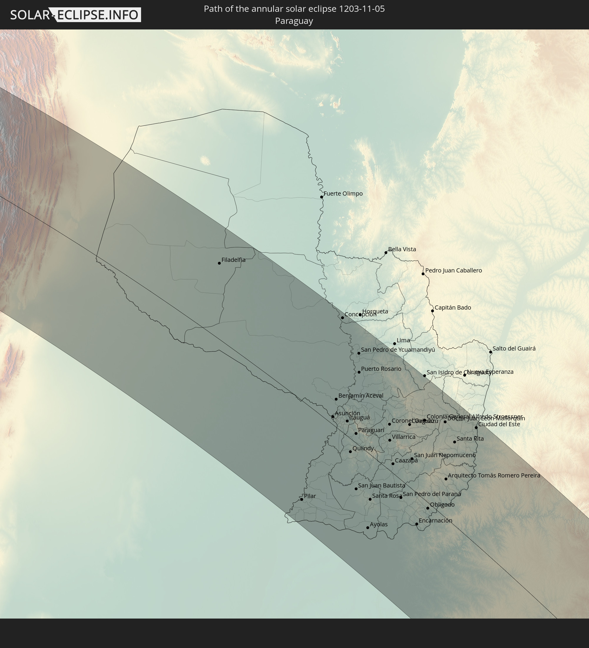 Paraguay
In den folgenden Ländern ist die Sonnenfinsternis partiell zu sehen
 Antarctica
 Chile
Chile
 Colombia
 Peru
Peru
 Brazil
 Argentina
 Venezuela
 Bolivia
 Paraguay
 Trinidad and Tobago
 Grenada
 Saint Vincent and the Grenadines
 Falkland Islands
 Guyana
 Martinique
 Saint Lucia
 Barbados
 Uruguay
 Suriname
 French Guiana
 South Georgia and the South Sandwich Islands
 Saint Helena, Ascension and Tristan da Cunha
 Bouvet Island
 South Africa
 Lesotho
 French Southern and Antarctic Lands
 Heard Island and McDonald Islands
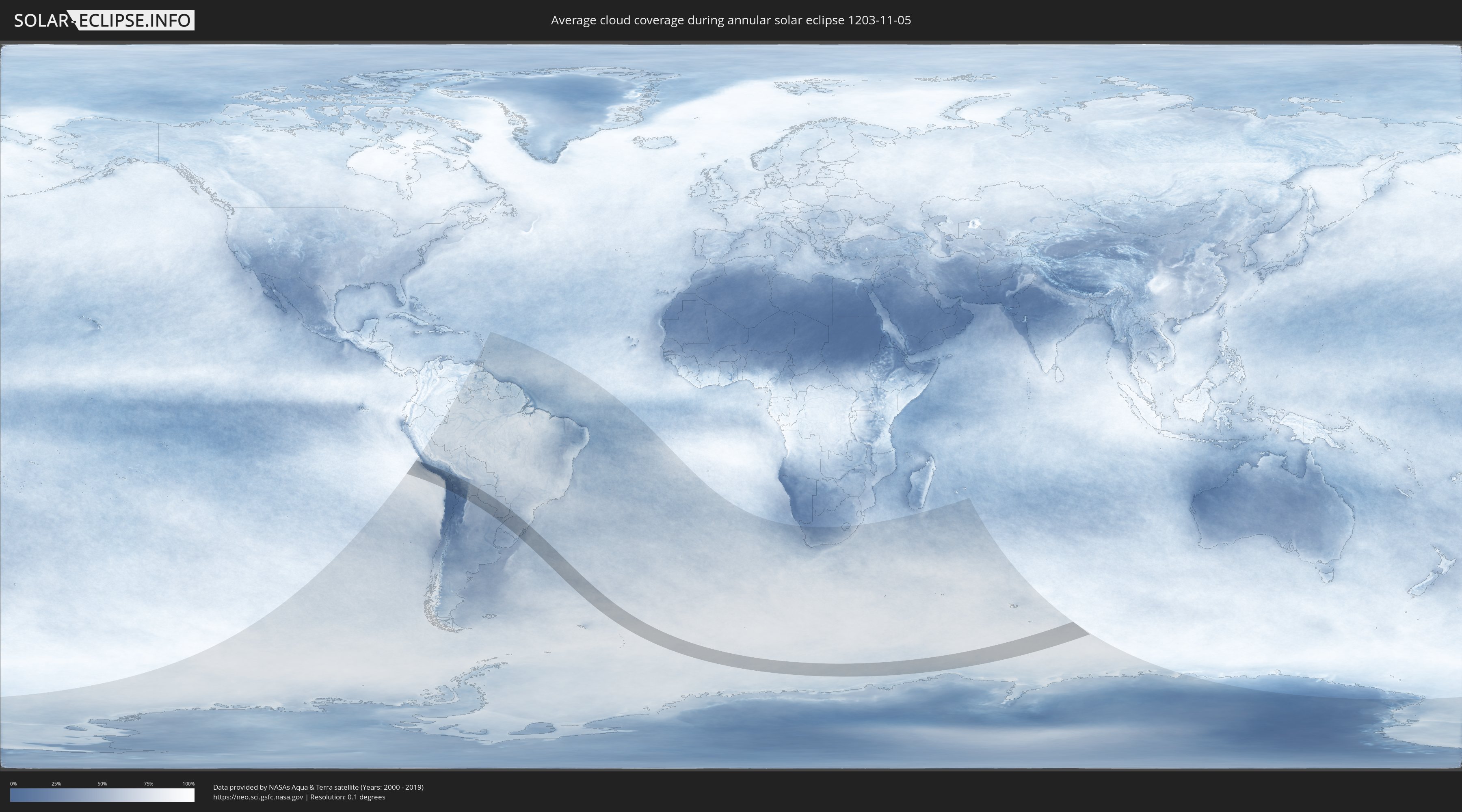
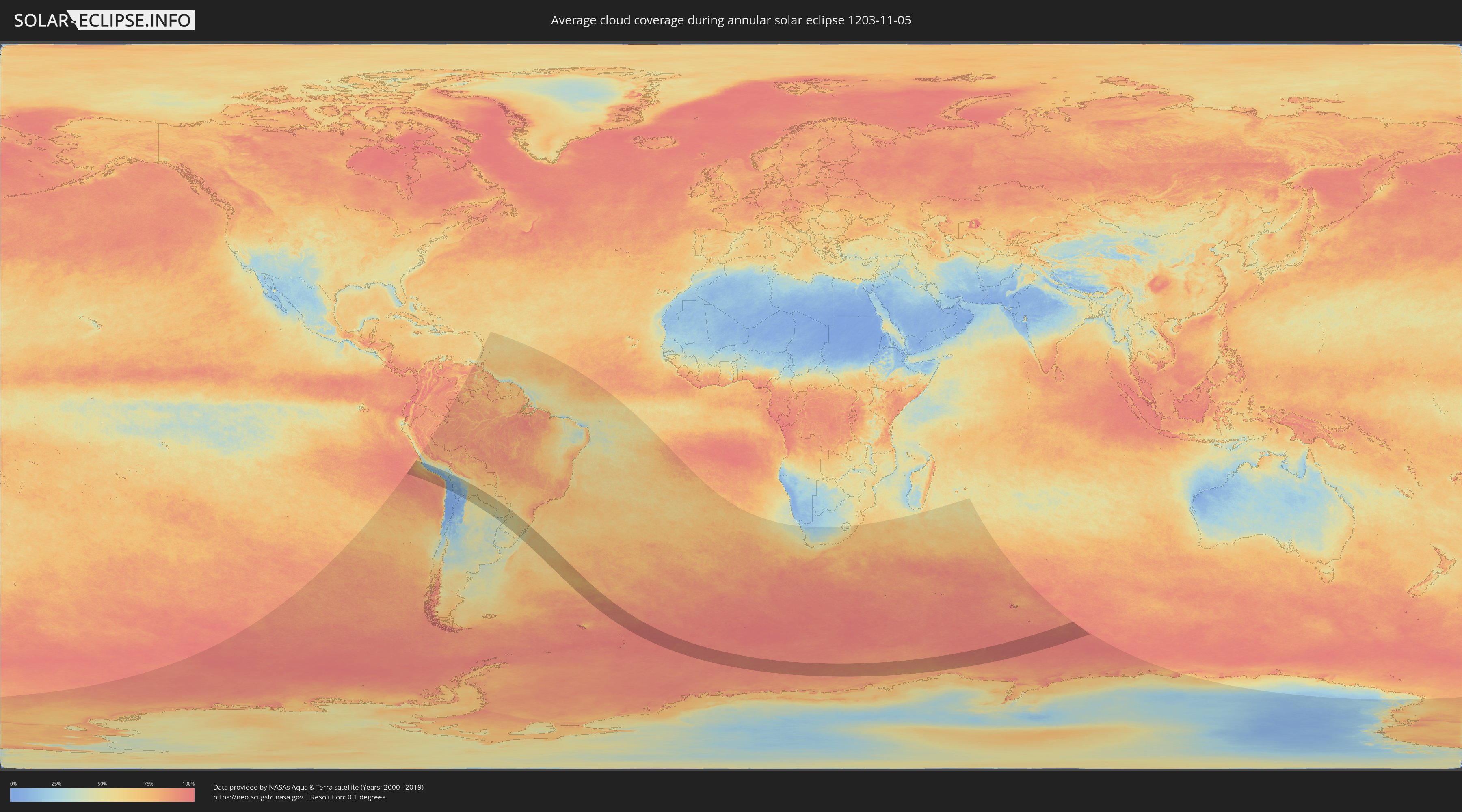
How will be the weather during the annular solar eclipse on 11/05/1203?
Where is the best place to see the annular solar eclipse of 11/05/1203?
The following maps show the average cloud coverage for the day of the annular solar eclipse.
With the help of these maps, it is possible to find the place along the eclipse path, which has the best
chance of a cloudless sky.
Nevertheless, you should consider local circumstances and inform about the weather of your chosen
observation site.
The data is provided by NASAs satellites
AQUA and TERRA.
The cloud maps are averaged over a period of 19 years (2000 - 2019).
Detailed country maps
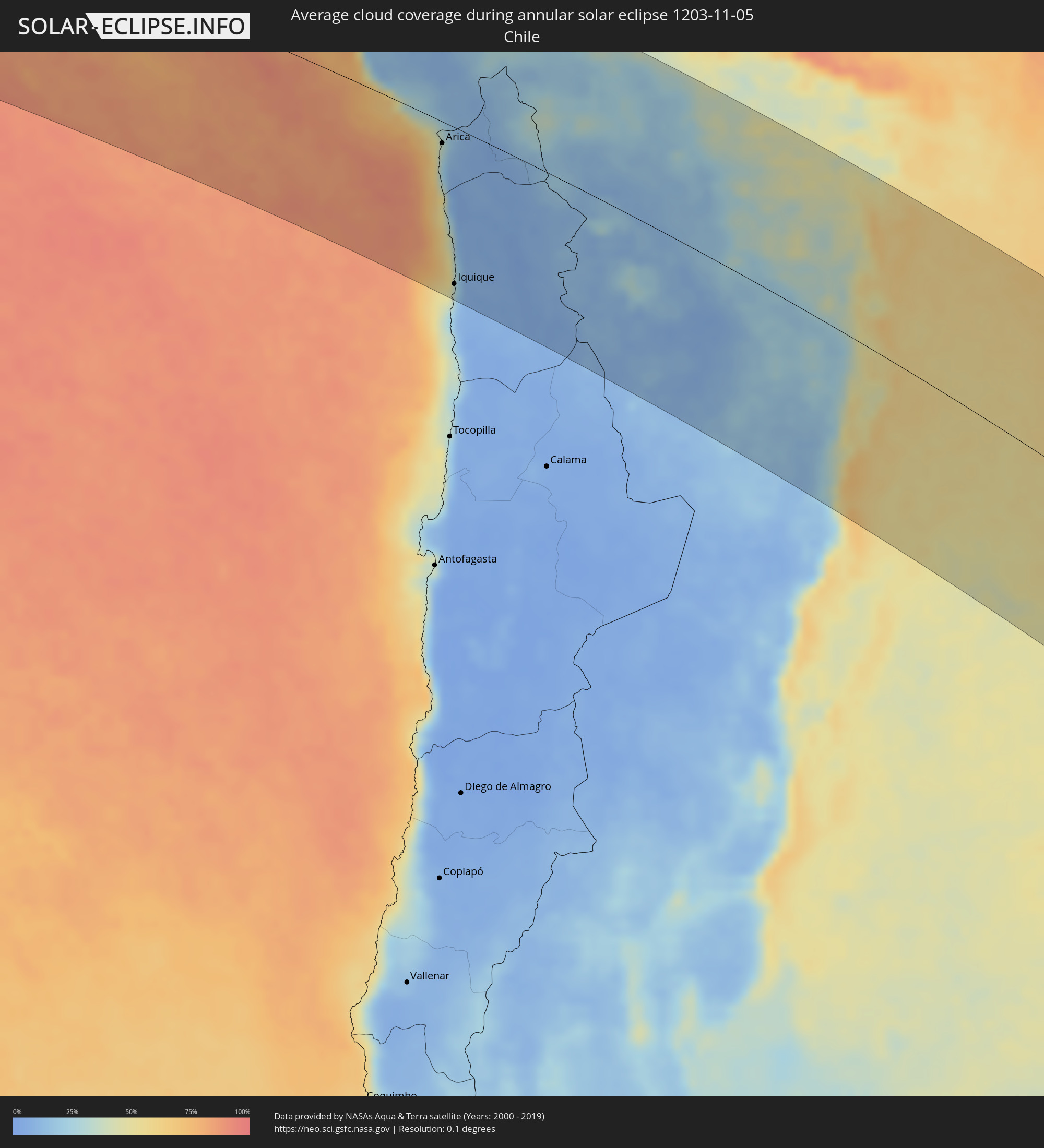 Chile
Chile
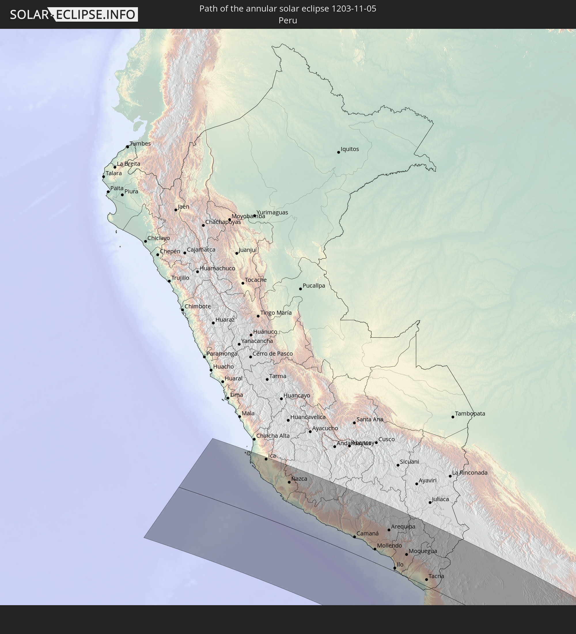
 Peru
Peru
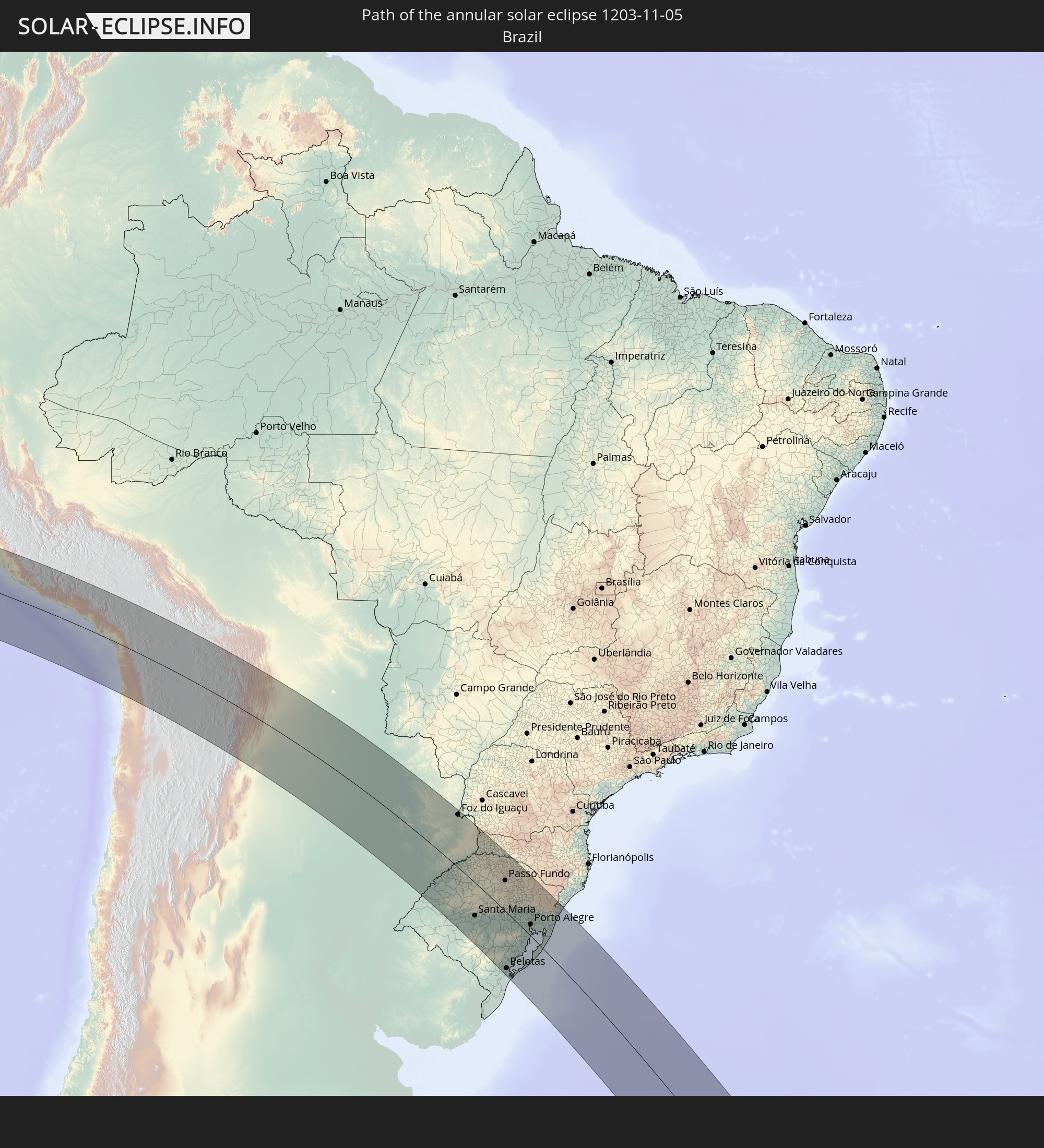
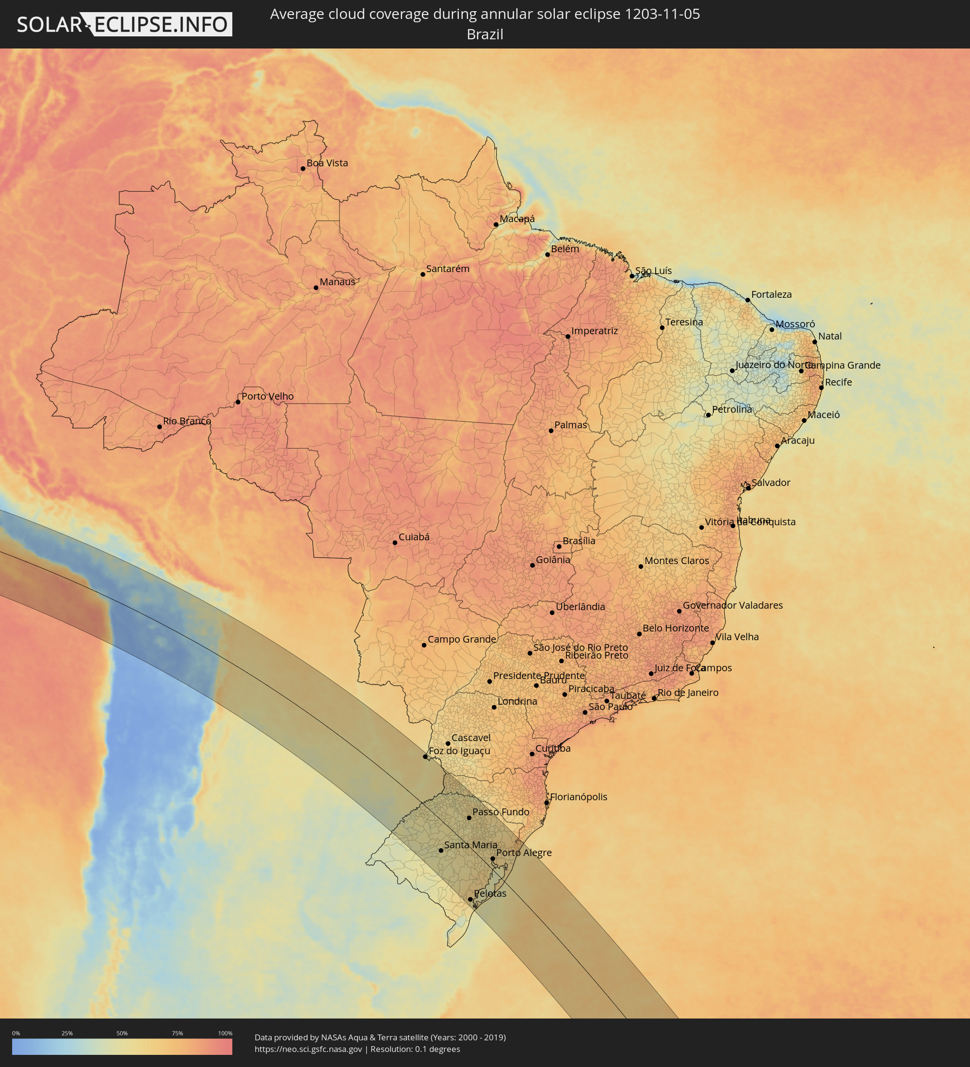 Brazil
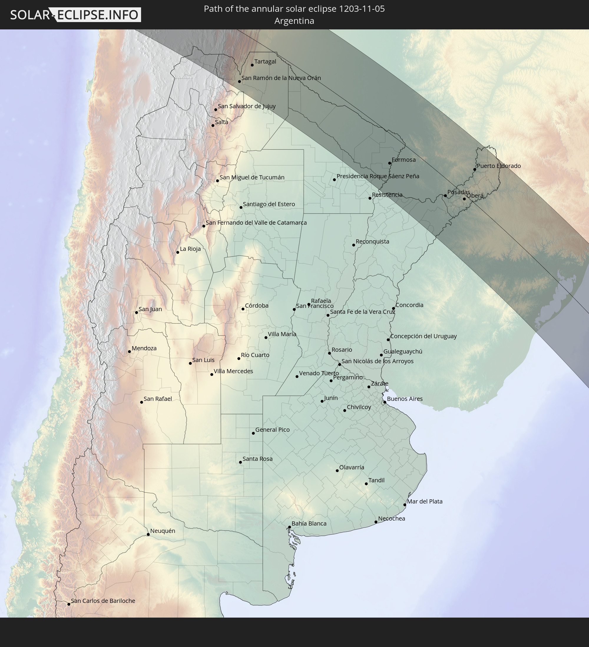
 Argentina
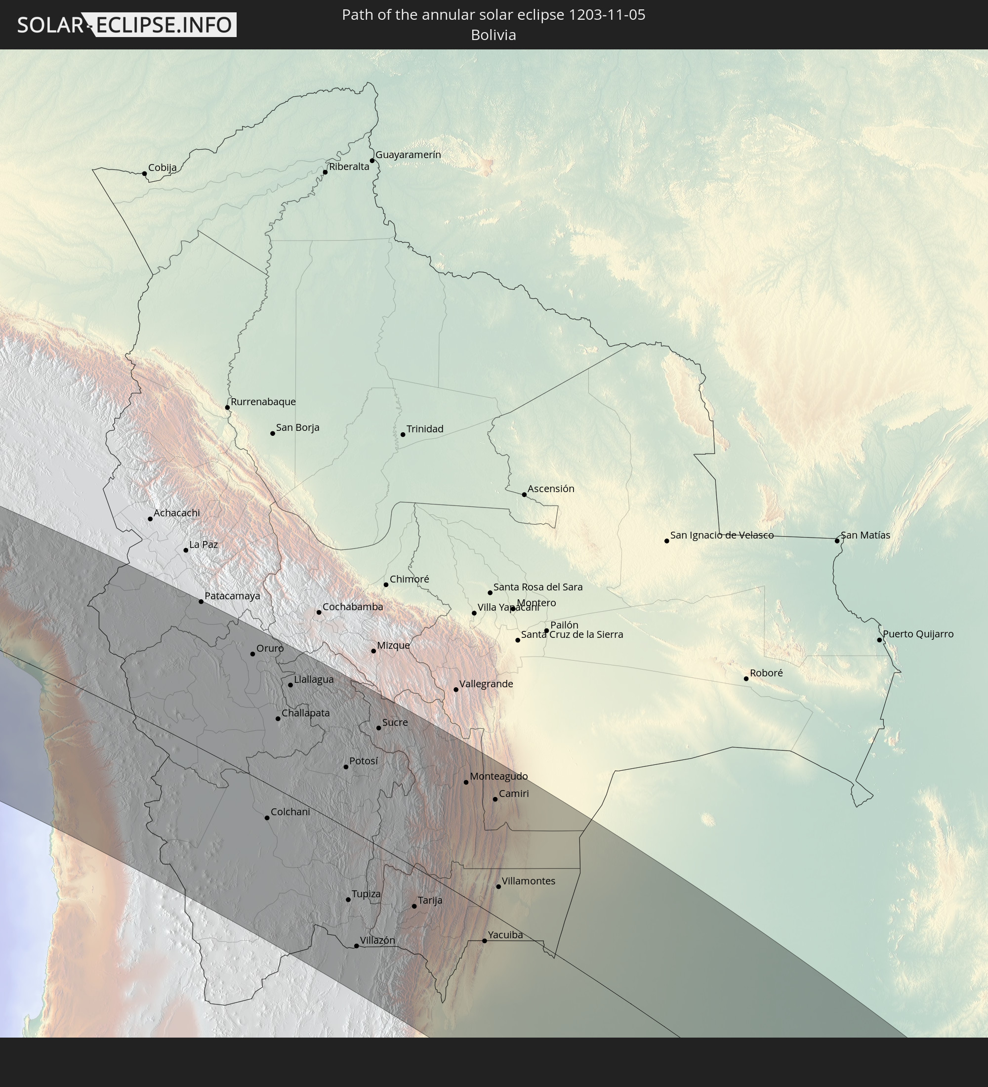
 Bolivia
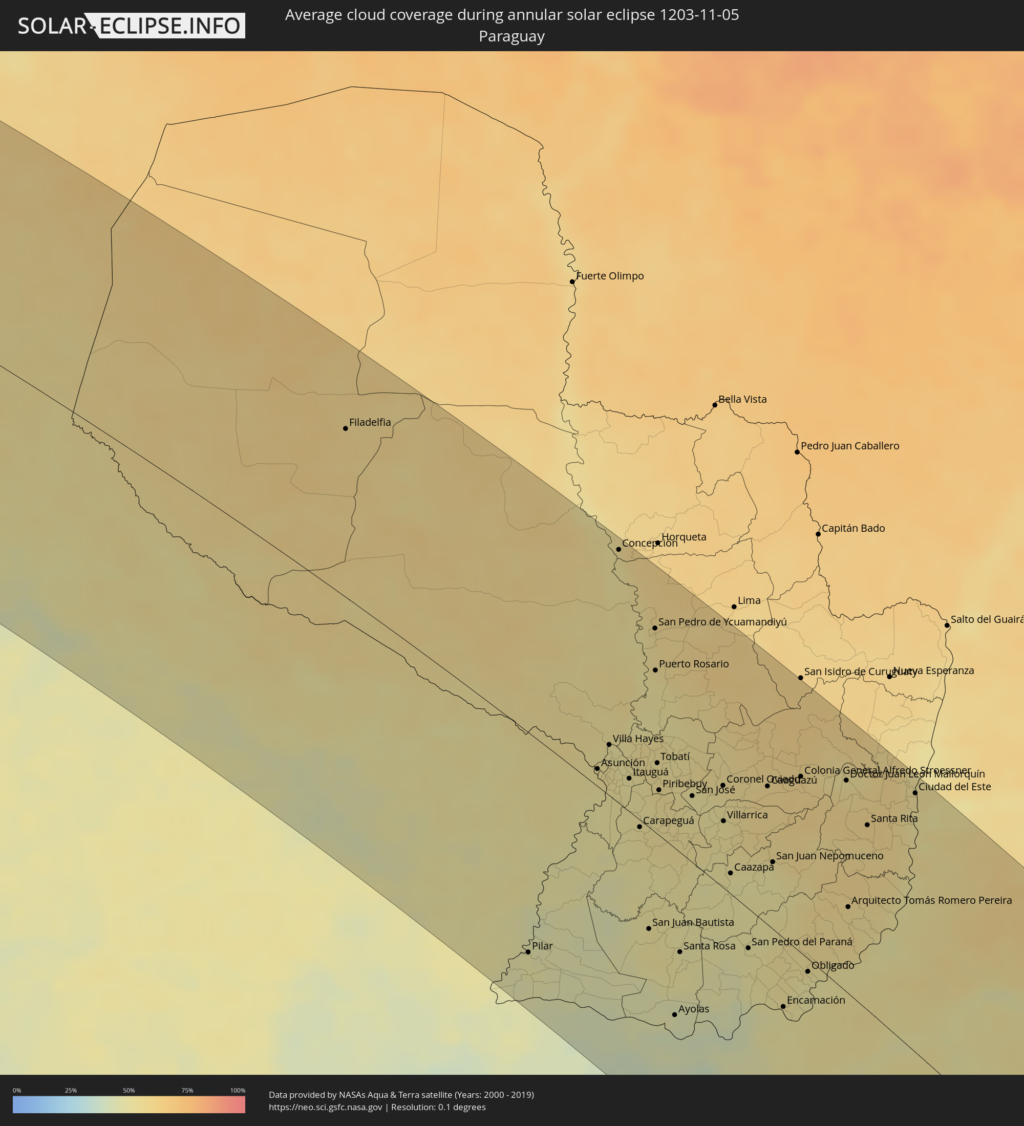 Paraguay
Cities inside the path of the eclipse
The following table shows all locations with a population of more than 5,000 inside the eclipse path. Cities which have more than 100,000 inhabitants are marked bold. A click at the locations opens a detailed map.
| City | Type | Eclipse duration | Local time of max. eclipse | Distance to central line | Ø Cloud coverage |
|
Subtanjalla, Ica
|
annular | - | 05:29:35 UTC-05:08 | 206 km | 28% |
|
San Juan Bautista, Ica
|
annular | - | 05:29:34 UTC-05:08 | 208 km | 31% |
|
Ica, Ica
|
annular | - | 05:29:38 UTC-05:08 | 203 km | 28% |
|
Santiago, Ica
|
annular | - | 05:29:46 UTC-05:08 | 192 km | 24% |
|
Los Aquijes, Ica
|
annular | - | 05:29:39 UTC-05:08 | 202 km | 28% |
|
Palpa, Ica
|
annular | - | 05:30:02 UTC-05:08 | 174 km | 21% |
|
Minas de Marcona, Ica
|
annular | - | 05:30:51 UTC-05:08 | 106 km | 24% |
|
Nazca, Ica
|
annular | - | 05:30:19 UTC-05:08 | 152 km | 19% |
|
Puquio, Ayacucho
|
annular | - | 05:29:54 UTC-05:08 | 198 km | 32% |
|
Tambo, Ayacucho
|
annular | - | 05:29:58 UTC-05:08 | 195 km | 32% |
|
Coracora, Ayacucho
|
annular | - | 05:30:13 UTC-05:08 | 177 km | 24% |
|
Camaná, Arequipa
|
annular | - | 05:32:01 UTC-05:08 | 57 km | 62% |
|
Mollendo, Arequipa
|
annular | - | 05:32:24 UTC-05:08 | 49 km | 68% |
|
Lluta, Arequipa
|
annular | - | 05:31:02 UTC-05:08 | 148 km | 14% |
|
Punta de Bombón, Arequipa
|
annular | - | 05:32:33 UTC-05:08 | 39 km | 69% |
|
Cocachacra, Arequipa
|
annular | - | 05:32:26 UTC-05:08 | 49 km | 67% |
|
Yura, Arequipa
|
annular | - | 05:31:16 UTC-05:08 | 139 km | 12% |
|
Arequipa, Arequipa
|
annular | - | 05:31:26 UTC-05:08 | 129 km | 12% |
|
Ilo, Moquegua
|
annular | - | 05:33:06 UTC-05:08 | 18 km | 51% |
|
Pacocha, Moquegua
|
annular | - | 05:33:01 UTC-05:08 | 21 km | 51% |
|
Moquegua, Moquegua
|
annular | - | 05:32:24 UTC-05:08 | 78 km | 12% |
|
Torata, Moquegua
|
annular | - | 05:32:13 UTC-05:08 | 92 km | 10% |
|
Ilabaya, Tacna
|
annular | - | 05:32:38 UTC-05:08 | 74 km | 10% |
|
Arica, Arica y Parinacota
|
annular | - | 05:59:55 UTC-04:42 | 35 km | 30% |
|
Tacna, Tacna
|
annular | - | 05:33:25 UTC-05:08 | 28 km | 16% |
|
Iquique, Tarapacá
|
annular | - | 06:02:27 UTC-04:42 | 196 km | 24% |
|
Patacamaya, La Paz
|
annular | - | 06:07:57 UTC-04:32 | 208 km | 34% |
|
Oruro, Oruro
|
annular | - | 06:08:57 UTC-04:32 | 170 km | 22% |
|
Colchani, Potosí
|
annular | - | 06:12:25 UTC-04:32 | 54 km | 9% |
|
Huanuni, Oruro
|
annular | - | 06:09:22 UTC-04:32 | 155 km | 36% |
|
Uyuni, Potosí
|
annular | - | 06:12:39 UTC-04:32 | 58 km | 7% |
|
Challapata, Oruro
|
annular | - | 06:10:17 UTC-04:32 | 101 km | 18% |
|
Llallagua, Potosí
|
annular | - | 06:09:33 UTC-04:32 | 154 km | 37% |
|
Potosí, Potosí
|
annular | - | 06:11:15 UTC-04:32 | 83 km | 38% |
|
Tupiza, Potosí
|
annular | - | 06:14:09 UTC-04:32 | 101 km | 19% |
|
Villazón, Potosí
|
annular | - | 06:15:11 UTC-04:32 | 152 km | 13% |
|
La Quiaca, Jujuy Province
|
annular | - | 06:31:00 UTC-04:16 | 154 km | 13% |
|
Sucre, Chuquisaca
|
annular | - | 06:10:23 UTC-04:32 | 160 km | 45% |
|
Tarija, Tarija
|
annular | - | 06:14:18 UTC-04:32 | 53 km | 47% |
|
San Ramón de la Nueva Orán, Salta Province
|
annular | - | 06:32:44 UTC-04:16 | 183 km | 53% |
|
Embarcación, Salta Province
|
annular | - | 06:32:52 UTC-04:16 | 179 km | 52% |
|
Monteagudo, Chuquisaca
|
annular | - | 06:11:32 UTC-04:32 | 156 km | 59% |
|
Tartagal, Salta Province
|
annular | - | 06:31:43 UTC-04:16 | 98 km | 52% |
|
Yacuiba, Tarija
|
annular | - | 06:15:06 UTC-04:32 | 42 km | 54% |
|
Camiri, Santa Cruz
|
annular | - | 06:11:55 UTC-04:32 | 157 km | 59% |
|
Villamontes, Tarija
|
annular | - | 06:13:53 UTC-04:32 | 46 km | 55% |
|
Ingeniero Guillermo N. Juárez, Formosa Province
|
annular | - | 06:34:13 UTC-04:16 | 117 km | 53% |
|
Las Lomitas, Formosa Province
|
annular | - | 06:35:49 UTC-04:16 | 115 km | 51% |
|
Filadelfia, Boquerón
|
annular | - | 06:57:55 UTC-03:50 | 137 km | 58% |
|
Pampa del Indio, Chaco Province
|
annular | - | 06:38:22 UTC-04:16 | 197 km | 48% |
|
El Colorado, Formosa Province
|
annular | - | 06:38:55 UTC-04:16 | 185 km | 49% |
|
General José de San Martín, Chaco Province
|
annular | - | 06:39:21 UTC-04:16 | 201 km | 47% |
|
Pirané, Formosa Province
|
annular | - | 06:37:56 UTC-04:16 | 116 km | 50% |
|
La Leonesa, Chaco Province
|
annular | - | 06:40:26 UTC-04:16 | 205 km | 47% |
|
Pilar, Ñeembucú
|
annular | - | 07:06:21 UTC-03:50 | 167 km | 48% |
|
Formosa, Formosa Province
|
annular | - | 06:38:58 UTC-04:16 | 98 km | 47% |
|
Clorinda, Formosa Province
|
annular | - | 06:37:27 UTC-04:16 | 9 km | 51% |
|
Asunción, Asunción
|
annular | - | 07:03:38 UTC-03:50 | 31 km | 53% |
|
Benjamín Aceval, Presidente Hayes
|
annular | - | 07:03:02 UTC-03:50 | 47 km | 52% |
|
Limpio, Central
|
annular | - | 07:03:25 UTC-03:50 | 42 km | 54% |
|
Guarambaré, Central
|
annular | - | 07:04:01 UTC-03:50 | 8 km | 50% |
|
Capiatá, Central
|
annular | - | 07:03:47 UTC-03:50 | 22 km | 51% |
|
Concepción, Concepción
|
annular | - | 07:00:15 UTC-03:50 | 194 km | 54% |
|
Areguá, Central
|
annular | - | 07:03:43 UTC-03:50 | 28 km | 51% |
|
Itá, Central
|
annular | - | 07:04:04 UTC-03:50 | 14 km | 51% |
|
Emboscada, Cordillera
|
annular | - | 07:03:26 UTC-03:50 | 47 km | 50% |
|
Yaguarón, Paraguarí
|
annular | - | 07:04:16 UTC-03:50 | 21 km | 51% |
|
Ypacarai, Central
|
annular | - | 07:03:55 UTC-03:50 | 26 km | 51% |
|
Paraguarí, Paraguarí
|
annular | - | 07:04:21 UTC-03:50 | 35 km | 51% |
|
San Juan Bautista, Misiones
|
annular | - | 07:06:18 UTC-03:50 | 78 km | 51% |
|
Caacupé, Cordillera
|
annular | - | 07:03:55 UTC-03:50 | 40 km | 53% |
|
San Pedro de Ycuamandiyú, San Pedro
|
annular | - | 07:01:33 UTC-03:50 | 154 km | 56% |
|
Tobatí, Cordillera
|
annular | - | 07:03:41 UTC-03:50 | 55 km | 53% |
|
Piribebuy, Cordillera
|
annular | - | 07:04:07 UTC-03:50 | 46 km | 53% |
|
Eusebio Ayala, Cordillera
|
annular | - | 07:03:59 UTC-03:50 | 56 km | 54% |
|
Ayolas, Misiones
|
annular | - | 07:07:45 UTC-03:50 | 123 km | 42% |
|
Santa Rosa, Misiones
|
annular | - | 07:06:45 UTC-03:50 | 75 km | 50% |
|
Coronel Oviedo, Caaguazú
|
annular | - | 07:04:13 UTC-03:50 | 76 km | 53% |
|
Villarrica, Guairá
|
annular | - | 07:04:47 UTC-03:50 | 59 km | 52% |
|
Caazapá, Caazapá
|
annular | - | 07:05:39 UTC-03:50 | 16 km | 49% |
|
Santo Tomé, Corrientes Province
|
annular | - | 06:44:06 UTC-04:16 | 163 km | 45% |
|
Gobernador Ingeniero Valentín Virasoro, Corrientes Province
|
annular | - | 06:43:08 UTC-04:16 | 124 km | 45% |
|
Caaguazú, Caaguazú
|
annular | - | 07:04:21 UTC-03:50 | 104 km | 57% |
|
São Borja, Rio Grande do Sul
|
annular | - | 07:54:40 UTC-03:06 | 171 km | 49% |
|
San Juan Nepomuceno, Caazapá
|
annular | - | 07:05:35 UTC-03:50 | 57 km | 49% |
|
Repatriación, Caaguazú
|
annular | - | 07:04:32 UTC-03:50 | 99 km | 57% |
|
Posadas, Misiones Province
|
annular | - | 06:41:53 UTC-04:16 | 55 km | 50% |
|
Encarnación, Itapúa
|
annular | - | 07:07:57 UTC-03:50 | 50 km | 48% |
|
Candelaria, Misiones Province
|
annular | - | 06:42:06 UTC-04:16 | 54 km | 50% |
|
Colonia General Alfredo Stroessner, Caaguazú
|
annular | - | 07:04:18 UTC-03:50 | 129 km | 59% |
|
Obligado, Itapúa
|
annular | - | 07:07:28 UTC-03:50 | 13 km | 49% |
|
Doctor Juan León Mallorquín, Alto Paraná
|
annular | - | 07:04:30 UTC-03:50 | 157 km | 56% |
|
Jardín América, Misiones Province
|
annular | - | 06:41:29 UTC-04:16 | 27 km | 50% |
|
Oberá, Misiones Province
|
annular | - | 06:42:23 UTC-04:16 | 15 km | 52% |
|
Santa Rita, Alto Paraná
|
annular | - | 07:05:17 UTC-03:50 | 134 km | 56% |
|
Campo Viera, Misiones Province
|
annular | - | 06:42:13 UTC-04:16 | 4 km | 52% |
|
Puerto Rico, Misiones Province
|
annular | - | 06:41:05 UTC-04:16 | 54 km | 49% |
|
Campo Ramón, Misiones Province
|
annular | - | 06:42:22 UTC-04:16 | 6 km | 52% |
|
Campo Grande, Misiones Province
|
annular | - | 06:41:53 UTC-04:16 | 23 km | 53% |
|
Aristóbulo del Valle, Misiones Province
|
annular | - | 06:41:42 UTC-04:16 | 36 km | 52% |
|
Santiago, Rio Grande do Sul
|
annular | - | 07:56:08 UTC-03:06 | 139 km | 50% |
|
Montecarlo, Misiones Province
|
annular | - | 06:40:44 UTC-04:16 | 90 km | 48% |
|
Veinticinco de Mayo, Misiones Province
|
annular | - | 06:42:18 UTC-04:16 | 26 km | 49% |
|
Puerto Eldorado, Misiones Province
|
annular | - | 07:06:36 UTC-03:50 | 105 km | 49% |
|
Dos de Mayo, Misiones Province
|
annular | - | 06:41:38 UTC-04:16 | 53 km | 55% |
|
Puerto Esperanza, Misiones Province
|
annular | - | 06:39:43 UTC-04:16 | 139 km | 53% |
|
Ciudad del Este, Alto Paraná
|
annular | - | 07:04:55 UTC-03:50 | 188 km | 54% |
|
Foz do Iguaçu, Paraná
|
annular | - | 07:49:12 UTC-03:06 | 187 km | 54% |
|
Puerto Iguazú, Misiones Province
|
annular | - | 06:38:58 UTC-04:16 | 184 km | 52% |
|
Santa Rosa, Rio Grande do Sul
|
annular | - | 07:53:42 UTC-03:06 | 8 km | 51% |
|
Colonia Wanda, Misiones Province
|
annular | - | 06:39:44 UTC-04:16 | 158 km | 53% |
|
São Gabriel, Rio Grande do Sul
|
annular | - | 07:58:37 UTC-03:06 | 195 km | 50% |
|
Santo Ângelo, Rio Grande do Sul
|
annular | - | 07:54:37 UTC-03:06 | 28 km | 50% |
|
El Soberbio, Misiones Province
|
annular | - | 06:42:21 UTC-04:16 | 63 km | 49% |
|
San Vicente, Misiones Province
|
annular | - | 06:41:04 UTC-04:16 | 123 km | 58% |
|
Ijuí, Rio Grande do Sul
|
annular | - | 07:54:56 UTC-03:06 | 23 km | 52% |
|
Santa Maria, Rio Grande do Sul
|
annular | - | 07:57:32 UTC-03:06 | 108 km | 49% |
|
Bernardo de Irigoyen, Misiones Province
|
annular | - | 06:40:33 UTC-04:16 | 186 km | 60% |
|
Cruz Alta, Rio Grande do Sul
|
annular | - | 07:55:33 UTC-03:06 | 11 km | 52% |
|
Cachoeira do Sul, Rio Grande do Sul
|
annular | - | 07:58:40 UTC-03:06 | 78 km | 53% |
|
Carazinho, Rio Grande do Sul
|
annular | - | 07:55:12 UTC-03:06 | 78 km | 52% |
|
Chapecó, Santa Catarina
|
annular | - | 07:52:56 UTC-03:06 | 183 km | 57% |
|
Santa Cruz do Sul, Rio Grande do Sul
|
annular | - | 07:58:14 UTC-03:06 | 33 km | 56% |
|
Passo Fundo, Rio Grande do Sul
|
annular | - | 07:55:20 UTC-03:06 | 101 km | 54% |
|
Pelotas, Rio Grande do Sul
|
annular | - | 08:02:28 UTC-03:06 | 174 km | 52% |
|
Erechim, Rio Grande do Sul
|
annular | - | 07:54:08 UTC-03:06 | 161 km | 59% |
|
Venâncio Aires, Rio Grande do Sul
|
annular | - | 07:58:07 UTC-03:06 | 33 km | 57% |
|
Rio Grande, Rio Grande do Sul
|
annular | - | 08:03:08 UTC-03:06 | 181 km | 53% |
|
Lajeado, Rio Grande do Sul
|
annular | - | 07:57:57 UTC-03:06 | 43 km | 55% |
|
Camaquã, Rio Grande do Sul
|
annular | - | 08:00:50 UTC-03:06 | 71 km | 62% |
|
Bento Gonçalves, Rio Grande do Sul
|
annular | - | 07:57:34 UTC-03:06 | 89 km | 57% |
|
Montenegro, Rio Grande do Sul
|
annular | - | 07:58:39 UTC-03:06 | 55 km | 56% |
|
Farroupilha, Rio Grande do Sul
|
annular | - | 07:57:46 UTC-03:06 | 94 km | 60% |
|
Porto Alegre, Rio Grande do Sul
|
annular | - | 07:59:28 UTC-03:06 | 37 km | 58% |
|
Caxias do Sul, Rio Grande do Sul
|
annular | - | 07:57:44 UTC-03:06 | 110 km | 60% |
|
Sapucaia, Rio Grande do Sul
|
annular | - | 07:59:06 UTC-03:06 | 60 km | 59% |
|
Novo Hamburgo, Rio Grande do Sul
|
annular | - | 07:58:47 UTC-03:06 | 75 km | 57% |
|
Viamão, Rio Grande do Sul
|
annular | - | 07:59:40 UTC-03:06 | 51 km | 61% |
|
Gravataí, Rio Grande do Sul
|
annular | - | 07:59:24 UTC-03:06 | 61 km | 60% |
|
Vacaria, Rio Grande do Sul
|
annular | - | 07:56:31 UTC-03:06 | 181 km | 58% |
|
Parobé, Rio Grande do Sul
|
annular | - | 07:58:50 UTC-03:06 | 96 km | 59% |
|
Osório, Rio Grande do Sul
|
annular | - | 07:59:40 UTC-03:06 | 115 km | 56% |
|
Tramandaí, Rio Grande do Sul
|
annular | - | 07:59:57 UTC-03:06 | 116 km | 55% |
|
Capão da Canoa, Rio Grande do Sul
|
annular | - | 07:59:31 UTC-03:06 | 143 km | 59% |