Total solar eclipse of 09/26/1242
| Day of week: | Friday |
| Maximum duration of eclipse: | 03m48s |
| Maximum width of eclipse path: | 149 km |
| Saros cycle: | 112 |
| Coverage: | 100% |
| Magnitude: | 1.0443 |
| Gamma: | 0.1219 |
Wo kann man die Sonnenfinsternis vom 09/26/1242 sehen?
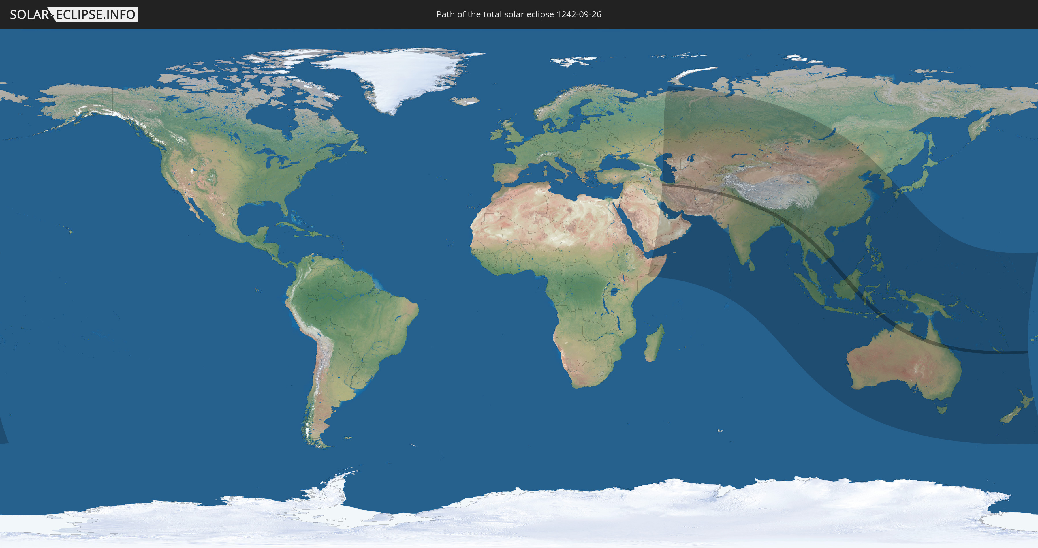
Die Sonnenfinsternis am 09/26/1242 kann man in 60 Ländern als partielle Sonnenfinsternis beobachten.
Der Finsternispfad verläuft durch 15 Länder. Nur in diesen Ländern ist sie als total Sonnenfinsternis zu sehen.
In den folgenden Ländern ist die Sonnenfinsternis total zu sehen
 Iran
Iran
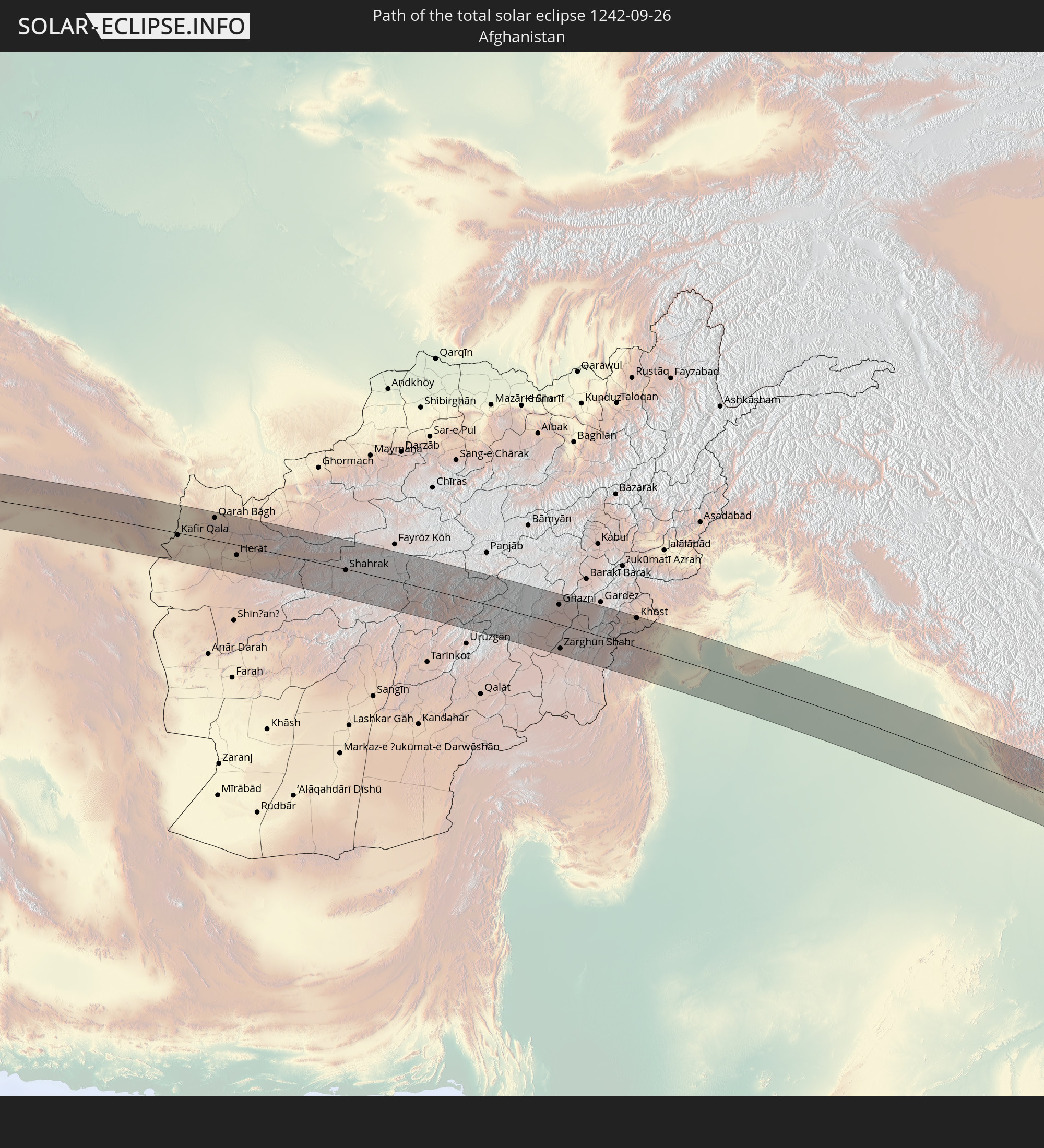 Afghanistan
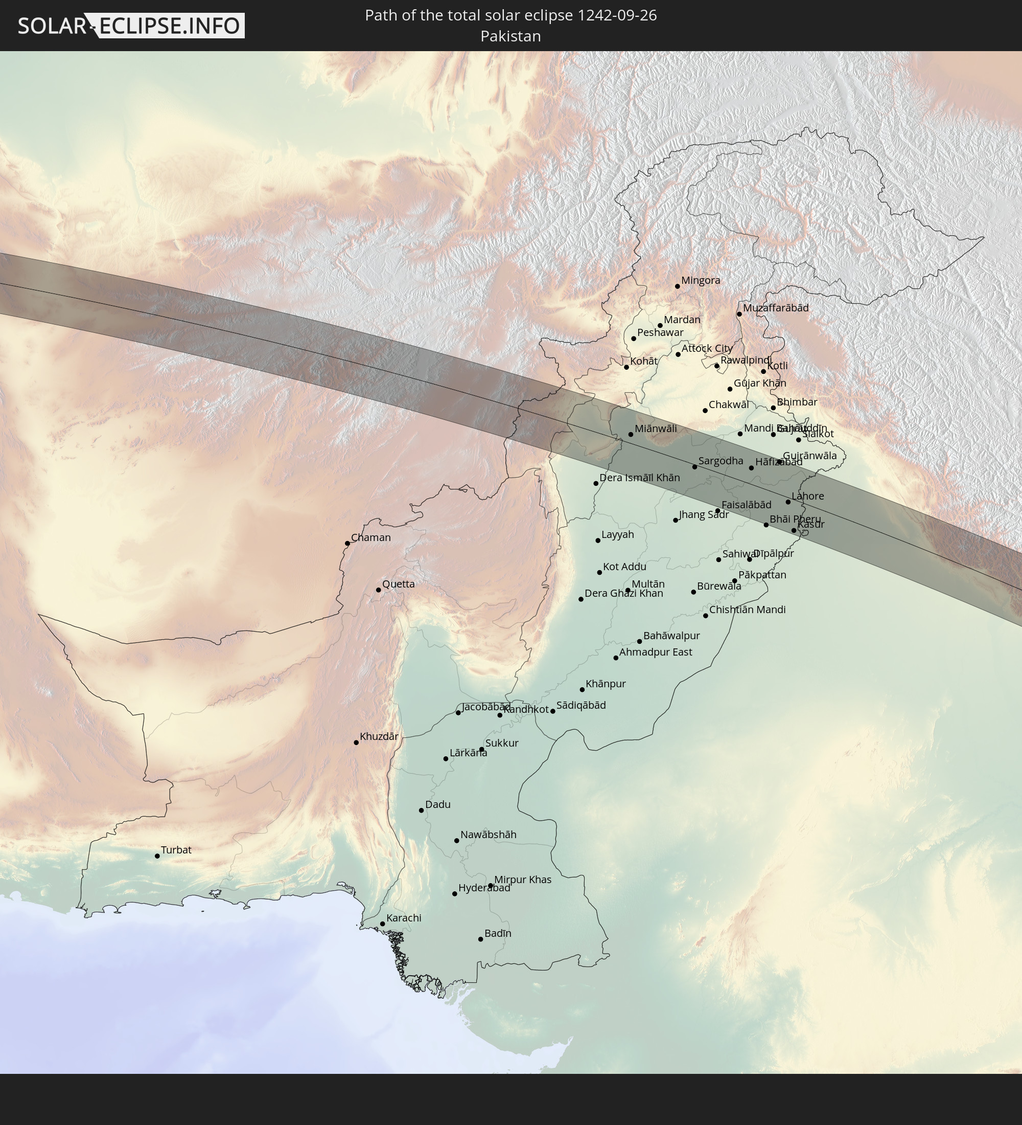 Pakistan
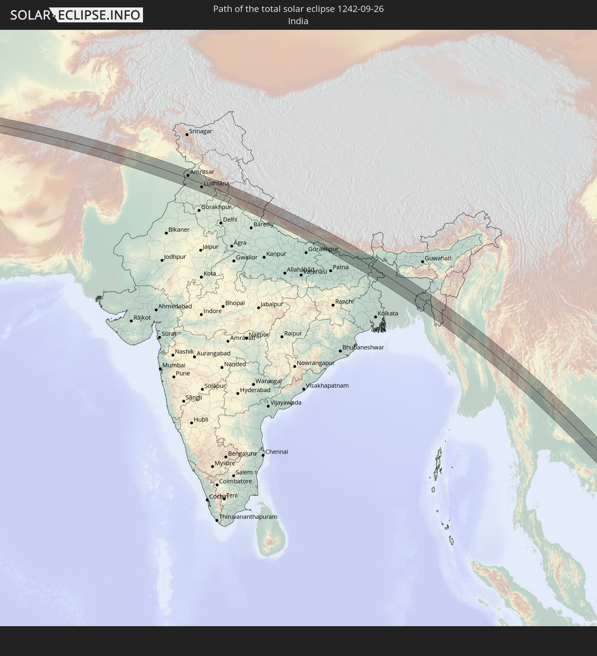 India
India
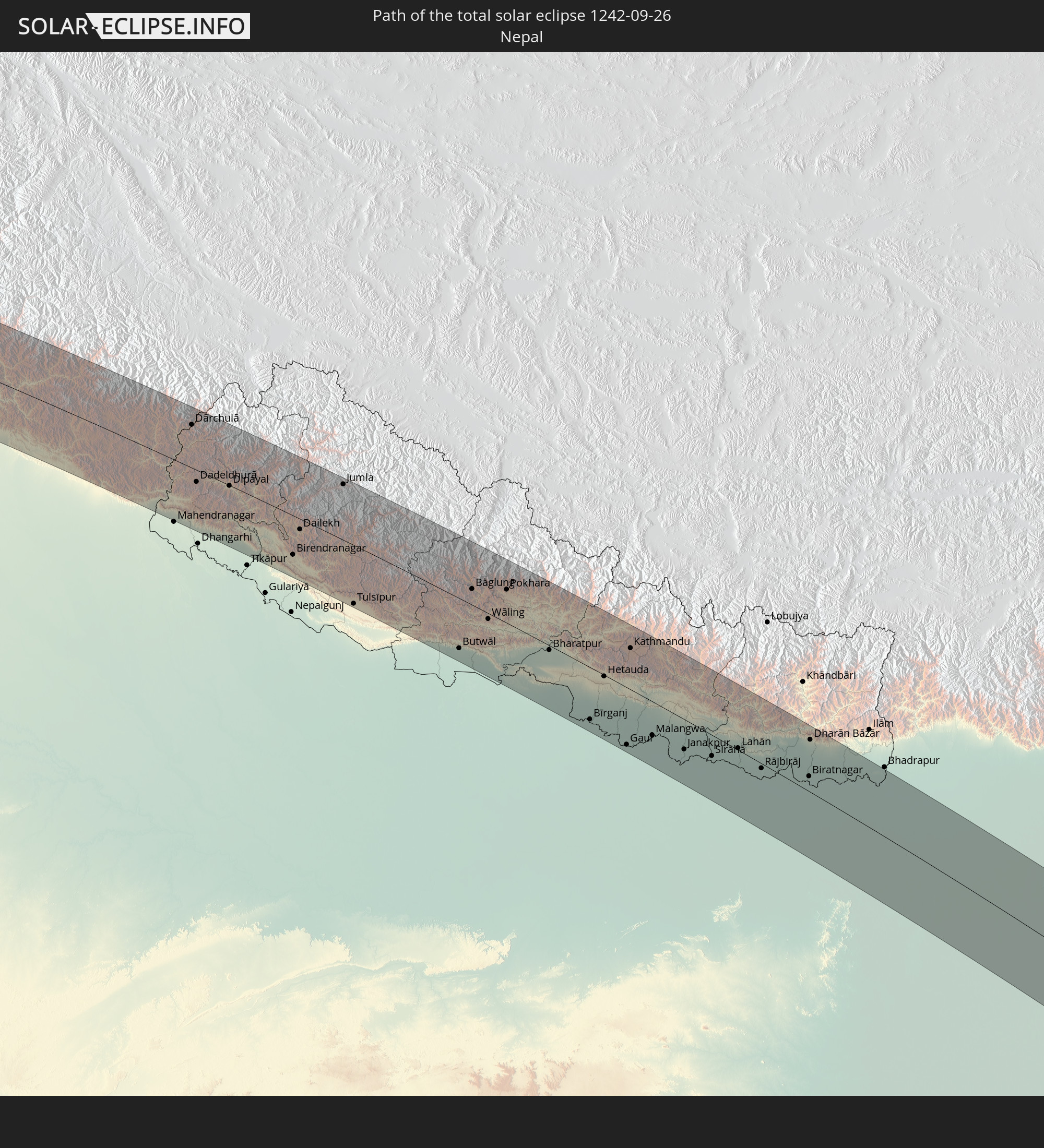 Nepal
Nepal
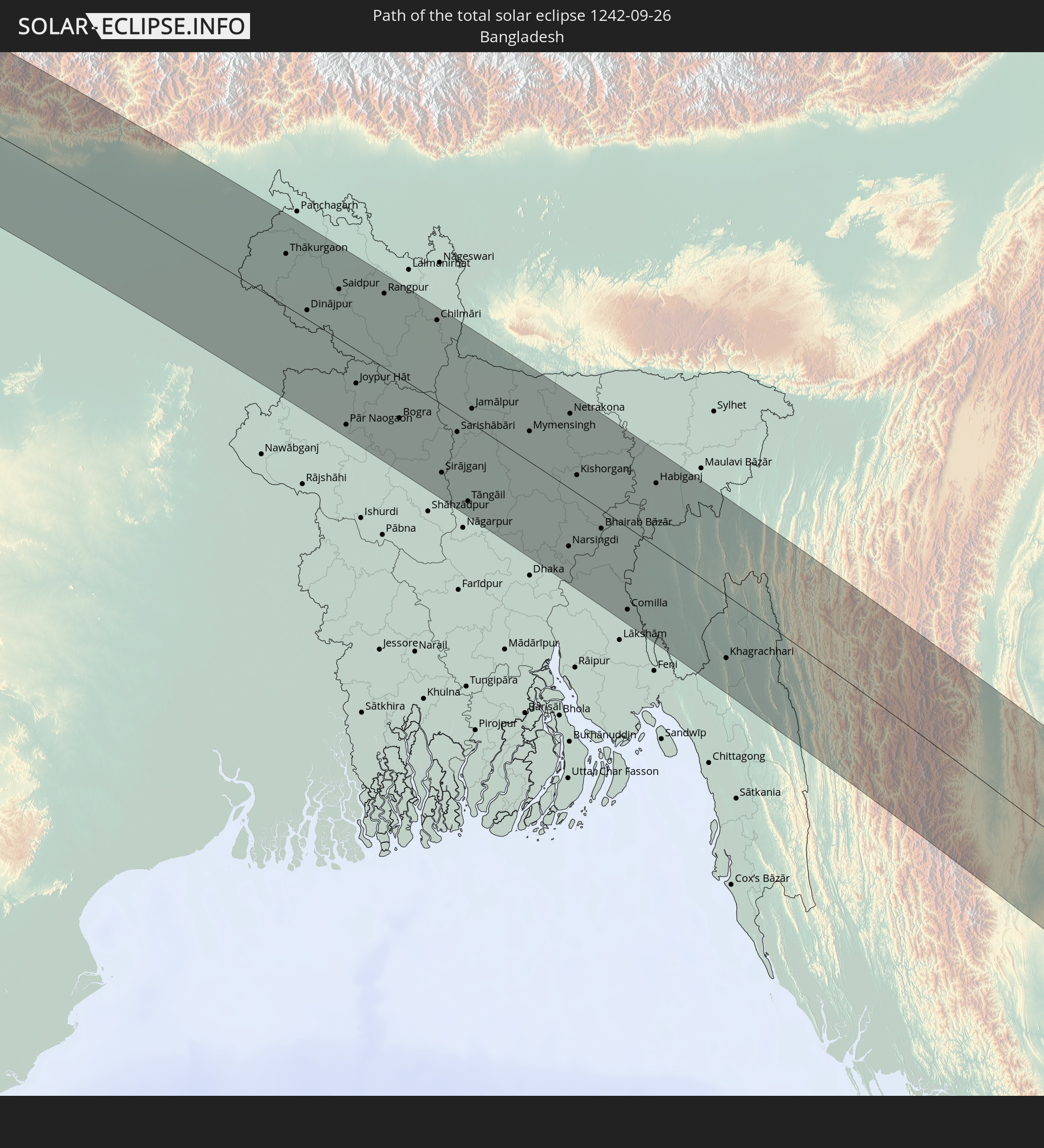 Bangladesh
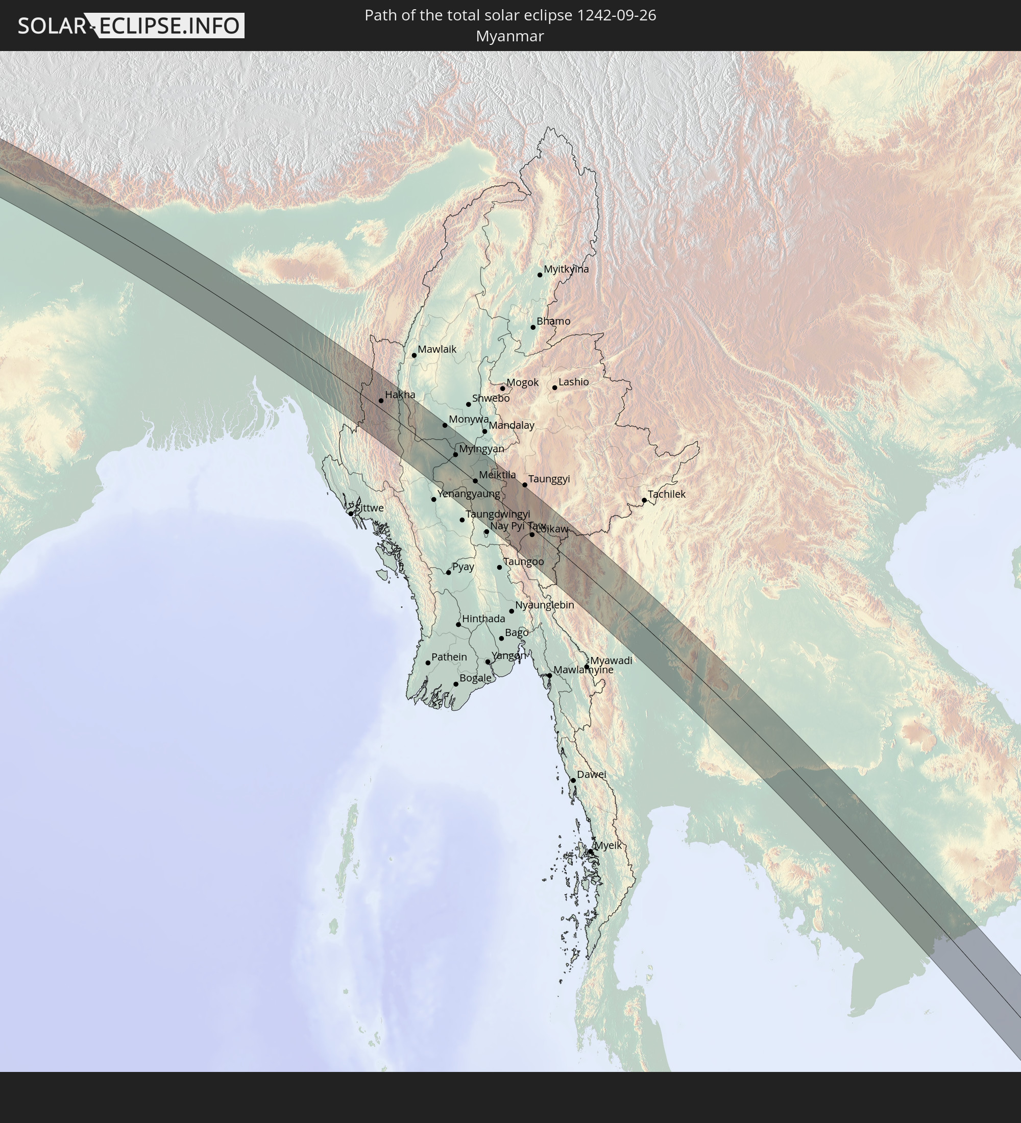 Myanmar
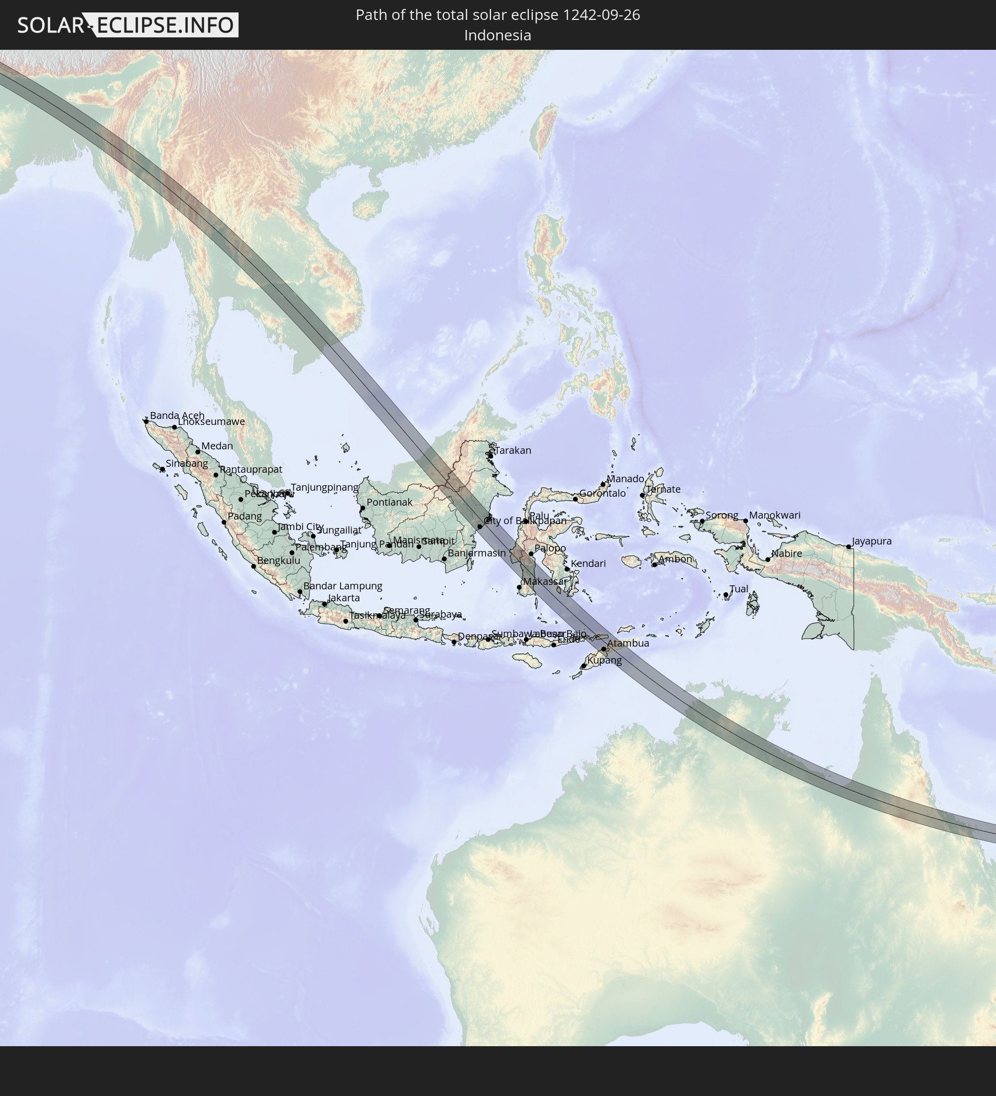 Indonesia
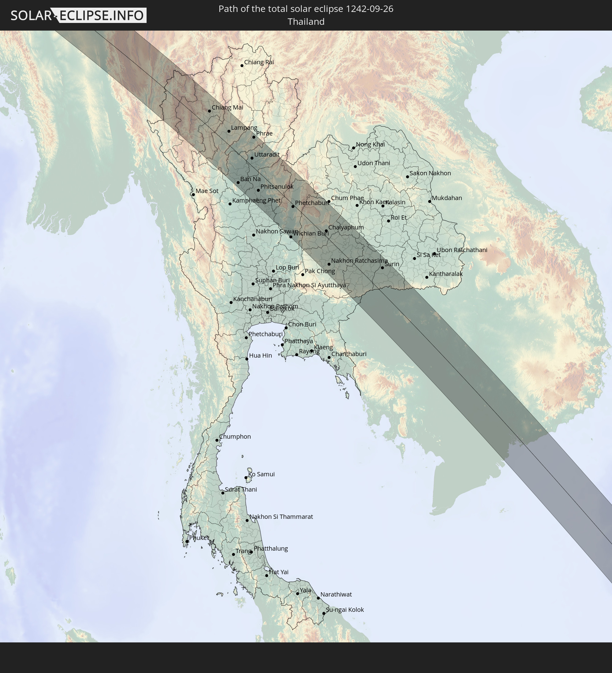 Thailand
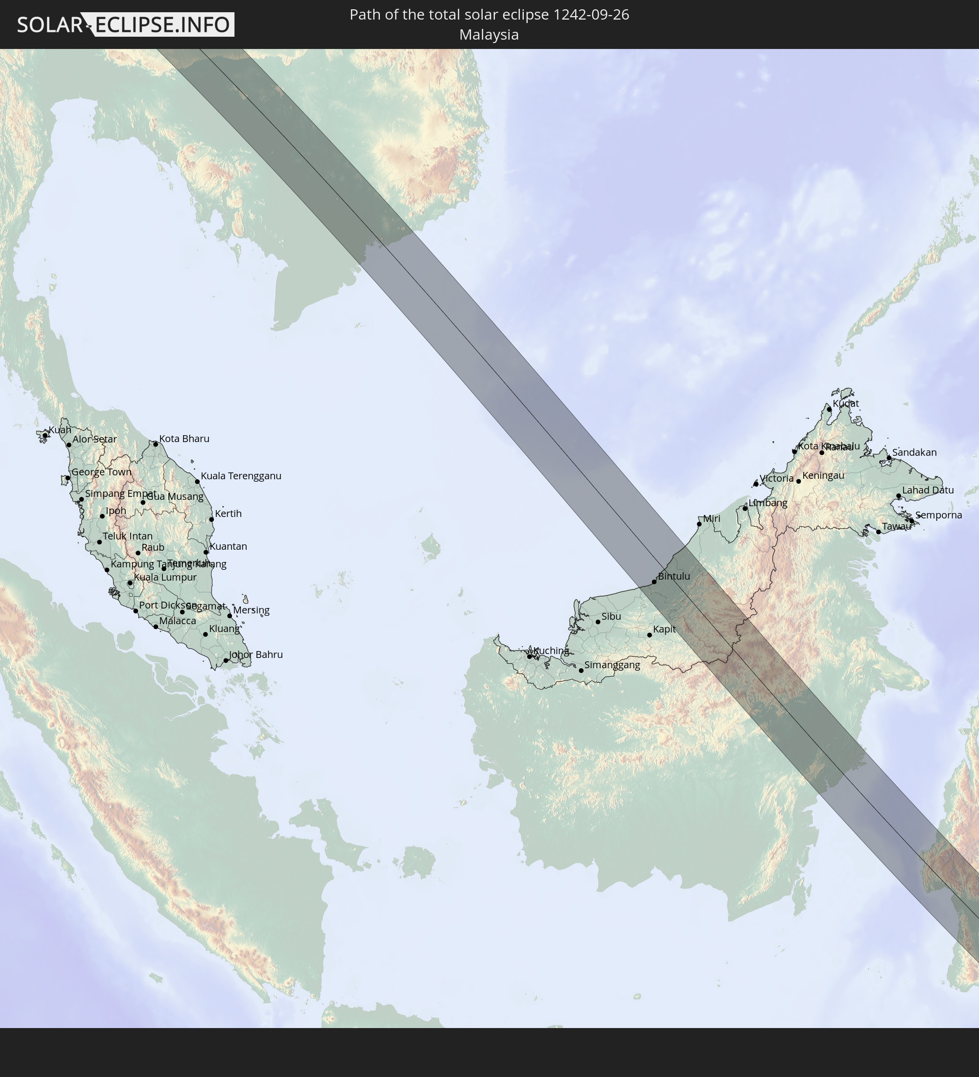 Malaysia
 Vietnam
 Cambodia
 Australia
 East Timor
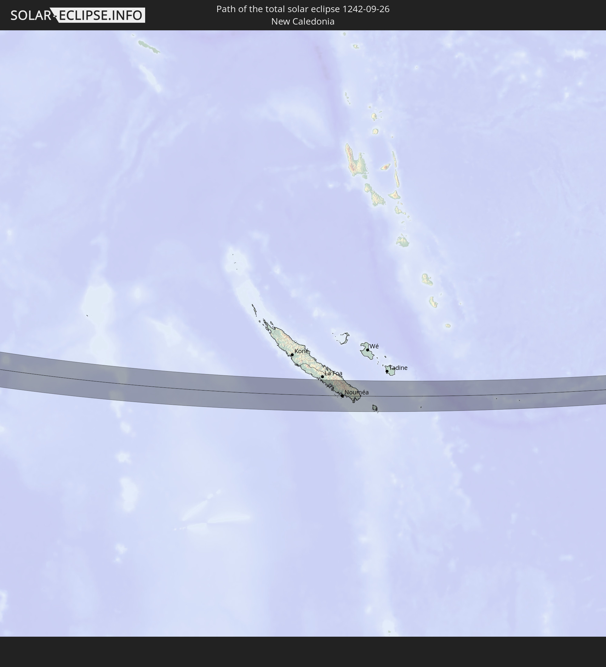 New Caledonia
In den folgenden Ländern ist die Sonnenfinsternis partiell zu sehen
 Russia
 New Zealand
 Kiribati
 Ethiopia
 Saudi Arabia
 Somalia
 Yemen
Yemen
 Iran
Iran
 Azerbaijan
 Kazakhstan
 Bahrain
 Qatar
Qatar
 United Arab Emirates
 Oman
Oman
 Turkmenistan
 Uzbekistan
 Afghanistan
 Pakistan
 Tajikistan
 India
India
 Kyrgyzstan
 Maldives
 China
China
 Sri Lanka
 Nepal
Nepal
 Mongolia
 Bangladesh
 Bhutan
 Myanmar
 Indonesia
 Cocos Islands
 Thailand
 Malaysia
 Laos
Laos
 Vietnam
 Cambodia
 Singapore
 Christmas Island
 Australia
 Macau
Macau
 Hong Kong
 Brunei
 Taiwan
 Philippines
 Japan
Japan
 East Timor
 North Korea
 South Korea
 Palau
Palau
 Federated States of Micronesia
 Papua New Guinea
 Guam
Guam
 Northern Mariana Islands
 Solomon Islands
 New Caledonia
 Marshall Islands
 Vanuatu
 Nauru
Nauru
 Norfolk Island
 Tuvalu
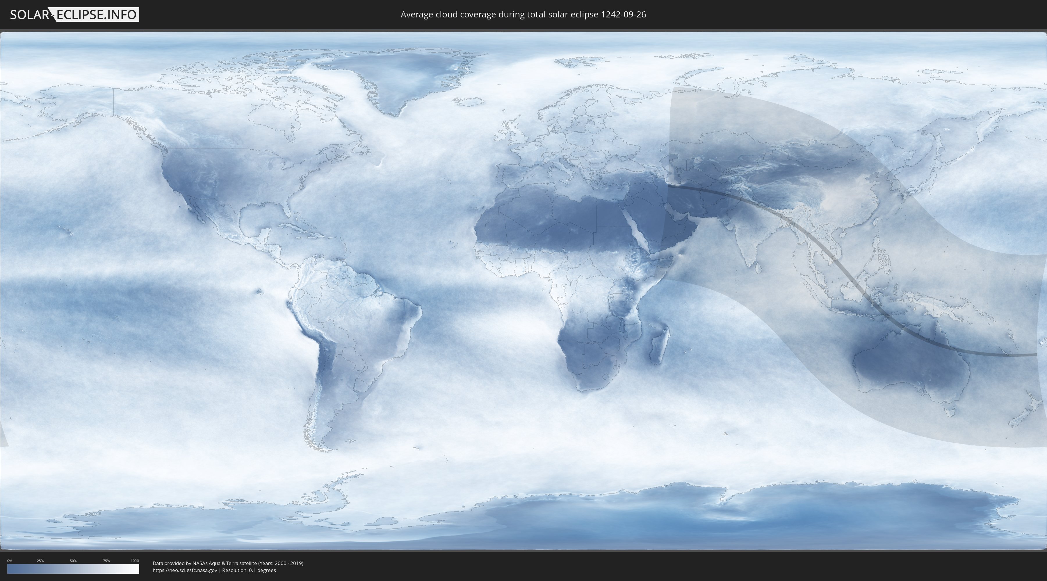
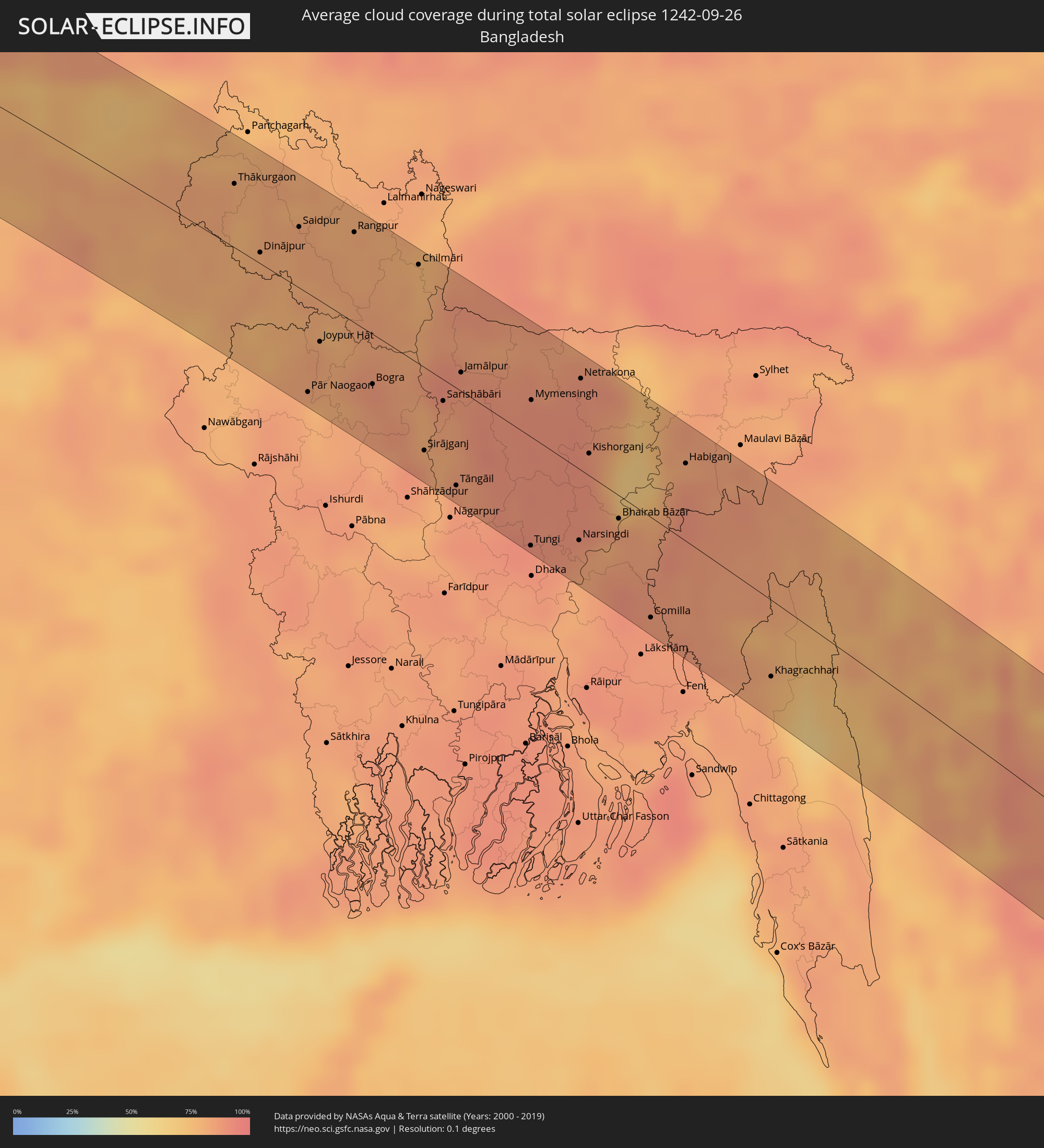
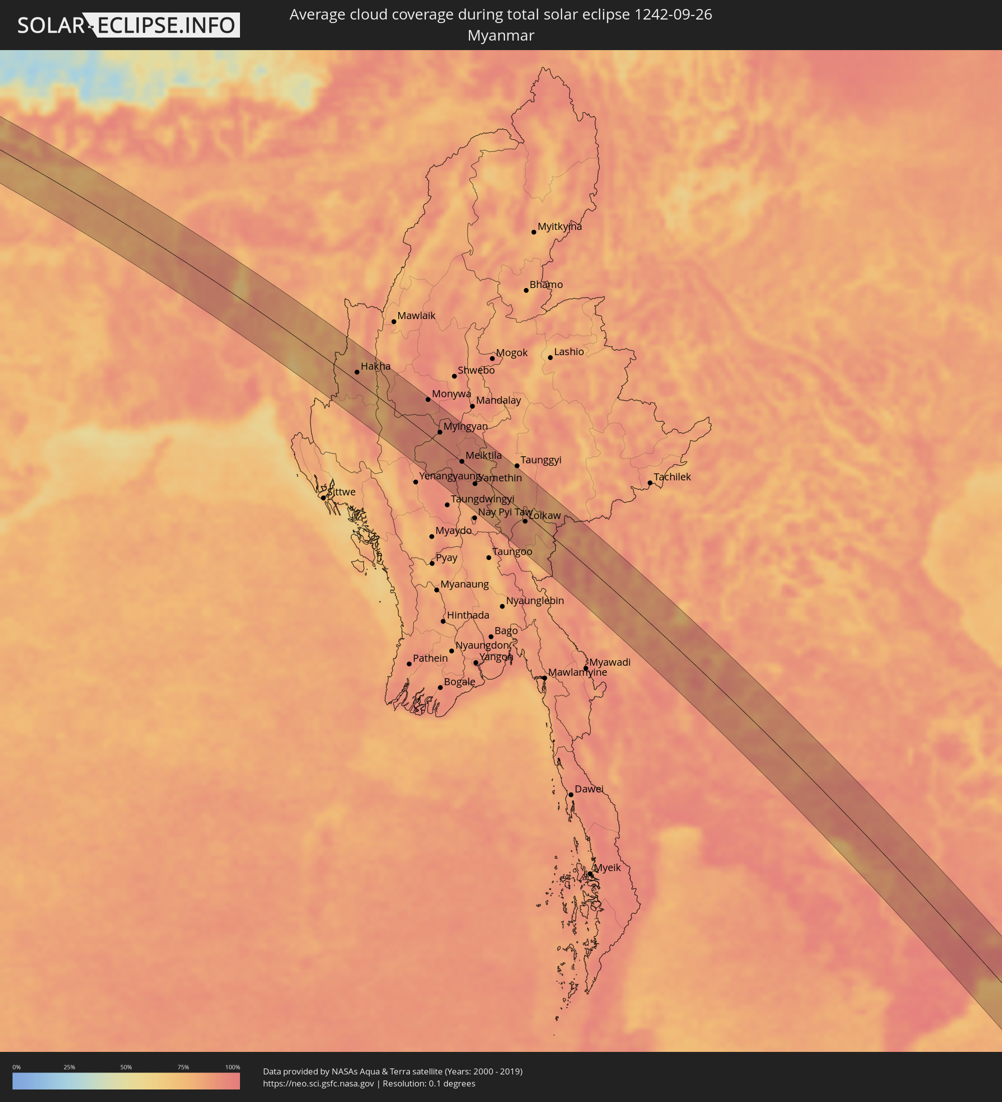
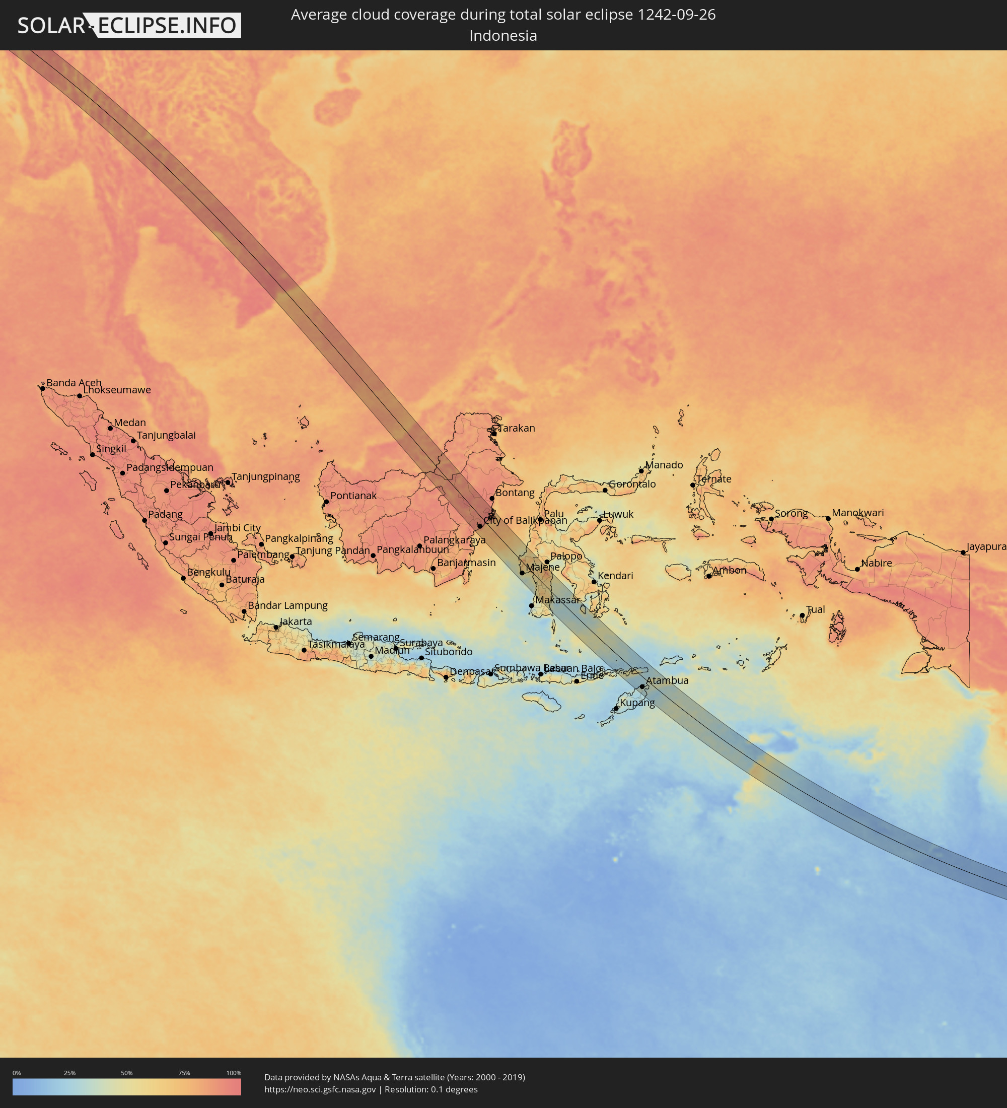
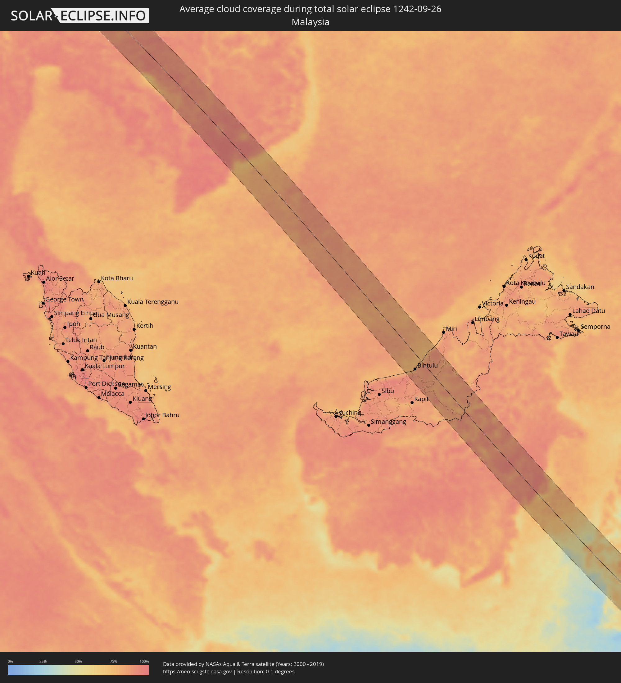
How will be the weather during the total solar eclipse on 09/26/1242?
Where is the best place to see the total solar eclipse of 09/26/1242?
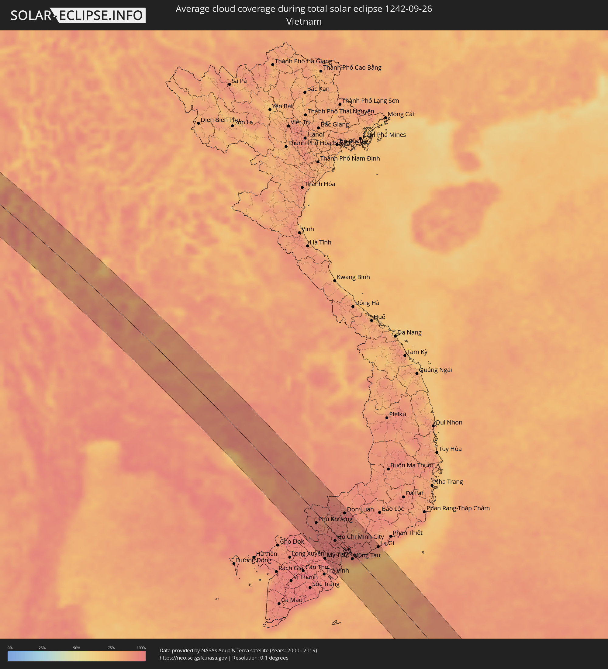
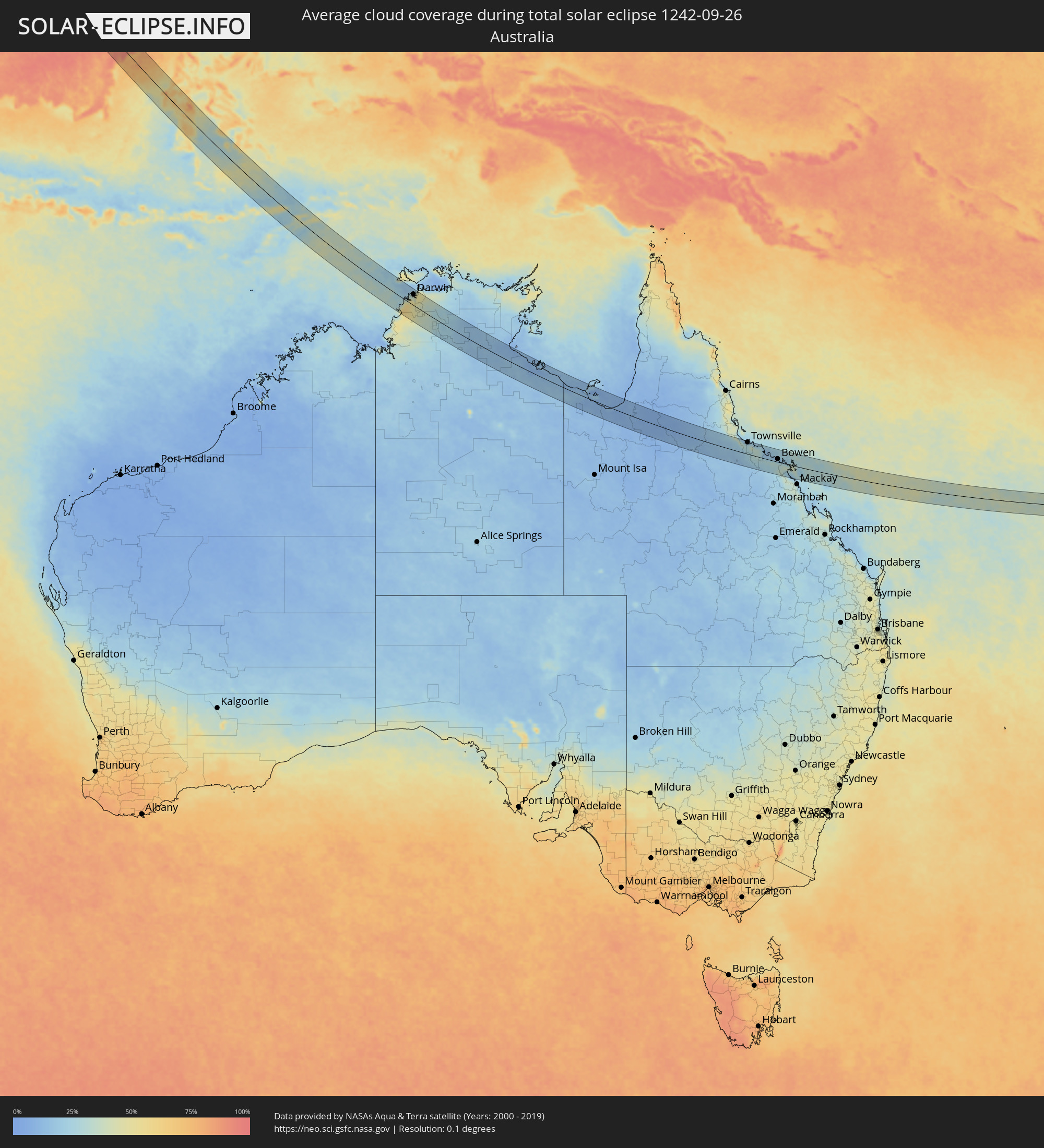
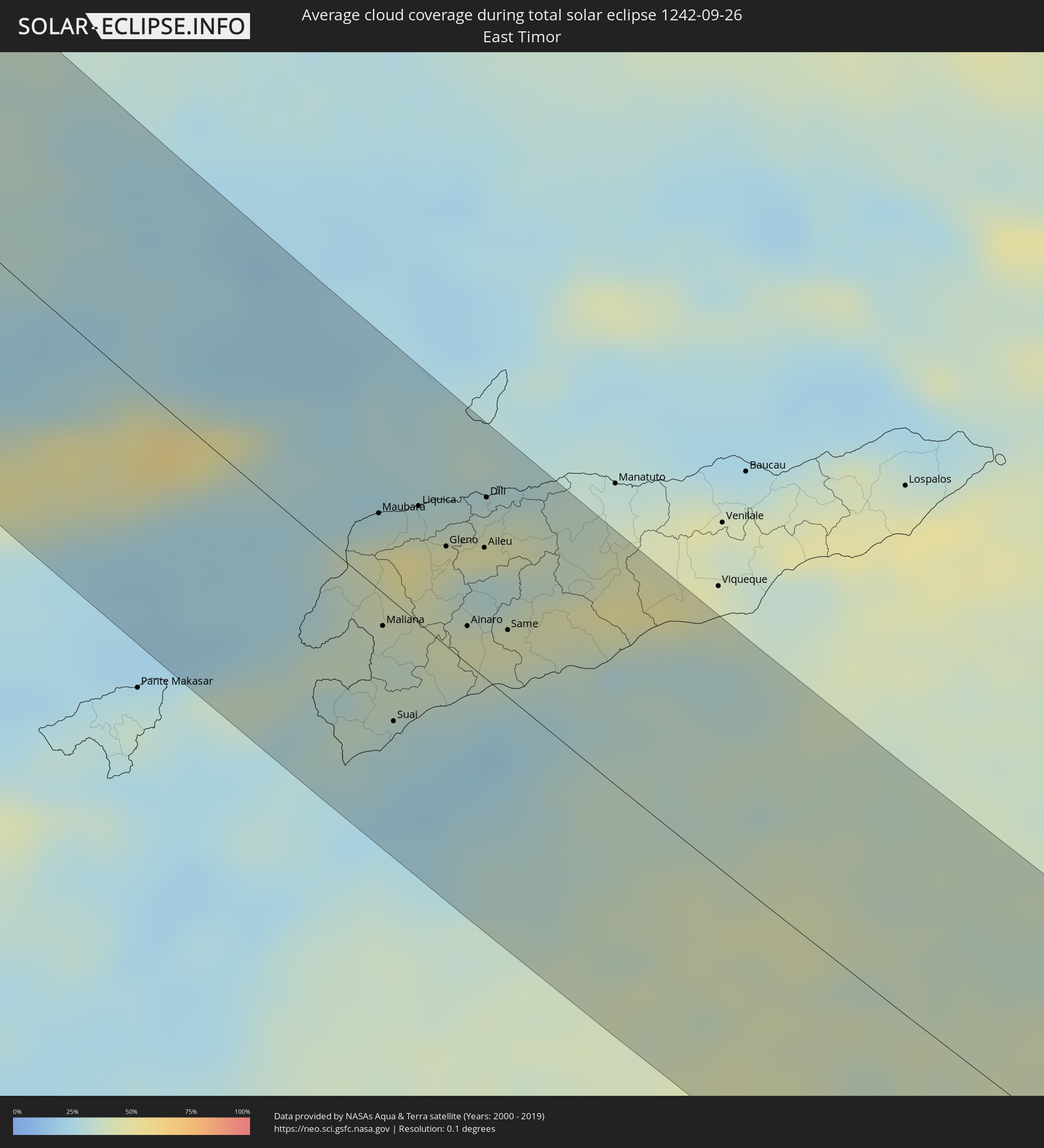
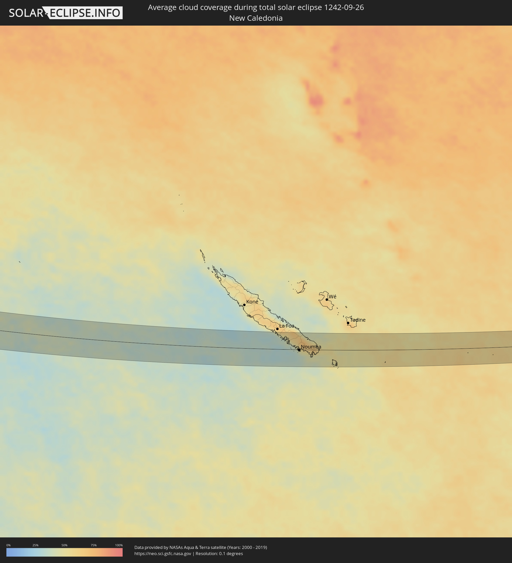
The following maps show the average cloud coverage for the day of the total solar eclipse.
With the help of these maps, it is possible to find the place along the eclipse path, which has the best
chance of a cloudless sky.
Nevertheless, you should consider local circumstances and inform about the weather of your chosen
observation site.
The data is provided by NASAs satellites
AQUA and TERRA.
The cloud maps are averaged over a period of 19 years (2000 - 2019).

Detailed country maps
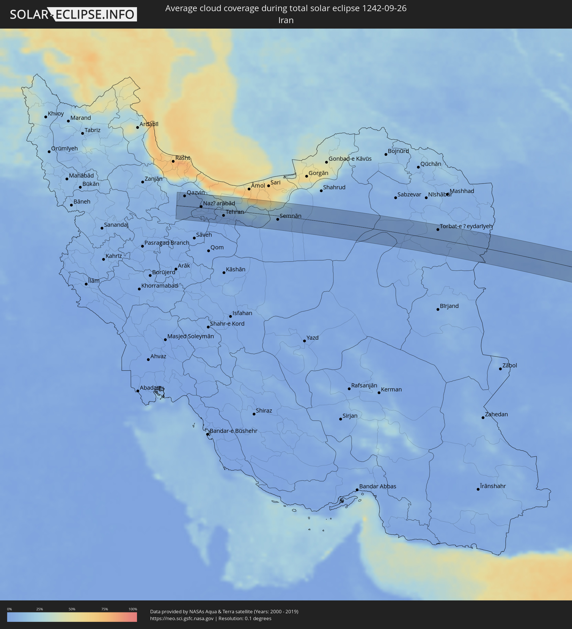 Iran
Iran
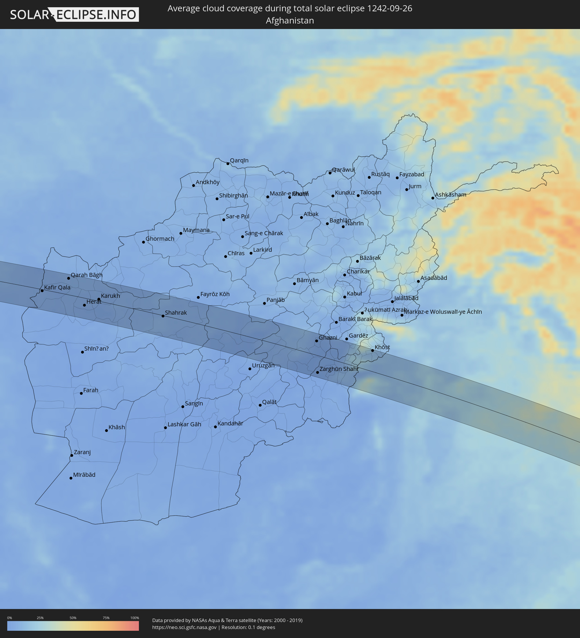 Afghanistan
 Pakistan
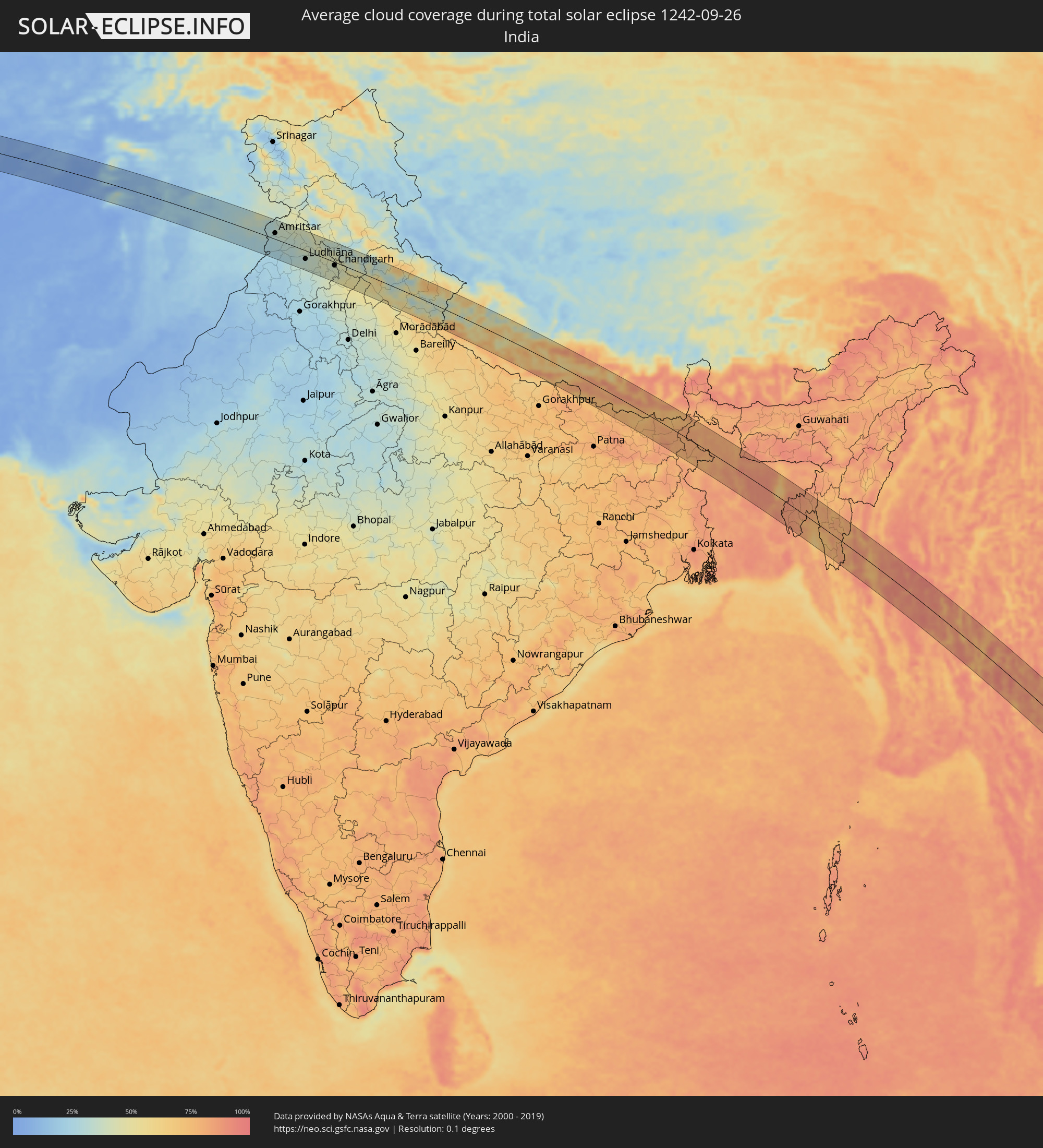 India
India
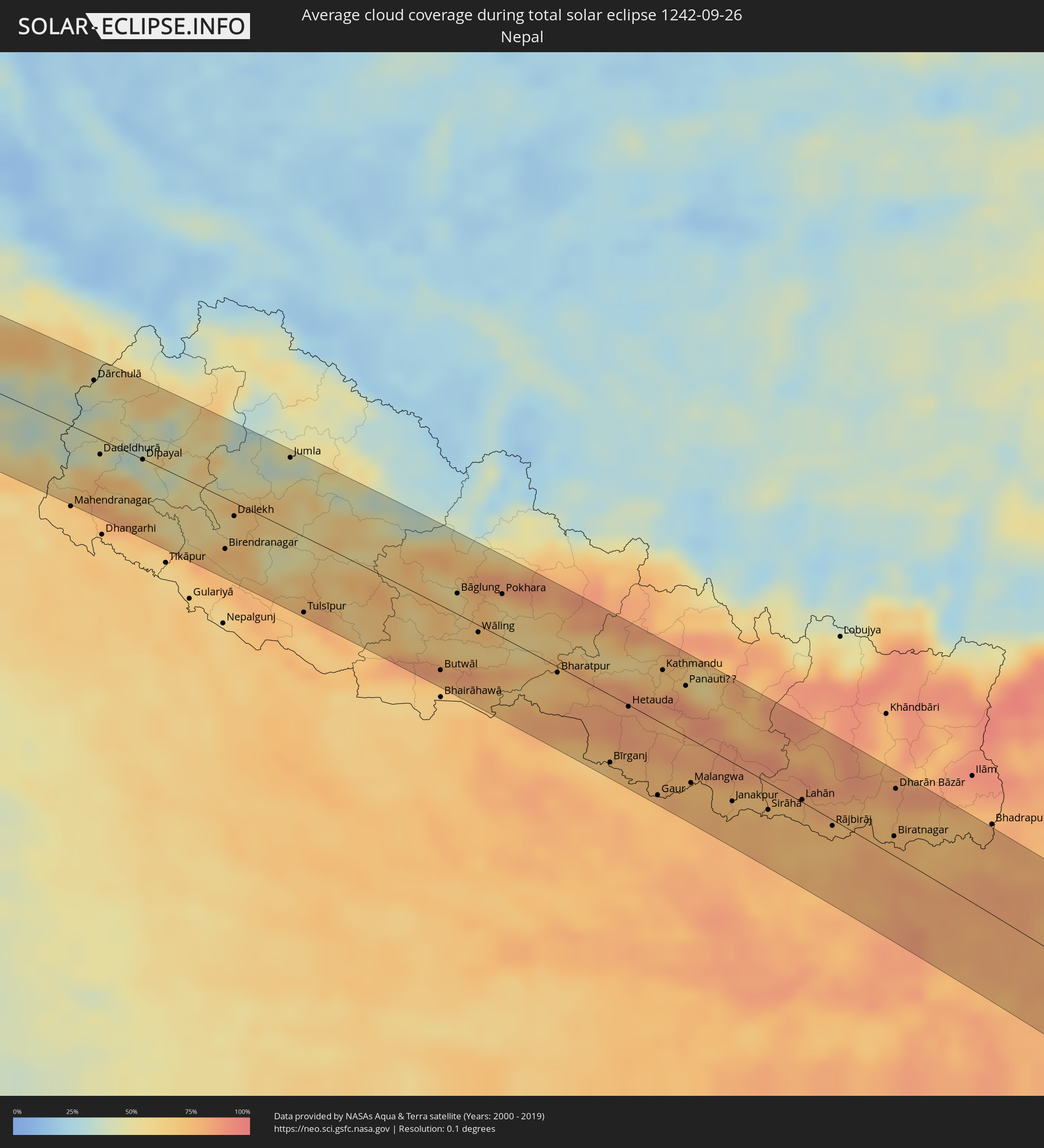 Nepal
Nepal
 Bangladesh
 Myanmar
 Indonesia
 Thailand
 Malaysia
 Vietnam
 Cambodia
 Australia
 East Timor
 New Caledonia
Cities inside the path of the eclipse
The following table shows all locations with a population of more than 5,000 inside the eclipse path. Cities which have more than 100,000 inhabitants are marked bold. A click at the locations opens a detailed map.
| City | Type | Eclipse duration | Local time of max. eclipse | Distance to central line | Ø Cloud coverage |
|
Qazvin, Qazvīn
|
total | - | 06:07:31 UTC+03:25 | 33 km | 6% |
|
Ābyek, Markazi
|
total | - | 06:07:30 UTC+03:25 | 15 km | 4% |
|
Naz̧arābād, Alborz
|
total | - | 06:07:29 UTC+03:25 | 3 km | 4% |
|
Malārd, Tehrān
|
total | - | 06:07:27 UTC+03:25 | 26 km | 2% |
|
Karaj, Alborz
|
total | - | 06:07:29 UTC+03:25 | 7 km | 2% |
|
Shahre Jadide Andisheh, Tehrān
|
total | - | 06:07:27 UTC+03:25 | 24 km | 2% |
|
Shahrīār, Tehrān
|
total | - | 06:07:27 UTC+03:25 | 26 km | 2% |
|
Tehran, Tehrān
|
total | - | 06:07:29 UTC+03:25 | 19 km | 2% |
|
Damāvand, Tehrān
|
total | - | 06:07:31 UTC+03:25 | 10 km | 7% |
|
Mahdishahr, Semnān
|
total | - | 06:07:37 UTC+03:25 | 2 km | 7% |
|
Semnān, Semnān
|
total | - | 06:07:36 UTC+03:25 | 12 km | 4% |
|
Kāshmar, Razavi Khorasan
|
total | - | 06:08:21 UTC+03:25 | 16 km | 4% |
|
Torbat-e Ḩeydarīyeh, Razavi Khorasan
|
total | - | 06:08:32 UTC+03:25 | 32 km | 5% |
|
Tāybād, Razavi Khorasan
|
total | - | 06:08:53 UTC+03:25 | 1 km | 4% |
|
Kafir Qala, Herat
|
total | - | 06:43:14 UTC+04:00 | 4 km | 4% |
|
Kuhsān, Herat
|
total | - | 06:43:16 UTC+04:00 | 3 km | 4% |
|
Tīr Pul, Herat
|
total | - | 06:43:17 UTC+04:00 | 8 km | 3% |
|
Zindah Jān, Herat
|
total | - | 06:43:25 UTC+04:00 | 27 km | 2% |
|
Qarah Bāgh, Herat
|
total | - | 06:43:27 UTC+04:00 | 39 km | 4% |
|
Chahār Burj, Herat
|
total | - | 06:43:34 UTC+04:00 | 29 km | 2% |
|
Herāt, Herat
|
total | - | 06:43:34 UTC+04:00 | 18 km | 2% |
|
Karukh, Herat
|
total | - | 06:43:41 UTC+04:00 | 4 km | 2% |
|
Shahrak, Ghowr
|
total | - | 06:44:17 UTC+04:00 | 2 km | 7% |
|
Ghazni, Ghazni
|
total | - | 06:46:03 UTC+04:00 | 34 km | 2% |
|
Zarghūn Shahr, Paktika
|
total | - | 06:46:09 UTC+04:00 | 41 km | 1% |
|
Sharan, Paktika
|
total | - | 06:46:15 UTC+04:00 | 1 km | 2% |
|
Zaṟah Sharan, Paktika
|
total | - | 06:46:17 UTC+04:00 | 1 km | 1% |
|
Khōst, Khowst
|
total | - | 06:46:50 UTC+04:00 | 50 km | 13% |
|
Miānwāli, Punjab
|
total | - | 07:16:01 UTC+04:28 | 13 km | 21% |
|
Khushāb, Punjab
|
total | - | 07:16:33 UTC+04:28 | 8 km | 21% |
|
Sargodha, Punjab
|
total | - | 07:16:48 UTC+04:28 | 4 km | 25% |
|
Bhalwāl, Punjab
|
total | - | 07:16:54 UTC+04:28 | 23 km | 25% |
|
Chiniot, Punjab
|
total | - | 07:17:04 UTC+04:28 | 33 km | 27% |
|
Shahkot, Punjab
|
total | - | 07:17:26 UTC+04:28 | 33 km | 24% |
|
Hāfizābād, Punjab
|
total | - | 07:17:26 UTC+04:28 | 25 km | 30% |
|
Chūhar Kāna, Punjab
|
total | - | 07:17:35 UTC+04:28 | 4 km | 28% |
|
Sheikhupura, Punjab
|
total | - | 07:17:42 UTC+04:28 | 3 km | 31% |
|
Gujrānwāla, Punjab
|
total | - | 07:17:44 UTC+04:28 | 51 km | 35% |
|
Kamoke, Punjab
|
total | - | 07:17:48 UTC+04:28 | 33 km | 34% |
|
Murīdke, Punjab
|
total | - | 07:17:52 UTC+04:28 | 16 km | 32% |
|
Lahore, Punjab
|
total | - | 07:17:59 UTC+04:28 | 8 km | 27% |
|
Kasūr, Punjab
|
total | - | 07:18:11 UTC+04:28 | 50 km | 26% |
|
Amritsar, Punjab
|
total | - | 08:11:17 UTC+05:21 | 17 km | 32% |
|
Jalandhar, Punjab
|
total | - | 08:11:52 UTC+05:21 | 10 km | 34% |
|
Ludhiāna, Punjab
|
total | - | 08:12:11 UTC+05:21 | 24 km | 34% |
|
Chandigarh, Chandigarh
|
total | - | 08:12:55 UTC+05:21 | 9 km | 41% |
|
Ambāla, Haryana
|
total | - | 08:13:04 UTC+05:21 | 48 km | 43% |
|
Shimla, Himachal Pradesh
|
total | - | 08:13:04 UTC+05:21 | 42 km | 42% |
|
Yamunānagar, Haryana
|
total | - | 08:13:32 UTC+05:21 | 54 km | 50% |
|
Dehra Dūn, Uttarakhand
|
total | - | 08:14:02 UTC+05:21 | 6 km | 54% |
|
Haridwar, Uttarakhand
|
total | - | 08:14:17 UTC+05:21 | 40 km | 48% |
|
Birendranagar, Mid Western
|
total | - | 08:37:59 UTC+05:41 | 38 km | 69% |
|
Tulsīpur, Mid Western
|
total | - | 08:38:51 UTC+05:41 | 56 km | 64% |
|
Butwāl, Western Region
|
total | - | 08:40:13 UTC+05:41 | 48 km | 74% |
|
Pokhara, Western Region
|
total | - | 08:40:22 UTC+05:41 | 32 km | 67% |
|
Bharatpur, Central Region
|
total | - | 08:41:12 UTC+05:41 | 4 km | 66% |
|
Bīrganj, Central Region
|
total | - | 08:42:06 UTC+05:41 | 49 km | 72% |
|
Hetauda, Central Region
|
total | - | 08:41:58 UTC+05:41 | 1 km | 85% |
|
Kathmandu, Central Region
|
total | - | 08:42:04 UTC+05:41 | 39 km | 70% |
|
Janakpur, Central Region
|
total | - | 08:43:23 UTC+05:41 | 28 km | 74% |
|
Lahān, Eastern Region
|
total | - | 08:44:00 UTC+05:41 | 2 km | 75% |
|
Rājbirāj, Eastern Region
|
total | - | 08:44:25 UTC+05:41 | 5 km | 71% |
|
Biratnagar, Eastern Region
|
total | - | 08:45:02 UTC+05:41 | 14 km | 76% |
|
Ithari, Eastern Region
|
total | - | 08:44:53 UTC+05:41 | 35 km | 76% |
|
Dharān Bāzār, Eastern Region
|
total | - | 08:44:46 UTC+05:41 | 49 km | 83% |
|
Purnia, Bihar
|
total | - | 08:25:43 UTC+05:21 | 40 km | 86% |
|
Katihar, Bihar
|
total | - | 08:26:01 UTC+05:21 | 58 km | 77% |
|
Rāiganj, West Bengal
|
total | - | 08:26:35 UTC+05:21 | 22 km | 80% |
|
Dinājpur, Rangpur Division
|
total | - | 08:59:19 UTC+05:53 | 6 km | 82% |
|
Saidpur, Rājshāhi
|
total | - | 08:59:29 UTC+05:53 | 34 km | 83% |
|
Pār Naogaon, Rājshāhi
|
total | - | 09:00:24 UTC+05:53 | 55 km | 82% |
|
Rangpur, Rangpur Division
|
total | - | 08:59:55 UTC+05:53 | 50 km | 80% |
|
Bogra, Rājshāhi
|
total | - | 09:00:52 UTC+05:53 | 28 km | 88% |
|
Sirājganj, Rājshāhi
|
total | - | 09:01:38 UTC+05:53 | 46 km | 87% |
|
Tāngāil, Dhaka
|
total | - | 09:02:04 UTC+05:53 | 54 km | 87% |
|
Jamālpur, Dhaka
|
total | - | 09:01:29 UTC+05:53 | 10 km | 89% |
|
Tungi, Dhaka
|
total | - | 09:03:01 UTC+05:53 | 60 km | 91% |
|
Mymensingh, Dhaka
|
total | - | 09:02:11 UTC+05:53 | 20 km | 90% |
|
Narsingdi, Dhaka
|
total | - | 09:03:22 UTC+05:53 | 39 km | 86% |
|
Kishorganj, Dhaka
|
total | - | 09:02:56 UTC+05:53 | 12 km | 89% |
|
Bhairab Bāzār, Dhaka
|
total | - | 09:03:33 UTC+05:53 | 13 km | 84% |
|
Comilla, Chittagong
|
total | - | 09:04:25 UTC+05:53 | 55 km | 89% |
|
Agartala, Tripura
|
total | - | 08:31:59 UTC+05:21 | 15 km | 88% |
|
Aizawl, Mizoram
|
total | - | 08:33:54 UTC+05:21 | 59 km | 78% |
|
Hakha, Chin
|
total | - | 09:39:52 UTC+06:24 | 16 km | 88% |
|
Falam, Chin
|
total | - | 09:39:39 UTC+06:24 | 43 km | 80% |
|
Chauk, Magway
|
total | - | 09:43:35 UTC+06:24 | 65 km | 85% |
|
Pakokku, Magway
|
total | - | 09:43:24 UTC+06:24 | 9 km | 88% |
|
Monywa, Sagain
|
total | - | 09:42:32 UTC+06:24 | 62 km | 90% |
|
Myingyan, Mandalay
|
total | - | 09:43:40 UTC+06:24 | 21 km | 89% |
|
Meiktila, Mandalay
|
total | - | 09:45:03 UTC+06:24 | 1 km | 87% |
|
Yamethin, Mandalay
|
total | - | 09:46:02 UTC+06:24 | 20 km | 91% |
|
Loikaw, Kayah
|
total | - | 09:48:35 UTC+06:24 | 13 km | 82% |
|
Chiang Mai, Chiang Mai
|
total | - | 10:09:44 UTC+06:42 | 34 km | 90% |
|
Lamphun, Lamphun
|
total | - | 10:10:05 UTC+06:42 | 18 km | 87% |
|
San Kamphaeng, Chiang Mai
|
total | - | 10:10:00 UTC+06:42 | 39 km | 86% |
|
Lampang, Lampang
|
total | - | 10:11:14 UTC+06:42 | 28 km | 87% |
|
Ban Na, Sukhothai
|
total | - | 10:13:33 UTC+06:42 | 60 km | 87% |
|
Uttaradit, Uttaradit
|
total | - | 10:13:10 UTC+06:42 | 16 km | 83% |
|
Phrae, Phrae
|
total | - | 10:12:27 UTC+06:42 | 62 km | 84% |
|
Phitsanulok, Phitsanulok
|
total | - | 10:14:40 UTC+06:42 | 38 km | 92% |
|
Phichit, Phichit
|
total | - | 10:15:25 UTC+06:42 | 62 km | 90% |
|
Wichian Buri, Phetchabun
|
total | - | 10:17:53 UTC+06:42 | 70 km | 87% |
|
Phetchabun, Phetchabun
|
total | - | 10:16:44 UTC+06:42 | 4 km | 84% |
|
Chaiyaphum, Chaiyaphum
|
total | - | 10:19:07 UTC+06:42 | 11 km | 82% |
|
Nakhon Ratchasima, Nakhon Ratchasima
|
total | - | 10:20:38 UTC+06:42 | 50 km | 92% |
|
Surin, Surin
|
total | - | 10:23:04 UTC+06:42 | 49 km | 88% |
|
Sâmraông, Ŏtâr Méanchey
|
total | - | 10:24:19 UTC+06:42 | 4 km | 90% |
|
Siem Reap, Siem Reap
|
total | - | 10:26:20 UTC+06:42 | 40 km | 92% |
|
Kampong Chhnang, Kampong Chhnang
|
total | - | 10:29:43 UTC+06:42 | 63 km | 85% |
|
Kampong Thom, Kampong Thom
|
total | - | 10:29:15 UTC+06:42 | 10 km | 90% |
|
Prey Veng, Prey Veng
|
total | - | 10:32:16 UTC+06:42 | 68 km | 84% |
|
Kampong Cham, Kampong Cham
|
total | - | 10:31:34 UTC+06:42 | 19 km | 89% |
|
Suŏng, Tboung Khmum
|
total | - | 10:32:03 UTC+06:42 | 9 km | 89% |
|
Svay Rieng, Svay Rieng
|
total | - | 10:33:51 UTC+06:42 | 60 km | 94% |
|
Kratié, Kratie
|
total | - | 10:31:36 UTC+06:42 | 63 km | 85% |
|
Tây Ninh, Tây Ninh
|
total | - | 10:58:32 UTC+07:06 | 19 km | 95% |
|
Phú Khương, Tây Ninh
|
total | - | 10:58:39 UTC+07:06 | 19 km | 95% |
|
Mỹ Tho, Tiền Giang
|
total | - | 11:00:49 UTC+07:06 | 69 km | 96% |
|
Tân An, Long An
|
total | - | 11:00:34 UTC+07:06 | 52 km | 95% |
|
Củ Chi, Ho Chi Minh City
|
total | - | 10:59:52 UTC+07:06 | 13 km | 97% |
|
Bình Long, Bình Phước
|
total | - | 10:58:47 UTC+07:06 | 47 km | 93% |
|
Ho Chi Minh City, Ho Chi Minh City
|
total | - | 11:00:24 UTC+07:06 | 13 km | 97% |
|
Thủ Dầu Một, Bình Dương
|
total | - | 11:00:08 UTC+07:06 | 1 km | 96% |
|
Cần Giuộc, Long An
|
total | - | 11:00:53 UTC+07:06 | 26 km | 94% |
|
Biên Hòa, Đồng Nai
|
total | - | 11:00:30 UTC+07:06 | 12 km | 96% |
|
Don Luan, Bình Phước
|
total | - | 10:59:29 UTC+07:06 | 61 km | 94% |
|
Cần Giờ, Ho Chi Minh City
|
total | - | 11:01:46 UTC+07:06 | 17 km | 80% |
|
Vũng Tàu, Bà Rịa-Vũng Tàu
|
total | - | 11:02:07 UTC+07:06 | 12 km | 73% |
|
La Gi, Bình Thuận
|
total | - | 11:02:43 UTC+07:06 | 68 km | 82% |
|
Bintulu, Sarawak
|
total | - | 11:42:21 UTC+07:21 | 38 km | 81% |
|
Balikpapan, East Kalimantan
|
total | - | 12:35:11 UTC+07:57 | 45 km | 74% |
|
City of Balikpapan, East Kalimantan
|
total | - | 12:35:15 UTC+07:57 | 38 km | 84% |
|
Loa Janan, East Kalimantan
|
total | - | 12:34:14 UTC+07:57 | 28 km | 94% |
|
Samarinda, East Kalimantan
|
total | - | 12:34:08 UTC+07:57 | 39 km | 95% |
|
Mamuju, West Sulawesi
|
total | - | 12:42:01 UTC+07:57 | 16 km | 75% |
|
Majene, West Sulawesi
|
total | - | 12:43:57 UTC+07:57 | 43 km | 48% |
|
Polewali, West Sulawesi
|
total | - | 12:44:26 UTC+07:57 | 5 km | 56% |
|
Parepare, South Sulawesi
|
total | - | 12:46:09 UTC+07:57 | 27 km | 53% |
|
Sengkang, South Sulawesi
|
total | - | 12:47:09 UTC+07:57 | 4 km | 56% |
|
Sinjai, South Sulawesi
|
total | - | 12:49:35 UTC+07:57 | 64 km | 40% |
|
Watampone, South Sulawesi
|
total | - | 12:48:32 UTC+07:57 | 12 km | 59% |
|
Atambua, East Nusa Tenggara
|
total | - | 13:05:43 UTC+07:57 | 42 km | 35% |
|
Maubara, Liquiçá
|
total | - | 13:30:07 UTC+08:22 | 22 km | 43% |
|
Maliana, Bobonaro
|
total | - | 13:30:49 UTC+08:22 | 10 km | 36% |
|
Suai, Cova Lima
|
total | - | 13:31:28 UTC+08:22 | 34 km | 29% |
|
Liquica, Liquiçá
|
total | - | 13:30:19 UTC+08:22 | 34 km | 50% |
|
Gleno, Ermera District
|
total | - | 13:30:44 UTC+08:22 | 29 km | 43% |
|
Ainaro, Ainaro
|
total | - | 13:31:20 UTC+08:22 | 11 km | 41% |
|
Aileu, Aileu
|
total | - | 13:30:58 UTC+08:22 | 37 km | 30% |
|
Dili, Díli
|
total | - | 13:30:41 UTC+08:22 | 52 km | 46% |
|
Same, Manufahi
|
total | - | 13:31:37 UTC+08:22 | 19 km | 40% |
|
Darwin, Northern Territory
|
total | - | 14:53:58 UTC+09:30 | 48 km | 41% |
|
Palmerston, Northern Territory
|
total | - | 14:54:14 UTC+09:30 | 54 km | 50% |
|
McMinns Lagoon, Northern Territory
|
total | - | 14:54:33 UTC+09:30 | 55 km | 47% |
|
Katherine, Northern Territory
|
total | - | 14:59:09 UTC+09:30 | 59 km | 22% |
|
Charters Towers, Queensland
|
total | - | 15:53:20 UTC+10:00 | 46 km | 13% |
|
Townsville, Queensland
|
total | - | 15:53:18 UTC+10:00 | 56 km | 28% |
|
Ayr, Queensland
|
total | - | 15:54:08 UTC+10:00 | 40 km | 28% |
|
Bowen, Queensland
|
total | - | 15:55:15 UTC+10:00 | 14 km | 23% |
|
Red Hill, Queensland
|
total | - | 15:55:42 UTC+10:00 | 12 km | 34% |
|
Païta, South Province
|
total | - | 17:13:23 UTC+11:05 | 14 km | 50% |
|
Dumbéa, South Province
|
total | - | 17:13:25 UTC+11:05 | 12 km | 52% |
|
Nouméa, South Province
|
total | - | 17:13:27 UTC+11:05 | 2 km | 45% |
|
Mont-Dore, South Province
|
total | - | 17:13:28 UTC+11:05 | 0 km | 48% |