Total solar eclipse of 10/17/1259
| Day of week: | Friday |
| Maximum duration of eclipse: | 03m30s |
| Maximum width of eclipse path: | 274 km |
| Saros cycle: | 102 |
| Coverage: | 100% |
| Magnitude: | 1.0464 |
| Gamma: | 0.8334 |
Wo kann man die Sonnenfinsternis vom 10/17/1259 sehen?
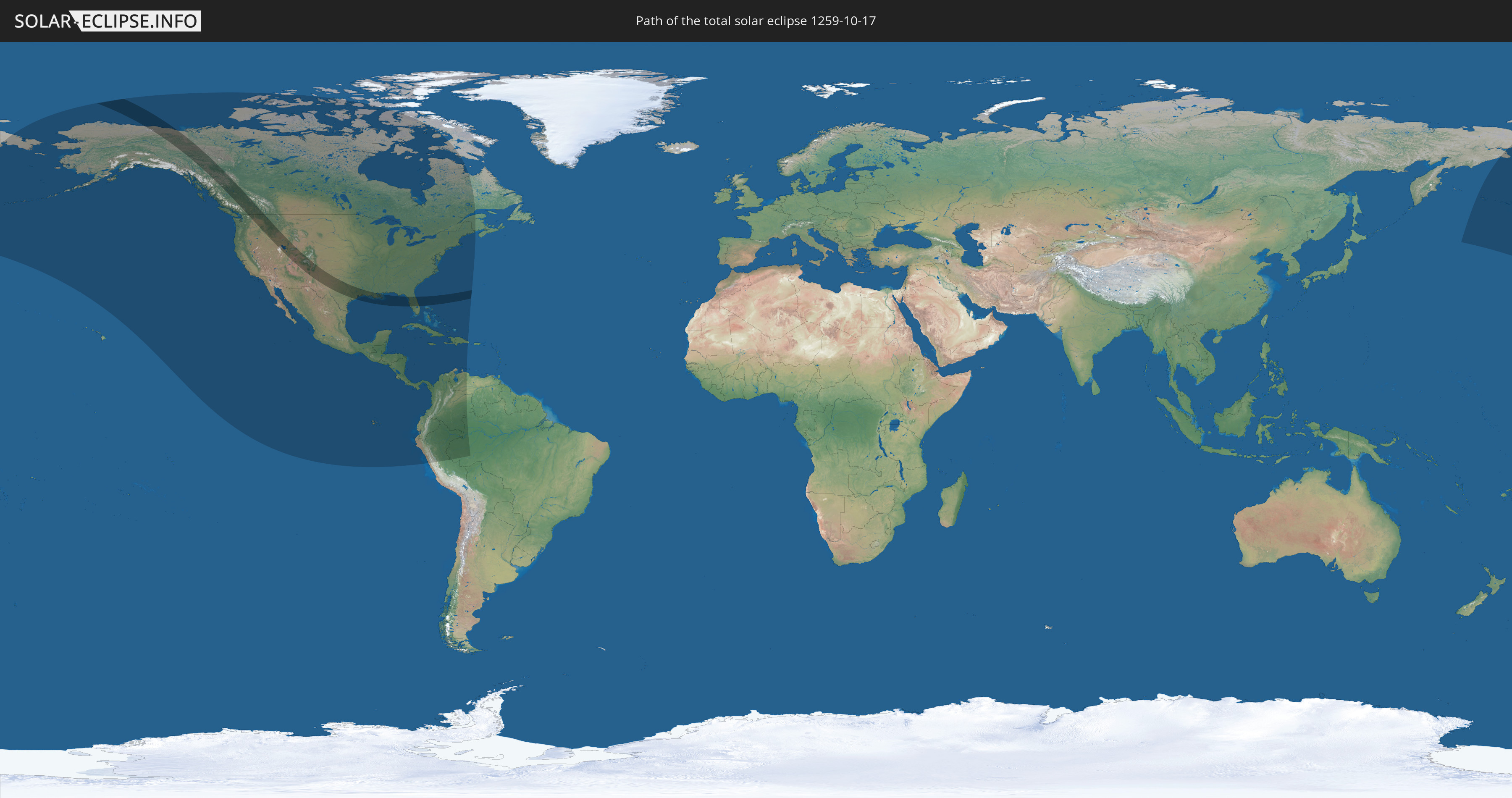
Die Sonnenfinsternis am 10/17/1259 kann man in 26 Ländern als partielle Sonnenfinsternis beobachten.
Der Finsternispfad verläuft durch 2 Länder. Nur in diesen Ländern ist sie als total Sonnenfinsternis zu sehen.
In den folgenden Ländern ist die Sonnenfinsternis total zu sehen
 United States
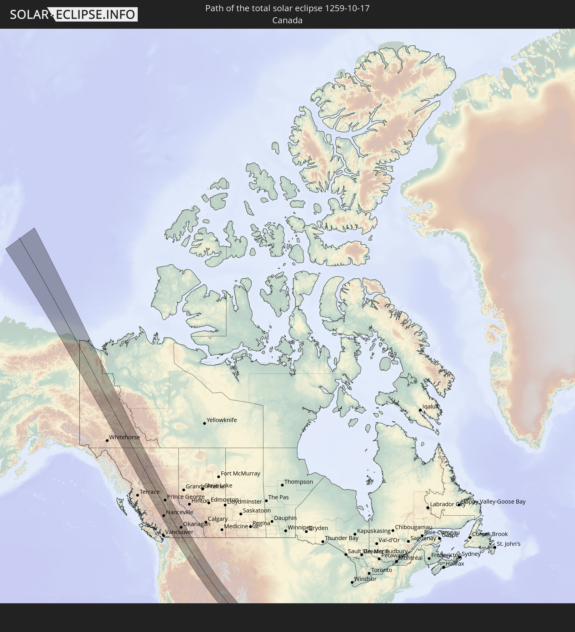 Canada
In den folgenden Ländern ist die Sonnenfinsternis partiell zu sehen


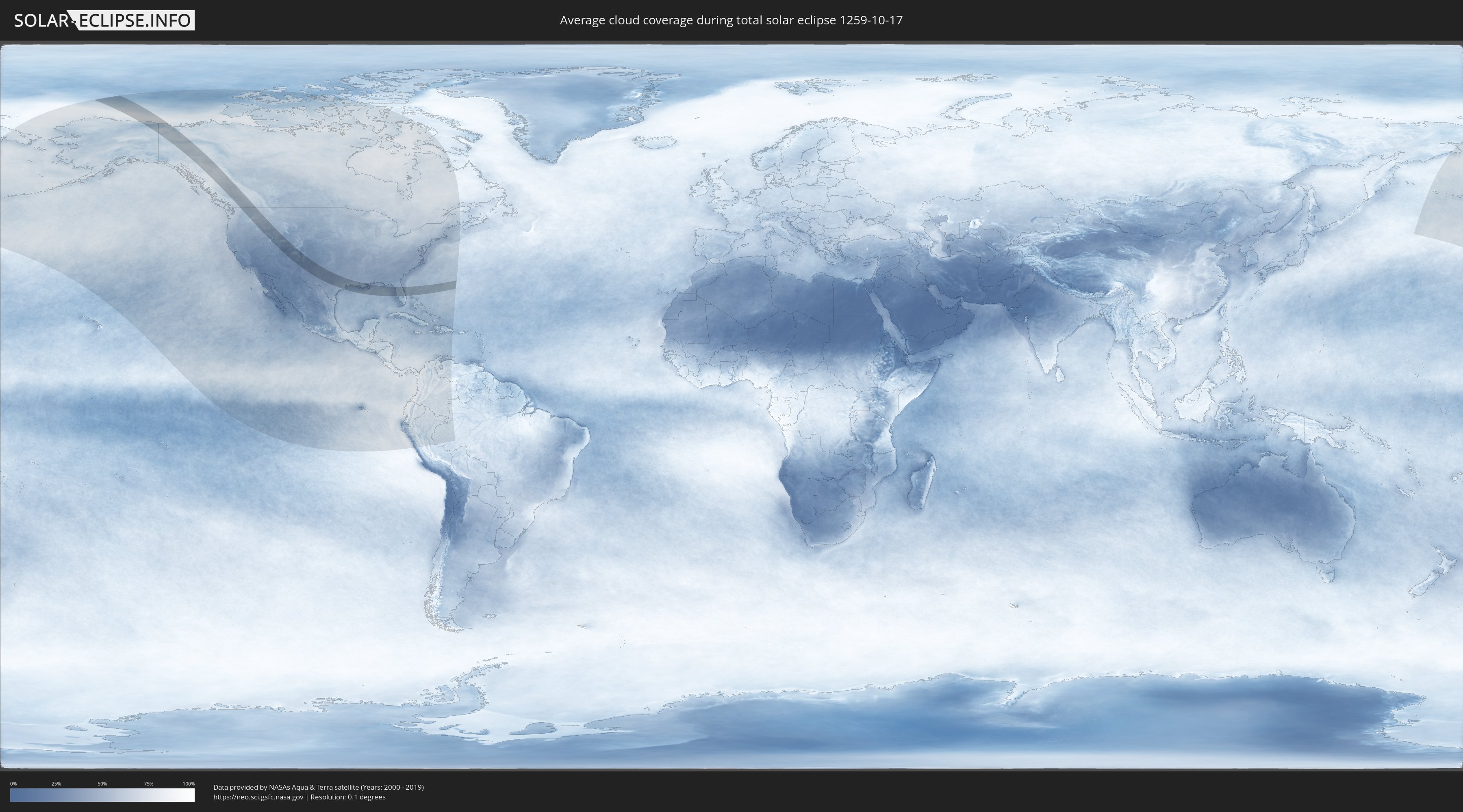
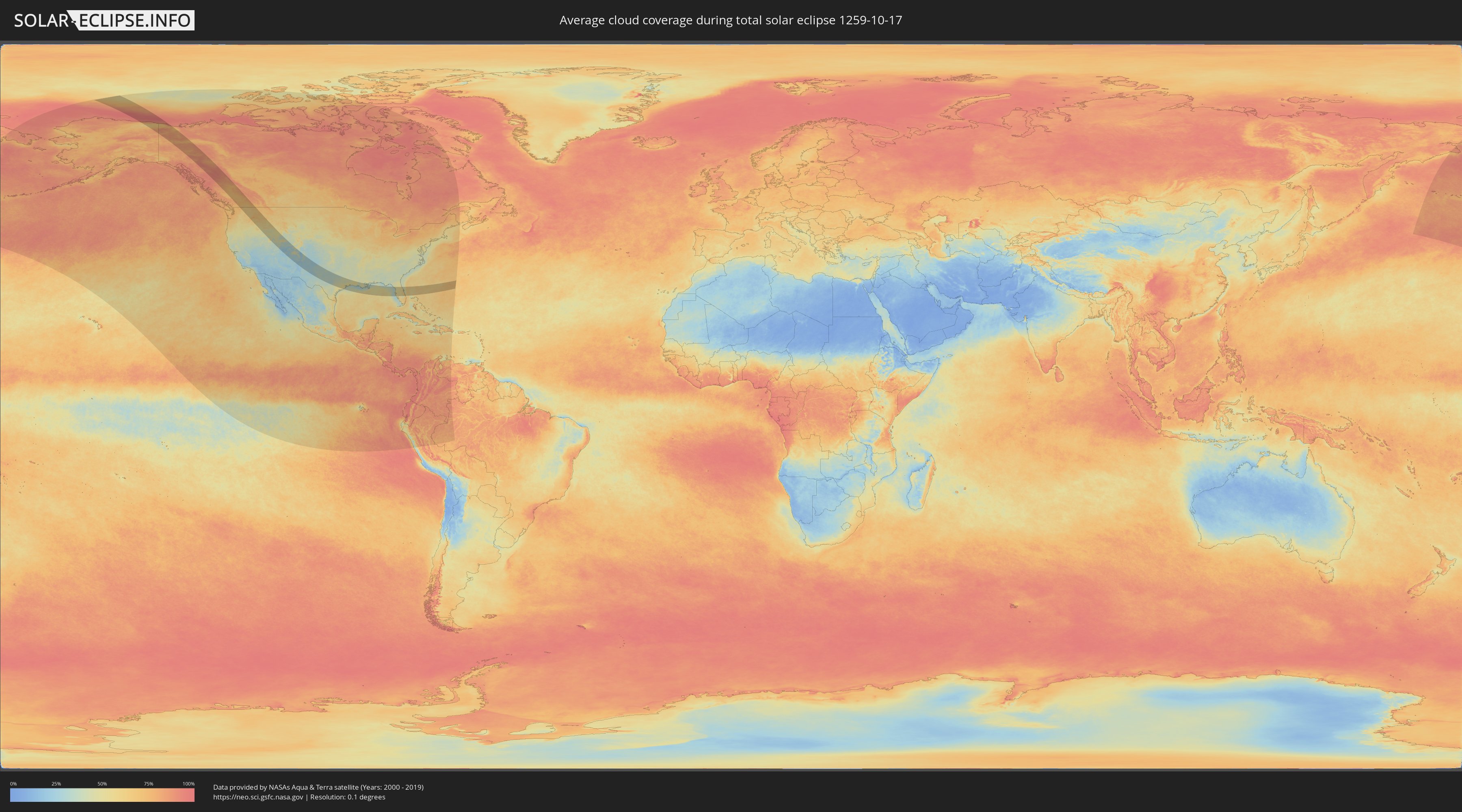
How will be the weather during the total solar eclipse on 10/17/1259?
Where is the best place to see the total solar eclipse of 10/17/1259?
The following maps show the average cloud coverage for the day of the total solar eclipse.
With the help of these maps, it is possible to find the place along the eclipse path, which has the best
chance of a cloudless sky.
Nevertheless, you should consider local circumstances and inform about the weather of your chosen
observation site.
The data is provided by NASAs satellites
AQUA and TERRA.
The cloud maps are averaged over a period of 19 years (2000 - 2019).
Detailed country maps
 United States
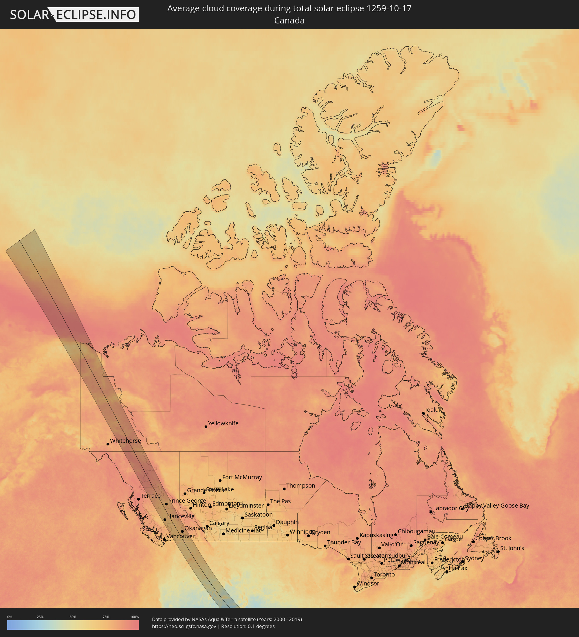 Canada
Cities inside the path of the eclipse
The following table shows all locations with a population of more than 5,000 inside the eclipse path. Cities which have more than 100,000 inhabitants are marked bold. A click at the locations opens a detailed map.
| City | Type | Eclipse duration | Local time of max. eclipse | Distance to central line | Ø Cloud coverage |
 Hanceville, British Columbia
|
total | - | 12:15:20 UTC-08:00 | 76 km | 69% |
|
Prince George, British Columbia
|
total | - | 12:14:18 UTC-08:00 | 50 km | 76% |
|
Quesnel, British Columbia
|
total | - | 12:15:14 UTC-08:00 | 15 km | 78% |
|
Williams Lake, British Columbia
|
total | - | 12:16:15 UTC-08:00 | 10 km | 74% |
|
Merritt, British Columbia
|
total | - | 12:19:33 UTC-08:00 | 42 km | 72% |
|
Kamloops, British Columbia
|
total | - | 12:19:41 UTC-08:00 | 18 km | 72% |
|
Summerland, British Columbia
|
total | - | 12:21:27 UTC-08:00 | 2 km | 69% |
|
Penticton, British Columbia
|
total | - | 12:21:40 UTC-08:00 | 4 km | 69% |
|
West Kelowna, British Columbia
|
total | - | 12:21:19 UTC-08:00 | 18 km | 73% |
|
Kelowna, British Columbia
|
total | - | 12:21:26 UTC-08:00 | 25 km | 71% |
|
Okanagan, British Columbia
|
total | - | 12:21:10 UTC-08:00 | 60 km | 74% |
|
Salmon Arm, British Columbia
|
total | - | 12:20:56 UTC-08:00 | 82 km | 78% |
|
Vernon, British Columbia
|
total | - | 12:21:21 UTC-08:00 | 60 km | 74% |
|
Trail, British Columbia
|
total | - | 12:24:29 UTC-08:00 | 93 km | 68% |
|
Castlegar, British Columbia
|
total | - | 12:24:20 UTC-08:00 | 106 km | 69% |
 Spokane, Washington
|
total | - | 12:26:18 UTC-08:00 | 28 km | 64% |
|
Pullman, Washington
|
total | - | 12:27:38 UTC-08:00 | 11 km | 69% |
|
Lewiston, Idaho
|
total | - | 12:28:12 UTC-08:00 | 19 km | 71% |
|
Coeur d'Alene, Idaho
|
total | - | 12:27:10 UTC-08:00 | 71 km | 63% |
|
Twin Falls, Idaho
|
total | - | 13:36:29 UTC-07:00 | 90 km | 57% |
|
Pocatello, Idaho
|
total | - | 13:39:05 UTC-07:00 | 64 km | 51% |
|
Tooele, Utah
|
total | - | 13:42:30 UTC-07:00 | 82 km | 44% |
|
Magna, Utah
|
total | - | 13:42:33 UTC-07:00 | 57 km | 43% |
|
Idaho Falls, Idaho
|
total | - | 13:38:54 UTC-07:00 | 129 km | 54% |
|
Ogden, Utah
|
total | - | 13:42:02 UTC-07:00 | 13 km | 45% |
|
Layton, Utah
|
total | - | 13:42:16 UTC-07:00 | 24 km | 49% |
|
West Jordan, Utah
|
total | - | 13:42:56 UTC-07:00 | 52 km | 46% |
|
Salt Lake City, Utah
|
total | - | 13:42:48 UTC-07:00 | 39 km | 43% |
|
Lehi, Utah
|
total | - | 13:43:23 UTC-07:00 | 62 km | 43% |
|
Logan, Utah
|
total | - | 13:41:32 UTC-07:00 | 30 km | 48% |
|
Provo, Utah
|
total | - | 13:43:54 UTC-07:00 | 60 km | 39% |
|
Grand Junction, Colorado
|
total | - | 13:50:24 UTC-07:00 | 64 km | 29% |
|
Farmington, New Mexico
|
total | - | 13:54:32 UTC-07:00 | 90 km | 30% |
|
Rio Rancho, New Mexico
|
total | - | 13:59:22 UTC-07:00 | 110 km | 25% |
|
Albuquerque, New Mexico
|
total | - | 13:59:38 UTC-07:00 | 121 km | 24% |
|
Santa Fe, New Mexico
|
total | - | 13:59:46 UTC-07:00 | 28 km | 26% |
|
Roswell, New Mexico
|
total | - | 14:05:46 UTC-07:00 | 136 km | 30% |
|
Clovis, New Mexico
|
total | - | 14:06:06 UTC-07:00 | 28 km | 29% |
|
Hobbs, New Mexico
|
total | - | 14:09:05 UTC-07:00 | 119 km | 27% |
|
Midland, Texas
|
total | - | 15:11:54 UTC-06:00 | 126 km | 32% |
|
Lubbock, Texas
|
total | - | 15:09:33 UTC-06:00 | 30 km | 30% |
|
Plainview, Texas
|
total | - | 15:08:44 UTC-06:00 | 93 km | 33% |
|
Big Spring, Texas
|
total | - | 15:12:22 UTC-06:00 | 71 km | 38% |
|
San Angelo, Texas
|
total | - | 15:15:16 UTC-06:00 | 92 km | 36% |
|
Abilene, Texas
|
total | - | 15:14:37 UTC-06:00 | 36 km | 33% |
|
San Marcos, Texas
|
total | - | 15:21:36 UTC-06:00 | 134 km | 43% |
|
Copperas Cove, Texas
|
total | - | 15:19:31 UTC-06:00 | 8 km | 35% |
|
Leander, Texas
|
total | - | 15:20:32 UTC-06:00 | 61 km | 38% |
|
Austin, Texas
|
total | - | 15:21:13 UTC-06:00 | 87 km | 42% |
|
Killeen, Texas
|
total | - | 15:19:47 UTC-06:00 | 2 km | 38% |
|
Round Rock, Texas
|
total | - | 15:20:54 UTC-06:00 | 60 km | 41% |
|
Cleburne, Texas
|
total | - | 15:18:08 UTC-06:00 | 135 km | 38% |
|
Temple, Texas
|
total | - | 15:20:21 UTC-06:00 | 13 km | 38% |
|
Waco, Texas
|
total | - | 15:19:50 UTC-06:00 | 66 km | 39% |
|
College Station, Texas
|
total | - | 15:22:33 UTC-06:00 | 6 km | 45% |
|
Rosenberg, Texas
|
total | - | 15:25:06 UTC-06:00 | 85 km | 49% |
|
Cypress, Texas
|
total | - | 15:24:33 UTC-06:00 | 38 km | 50% |
|
Sugar Land, Texas
|
total | - | 15:25:14 UTC-06:00 | 72 km | 51% |
|
Huntsville, Texas
|
total | - | 15:23:26 UTC-06:00 | 45 km | 44% |
|
The Woodlands, Texas
|
total | - | 15:24:30 UTC-06:00 | 11 km | 50% |
|
Conroe, Texas
|
total | - | 15:24:16 UTC-06:00 | 6 km | 47% |
|
Lake Jackson, Texas
|
total | - | 15:26:30 UTC-06:00 | 126 km | 51% |
|
Houston, Texas
|
total | - | 15:25:21 UTC-06:00 | 48 km | 52% |
|
Pearland, Texas
|
total | - | 15:25:47 UTC-06:00 | 66 km | 55% |
|
Alvin, Texas
|
total | - | 15:26:05 UTC-06:00 | 79 km | 51% |
|
Pasadena, Texas
|
total | - | 15:25:40 UTC-06:00 | 50 km | 54% |
|
Atascocita, Texas
|
total | - | 15:25:11 UTC-06:00 | 17 km | 50% |
|
League City, Texas
|
total | - | 15:26:08 UTC-06:00 | 65 km | 52% |
|
Baytown, Texas
|
total | - | 15:25:54 UTC-06:00 | 37 km | 49% |
|
Galveston, Texas
|
total | - | 15:26:53 UTC-06:00 | 77 km | 38% |
|
Lufkin, Texas
|
total | - | 15:23:27 UTC-06:00 | 138 km | 44% |
|
Beaumont, Texas
|
total | - | 15:26:26 UTC-06:00 | 28 km | 54% |
|
Port Arthur, Texas
|
total | - | 15:26:59 UTC-06:00 | 12 km | 48% |
|
Lake Charles, Louisiana
|
total | - | 15:27:21 UTC-06:00 | 69 km | 51% |
|
Lafayette, Louisiana
|
total | - | 15:28:48 UTC-06:00 | 103 km | 49% |
|
New Iberia, Louisiana
|
total | - | 15:29:25 UTC-06:00 | 85 km | 50% |
|
Prairieville, Louisiana
|
total | - | 15:29:55 UTC-06:00 | 137 km | 47% |
|
Houma, Louisiana
|
total | - | 15:31:25 UTC-06:00 | 66 km | 47% |
|
Laplace, Louisiana
|
total | - | 15:30:53 UTC-06:00 | 123 km | 46% |
|
Kenner, Louisiana
|
total | - | 15:31:17 UTC-06:00 | 120 km | 47% |
|
New Orleans, Louisiana
|
total | - | 15:31:33 UTC-06:00 | 119 km | 48% |
|
Clearwater, Florida
|
total | - | 16:42:07 UTC-05:00 | 29 km | 46% |
|
East Lake, Florida
|
total | - | 16:41:58 UTC-05:00 | 13 km | 46% |
|
Bayonet Point, Florida
|
total | - | 16:41:38 UTC-05:00 | 11 km | 47% |
|
St. Petersburg, Florida
|
total | - | 16:42:32 UTC-05:00 | 51 km | 43% |
|
Bradenton, Florida
|
total | - | 16:43:04 UTC-05:00 | 81 km | 50% |
|
Sarasota, Florida
|
total | - | 16:43:22 UTC-05:00 | 99 km | 49% |
|
Greater Northdale, Florida
|
total | - | 16:42:07 UTC-05:00 | 13 km | 49% |
|
Spring Hill, Florida
|
total | - | 16:41:31 UTC-05:00 | 28 km | 50% |
|
Tampa, Florida
|
total | - | 16:42:26 UTC-05:00 | 31 km | 42% |
|
Wesley Chapel, Florida
|
total | - | 16:42:04 UTC-05:00 | 2 km | 53% |
|
Brandon, Florida
|
total | - | 16:42:36 UTC-05:00 | 32 km | 53% |
|
Ocala, Florida
|
total | - | 16:40:41 UTC-05:00 | 107 km | 55% |
|
Plant City, Florida
|
total | - | 16:42:36 UTC-05:00 | 23 km | 54% |
|
The Villages, Florida
|
total | - | 16:41:15 UTC-05:00 | 79 km | 50% |
|
Lakeland, Florida
|
total | - | 16:42:42 UTC-05:00 | 21 km | 55% |
|
Clermont, Florida
|
total | - | 16:42:01 UTC-05:00 | 36 km | 50% |
|
Winter Haven, Florida
|
total | - | 16:42:55 UTC-05:00 | 23 km | 54% |
|
Four Corners, Florida
|
total | - | 16:42:29 UTC-05:00 | 11 km | 57% |
|
Apopka, Florida
|
total | - | 16:42:02 UTC-05:00 | 49 km | 58% |
|
Poinciana, Florida
|
total | - | 16:42:56 UTC-05:00 | 10 km | 51% |
|
Kissimmee, Florida
|
total | - | 16:42:42 UTC-05:00 | 8 km | 49% |
|
Orlando, Florida
|
total | - | 16:42:22 UTC-05:00 | 34 km | 57% |
|
Winter Springs, Florida
|
total | - | 16:42:09 UTC-05:00 | 51 km | 55% |
|
Deltona, Florida
|
total | - | 16:41:52 UTC-05:00 | 74 km | 54% |
|
Alafaya, Florida
|
total | - | 16:42:27 UTC-05:00 | 36 km | 57% |
|
Daytona Beach, Florida
|
total | - | 16:41:33 UTC-05:00 | 108 km | 51% |
|
New Smyrna Beach, Florida
|
total | - | 16:41:55 UTC-05:00 | 87 km | 49% |
|
Titusville, Florida
|
total | - | 16:42:41 UTC-05:00 | 40 km | 54% |
|
Rockledge, Florida
|
total | - | 16:43:11 UTC-05:00 | 11 km | 55% |
|
Merritt Island, Florida
|
total | - | 16:42:55 UTC-05:00 | 32 km | 53% |
|
Palm Bay, Florida
|
total | - | 16:43:47 UTC-05:00 | 25 km | 55% |
|
Vero Beach South, Florida
|
total | - | 16:44:35 UTC-05:00 | 72 km | 60% |
|
Port Saint Lucie, Florida
|
total | - | 16:45:09 UTC-05:00 | 108 km | 65% |
|
Fort Pierce, Florida
|
total | - | 16:44:56 UTC-05:00 | 91 km | 59% |