Total solar eclipse of 03/12/1290
| Day of week: | Sunday |
| Maximum duration of eclipse: | 04m52s |
| Maximum width of eclipse path: | 238 km |
| Saros cycle: | 118 |
| Coverage: | 100% |
| Magnitude: | 1.0604 |
| Gamma: | -0.5611 |
Wo kann man die Sonnenfinsternis vom 03/12/1290 sehen?

Die Sonnenfinsternis am 03/12/1290 kann man in 19 Ländern als partielle Sonnenfinsternis beobachten.
Der Finsternispfad verläuft durch 4 Länder. Nur in diesen Ländern ist sie als total Sonnenfinsternis zu sehen.
In den folgenden Ländern ist die Sonnenfinsternis total zu sehen
 Chile
Chile
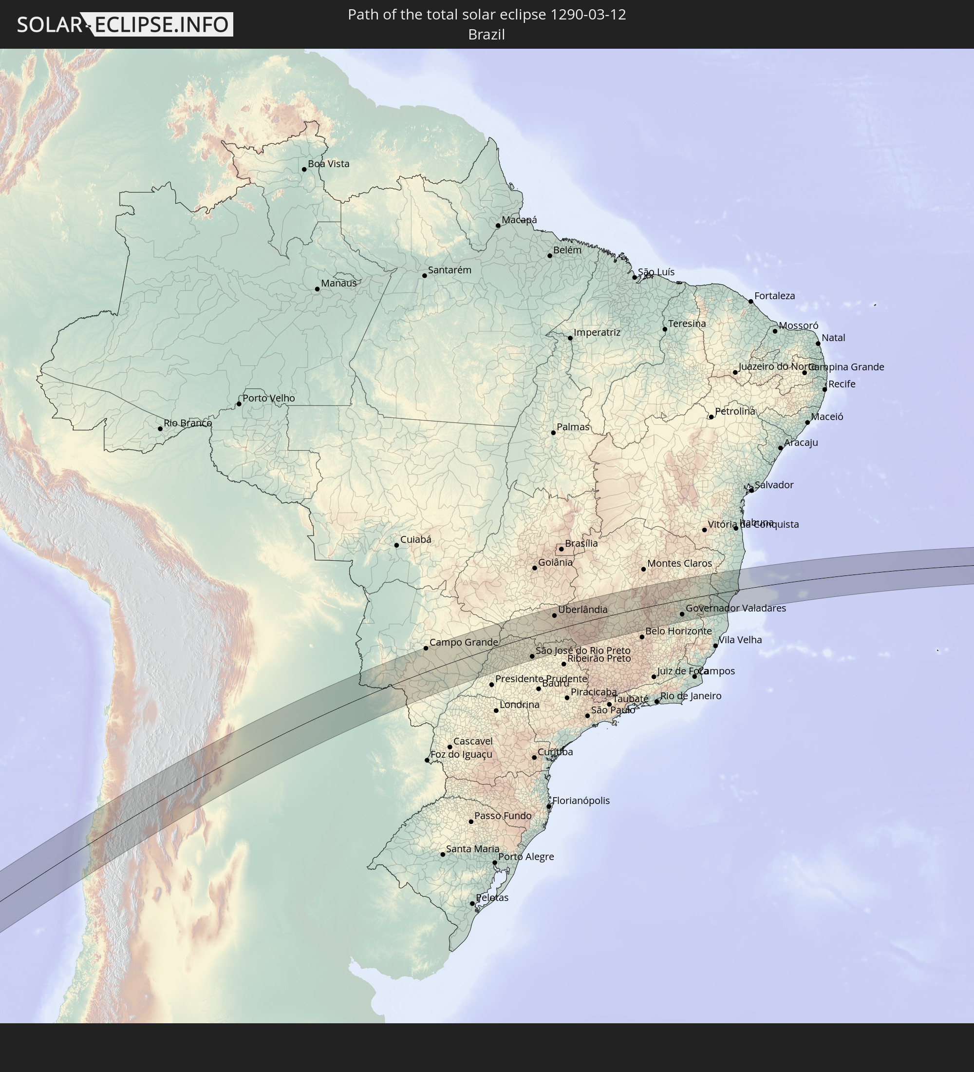 Brazil
 Argentina
 Paraguay
In den folgenden Ländern ist die Sonnenfinsternis partiell zu sehen


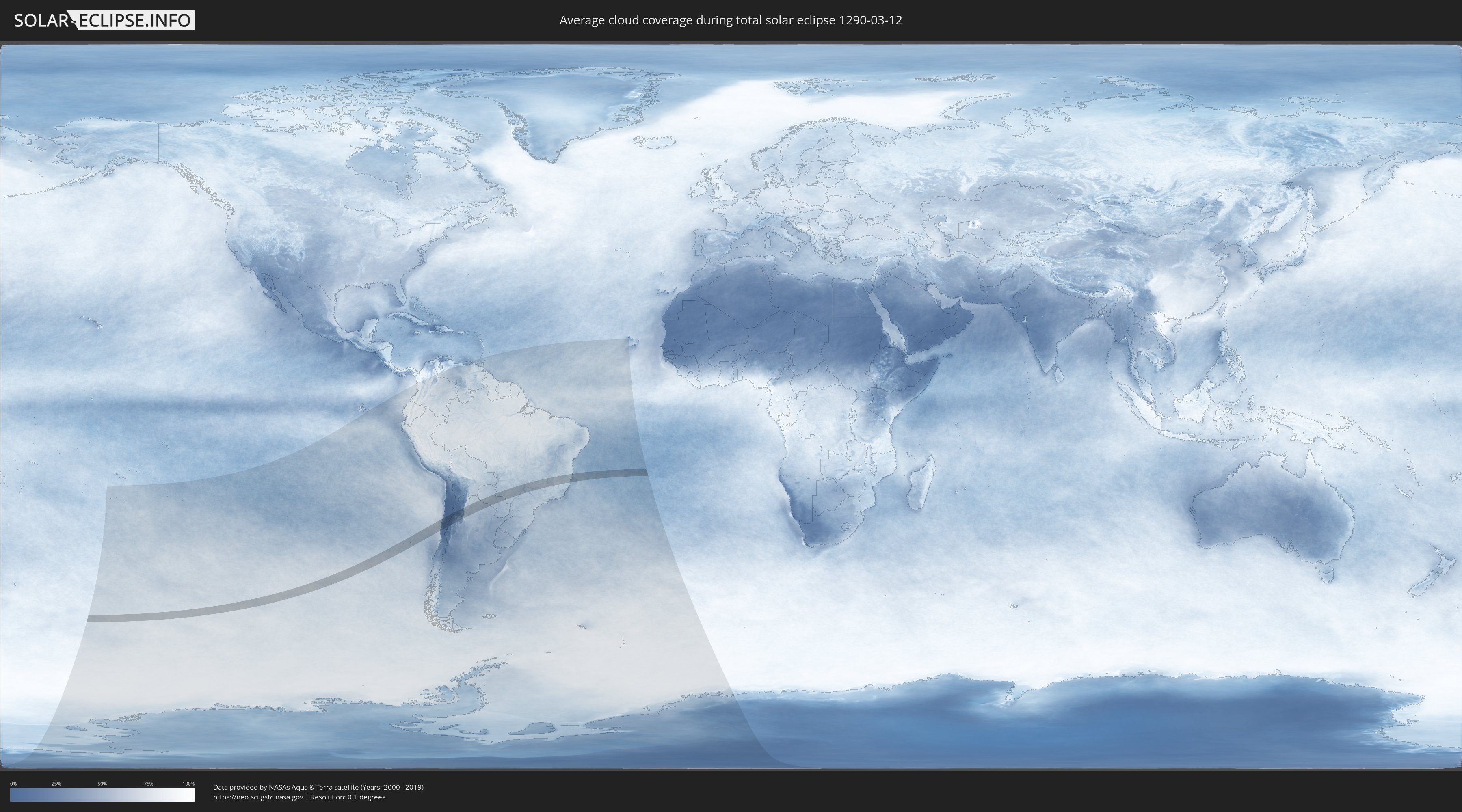
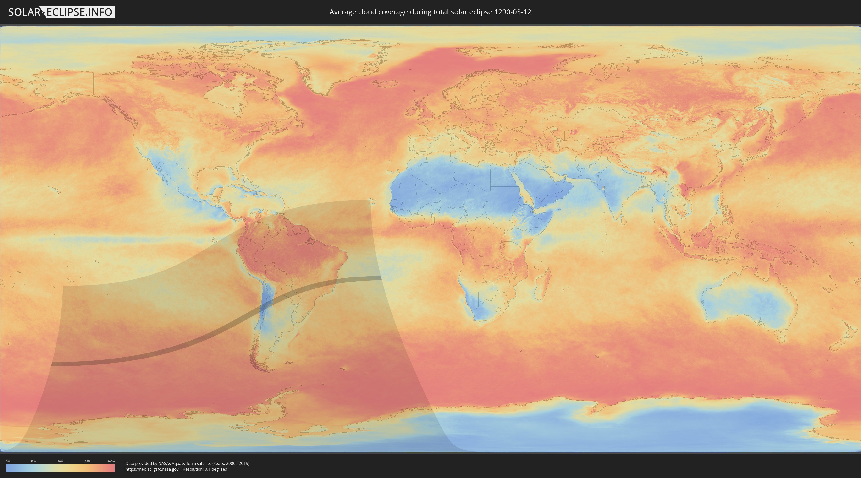
How will be the weather during the total solar eclipse on 03/12/1290?
Where is the best place to see the total solar eclipse of 03/12/1290?
The following maps show the average cloud coverage for the day of the total solar eclipse.
With the help of these maps, it is possible to find the place along the eclipse path, which has the best
chance of a cloudless sky.
Nevertheless, you should consider local circumstances and inform about the weather of your chosen
observation site.
The data is provided by NASAs satellites
AQUA and TERRA.
The cloud maps are averaged over a period of 19 years (2000 - 2019).
Detailed country maps
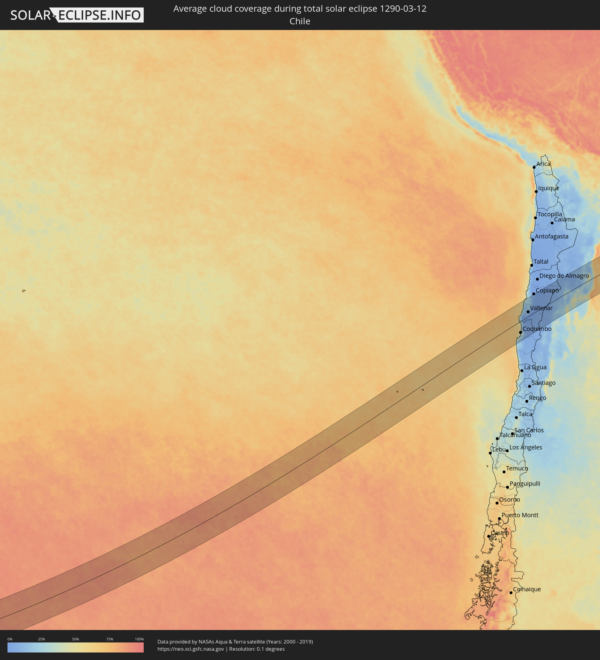 Chile
Chile
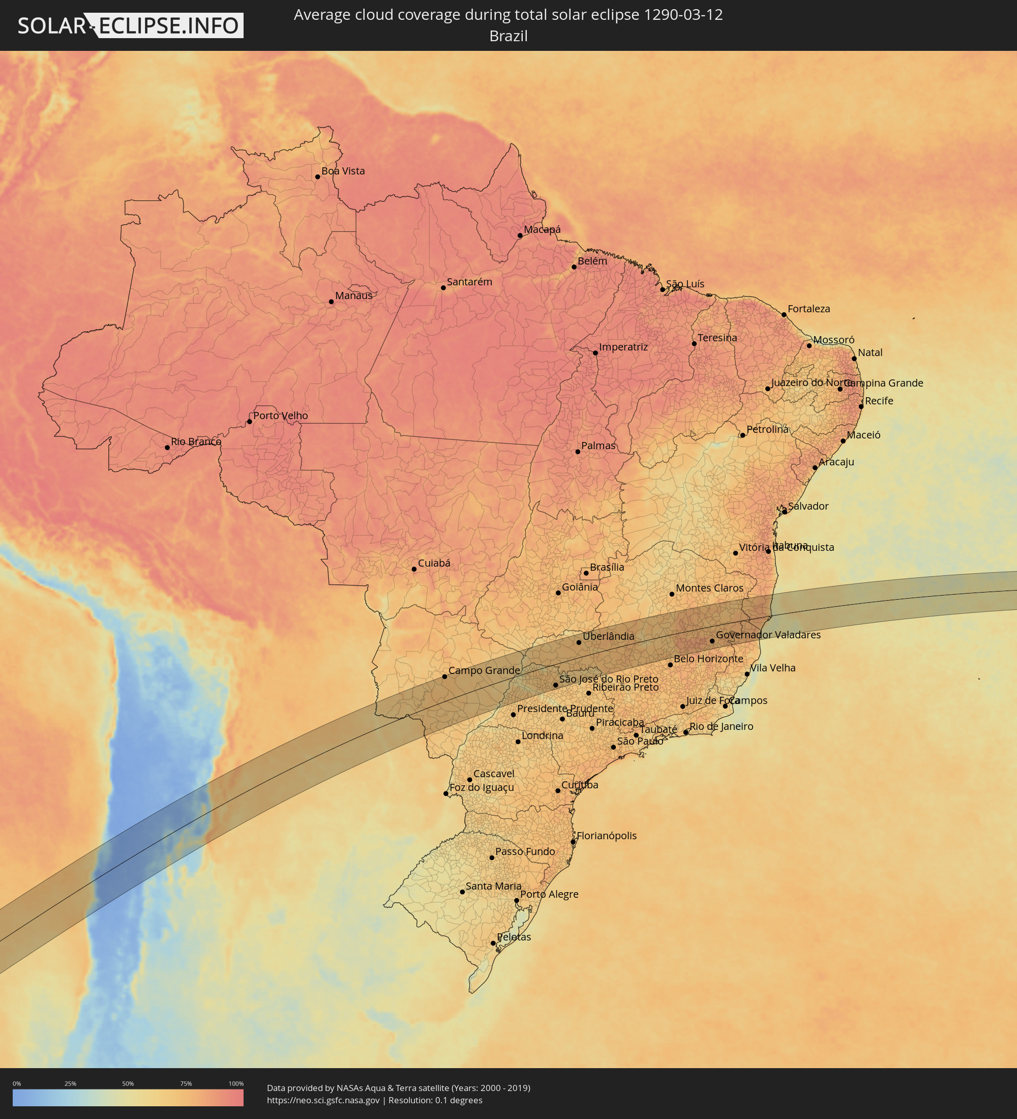 Brazil
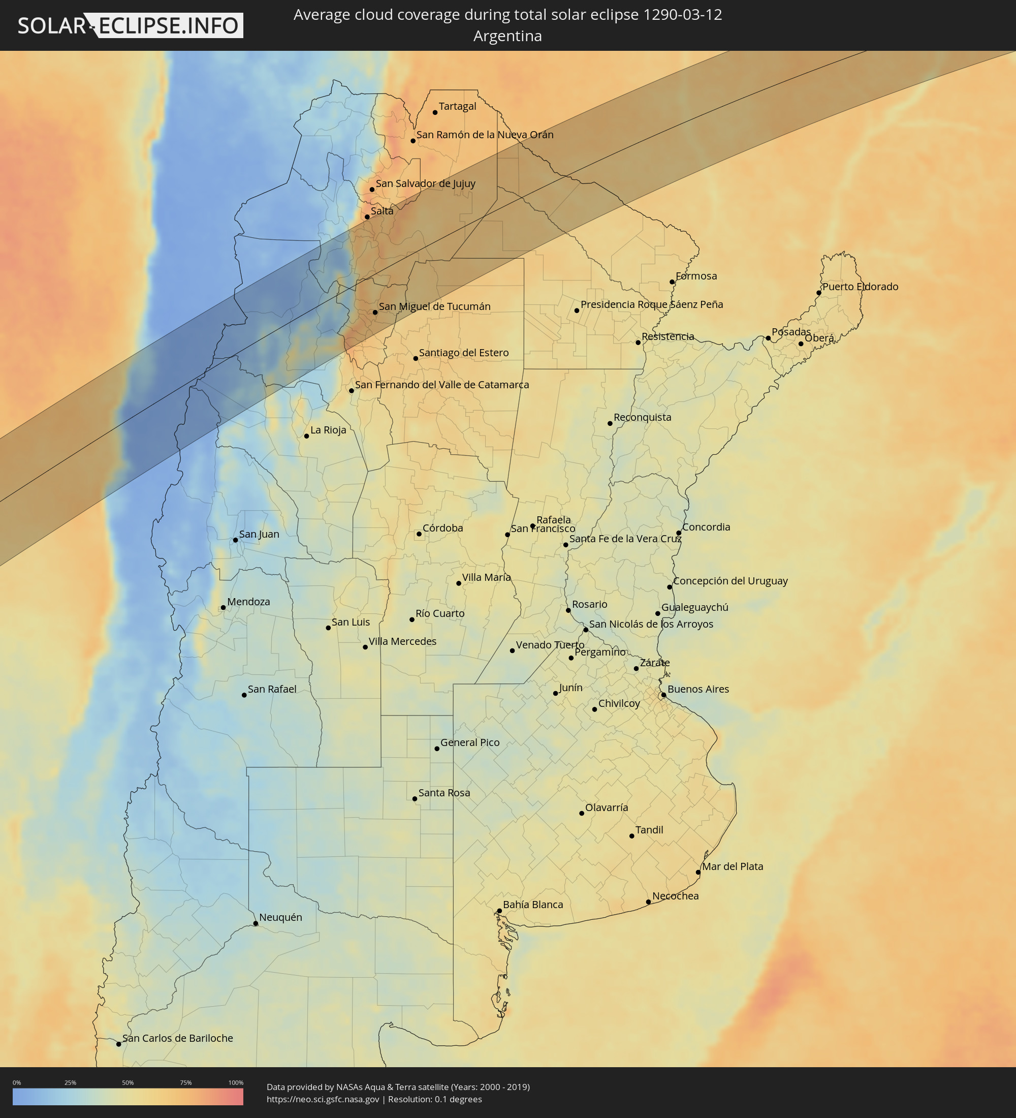 Argentina
 Paraguay
Cities inside the path of the eclipse
The following table shows all locations with a population of more than 5,000 inside the eclipse path. Cities which have more than 100,000 inhabitants are marked bold. A click at the locations opens a detailed map.
| City | Type | Eclipse duration | Local time of max. eclipse | Distance to central line | Ø Cloud coverage |
 Coquimbo, Coquimbo
|
total | - | 13:38:56 UTC-04:42 | 72 km | 33% |
|
La Serena, Coquimbo
|
total | - | 13:39:10 UTC-04:42 | 72 km | 35% |
|
Vallenar, Atacama
|
total | - | 13:42:09 UTC-04:42 | 28 km | 11% |
|
Vicuña, Coquimbo
|
total | - | 13:40:00 UTC-04:42 | 112 km | 3% |
|
Copiapó, Atacama
|
total | - | 13:44:52 UTC-04:42 | 121 km | 6% |
 Fiambalá, Catamarca Province
|
total | - | 14:15:26 UTC-04:16 | 47 km | 17% |
|
Tinogasta, Catamarca Province
|
total | - | 14:14:56 UTC-04:16 | 86 km | 32% |
|
Andalgalá, Catamarca Province
|
total | - | 14:17:56 UTC-04:16 | 103 km | 33% |
|
Cafayate, Salta Province
|
total | - | 14:21:00 UTC-04:16 | 28 km | 45% |
|
Aguilares, Tucumán Province
|
total | - | 14:19:28 UTC-04:16 | 122 km | 70% |
|
Chicoana, Salta Province
|
total | - | 14:23:21 UTC-04:16 | 101 km | 65% |
|
Monteros, Tucumán Province
|
total | - | 14:20:06 UTC-04:16 | 102 km | 70% |
|
El Carril, Salta Province
|
total | - | 14:23:28 UTC-04:16 | 102 km | 65% |
|
Famaillá, Tucumán Province
|
total | - | 14:20:27 UTC-04:16 | 95 km | 70% |
|
Simoca, Tucumán Province
|
total | - | 14:20:12 UTC-04:16 | 118 km | 69% |
|
Yerba Buena, Tucumán Province
|
total | - | 14:20:59 UTC-04:16 | 76 km | 72% |
|
Bella Vista, Tucumán Province
|
total | - | 14:20:39 UTC-04:16 | 98 km | 70% |
|
Trancas, Tucumán Province
|
total | - | 14:22:00 UTC-04:16 | 20 km | 60% |
|
Tafí Viejo, Tucumán Province
|
total | - | 14:21:13 UTC-04:16 | 71 km | 73% |
|
San Miguel de Tucumán, Tucumán Province
|
total | - | 14:21:08 UTC-04:16 | 82 km | 70% |
|
Alderetes, Tucumán Province
|
total | - | 14:21:18 UTC-04:16 | 85 km | 69% |
|
El Galpón, Salta Province
|
total | - | 14:24:27 UTC-04:16 | 32 km | 65% |
|
Las Lajitas, Salta Province
|
total | - | 14:26:17 UTC-04:16 | 81 km | 66% |
|
Joaquín V. González, Salta Province
|
total | - | 14:25:45 UTC-04:16 | 39 km | 64% |
|
El Quebrachal, Salta Province
|
total | - | 14:25:38 UTC-04:16 | 14 km | 64% |
|
Apolinario Saravia, Salta Province
|
total | - | 14:27:07 UTC-04:16 | 94 km | 67% |
|
Taco Pozo, Chaco Province
|
total | - | 14:26:26 UTC-04:16 | 56 km | 68% |
|
Ingeniero Guillermo N. Juárez, Formosa Province
|
total | - | 14:31:36 UTC-04:16 | 49 km | 69% |
|
Las Lomitas, Formosa Province
|
total | - | 14:32:20 UTC-04:16 | 88 km | 61% |
 Colonia Menno, Boquerón
|
total | - | 15:03:26 UTC-03:50 | 115 km | 71% |
|
Concepción, Concepción
|
total | - | 15:05:24 UTC-03:50 | 89 km | 58% |
|
Horqueta, Concepción
|
total | - | 15:06:02 UTC-03:50 | 98 km | 64% |
|
Bella Vista, Amambay
|
total | - | 15:08:42 UTC-03:50 | 5 km | 62% |
 Jardim, Mato Grosso do Sul
|
total | - | 15:22:27 UTC-03:38 | 58 km | 68% |
|
Pedro Juan Caballero, Amambay
|
total | - | 15:09:10 UTC-03:50 | 68 km | 70% |
|
Ponta Porã, Mato Grosso do Sul
|
total | - | 15:21:23 UTC-03:38 | 67 km | 70% |
|
Dourados, Mato Grosso do Sul
|
total | - | 15:23:08 UTC-03:38 | 69 km | 70% |
|
Campo Grande, Mato Grosso do Sul
|
total | - | 15:26:04 UTC-03:38 | 111 km | 74% |
|
Campo Verde, Mato Grosso do Sul
|
total | - | 15:26:52 UTC-03:38 | 93 km | 70% |
|
Presidente Epitácio, São Paulo
|
total | - | 15:59:18 UTC-03:06 | 116 km | 61% |
|
Três Lagoas, Mato Grosso do Sul
|
total | - | 15:29:16 UTC-03:38 | 27 km | 60% |
|
Andradina, São Paulo
|
total | - | 16:01:29 UTC-03:06 | 49 km | 69% |
|
Ilha Solteira, São Paulo
|
total | - | 16:02:13 UTC-03:06 | 1 km | 54% |
|
Paranaíba, Mato Grosso do Sul
|
total | - | 15:31:30 UTC-03:38 | 75 km | 61% |
|
Mirandopólis, São Paulo
|
total | - | 16:01:28 UTC-03:06 | 83 km | 67% |
|
Santa Fé do Sul, São Paulo
|
total | - | 16:03:02 UTC-03:06 | 10 km | 60% |
|
Guararapes, São Paulo
|
total | - | 16:01:49 UTC-03:06 | 111 km | 67% |
|
Jales, São Paulo
|
total | - | 16:03:23 UTC-03:06 | 8 km | 67% |
|
Araçatuba, São Paulo
|
total | - | 16:02:08 UTC-03:06 | 112 km | 72% |
|
Fernandópolis, São Paulo
|
total | - | 16:03:42 UTC-03:06 | 19 km | 72% |
|
Iturama, Minas Gerais
|
total | - | 16:04:34 UTC-03:06 | 38 km | 67% |
|
Votuporanga, São Paulo
|
total | - | 16:03:48 UTC-03:06 | 42 km | 72% |
|
Ituiutaba, Minas Gerais
|
total | - | 16:06:27 UTC-03:06 | 97 km | 67% |
|
São José do Rio Preto, São Paulo
|
total | - | 16:03:53 UTC-03:06 | 103 km | 72% |
|
Frutal, Minas Gerais
|
total | - | 16:05:31 UTC-03:06 | 31 km | 71% |
|
Olímpia, São Paulo
|
total | - | 16:04:31 UTC-03:06 | 108 km | 67% |
|
Barretos, São Paulo
|
total | - | 16:05:09 UTC-03:06 | 98 km | 68% |
|
Guaíra, São Paulo
|
total | - | 16:05:46 UTC-03:06 | 80 km | 69% |
|
Uberlândia, Minas Gerais
|
total | - | 16:07:47 UTC-03:06 | 69 km | 74% |
|
Araguari, Minas Gerais
|
total | - | 16:08:16 UTC-03:06 | 96 km | 71% |
|
Uberaba, Minas Gerais
|
total | - | 16:06:58 UTC-03:06 | 30 km | 70% |
|
Ituverava, São Paulo
|
total | - | 16:06:17 UTC-03:06 | 97 km | 67% |
|
Igarapava, São Paulo
|
total | - | 16:06:45 UTC-03:06 | 66 km | 61% |
|
Monte Carmelo, Minas Gerais
|
total | - | 16:08:51 UTC-03:06 | 69 km | 75% |
|
Patrocínio, Minas Gerais
|
total | - | 16:09:03 UTC-03:06 | 31 km | 77% |
|
Araxá, Minas Gerais
|
total | - | 16:08:11 UTC-03:06 | 40 km | 71% |
|
Patos de Minas, Minas Gerais
|
total | - | 16:10:00 UTC-03:06 | 59 km | 72% |
|
Carmo do Paranaíba, Minas Gerais
|
total | - | 16:09:37 UTC-03:06 | 8 km | 72% |
|
São Gotardo, Minas Gerais
|
total | - | 16:09:26 UTC-03:06 | 32 km | 76% |
|
Bom Despacho, Minas Gerais
|
total | - | 16:09:35 UTC-03:06 | 98 km | 73% |
|
Pompéu, Minas Gerais
|
total | - | 16:10:35 UTC-03:06 | 51 km | 71% |
|
Curvelo, Minas Gerais
|
total | - | 16:11:40 UTC-03:06 | 12 km | 69% |
|
Sete Lagoas, Minas Gerais
|
total | - | 16:10:51 UTC-03:06 | 93 km | 76% |
|
Matozinhos, Minas Gerais
|
total | - | 16:10:52 UTC-03:06 | 107 km | 74% |
|
Diamantina, Minas Gerais
|
total | - | 16:13:03 UTC-03:06 | 25 km | 77% |
|
Guanhães, Minas Gerais
|
total | - | 16:12:54 UTC-03:06 | 47 km | 83% |
|
Governador Valadares, Minas Gerais
|
total | - | 16:13:34 UTC-03:06 | 76 km | 75% |
|
Teófilo Otoni, Minas Gerais
|
total | - | 16:15:12 UTC-03:06 | 24 km | 73% |
|
Nova Venécia, Espírito Santo
|
total | - | 16:14:53 UTC-03:06 | 91 km | 78% |
|
Nanuque, Minas Gerais
|
total | - | 16:16:03 UTC-03:06 | 4 km | 76% |
|
São Mateus, Espírito Santo
|
total | - | 16:15:15 UTC-03:06 | 102 km | 71% |
|
Mucuri, Bahia
|
total | - | 16:48:44 UTC-02:34 | 38 km | 55% |
|
Itamaraju, Bahia
|
total | - | 16:50:04 UTC-02:34 | 77 km | 79% |
|
Nova Viçosa, Bahia
|
total | - | 16:49:06 UTC-02:34 | 19 km | 56% |