Total solar eclipse of 12/10/1349
| Day of week: | Wednesday |
| Maximum duration of eclipse: | 03m06s |
| Maximum width of eclipse path: | 264 km |
| Saros cycle: | 102 |
| Coverage: | 100% |
| Magnitude: | 1.0371 |
| Gamma: | 0.8811 |
Wo kann man die Sonnenfinsternis vom 12/10/1349 sehen?
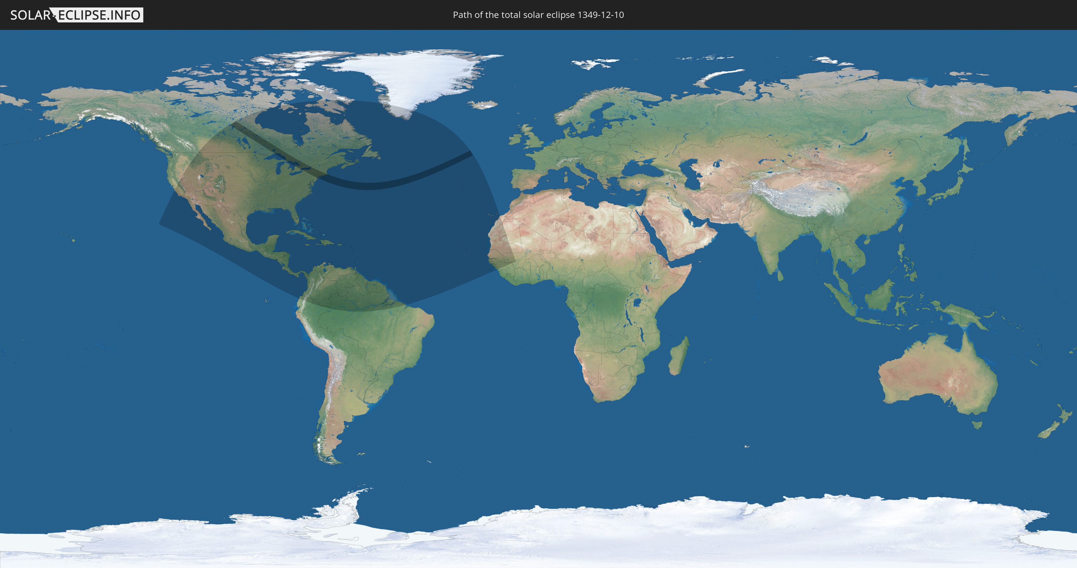
Die Sonnenfinsternis am 12/10/1349 kann man in 57 Ländern als partielle Sonnenfinsternis beobachten.
Der Finsternispfad verläuft durch 3 Länder. Nur in diesen Ländern ist sie als total Sonnenfinsternis zu sehen.
In den folgenden Ländern ist die Sonnenfinsternis total zu sehen
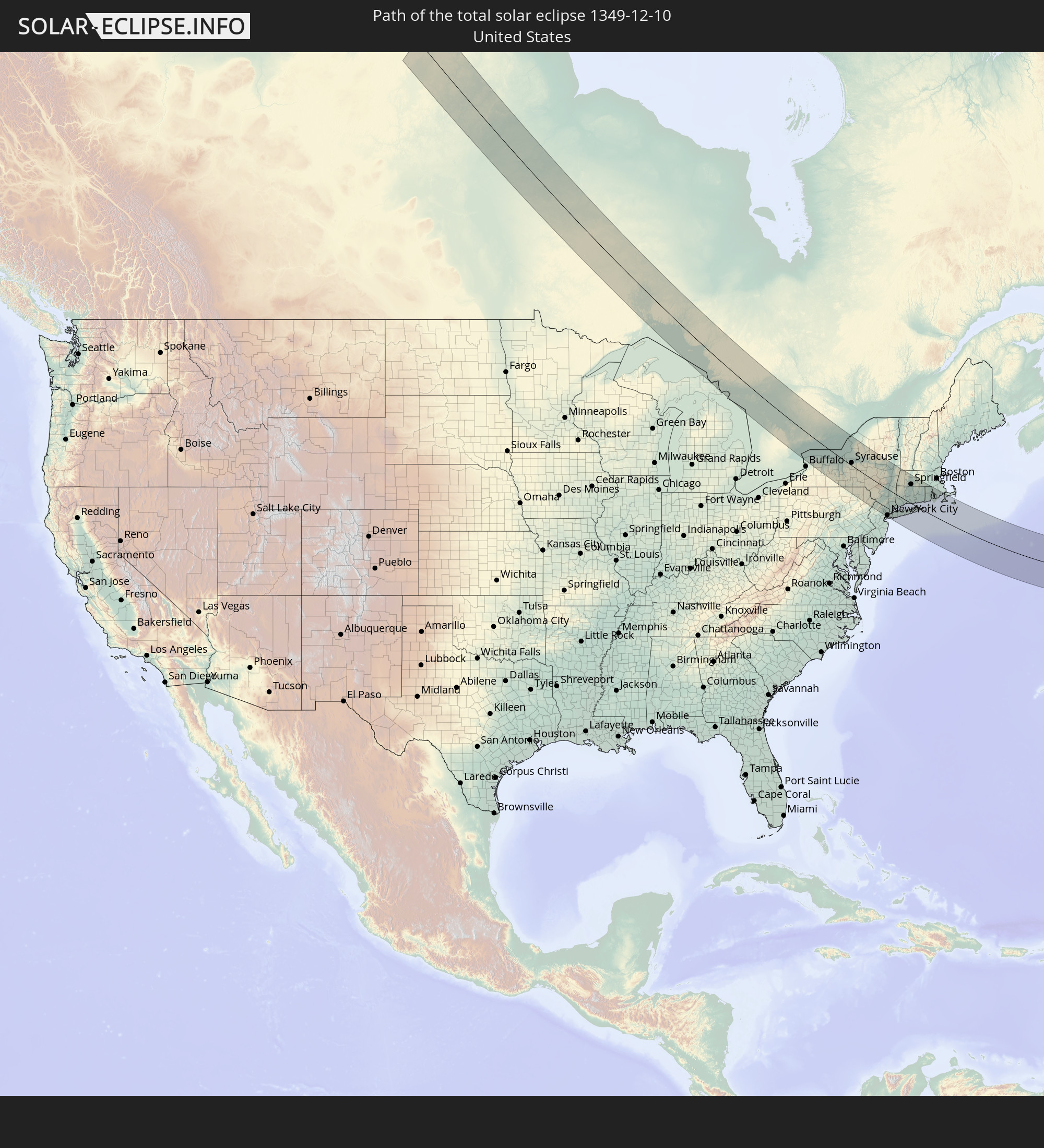 United States
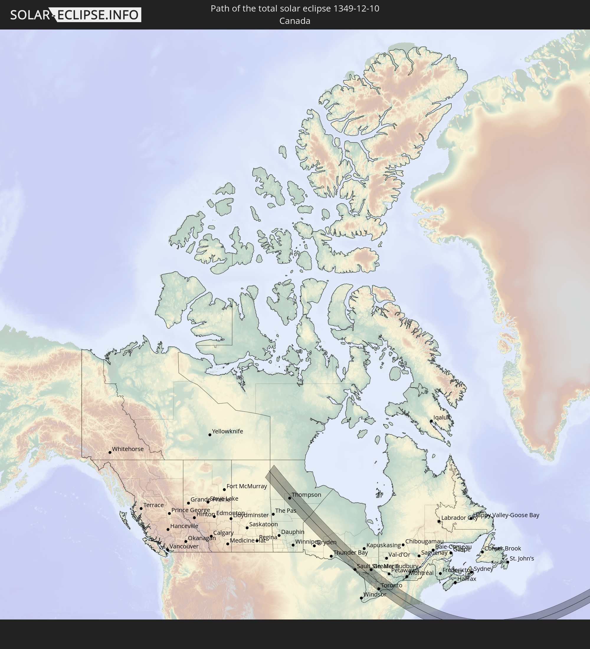 Canada
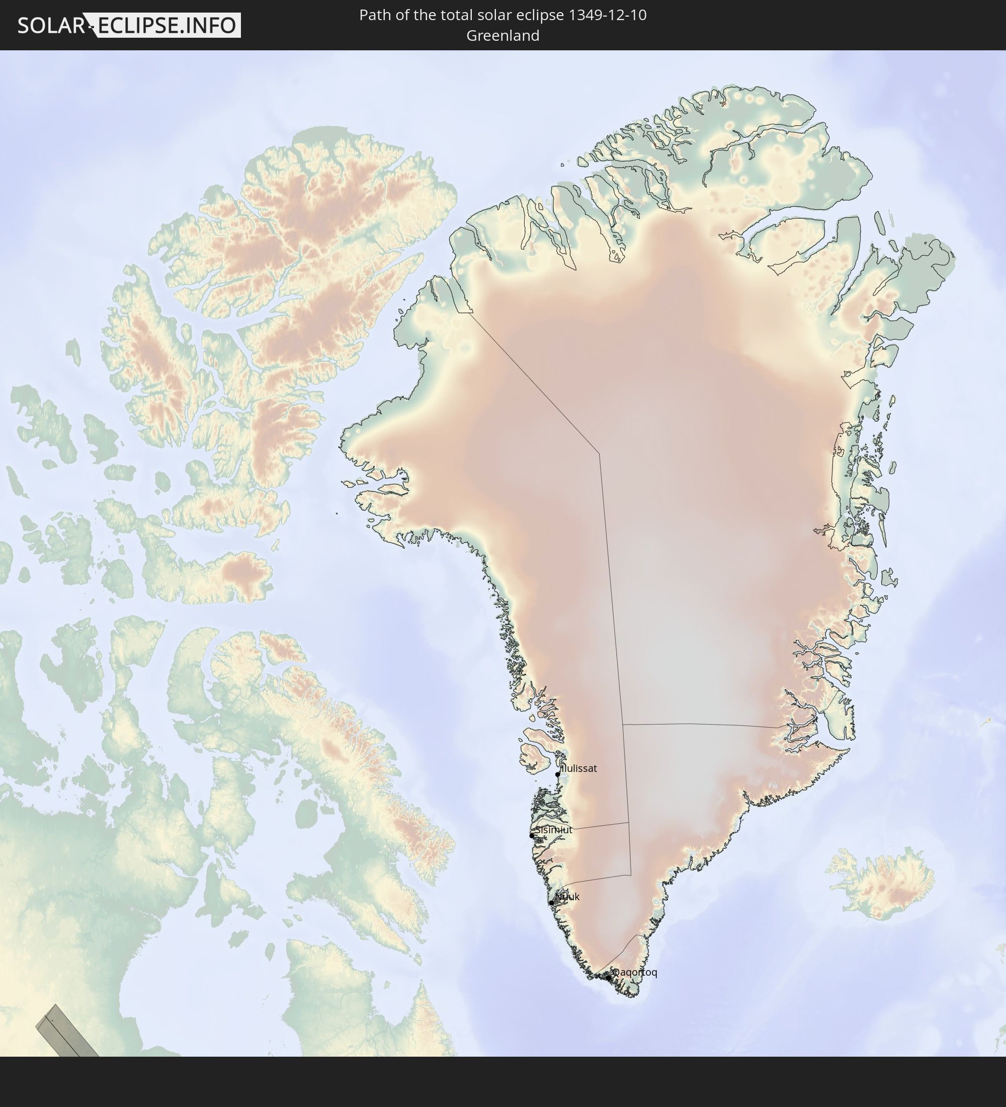 Greenland
In den folgenden Ländern ist die Sonnenfinsternis partiell zu sehen
 United States
 United States Minor Outlying Islands
 Canada
 Mexico
 Greenland
 Guatemala
 Ecuador
 El Salvador
 Honduras
 Belize
 Nicaragua
 Costa Rica
 Cuba
Cuba
 Panama
 Colombia
 Cayman Islands
 Peru
Peru
 The Bahamas
 Jamaica
 Haiti
Haiti
 Brazil
 Venezuela
 Turks and Caicos Islands
 Dominican Republic
 Aruba
Aruba
 Puerto Rico
 United States Virgin Islands
 Bermuda
 British Virgin Islands
 Anguilla
 Collectivity of Saint Martin
 Saint Barthélemy
 Saint Kitts and Nevis
 Antigua and Barbuda
 Montserrat
 Trinidad and Tobago
 Guadeloupe
 Grenada
 Dominica
 Saint Vincent and the Grenadines
 Guyana
 Martinique
 Saint Lucia
 Barbados
 Suriname
 Saint Pierre and Miquelon
 French Guiana
 Portugal
 Cabo Verde
 Spain
Spain
 Senegal
 Mauritania
 The Gambia
 Guinea-Bissau
 Guinea
 Morocco
 Mali
Mali
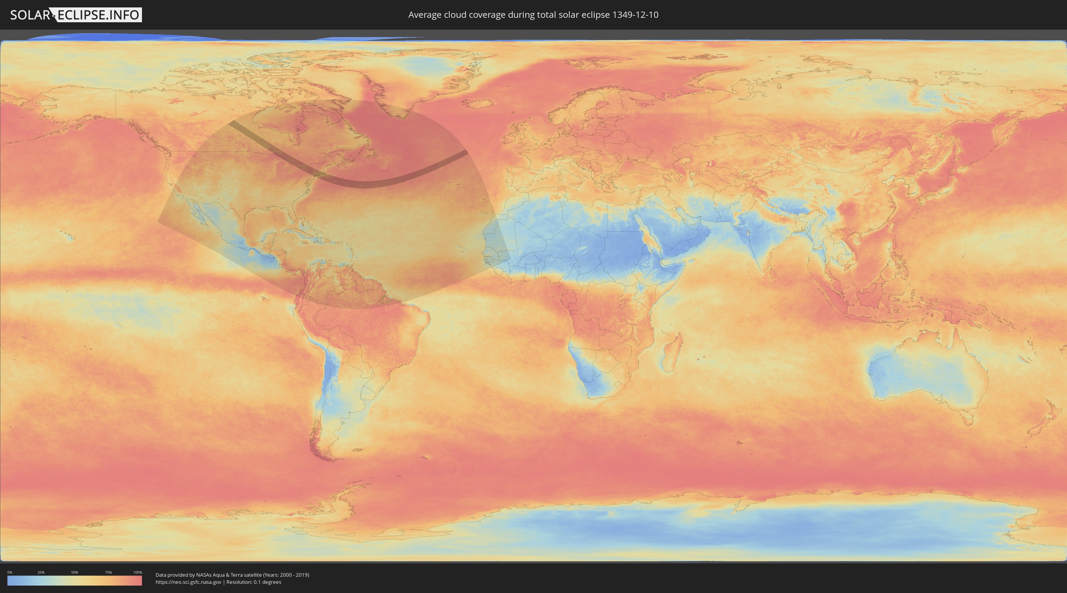
How will be the weather during the total solar eclipse on 12/10/1349?
Where is the best place to see the total solar eclipse of 12/10/1349?
The following maps show the average cloud coverage for the day of the total solar eclipse.
With the help of these maps, it is possible to find the place along the eclipse path, which has the best
chance of a cloudless sky.
Nevertheless, you should consider local circumstances and inform about the weather of your chosen
observation site.
The data is provided by NASAs satellites
AQUA and TERRA.
The cloud maps are averaged over a period of 19 years (2000 - 2019).

Detailed country maps
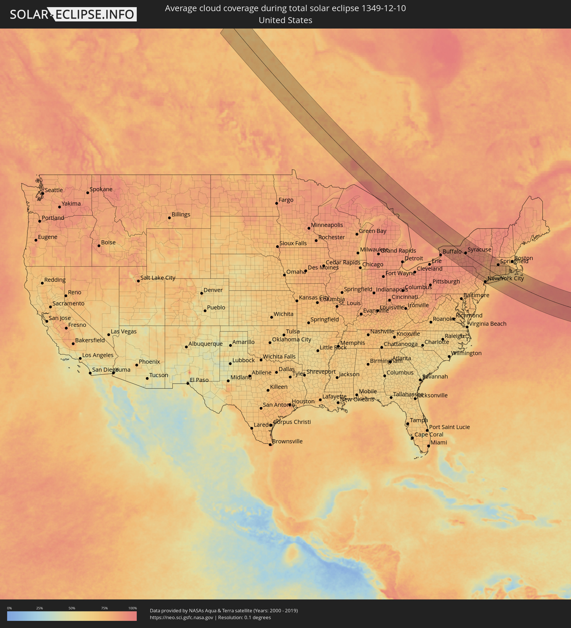 United States
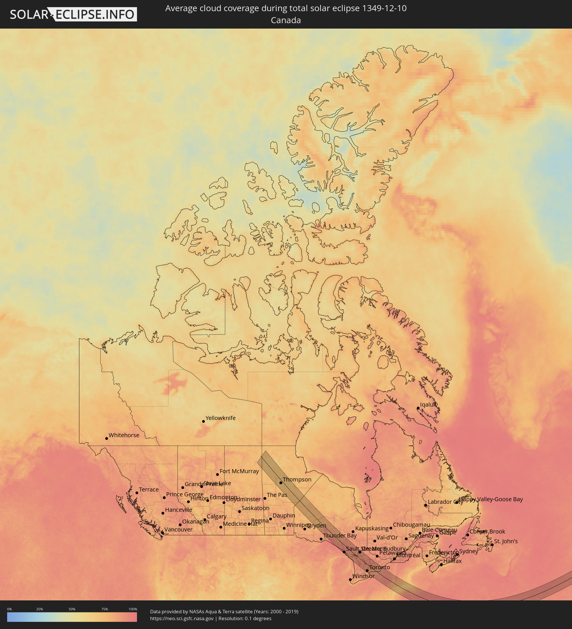 Canada
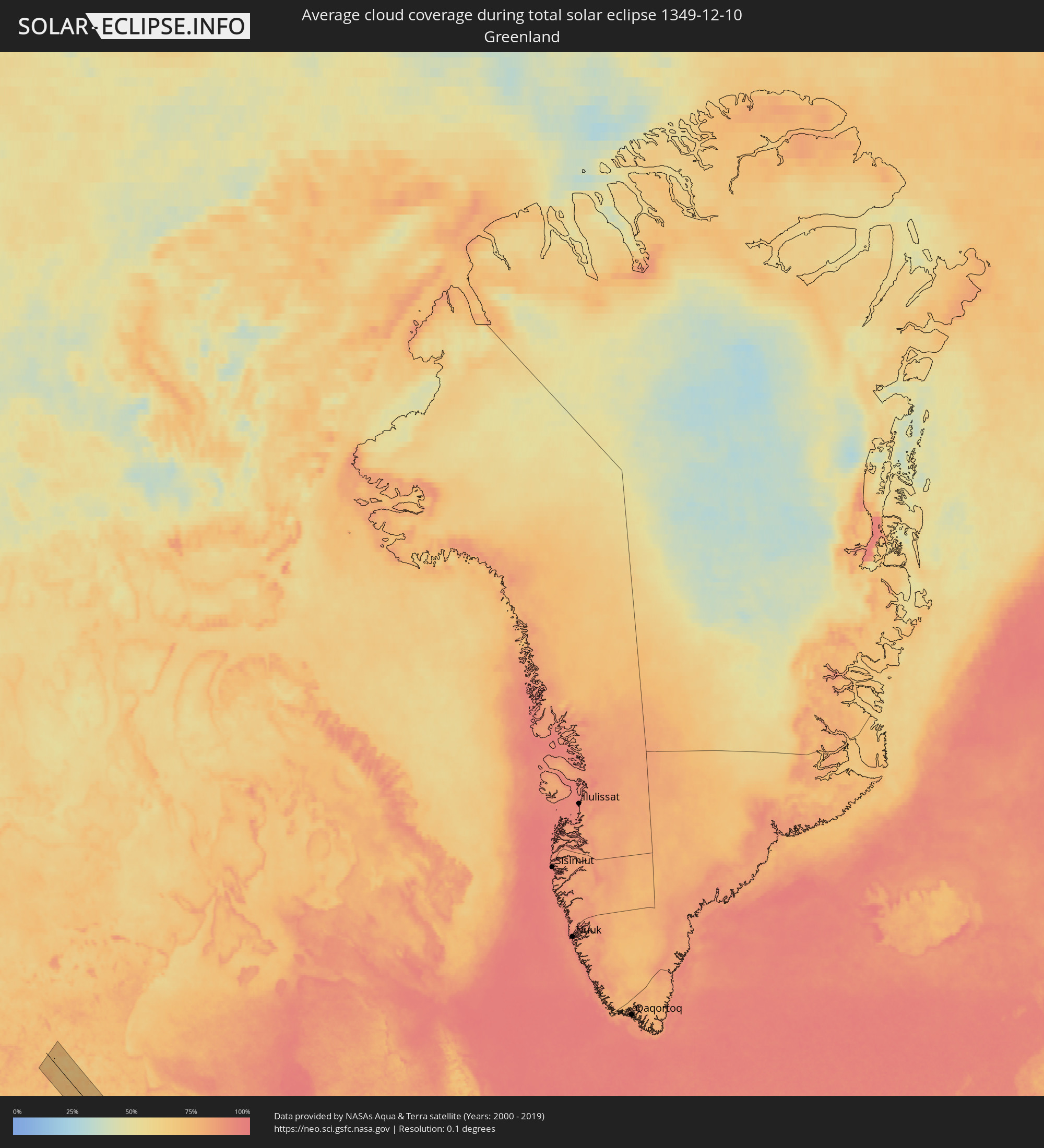 Greenland
Cities inside the path of the eclipse
The following table shows all locations with a population of more than 5,000 inside the eclipse path. Cities which have more than 100,000 inhabitants are marked bold. A click at the locations opens a detailed map.
| City | Type | Eclipse duration | Local time of max. eclipse | Distance to central line | Ø Cloud coverage |
|
Thompson, Manitoba
|
total | - | 09:51:48 UTC-06:00 | 26 km | 72% |
|
Sault Ste. Marie, Michigan
|
total | - | 11:00:11 UTC-05:00 | 88 km | 88% |
|
Sault Ste. Marie, Ontario
|
total | - | 11:00:13 UTC-05:00 | 85 km | 88% |
|
Elliot Lake, Ontario
|
total | - | 11:02:39 UTC-05:00 | 12 km | 91% |
|
Rayside-Balfour, Ontario
|
total | - | 11:04:55 UTC-05:00 | 78 km | 90% |
|
Greater Sudbury, Ontario
|
total | - | 11:05:12 UTC-05:00 | 79 km | 87% |
|
Owen Sound, Ontario
|
total | - | 11:04:34 UTC-05:00 | 84 km | 90% |
|
Collingwood, Ontario
|
total | - | 11:05:43 UTC-05:00 | 56 km | 88% |
|
Orangeville, Ontario
|
total | - | 11:05:44 UTC-05:00 | 100 km | 87% |
|
Parry Sound, Ontario
|
total | - | 11:06:17 UTC-05:00 | 29 km | 91% |
|
Wasaga Beach, Ontario
|
total | - | 11:06:03 UTC-05:00 | 43 km | 89% |
|
Midland, Ontario
|
total | - | 11:06:20 UTC-05:00 | 16 km | 92% |
|
Angus, Ontario
|
total | - | 11:06:12 UTC-05:00 | 54 km | 88% |
|
Brampton, Ontario
|
total | - | 11:06:13 UTC-05:00 | 104 km | 87% |
|
Barrie, Ontario
|
total | - | 11:06:35 UTC-05:00 | 36 km | 88% |
|
Mississauga, Ontario
|
total | - | 11:06:22 UTC-05:00 | 108 km | 85% |
|
Innisfil, Ontario
|
total | - | 11:06:35 UTC-05:00 | 44 km | 88% |
|
Etobicoke, Ontario
|
total | - | 11:06:32 UTC-05:00 | 97 km | 87% |
|
Vaughan, Ontario
|
total | - | 11:06:42 UTC-05:00 | 78 km | 85% |
|
Concord, Ontario
|
total | - | 11:06:43 UTC-05:00 | 80 km | 85% |
|
Keswick, Ontario
|
total | - | 11:06:52 UTC-05:00 | 40 km | 87% |
|
Newmarket, Ontario
|
total | - | 11:06:49 UTC-05:00 | 57 km | 90% |
|
Richmond Hill, Ontario
|
total | - | 11:06:49 UTC-05:00 | 72 km | 87% |
|
Orillia, Ontario
|
total | - | 11:07:03 UTC-05:00 | 6 km | 85% |
|
Toronto, Ontario
|
total | - | 11:06:48 UTC-05:00 | 86 km | 83% |
|
North York, Ontario
|
total | - | 11:06:49 UTC-05:00 | 80 km | 85% |
|
Willowdale, Ontario
|
total | - | 11:06:51 UTC-05:00 | 79 km | 85% |
|
Gravenhurst, Ontario
|
total | - | 11:07:14 UTC-05:00 | 24 km | 90% |
|
East York, Ontario
|
total | - | 11:06:57 UTC-05:00 | 82 km | 82% |
|
Bracebridge, Ontario
|
total | - | 11:07:21 UTC-05:00 | 37 km | 91% |
|
Markham, Ontario
|
total | - | 11:07:06 UTC-05:00 | 64 km | 85% |
|
Scarborough, Ontario
|
total | - | 11:07:05 UTC-05:00 | 72 km | 84% |
|
Huntsville, Ontario
|
total | - | 11:07:36 UTC-05:00 | 68 km | 91% |
|
Pickering, Ontario
|
total | - | 11:07:20 UTC-05:00 | 54 km | 85% |
|
Uxbridge, Ontario
|
total | - | 11:07:25 UTC-05:00 | 36 km | 92% |
|
Ajax, Ontario
|
total | - | 11:07:29 UTC-05:00 | 54 km | 83% |
|
Oshawa, Ontario
|
total | - | 11:07:48 UTC-05:00 | 41 km | 80% |
|
Lockport, New York
|
total | - | 11:07:54 UTC-05:00 | 98 km | 89% |
|
Peterborough, Ontario
|
total | - | 11:08:49 UTC-05:00 | 21 km | 88% |
|
Batavia, New York
|
total | - | 11:08:43 UTC-05:00 | 90 km | 89% |
|
Cobourg, Ontario
|
total | - | 11:08:59 UTC-05:00 | 2 km | 82% |
|
Brockport, New York
|
total | - | 11:09:12 UTC-05:00 | 59 km | 88% |
|
Geneseo, New York
|
total | - | 11:09:19 UTC-05:00 | 91 km | 88% |
|
Rochester, New York
|
total | - | 11:09:45 UTC-05:00 | 49 km | 87% |
|
Quinte West, Ontario
|
total | - | 11:10:03 UTC-05:00 | 46 km | 85% |
|
Belleville, Ontario
|
total | - | 11:10:22 UTC-05:00 | 53 km | 86% |
|
Canandaigua, New York
|
total | - | 11:10:16 UTC-05:00 | 59 km | 88% |
|
Prince Edward, Ontario
|
total | - | 11:10:34 UTC-05:00 | 45 km | 87% |
|
Newark, New York
|
total | - | 11:10:38 UTC-05:00 | 34 km | 88% |
|
Geneva, New York
|
total | - | 11:10:49 UTC-05:00 | 45 km | 88% |
|
Greater Napanee, Ontario
|
total | - | 11:11:08 UTC-05:00 | 82 km | 84% |
|
Elmira, New York
|
total | - | 11:10:59 UTC-05:00 | 108 km | 90% |
|
Auburn, New York
|
total | - | 11:11:33 UTC-05:00 | 20 km | 88% |
|
Oswego, New York
|
total | - | 11:11:45 UTC-05:00 | 31 km | 88% |
|
Ithaca, New York
|
total | - | 11:11:36 UTC-05:00 | 61 km | 91% |
|
Kingston, Ontario
|
total | - | 11:11:56 UTC-05:00 | 102 km | 83% |
|
Fulton, New York
|
total | - | 11:11:53 UTC-05:00 | 23 km | 90% |
|
Cortland, New York
|
total | - | 11:12:12 UTC-05:00 | 32 km | 92% |
|
Syracuse, New York
|
total | - | 11:12:19 UTC-05:00 | 11 km | 90% |
|
Binghamton, New York
|
total | - | 11:12:36 UTC-05:00 | 66 km | 93% |
|
Watertown, New York
|
total | - | 11:12:53 UTC-05:00 | 106 km | 88% |
|
Oneida, New York
|
total | - | 11:13:13 UTC-05:00 | 38 km | 90% |
|
Carbondale, Pennsylvania
|
total | - | 11:13:18 UTC-05:00 | 96 km | 91% |
|
Rome, New York
|
total | - | 11:13:35 UTC-05:00 | 58 km | 90% |
|
Utica, New York
|
total | - | 11:13:58 UTC-05:00 | 58 km | 91% |
|
Oneonta, New York
|
total | - | 11:14:12 UTC-05:00 | 5 km | 93% |
|
Ilion, New York
|
total | - | 11:14:19 UTC-05:00 | 59 km | 90% |
|
Port Jervis, New York
|
total | - | 11:14:48 UTC-05:00 | 79 km | 86% |
|
Lake Mohawk, New Jersey
|
total | - | 11:14:50 UTC-05:00 | 111 km | 85% |
|
Parsippany, New Jersey
|
total | - | 11:15:17 UTC-05:00 | 116 km | 80% |
|
Middletown, New York
|
total | - | 11:15:19 UTC-05:00 | 60 km | 83% |
|
West Milford, New Jersey
|
total | - | 11:15:24 UTC-05:00 | 88 km | 84% |
|
Gloversville, New York
|
total | - | 11:15:35 UTC-05:00 | 94 km | 89% |
|
East Orange, New Jersey
|
total | - | 11:15:42 UTC-05:00 | 115 km | 78% |
|
Amsterdam, New York
|
total | - | 11:15:52 UTC-05:00 | 90 km | 89% |
|
Paterson, New Jersey
|
total | - | 11:15:46 UTC-05:00 | 100 km | 78% |
|
Kiryas Joel, New York
|
total | - | 11:15:48 UTC-05:00 | 59 km | 84% |
|
Ramsey, New Jersey
|
total | - | 11:15:50 UTC-05:00 | 85 km | 79% |
|
Manorville, New York
|
total | - | 11:16:05 UTC-05:00 | 22 km | 81% |
|
Newburgh, New York
|
total | - | 11:16:06 UTC-05:00 | 37 km | 81% |
|
New York City, New York
|
total | - | 11:16:05 UTC-05:00 | 112 km | 80% |
|
Kingston, New York
|
total | - | 11:16:09 UTC-05:00 | 4 km | 78% |
|
New City, New York
|
total | - | 11:16:07 UTC-05:00 | 70 km | 78% |
|
Schenectady, New York
|
total | - | 11:16:19 UTC-05:00 | 90 km | 83% |
|
Poughkeepsie, New York
|
total | - | 11:16:17 UTC-05:00 | 14 km | 82% |
|
Peekskill, New York
|
total | - | 11:16:16 UTC-05:00 | 53 km | 78% |
|
The Bronx, New York
|
total | - | 11:16:21 UTC-05:00 | 93 km | 81% |
|
Greenburgh, New York
|
total | - | 11:16:24 UTC-05:00 | 74 km | 73% |
|
Jamaica, New York
|
total | - | 11:16:28 UTC-05:00 | 105 km | 77% |
|
Oakdale, New York
|
total | - | 11:16:34 UTC-05:00 | 44 km | 80% |
|
Albany, New York
|
total | - | 11:16:38 UTC-05:00 | 83 km | 84% |
|
Mahopac, New York
|
total | - | 11:16:37 UTC-05:00 | 37 km | 80% |
|
Mount Kisco, New York
|
total | - | 11:16:38 UTC-05:00 | 53 km | 77% |
|
Glen Cove, New York
|
total | - | 11:16:48 UTC-05:00 | 82 km | 73% |
|
Hempstead, New York
|
total | - | 11:16:49 UTC-05:00 | 96 km | 72% |
|
Stamford, Connecticut
|
total | - | 11:16:59 UTC-05:00 | 59 km | 72% |
|
Danbury, Connecticut
|
total | - | 11:17:09 UTC-05:00 | 23 km | 77% |
|
Wilton, Connecticut
|
total | - | 11:17:11 UTC-05:00 | 41 km | 74% |
|
Huntington Station, New York
|
total | - | 11:17:14 UTC-05:00 | 73 km | 73% |
|
Lindenhurst, New York
|
total | - | 11:17:18 UTC-05:00 | 88 km | 70% |
|
Brentwood, New York
|
total | - | 11:17:33 UTC-05:00 | 73 km | 69% |
|
Pittsfield, Massachusetts
|
total | - | 11:17:35 UTC-05:00 | 86 km | 90% |
|
Southbury, Connecticut
|
total | - | 11:17:37 UTC-05:00 | 4 km | 80% |
|
Bridgeport, Connecticut
|
total | - | 11:17:38 UTC-05:00 | 34 km | 71% |
|
Torrington, Connecticut
|
total | - | 11:17:48 UTC-05:00 | 30 km | 82% |
|
North Adams, Massachusetts
|
total | - | 11:17:51 UTC-05:00 | 116 km | 90% |
|
Waterbury, Connecticut
|
total | - | 11:17:56 UTC-05:00 | 10 km | 79% |
|
Bayport, New York
|
total | - | 11:17:55 UTC-05:00 | 69 km | 67% |
|
Coram, New York
|
total | - | 11:18:01 UTC-05:00 | 54 km | 72% |
|
Bristol, Connecticut
|
total | - | 11:18:08 UTC-05:00 | 25 km | 78% |
|
New Haven, Connecticut
|
total | - | 11:18:10 UTC-05:00 | 9 km | 69% |
|
Mastic, New York
|
total | - | 11:18:20 UTC-05:00 | 54 km | 70% |
|
Meriden, Connecticut
|
total | - | 11:18:24 UTC-05:00 | 18 km | 78% |
|
Southwick, Massachusetts
|
total | - | 11:18:28 UTC-05:00 | 69 km | 82% |
|
Hartford, Connecticut
|
total | - | 11:18:38 UTC-05:00 | 45 km | 77% |
|
Guilford, Connecticut
|
total | - | 11:18:38 UTC-05:00 | 0 km | 68% |
|
Northampton, Massachusetts
|
total | - | 11:18:43 UTC-05:00 | 100 km | 82% |
|
Windsor Locks, Connecticut
|
total | - | 11:18:45 UTC-05:00 | 63 km | 79% |
|
Springfield, Massachusetts
|
total | - | 11:18:49 UTC-05:00 | 81 km | 82% |
|
Hampton Bays, New York
|
total | - | 11:18:58 UTC-05:00 | 34 km | 71% |
|
East Haddam, Connecticut
|
total | - | 11:19:04 UTC-05:00 | 25 km | 76% |
|
Old Saybrook, Connecticut
|
total | - | 11:19:14 UTC-05:00 | 13 km | 67% |
|
Tolland, Connecticut
|
total | - | 11:19:14 UTC-05:00 | 69 km | 81% |
|
Hebron, Connecticut
|
total | - | 11:19:15 UTC-05:00 | 48 km | 81% |
|
Palmer, Massachusetts
|
total | - | 11:19:19 UTC-05:00 | 98 km | 82% |
|
Mansfield City, Connecticut
|
total | - | 11:19:30 UTC-05:00 | 64 km | 80% |
|
New London, Connecticut
|
total | - | 11:19:46 UTC-05:00 | 30 km | 71% |
|
Norwich, Connecticut
|
total | - | 11:19:48 UTC-05:00 | 48 km | 74% |
|
Southbridge, Massachusetts
|
total | - | 11:19:53 UTC-05:00 | 102 km | 78% |
|
Plainfield, Connecticut
|
total | - | 11:20:07 UTC-05:00 | 69 km | 76% |
|
Killingly Center, Connecticut
|
total | - | 11:20:12 UTC-05:00 | 87 km | 79% |
|
Auburn, Massachusetts
|
total | - | 11:20:15 UTC-05:00 | 122 km | 75% |
|
Westerly, Rhode Island
|
total | - | 11:20:18 UTC-05:00 | 44 km | 71% |
|
Coventry, Rhode Island
|
total | - | 11:20:34 UTC-05:00 | 81 km | 75% |
|
Charlestown, Rhode Island
|
total | - | 11:20:39 UTC-05:00 | 52 km | 67% |
|
Woonsocket, Rhode Island
|
total | - | 11:20:53 UTC-05:00 | 117 km | 75% |
|
North Kingstown, Rhode Island
|
total | - | 11:20:59 UTC-05:00 | 75 km | 73% |
|
Providence, Rhode Island
|
total | - | 11:21:05 UTC-05:00 | 104 km | 72% |
|
Newport East, Rhode Island
|
total | - | 11:21:20 UTC-05:00 | 79 km | 64% |
|
Attleboro, Massachusetts
|
total | - | 11:21:19 UTC-05:00 | 121 km | 75% |
|
Fall River, Massachusetts
|
total | - | 11:21:35 UTC-05:00 | 103 km | 69% |
|
New Bedford, Massachusetts
|
total | - | 11:22:01 UTC-05:00 | 105 km | 64% |
|
Mashpee, Massachusetts
|
total | - | 11:22:54 UTC-05:00 | 125 km | 67% |